Next Issue
Volume 13, March
Previous Issue
Volume 13, January


Land, Volume 13, Issue 2 (February 2024) – 140 articles

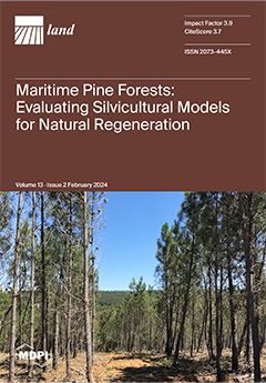
Cover Story (view full-size image): Maritime pine forests in the Mediterranean face sustainability challenges from recurrent fires and delayed management. This study, conducted in North Portugal, assesses four management scenarios for natural regeneration. Stand ages range from 6 to 16 years with densities from 15,000 to circa 93,000 trees per ha. Using Modispinaster and PiroPinus models, scenarios range from no intervention to intensive methods. Scenario C4, involving early opening strips, selective tree retention, and timely thinning, proves to be more effective, increasing the production of larger diameter timber without compromising fire resistance. Sustainable management hinges on early intervention and careful silvicultural planning. View this paper
  • Issues are regarded as officially published after their release is announced to the table of contents alert mailing list.
  • You may sign up for e-mail alerts to receive table of contents of newly released issues.
  • PDF is the official format for papers published in both, html and pdf forms. To view the papers in pdf format, click on the "PDF Full-text" link, and use the free Adobe Reader to open them.
Order results
Result details
Section
Select all
Export citation of selected articles as:
17 pages, 5827 KiB  
Article
Spatial–Temporal Evolution Analysis of the Development of Jingdang and Famen Townships in the Vicinity of the Capital City Site of the Western Zhou Dynasty in China
by Jian Chen, Kai Wang, Yingqiang Yuan, Peiyao Li, Lixin Niu, Jiangning Song and Yanlong Zhang
Land 2024, 13(2), 263; https://doi.org/10.3390/land13020263 - 19 Feb 2024
Viewed by 783
Abstract
This study aimed to explore the evolution of Jingdang and Famen towns near the Zhouyuan site, the capital city site of the Western Zhou Dynasty in China, to elucidate the relationship between township development and the essential ancient relics conservation areas. Based on [...] Read more.
This study aimed to explore the evolution of Jingdang and Famen towns near the Zhouyuan site, the capital city site of the Western Zhou Dynasty in China, to elucidate the relationship between township development and the essential ancient relics conservation areas. Based on the remote sensing satellite images from 1982 to 2022, combining with historical demographic data, this study used four methods, including land use classification, land use transfer matrix, landscape pattern center of gravity changes, and population count statistics, to study the spatial–temporal evolution of land, population, and ecology in the region over the past 40 years. The results showed that under the strict relic conservation regimen, these two towns are in a declining stage. To improve their decaying status, some potential strategies valuable for township development are proposed to balance the relationship between relic conservation and township development for their mutual benefit and coexistence. Full article
(This article belongs to the Special Issue Land Use in Archaeology)
Show Figures

Figure 1

21 pages, 780 KiB  
Article
The Impact of Internet Use on Land Productivity: Evidence from China Land Economy Survey
by Xiang Deng, Jie Peng and Chunlin Wan
Land 2024, 13(2), 262; https://doi.org/10.3390/land13020262 - 19 Feb 2024
Cited by 1 | Viewed by 1157
Abstract
Enhancing land productivity is a crucial strategy for addressing key sustainable development issues, such as poverty reduction and ensuring food security. Farmers’ Internet use behavior offers the potential to improve land productivity. However, relatively little is known about the association between Internet use [...] Read more.
Enhancing land productivity is a crucial strategy for addressing key sustainable development issues, such as poverty reduction and ensuring food security. Farmers’ Internet use behavior offers the potential to improve land productivity. However, relatively little is known about the association between Internet use and land productivity. To fill this void, this study examines the impact of Internet use on land productivity and its mechanisms. The results indicate that farmers’ use of the Internet has a positive impact on improving agricultural land productivity. Internet use increases land productivity by 12.3%, and the conclusion still holds after a series of robustness tests and endogeneity tests. Heterogeneity analysis indicates that Internet use significantly enhances land productivity in the central and northern parts of Jiangsu Province, while it does not have the same effect in the province’s southern regions. Without the addition of county fixed effects, the central sample regression results show that the coefficient for Internet use is 0.165 and significant at the 10% confidence level. When county fixed effects are added, the coefficient decreases to 0.117 and is not significant. The coefficient on Internet use for the northern sample is 0.128 and is significant at the 5% confidence level. Mechanistic analyses demonstrate that Internet use also enhances land productivity primarily by expanding the cultivated land area, facilitating mechanized production, and strengthening farmers’ social networks. The results of the study indicate that the positive effects of Internet use in improving land productivity should be fully released by strengthening the communication infrastructure, further enhancing farmers’ Internet use capacity, improving the land transfer system, upgrading the socialized service level of agricultural machinery, and strengthening agricultural financial support. Full article
Show Figures

Figure 1

17 pages, 6425 KiB  
Article
Measuring Perceived Walkability at the City Scale Using Open Data
by Yang Ye, Chaozhi Jia and Stephan Winter
Land 2024, 13(2), 261; https://doi.org/10.3390/land13020261 - 19 Feb 2024
Viewed by 1002
Abstract
The walkability of the built environment has been shown to be critical to the health of residents, and open data have been widely used to assess walkability. However, previous research has focused on the relationship between the built environment and walking behavior rather [...] Read more.
The walkability of the built environment has been shown to be critical to the health of residents, and open data have been widely used to assess walkability. However, previous research has focused on the relationship between the built environment and walking behavior rather than perceived walkability, and there is a lack of systematic research on walkability at the urban scale using open data. This paper presents a methodological framework for systematically measuring and assessing perceived walkability at the urban scale, considering general and specific features. The walkability indices are obtained using variables from open data or calculated automatically through machine learning and algorithms to ensure they can be evaluated at a larger urban scale. The proposed method is applied to Harbin, China, to assess the perceived walkability of streets using hundreds of thousands of street view images and points of interest obtained from open data. The results are compared with a subjective evaluation of walkability to validate the proposed method. The results demonstrate that measures of the urban built environment can describe perceived walkability. Thus, the proposed framework shows promise for assessing the walkability of urban spaces, supporting policy proposals, and establishing design guidelines for optimising urban spaces. Full article
(This article belongs to the Special Issue Built Environment, Pedestrian Behaviors, and Urban Sustainability)
Show Figures

Figure 1

22 pages, 12036 KiB  
Article
Spatiotemporal Characteristics of Land Cover Change in the Yellow River Basin over the Past Millennium
by Yafei Wang, Fan Yang and Fanneng He
Land 2024, 13(2), 260; https://doi.org/10.3390/land13020260 - 19 Feb 2024
Viewed by 847
Abstract
Investigating the ecological and environmental impacts stemming from historical land use and land cover change (LUCC) holds paramount importance in systematically comprehending the fundamental human-land relationship, a pivotal focus within geographical research. The Yellow River Basin (YRB), often referred to as the cradle [...] Read more.
Investigating the ecological and environmental impacts stemming from historical land use and land cover change (LUCC) holds paramount importance in systematically comprehending the fundamental human-land relationship, a pivotal focus within geographical research. The Yellow River Basin (YRB), often referred to as the cradle of Chinese civilization, ranks as the fifth-largest river basin globally. Early inhabitants made significant alterations to the landscape, resulting in substantial damage to natural vegetation, giving rise to prominent regional ecological challenges. By now, the examination of historical LUCC in the YRB over the past millennium remains in the qualitative research stage, primarily due to the limited availability of high-confidence gridded historical LUCC data. This study aims to advance the current historical LUCC research in the YRB from primarily qualitative analysis to an exploration incorporating timing, positioning, and quantification. Based on reconstructed historical cropland, forest, and grassland grid data of 10 km × 10 km from 1000 AD to 2000 AD, the degree of cropland development and the depletion of forests and grasslands were calculated, respectively. Then, the kernel density method was employed for spatiotemporal analysis and interpretation of dynamic changes in land cover. Subsequently, a cartographic visualization depicting the migration trajectories of the land cover gravity centers was generated, allowing for an assessment of the distance and direction of the centroids’ movement of cropland, forest, and grassland. The results indicate that the cropland coverage in the YRB escalated from the initial 11.65% to 29.97%, while the forest and grassland coverage dropped from 63.36% to 44.49%. The distribution of cultivated land continually expanded outward from the southeast of the Loess Plateau and the southwest of the North China Plain. All three types of land cover experienced a westward shift in their gravity centers between 1000 and 2000 AD. Besides the population growth and technological advancements, the regime shifts induced by wars, along with land use policies in distinct periods, always served as the predominant factors influencing the conversion between different land covers. This research will present a paradigmatic regional case study contributing to the investigation of historical changes in land use and land cover. Additionally, it will offer historical perspectives beneficial for the advancement of China’s objectives in “Ecological Conservation and High-Quality Development of the Yellow River Basin”. Full article
(This article belongs to the Special Issue Deciphering Land-System Dynamics in China)
Show Figures

Figure 1

24 pages, 30659 KiB  
Article
Land Cover Changes and Driving Factors in the Source Regions of the Yangtze and Yellow Rivers over the Past 40 Years
by Xiuyan Zhang, Yuhui Yang, Haoyue Gao, Shu Xu, Jianming Feng and Tianling Qin
Land 2024, 13(2), 259; https://doi.org/10.3390/land13020259 - 19 Feb 2024
Viewed by 700
Abstract
As a climate-sensitive region of the Tibetan Plateau, the source regions of the Yangtze and Yellow Rivers (SRYYRs) urgently require an analysis of land cover change (LUCCs) over a long period, high temporal resolution, and high spatial resolution. This study utilizes nearly 40 [...] Read more.
As a climate-sensitive region of the Tibetan Plateau, the source regions of the Yangtze and Yellow Rivers (SRYYRs) urgently require an analysis of land cover change (LUCCs) over a long period, high temporal resolution, and high spatial resolution. This study utilizes nearly 40 years of land cover, the Normalized Difference Vegetation Index (NDVI), climate, and geomorphological data, applying methods including a land transfer matrix, slope trend analysis, correlation analysis, and landscape pattern indices to analyze the spatial and temporal changes, composition, layout, and quality of the local land cover and the factors. The findings reveal that (1) the land cover area change rate was 8.96% over the past 40 years, the unutilized land area decreased by 24.49%, and the grassland area increased by 6.37%. The changes were obvious at the junction of the two source regions and the southeast side of the source region of the Yellow River. (2) the landscape pattern was more centralized and diversified. The number of low-cover grassland patches increased by 12.92%. (3) The region is still dominated by medium- and low-cover vegetation, with the mean annual NDVI increasing at a rate of 0.006/10a, and the rate of change after 2000 is three times higher than previously. (4) The degree of land cover change is greater in the middle altitudes, semisunny aspects, steepest slopes, and middle-relief mountains. Additionally, 76.8% of the region’s vegetation growth is dominated by mean annual temperatures. This study provides fundamental data and theory for understanding LUCCs and the driving factors in alpine plateau regions. Full article
(This article belongs to the Special Issue Impact of Climate Change on Land and Water Systems)
Show Figures

Figure 1

23 pages, 23364 KiB  
Article
Exploring Integrative Development of Urban Agglomeration from the Perspective of Urban Symbiosis and Production–Living–Ecological Function
by Sijia Lin, Chun Li, Yanbo Li and Liding Chen
Land 2024, 13(2), 258; https://doi.org/10.3390/land13020258 - 19 Feb 2024
Viewed by 704
Abstract
Integrative development is an effective way to enhance urban potential and implement resource-optimal relocation, especially in urban agglomeration regions. Conventionally, the evaluation of urban integration is usually studied from one aspect of urban interaction intensity or urban functional similarity, but considering both together [...] Read more.
Integrative development is an effective way to enhance urban potential and implement resource-optimal relocation, especially in urban agglomeration regions. Conventionally, the evaluation of urban integration is usually studied from one aspect of urban interaction intensity or urban functional similarity, but considering both together can better reflect the integrative condition of urban agglomeration. This paper introduces the symbiosis theory into the exploration of urban integration. The production–living–ecological function is taken to analyze urban function, and the improved radiation model is adopted to measure urban interaction. Under the framework of symbiosis theory, we integrate urban function and urban interaction to indicate the integrative condition of urban agglomeration from a production–living–ecological aspect. Urban agglomeration in the Central Yunnan Urban Agglomeration is taken as the study area. The results show that (1) spatial variations occur in high-value areas with distinct functions. The east emphasizes production and living, while the west leans towards ecology. (2) Urban agglomeration is in its early developmental stages without stable symbiosis. Interactions among counties mostly show sporadic point symbiosis, lacking stability. It mainly radiates outward from the central area, with more stable interactions in high-value areas, often causing inter-city competition. (3) Urban agglomeration integration is generally low, with distinct high-value production and ecological areas. The central, eastern, and southern regions exhibit strong production and living interactions, while the west benefits from ecological interactions. These findings can offer some insights for informing relevant policies and fostering the integrated development of urban agglomerations. Full article
Show Figures

Figure 1

16 pages, 15524 KiB  
Article
Using Different Extraction Methods to Estimate Soil Salinity and Salt Type Changes and Their Effects on Soil Inorganic Carbon in Plowed Desert–Sierozem Soil
by Kang Peng, Fang Zhang and Zhidong Shao
Land 2024, 13(2), 257; https://doi.org/10.3390/land13020257 - 19 Feb 2024
Viewed by 762
Abstract
Understanding the actual soil salt ion content and salt type is one of the important prerequisites for determining the nature of saline soils and their development and utilization in drylands. Desert–sierozem soils are widely distributed in the plains between the northern piedmont of [...] Read more.
Understanding the actual soil salt ion content and salt type is one of the important prerequisites for determining the nature of saline soils and their development and utilization in drylands. Desert–sierozem soils are widely distributed in the plains between the northern piedmont of the Tianshan Mountains and the Gurbantunggut Desert in Xinjiang, Northwest China, which contain abundant calcium sulfate (gypsum) and calcium carbonate and are high-quality arable land resources for agriculture. These soils have been extensively reclaimed for farmland in recent decades. In this study, 10 plots of desert–sierozem soils with different tillage years in the Qitai Oasis plain area in the northern piedmont of Tianshan Mountain were studied. Three soil profiles were excavated in each sample plot with a depth of 1.2 m. A total of 30 farmland profiles were dug up and sampling was conducted according to the soil occurrence layers of the farmland. All the soil samples were predominantly sandy in texture, with more than 92% of the soil particles distributed between 0.05 and 0.25 mm, and less than 8% between 0.002 and 0.05 mm. Conventional water extraction (CWE) and intensified water extraction (IWE) were adopted to extract the water-soluble salt ions content of K+, Na+, Ca2+, Mg2+, Cl, SO42−, HCO3 and CO32−, and this study compared the extraction results using two different methods with varying extraction strengths. Additionally, the calcium sulfate and calcium carbonate contents were obtained using the chemical extraction and mineral assay methods, respectively. Differences in the salts and salt types in desert–sierozem soils with different tillage years were analyzed, and the effect of calcium sulfate on the inorganic carbon sinks in plowed desert–sierozem soil was demonstrated. The findings indicated that the standard conventional extraction procedure involving a 5:1 water–soil ratio and 3 min of shaking was inadequate for accurately measuring the soil salt content in high calcium sulfate content desert–sierozem soils. With the IWE method, by increasing the water–soil ratio, prolonging the shaking time, and grinding the particles finer, the amount of water-soluble salts extracted using the IWE method was 5.83 times higher than that of the conventional method. Among them, the average content of IWE-Mg2+ increased by 123.41 mg kg−1 compared to CWE-Mg2+, the average content of IWE-Ca2+ was 3.82 times higher than CWE-Ca2+, with an average increase of 2931.59 mg kg−1, and the IWE-SO42− content was 5.96 times higher than CWE-SO42−, with an average increase of 8658.95 mg kg−1. A markedly negative correlation (p < 0.01) was observed between calcium carbonate and calcium sulfate in desert–sierozem soils after tillage. The calcium sulfate content consistently decreased and calcium carbonate increased with an increasing number of tillage years. The pedogenic calcium carbonate content in desert–sierozem soils increased by an average of 10.86 g kg−1 after more than 40 years of cultivation, and the transfer of Ca2+ from calcium sulfate to calcium carbonate was identified as the cause of the increase in the soil inorganic carbon sink. Overall, a new method for extracting water-soluble salts was utilized for aridisols, which commonly consist of complex salt types. The results elucidate the changes in salinity within plowed desert–sierozem soils as well as the impact of soil salt on soil inorganic carbon sinks. Based on our research, desert–sierozem soils are well suited for agricultural farming because they contain high levels of sulfate, which is one of the important inorganic nutrients essential for crops, and it also provides a source of calcium for increasing inorganic carbon sinks. This study serves as a reference and scientific basis for soil carbon cycles in arid zones. Full article
Show Figures

Figure 1

18 pages, 4956 KiB  
Article
Spatial-Temporal Heterogeneity of Ecosystem Service Value Driven by Nature-Human Activity-Policy in a Representative Fragile Karst Trough Valley, SW China
by Cheng Zeng, Gaoning Zhang, Tianyang Li, Binghui He and Dengyu Zhang
Land 2024, 13(2), 256; https://doi.org/10.3390/land13020256 - 19 Feb 2024
Viewed by 643
Abstract
Most studies on the ecosystem service value (ESV) only focus on spatial/temporal heterogeneity or single driving effects, but little is known about the combined effects of nature-human activity-policy on ESV in the fragile karst areas. This study aimed to investigate the spatial-temporal heterogeneity [...] Read more.
Most studies on the ecosystem service value (ESV) only focus on spatial/temporal heterogeneity or single driving effects, but little is known about the combined effects of nature-human activity-policy on ESV in the fragile karst areas. This study aimed to investigate the spatial-temporal heterogeneity of ESV between 1990 and 2020 in a representative karst trough valley in SW China. The dynamic degree of land use, the land-use transfer matrix, sensitive analyses, Geo-Detector, and Hot- and cold-spots analyses were used to determine the interactions between ESV and the natural, human activity, and policy-driving factors. The results showed that from 1990 to 2020, forestland accounted for more than 62.32% of the total area, and construction land increased continuously as a result of urbanization. The conversion from forestland to cropland dominated the land-use transfer. The ESV decreased sharply between 1990 and 2000 and slowly increased from 2000 to 2020, causing a total reduction of 562.91 million yuan in ESV, due largely to the occupation of forestland and grassland by cropland. Soil type (8.00%) had the largest explanation rate for the spatial-temporal heterogeneity of ESV, followed by population density (7.71%) and altitude (6.34%). Policy factors not only markedly influenced the ecosystem structure and function and tradeoff and synergy but also regulated their interactions with other driving factors. Our results have great significance for understanding the interaction effect of natural sources and human activities on changes in ESV in karst areas. Full article
(This article belongs to the Topic Karst Environment and Global Change)
Show Figures

Figure 1

15 pages, 2556 KiB  
Article
Analysis of Urban Congestion Traceability: The Role of the Built Environment
by Chenguang Li, Duo Wang, Hong Chen and Enze Liu
Land 2024, 13(2), 255; https://doi.org/10.3390/land13020255 - 19 Feb 2024
Viewed by 1116
Abstract
Analyzing the factors influencing traffic congestion is essential for urban planning and coordinated development. Previous research frequently focuses on the internal aspects of traffic systems, often overlooking the impact of external factors on congestion sources. Therefore, this study utilizes a geospatial dataset and [...] Read more.
Analyzing the factors influencing traffic congestion is essential for urban planning and coordinated development. Previous research frequently focuses on the internal aspects of traffic systems, often overlooking the impact of external factors on congestion sources. Therefore, this study utilizes a geospatial dataset and mobile signaling data, firstly applying the Fuzzy C-Means (FCM) algorithm to identify congested roads of different levels and trace the localization of travelers’ origins on regional congested roads. Furthermore, it employs the LightGBM method to study the influence of the built environment of various congestion sources on network-level congestion. The findings are as follows: (1) There is a positive correlation between traffic congestion and geographical location, with congestion predominantly caused by a few specific plots and demonstrating a concentrated trend in city centers. (2) Residential population density is the most critical factor, accounting for over 12% of the congestion contribution, followed by road density and working population density. (3) Both residential and working population densities show a non-linear positive correlation with congestion contribution, while the mixture of land use displays a non-linear V-shaped influence. Additionally, when residential population density is between 8000 and 11,000, it notably exacerbates congestion contribution. Significantly, by emphasizing land use considerations in traffic system analysis, these findings illuminate the intricate linkages between urban planning and traffic congestion, advocating for a more comprehensive approach to urban development strategies. Full article
(This article belongs to the Topic Urban Land Use and Spatial Analysis)
Show Figures

Figure 1

16 pages, 3196 KiB  
Article
Enhancing Urban Landscape Design: A GAN-Based Approach for Rapid Color Rendering of Park Sketches
by Ran Chen, Jing Zhao, Xueqi Yao, Yueheng He, Yuting Li, Zeke Lian, Zhengqi Han, Xingjian Yi and Haoran Li
Land 2024, 13(2), 254; https://doi.org/10.3390/land13020254 - 18 Feb 2024
Viewed by 987
Abstract
In urban ecological development, the effective planning and design of living spaces are crucial. Traditional color plan rendering methods, mainly using generative adversarial networks (GANs), rely heavily on edge extraction. This often leads to the loss of important details from hand-drawn drafts, significantly [...] Read more.
In urban ecological development, the effective planning and design of living spaces are crucial. Traditional color plan rendering methods, mainly using generative adversarial networks (GANs), rely heavily on edge extraction. This often leads to the loss of important details from hand-drawn drafts, significantly affecting the portrayal of the designer’s key concepts. This issue is especially critical in complex park planning. To address this, our study introduces a system based on conditional GANs. This system rapidly converts black-and-white park sketches into comprehensive color designs. We also employ a data augmentation strategy to enhance the quality of the output. The research reveals: (1) Our model efficiently produces designs suitable for industrial applications. (2) The GAN-based data augmentation improves the data volume, leading to enhanced rendering effects. (3) Our unique approach of direct rendering from sketches offers a novel method in urban planning and design. This study aims to enhance the rendering aspect of an intelligent workflow for landscape design. More efficient rendering techniques will reduce the iteration time of early design solutions and promote the iterative speed of designers’ thinking, thus improving the speed and efficiency of the whole design process. Full article
Show Figures

Figure 1

19 pages, 3061 KiB  
Article
Theoretical Logic and Implementation Path of Comprehensive Land Consolidation for Promoting Common Prosperity: A Case Study of Ningbo City
by Xiaoping Zhou, Yu Lv, Jieyu Zou and Xiaokun Gu
Land 2024, 13(2), 253; https://doi.org/10.3390/land13020253 - 18 Feb 2024
Viewed by 684
Abstract
Eliminating poverty and achieving social justice are global concerns. China has focused on common prosperity. Comprehensive land consolidation is a potential policy tool that can contribute to common prosperity, but its effectiveness and implementation methods are yet to be verified and discussed. Therefore, [...] Read more.
Eliminating poverty and achieving social justice are global concerns. China has focused on common prosperity. Comprehensive land consolidation is a potential policy tool that can contribute to common prosperity, but its effectiveness and implementation methods are yet to be verified and discussed. Therefore, we construct an analytical framework to understand how comprehensive land consolidation promotes common prosperity. The pilot area for comprehensive land consolidation in Ningbo City is used as a qualitative case study. The research results indicate that comprehensive land consolidation focuses on development and sharing to promote high-quality socio-economic development, social fairness, and justice. The paths for achieving development included the following: (1) a network governance structure consisting of multiple entities to enhance land governance; (2) various consolidation activities were conducted at the town scale to optimize the functionality and spatial pattern of public spaces; and (3) enabling the flow of urban and rural factors for improved resource allocation efficiency and providing an impetus for industrial development. The paths for achieving sharing included clarifying collective land ownership and promoting land transactions to provide diverse land values and ensure a shared distribution. This research provides new insights applicable to other Chinese cities and numerous developing countries engaged in land consolidation to address social distribution issues. Full article
Show Figures

Figure 1

15 pages, 2450 KiB  
Article
Military Activity Impact on Vegetation in Pannonian Dry Sandy Grasslands
by Márta Bajnok, Károly Penksza, Attila Fűrész, Péter Penksza, Péter Csontos, Szilárd Szentes, Ferenc Stilling, Eszter Saláta-Falusi, Márta Fuchs, Caleb Melenya, Judit Házi, Dániel Balogh and Zsombor Wagenhoffer
Land 2024, 13(2), 252; https://doi.org/10.3390/land13020252 - 18 Feb 2024
Viewed by 654
Abstract
The conservation of dry sandy grasslands is a global issue because of the restoration and conservation of endangered ecosystems to provide a sufficient amount of forage under warming and drying climatic conditions. Our aim was to explore the impact of military activity on [...] Read more.
The conservation of dry sandy grasslands is a global issue because of the restoration and conservation of endangered ecosystems to provide a sufficient amount of forage under warming and drying climatic conditions. Our aim was to explore the impact of military activity on sandy grasslands in Hungary. The sample areas chosen were the Little Hungarian Plain (I. and II.) and the Great Hungarian Plain (III.), consisting abandoned, restored areas; still-active military exercise fields; and shooting ranges. In each sample area, six to ten coenological surveys were made. Based on our survey, the closed natural sandy grassland was documented only in the Little Hungarian Plain and were found rich in species. The open sandy grassland was described in all studied sites, Festuca vaginata appeared in all of them, while Festuca pseudovaginata was observed only in the Great Hungarian Plain. In the open sandy grassland, the natural vegetation had the highest cover value (78.8%), the sowed grassland area had the least cover value (53.3%), while the III. sample area was also poor in coverage (56.5%) but consisted of a natural species composition favorable for restoration. Our results confirmed the indirect role of military activity in the successful habitat conservation of Pannonian dry sandy grassland ecosystems. Full article
Show Figures

Figure 1

22 pages, 897 KiB  
Article
The Impact of Dialect Diversity on Rent-Free Farmland Transfers: Evidence from Chinese Rural Household Surveys
by Shangpu Li, Ye Jiang, Biliang Luo and Xiaodan Zheng
Land 2024, 13(2), 251; https://doi.org/10.3390/land13020251 - 18 Feb 2024
Viewed by 590
Abstract
The rent-free farmland transfer that exists widely in China’s rural areas is a topic worthy of attention. Particularly, the regional heterogeneity of its occurrences implies regional cultural heterogeneities. Using local dialects to proxy regional cultural features, this study applies econometric methods to examine [...] Read more.
The rent-free farmland transfer that exists widely in China’s rural areas is a topic worthy of attention. Particularly, the regional heterogeneity of its occurrences implies regional cultural heterogeneities. Using local dialects to proxy regional cultural features, this study applies econometric methods to examine the impacts of dialect diversity on rent-free farmland transfers. It also considers possible mechanisms through a mediation analysis, based on a combined two-year rural household survey dataset from the Guangdong and Jiangxi Provinces in 2015 and 2016. Robust estimation results reveal that dialect diversity increases the probability of rent-free farmland transfers at the household and village levels. According to the mediation analysis, dialect diversity influences villages’ farmland abandonment, rural farmland market development, and the flexibility of farmland transfer contracts, which further affects rent-free farmland transfer. Rent-free farmland transfer depends on social trust and contracts’ self-fulfilling advantages. Therefore, cultural and traditional factors should be taken into consideration, which would form beneficial interactions between the selections of rural farmland institutional arrangement and land rights policy implementations. Full article
Show Figures

Figure 1

19 pages, 4170 KiB  
Article
The Impact of Commercial-Industry Development of Urban Vitality: A Study on the Central Urban Area of Guangzhou Using Multisource Data
by Lixin Liu, Yanjun Dong, Wei Lang, Huiyu Yang and Bin Wang
Land 2024, 13(2), 250; https://doi.org/10.3390/land13020250 - 18 Feb 2024
Viewed by 991
Abstract
Urban commercial centers play a critical role in the development of cities, and it is of significant relevance to research the influencing variables of the urban vitality of commercial centers to improve the quality of urban commercial centers. This study employs big data [...] Read more.
Urban commercial centers play a critical role in the development of cities, and it is of significant relevance to research the influencing variables of the urban vitality of commercial centers to improve the quality of urban commercial centers. This study employs big data to construct a multiple linear regression model in order to uncover the spatial-distribution characteristics of urban vitality and commercial sectors in commercial centers within the primary urban region of Guangzhou. The findings indicate that the commercial sectors of life, business, finance, and leisure have a substantial influence on the fluctuation of pedestrian flow in commercial centers throughout the day. Conversely, public service commercial sectors do not have a significant impact on pedestrian flow. Furthermore, the effect of various commercial sectors on the vibrancy of urban commercial centers varies, and their performance differs on weekdays and holidays. Additionally, the level of integration among commercial sectors affects the vitality of the city’s commercial space. This research presents empirical facts that can be used to optimize the logical allocation of urban commercial resources in urban planning. Full article
(This article belongs to the Topic Urban Land Use and Spatial Analysis)
Show Figures

Figure 1

30 pages, 5413 KiB  
Article
The Interconnectivity and Spatio-Temporal Evolution of Rail Transit Network Based on Multi-Element Flows: A Case Study of Beijing-Tianjin-Hebei Urban Agglomeration, China
by Xinyu Luan, Pengcheng Xiang and Fuyuan Jia
Land 2024, 13(2), 249; https://doi.org/10.3390/land13020249 - 18 Feb 2024
Viewed by 771
Abstract
For intercity transportation within urban agglomerations, rail transit interconnectivity not only stimulates city-to-city interactions but also facilitates the networking of urban spaces. Crucially, comprehending the spatial network of urban agglomerations needs a focus on rail transit interconnectivity. Drawing on the space of flows [...] Read more.
For intercity transportation within urban agglomerations, rail transit interconnectivity not only stimulates city-to-city interactions but also facilitates the networking of urban spaces. Crucially, comprehending the spatial network of urban agglomerations needs a focus on rail transit interconnectivity. Drawing on the space of flows theory, this study establishes a framework to evaluate rail transit interconnectivity and the spatial structure of urban agglomerations, utilizing the Beijing-Tianjin-Hebei urban agglomeration as a case study. The objective of this study is to explore the impact of rail transit interconnectivity on the spatial structure in the urban agglomeration. Firstly, it establishes a coupled concept of urban quality and line quality to elucidate the interaction between rail transits and urban development. Secondly, it employs the AHP-CRITIC-TOPSIS and modified gravity model to evaluate the interconnectivity degree of rail transits and visualize the network. Thirdly, based on the multi-element flows facilitated by rail transit interconnectivity, the evolution of the spatial structure within the urban agglomeration is quantified using social network analysis. The study findings are as follows: (1) From 2010 to 2021, the interconnectivity degree of rail transit in the Beijing-Tianjin-Hebei urban agglomeration experienced substantial growth, emphasizing the correlation between interconnectivity and the city hierarchy within the urban agglomeration. (2) The interconnectivity degree of the Beijing-Tianjin-Hebei urban agglomeration shows an uneven pattern of “three cores and numerous weak links,” characterized by spatial polarization. (3) Rail transit interconnectivity contributes to shaping the spatial structure of urban agglomerations in terms of interconnectivity, polycentricity, and integration, although the enhancement of polycentricity is limited. The framework developed in this study can be extensively employed to investigate the interplay between rail transit interconnectivity and the spatial structure of urban agglomerations, thereby promoting the sustainability of regional planning. Full article
(This article belongs to the Special Issue Spatial Planning and Land-Use Management II)
Show Figures

Figure 1

22 pages, 6768 KiB  
Article
Study on the Spatial Arrangement of Urban Parkland under the Perspective of Equity—Taking Harbin Main City as an Example
by Jun Zhang and Jiawei Li
Land 2024, 13(2), 248; https://doi.org/10.3390/land13020248 - 17 Feb 2024
Viewed by 776
Abstract
The connotation and measurement standard of “fairness” in parkland planning is closely related to the level of urban development and residents’ needs, with solid realism and dynamics, and it is still a complex problem to control accurately in planning. Therefore, to conduct a [...] Read more.
The connotation and measurement standard of “fairness” in parkland planning is closely related to the level of urban development and residents’ needs, with solid realism and dynamics, and it is still a complex problem to control accurately in planning. Therefore, to conduct a more comprehensive study, taking the main urban area of Harbin as an example, this paper combined urban development background and practical problems at different stages and, based on POI and AOI data, divided the connotation of “equity” in park green space planning into two levels: “spatial equity” and “social equity”. Based on these two levels of fairness, the research framework of urban park green space layout is constructed. Kernel density estimation and GIS-based network analysis were used to study the spatial layout and accessibility of urban parkland. The ability to match supply and demand for parkland in the study area as a whole was analyzed using a gridded two-step moving search method, as well as the degree of equity in the enjoyment of urban parkland by vulnerable groups including the elderly and children using the Lorenz curve with the Gini coefficient, the share index, and the entropy of the locality. The results show that: (1) the parkland is concentrated in the seven main urban areas of the two–two junctions, and the cohesion distribution trend is outside the distribution. (2) Motorized vehicles have the best 15-min accessibility for travel, but it still does not cover all the parkland. (3) Supply and demand within the region are unsatisfactory, with the area with the strongest supply and demand capacity for parkland accounting for only 3.19% of the total area. (4) The Gini coefficient of parkland enjoyed by the residents of Harbin city center is 0.407, with a massive gap in the overall distribution. In addition, the share index of vulnerable groups of the elderly and children all have share indices below 1, and the results of the analysis of locational entropy indicate that the level of street park green space resources enjoyed by these two groups belongs to the low socio-spatial equity pattern, which is not balanced. This study investigates the spatial layout of urban parkland from two equity levels, which can provide new ideas for the equity study of urban green space planning. Full article
Show Figures

Figure 1

20 pages, 751 KiB  
Review
Fixability–Flexibility Relations in Sustainable Territorial Spatial Planning in China: A Review from the Food–Energy–Water Nexus Perspective
by Liping Shan, Chuyi Zhang, Tianxiao Zhou, Yuzhe Wu, Liang Zhang and Jiaming Shan
Land 2024, 13(2), 247; https://doi.org/10.3390/land13020247 - 17 Feb 2024
Viewed by 726
Abstract
Territorial spatial planning involves fixability and flexibility in different driving factors related to control and development orientation, and they play an important role in regional sustainable development, especially in developing countries such as China. With rapid urbanisation and industrialisation, China has been impacted [...] Read more.
Territorial spatial planning involves fixability and flexibility in different driving factors related to control and development orientation, and they play an important role in regional sustainable development, especially in developing countries such as China. With rapid urbanisation and industrialisation, China has been impacted by conflicts between development and protection in territorial space. To integrate the contradictions among different territorial spatial planning measures, planners and scholars have started to focus on studies regarding fixability–flexibility relationships and integration. However, the relationship between and integration of fixability and flexibility in territorial spatial planning have yet to be clearly summarised. This paper explores an innovative research direction for the fixability–flexibility relations in territorial spatial planning from a new perspective, the Food–Energy–Water Nexus, which is a dynamic and comprehensive framework for Sustainable Development Goals (SDGs) studies. This paper covers the existing research on fixability and flexibility in territorial spatial planning. Moreover, after summarising the conflicts of fixability and flexibility, the dialectical relationship between and the integration of fixability and flexibility are researched. Full article
Show Figures

Figure 1

18 pages, 5785 KiB  
Article
Substantiation of Estimation Methods of Technogenic Noise Impact in Cadastral Value Determination of Land Plots
by Elena Bykowa and Ivan Raguzin
Land 2024, 13(2), 246; https://doi.org/10.3390/land13020246 - 17 Feb 2024
Viewed by 661
Abstract
This article presents a substantiation of methods for assessing the impact of anthropogenic noise pollution for land taxation. Statistical analyses have been carried out in order to establish the dependence of the market value of land plots for residential development in St. Petersburg [...] Read more.
This article presents a substantiation of methods for assessing the impact of anthropogenic noise pollution for land taxation. Statistical analyses have been carried out in order to establish the dependence of the market value of land plots for residential development in St. Petersburg on noise pollution caused by transport infrastructure facilities. The obtained data allowed us to conclude that in the modern conditions of the imperfect market, the considered factor is externalized. When finding the dependence, it can be included in the economic–mathematical model of cadastral value determination as an internal factor of the market, thus ensuring the principle of fairness of taxation. The lack of market reaction dictates the need to internalize negative environmental externalities through state regulation of land redistribution or redistribution of the tax burden between land rightholders and rightholders of objects that create noise. Full article
Show Figures

Figure 1

14 pages, 611 KiB  
Article
Sensitivity of Multi-Criteria Analysis Methods in Rural Land Consolidation Project Ranking
by Goran Marinković, Zoran Ilić, Žarko Nestorović, Marko Božić and Vladimir Bulatović
Land 2024, 13(2), 245; https://doi.org/10.3390/land13020245 - 17 Feb 2024
Viewed by 543
Abstract
Decisions around distributing available funds among potential land consolidation projects require a thorough analysis in order to maximize the effects of land consolidation. In order to avoid choosing the wrong land consolidation projects, different methods can be used. Generally, there are two possible [...] Read more.
Decisions around distributing available funds among potential land consolidation projects require a thorough analysis in order to maximize the effects of land consolidation. In order to avoid choosing the wrong land consolidation projects, different methods can be used. Generally, there are two possible groups of methods: one based on a qualitative approach (DELPHI; SWOT) and one based on a quantitative approach (AHP, VIKOR, SAW, TOPSIS, etc.). In this research, the focus was on the sensitivity of the resulting rankings affected by varying the input data in multi-criteria analysis methods, with an emphasis on the variation in the weight and the choice of criteria. This research was motivated by the subjective character of the choice of criteria and their weighting before applying the multi-criteria analysis methods. Four methods were included (AHP, TOPSIS, VIKOR, and SAW) for the multi-criteria analysis, with three ways of defining weights (consistent, modified, or quasi-consistent and freely determined without taking consistency into account), in order to determine the influence of the different methods on the final ranking. The weights were defined only by an acceptable interval of values. The sensitivity of the methods was investigated using the differences in the obtained rankings between each method. A case study is provided on real data, and the results are discussed. The results showed a relatively small variance and possible equal rankings of projects by means of statistical analyses. This finding opens up the possibility of the valuation of projects instead of simple rankings. Full article
(This article belongs to the Special Issue New Insights in Integrated Land Management)
Show Figures

Figure 1

18 pages, 6492 KiB  
Article
GIS-Based Analysis of the Regional Typology of Neolithic Archaeological Cultures in the Taihu Lake Region of China
by Lin Yang, Yang Zhao, Wenjing Yuan and Xin Jia
Land 2024, 13(2), 244; https://doi.org/10.3390/land13020244 - 16 Feb 2024
Viewed by 699
Abstract
The study of the evolution of regional typology of archaeological cultures is essential in understanding the trajectory of cultural evolution from a temporal and spatial perspective. In this paper, we focused on the Taihu Lake region, one of the six major regional typologies [...] Read more.
The study of the evolution of regional typology of archaeological cultures is essential in understanding the trajectory of cultural evolution from a temporal and spatial perspective. In this paper, we focused on the Taihu Lake region, one of the six major regional typologies of Neolithic archaeological cultures in China. By utilizing archaeological site data from the Neolithic Era in this region, our study investigates the evolution of typologies in archaeological cultures at both regional and sub-regional scales. From a broad perspective, quantitative methods were used to explore the cultural evolution process in the Taihu Lake region. The degree of social integration and intercultural inheritance can be reflected through the size of the site and the superimposition of cultural layers. In addition, climate and environmental data were combined to investigate its driving factors. Moreover, GIS (Geographic Information System) analysis methods were used to cluster and partition the cultures in the Taihu Lake region. By identifying distinct groups of sites, it is possible to deconstruct and analyze the interior of the cultures to study their distribution patterns and to explore the exchanges and expansions within the cultures. By integrating both research approaches, our study provides a comprehensive analysis of the evolutionary characteristics of the regional typology of archaeological cultures within the Taihu Lake region. These findings contribute to the development of quantitative methods for studying the evolutionary trajectory of archaeological cultural systems. Full article
Show Figures

Figure 1

27 pages, 28428 KiB  
Article
Impacts of Changing Livestock Farming Practices on the Biocultural Heritage and Landscape Configuration of Italian Anti-Apennine
by Riccardo Primi, Paolo Viola, Carlo Maria Rossi, Stefano Ripert, Maria Nicolina Ripa, Raffaello Spina and Bruno Ronchi
Land 2024, 13(2), 243; https://doi.org/10.3390/land13020243 - 16 Feb 2024
Viewed by 815
Abstract
This research article focuses on the evolution of a Mediterranean landscapes and the intricate interplay between natural and human-induced processes in the context of the Italian Anti-Apennine mountains. The study employs a multi-temporal approach to analyze changes in land use and landscape ecology, [...] Read more.
This research article focuses on the evolution of a Mediterranean landscapes and the intricate interplay between natural and human-induced processes in the context of the Italian Anti-Apennine mountains. The study employs a multi-temporal approach to analyze changes in land use and landscape ecology, livestock activities, and agro-pastoral practices over seven decades. We noted a 18% decrease in animal units, particularly in goat and pig farming, accompanied by a 10% reduction in horse populations. Farmers’ adaptation strategies involve increasing animals per farm, aligning with broader agricultural trends toward intensification and specialization. In parallel, we observed a 22% reduction in grassland surfaces juxtaposed with an overall 15% increase in woodlands and shrublands, a 13% decreasing trend in habitat edge, and an overall 18% increase in patches aggregation at the landscape scale. The decline in anthropogenic pressures linked to depopulation triggered secondary successions, resulting in a 25% increase in homogeneous closed woodlands. These landscape alterations contribute to a 19% decrease in ecosystem heterogeneity and complexity, favoring ecological connectivity for forest-linked species but posing challenges for open meadow species. This, coupled with the loss of biocultural heritage, including traditional settlements dating back to the Bronze Age and Roman times, as well as pastoral traditions and knowledge, underscores the need to rethink future development strategies with a focus on retaining younger generations and preventing the loss of crucial ecosystem services. Full article
(This article belongs to the Section Land Systems and Global Change)
Show Figures

Figure 1

22 pages, 8004 KiB  
Article
The Value of Traditional Ecological Knowledge in Stormwater Management: A Case Study of a Traditional Village
by Jiaxin Li, Wuzhong Zhou and Cong Tao
Land 2024, 13(2), 242; https://doi.org/10.3390/land13020242 - 16 Feb 2024
Viewed by 585
Abstract
In recent years, floods have occurred frequently in urban and rural areas around the world, causing heavy casualties and property damage. In contrast, some traditional Chinese villages have never flooded. It is hypothesized that these villages, because of their long-term adaptations to their [...] Read more.
In recent years, floods have occurred frequently in urban and rural areas around the world, causing heavy casualties and property damage. In contrast, some traditional Chinese villages have never flooded. It is hypothesized that these villages, because of their long-term adaptations to their environment, hold necessary ecological knowledge regarding stormwater management so that damaging flooding can be avoided. Previous studies on the traditional ecological knowledge regarding stormwater management in traditional Chinese villages are mostly qualitative studies, and these fail in their evaluation of the functional performance of stormwater management facilities and measures. Therefore, we use the Storm Water Management Model (SWMM) in our quantitative evaluation of stormwater management in Zhuge, a traditional Chinese village, so as to rationally analyze the traditional ecological knowledge regarding stormwater management in traditional Chinese villages. In order to analyze the functions and efficiency of stormwater management facilities such as ponds, canals, and permeable pavement in Zhuge Village, this study sets out four scenarios: the No Pond Scenario (NO-PO), the No Canal Scenario (NO-CO), the No Permeable Pavement Scenario (NO-PP), and the actual Current Scenario (CS). The SWMM is used to simulate and quantitatively analyze the stormwater hydrological processes of the four scenarios in different rainfall return periods. The following conclusions emerged from our evaluation of the approaches used in Zhuge Village: (1) The rainwater regulation system composed of ponds, canals, and permeable pavement can play a dual role in alleviating rainstorm disasters and fully storing rainwater, achieving the flexible allocation of rainwater resources. It can effectively alleviate the problem of uneven time and space of local rainfall in shallow, hilly areas, reflecting the traditional ecological wisdom of residents in adapting to the local natural environment. (2) As a rainwater regulation device, ponds are very effective in storing water and mitigating periods of intense runoff. (3) The main function of canals is to rapidly drain water and balance rainwater resources. (4) The main function of permeable pavement is to increase rainwater infiltration and reduce the peak runoff and runoff. (5) The use of the SWMM proved effective in both quantifying the results as well as elucidating stormwater management strategies. Full article
(This article belongs to the Topic Bioclimatic Designs to Enhance Urban/Rural Resilience)
Show Figures

Figure 1

24 pages, 1863 KiB  
Article
Has the Establishment of High-Tech Zones Improved Urban Economic Resilience? Evidence from Prefecture-Level Cities in China
by Ruoxi Yu, Xingneng Xia, Tao Huang, Sheng Zhang and Wenguang Zhou
Land 2024, 13(2), 241; https://doi.org/10.3390/land13020241 - 16 Feb 2024
Viewed by 1037
Abstract
The establishment of high-tech zones in China represents a significant policy tool aimed at fostering urban scientific and technological innovation while ensuring steady and sustainable economic growth. Using high-tech zones as a quasi-natural experiment and 233 prefecture-level cities in China from 1990 to [...] Read more.
The establishment of high-tech zones in China represents a significant policy tool aimed at fostering urban scientific and technological innovation while ensuring steady and sustainable economic growth. Using high-tech zones as a quasi-natural experiment and 233 prefecture-level cities in China from 1990 to 2021 as a research sample, this article constructs a difference-in-difference model to test the impact of high-tech zones on urban economic resilience. Our findings reveal several key insights. First, high-tech zones play a crucial role in enhancing urban economic resilience, which is robust across multiple tests. Second, there is significant variation in the influence of high-tech zones on urban economic resilience. Large cities, cities in the Yangtze River Economic Belt (YEB), and eastern cities are more affected than other cities. Third, improving urban innovation ability and optimizing resource allocation are important ways through which high-tech zones influence urban economic resilience. These findings contribute significantly to the evaluation of the high-tech zones policy and form empirical evidence of the policy arrangements’ regional-level impact on economic resilience. Full article
(This article belongs to the Section Land Environmental and Policy Impact Assessment)
Show Figures

Figure 1

19 pages, 14590 KiB  
Article
Spatio-Temporal Changes and Habitats of Rare and Endangered Species in Yunnan Province Based on MaxEnt Model
by Yiwei Lian, Yang Bai, Zhongde Huang, Maroof Ali, Jie Wang and Haoran Chen
Land 2024, 13(2), 240; https://doi.org/10.3390/land13020240 - 16 Feb 2024
Viewed by 777
Abstract
Biodiversity is crucial for ecosystem functioning, but it is rapidly declining due to human activities and climate change. Protecting biodiversity has become a key priority for global environmental conservation actions. Rare and endangered species have a great impact on the ecosystem, yet due [...] Read more.
Biodiversity is crucial for ecosystem functioning, but it is rapidly declining due to human activities and climate change. Protecting biodiversity has become a key priority for global environmental conservation actions. Rare and endangered species have a great impact on the ecosystem, yet due to their limited survival capacity, they are more prone to extinction, thus exerting a significant impact on biodiversity. However, current research reveals a lack of information concerning the potential distribution and changes of these species. This study used the maximum entropy model to predict the present and future potential habitats of rare and endangered species in Yunnan Province. After superimposing model results, four richness regions are divided by the natural breakpoint method and analyzed. Existing protected areas are compared with hotspots, and the land-use composition of hotspots is also analyzed. The results revealed that, in both current and future scenarios, rare and endangered species in Yunnan Province are primarily found in the western mountainous region, the Xishuangbanna–Wenshan high temperature area, and the Kunming–Qujing dense vegetation cover area. These species are also expanding their distribution towards the western mountainous area. However, under the low carbon emission scenario (RCP2.6), these species will spread from the high abundance regions to the low altitude hotspots by 2070. In the high carbon emissions scenario (RCP8.5), there will be fewer high abundance areas in 2070 than in 2050. The transfer matrix analysis reveals regional richness variations over time. Furthermore, the analysis revealed significant conservation gaps and found that existing hotspot areas were heavily affected by human activities. To improve conservation efficiency, it is necessary to enhance the protection of existing hotspots in Yunnan Province. Climate change plays a significant role in species migration, with precipitation levels being a key factor. The necessary actions should be taken to address the insufficient protection, resolve conflicts between human activities and land use in critical areas, and formulate effective strategies for adapting to future climate changes. Yunnan Province, with its rich species resources, has the potential to become a global innovator in biodiversity conservation by implementing improved conservation strategies. Full article
(This article belongs to the Section Land, Biodiversity, and Human Wellbeing)
Show Figures

Figure 1

21 pages, 11530 KiB  
Article
A Simulation of the Spatial Expansion Process of Shrinking Cities Based on the Concept of Smart Shrinkage: A Case Study of the City of Baishan
by Wancong Li, Hong Li, Feilong Hao, Zhiqiang Feng and Shijun Wang
Land 2024, 13(2), 239; https://doi.org/10.3390/land13020239 - 15 Feb 2024
Viewed by 757
Abstract
The coexistence of urban expansion and shrinkage in China has become increasingly apparent; therefore, the current strategic model of growth-oriented urban planning as the top-level design needs to be adjusted. This paper focuses on the city of Baishan, which is a typical shrinking [...] Read more.
The coexistence of urban expansion and shrinkage in China has become increasingly apparent; therefore, the current strategic model of growth-oriented urban planning as the top-level design needs to be adjusted. This paper focuses on the city of Baishan, which is a typical shrinking city in China, and explores the feasibility of implementing the concept of smart shrinkage planning in shrinking cities in China by constructing a coupled PLUS-SD model. The results demonstrate the following conclusions: (1) The overall simulation of the coupled PLUS-SD model is superior to that of the PLUS model. In Baishan, the areas with the most changes in construction land will be located at the edges of the landforms by 2030. (2) Using the traditional planning scenario would only exacerbate the rate of construction land expansion in Baishan, deepening the incongruity between the city’s population and construction land. (3) The smart shrinkage scenario will require strict control of the scale of construction land and optimization of the structure of the urban construction land, which would push the city in the direction of healthy and sustainable development. (4) The concept of smart shrinkage planning is a scientific and feasible plan for realizing the efficient and sustainable use of construction land in shrinking cities. Full article
(This article belongs to the Section Urban Contexts and Urban-Rural Interactions)
Show Figures

Figure 1

29 pages, 9853 KiB  
Article
Regional Policies, Practices, Tools, and Strategies to Implement Polycentric Development: Comparative Case Studies of Portland, Seattle, and Denver
by Reid Ewing, Torrey Lyons, Seyed Hassan Ameli, John Hersey and Justyna Kaniewska
Land 2024, 13(2), 238; https://doi.org/10.3390/land13020238 - 15 Feb 2024
Viewed by 853
Abstract
Many of the larger US metropolitan regions promote polycentric development as a way of fostering livability, accessibility, and sustainability. Polycentric urban structures can increase transit ridership, promote active transportation, and decrease vehicle miles traveled (VMT) and CO2 emissions. Although many regions include [...] Read more.
Many of the larger US metropolitan regions promote polycentric development as a way of fostering livability, accessibility, and sustainability. Polycentric urban structures can increase transit ridership, promote active transportation, and decrease vehicle miles traveled (VMT) and CO2 emissions. Although many regions include ambitious polycentric aspirations in their plans, only a few follow up with rigorous implementation and see their efforts come to fruition. The topic of implementation is also widely omitted from scholarly inquiry. This research aims to explore three examples of successful implementation of urban polycentricity: Portland, Oregon; Seattle, Washington; and Denver, Colorado. Each region employs a very distinct polycentric development model, but each relies heavily on its regional governance organization for direction, guidance, and even command in the implementation process. To understand specific strategies and methods used by each region, the authors conducted interviews with metropolitan planning organizations, central cities, and transit agencies in the three regions and used qualitative techniques to analyze the interview transcripts and collected documents. As regional governance organizations play a crucial role in implementing regional plans, their policies and practices were also investigated by the authors. Based on collected data and insights, we conclude that the three regions are great examples of an advanced implementation of polycentric development. This research can be helpful to other US metropolitan regions that wish to promote polycentric development. The lessons learned from the three case studies can provide guidance and possible paths to successful implementation. Full article
(This article belongs to the Special Issue Feature Papers for Land Planning and Landscape Architecture Section)
Show Figures

Figure 1

20 pages, 4168 KiB  
Article
Older Is Not Necessarily Better: Decolonizing Ifugao History through the Archaeology of the Rice Terraces
by Stephen B. Acabado and Marlon M. Martin
Land 2024, 13(2), 237; https://doi.org/10.3390/land13020237 - 14 Feb 2024
Viewed by 2643
Abstract
This study examines the intersection of archaeological data and community narratives in interpreting the Ifugao Rice Terraces in the Philippines, a UNESCO World Heritage Site. Long regarded as 2000-year-old symbols of an uncolonized cultural past, recent research challenges this view, suggesting a 16th-century [...] Read more.
This study examines the intersection of archaeological data and community narratives in interpreting the Ifugao Rice Terraces in the Philippines, a UNESCO World Heritage Site. Long regarded as 2000-year-old symbols of an uncolonized cultural past, recent research challenges this view, suggesting a 16th-century origin coinciding with Spanish contact. The longstanding characterization of the Ifugao Rice Terraces as 2000-year-old monuments cemented a perception of Ifugao culture as static and unchanging, overshadowing the dynamic cultural practices that have persisted and evolved over the centuries. It is crucial to recognize that these terraces are not frozen in time but are active representations of Ifugao’s living culture, which has continually adapted to social, environmental, and historical changes while maintaining its distinct identity. This paradigm shift, supported by radiocarbon dating and ethnohistorical analysis, aligns more closely with local oral histories and portrays the Ifugao not as passive inheritors of tradition but as active participants in their history. We argue for the integration of scientific data with community stories, presenting a holistic understanding of the terraces as dynamic elements of Ifugao resilience and identity. The findings advocate a move away from romanticized historical interpretations toward a narrative that respects the complexity and adaptability of Indigenous cultural landscapes. Full article
(This article belongs to the Special Issue Archaeological Landscape and Settlement II)
Show Figures

Figure 1

29 pages, 25559 KiB  
Article
A Nature-Based Approach Using Felled Burnt Logs to Enhance Forest Recovery Post-Fire and Reduce Erosion Phenomena in the Mediterranean Area
by Giuseppe Bombino, Daniela D’Agostino, Pasquale A. Marziliano, Pedro Pérez Cutillas, Salvatore Praticò, Andrea R. Proto, Leonardo M. Manti, Giuseppina Lofaro and Santo M. Zimbone
Land 2024, 13(2), 236; https://doi.org/10.3390/land13020236 - 14 Feb 2024
Cited by 1 | Viewed by 798
Abstract
The easy implementation of a nature-based solution (NBS) to address a prompt stabilisation of burnt areas may be crucial in the Mediterranean forest environment. A plot scale hydrological and ecological survey was conducted in a pine forest of the Aspromonte Massif (southern Italy) [...] Read more.
The easy implementation of a nature-based solution (NBS) to address a prompt stabilisation of burnt areas may be crucial in the Mediterranean forest environment. A plot scale hydrological and ecological survey was conducted in a pine forest of the Aspromonte Massif (southern Italy) affected by a high fire severity in summer 2021. The hydrological response to 30 rainfall event groups is analysed by monitoring nine sloping plots distributed into three plot blocks (forested according to the pre-fire situation, burnt with randomly directed felled logs and burnt with manually felled logs redirected along contour lines). The hydrological response of bare soil is mitigated by about 30% through the combined effects of the NBS and the vegetation cover by pioneer species. Although the regeneration of Pinus radiata is scarcer in the arranged plots, the spontaneous vegetation, once gone, prepares better edaphic conditions for the triggering of forest dynamics assured by the auto-succession of Pinus radiata. In terms of woody mechanical resistance, NBS durability is compatible with the time required for seedlings to regenerate the forest ecosystem. The results achieved so far encourage further research on higher slopes and complementary aspects (vegetal and animal biodiversity, economic factors, etc.). Full article
Show Figures

Figure 1

23 pages, 6336 KiB  
Article
A Comparative Evaluation of Ecosystem Services Provided by Street Trees in Seoul for the Suggestion of Social Equity
by Yongwan Choi, Jessica Machado and Gunwoo Kim
Land 2024, 13(2), 235; https://doi.org/10.3390/land13020235 - 14 Feb 2024
Viewed by 777
Abstract
Cities must overcome their limitations on quantitative growth by pursuing sustainable development. Road-centered development leads to social problems, including inequality, during urban expansion. This study focuses on quantifying the ecosystem services provided by street trees in the Gangnam and Gangbuk Districts of Seoul, [...] Read more.
Cities must overcome their limitations on quantitative growth by pursuing sustainable development. Road-centered development leads to social problems, including inequality, during urban expansion. This study focuses on quantifying the ecosystem services provided by street trees in the Gangnam and Gangbuk Districts of Seoul, South Korea. This research utilized public data and field surveys conducted between April and August 2023, which is the best time to grow coniferous and deciduous trees. The results helped quantify the improvement in the air quality and ecological economic value from the perspective of plant species structure and carbon storage. The street trees in Gangnam stored 3691.61 t (metric tons) and sequestered 359.45 t of carbon; removed 2.28 t of air pollutants; and reduced 3977.46 m3 of rainwater runoff annually. In contrast, the street trees in Gangbuk stored 831.61 t and sequestered 74.97 t of carbon; removed 0.4 t of air pollutants; and annually reduced rainwater runoff by 1491.74 m3. By quantifying the ecosystem services of street trees, this study showed a gap in the supply of ecosystem services, which are relatively poor in economically poor areas, thus contributing to a more holistic understanding of urban growth and advocating for inclusive and socially equitable development strategies and management policies in Seoul. Full article
Show Figures

Figure 1

27 pages, 5153 KiB  
Article
Coupling Coordination Relationship and Driving Force Analysis between Gross Ecosystem Product and Regional Economic System in the Qinling Mountains, China
by Pengtao Wang, Yuxuan Chen, Kang Liu, Xupu Li, Liwei Zhang, Le Chen, Tianjie Shao, Peilin Li, Guoqing Yang, Hui Wang, Shang Gao and Junping Yan
Land 2024, 13(2), 234; https://doi.org/10.3390/land13020234 - 13 Feb 2024
Viewed by 653
Abstract
As a new concept for systematically evaluating ecosystem services, Gross Ecosystem Product (GEP) provides an effective means to comprehensively reveal the overall status of the ecosystem, the impact of economic activities on the ecological environment, and the effectiveness of ecological protection efforts. GEP [...] Read more.
As a new concept for systematically evaluating ecosystem services, Gross Ecosystem Product (GEP) provides an effective means to comprehensively reveal the overall status of the ecosystem, the impact of economic activities on the ecological environment, and the effectiveness of ecological protection efforts. GEP accounting has been conducted in various regions; however, GEP’s application in natural reserves still requires further exploration. Taking the Qinling Mountains as the research area, this paper aims to assess the relationship between GEP and economic development on the basis of the GEP accounting system. The results indicated that: (1) From 2010 to 2020, GEP tended to increase continuously and exhibited a distribution pattern with high value regions in the east and west, and low value regions in the north and south. (2) Over the years, the coupling coordination degree between GEP and GDP was in a consistent upward trend. In 2020, a good coupling coordination state between GEP and GDP was achieved in most districts and counties. (3) With the relative development between GEP and GDP, the social economy of most districts and counties lagged behind GEP in 2010. The number of districts and counties lagging in GEP in 2020 increased, while the number of regions with a balanced development of GEP and GDP was still relatively discouraging. (4) In general, elevation, contagion, temperature, population density, and precipitation were the main drivers of coupling coordination degree between GEP and GDP. If the relationship between economic development and ecological environmental protection can be reasonably balanced, it will further promote the sustainable development of nature reserves, and provide a scientific basis for sustainable policy-making in other similar areas. Full article
Show Figures

Figure 1

Previous Issue
Next Issue
Back to TopTop