Review

Fixability–Flexibility Relations in Sustainable Territorial Spatial Planning in China: A Review from the Food–Energy–Water Nexus Perspective

by
Liping Shan
1,
Chuyi Zhang
1,
Tianxiao Zhou
1,
Yuzhe Wu
2,*,
Liang Zhang
3 and
Jiaming Shan
1
1
Business School, Shaoxing University, Shaoxing 312000, China
2
Department of Land Management, Zhejiang University, Hangzhou 310058, China
3
College of Urban Construction, Zhejiang Shuren University, Hangzhou 310015, China
*
Author to whom correspondence should be addressed.
Land 2024, 13(2), 247; https://doi.org/10.3390/land13020247
Submission received: 7 December 2023 / Revised: 3 February 2024 / Accepted: 9 February 2024 / Published: 17 February 2024

Abstract

:
Territorial spatial planning involves fixability and flexibility in different driving factors related to control and development orientation, and they play an important role in regional sustainable development, especially in developing countries such as China. With rapid urbanisation and industrialisation, China has been impacted by conflicts between development and protection in territorial space. To integrate the contradictions among different territorial spatial planning measures, planners and scholars have started to focus on studies regarding fixability–flexibility relationships and integration. However, the relationship between and integration of fixability and flexibility in territorial spatial planning have yet to be clearly summarised. This paper explores an innovative research direction for the fixability–flexibility relations in territorial spatial planning from a new perspective, the Food–Energy–Water Nexus, which is a dynamic and comprehensive framework for Sustainable Development Goals (SDGs) studies. This paper covers the existing research on fixability and flexibility in territorial spatial planning. Moreover, after summarising the conflicts of fixability and flexibility, the dialectical relationship between and the integration of fixability and flexibility are researched.

1. Introduction

Territorial spatial planning plays an extremely important role in guiding protection and development activities and allocating territorial space in an orderly manner in both time and space. Fixability and flexibility are key traits for achieving strategic objectives and ensuring local development. These elements play a decisive role in controlling the negative externalities of territorial spatial development and coping when there are uncertainties associated with social and economic development [1]. However, due to the lack of an interaction mechanism of territorial spatial planning fixability and flexibility, the coordination measures of land spatial development and protection have achieved little, and are mainly manifested in the unclear interactions between rigid and flexible spatial planning quotas, space and institutions.
In China, the central government emphasizes rigid control tools for urban space, agricultural space and ecological space for the purpose of territorial spatial protection. Meanwhile, there is a lack of flexibility in terms of territorial spatial development requirements in the process of ongoing social and economic improvement. To pursue economic interests in a concrete implementation process, local governments may avoid these control tools and achieve spatial expansion through flexible planning. In the process of urban spatial planning preparation and implementation, the seemingly rationalistic behaviour of central and local governments leads to irrationality in overall planning and control, which causes the coexistence of the two scenarios. When territorial spatial planning is too rigid, and lacks any elasticity, the regional development space will be restricted, conversely, territorial spatial planning will have little effect on spatial management and control [2,3].
From the perspective of spatial evolution, urban spatial expansion shows an obvious upward trend, while national cultivated land has achieved a certain balance in quantity, resulting from the dynamic balance system. However, because of this system’s over-dependence on the cultivated land reclamation from ecological land, such as forestland, grassland and intertidal zones, regional ecological security has been negatively impacted. From the perspective of spatial function and use, the quality of cultivated land has not been protected in an ideal balance, leading to extensive hidden dangers related to food security. Both phenomena frequently coexist during the expansion of construction land. On the one hand, conflicts between the increased demand for construction land and a lack of supply may slow the economy. On the other hand, low efficiency in terms of construction land utilisation is disadvantageous to the sound development of the national economy. Ecological land is facing increasing risks of being transformed into construction land and cultivated land, which will have an increasingly negative influence on the ecosystem. Strong control over rigidity leads to a mismatch between the spatial function layout and diversified demands for land use, while protections for strategic categories of land use will cause the conversion of other land use areas, particularly the ecological land. Therefore, problems related to urban expansion, cultivated land and ecological land protections develop [4].
The organic fusion of fixability and flexibility is the fundamental condition for creating a good spatial order. Faced with the problems of resource depletion, environmental pollution and disordered spatial development, the traditional idea of “development before protection” must be changed in this new stage of territorial spatial planning in China. Moreover, the relationship between the fixability and flexibility of territorial spatial planning should be coordinated. However, there is currently a lack of a mature dynamic framework for analysing the conflicts that occur during territorial spatial planning, and for further analysing the integration of development and protection objectives of territorial spatial planning, such as food security, economic development, energy consumption and water security, which are the main objectives of territorial spatial planning. This paper introduces the Food–Energy–Water Nexus, which is a newly developed systematic framework for sustainable development, to research the relationship among different objectives of territorial spatial planning. The Food–Energy–Water Nexus concept is used to identify direct and indirect influences from the development of the three subsystems or resources [5]. For sustainable development, the approaches aim to increase synergies and decrease trade-offs in order to reduce the unintended consequences of systematic risks.
Given that the conflicts between fixability and flexibility in territorial spatial planning are mainly caused by single and partial planning thinking, organically fusing fixability and flexibility is a difficult task. Therefore, this paper answers the following questions: What are the attributes, reasons and key points of fixability and flexibility in territorial spatial planning? Why are the conflicts between fixability and flexibility difficult to reconcile? How can we think of the conflicts and integration of fixability and flexibility in territorial spatial planning for sustainable development? This paper proposed the research hypothesis that the contradictions between fixability and flexibility are caused by a series of reasons. The most important reason is fragmented planning thinking in the process of territorial spatial planning, and the Food–Energy–Water Nexus helps to research the integration of fixability and flexibility. To clarify this point, this paper investigates the following points.
Based on the background information, the paper first systematically reviews research on the fixability–flexibility relations in territorial spatial planning, including fixability, flexibility and the conflicts between fixability and flexibility. This process not only describes the tools, performance and risks of fixability, as well as the internal impetus and implementation approaches of flexibility, but also summarizes the reflections on contradictions from five dimensions, including the hierarchical relationship, the purpose function, the planning period, the external relations and the planning concept. Then, the paper reviews research on the fixability–flexibility relations from the Food–Energy–Water Nexus perspective as follows. First, the framework of the Food–Energy–Water Nexus is introduced, including the concept and development context, which helps us learn about the system, as well as integral and dynamic analytical thinking. Second, the Food–Energy–Water Nexus is connected to land space, the interaction between food security and agricultural space protection, energy consumption and urban spatial expansion control, as well as water security and ecological space protection. Third, the dialectical relationship between fixability and flexibility in territorial spatial planning in the nexus is summarised. Finally, on the basis of the reviews above (see Figure 1), the main problems and governance-oriented thinking related to the fixability–flexibility relations are discussed in the Conclusions section.

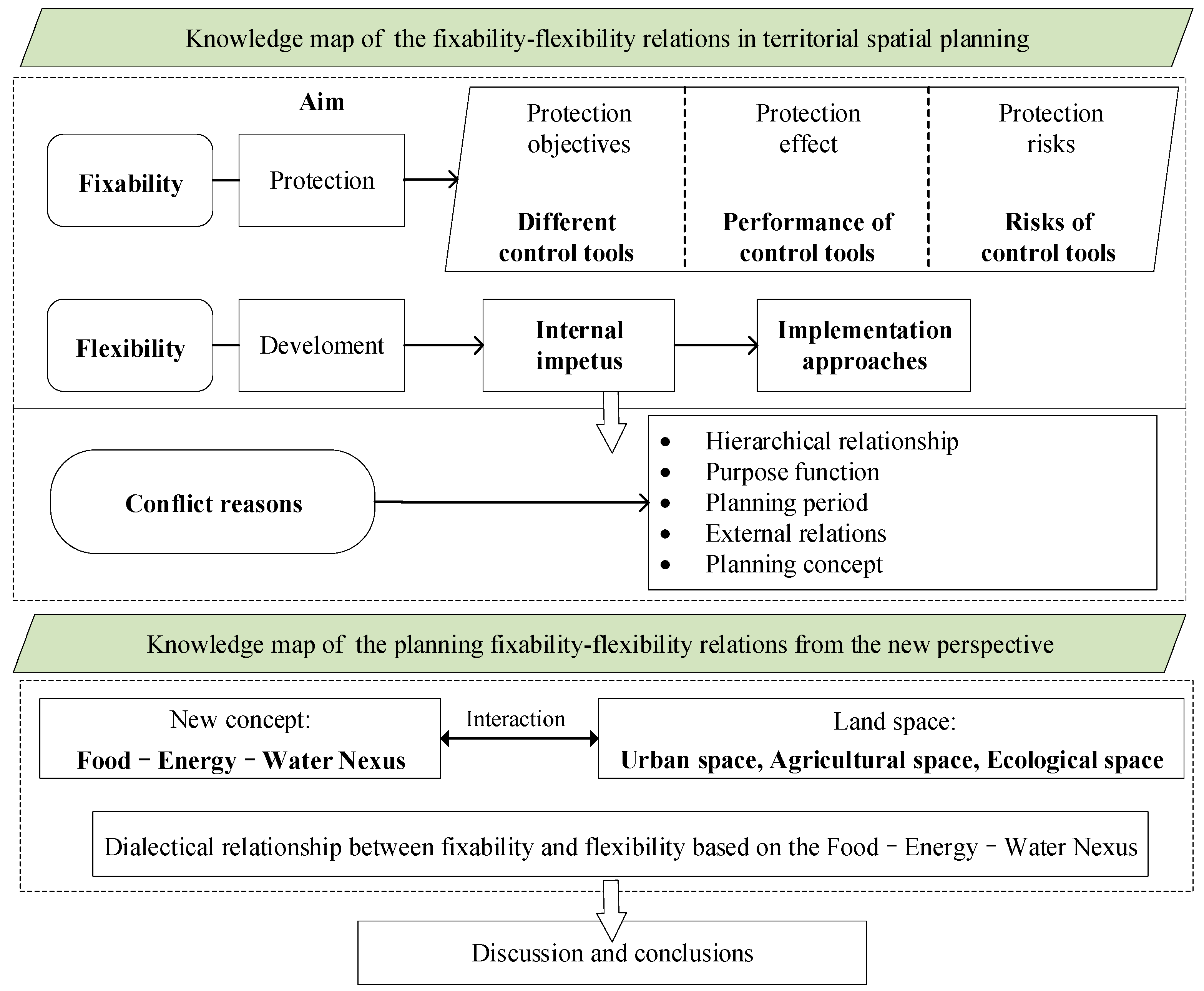
2. Constraints for Protection: Fixability in Territorial Spatial Planning

Since 1987, China has experienced three rounds of quota-oriented land use master planning, generating many positive impacts to coordinate the relationship between the demands of social and economic development, as well as resource and environmental protection, with many tools utilised to control urban construction land expansion, reduce farmland loss and protect important ecological land [6,7]. However, many scholars have expressed critical opinions on the performance and risks of the control tools used in land use planning, noting that urban expansion and farmland protection have not been adequately achieved under the enormous demand from urbanisation and industrialisation [8,9].

2.1. Territorial Spatial Planning Control Tools

Based on the authority provided by the rigidity of the system, quota rigidity, spatial rigidity and usage rigidity play crucial roles in controlling spatial planning, with the aim of promoting the implementation of various planning goals [10]. This paper tries to introduce three types of control tools for territorial spatial planning. They are commonly implemented in China and some are also applied in other countries, including control quotas, boundary management and zoning, from the scale and spatial layout perspectives.
(1)
Control quota
According to the objectives of development and protection in territorial spatial planning, territorial spatial planning quotas are plans for the scale and structure of territorial space that can be implemented and easily evaluated. Under the principles of maintaining the scale of cultivated land, balancing occupation and compensation for cultivated land and planning the overall development of construction land, China has developed and implemented a series of control quotas in territorial spatial planning, including the cultivated land tenure quantity quota, the newly added construction land quota, the newly added construction land occupying cultivated land quota, the cultivated land occupation balance quota and the permanent basic farmland tenure quantity quota1. Control quotas are allocated from the top down in the Chinese planning system, to control the speed and scale of urban expansion and protect the cultivated land and ecological land in terms of land scale. The compilation and execution of subordinate territorial spatial planning must strictly follow the quotas determined by the superior-level territorial spatial planning and be subject to assessment from the superior-level planning at the end of the planning execution period [11]. Similarly, the German Federal Government committed to reducing the conversion from open land to construction land for traffic areas and settlements to within 30 ha in the year 2020, when it was 113 ha in the 2004–2007 period [12].
At the same time, to ensure the orderly and effective allocation of control quotas, governments at all levels need to formulate annual planning quotas and strictly implement them. In practice, overly rigid control quotas strictly limit local governments when they are making urban development and construction arrangements under situations of socioeconomic development, especially when an unforeseen quota demand is encountered, which leads to delays and cancellations in the implementation of projects which require large quotas. On the other hand, a lack of land construction quotas combined with excessive land protection quotas makes it difficult to satisfy the urban expansion demand of local governments, resulting in a lack of motivation to implement socioeconomic development. Local governments in areas with rapid economic development always have to apply for additional land development quotas from governments at the superior-level of spatial planning or use next period’s quotas in advance [13,14].
(2)
Boundary management
The delineation of spatial boundaries that distinguish the types and intensities of land use in different areas is an important policy tool for implementing spatial control. Boundary management refers to the delineation of, the implementation of, the management of and punishment related to the spatial boundaries for certain targets, such as controlling urban expansion and preserving open space. For example, an urban growth boundary (UGB) is established to promote compact and ongoing spatial development patterns by predicting development activities within the boundaries in a period of 10–25 years [15] and suburban boundaries are established to protect suburban land and open space from encroachment [16]. In the early 21st century, the UGB was introduced into China as a planning tool to control disorderly urban sprawl, protect open space and cultivated land, provide public service facilities, improve land use efficiency, guide smart urban growth, etc. [17,18]. There are different types of methods for UGB delineation, such as comprehensively oriented, growth-driven oriented and ecologically constrained oriented methods, with widely used models such as the system dynamics (SD) model, cellular automata (CA) model and GEOMOD model. The SD model performs well in characterising the interactions among different subsystems, such as the economy, society, ecology and land, and in conducting multi-scenario simulations. The CA model is able to simulate the spatiotemporal evolutionary process of complex systems, following a bottom–up simulation approach. The GEOMOD model can be used to simulate the transform of two types of land, such as from non-construction land to construction land, which can be widely used to delineate the UGB. Subsequently, additional control boundary management tools have been derived in China [19,20,21].
For example, the Law of the People’s Republic of China on Urban and Rural Planning (the President of the People’s Republic of China Decree No. 74), promulgated and implemented in 2008, stipulated that urban master plans and township master plans should delineate prohibited, restricted and suitable construction areas; the Guiding Opinions on the Compilation of Overall Land Use Planning at the City, County, and Township Levels issued in 2009 (the Department of Land and Resources No. 51) stipulated the boundary of the urban and rural construction land scale, the boundary of urban and rural construction land expansion and the boundary of prohibited construction land, as well as the formation of four zones: the allowed construction zone, conditional construction zone, restricted construction zone and prohibited construction zone. Boundary control is essentially a licence for land development rights (allowing or disallowing development and construction), and due to the different dominant sectors, different boundaries often cause conflicts regarding the concept and methods used in the delineation and implementation process. The competition for space development rights among different sectors has exacerbated China’s multi-regulatory conflicts and is not conducive to the effective implementation of spatial control. Related studies have focused on the UGB (urban growth boundary), urban–rural construction land expansion boundary, etc., and have recognised that control boundary management is an important policy tool for controlling urban sprawl and guiding urban development, as well as an important means of ensuring food security and ecological protection [22].
If UGBs offer both guidance and control, as noted by some studies [23], then the red lines of ecological protection and the red lines of permanent basic farmland are more stringent control boundaries. In 2005, the Provisions on the Management of the Basic Ecological Control Boundary of Shenzhen City (Municipal Government Decree No. 145) proposed that 49.9% of the city’s total area be designated as the basic ecological control boundary (including concentrated basic farmland protection zones); any unit or individual should strictly abide by the control red line; and other construction activities be prohibited except for the activities of major road transportation facilities, municipal utilities, tourism facilities and parks [24]. In 2014, the initiative of ecological protection red line delineation and management was formally established in the Technical Guidelines for the Delineation of the National Ecological Protection Red Line-Ecological Function Baseline (for Trial Implementation) (the Ministry of Environmental Protection Annex No. 10).
(3)
Zoning
Zoning refers to a tool for dividing different functional areas for development or protection. It is a control technique that originated in the U.S. which divides land into several zone areas where specific activities can occur. The purpose of zoning has shifted from managing land use density and plot ratios to controlling urban size and protecting agricultural land and open space. The comprehensive zoning was first investigated by the New York City Commission on Building Height in the year of 1910. Land use zoning districts are determined and different restrictions are established, such as land use (types of use, public facilities and matching open space), population densities as well as building heights and usages [25].
To date, zoning control is one of the most common tools for controlling land development in the United States, France, Germany and Korea, and it has mixed effectiveness [26,27]. Zones are always related to government authority, which means that governments implement mandatory management of land occupation rights, land use rights and land use behaviour through administrative and planning means. The state applies land use zoning regulations with the help of “dominance” to restrict the right to use land to compensate for the insufficiency of the market mechanism and promote the rational allocation of land resources [28]. Some planners and economists observe that land use zoning control can avoid problems related to land use resource mismatch to some extent. However, others are critical of excessive governmental intervention and pay more attention to flexible market-based instruments such as transferable development rights (TDRs) or tradable planning permits (TPPs) [12]. These instruments are considered to enhance land use efficiency and improve land market vitality to fill the “rigid, out-of-date, and does-not-respect-the-law-of-market” gap in land use control zoning tools [29].
China has already established a comprehensive system of land use zoning regulations, which includes land use territorial zoning, land use zoning control and construction zoning control. For example, in 2010, the State Council issued Development priority zoning (DPZ) (State Council No. 46), specifying most of China’s area as forbidden development zones (FDZs), restricted development zones (RDZs), key development zones (KDZs) and optimised development zones (ODZs) [30].

2.2. Performance Evaluation of Control Tools

Regarding the evaluation of the objectives and implementation of planning, many scholars have proposed evaluation indices of planning effectiveness and performance, such as the control of urban sprawl, the protection of farmland and the rural environments, and protection of natural environments and open spaces [31,32]. Statistically, different cities with or without planning control tools are chosen to estimate the impact on population, employment, tax rate, public transit and economic growth to prove that planning control tools have promoted land use efficiency and public services [33,34]. Additionally, housing prices and land prices inside or outside planning control boundaries are evaluated to research the joint effect of planning control tools [35,36].
However, the results of effectiveness evaluations have been mixed. Although approximately 730,000 hectares of agricultural land have been protected through land development controls in the United States since 2009, studies have shown little evidence that the trading of land development rights can enhance UGB management at the regional level or facilitate the consolidation of other urban open spaces to form contiguous blocks of preserved spaces [37]. While acknowledging the quantitative conservation effects of farmland under planning control, some scholars have gradually shifted to maintaining the continuity of farmland as a means of reducing the operating costs of farms and preserving the ecological integrity of farmland, focusing on the impact on ecological benefits and environmental safety. For example, the spatial performance of planning control tools has been evaluated by comparing the effects of three farmland protection tools, namely, purchase development rights (PDRs), transfer development rights (TDRs), and cluster schemes, on the amount of farmland and the degree of farmland fragmentation [38,39].
In China, currently, planning control objectives are decomposed in a top–down manner in the land use planning system, with the cultivated land, basic farmland protection, construction and newly added construction land occupying cultivated land quotas allocated, and governments at different hierarchical levels should achieve the designed objectives [40]. Based on certain target requirements and expectations, Cai et al. established a planning control performance evaluation index system considering three main aspects: planning effectiveness, planning gap and planning failure [41]. Based on the planning objective, the key to the performance evaluation of territorial spatial planning control tools is to estimate their control effect on conversion from cultivated land to construction land, which focuses on the quantification of cultivated land protection performance [42]. Some studies have shown that China’s territorial spatial planning control system has achieved a balance in terms of the quota of cultivated land which should be protected, with the trend of the conversion of cultivated land to construction land being curbed and the reduction speed and magnitude of cultivated land being controlled [43,44]. Other researchers hold the view that these control tools have little performance contrast with the expected goals [45,46]. Based on the background of institutional changes, as the core goal of China’s territorial spatial control planning has gradually transformed from “farmland protection” to the combination of farmland protection and ecological environment protection, new requirements have been set for establishing an evaluation index system and a model of territorial spatial planning control tools. Especially in farmland protection, more attention has been paid to the quality of farmland and the impact on the ecological environment. However, the current evaluation methods are limited to the coupling of socioeconomic development with cultivated land quantity protection polices, and a coupled evaluation model for socioeconomic development, cultivated land protection and ecological environment has yet to be established, resulting in a biased performance evaluation of planning control tools [47,48].

2.3. Risks of Control Tools

(1)
Regulatory failure
To balance public interests and improve social welfare, planning is an important policy tool used by governments to compensate for market failure and defects. Planning can also cause conflicts related to regulatory failure and inefficiency. For example, society as a whole enjoys the benefits of ecological environment improvement and food security, while environmental activists bear the cost of such protection. A lack of incentive mechanisms leads to the dilemma of “policy failure” and “free riding” [49]. Tan and Qu pointed out that the inefficiency and excessive loss of farmland conversion in China caused by high-speed farmland non-agriculturalisation will lead to social, economic and ecological insecurity [50]. Combining externality with marginal revenue theory, Wu et al. proposed that under situations of market and government failure, basic farmland protection in China has different internal mechanisms [51].
(2)
Operation failure
The game between the central and local governments is a primary reason for the failure of territorial spatial planning operations. For example, in the implementation process, local governments sometimes choose a target replacement strategy, replacing the initial quality protection target with a quantity protection target of cultivated land. They will then replace the control target of the scale of newly added construction land occupying cultivated land with a control target of the total scale of urban and rural construction land. In this scenario, the total grain yield of cultivated land is imbalanced due to the occupation of paddy fields with compensation for dry land, occupying high-quality cultivated land with compensation for low-quality land under the target strategy of local governments. On the other hand, ecological land is constantly developed to compensate for the shortage of cultivated land development, threatening regional ecological environment security and resulting in a deviation between the overall rigid constraint goals of territorial spatial planning and the actual results [52]. With the ongoing development of the sustainable development concept, numerous scholars have begun to explore the scientific nature of planning and control policies related to cultivated land protection from the perspective of sustainable development strategies. The policies for cultivated land protection have not only shifted from quantity to quality but have also added spatial control tools such as basic farmland protection zoning [53].

3. Development as a Driving Force: Flexibility in Territorial Spatial Planning

3.1. The Internal Impetus of Flexibility in Territorial Spatial Planning

The fundamental reason for flexibility strategies with regard to territorial spatial planning lies in the driving mechanism of urban expansion. In terms of supply and demand, some studies argue that urban sprawl is the result of spontaneous behaviour during the development of the market economy. The preference for single-family homes creates a market demand for suburban houses, while the owners of agricultural land who pursue high land price returns increase the supply of agricultural and ecological land. Additionally, the government does not play a regulatory role in this process and even implements corresponding affordable housing plans and tax laws, which laterally promote the land supply [54].
Other studies have focused on systemic drivers such as high economic development (especially the development of the non-agricultural economy), population growth, the urban–rural income gap, transportation and infrastructure development, development zone construction, foreign direct investment, planning policy and functional development of suburban areas [55]. To support regional economic development as well as industrialisation and urbanisation processes, scholars assert that reasonable urban spatial expansion is necessary [56]. Therefore, Yang and Zhang carried out scale prediction of urban spatial expansion through mathematical models combined with spatial simulation by means of spatial analysis to provide a basis for the flexibility of territorial spatial planning [57]. In terms of coping with uncertainty, Wang and Zhang were the first scholars to suggest that China departs from overly rigid planning to more resilient and flexible planning with organic coordination between market regulation and government intervention, after which the idea of elastic planning gradually received more attention [58]. According to Wu and Shao, the rigid planning concept lacks alternatives; thus, it pursues the best and only plan [1]. This single, rigid and deterministic planning theory cannot adapt to the needs of reality, while the uncertainty, irrationality and theoretical flexibility compensate for this defect to a large extent. In planning practice, flexible planning theory is mainly reflected in flexible adjustments of the planning system and planning time sequence, the development of flexible planning policies and multi-objective planning schemes.

3.2. The Implementation Approaches of Flexibility in Territorial Spatial Planning

Based on the implementation approaches, the induced demand for urban spatial expansion will increase with the socioeconomic development, population growth and improvements in living standards. China’s top–down land control quotas and bottom–up urban spatial expansion demand have always caused contradictions, leading to local governments competing for land quotas, which is not conducive to the effective utilisation of China’s spatial resources. In the face of rigid top–down decomposition, flexible measures are often adopted at the lower hierarchies [59]. In the process of practice, China’s local governments have gradually developed a series of flexible strategies to strike a balance between the land demand of local socioeconomic development and the required land protection tasks of hierarchically superior governments, such as the reserved quotas for newly added construction land [60], conditional construction zones and the linkage of urban land taking and rural land giving (LUTRG) [61].
(1)
The reserved quotas for newly added construction land.
The allocation of reserved quotas reflects the flexibility of territorial spatial planning under top–down rigidity. Cheng and Yang divided newly added construction land quotas at county level into quotas for guaranteed priorities, quotas for mobile reservation and quotas for allocation to lower administrative regions [62]. The indicator of quotas for mobile reservation was set up to increase the feasibility of planning, when establishing the allocation model for control quotas. Li noted that although the reserved quotas for newly added construction land have strengthened flexibility, they could lead to structural conflicts among different regions due to the rigid original allocation and management of land control quotas. For example, projects did not land as predicted in the original key development regions with a certain number of quotas left, while in “dark horse” regions, the quotas ran out quickly and the project execution is waiting for quotas [63].
(2)
Conditional construction zones.
Conditional construction zones, which are the area between the urban–rural construction land boundary and the urban expansion boundary, were set up for the spatial layout adjustment of specific cities, towns and villages. Without exceeding the planning control quotas, with the area of conditional construction zones, and completing the rural construction land consolidation tasks of overall land use planning, under such circumstances, local governments can adjust the spatial layout using land with conditional construction zones [64]. To this extent, conditional construction zones have the functions of substituting planning control quotas, promoting the implement of increase–decrease linkage of urban–rural construction land, and implementing additional planning control quotas, which will increase the flexibility of territorial spatial planning and promote its effective implementation.
(3)
Increase–decrease linkage of urban–rural construction land
Increase–decrease linkage of urban–rural construction land is an innovative pattern of land transfer. On the basis of the balance of land use in the project regions, the planned development of urban construction land can increase after the rural construction land is reclaimed into cultivated land for the same scale [65]. This strategy aims to promote the economical and intensive use of construction land and the rational layout of urban–rural land. It also can increase the active area of cultivated land and provide an effective way to meet the demand for urban expansion [66]. The implementation of the pilot policy of increase–decrease linkage of urban–rural construction land has achieved certain results. For the institutional design, the operation of the policy can promote the conservation and intensive use of construction land and the integration of urban and rural development. However, in practice, few regions carried out large-scale pilot projects for additional planning control quotas, and a lot of problems were created during the process, such as ignoring the willingness of farmers and the non-standard distribution of revenue from quota transfer usage [67,68].

4. Reflections on Contradictions: Conflicts and Integration of Fixability and Flexibility in Territorial Spatial Planning

The rigid control of scale and space in territorial spatial planning will force development subjects to improve land use utilisation efficiency and promote the intensive and economical use of spatial resources. At the same time, to ensure the land supply, the urban expansion demand caused by socioeconomic development must be met. In theory, the organic unity of rigid constraints and flexible development can balance the achievements of multiple goals from development and protection, thereby promoting the sustainable development of national land space.
However, during actual operation, there are disconnects between fixable control and flexible governance in territorial spatial planning, causing a variety of conflicts in different dimensions and ultimately resulting in contradictory situations of varying degrees and aspects, such as a lack of construction land quotas with strong social and economic development demands or an excessive development history with stern resource and environmental protection tasks. In summary, there are five main dimensions:
  • Hierarchical relationship: Traditional centralised control system vs. local elastic behaviour. The relationships between planning quota content, scale, punishment, and supervisory ability with government performance assessment standards as well as land financial revenues and political achievement assessment stimulation will further influence the behavioural choices of local governments [69].
  • Purpose function: Positioning of superior planning vs. implementation of subordinate planning. The contradictions between the positioning of superior planning and the implementation of subordinate planning stem from the conflicts between ideal protection goals and the practical development demand of territorial spatial planning [70].
  • Planning period: Fixability of static prediction vs. flexibility of dynamic development. The prediction results guided by different planning perspectives vary and include forecasting results related to food, water resources and land demand; these results can reveal vast differences under relatively static and short-term planning perspectives (usually 10 to 15 years) with dynamic and long-term planning perspectives [61].
  • External relations: Restrictions in the relatively enclosed zone and flexibility in the open zone. The scale of cultivated land is one of the core factors used to measure the food security of “closed” areas, while in open areas, the gap between food supply and demand can be filled through market mechanisms such as foreign trade and inventory [71].
  • Planning concept: Reduction under the protection concept and expansion under the development concept [72].

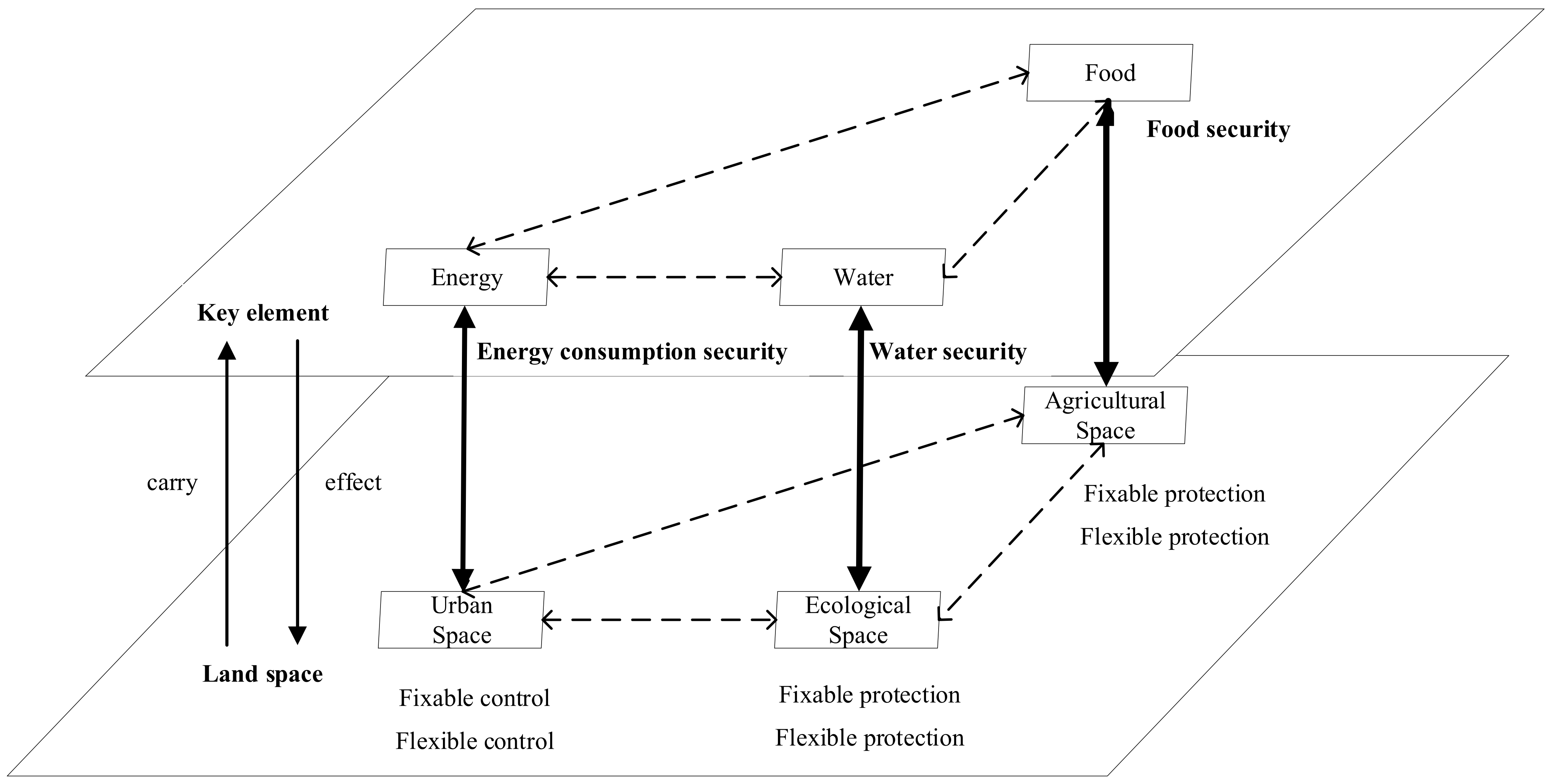
5. Fixability–Flexibility Relations from New Perspective of the Food–Energy–Water Nexus

Based on the Food–Energy–Water Nexus, this paper adopts a dual hierarchical framework (Figure 2) to observe the interaction between the Food–Energy–Water Nexus and land space. The framework includes two system hierarchies: the first is the key element hierarchy and the second is the land space hierarchy. Subsystems interact within the respective hierarchies. In the key element hierarchy, food, energy and water elements not only have coupling relationships in terms of quantity, quality and policy but also have the same goals: the realisation of sustainable development, with the goals of energy consumption security, water security and food security. Related to territorial spatial planning, socio-economic development, food security and ecological protection are the main objectives, and the realisation of these planning objectives depends on the flow and expression of key elements in the land space. In the land space hierarchy, agriculture space, urban space and ecological space interact with each other following the rules of territorial spatial transformation and are affected by fixable and flexible territorial spatial planning tools and strategies, further impacting the energy, food and water elements. The aim is to realize sustainable land space use. This paper focuses on the interaction between the two hierarchies, centring around the relationship of “food security–agricultural space protection”, “energy consumption–urban spatial expansion control” and “water security–ecological space protection”. The details are as follows.

5.1. Introduction of the Food–Energy–Water Nexus

In 2009, the International Atomic Energy Agency (IAEA) analysed the relationships among the elements “climate, land, energy and water” and suggested that any resource policy that focuses on a single resource will have unforeseen negative impacts on other resources. The World Economic Forum released the Global Risks Report in the year of 2011, identified the Water–Food–Energy (W-F-E) Nexus as the three most important risks globally, proposing that food, energy and water security touch on all aspects of the economy, society and the environment [73].
Although the conceptual interpretation of the Food–Energy–Water Nexus has yet to mature in recent years, its interpretation and application have long been widely accepted. Given that the term “Nexus” being used in general to denote the interactions and linkages between two or more things or systems, the Food–Energy–Water Nexus is primarily connected to research on the linkages, synergies and potential conflicts that arise from the way in which the three resources are managed [74,75]. The framework centres on the idea that conclusions drawn from ignoring the impacts of the other two resource systems will have wider consequences and that it is impossible to effectively address food, energy and water security issues in isolation [74,76]. A focus on comprehensively thinking about the trade-offs, interactions and mutual influences among the systems provides a concise expression of the “policy development with clear trade-offs between advantages and disadvantages” idea [77].

5.2. Interaction between the Food–Energy–Water Nexus and Land Space

(1)
Food security and agricultural space protection
Song and Pijanowski emphasised that the quantity and quality of agricultural land are inextricably linked to food security [78]. China’s cultivated land protection has gone through the development process of quantity protection, quantity and quality protection and the trinity protection of quantity, quality and ecology, reflecting changes in the perception of the relationship between cultivated land protection and food security. First, the Land Administration Law of the People’s Republic of China, which went into effect in 1987, explicitly stipulated the relevant provisions on the protection of cultivated land quantity, strictly controlling the occupation of cultivated land. In the 1990s, a dynamic balance system for the total amount of cultivated land was gradually established, and China formally entered the period of cultivated land quantity protection. Second, the Basic Farmland Protection Regulation was implemented in 1999 to further protect cultivated land quality and guarantee national food security [79]. With different statistical and space analysis methods, some scholars have evaluated the effectiveness of cultivated land protection policies in China. On the one hand, they have affirmed that the performance of cultivated land protection policies has reduced the loss of cultivated land resources and has controlled urban expansion. On the other hand, they have suggested that the current cultivated land protection policies are not the most effective means of achieving the food security guarantee goals [80,81,82,83].
Studies have shown that China’s agroecological efficiency is low and that it is significantly negatively correlated with agricultural inputs and agricultural support policies [84]. Issues that pose a great threat to food security include decreasing soil thickness, the organic matter content and nitrogen content of soil, increasing salinisation of cultivated land and the worsening of soil pollution caused by high production intensity and increased use of chemical fertilizers and pesticides. As a result, the central government has further emphasised strategies for protecting cultivated land in terms of quantity, quality and ecology, and it has promoted the construction of a cultivated land rehabilitation system to comprehensively manage food supply security and food safety [85]. The concept of food security has evolved from the original definition of sufficiency, stability and rights, and now involves even greater sustainability [86].
(2)
Energy consumption security and urban spatial expansion control
Some studies have begun to emphasize the correlation between construction land and energy consumption. For example, a logarithmic mean divisia index (LMDI) model was conducted based on construction land, energy consumption, GDP and total population to analyse the contributions of four influencing factors, namely, energy intensity, economic development, population density, and construction land, to the amount of energy consumption growth. The results showed that an increase in construction land drove energy consumption in terms of production and living conditions [87]. Since industrial land has not only a substitution relationship with intellectual capital, but also a complementary relationship with energy physical capital, the rational allocation of land resources will affect the combination of energy, capital, labour and other factor inputs placed on it, as well as the chosen technology [88]. Newman and Kenworthy demonstrated a strong link between population density and energy consumption (gasoline), which implied that low density gives rise to high energy consumption, while high density reduces energy consumption [89]. This trend has led scholars to think about the relationship between “compact” development patterns and sustainable urbanisation. Some scholars have gradually constructed an interactive relationship between urban land use, energy systems and transportation and analysed the impact of urban space morphology on energy demand. Based on the impact of urban space morphology on travel (transportation) distribution patterns, compact cities have an advantage in terms of energy reduction due to the use of public transportation [90].
Urban spatial expansion reflects the increase in the intensity of human activities, the main production and living activities that generate energy consumption, such as construction, industry, and transportation, all contribute to the rapid increase in carbon emissions. Therefore, controlling urban spatial expansion and promoting the extensive use of urban spaces are important measures for reducing carbon emissions [91]. According to the decoupling analysis, in the short term, it is easy to produce a decoupling phenomenon between the rapid expansion of urban space and energy consumption carbon emissions, but in the long term, this trend is more difficult to sustain. Comparing the impacts of urban spatial expansion, wealth growth and technological progress on carbon emissions from energy consumption through the rebound effect, the positive effect of urban spatial expansion and wealth growth on carbon emissions from energy consumption and the emission reduction effect provided by technological progress offset each other. The emission reduction effect is the result of technological progress. Compared with the series of social impacts resulting from wealth reduction, reasonable control of urban spatial expansion will be one of the key measures for scientifically reducing emissions [92].
(3)
Water security and ecological space protection.
Different types of vegetation can change the land surface characteristics, water balance and surface water temperature through water circulation, which will affect the different processes of runoff, groundwater, and receiving waters. Thus, researchers can establish a strong link between land use types and the quantity and quality of water [93,94]. Water quality is most affected by urban land use, and to some extent is influenced by agricultural land [95], while forestland plays a major role in degrading water pollutants [96]. The evaluation of water security and water management measures with the addition of urbanisation factors has made research challenging. The population explosion and expanded urbanisation have altered the state of water security in terms of both demand and supply [97]. On the one hand, water demand and per capita water consumption have increased dramatically; On the other hand, lakes, watersheds and other ecological environments have been transformed into urban spaces, leading to more severe soil erosion. Water resource constraints limit sustainable urbanisation in terms of four aspects: functional, ecological, economic and institutional [98].

5.3. Dialectical Relationship between Fixability and Flexibility in Territorial Spatial Planning Based on the Nexus Thought

Liu et al. summarised relevant studies considering the 17 UN Sustainable Development Goals (SDGs) through a nexus framework and found that the SDGs [99], such as water, energy, food, health, and bio-protection, are all closely related to studies of nexus relationships, especially the nexus of climate [100], land resources and ecosystems [101]. This provides a feasible example for introducing the Food–Energy–Water Nexus perspective to analyse the relationship between rigid control and flexible governance in territorial spatial planning. Food security, energy consumption security and water security are the core of territorial space utilisation and are closely bound to the themes of agricultural space protection, urban spatial expansion control, and ecological space restoration and control, respectively. Considering the dialectical relationship between the Food–Energy–Water Nexus framework and territorial space provides a new way of rethinking fixability and flexibility in territorial spatial planning, of which the key is the coordination among cultivated land protection policy transformation, urban space sprawl control and ecological space rigid control [80,98].
(1)
The integration of fixability and flexibility in territorial spatial planning embodies the dynamic balance relationship between the two poles of objectives of territorial space development and protection.
The fixability and flexibility in territorial space use regulation are reflected in the strength of space control and show the dynamic balance between territorial space development and protection in profile. The foundation for the integration of fixability and flexibility is seeking the optimisation of territorial space patterns under the threshold of the habitat bottom line [2,102]. For example, the “fixability” boundary, which is the red line that cannot be exceeded by urban spatial expansion according to the tenets of the bottom line, is not allowed to be modified in principle and is eternal. The “flexibility” boundary reflects the urban spatial expansion demand at different developmental stages. Under the principle of “stick to the bottom line, keep to the dynamic balance”, a flexible urban development boundary adjustment mechanism that can balance the contradiction between urban development demand and sprawl control tools is key to the integrating fixability and flexibility in territorial spatial planning [103].
First, the protection of agricultural space consisting mainly of cultivated land directly affects the stability of agricultural development. Thus, the current territorial spatial planning determines “the cultivated land quantity” and “the permanent basic farmland protection area” as fixability control quotas based on food security demand, which is an important bottom line related to the supply capacity of regional food resources [104]. Second, the delineation and control of the ecological protection red line, based on the “mountain–water–forest–field–lake–grass” protection system and aimed at ensuring ecological security centred on the water resource cycle, is an ecological bottom line related to the state of satisfying the demand for water resources of the ecological components within the regional ecosystem. In addition, it allows for continuity and the ability to provide clean water to the outside [105]. Third, the expansion demand of construction and industry development from production and living activities in the region, especially in the city centre, is a requirement that must be met to achieve socioeconomic development. However, considering the emission reduction requirements of energy consumption, the space expansion of cities and towns needs to be reasonably controlled [106]. In summary, the integration of fixability and flexibility in territorial spatial planning focuses on the trade-offs and choices between two patterns. One is led by protection-oriented goals centred on cultivated land protection and ecological land protection. The other is led by development-oriented goals centred on socioeconomic development. Flexibility development goals should be based on the realisation of fixability protection goals [60].
(2)
Flexible land use space under fixable constraints is a paradigm innovation for future-oriented planning and implementation.
With the further development and application of flexible theory and planning practice, research has focused on the study of “flexible development zones” (or “flexible spaces”). In theory, since various disciplinary methods have not properly solved the processes and variable problems of connecting humans and space, various models’ ability to explain or predict space development for the expression of the process of national space change is still very limited. Accordingly, to strengthen the flexibility of the development and utilisation of national space, “blank space” should be set up, with the control thinking of territorial spatial planning changing from the “filling all” type to the “framework core” type [2]. The mechanism of blank space consists of a series of flexible land use management practices and mechanisms, mainly in terms of quota, space and timing flexibility, which can support a certain space flexibility for urban development. Specific cases of implementation include the “permitted zone” in Japan, the “blank space” in Singapore, and the “other formulated-use functional zone” in Hong Kong, China. Technically, the land use structure and space layout can be flexibly optimised and configured by combining the interval optimisation model and space analysis methods [107].
Research focuses on determining the “degree” of flexible space, while the logical starting point is the trade-off and coordination among the objectives of food security, socioeconomic development and ecological protection. Taking the protection of cultivated land as an example, the performance evaluation of cultivated land control measures is based on the realisation of food security, rather than the protection effect of the cultivated land quantity, while considering the satisfaction of the urban spatial expansion demand and ecological protection [80]. Based on the dynamic disturbance mechanism of urban expansion on ecological security patterns, Liu and Liu formulated multi-scenario planning programs, evaluated the corresponding landscape ecological risks, and formulated flexible development spaces and strategies based on different development demands [108]. Gu et al. proposed that fixability and flexibility in territorial spatial planning are contradictory opposites; overly rigid planning can make planning too dull, which will decrease the operationalisation and increase the difficulty in planning implementation, thus affecting the function of planning and regulation. In contrast, when planning lacks fixability, the planning rules will be insufficiently mandatory, leading to a significant loss in relation to planning regulations [109].

6. Discussion and Conclusions

The integration of fixability and flexibility in territorial spatial planning has always been a research hotspot. This paper combines relevant research on fixability and flexibility in territorial spatial planning from the perspective of territorial spatial protection and development. After understanding the conflicts of fixability and flexibility, this paper summarizes current research on the dialectical relationship between fixability and flexibility in territorial spatial planning based on the Food–Energy–Water Nexus to provide ideas for research on the integration of fixability and flexibility. The results show as the following:
(1)
Chinese planners and researchers have established a set of theories and tools for integrating the development–protection relations, while those from developed Western countries are not entirely applicable to China.
First, most developed Western countries have successfully achieved high levels of urbanisation and entered a stable stage of urbanisation. The driving force for urban spatial expansion is not as strong as that in developed countries, and most Western countries have relatively stable urban spatial forms, which is significantly different from China’s national conditions, which are still in the process of urbanisation development. Secondly, although some Western countries also implement mandatory planning and control measures to reduce the externalities of spatial development and utilisation, reasonably allocate national spatial resources, and coordinate development and protection conflicts, their national spatial development and utilisation are still mostly dominated by market mechanisms, and the government plays a regulatory and normative role in the scale, structure and layout of national spatial development through planning. At present, as the world’s largest developing country, China still has significant potential for development in industrialisation and urbanisation. There are significant differences in social development and institutions between China and western countries. Therefore, Chinese planners and scholars should innovate an integration system of the fixability–flexibility relations in territorial spatial planning to address the rapid development of urbanisation and industrialisation.
(2)
A more complex and changeable circumstance makes it difficult to grasp the territorial spatial planning control degree (“Du” in Chinese).
Based on the profound interpretation of the concepts of uncertainty and irrationality, numerous Chinese scholars are committed to the dynamic balance between fixability and flexibility. They seek to summarize problems under the two extremes, such as too much fixability or flexibility. In addition, they investigate the integration mechanisms of fixability and flexibility in territorial spatial planning, which are mainly related to the allocation of planning authority between the central and local governments, and they focus further attention on the optimisation of the land use structure and the evaluation of flexible planning in uncertain environments. With further development of the market economy, China will face a more open and uncertain market environment, and the elements of bottom-line constraints and flexible planning will continue to collide, which will cause “traditional-precise” territorial spatial planning to turn into “framework-strategic” planning based on directional concepts [2]. It is necessary to strengthen the analysis of the possibility of future space development and protection, deepen the discussion about the basic path of coordinating rigid control policies with flexible supporting development measures and focus on the delineation and management of the critical control line of the national land space under bottom-line thinking, as well as the optimisation of the scale and layout of flexible space.
(3)
The fragmented goals of territorial spatial planning from a single perspective overlook the complexity and systematicity of the requirements of regional sustainable development.
With the continuous development of computer technology and models, the number of land space optimisation objectives has gradually increased from a single objective function to a multi-objective function and then to the development of high-multi-objective optimisation technology. The optimisation objectives of the scale structure of land space can reach more than 10 objectives for consideration simultaneously. However, planning objectives often appear as fragmented requirements in territorial spatial planning, and the diversity requirements of territorial spatial planning and the correlation between the objectives are not considered. For example, the strictest cultivated land protection system from the perspective of rigid constraints considers only the protection of cultivated land quantity itself, ignoring the negative impact of cultivated land protection policies on ecological land. On the one hand, the trend of decreasing high-quality cultivated land has not been halted. On the other hand, maintaining the dynamic balance of cultivated land through cultivated land development affects regional ecological environmental protection at a deeper level. With the increasing systematicity and complexity of regional development, analysing the correlation between territorial spatial planning objectives from different perspectives as the theoretical basis for the optimising the land space structure and layout will become the focus of future research.
(4)
A unified and complete analytical framework for sustainable development has not yet been formed to explain the dialectical relationship between fixability and flexibility in territorial spatial planning.
The theory, quantitative methods and integrated approach of the Food–Energy–Water Nexus have gradually formed a relatively mature framework for application in sustainable development analysis. However, despite extensive research on the interactions between food, energy, water resources and agriculture, as well as urban and ecological space, most research has focused on three aspects: food security and agricultural space protection; energy consumption security and urban spatial expansion control; and water security and ecological space protection. Research exploring sustainable territorial spatial development and use based on the Food–Energy–Water Nexus is scarce, and the topic is still limited to qualitative research. Few studies have applied the Food–Energy–Water Nexus framework to the construction of land space planning theory and methods; thus, constructing a systematic analysis framework for territorial spatial planning is necessary. The study of the pairwise interactions between food, energy and water resources and agricultural space, urban space and ecological space, as well as the “core” analysis method of the relationships between food, energy and water, will provide a new perspective from which to systematically and comprehensively analyse the integration of fixability and flexibility in territorial spatial planning.
For further study, from the perspective of the Food–Energy–Water Nexus, the integration of fixability and flexibility in territorial spatial planning can be applied to the transformation of fixability and flexibility strategies and tools for realising sustainable territorial spatial utilisation and protection. The three key objectives of sustainable development, namely, food security, energy consumption security and water security, should be related to territorial spatial planning, agriculture space protection, urban spatial expansion control and ecological space protection. Then, the synergistic or trade-off outcomes of different combinations of fixability or flexibility planning tools for agriculture, urban and ecological space should be researched with multi-scenario analysis methods so that the most suitable planning strategies and tools can be chosen.
In practice, the Chinese government should pay attention to all of the key objectives of planning from the “First eat, second development, third preserve environment” planning strategy. In 2019, the General Office of the Central Committee of the Communist Party of China and the General Office of the State Council announced Guiding Opinions on the Coordinated Delimitation and Implementation of Three Control Lines in Territorial Spatial Planning, requested that “the strictest ecological environment protection system, farmland protection system, and land conservation system be implemented”. These systems take the ecological protection red line, permanent basic farmland zoning and urban development boundary as insurmountable red lines for adjusting economic structure, programming industrial development and encouraging urbanisation development. Specifically, local governments were requested to define ecological protection red lines based on ecological functions and implement mandatory and strict protection measures, designate permanent basic farmland zoning in accordance with quality and quantity requirements and implement permanent special protection, as well as define urban development boundaries in accordance with the requirements of intensive, moderate and green development.
To balance the development-oriented planning strategies of local governments with the protection-oriented planning strategies of the central government, this paper claims that the transformation of cultivated land protection policies will become key to the integration of fixability–flexibility relations, based on the “core” analysis thought. Firstly, it is necessary to change the quantity-oriented cultivated land protection system to a quality-oriented system, which means strengthening the rigid control of permanent basic farmland protection zones while weakening the rigidity of cultivated land tenure quantity quotas. Secondly, the local government performance evaluation system should be changed to a comprehensive system, taking the indicators for evaluating the efficiency and intensification of construction land, such as per capita urban construction land, as the priority assessment indicators. At the same time, the flexibility of the newly added construction land quotas should be improved to satisfy development demands. Thirdly, Chinese governments should prioritize the rigid control of ecological protection zoning, the bottom line of ecological environmental security for a country and regions, by prohibiting any land occupation and cultivated land development activities. Moreover, the compensation systems for production function of cultivated land and ecological function should be conducted.
This paper noted that lacking systematic thinking in the drafting and implementation stage is one of the key reasons for the fixability and flexibility conflict issues in territorial spatial planning. Therefore, this paper attempts to explore the application of the Food–Energy–Water Nexus in order to respond to the dilemmas of integration of fixability and flexibility in planning, after considering the relationship between the land space and Food–Energy–Water Nexus. Theoretically, it provides a new perspective from which to think about the integration of conflicts in territorial spatial planning. Practically, it argues about comprehensive and systematic research methods for territorial spatial planning drafting and implementation, because of the trade-offs of different planning tools. In order to promote applications of the Food–Energy–Water Nexus in planning research, case studies exploring the choice of model and simulation are warranted, and these factors should be elaborated on in other studies.

Author Contributions

Conceptualisation, Y.W.; methodology, L.S.; formal analysis, T.Z.; writing—original draft preparation, L.S., C.Z. and Z.T; writing—review and editing, Y.W., L.S., J.S. and L.Z.; visualisation, C.Z.; supervision, Y.W.; project administration, L.Z.; funding acquisition, L.S. and T.Z. and Y.W. and L.Z. All authors have read and agreed to the published version of the manuscript.

Funding

This research was funded by the Humanities and Social Science Project of Ministry of Education of China No. 23YJC630026, the Humanities and Social Science Project of Ministry of Education of China No. 22YJCZH267 and the Major Humanities and Social Sciences Research Projects in Zhejiang Higher Education Institutions No. 2023QN107. This research was also funded by the National Key Research and Development Plan Project of China “Territorial Space Optimization and System Regulation: Theory and Method”, grant number 2022YFC3800800.

Data Availability Statement

Not applicable.

Conflicts of Interest

The authors declare no conflicts of interest.

Note

1
Cultivated land tenure quantity quota refers to the cultivated land area in a region that should be protected. Newly added construction land quota refers to the construction land area that has recently been added to a region. Newly added construction land occupying cultivated land quota refers to the construction land area newly added by occupying cultivated land. Cultivated land occupation balance quota refers to the supplementary area of cultivated land in a region has been requested because of the dynamic balance system of cultivated land. Permanent basic farmland tenure quantity quota refers to the permanent basic farmland area in a region that should be protected.

References

  1. Wu, C.F.; Shao, X.Z. Theoretical study on irrationality, uncertainty and elasticity in land use planning. J. Zhejiang Univ. Humanit. Soc. Sci. 2005, 35, 98. (In Chinese) [Google Scholar]
  2. Wu, C.F.; Tan, Y.Z.; Zheng, H.Y. Territorial Space Use Control; Geology Press: Beijing, China, 2020. (In Chinese) [Google Scholar]
  3. Zhu, J.; Tang, W. Conflict and compromise in planning decision-making: How does a Chinese local government negotiate its construction land quota with higher-level governments? Environ. Urban. 2018, 30, 155–174. [Google Scholar] [CrossRef]
  4. Yue, W.Z.; Wang, T.Y. Rethinking on the basic issues of territorial and spatial use control in China. China Land Sci. 2019, 33, 8–15. (In Chinese) [Google Scholar]
  5. Newell, J.P.; Goldstein, B.; Foster, A. A 40-year review of food—Energy—Water nexus literature and its application to the urban scale. Environ. Res. Lett. 2019, 14, 073003. [Google Scholar] [CrossRef]
  6. Zhou, Y.; Huang, X.; Chen, Y.; Zhong, T.; Xu, G.; He, J.; Xu, Y.; Meng, H. The effect of land use planning (2006–2020) on construction land growth in China. Cities 2017, 68, 37–47. [Google Scholar] [CrossRef]
  7. Su, S.; Jiang, Z.; Zhang, Q.; Zhang, Y. Transformation of agricultural landscapes under rapid urbanization: A threat to sustainability in Hang-Jia-Hu region, China. Appl. Geogr. 2011, 31, 439–449. [Google Scholar] [CrossRef]
  8. Shao, Z.N.; Spit, T.; Jin, Z.F.; Bakker, M.; Wu, Q. Can the Land Use Master Plan Control Urban Expansion and Protect Farmland in China? A Case Study of Nanjing. Growth Change 2018, 49, 512–531. [Google Scholar] [CrossRef]
  9. Zhong, T.; Mitchell, B.; Huang, X. Success or failure: Evaluating the implementation of China’s national general land use plan (1997–2010). Habitat Int. 2014, 44, 93–101. [Google Scholar] [CrossRef]
  10. Liu, H.L.; Nie, J.X.; Luo, M.; Tang, Y.W. Rigid control and soft governance in territorial space planning: A re-examination from the dual perspectives of territorial space and relational space. China Land Sci. 2021, 35, 10–18. (In Chinese) [Google Scholar]
  11. Tan, R.; Beckmann, V. Diversity of practical quota systems for farmland preservation: A multicountry comparison and analysis. Environ. Plan. C Gov. Policy 2019, 28, 211–224. [Google Scholar] [CrossRef]
  12. Henger, R.; Bizer, K. Tradable planning permits for land-use control in Germany. Land Use Policy 2010, 27, 843–852. [Google Scholar] [CrossRef]
  13. Cao, Y.; Zhang, X.; Zhang, X.; Li, H. The incremental construction land differentiated management framework: The perspective of land quota trading in China. Land Use Policy 2020, 96, 104675. [Google Scholar] [CrossRef]
  14. Fang, L.; Tian, C. Construction land quotas as a tool for managing urban expansion. Landsc. Urban Plan. 2019, 195, 103727. [Google Scholar] [CrossRef]
  15. Calthorpe, P.; Fulton, W.; Fulton, W.B. The Regional City; Island Press: Washington, DC, USA, 2001. [Google Scholar]
  16. Watson, D. Time-Saver Standards for Urban Design; Irwin McGraw-Hill: New York, NY, USA, 2003. [Google Scholar]
  17. Wang, W.; Jiao, L.; Zhang, W.; Jia, Q.; Su, F.; Xu, G.; Ma, S. Delineating urban growth boundaries under multi-objective and constraints. Sustain. Cities Soc. 2020, 61, 102279. [Google Scholar] [CrossRef]
  18. Sybert, R.; Poss, D.; Rivasplata, A. Urban Growth Boundaries; Governor’s Office of Planning and Research, Governor’s Interagency Council on Growth Management: Sacramento, CA, USA, 1991.
  19. Lv, Y.; Zhang, S.W.; Yang, J.C. Reconstruct the spatial distribution of land use/land cover in the early reclaimed time of the western Jilin Province—based on the GEOMOD model. J. Anhui Agric. Sci. 2015, 43, 304–308. [Google Scholar]
  20. Yu, X.J.; Shan, L.P.; Wu, Y.Z. Land use optimization in a resource-exhausted city based on simulation of the F-E-W Nexus. Land 2021, 10, 1013. [Google Scholar] [CrossRef]
  21. Li, X.; Yeh, A.G.O. Modelling sustainable urban development by the integration of constrained cellular automata and GIS. Int. J. Geogr. Inf. Sci. 2000, 14, 131–152. [Google Scholar] [CrossRef]
  22. Lin, J.; Liu, W.L. On Delineating the Boundary of Urban Development. Beijing Plan. Rev. 2014, 6, 14–21. [Google Scholar]
  23. Lv, B.; Xu, Q.Z. Discussion on the technical and institutional issues of applying urban growth boundary (UGB) in Chinese. Urban Planning Society of China. In Proceedings of the 2010 China Urban Planning Conference, Shanghai, China, 14–16 October 2010; Chongqing-Publishing House: Chongqing, China, 2020. (In Chinese). [Google Scholar]
  24. Yu, B.D.; Ye, Y.H.; Guo, W.; Yu, L.S.; Huang, T.; Sun, F.F.; Luo, J.W. Research on the partition construction mode for ecological essential line: A case study in Dapeng Peninsula, Guangdong province. Ecol. Environ. Sci. 2014, 6, 962–971. [Google Scholar]
  25. Ervin, D.E.; Fitch, J.B.; Godwin, R.K.; Shepard, W.B.; Stoevener, H.H. Land Use Control: Evaluating Economic and Political Effects; Ballinger Publishing Company: Cambridge, MA, USA, 1977. [Google Scholar]
  26. Nick, G.; Kwang, S.K. Land zoning and local discretion in the Korean planning system. Land Use Policy 2001, 18, 233–243. [Google Scholar]
  27. Salanié, J.; Coisnon, T. Environmental Zoning and Urban Development: Natural Regional Parks in France, OECD Environment Working Papers No. 110; OECD Publishing: Paris, France, 2016. [Google Scholar] [CrossRef]
  28. Cheng, Y.; Wang, J.; Meng, F.H. Research on Land Use Zoning Control; Geology Press: Beijing, China, 2003. (In Chinese) [Google Scholar]
  29. Lai, S.G. A Comparison between development permitand zoning system based on property rights and information economic analysis. Planners 2002, 18, 64–66. (In Chinese) [Google Scholar]
  30. Wu, Y.; Peng, Y.; Zhang, X.; Skitmore, M.; Song, Y. Development priority zoning (dpz)-led scenario simulation for regional land use change: The case of Suichang county, China. Habitat Int. 2012, 36, 268–277. [Google Scholar] [CrossRef]
  31. Bunce, M. Thirty years of farmland preservation in North America: Discourses and ideologies of a movement. J. Rural. Stud. 1998, 14, 233–247. [Google Scholar] [CrossRef]
  32. Pacione, M. Introduction on urban environmental quality and human wellbeing. Landsc. Urban Plan. 2003, 1, 1–3. [Google Scholar] [CrossRef]
  33. Woo, M.; Guldmann, J.-M. Impacts of urban containment policies on the spatial structure of US metropolitan areas. Urban Stud. 2011, 48, 3511–3536. [Google Scholar] [CrossRef]
  34. Li, J.Y.; Jean-Michel, G.; Jian, G.; Hao, S. Urban growth boundaries optimization under low-carbon development: Combining multi-objective programming and patch cellular automata models. J. Environ. Manag. 2023, 340, 117934. [Google Scholar] [CrossRef] [PubMed]
  35. Tan, R.H.; Xu, S.X. Urban growth boundary and subway development: A theoretical model for esti-mating their joint effect on urban land price. Land Use Policy 2023, 129, 106641. [Google Scholar] [CrossRef]
  36. Marin, M.C. Impacts of Urban Growth Boundary Versus Exclusive Farm Use Zoning on Agricultural Land Uses. Urban Aff. Rev. 2007, 43, 199–220. [Google Scholar] [CrossRef]
  37. Stoms, D.M.; Jantz, P.A.; Davis, F.W.; DeAngelo, G. Strategic targeting of agricultural conservation easements as a growth management tool. Land Use Policy 2009, 26, 1149–1161. [Google Scholar] [CrossRef]
  38. Brabec, E.; Smith, C. Agricultural land fragmentation: The spatial effects of three land protection strategies in the eastern United States. Landsc. Urban Plan. 2002, 58, 255–268. [Google Scholar] [CrossRef]
  39. Arendt, R. Basing Cluster Techniques on Development Densities Appropriate to the Area. J. Am. Plan. Assoc. 1997, 63, 137–145. [Google Scholar] [CrossRef]
  40. Tan, R.; Zhou, T. Decentralization in a centralized system: Project-based governance for land-related public goods provision in China. Land Use Policy 2015, 47, 262–272. [Google Scholar] [CrossRef]
  41. Cai, G.K.; He, K.Q.; Xing, G.R. Measurement and evaluation on the efficiency of urban comprehensive planning. Urban Probl. 2013, 8, 6. [Google Scholar]
  42. Zhang, Q.J.; Ou, W.H.; Wang, W.M. Study on cultivated land preservation Performance of land use control system and its regional differences in China. China Land Sci. 2008, 9, 8–13. [Google Scholar]
  43. Zhang, W.; Wang, W.; Li, X.; Ye, F. Economic development and farmland protection: An assessment of rewarded land conversion quotas trading in Zhejiang, China. Land Use Policy 2014, 38, 467–476. [Google Scholar] [CrossRef]
  44. Zhai, W.X.; Huang, X.J. Analysis on the effect of polices operation of cultivated land protection in China. China Land Sci. 2003, 17, 6. [Google Scholar]
  45. Bullock, A.; King, B. Evaluating China’s Slope Land Conversion Program as sustainable management in Tianquan and Wuqi Counties. J. Environ. Manag. 2011, 92, 1916–1922. [Google Scholar] [CrossRef] [PubMed]
  46. Shen, X.; Wang, X.; Zhang, Z.; Lu, Z.; Lv, T. Evaluating the effectiveness of land use plans in containing urban expansion: An integrated view. Land Use Policy 2018, 80, 205–213. [Google Scholar] [CrossRef]
  47. Liang, H.; Ma, X.G. Performance evaluation of land supply institution: From the institutional change perspective. Constr. Econ. 2009, 9, 4. [Google Scholar]
  48. Shen, X.Q. Theory and Method for Measuring the Effectiveness of Spatial Plan: A Case for Guiyang’s Comprehensive Land Use Plan (2006–2020); Zhejiang University: Hangzhou, China, 2017. [Google Scholar]
  49. Cai, Y.Y.; Yu, Y. The restriction of farmers’ land development rights under prime farmland planning control: A case study of Wulijie Town in Wuhan City. China Popul. Resour. Environ. 2012, 22, 76–82. (In Chinese) [Google Scholar]
  50. Tan, R.; Qu, F.T. Inefficiency and excessive loss of farmland conversion in China. China Land Sci. 2006, 20, 3–8. (In Chinese) [Google Scholar]
  51. Wu, M.F.; Ou, M.H.; Li, Y.; Wang, L.M. On the internal mechanism of basic farmland protection under land use planning control. Ecol. Econ. 2011, 12, 5. [Google Scholar]
  52. Guo, Z.; Wu, Y.Z. Research on target substitution in the Implementation of cultivated land protection system based on multi-task agent. Economist 2016, 6, 58–65. (In Chinese) [Google Scholar]
  53. Zang, J.M.; Wang, W.M.; Li, B.J. Policy assessment and improvement of prime farmland protection institution in China. China Popul. Resour. Environ. 2007, 17, 105–110. [Google Scholar]
  54. Li, X.; Qu, F.; Zhang, S.; Wang, Y. Urban sprawl control in China based on international comparison and strategy selection. Trans. Chin. Soc. Agric. Eng. 2011, 10, 10–19. [Google Scholar]
  55. Huang, X.J.; Li, C.G.; Huang, X. The mechanism and regulation pathway of urban sprawl of Changchun. Prog. Geogr. 2009, 1, 9. (In Chinese) [Google Scholar]
  56. Shi, N. Land and space demand for high quality development. Hum. Settl. 2019, 4, 3. [Google Scholar]
  57. Yang, R.N.; Zhang, X.L. On the development of resource industry and the sustainable use of the resources in the mountain area of western Anhui. Areal Res. Dev. 1997, 16, 5. (In Chinese) [Google Scholar]
  58. Wang, W.M.; Zhang, Y. Market economy and land use planning-On the study of planning revision method. China Land Sci. 2003, 17, 9–15. (In Chinese) [Google Scholar]
  59. Zhou, T.; Tan, R.; Shu, X. Rigidity with partial elasticity: Local government adaptation under the centralized land quota system in China. Land Use Policy 2022, 118, 106138. [Google Scholar] [CrossRef]
  60. Zhou, T.; Hu, R. Why the Central government prefers to centralize spatial planning approval authority in China? An explanation based on land risk. J. Environ. Plan. Manag. 2022, 66, 2832–2853. [Google Scholar] [CrossRef]
  61. Yang, J. The Optimization of the Chinese Farmland Conversion Command and Control System’s Governance Structure-the Comparative Study of the Emission Trading System; Zhejiang University: Hangzhou, China, 2014. (In Chinese) [Google Scholar]
  62. Cheng, P.; Yang, Y. County-level urban construction land indices decompose based on gray correlative degree analysis. J. Anhui Agric. Sci. 2010, 2, 14721–14722. (In Chinese) [Google Scholar]
  63. Li, A.G. Good steel used on the blade: A research report on the innovation of construction land reserve management in Wuxi City, Jiangsu Province. Natl. Land Resour. Inf. 2016, 5, 4. [Google Scholar]
  64. Qian, W. Flexible Planning Ideas Used in Land Use Planning Dilemma and Effect in Xishan District, Wuxi City; Nanjing Agricultural University: Nanjing, China, 2014. [Google Scholar]
  65. Yang, Q.L. Discussion on connecting policy between city and county construction land. J. Anhui Agric. Sci. 2007, 35, 536–538. [Google Scholar]
  66. Wang, Y.C. Discussion on the policy of Increase and decrease linkage of urban-rural construction land. Resour. Inhabitant Environ. 2007, 35, 3. [Google Scholar]
  67. Pan, J.J.; Xu, Y.M.; Liang, S. Affecting factors of development and utilization of “Four-wasteland” resources in Hebei Province. Soil Water Conserv. China 2009, 5, 49–50. [Google Scholar]
  68. Liu, Y.; Yang, Y.; Li, Y.; Li, J. Conversion from rural settlements and arable land under rapid urbanization in Beijing during 1985–2010. J. Rural. Stud. 2017, 51, 141–150. [Google Scholar] [CrossRef]
  69. Zhou, T.X. Research on the Land Planning Governance Mode under the Central-Local Relations: Based on the Perspective of Centralization and Decentralization; Zhejiang University: Hangzhou, China, 2018. [Google Scholar]
  70. Jiang, X.J. Research on Geographical Space Optimization in the Context of Ecological Civilization: A Case Study of Gansu Province; Lanzhou University: Lanzhou, China, 2019. (In Chinese) [Google Scholar]
  71. Wu, F.; Mao, D.H.; Wang, H. Virtual land research for the purpose of food security. Sci. Technol. Manag. Land Resour. 2009, 25, 5. [Google Scholar]
  72. Liu, Y.; Fu, B.; Zhao, W.; Wang, S.; Deng, Y. A solution to the conflicts of multiple planning boundaries: Landscape functional zoning in a resource-based city in China. Habitat Int. 2018, 77, 43–55. [Google Scholar] [CrossRef]
  73. World Economic Forum. Global Risks 2011, 6th ed.; World Economic Forum: Geneva, Switzerland, 2011. [Google Scholar]
  74. Laurentiis, V.D.; Hunt, D.; Rogers, C. Overcoming food security challenges within an energy/water/food nexus (EWFN) approach. Sustainability 2016, 8, 95. [Google Scholar] [CrossRef]
  75. Olsson, G. Water, energy and food interactions-Challenges and opportunities. Front. Environ. Sci. Eng. 2013, 7, 787–793. [Google Scholar] [CrossRef]
  76. Biba, S. The goals and reality of the water–food–energy security nexus: The case of China and its southern neighbours. Third World Q 2016, 37, 51–70. [Google Scholar] [CrossRef]
  77. Cairns, R.; Krzywoszynska, A. Anatomy of a buzzword: The emergence of the “energy-food nexus” in UK natural resource debates. Environ. Sci. Policy 2016, 64, 164–170. [Google Scholar] [CrossRef]
  78. Song, W.; Pijanowski, B.C. The effects of China’s cultivated land balance program on potential land productivity at a national scale. Appl. Geogr. 2014, 46, 158–170. [Google Scholar] [CrossRef]
  79. Guo, Z.; Wu, Y.Z. Basic farmland protection system should be priority in dynamic balance system of total arable land. J. Hunan Financ. Econ. Univ. 2016, 2, 54–62. [Google Scholar]
  80. Wu, Y.; Shan, L.; Guo, Z.; Peng, Y. Cultivated land protection policies in China facing 2030: Dynamic balance system versus basic farmland zoning. Habitat Int 2017, 69, 126–138. [Google Scholar] [CrossRef]
  81. He, J.; Liu, Y.; Yu, Y. A counterfactual scenario simulation approach for assessing pact of farmland preservation policies on urban sprawl and food security in a major grain-producing area of China. Appl. Geogr. 2013, 37, 127–138. [Google Scholar] [CrossRef]
  82. Skinner, M.W.; Kuhn, R.G.; Joseph, A.E. Agricultural land protection in China: A case study of local governance in Zhejiang Province. Land Use Policy 2001, 18, 329–340. [Google Scholar] [CrossRef]
  83. Feng, J.; Lichtenberg, E.; Ding, C. Balancing act: Economic incentives, administrative restrictions, and urban land expansion in China. China Econ. Rev. 2015, 36, 184–197. (In Chinese) [Google Scholar] [CrossRef]
  84. Cheng, C.Y.; Ren, J.M.; Wang, R.S. Spatial-temporal distribution of agricultural eco-efficiency in China. Acta Ecol. Sin. 2014, 34, 7. (In Chinese) [Google Scholar]
  85. Wu, Y.Z.; Xu, Z.Y. Study on the transformation of cropland protection under the background of rehabilitation system. Resour. Sci. 2019, 41, 9–22. [Google Scholar]
  86. Pretty, J. Agricultural sustainability: Concepts, principles and evidence. Philos. Trans. R. Soc. Lond. B Biol. Sci. 2008, 363, 447–465. [Google Scholar] [CrossRef]
  87. Bai, X.D. An empirical study of construction land and energy consumption in China. Technol. Dev. Enterp. 2014, 33, 2. (In Chinese) [Google Scholar]
  88. Zhao, A.D.; Lan, J.; Ma, X.L.; Xu, S. The impact of land price marketization on factor input and technology choice in China’s industrial sector. J. Financ. Econ. 2016, 42, 85–96. [Google Scholar]
  89. Newman, P.; Kenworthy, J. Sustainability and cities: Overcoming automobile dependence. Landsc. Urban Plan. 1999, 44, 219–226. [Google Scholar] [CrossRef]
  90. Nakamichi, K.; Seya, H.; Yamagata, Y. Geographically explicit direct/indirect CO2 emission scenarios for a compact city in 2050. In Proceedings of the 10th Symposium of the International Urban Planning and Environment Association (UPE10 Next City), Sydney, Australia, 24–27 July 2012. [Google Scholar]
  91. Xie, K.; Nan, L. Effects of construction land on carbon emissions from energy consumption in Shaanxi Province based on STIRPAT model. Hubei Agric. Sci. 2016, 3, 599–602. [Google Scholar]
  92. Zhang, S.Q.; Chen, Y.R. Correlation effect of city construction land expansion and energy consumption carbon emission. Res. Soil Water Conserv. 2017, 24, 244–249. [Google Scholar]
  93. LeBlanc, R.T.; Brown, R.D.; FitzGibbon, J.E. Modeling the effects of land use change on the water temperature in unregulated urban streams. J. Environ. Manag. 1997, 49, 445–469. [Google Scholar] [CrossRef]
  94. Kuruppu, K.A.U.K. Water Quality Assessment in the Hawkesbury Nepean River System, New South Wales; Western Sydney University: New South Wales, Australia, 2016. [Google Scholar]
  95. Johnes, P.J.; Heathwaite, A.L. Modelling the impact of land use change on water quality in agricultural catchments. Hydrol. Process. 1997, 11, 269–286. [Google Scholar] [CrossRef]
  96. Sliva, L.; Williams, D.D. Buffer Zone versus Whole Catchment Approaches to Studying Land Use Impact on River Water Quality. Water Res. 2001, 35, 3462–3472. [Google Scholar] [CrossRef]
  97. Wang, X.; Zhou, Z.; Li, W.; Jia, Y. Impacts of land use change, water demands and climate change on water circulation of Hun River Basin in northeast China. In Proceedings of the International Conference on Remote Sensing, Environment and Transportation Engineering, Nanjing, China, 24–26 June 2011; IEEE Press: Piscataway, NJ, USA, 2011. [Google Scholar]
  98. Yao, S.M.; Feng, C.C.; Wang, C.X.; Nian, F.H.; Guan, C.M.; Chen, C. China’s Urbanization and Its Resource and Environmental Foundations; Science Press: Beijing, China, 2010. (In Chinese) [Google Scholar]
  99. Liu, J.; Hull, V.; Godfray, H.C.J.; Tilman, D.; Gleick, P.; Hoff, H.; Pahl-Wostl, C.; Xu, Z.; Chung, M.G.; Sun, J.; et al. Nexus approaches to global sustainable development. Nat. Sustain. 2018, 1, 466–476. [Google Scholar] [CrossRef]
  100. Howells, M.; Hermann, S.; Welsch, M.; Bazilian, M.; Segerström, R.; Alfstad, T.; Gielen, D.; Rogner, H.; Fischer, G.; van Velthuizen, H.; et al. Integrated analysis of climate change, land-use, energy and water strategies. Nat. Clim. Chang. 2013, 3, 621–626. [Google Scholar] [CrossRef]
  101. Karabulut, A.A.; Crenna, E.; Sala, S.; Udias, A. A proposal for integration of the ecosystem-water-food-land-energy (EWFLE) nexus concept into life cycle assessment: A synthesis matrix system for food security. J. Clean. Prod. 2018, 172, 3874–3889. [Google Scholar] [CrossRef]
  102. Huang, M.H.; Liu, X.; Wang, Y.S.; Wang, Y.; Yan, F. “Mandatory” and “possibility”: Discussion on “urban master planning” under the background of national territory spatial planning. Urban Dev. Stud. 2020, 27, 7. (In Chinese) [Google Scholar]
  103. Xu, J.Q. The flexibility scale and mechanism of urban development boundary. Planners 2016, 32, 5–9. (In Chinese) [Google Scholar]
  104. Fan, Y.T. Study on the Trade-Offs and Synergies of Land Use Functions in Rapid Urbanizing Regions: A Case Study of Jiangsu Province; Nanjing University: Nanjing, China, 2019. (In Chinese) [Google Scholar]
  105. Fu, B.; Xu, P.; Wang, Y.K.; Peng, Y.; Ren, J. Spatial pattern of water retetnion in Dujiangyan County. Acta Ecol. Sin. 2013, 33, 0789–0797. (In Chinese) [Google Scholar]
  106. Deng, X.L. Evaluation of Sustainable Utilization of Chengdu Land Use Beased on Carbon Emissions; Chengdu University of Technology: Chengdu, China, 2015. (In Chinese) [Google Scholar]
  107. Peng, Y.H. Research on flexible optimization of land use structure in county area of Luoxiaoshan Mountain; Hunan University of Technology: Zhuzhou, China, 2019. (In Chinese) [Google Scholar]
  108. Liu, L.; Liu, S. Flexible planning of regional ecological space for ecological security-A case study of Tengzhou City, Shandong Province. Chin. Landsc. Archit. 2020, 36, 11–16. (In Chinese) [Google Scholar]
  109. Gu, J.R.; Zhu, M.C.; Jiang, L.G.Y.; Wu, X.Y. The effect and dividing of flexible space in territory spatial planning. Chin. J. Agric. Resour. Reg. Plan. 2019, 264, 44–52. (In Chinese) [Google Scholar]
Figure 1. Research process for the literature review.
Land 13 00247 g001
Figure 2. The dual hierarchical framework.
Land 13 00247 g002
Disclaimer/Publisher’s Note: The statements, opinions and data contained in all publications are solely those of the individual author(s) and contributor(s) and not of MDPI and/or the editor(s). MDPI and/or the editor(s) disclaim responsibility for any injury to people or property resulting from any ideas, methods, instructions or products referred to in the content.

