
The Value of Traditional Ecological Knowledge in Stormwater Management: A Case Study of a Traditional Village
Abstract
:1. Introduction
2. Materials and Methods
2.1. Description of the Study Area
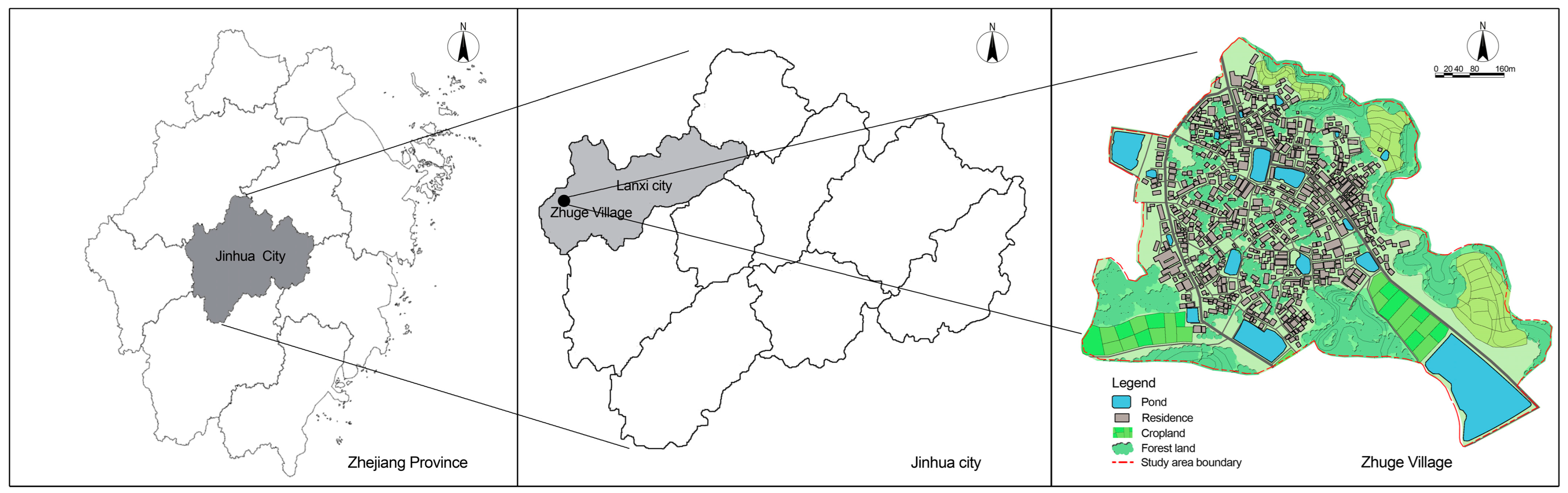
2.1.1. Study Area
2.1.2. Stormwater Management Facilities and Measures in the Study Area
2.2. Data Used
2.3. Research Methods
2.3.1. Establishment of the SWMM
Conceptualization of Regional Drainage Systems in the Research Area
Designed Rainfall
Model Parameter Settings and Calibration
- (1)
- Initial value setting of uncertainty parameters.
- (2)
- Uncertain parameter calibration.
2.3.2. Scenario Design
3. Results
3.1. Total Runoff
3.2. Peak Runoff
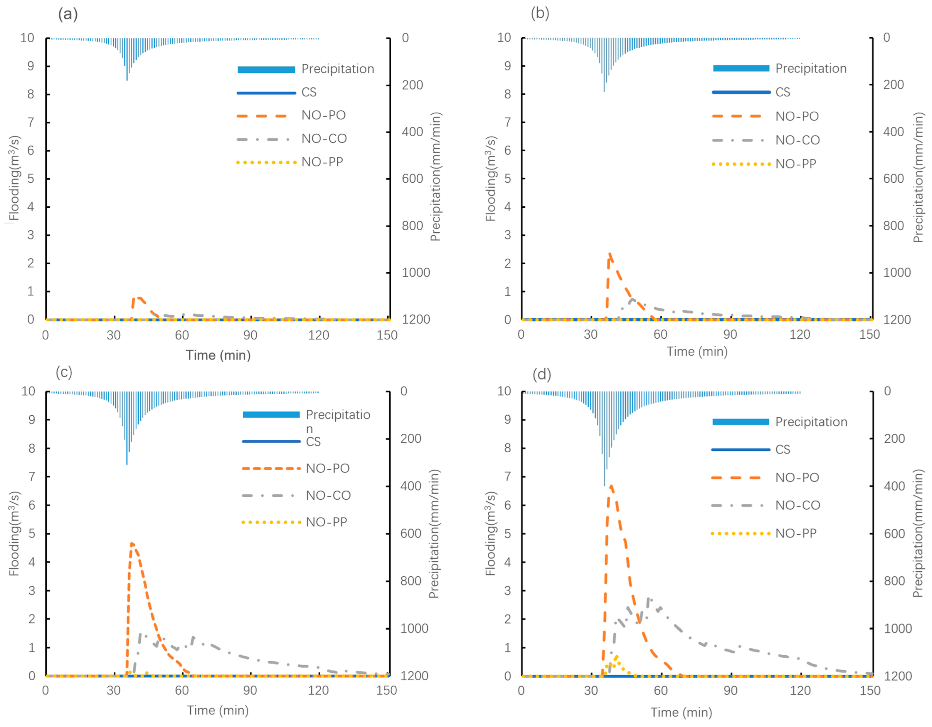
3.3. Flooding
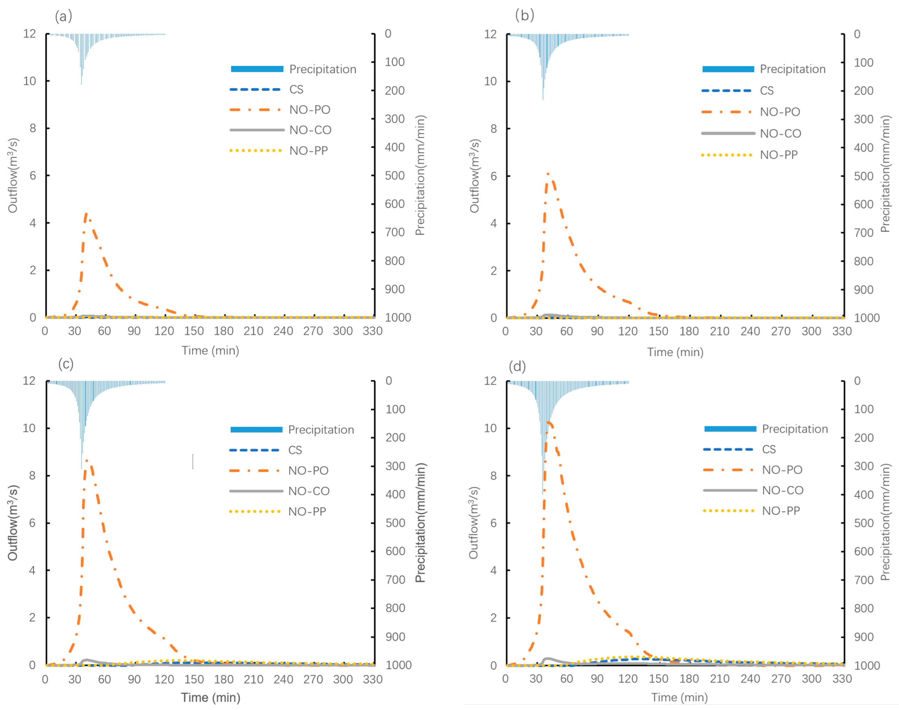
3.4. Outflow
3.5. Storage
4. Discussion
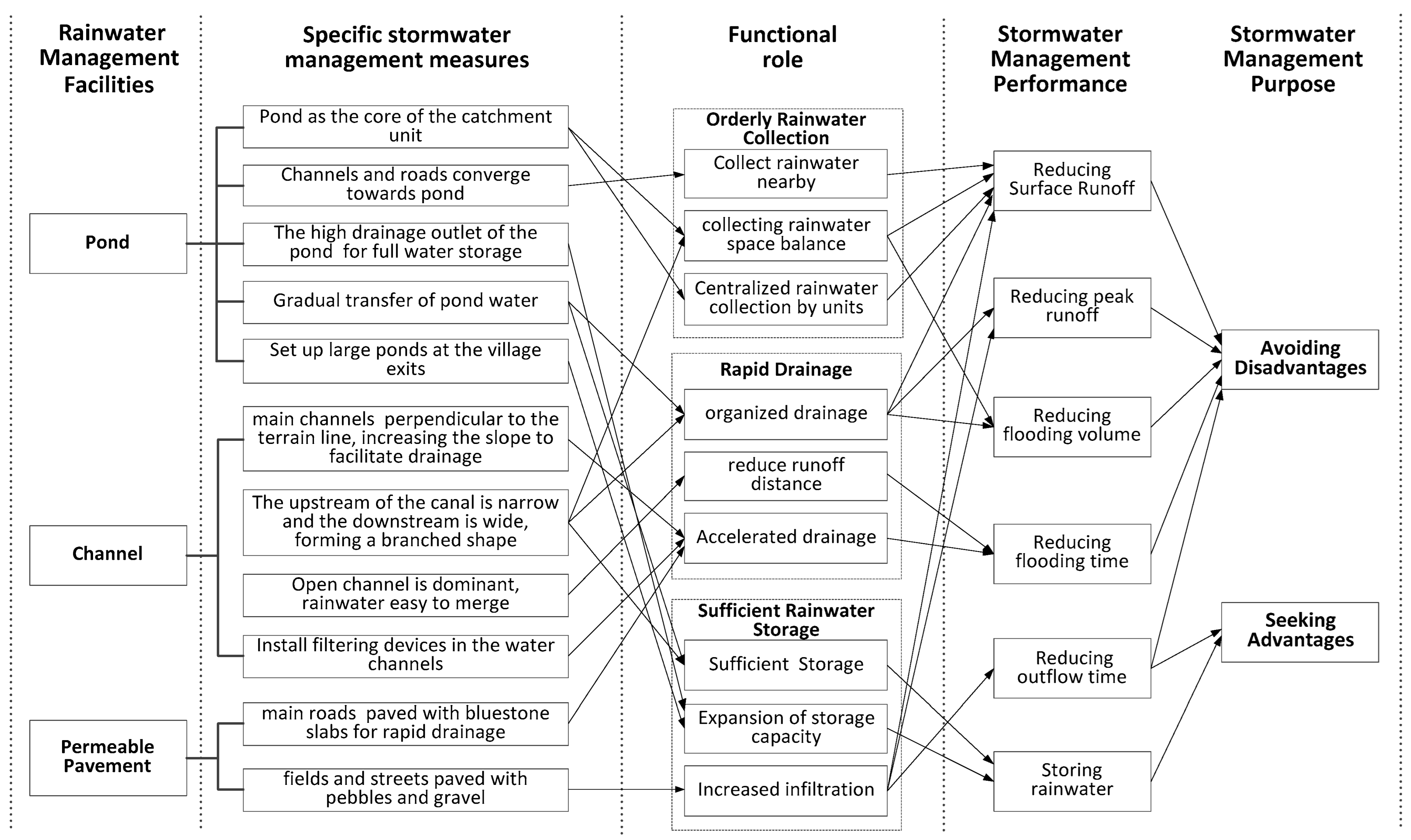
4.1. Function Analysis of Stormwater Management Facilities in Zhuge Village
4.2. Analysis of the Stormwater Management Mechanism in Zhuge Village
5. Conclusions
6. Research Limitations
Author Contributions
Funding
Data Availability Statement
Acknowledgments
Conflicts of Interest
References
- Liew, Y.S.; Mat Desa, S.; Noh, M.N.; Tan, M.L.; Zakaria, N.A.; Chang, C.K. Assessing the Effectiveness of Mitigation Strategies for Flood Risk Reduction in the Segamat River Basin, Malaysia. Sustainability 2021, 13, 3286. [Google Scholar] [CrossRef]
- Qin, H.P.; Li, Z.X.; Fu, G. The effects of low impact development on urban flooding under different rainfall characteristics. J. Environ. Manag. 2013, 129, 577–585. [Google Scholar] [CrossRef]
- Yang, B.; Zhang, T.; Li, J.; Feng, P.; Miao, Y. Optimal designs of LID based on LID experiments and SWMM for a small-scale community in Tianjin, north China. J. Environ. Manag. 2023, 334, 117442. [Google Scholar] [CrossRef]
- Ekmekcioğlu, Ö.; Yılmaz, M.; Özger, M.; Tosunoğlu, F. Investigation of the low impact development strategies for highly urbanized area via auto-calibrated Storm Water Management Model (SWMM). Water Sci. Technol. 2021, 84, 2194–2213. [Google Scholar] [CrossRef]
- Li, Y.; Ye, S.S.; Wu, Q.Z. Analysis and countermeasures of the “7.20” flood in Zhengzhou. J. Asian Archit. Build. Eng. 2023, 22, 3782–3798. [Google Scholar] [CrossRef]
- Ren, S.; Wang, T.Q. Floods Have Affected Nearly 1.29 Million People. Beijing Daily, 10 August 2023. [Google Scholar]
- Liu, H.B.; Gu, X.R. Water Ecological Wisdom and Practice of Traditional Village: Inspiration from Liukeng Village in Fuzhou, Jiangxi for Rural Revitalization. Ecol. Environ. Monit. Three Gorges 2018, 3, 51–58. [Google Scholar]
- Berkes, F. Sacred Ecology: Traditional Ecological Knowledge and Resource Management; Taylor & Francis: Philadelphia, PA, USA; London, UK, 1999; p. 8. [Google Scholar]
- Berkes, F.; Colding, J.; Folke, C. Rediscovery of traditional ecological knowledge as adaptive management. Ecol. Appl. 2000, 10, 1251–1262. [Google Scholar] [CrossRef]
- Hosen, N.; Nakamura, H.; Hamzah, A. Adaptation to Climate Change: Does Traditional Ecological Knowledge Hold the Key? Sustainability 2020, 12, 676. [Google Scholar] [CrossRef]
- Liu, G.D.; Tian, K.; Yuan, X.Z.; Sun, J.F. Traditional Chinese ecological wisdom and its practical meaning: A case study of the river system in Lijiang Old Town. Acta Ecol. Sin. 2016, 36, 472–479. [Google Scholar]
- Xiang, W.N. Doing real and permanent good in landscape and urban planning: Ecological wisdom for urban sustainability. Landsc. Urban Plan. 2014, 121, 65–69. [Google Scholar] [CrossRef]
- Zhang, J.Y. Rural Pond Landscape Design in Zhejiang under the background of New Rural Construction. Master’s Thesis, Shanghai Normal University, Shanghai, China, 2019. [Google Scholar]
- Yang, G.Q.; CAI, Y.F. Natural Wisdom and Social Semantics of Overall Layout of Chinese Traditional Villages. Shanghai Urban Plan. Rev. 2016, 4, 9–16. [Google Scholar]
- Ou, Y.P.; Li, X.L.; Sun, J.Y. Green Human Settlement Construction Based on Water Management in Traditional Villages in Semi-Arid Areas: Taking Laochi in Guanzhong Region as an Example. City Plan. Rev. 2022, 46, 116–124. [Google Scholar]
- Zhou, C.; Cao, P. Contribution and Enlightenment of Ancient Chinese Landscape Architecture and Rainwater Management—Taking Beijing Yuquan Water System as the Example. Chin. Landsc. Archit. 2017, 33, 114–118. [Google Scholar]
- Kong, Y.W.; Cao, S.H.; Jiang, K. Research on Water Management Wisdom of Traditional Villages in Typical Areas of China. In Proceedings of the Industrial Architecture Academic Exchange Meeting, Beijing, China, 14 October 2022. [Google Scholar]
- Min, Z.R.; Huang, P.; Duan, Y.P. Analysis the Wisdom of the Traditional Village’s Drainage System: Taking Liukeng Village in Jiangxi Province as an Example. Urban Dev. Stud. 2018, 25, 7–11. [Google Scholar]
- Wei, C. Research on the Characteristics and Evaluation of Traditional Village Infrastructure; China City Press: Beijing, China, 2017. [Google Scholar]
- Yuan, X.Z.; Du, C.L.; Yuan, J. Multi-Functional dike-pond system adaptive to water level change: Application of pond-based ecological wisdom in ecological restoration of the hydro-fluctuation belt of the Three Gorges Reservoir. Landsc. Archit. Front. 2017, 5, 8–21. [Google Scholar] [CrossRef]
- Zhe, L.; Si, H.; Han, W.; Yan, L. Digital Analysis of the Water Layout Ecological Wisdom in Traditional Chinese Rural Settlements: A Case Study of Liukeng Village in Jiangxi Province. J. Resour. Ecol. 2022, 13, 371–381. [Google Scholar] [CrossRef]
- Palla, A.; Gnecco, I. Hydrologic modeling of low impact development systems at the urban catchment scale. J. Hydrol. 2015, 528, 361–368. [Google Scholar] [CrossRef]
- Li, J.H. Lanxi Yearbook; Zhejiang Ancient Books Publishing House: Hangzhou, China, 2019. [Google Scholar]
- Lin, Q. Study on Water Management Wisdom of Traditional Villages in Jinhua City, Zhejiang Province. Master’ s Thesis, Beijing Forestry University, Beijing, China, 2020. [Google Scholar]
- Rossman, L.; Simon, M. Storm Water Management Model User’s Manual Version 5.2.; U.S. Environmental Protection Agency: Washington, DC, USA, 2022. [Google Scholar]
- Guan, M.; Sillanpää, N.; Koivusalo, H. Modelling and assessment of hydrological changes in a developing urban catchment. Hydrol. Process. 2015, 29, 2880–2894. [Google Scholar] [CrossRef]
- Rossman, L.A.; Huber, W.C. Storm Water Management Model Reference Manual Volume I—Hydrology (Revised); National Risk Management Laboratory, U.S. Environmental Protection Agency: Cincinnati, OH, USA, 2016. [Google Scholar]
- Park, S.Y.; Lee, K.W.; Park, I.H.; Ha, S.R. Effect of the aggregation level of surface runoff fields and sewer network for a SWMM simulation. Desalination 2008, 226, 328–337. [Google Scholar] [CrossRef]
- Campbell, C.W.; Sullivan, S.M. Simulating time-varying cave flow and water levels using the Storm Water Management Model. Eng. Geol. 2002, 65, 133–139. [Google Scholar] [CrossRef]
- Rossman, L.A.; Huber, W.C. Storm Water Management Model Reference Manual Volume II—Hydraulics; National Risk Management Laboratory, U.S. Environmental Protection Agency: Cincinnati, OH, USA, 2017. [Google Scholar]
- Xie, J.; Wu, C.; Li, H.; Chen, G. Study on Storm-Water Management of Grassed Swales and Permeable Pavement Based on SWMM. Water 2017, 9, 840. [Google Scholar] [CrossRef]
- Jang, S.; Cho, M.; Yoon, J.; Yoon, Y.; Kim, S.; Kim, G.; Kim, L.; Aksoy, H. Using SWMM as a tool for hydrologic impact assessment. Desalination 2007, 212, 344–356. [Google Scholar] [CrossRef]
- Xu, H.J. Study of Urban Stormwater Simulation in Typical Area of Nanjing Based on SWMM. Master’s Thesis, Nanjing Normal University, Nanjing, China, 2017. [Google Scholar]
- Li, J.; Li, Y.; Li, Y. SWMM-based evaluation of the effect of rain gardens on urbanized areas. Environ. Earth Sci. 2016, 75, 17. [Google Scholar] [CrossRef]
- Fortunato, A.; Oliveri, E.; Mazzola, M.R. Selection of the Optimal Design Rainfall Return Period of Urban Drainage Systems. Procedia Eng. 2014, 89, 742–749. [Google Scholar] [CrossRef]
- Xu, T.; Jia, H.; Wang, Z.; Mao, X.; Xu, C. SWMM-based methodology for block-scale LID-BMPs planning based on site-scale multi-objective optimization: A case study in Tianjin. Front. Environ. Sci. Eng. 2017, 11, 1. [Google Scholar] [CrossRef]
- Ministry of Housing and Urban-Rural Development of the People’s Republic of China. Standard for Design of Outdoor Wastewater Engineering; China Statistics Press: Beijing, China, 2021. [Google Scholar]
- Yang, Y.; Li, J.; Huang, Q.; Xia, J.; Li, J.; Liu, D.; Tan, Q. Performance assessment of sponge city infrastructure on stormwater outflows using isochrone and SWMM models. J. Hydrol. 2021, 597, 126151. [Google Scholar] [CrossRef]
- Keifer, C.J.; Chu, H.H. Synthetic Storm Pattern for Drainage Design. Am. Soc. Civ. Eng. 1957, 83, 1–25. [Google Scholar] [CrossRef]
- Zhejiang Provincial Department of Housing and Urban-Rural Development. Calculation Criteria of Rainstorm Intensity; China Statistics Press: Beijing, China, 2020. [Google Scholar]
- Liu, X. Parameter calibration method for urban rainfall-runoff model based on runoff coefficient. Water Wastewater Eng. 2009, 35, 213–217. [Google Scholar]
- Horton, R.E. Analysis of runoff-plat experiments with varying infiltration capacity. Trans. Am. Geophys. Union 1939, 20, 693–711. [Google Scholar]
- Liao, Z.L.; Zhang, G.Q.; Wu, Z.H.; He, Y.; Chen, H. Combined sewer overflow control with LID based on SWMM: An example in Shanghai, China. Water Sci. Technol. 2015, 71, 1136–1142. [Google Scholar] [CrossRef] [PubMed]
- Guan, M.; Sillanpää, N.; Koivusalo, H. Assessment of LID practices for restoring pre-development runoff regime in an urbanized catchment in southern Finland. Water Sci. Technol. 2015, 71, 1485–1491. [Google Scholar] [CrossRef] [PubMed]
- Jiang, Y.; Qiu, L.; Gao, T.; Zhang, S. Systematic Application of Sponge City Facilities at Community Scale Based on SWMM. Water 2022, 14, 591. [Google Scholar] [CrossRef]
- Kim, H.; Kim, G. An Effectiveness Study on the Use of Different Types of LID for Water Cycle Recovery in a Small Catchment. Land 2021, 10, 1055. [Google Scholar] [CrossRef]
- Wadhwa, A.; Kummamuru, P.K. A study on the effectiveness of percolation ponds as a stormwater harvesting alternative for a semi-urban catchment. Aqua 2021, 70, 184–201. [Google Scholar] [CrossRef]


| Pond Label | Pond Area (m2) | Pond Depth (m) | Pond Label | Pond Area (m2) | Pond Depth (m) |
|---|---|---|---|---|---|
| 1 | 460.9 | 2.5 | 11 | 1923.2 | 2.7 |
| 2 | 200.7 | 1.9 | 12 | 1267.0 | 2.5 |
| 3 | 202.1 | 2 | 13 | 472.7 | 2 |
| 4 | 3396.3 | 3 | 14 | 383.6 | 2.1 |
| 5 | 351.9 | 2 | 15 | 2040.0 | 2.5 |
| 6 | 2646.4 | 2.9 | 16 | 1157.9 | 2.4 |
| 7 | 237.4 | 2.3 | 17 | 6199.1 | 3.1 |
| 8 | 63.4 | 1.9 | 18 | 27,397.1 | 3.5 |
| 9 | 384.3 | 2.6 | 19 | 5617.0 | 3 |
| 10 | 496.5 | 2.5 |
| Data Type | Specific Parameters | Data Source |
|---|---|---|
| Precipitation data | Precipitation intensity and time | Calculated according to the Lanxi rainstorm intensity formula: where i is the storm intensity (mm/min); t is the storm duration (min); and P is the return period (year) |
| Sub-catchment data | Sub-catchment area and average slope | The sub-catchment area can be calculated automatically in SWMM software version5.2. The average slope of the sub-catchment area is calculated by GIS, according to the elevation data of Zhuge Village |
| Characteristic width | Calculated based on the formula for characteristic width (W): where A is the catchment area, m2; 0.2 < K < 5 | |
| % imperv | According to the statistics of land use status | |
| N-Impervious, N-Pervious, Dstore-Impervious, Dstore-Pervious, and %Zero-Impervious | The initial value is set according to the relevant literature [25,26,27,28], and the final parameter values are determined by calibration | |
| Infiltration data | Max. Infil. Rate, Min. Infil. Rate, Decay Constant, and Drying Time | The initial value is set according to the relevant literature [25,27,29,30,31,32], and the final parameter values are determined by calibration |
| Conduit data | Conduit length, shape, size, inlet offset, and outlet offset | Obtained through relevant information provided by the Zhuge Village Committee combined with on-site measurements |
| Manning’s roughness coefficient | The initial value is set according to the relevant literature [25,27,29,30,31,32], and the final parameter values are determined by calibration | |
| Junction data | Invert elevation, max. depth, initial depth, and surcharge depth | Obtained through relevant information provided by the Zhuge Village Committee combined with on-site measurements |
| Pond data | Pond size And depth, and inlet and outlet Location | Obtained through relevant information provided by the Zhuge Village Committee combined with on-site measurements |
| Topographic data | Elevation topographic map | The Zhuge town government provided a 1:1000 CAD topographic map |
| Land use data | Land use type and area | On the basis of the land use map provided by the Zhuge town government, the land use data were obtained by combining the aerial map with the field survey |
| Sub-Catchment | Area (ha) | Average Slope (%) | Imperviousness (%) | Sub-Catchment | Area (ha) | Average Slope (%) | Imperviousness (%) |
|---|---|---|---|---|---|---|---|
| S1 | 1.48 | 10.8 | 36.93 | S20 | 1.38 | 9.06 | 10.21 |
| S2 | 1.53 | 22.66 | 9.60 | S21 | 1.77 | 10.02 | 28.30 |
| S3 | 0.85 | 5.44 | 40.33 | S22 | 1.78 | 9.5 | 22.83 |
| S4 | 0.42 | 4.65 | 48.96 | S23 | 1.25 | 10.08 | 38.06 |
| S5 | 0.54 | 13.57 | 56.28 | S24 | 0.75 | 11.67 | 38.58 |
| S6 | 0.64 | 15.27 | 50.79 | S25 | 4.42 | 6.68 | 0.00 |
| S7 | 0.93 | 22.59 | 13.89 | S26 | 0.73 | 5.05 | 0.00 |
| S8 | 1.81 | 22.07 | 0.00 | S27 | 0.62 | 0 | 100.00 |
| S9 | 0.35 | 12.64 | 25.55 | S28 | 1.24 | 14 | 24.84 |
| S10 | 1.50 | 12.26 | 37.07 | S29 | 4.12 | 8.61 | 0.00 |
| S11 | 0.62 | 17.64 | 27.13 | S30 | 2.74 | 0 | 100.00 |
| S12 | 1.11 | 19.75 | 15.83 | S31 | 5.97 | 13.31 | 2.97 |
| S13 | 1.46 | 9.55 | 32.96 | S32 | 0.77 | 15.85 | 32.83 |
| S14 | 1.00 | 10.56 | 41.92 | S33 | 0.50 | 5.23 | 60.72 |
| S15 | 0.64 | 14.81 | 44.40 | S34 | 0.73 | 10.72 | 48.32 |
| S16 | 0.25 | 0 | 100.00 | S35 | 0.70 | 3.54 | 3.29 |
| S17 | 0.34 | 0 | 100.00 | S36 | 1.04 | 5.72 | 40.86 |
| S18 | 2.67 | 11.45 | 35.61 | S37 | 0.84 | 6.52 | 17.50 |
| S19 | 1.83 | 6.52 | 33.65 | S38 | 0.57 | 0 | 100.00 |
| Parameter | Initial Value |
|---|---|
| N-Impervious | 0.014 |
| N-Pervious | 0.3 |
| Dstore-Impervious | 1.5 |
| Dstore-Pervious | 5 or 8 |
| Max. Infil. Rate (mm/h) | 76.2 |
| Min. Infil. Rate (mm/h) | 3.81 |
| Decay constant (1/h) | 3 |
| Drying time (day) | 7 |
| N-Conduit | 0.015 |
| Initial Value | First Calibration | Second Calibration | Third Calibration | Fourth Calibration | Fifth Calibration | |
|---|---|---|---|---|---|---|
| N-Impervious | 0.014 | 0.012 | 0.012 | 0.012 | 0.012 | 0.012 |
| N-Pervious | 0.3 | 0.25 | 0.25 | 0.15 | 0.15 | 0.15 |
| Dstore-Impervious | 1.5 | 1.3 | 1.3 | 1.00 | 1.00 | 1.00 |
| Dstore-Pervious | 5 | 3.8 | 3.8 | 2.50 | 2.50 | 2.50 |
| Max. Infil. Rate (mm/h) | 76.2 | 76.2 | 74 | 74.00 | 72 | 71.5 |
| Min. Infil. Rate (mm/h) | 3.81 | 3.81 | 3.81 | 5.00 | 5.00 | 5.00 |
| Decay constant (1/h) | 3 | 3 | 3.00 | 3.00 | 2.9 | 2.9 |
| Simulated runoff coefficient | 0.363 | 0.389 | 0.399 | 0.403 | 0.404 | 0.405 |
| Comprehensive runoff coefficient | 0.405 | 0.405 | 0.405 | 0.405 | 0.405 | 0.405 |
| Area Situation | Comprehensive Runoff Coefficient |
|---|---|
| Areas with the densest buildings (impervious area rate ≥ 70%) | 0.60~0.80 |
| Areas with denser buildings (impervious area rate 30~70%) | 0.45~0.60 |
| Areas with sparse buildings (impervious area rate ≤ 30%) | 0.20~0.45 |
| Type | Parameter | Unit | Parameter Calibration Result |
|---|---|---|---|
| Sub-catchment parameters | N-Impervious | / | 0.012 |
| N-Pervious | / | 0.15 | |
| Dstore-Impervious | mm | 1.00 | |
| Dstore-Pervious | mm | 2.50 | |
| Max. Infil. Rate (mm/h) | mm/h | 71.5 | |
| Min. Infil. Rate (mm/h) | mm/h | 5.00 | |
| Decay constant (1/h) | 1/h | 2.9 | |
| Drying time (day) | day | 7 | |
| Conduit parameters | N-Conduit | / | 0.015 |
| Total Runoff (m3) | Total Runoff Change (%) | Peak Runoff (m3/s) | Peak Runoff Change (%) | Flooding Volume (m3) | Flooding Volume Change (m3) | Flooding Duration | Flooding Duration Change | Outflow (m3) | Outflow Change (%) | Outflow Start Time | Outflow Start Time Change | Storage (m3) | Storage Change (%) | |
|---|---|---|---|---|---|---|---|---|---|---|---|---|---|---|
| CS | 25,275.6 | — | 14.31 | — | 0 | — | 0 | — | 1576.8 | — | The 84th minute | — | 23,681 | — |
| No-PO | 25,284.6 | 0.0% | 14.36 | 0.3% | 3154.2 | 3154.2 * | 29 min | 29 min * | 22,131 | 1303.5% ** | The 1st minute | 83 min earlier ** | 4.5 | −100.0% ** |
| No-CO | 30,508.2 | 20.7% ** | 16.06 | 12.2% * | 4315.2 | 4315.2 ** | 171 min | 171 min ** | 521.4 | −66.9% * | The 13th minute | 71 min earlier * | 20,363 | −14.0% * |
| No-PP | 29,146.8 | 15.3% * | 21.20 | 48.1% ** | 39 | 39 | 3 min | 3 min | 2572.2 | 63.1% | The 63rd minute | 21 min earlier | 26,530 | 12.0% |
Disclaimer/Publisher’s Note: The statements, opinions and data contained in all publications are solely those of the individual author(s) and contributor(s) and not of MDPI and/or the editor(s). MDPI and/or the editor(s) disclaim responsibility for any injury to people or property resulting from any ideas, methods, instructions or products referred to in the content. |
© 2024 by the authors. Licensee MDPI, Basel, Switzerland. This article is an open access article distributed under the terms and conditions of the Creative Commons Attribution (CC BY) license (https://creativecommons.org/licenses/by/4.0/).
Share and Cite
Li, J.; Zhou, W.; Tao, C. The Value of Traditional Ecological Knowledge in Stormwater Management: A Case Study of a Traditional Village. Land 2024, 13, 242. https://doi.org/10.3390/land13020242
Li J, Zhou W, Tao C. The Value of Traditional Ecological Knowledge in Stormwater Management: A Case Study of a Traditional Village. Land. 2024; 13(2):242. https://doi.org/10.3390/land13020242
Chicago/Turabian StyleLi, Jiaxin, Wuzhong Zhou, and Cong Tao. 2024. "The Value of Traditional Ecological Knowledge in Stormwater Management: A Case Study of a Traditional Village" Land 13, no. 2: 242. https://doi.org/10.3390/land13020242