Article

The Impact of Commercial-Industry Development of Urban Vitality: A Study on the Central Urban Area of Guangzhou Using Multisource Data

1
School of Geography and Planning, Sun Yat-sen University, Guangzhou 510006, China
2
China Regional Coordinated Development and Rural Construction Institute, Sun Yat-sen University, Guangzhou 510275, China
3
School of Urban Planning and Design, Peking University, Shenzhen 518055, China
*
Author to whom correspondence should be addressed.
Land 2024, 13(2), 250; https://doi.org/10.3390/land13020250
Submission received: 21 January 2024 / Revised: 8 February 2024 / Accepted: 15 February 2024 / Published: 18 February 2024
(This article belongs to the Topic Urban Land Use and Spatial Analysis)

Abstract

:
Urban commercial centers play a critical role in the development of cities, and it is of significant relevance to research the influencing variables of the urban vitality of commercial centers to improve the quality of urban commercial centers. This study employs big data to construct a multiple linear regression model in order to uncover the spatial-distribution characteristics of urban vitality and commercial sectors in commercial centers within the primary urban region of Guangzhou. The findings indicate that the commercial sectors of life, business, finance, and leisure have a substantial influence on the fluctuation of pedestrian flow in commercial centers throughout the day. Conversely, public service commercial sectors do not have a significant impact on pedestrian flow. Furthermore, the effect of various commercial sectors on the vibrancy of urban commercial centers varies, and their performance differs on weekdays and holidays. Additionally, the level of integration among commercial sectors affects the vitality of the city’s commercial space. This research presents empirical facts that can be used to optimize the logical allocation of urban commercial resources in urban planning.

1. Introduction

As China’s urban planning and construction advances to the stage of stock development, how to promote spatial vitality in limited urban space has become a hot topic in recent years. Conventional urban spatial research is mostly focused on static and materialistic investigations of the physical aspects of the urban landscape, such as the built environment and land-use patterns [1]. As the functional core of the city, with intensive economic activities and active commercial behavior, urban commercial space is usually characterized by having high population concentration and regular changes in urban vitality, and the optimization of its internal functional organization is the most important task in urban construction. In this context, research of the influencing variables of urban vitality in urban commercial centers can allow the relevant departments to improve the quality and vitality of commercial centers and even the whole city, and provide essential references for the development and construction of the city. The study of commercial centers began with the central location idea proposed by Christaller [2], and there have been numerous influential theses. Early study generally originated from the identification of commercial centers, hierarchy, and geographical organization to conduct qualitative research, and the system is relatively developed [3,4,5]. Until the concept of urban spatial vitality was put forward in the 1960s [6], spatial vitality began to be a concern in urban planning, geography, and other fields, scholars focused on exploring the material spatial factors affecting the generation of urban vitality and social environmental factors, such as mixed land use, building density, and urban texture network relationships, etc., proving that all types of built environment in the city will have an impact on the vitality of the region, and then correspondingly they put forward the strategy of optimizing urban vitality [7]. Ian Bentley highlights that locations offering a diverse array of activities are more appealing to individuals compared to those with a singular purpose. Moreover, areas that offer a wide range of activities are preferred by a larger number of people, resulting in a livelier atmosphere [7]. Summia presents that the economic activities of business centers, both locally and regionally, are directly affected by land use, zoning, and traffic policies [8].
The development and appeal of commercial districts are influenced by numerous elements, which have been examined and investigated by the relevant scholars. We can only provide theoretical support for optimizing the building of the relevant regions and boosting their vitality by thoroughly understanding these impacting elements. The retail gravity model, proposed by American scholar Reilly, quantifies the extent of services offered by commercial centers based on the distance between the population of different centers and the center itself [9]. This model reveals that the range of influence of a commercial center is directly proportional to the population size of the center and inversely proportional to the square of the distance between centers. The Huff model, developed by Huff, posits that the appeal of a specific store to customers is determined by two primary factors: the magnitude of the commercial cluster and the proximity to the commercial cluster [10]. Hotelling contends that when there is no price competition (where each firm sets its price equal to the cost of producing an additional unit), the outcome of enterprises maximizing their profits is that each firm gravitates towards the middle of the market [11]. Nevertheless, commercial research in the early years was primarily limited by data and technological constraints. As a result, it heavily relied on the center-place theory and focused on the meso–micro level, specifically examining specific neighborhoods [12,13,14,15]. The characterization of urban vitality was predominantly derived from the researcher’s field records, which resulted in commercial center research being primarily qualitative in nature.
In recent years, the advancement of technology in collecting and analyzing big data has significantly increased the significance of big data in urban geography research. Consequently, numerous scholars have started utilizing big data to conduct extensive research on commercial centers [16,17]. The integration of extensive social perception data and remote sensing pictures will serve as a crucial milestone in advancing the study of urban development [18,19,20,21]. Current research on urban commercial centers utilizing big data mostly concentrates on three key areas: identification of urban commercial centers, analysis of their geographical characteristics, and examination of the spatio-temporal patterns of human activities [22,23,24]. The study of identifying and analyzing business centers mostly relies on urban hotspot data, specifically point of interest (POI) data [25,26]. This type of data offers significant advantages over field research data and economic statistics, including its huge volume, real-time nature, high precision, and wide coverage. Within the framework of POI feature expression, the kernel density approach (KDE) outperforms other density expression methods (such as sample density and density based on Voronoi diagrams) because it takes into account the locational influence described by the first law of geography [27]. Chainey utilized the kernel density analysis technique and the notion of standard deviation curves to quantify the spatial extent of the data’s highest value and effectively identified a concentrated area of criminal activity in the city [28]. This approach has also been employed to identify crime hotspots in urban areas [29].
This approach is employed to verify the urban central business district (CBD) boundary and identify the area with the highest concentration of data values. It prevents extreme values from distorting the overall analysis results, which can occur when using the traditional arithmetic method that is sensitive to local conditions. This method is suitable for determining the spatial location of the polarized central area of the city and is highly important for confirming the boundary. As an illustration, Thurstaon retrieved retail store data using socio-economic statistics and determined commercial hubs by creating a seamless surface of kernel density space using GIS technology [30]. Wu, K. et al. employed 59,125 points of interest (POI) from data within the central region of Guangzhou to establish the limits of commercial centers [31]. They achieved this by utilizing kernel density analysis and integrating it with the existing urban planning of Guangzhou. The objective was to investigate the composition and arrangement of commercial areas in Guangzhou. Regarding the study of urban vitality in commercial centers, researchers have started using big data sources such as mobile phone signaling data, Baidu heat maps, popular reviews, and microblogging check-ins to conduct relevant research [32]. The main focus of this research is to visualize the spatial characteristics of urban vitality, examine the spatial and temporal changes, and analyze the distribution differences among different types of vitality [33]. Researchers utilized the Baidu heat map tool to investigate and analyze the temporal variations in variables such as crowd density, concentration location, and population center of gravity during a continuous week. The central metropolis of Shanghai was chosen as the specific case for this study [34].
The integration of big data with geospatial attributes and quantitative research models has emerged as a prominent trend in recent years [19,29,35]. Significant progress has been made in studying commercial centers using this approach, although some limitations still exist. Firstly, most commercial centers primarily focus on retail [27,36], neglecting the examination of business finance, leisure and entertainment, and other commercial forms. This raises concerns about the scientific rigor and comprehensiveness of the research findings. Secondly, the current research on the factors influencing the urban vitality of commercial centers only considers common factors such as location, traffic, and land-use intensity [37]. Moreover, this research is predominantly qualitative and exhibits a high degree of repetition. Consequently, there is a gap in understanding the impact of the diversity of commercial forms on the vitality of these centers. And, there is a vacuum when starting from the perspective of the mixed degree of commercial activity. Academics and planners have long recognized the importance of mixed land use for urban vitality. However, it remains unclear if different commercial formats have varying effects on the urban vitality of commercial centers, which are known to have the greatest levels of urban vitality in cities. Does a quantitative correlation exist between commercial formats and the urban liveliness of commercial centers? Can the implementation of mixed commercial development have an impact on the vibrancy and liveliness of urban commercial centers?
Therefore, with the help of multisource big data such as Gaode POI and Tencent “Yi Travel”, by focusing on the primary urban region of Guangzhou, this study uses the kernel density analysis technique to pinpoint the urban commercial center, and it analyzes the characteristics of the commercial-mixing degree and urban vitality based on the identification of commercial activity, studies the differences in the influence of different commercial forms on urban vitality, and constructs a model of the relationship between the mixing degree of commercial forms and urban vitality with the aim of quantitatively analyzing the influencing mechanism of the commercial forms of urban commercial centers and urban vitality, with a view to providing empirical evidence for the optimization of the rational allocation of urban commercial resources.

2. Selected Case and Data Sources
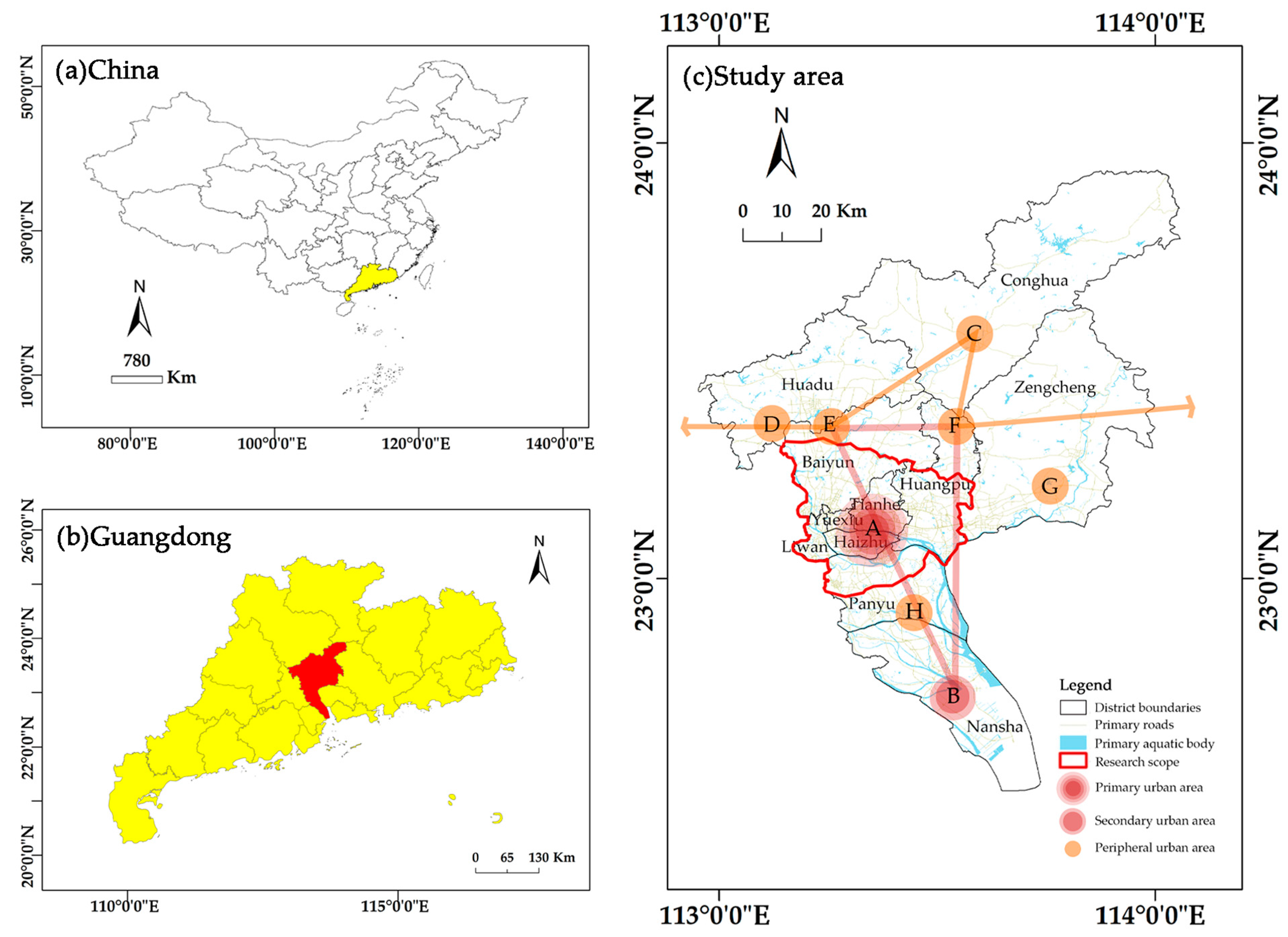
2.1. Selected Case

Situated in southern China, Guangzhou serves as the capital of Guangdong province. It is the central city of the Pearl River Delta metropolitan area and ranked as the fourth-largest city in the nation in terms of GDP in 2023. Guangzhou plays a significant and distinctive role in China’s process of modernization and its engagement with the global community.
The Guangzhou Master Plan (2017–2035), published in 2018, designates the primary urban area of Guangzhou City as encompassing four entire municipal districts: Liwan, Yuexiu, Tianhe, and Haizhu. Additionally, it includes the region located south of the Baiyun North Second Ring Road Expressway, the area south of Whampoa Jiulong Town, and the area north of the Panyu Guangming Expressway (Figure 1). The total land area of this urban region is approximately 1102 square kilometers. Guangzhou City’s major metropolitan area is a highly developed economic region. It boasts well-established commercial facilities and a thriving business environment, making it the central hub for economic, cultural, and comprehensive services in the city. The primary urban region has a high density of land designated for development, a diverse range of land categories, well-developed infrastructure, and thriving economic and social activities. It retains a clear superiority in terms of functioning industries, traffic conditions, and infrastructure setup. Simultaneously, the primary city possesses favorable conditions for advanced development, abundant POI data, and has undergone several stages of urban building and development. Additionally, it encompasses a wide range of business types, making it an excellent specimen for research purposes. Therefore, conducting research on the distribution of commercial centers and the characteristics of urban vitality in the main urban area of Guangzhou City is highly valuable. This research will analyze the relationship between the commercial sectors and urban vitality, aiming to enhance the quality and vitality of the commercial centers. The findings will contribute to improving the efficiency of the city’s commercial operation and service level, as well as promoting sustainable and healthy development of the city’s commerce. Additionally, the research will provide valuable insights for the development of commercial centers in other regions.

2.2. Data and Processing

The primary data utilized in this study mostly consist of Gaode map point-of-interest data (POI) and Tencent’s “Yi Travel” data. The Gaode map point of interest refers to the abstract data points on the map that represent physical surface items. These points have the advantages of being highly precise, providing extensive coverage, and offering powerful real-time information. The Gaode map now holds the highest penetration rate among domestic map applications, and it is the primary commercial map data source utilized by major websites in China. The 2019 commercial point-of-interest data collected in the main urban area of Guangzhou has been reclassified into five categories of commercial businesses, namely, living, business, finance, public services, and leisure, based on the National Economic Industry Classification (GB/T 4754-2011) and the research findings of the relevant scholars [31,38]. Following the process of de-weighting, bias correction, and geographical matching, a total of 159,143 data points of interest were recovered from the study region (Table 1). The actual usefulness of the data was evaluated next, in conjunction with field research sampling.
The city vitality data are obtained from using Tencent’s location of big data service window (https://heat.qq.com/index.php, accessed on 16 June 2019 and 19 June 2019) for Yi Travel data. These data consist of real-time location information captured from active users of Tencent’s series of products, including Tencent QQ, WeChat, space, games, and websites. Due to its large user base and high rate of adoption, it provides a more accurate representation of the current population distribution in the study area [39]. This paper utilizes web-crawler technology to acquire thermal data for the main urban area of Guangzhou City on two specific days in June 2019: 16 June (Sunday) and 19 June (Wednesday). These days are representative of weekends and weekdays, respectively. The thermal data has a spatial resolution of 25 × 25 m and a temporal resolution of 1 h. The 10.6 Arc-GIS software is employed to convert the original CSV format data into point data based on the provided coordinates. Based on the weather data from the Guangdong Meteorological Bureau, the city of Guangzhou is expected to have clear skies and favorable conditions for outdoor activities and commercial operations over the next two days. This ensures that the study’s results are not affected by weather considerations.

3. Research Methodology

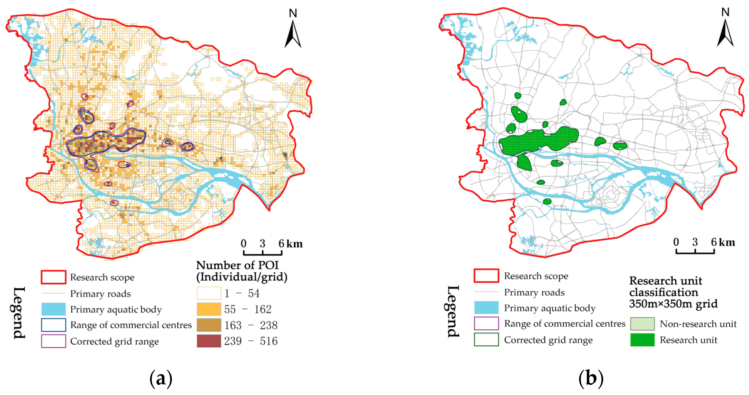
3.1. Commercial Center Identification and Research Unit Division

The kernel density estimation method is commonly employed for detecting urban spatial hotspots. In this study, we utilized spatial distribution data of commercial POI. Initially, we conducted the kernel density analysis using the kernel density tool in map-processing software. A search radius of 1200 m was set [40]. The natural intermittent method was employed to divide the kernel density values into 20 categories. We then compared and observed the smoothness, precision, and clustering patterns of the results across these categories. The initial range of commercial centers is determined by selecting suitable thresholds, and the randomness of agglomeration for the point-of-interest data is tested using the average nearest-neighbor distance index. Based on the information that secondary road intersections in urban road planning are typically spaced 350–500 m apart and research indicating that the optimal walking distance for people in urban environments is 200–300 m [30], the study area is divided into a spatial grid of 350 × 350 m as the fundamental unit. Statistical corrections are then applied to the grid, taking into account the current urban conditions such as road and land use. This process determines the final range of the commercial center in the main urban area of Guangzhou City. Finally, an appropriate spatial grid is selected as the effective basic research unit.

3.2. Relationship Model between Commercial Business Types and Regional Real-Time Pedestrian Flows

Once the fundamental research unit is established, our initial analysis focuses on examining the impact of various commercial sectors on the real-time movement of individuals inside the study area. The regional pedestrian flow is a non-negative integer. After testing for an open root, it follows a normal distribution. The arithmetic square root of the real-time pedestrian flow in the basic research unit is the dependent variable. The independent variable is the structure of the commercial industry. A multiple linear regression model is constructed to analyze the relationship between the commercial industry and the regional real-time pedestrian flow. To comprehend the fluctuation pattern of the influence of various commercial sectors on the liveliness of commercial centers throughout the day, it is imperative to conduct a multiple regression analysis for each hour. This entails establishing a total of 24 distinct multiple linear regression models, denoted as y t 0 , y t 1 ,   y t 2 , …, y t 23 , respectively. The ultimate model depicting the correlation between commercial sectors and real-time pedestrian flow in the vicinity is outlined as follows:
y t i = β 0 + β 1 x 1 + β 2 x 2 + β 3 x 3 + β 4 x 4 + β 5 x 5 + ϵ
Let x 1 ,   x 2 ,     x 3 ,     x 4 ,   and   x 5 denote the quantities of POI in the categories of living, business, financial and public services, and leisure, respectively, inside each basic textual unit.

3.3. Calculation and Modelling of Commercial-Mixing Degree

To conduct a more precise quantitative analysis of the correlation between commercial mix and urban vitality in commercial centers, it is imperative to develop a model that represents the relationship between commercial mix and urban vitality at the fundamental research level of commercial centers. Initially, a dependent variable is created to measure the level of urban vitality, together with an independent variable to measure the extent of business mixing. Additionally, numerous sorts of fundamental independent variables are established.

3.3.1. Classification of the Vitality of Business Center Cities

To measure the urban vitality of the commercial center in Guangzhou, we consider the stability of changes in the flow of people in the main urban area. We aim to accurately reflect the activities of the crowd. To do this, we use the ratio of the average flow of people between 10:00–12:00 and 22:00–24:00 as an indicator of the day–night population ratio. The calculation formula is as follows [41,42].
Day night   population   ratio   A = Average   of   pedestrian   volume   from   10 : 00 12 : 00 Average   of   pedestrian   volume   from   22 : 00 24 : 00
Calculate the threshold value by considering the data features. If A is greater than or equal to 1.1, it is considered daytime active and assigned a value of 1. If A is between 0.9 and 1.1, it is considered all-day active and assigned a value of 2. If A is less than 0.9, it is considered nocturnally active and assigned a value of 3.

3.3.2. The Hill Numbers Diversity Index

This paper utilizes the Hill numbers biodiversity index to quantitatively assess the level of business mixing in commercial centers. The index considers three dimensions: species richness, Shannon entropy, and Gini-Simpson index. These dimensions collectively provide a comprehensive evaluation of the degree of business mixing from three different perspectives. The biodiversity index is commonly employed as a metric to assess the extent of land mixing in urban and rural planning, as well as in land-use studies. Its computation method is as follows:
D   q ( i = 1 s p i q ) 1 / ( 1 q )
The symbol p i reflects the frequency at which species i occurs, whereas q = 0 represents the order of diversity, which indicates how sensitive the diversity index is to both common and rare species. When q = 0 , D   0 i = 1 s p i 0 , the diversity index is insensitive to all species. At this point, the diversity index represents species richness, which reflects the diversity of the business. When q = 1 , D   1 exp ( i = 1 s p i ln ( p i ) ), the diversity index is equal to the power index of Shannon entropy, indicating the level of disorder in the distribution of commercial business. When q = 2 , D   2 1 / ( i = 1 s p i 2 ) , the diversity index represents the Gini-Simpson concentration index, which measures the degree of agglomeration of the same type of commercial business. A smaller index value indicates a lower degree of agglomeration and a higher level of mixing.

3.3.3. Commercial Format

Given that the ratio of each type of Point of Interest (POI) to the total number of POIs provides a more accurate representation of the business sector’s structure, we used a ratio of lifestyle, business, finance, public services, and leisure POIs to the total number of POIs in the study unit as the independent variable; they are denoted as x ratio 1 ,     x ratio 2 ,     x ratio 3 ,   x ratio 4 ,   and   x ratio 5 respectively.

3.3.4. Population Base

The population base within the basic research unit is a crucial determinant of urban vitality [37,43]. It has been observed that the population undergoes minimal fluctuations between 2:00 a.m. and 5:00 a.m. within a day, and the standard deviation during this time period is relatively small compared to other time periods. Hence, the population base, represented by the variable x p , is determined by calculating the average real-time population data between 2:00 and 5:00 a.m.
The relationship model between the degree of commercial format mixing and the urban vitality of commercial centers may be constructed based on the three types of variables mentioned above, and inside the fundamental research unit. This work utilizes unordered multiclassification logistic regression to establish a relationship model between the commercial format and urban vitality, as there is no apparent sequential association among the three urban vitality groups described in this study. The conclusions of this paper are drawn by looking at the regression coefficients of each independent variable in the model.

4. Results

4.1. Identification and Spatial-Distribution Characteristics of Commercial Centers in the Main Urban Area of Guangzhou

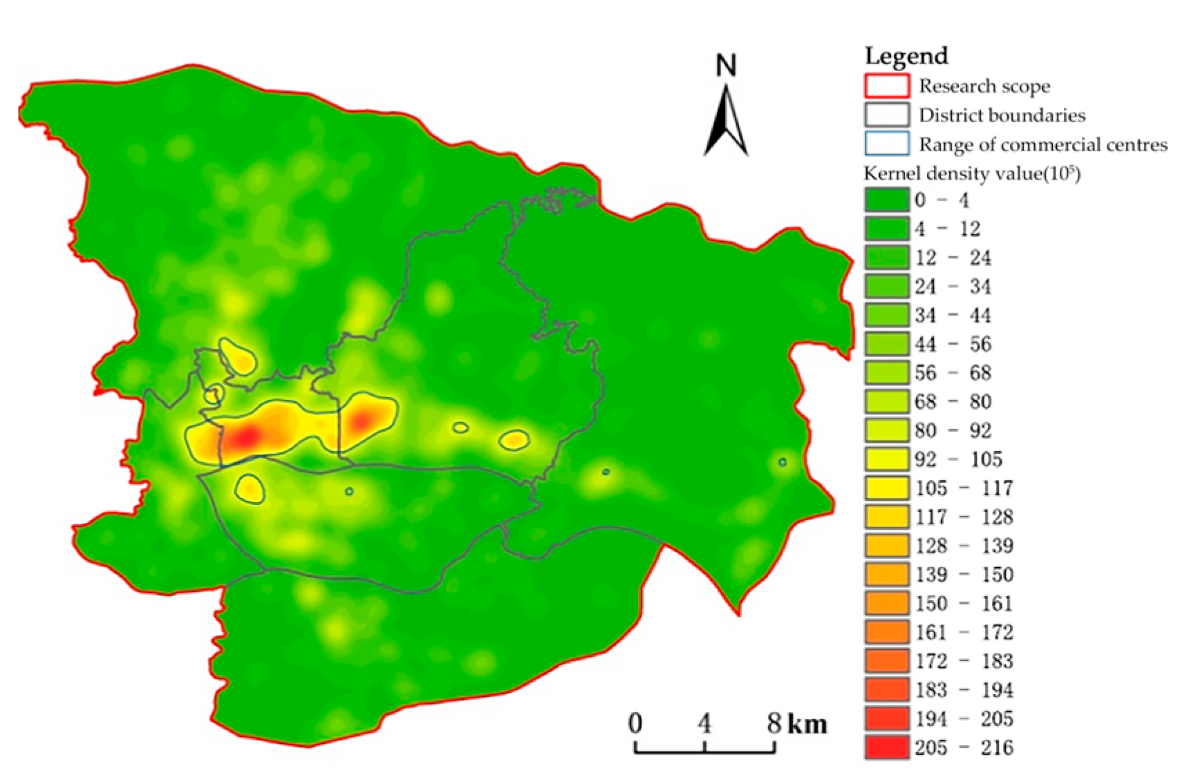
4.1.1. Business Center Identification Based on Business Points of Interest

A kernel density analysis was conducted on commercial points of interest data in the primary urban area of Guangzhou using the kernel density tool available in map-processing software. The search radius for kernel density analysis was set at 1200 m. The kernel density values ranged from 0 to 21,864,368, and were divided into 20 categories using a natural intermittent grading method. By comparing the smoothness, fineness, and agglomeration status of the results against certain thresholds, it was determined that there were nine closed areas with kernel density values greater than 9,200,000, which were identified as commercial agglomeration distribution areas. This served as the initial result for identifying the range of commercial centers (Figure 2). We entered all the collected data on commercial points of interest for the average nearest-neighbor distance index test. The results show that the commercial points of interest in the urban area of Guangzhou are highly clustered, with a p-value score close to zero. This indicates that the clustering pattern observed in the main commercial center of Guangzhou is highly unlikely to occur randomly, with a probability of less than 1%. The randomness test for the aggregation of commercial points of interest data has been successfully passed. After dividing the preliminary range of commercial centers into a grid with dimensions of 350 × 350 m, the statistical threshold for commercial interest points in each grid cell ranges from 1 to 516. These cells are then divided into four levels using the natural intermittent grading method. It has been observed that grid cells with a statistical value of commercial interest points greater than 238 mostly fall within the identified range of commercial centers. Any errors in the initial grid cell statistics are corrected by adjusting the results through addition, elimination, or scaling.
Upon including a limited number of mistakes and inconsistencies, we derived the updated range of commercial centers using the grid cell statistics (Figure 3a). Due to the spillover impact of nuclear density analysis, which contradicts the actual urban morphology structure, the limit of the commercial center is adjusted by taking into account the current state of roads, rivers, mountains, and land. This paper primarily examines the quantitative relationship between commercial factors and urban vitality. The incomplete spatial grid may be attributed to the limited number of points of interest and low population density, which makes the data unreliable and leads to unstable trends. After a careful analysis, 435 research units were selected as the effective basic units (Figure 3b). These units include a total of 66,131 points of interest, with the life, business, financial, public services, and leisure categories accounting for 62.03%, 21.37%, 6.08%, 10.05%, and 0.47%, respectively.

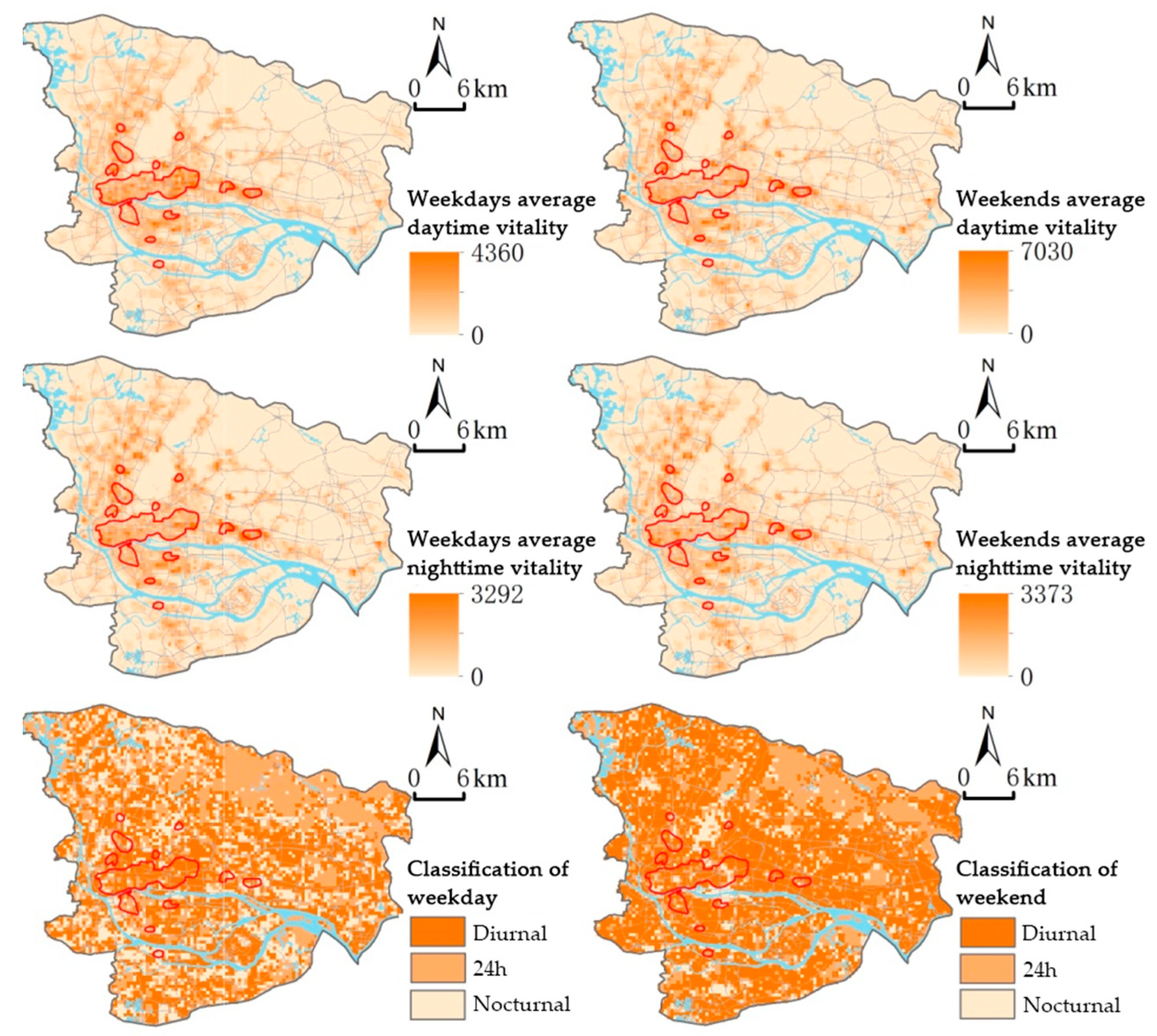
4.1.2. Distribution Characteristics of Urban Vitality

In Guangzhou, urban vitality is primarily characterized by the combination of an “East–West Ridge + North–South Ridge” and “flattened polycentricity + peripheral microcenters” (Figure 4). The regions exhibiting significant liveliness are primarily located in the Tianhe and Yuexiu districts. Additionally, there is a notable concentration of vibrant places around the Airport Expressway, Panyu Avenue, and Guangzhou Avenue, which are also highly populated. High-vitality areas exhibit greater concentration during daytime and rest days compared to weekdays. Within commercial centers, high-vitality areas are scattered in a fragmented manner on weekdays, whereas on rest days they are primarily concentrated in specific locations such as the Tianhe and Haizhu districts. One possible explanation for this phenomenon is that during weekdays, a larger number of individuals go to work in the highly developed commercial districts, such as the Tianhe District. On their days off, they tend to reside in neighborhoods with more affordable housing options that are located at a specific distance from the city center. During weekdays, individuals like to spend their time in the city center. However, on their days off, they prefer to reside in residential neighborhoods that are located at a considerable distance from the city center. This choice is influenced by the more affordable housing rates in those places. This characteristic is also evident in the distribution of urban liveliness at nighttime on weekdays and weekends when commercial hubs exhibit reduced pedestrian activity at night and significantly increased spatial liveliness in their vicinity compared to daytime spatial liveliness on weekdays. Upon categorizing urban spatial vitality into daytime, all-day, and nighttime, it becomes evident that the majority of areas in the main urban region exhibit daytime vitality. Conversely, nighttime vitality is more likely to occur on weekdays and is more widely distributed compared to other days. The likelihood of experiencing all-day active and night-active urban-vitality types is higher on rest days compared to weekdays within commercial centers.

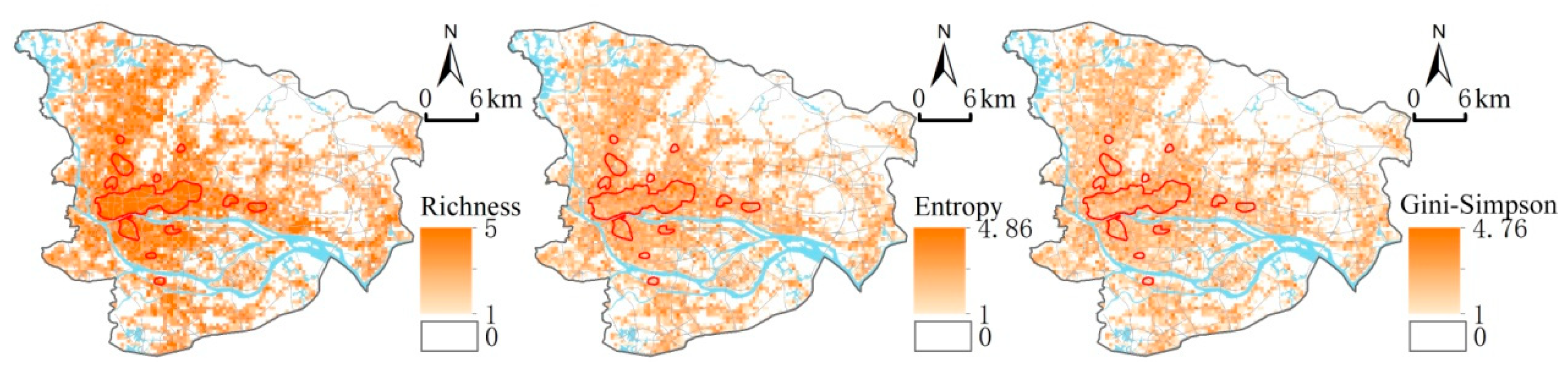
4.1.3. Distribution Characteristics of Commercial Format Mix in Spatial Dimension

The spatial distribution patterns of the mixed degree of commercial factors in the key metropolitan districts of Guangzhou exhibit similarities to the spatial distribution patterns of urban-vitality kinds (Figure 5). As urban vitality increases, the diversity of commercial sectors becomes more abundant, the distribution becomes more chaotic, and the degree of aggregation decreases. Nevertheless, variations in the distribution features of each mixing index persist. The figure illustrates that the main urban area of Guangzhou predominantly consists of five types of commercial businesses, such as life and business, with a high abundance level of 5. However, the vegetation-covered areas located further away from the city center lack any commercial facilities. Conversely, the entropy and Gini-Simpson indices exhibit greater variability between commercial and non-commercial centers, and generally fall towards the lower end of the spectrum.

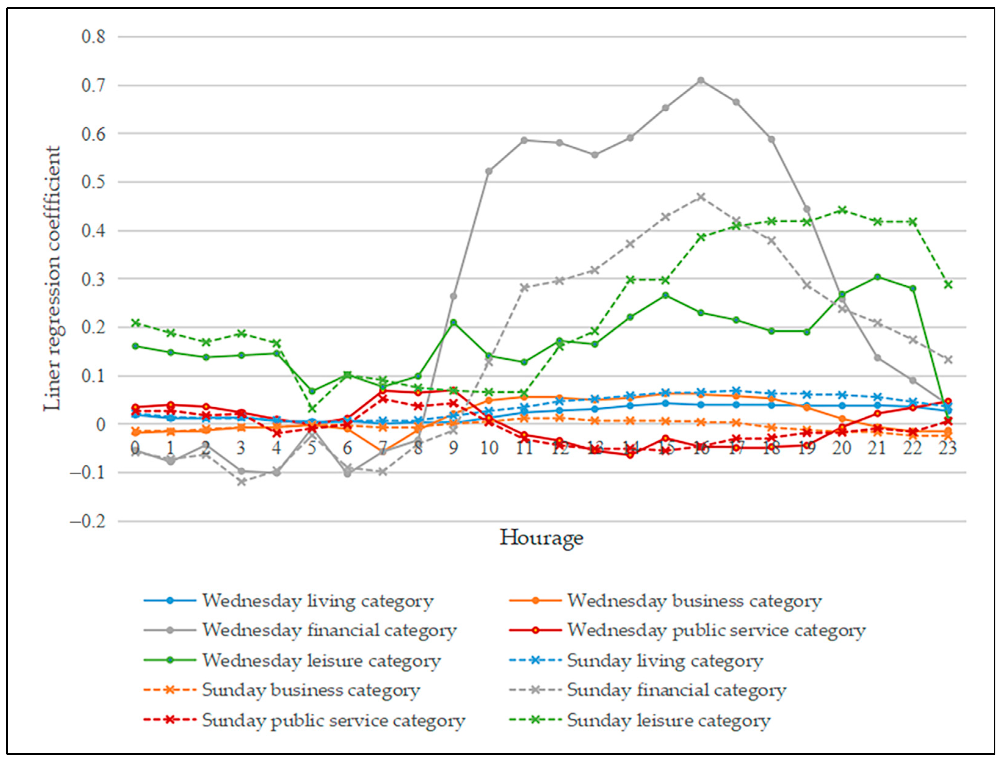
4.2. Real-Time Analysis of Commercial Formats and Regional Pedestrian Flows

A multiple linear regression analysis was conducted, using Wednesday to represent weekdays and Sunday to represent weekends. The 48 multiple linear regression equations are evaluated sequentially using a covariance analysis. Each coefficient has a tolerance greater than 0.7 and a variance inflation factor less than 2. The covariance of the five types of commercial-business POIs is relatively weak, indicating a stable model. Additionally, the significance of the 48 regression equations is approximately 0, satisfying the significance test. The results of the final regression model can be found in Table 2. There is a 95% confidence level that there is a significant linear relationship between the real-time pedestrian flow in the area and different classes of people. The business class shows a stronger significance during weekdays and as does the pedestrian flow. However, the significance is lower during the rest of the day. The financial class shows stronger significance between 9:00 and 21:00, while the leisure class shows higher significance during nighttime. On the other hand, there is a lack of a significant linear relationship between the public service class and the real-time pedestrian flows in the area. It is not believed that these two variables are significantly linearly correlated.
The influence of individual commercial sectors on the real-time movement of pedestrians within the commercial center fluctuates throughout the day (Figure 6). The commercial-business lifestyle primarily consists of a variety of shops, catering establishments, and service facilities that cater to the daily shopping and consumption needs of residents. It serves as a crucial element for attracting pedestrian flows to the commercial center. The presence of life-class commercial businesses, whether on weekdays or weekends, plays a significant role in attracting people to the commercial center throughout the day. This leads to a substantial increase in pedestrian flows, making the urban commercial center more vibrant. This positive impact is particularly noticeable during the afternoon and evening, when the pedestrian flow reaches its peak. Generally, life-class commercial businesses have a greater impact on enhancing the vitality of the city on weekdays compared to other commercial businesses. The afternoon and evening hours are when lifestyle businesses have the greatest positive influence on urban vitality. Upon analyzing the regression coefficient of the business category, it is evident that the business category has a positive impact on pedestrian flow during weekdays in the daytime. This effect remains consistent and gradual.
However, after 7 o’clock in the evening, the coefficient decreases rapidly, slightly suppressing the pedestrian flow. On weekends, the business category has almost no effect on the pedestrian flow. This suggests that the interest points of companies and other businesses within the commercial-business category can enhance the spatial vitality of the area on weekdays. Financial establishments primarily concentrate in urban cores and exhibit a more fluctuating influence on local pedestrian traffic compared to other industries. They significantly enhance urban liveliness during daytime and nighttime, reaching their peak at around 4 p.m. However, they slightly diminish regional footfall after midnight, mirroring patterns observed in the business sector. In general, the financial sector exhibits greater activity on weekdays, particularly Wednesdays, compared to weekends and holidays. A major percentage of company clients in the financial sector rely on physical stores, which necessitates a considerable workforce. Consequently, industry plays a crucial role in enhancing the liveliness and vibrancy of urban areas that serve as commercial hubs. The leisure business sectors have a substantial impact on pedestrian flows throughout the day and contribute to the liveliness of urban spaces, particularly during evening hours. This effect is more pronounced compared to other business sectors, with peak activity occurring in the afternoon and evening. Regression analysis indicates that people have a stronger preference for leisure establishments on their days off compared to weekdays.

4.3. Analysis of the Relationship between Commercial Mix and Urban Vitality

The previous study established a relationship model between commercial sectors and real-time pedestrian flows in a specific region using multiple linear regression. By analyzing the partial regression coefficients of various commercial sectors and their daily trends, it was determined that the sectors of living, business, finance, and leisure were the main factors contributing to significant changes in real-time people flow within a day in the commercial center. Due to the limited number of leisure POIs found within commercial centers, which make up only 0.47% of the total POIs, only the living, business, and financial categories were selected for a further analysis regarding the correlation between the level of commercial-sector integration and urban vitality. When building the unordered multiclass logistic regression model, three types of Hill numbers diversity indexes were included in the model. As a result, three models were created, each with a different model structure. In all three models, the nighttime active type was used as the reference category.
Logit ( π 1 π 3 ) = α 1 + β 11 x r a t i o 1 + β 12 x r a t i o 2 + β 13 x r a t i o 3 + β 14 x p + β 15 x i Logit ( π 2 π 3 ) = α 2 + β 21 x r a t i o 1 + β 22 x r a t i o 2 + β 23 x r a t i o 3 + β 24 x p + β 25 x i
In the formula, i = richness, entropy, and Gini-Simpson;   π 1 ,     π 2   and   π 3 represent the probability of occurrence of daytime-active, all-day-active, and nighttime-active urban vitality, respectively.
Following the test, the independent variables of the model must pass the covariance test. The parameter estimates of the model are presented in Table 3, with the nighttime active type as the reference type. It can be seen that the three models in the reaction to the commercial sector’s mixing degree, using the Hill numbers diversity index’s significant level, basically meets the test of significance, and the Nagelkerke R2 value of each model can be seen to be working; for day, the overall model fitting effect is better, and as a whole the working day model three was the most successful and can be listed in the expression as follows.
Logit ( π 1 π 3 ) = 25.952 + 23.484 x ratio 1 + 26.639 x ratio 2 + 39.285 x ratio 3 0.014 x p + 3.399 x Gini Simpson Logit ( π 2 π 3 ) = 18.725 + 16.919 x ratio 1 + 16.685 x ratio 2 + 16.122 x ratio 3 0.005 x p + 2.348 x Gini Simpson
The model’s overall goodness of fit is low due to the fact that the urban vitality characteristics of urban commercial centers are influenced by a combination of regional economic, cultural, transportational, and other factors. However, this paper primarily focuses on the impact of the commercial-business structure. Given that the primary objective of the study is to investigate the correlation between the variables and not to forecast the urban vitality category, the analysis is conducted solely on weekdays for illustrative purposes. The model results indicate that variations in commercial-business attitudes have a discernible influence on the vibrancy of urban commercial centers during weekdays. Increasing the prevalence of nighttime-active commercial businesses relative to daytime-active ones dramatically reduces the likelihood of daytime-active commercial spaces. However, there is only a slight rise in the likelihood of all-day-active commercial spaces, which is not statistically significant. The probability of the all-day-active type occurring is 1.528 times higher than the probability of the night-time-active type occurring. Thus, the likelihood of having commercial spaces that are active throughout the day is higher when there is an increase in the overall wealth of commercial businesses.
Simultaneously, augmenting the disarray of commercial-business dispersion greatly enhances the likelihood of midday-active and all-day-active commercial areas compared to midnight-active ones. When other factors are taken into account, each 1-unit increase in the disorder of commercial-business distribution leads to a 7.973 times higher probability of daytime-active occurrence and an 11.325 times higher probability of all-day-active occurrence compared to the probability of nocturnal-active occurrence. Additionally, the probability of all-day-active occurrence is 1.409 times higher than the probability of daytime-active occurrence (calculated using the formula e(2.419−2.076) = 1.409). Therefore, as the disorder in the distribution of commercial businesses increases, the likelihood of the all-day-busy type of commercial space occurring also increases. Likewise, decreasing the clustering of similar commercial establishments compared to the nighttime-active establishments greatly enhances the likelihood of midday-active and all-day-active establishments appearing. Increasing the level of aggregation of similar commercial enterprises, specifically from 2.348 to 1.489, leads to a higher chance of daytime-active commercial space. Furthermore, according to the data presented in the table of resultant parameters, the population base successfully meets the criteria for statistical significance in all three models for weekdays. Additionally, increasing the population base of the area will lead to a higher likelihood of nighttime-active commercial spaces compared to daytime-active and all-day-active types.
To summarize, the study found that increasing the disorder of regional commercial business and reducing the aggregation degree of the same business significantly increases the likelihood of the all-day-active type and the daytime-active type. Specifically, increasing the disorder of a commercial business is more favorable for the occurrence of all-day-active types, while reducing the aggregation degree is more favorable for the occurrence of the daytime-active type. In conclusion, the model’s results can be summarized as follows: The diversified growth of its business sector can enhance the vibrancy of a city’s commercial landscape. The outcomes of this modeling experiment align with previous discoveries in the literature.

5. Discussion

5.1. Commercial Format and Residents’ Activity Pattern

Numerous academics have examined and analyzed the behaviors of city dwellers [44]. According to some scholars, residents’ activities can be categorized into two types: daily essential activities and daily non-essential activities [45,46]. Daily essential activities refer to residents’ regular and frequent behaviors like commuting, going to work, and studying. On the other hand, daily non-essential activities encompass temporary and occasional behaviors such as holiday travel and social activities. Most individuals exhibit a daily activity pattern characterized by engaging in work during the daytime and resting during the nighttime, mostly influenced by physiological considerations and work habits. From a commercial perspective, the fixed working hours have a significant impact on the financial and business sectors. Residents are required to be present at their respective workplaces or business establishments during these hours. As a result, there is a substantial increase in the number of people commuting between 9:00 and 18:00, followed by a sharp decline on weekends compared to weekdays. During weekends, there is a substantial rise in the number of individuals engaged in leisure and lifestyle industries, resulting in a more evenly distributed overall activity duration.
The study’s overall conclusions about the influence of commercial format mixing on urban vibrancy align with the concept of a land-use mix [47,48,49]. Jane Jacobs contends that a highly desirable street should have consistent occupancy throughout the day. She asserts that the key to achieving this is by properly integrating essential urban amenities and distributing people’s commuting activities evenly over all hours of the day [6]. This approach is believed to have significant positive effects on both the social and economic aspects of a city. The many sorts of businesses described in this research can be understood as the distinct fundamental and blended functionalities analyzed by Jane, and the findings of this study strongly align with this significant thesis. Mixed land use is a fundamental aspect of new urbanism and sustainable urban development. Grant provided a comprehensive explanation of the theoretical development of mixed land use and supported it with real-life examples [50]. Jacobs-Crisioni C focused on Amsterdam as a case study and developed a model that establishes the relationship between different types of land use, the structure of land mix, and the intensity of residents’ activities [43]. The study concluded that increasing density and the degree of mixing can extend the amount of time residents spend engaging in activities. By the end of the 20th century, urban planners largely acknowledged that including a variety of land uses might result in efficient urban development, enhance human interaction, boost urban vibrancy, and promote sustainable urban growth [51]. The inclusion of mixed-land-use development provides valuable insights into the integration of various types of commercial enterprises and confirms the findings of this study, as it has a comparable influence on pedestrian movement.

5.2. Recommendations for Implementing Effective Tactics in Commercial Center Planning

If the agglomeration benefit theory, central place theory, and land gradient theory are primarily focused on analyzing the economic aspect of planning commercial centers [2,45,52], then modern commercial planning should also consider the social perspective, which encompasses the integration of social function, urban culture, crowd experience, and urban history. Urban planners can utilize the findings derived from the research presented in this paper to inform the revitalization of historic cities, the development of new cities, and the establishment of retail centers in urban planning, with the aim of attaining favorable economic and social outcomes. The mixed development of various commercial sectors can have an impact on the liveliness of urban commercial space [53]. Therefore, urban planners can offer theoretical support for urban construction and management by considering the distinct vitality characteristics of different commercial sectors. To ensure a balanced pedestrian flow throughout the day in urban areas with significant differences in activity levels between weekdays and weekends, it may be beneficial to introduce additional functions during periods of low activity. For instance, the Shangxiangjiu neighborhood, which is primarily active at night, could incorporate commercial activities related to finance and leisure to enhance the utilization of the space throughout the day. Similarly, for commercial neighborhoods that experience a concentrated influx of people within a short timeframe, such as the Tianhebei district, appropriate measures should be taken. For commercial neighborhoods that experience rapid crowd concentration, such as Tianhebei, it is advisable to reduce the level of concentration of the same type of businesses while diversifying the types of commercial establishments. This will enhance the long-term sustainability of crowd activity. However, it is crucial to strengthen crowd control and management during peak periods. In the planning and development of newly constructed commercial neighborhoods, it is recommended to introduce a variety of commercial businesses and carefully coordinate their layout to prevent excessive concentration of similar types of establishments. This approach will contribute to the overall liveliness of neighborhoods. In the development of commercial neighborhoods, it is crucial to consider not only urban traffic, parks, green space, and other factors that affect the liveliness of a city, but also the level of integration of commercial sectors [54]. This aspect should be included in the planning and construction process and should not be overlooked.

6. Conclusions

This study aims to assess the extent of commercial centers in the primary urban region of Guangzhou. It utilizes kernel density analysis and correction techniques to analyze data from five different types of commercial POIs in the area. Additionally, the study examines the variations in the impact of each commercial sector on the characteristics of urban vitality, with the assistance of population big data. Furthermore, a relationship model is constructed to establish a correlation between the urban vitality of commercial centers and the level of integration among commercial sectors. This model provides evidence of the influence of the degree of mixing of commercial sectors on the urban vitality of commercial centers. The following points were found:
(1)
The living, business, financial, and leisure business sectors are the most important sectors affecting the change of pedestrian flow in the commercial center during the day, while the public service business sectors do not have a significant effect on the change of pedestrian flow.
(2)
There is a difference in the influence of different business sectors on the urban vitality of the commercial center during the day: the living business sectors significantly promote the urban vitality of the urban commercial center, and the business and financial business sectors have a positive effect on the pedestrian flow during the day, but inhibit the pedestrian flow in the commercial center at night, and the leisure type of commercial business has a significant stimulating effect on the pedestrian flow throughout the day and is more conducive to the nighttime vitality of an urban space.
(3)
On the whole, the mixing of various commercial businesses has a more significant effect on the urban vitality of a commercial center on weekdays compared to rest days.
(4)
Compared to commercial centers that are active at night, increasing the variety of commercial forms and reducing the concentration of the same type of businesses can significantly increase the likelihood of having businesses that are active all day and during daytime. Diversifying the range of commerce is especially advantageous for 24 h business activity, whilst minimizing concentration is particularly useful for promoting daytime business activity. The mixed development of commercial forms can also impact the vibrancy of urban commercial spaces in a city.
This paper focuses on downtown Guangzhou as the subject of research. It utilizes big data analysis to generate more precise research findings compared to traditional surveys. Additionally, it conducts a comparative analysis of the influence of various commercial sectors on urban vitality. This analysis aims to enhance our understanding of the optimal arrangement of different commercial sectors in the central areas of large cities.
Nevertheless, this study is still subject to certain limitations due to the constraints of data acquisition. The analysis of urban vitality in commercial centers presented in this paper relies on Tencent travel data. Due to its reliance on the spatial distribution of Tencent app users, the Tencent travel data only reflect the population distribution in each time period based on the number of people using the app. As a result, they can only provide an approximate representation of the population’s spatial-distribution density and cannot be considered accurate data for population distribution. Moreover, the data for this paper were collected prior to the outbreak of the novel coronavirus and the subsequent prolonged lockdown in China. These events have had a significant impact on China’s business development. Furthermore, the data for this paper were collected prior to the imposition of the new coronavirus blockade. The emergence of the new coronavirus and the subsequent prolonged blockade of China’s business development have also had a discernible impact. To obtain more informative conclusions, it would be beneficial to incorporate the latest data on the new coronavirus in our research. And, the research in this paper establishes a correlation between urban vitality and commercial formats in a commercial space. However, it does not delve into the specific mechanism of this influence. Future research can incorporate regional location, traffic conditions, and other factors to control variables and conduct more specific analyses.

Author Contributions

Conceptualization, Y.D. and L.L.; methodology, W.L.; software, B.W.; validation, L.L. and Y.D.; formal analysis, L.L.; investigation, Y.D.; resources, H.Y.; data curation, Y.D.; writing—original draft preparation, Y.D.; writing—review and editing, L.L.; visualization, Y.D.; supervision, W.L.; project administration, W.L. All authors have read and agreed to the published version of the manuscript.

Funding

This research received no external funding.

Data Availability Statement

Publicly available datasets were analyzed in this study. These data can be found in https://lbs.amap.com/ (accessed on 15 November 2019), https://heat.qq.com/index.php (accessed on 15 November 2019).

Acknowledgments

We express our gratitude to the professors and students who provided their support in the creation of this work. Additionally, we extend our thanks to Ye Liu, Kai Liu, Qiaofeng Li, and Ming Bian for their assistance in this research endeavor. We are so grateful to the anonymous reviewers and editors for their suggestions.

Conflicts of Interest

The authors declare no conflicts of interest.

References

  1. Clark, C. Urban Population Densities. J. R. Stat. Soc. Ser. A 1951, 114, 490–496. [Google Scholar] [CrossRef]
  2. Christaller, W.; Baskin, C.W. Central Places in Southern Germany; Prentice-Hall: Hoboken, NJ, USA, 1966. [Google Scholar]
  3. Converse, P.D. New Laws of Retail Gravitation. J. Mark. 1949, 14, 379–384. [Google Scholar] [CrossRef]
  4. Berry, B.J. Commercial Structure and Commercial Bright: Retail Patterns and Process in the City of Chicago; Research Paper; Department of Geography, University of Chicago: Chicago, IL, USA, 1963; 235p. [Google Scholar]
  5. Burgess, E.W. The Growth of the City: An Introduction to a Research Project. In The City Reader; Routledge: Oxfordshire, UK, 2015; pp. 212–220. [Google Scholar]
  6. Jacobs, J. The Death and Life of Great American Cities; Penguin: Harmondsworth, UK, 1961. [Google Scholar]
  7. Bentley, I.; McGlynn, S.; Smith, G.; Alcock, A.; Murrain, P. Responsive Environments; Routledge: Oxfordshire, UK, 2013; ISBN 0-08-051617-3. [Google Scholar]
  8. Ahmed, S.; Younas, M.R.; Chaudhry, A.G.; Hadi, S.A. Bussiness Center, Traffic Plan and Economic Activity A Study on Rawalpindi City Functional Zone. Sci. Int. 2015, 27, 637–639. [Google Scholar]
  9. Reilly, W.J. Methods for the Study of Retail Relationships; University of Texas, Bureau of Business Research: Austin, TX, USA, 1929. [Google Scholar]
  10. Huff, D.L. Defining and Estimating a Trading Area. J. Mark. 1964, 28, 34–38. [Google Scholar] [CrossRef]
  11. Hotbllino, H. Stability in Competition. Econ. J. 1929, 39, 41–57. [Google Scholar]
  12. Davies, D.H. Boundary Study as a Tool in CBD Analysis: An Interpretation of Certain Aspects of the Boundary of Cape Town’s Central Business District. Econ. Geogr. 1959, 35, 322–345. [Google Scholar] [CrossRef]
  13. Murphy, R.E.; Vance, J.E. Delimiting the CBD. Econ. Geogr. 1954, 30, 189–222. [Google Scholar] [CrossRef]
  14. Stabler, J.C. Trade Center Evolution in the Great Plains. J. Reg. Sci. 1987, 27, 225–244. [Google Scholar] [CrossRef]
  15. Lamb, R.F. The Morphology and Vitality of Business Districts in Upstate New York Villages. Prof. Geogr. 1985, 37, 162–172. [Google Scholar] [CrossRef]
  16. Goodchild, M.F. Citizens as Sensors: The World of Volunteered Geography. GeoJournal 2007, 69, 211–221. [Google Scholar] [CrossRef]
  17. Goodchild, M.F. Geographic Information Systems and Science: Today and Tomorrow. Ann. GIS 2009, 15, 3–9. [Google Scholar] [CrossRef]
  18. Liu, Y.; Liu, X.; Gao, S.; Gong, L.; Kang, C.; Zhi, Y.; Chi, G.; Shi, L. Social Sensing: A New Approach to Understanding Our Socioeconomic Environments. Ann. Assoc. Am. Geogr. 2015, 105, 512–530. [Google Scholar] [CrossRef]
  19. Rubio, A.; Sanchez, A.; Frias-Martinez, E. Adaptive Non-Parametric Identification of Dense Areas Using Cell Phone Records for Urban Analysis. Eng. Appl. Artif. Intell. 2013, 26, 551–563. [Google Scholar] [CrossRef]
  20. Calabrese, F.; Reades, J.; Ratti, C. Eigenplaces: Segmenting Space through Digital Signatures. IEEE Pervasive Comput. 2009, 9, 78–84. [Google Scholar] [CrossRef]
  21. Calabrese, F.; Colonna, M.; Lovisolo, P.; Parata, D.; Ratti, C. Real-Time Urban Monitoring Using Cell Phones: A Case Study in Rome. IEEE Trans. Intell. Transp. Syst. 2010, 12, 141–151. [Google Scholar] [CrossRef]
  22. Zhu, H.; Liu, J.; Liu, H.; Wang, X.; Ma, Y. Recreational Business District Boundary Identifying and Spatial Structure Influence in Historic Area Development: A Case Study of Qianmen Area, China. Habitat Int. 2017, 63, 11–20. [Google Scholar] [CrossRef]
  23. Cranshaw, J.; Schwartz, R.; Hong, J.; Sadeh, N. The Livehoods Project: Utilizing Social Media to Understand the Dynamics of a City. In Proceedings of the International AAAI Conference on Web and Social Media, Dublin, Ireland, 4–8 June 2012; Volume 6, pp. 58–65. [Google Scholar]
  24. Carpio-Pinedo, J.; Gutiérrez, J. Consumption and Symbolic Capital in the Metropolitan Space: Integrating ‘Old’Retail Data Sources with Social Big Data. Cities 2020, 106, 102859. [Google Scholar] [CrossRef]
  25. Hou, G.; Chen, L. Regional Commercial Center Identification Based on POI Big Data in China. Arab. J. Geosci. 2021, 14, 1360. [Google Scholar] [CrossRef]
  26. Arvin, M.; Pourahmad, A.; Ziari, K.; Zanganeh Shahraki, S. Identify Functional Cores in Cities with Uncontrolled Growth: Case Study of Ahvaz City. J. Reg. Plan. 2023, 13, 131–148. [Google Scholar]
  27. Chen, W.; Liu, L.; Liang, Y. Retail Center Recognition and Spatial Aggregating Feature Analysis of Retail Formats in Guangzhou Based on POI Data. Geogr. Res 2016, 35, 703–716. [Google Scholar]
  28. Chainey, S.; Reid, S.; Stuart, N. When Is a Hotspot a Hotspot? A Procedure for Creating Statistically Robust Hotspot Maps of Crime. Socio-Econ. Appl. Geogr. Inf. Sci. 2002, 9, 22–36. [Google Scholar]
  29. Borruso, G.; Porceddu, A. A Tale of Two Cities: Density Analysis of CBD on Two Midsize Urban Areas in Northeastern Italy. In Geocomputation and Urban Planning; Springer: Berlin/Heidelberg, Germany, 2009; pp. 37–56. [Google Scholar]
  30. Thurstain-Goodwin, M.; Unwin, D. Defining and Delineating the Central Areas of Towns for Statistical Monitoring Using Continuous Surface Representations. Trans. GIS 2000, 4, 305–317. [Google Scholar] [CrossRef]
  31. Wu, K.; Zhang, H.; Wang, Y.; Wu, Q.; Ye, Y. Identify of the Multiple Types of Commercial Center in Guangzhou and Its Spatial Pattern. Prog. Geogr. 2016, 35, 963–974. [Google Scholar]
  32. Qin, X.; Zhen, F.; Zhu, S.; Xi, G. Spatial Pattern of Catering Industry in Nanjing Urban Area Based on the Degree of Public Praise from Internet: A Case Study of Dianping. Com. Sci. Geogr. Sin. 2014, 34, 810–817. [Google Scholar]
  33. Zeng, C.; Song, Y.; He, Q.; Shen, F. Spatially Explicit Assessment on Urban Vitality: Case Studies in Chicago and Wuhan. Sustain. Cities Soc. 2018, 40, 296–306. [Google Scholar] [CrossRef]
  34. Chu, H.; Huang, S.; Tang, C. Research on the Promotion Strategy of Dong Village Cultural Tourism from the Perspective of Cultural Gene. In Proceedings of the 2022 International Conference on Culture-Oriented Science and Technology (CoST), Lanzhou, China, 18–21 August 2022; pp. 125–129. [Google Scholar]
  35. Krings, G.; Calabrese, F.; Ratti, C.; Blondel, V.D. Urban Gravity: A Model for Inter-City Telecommunication Flows. J. Stat. Mech. Theory Exp. 2009, 2009, L07003. [Google Scholar] [CrossRef]
  36. Xue, B.; Xiao, X.; Li, J.Z.; Xie, X. POI-Based Analysis on Retail’s Spatial Hot Blocks at a City Level: A Case Study of Shenyang, China. Econ. Geogr. 2018, 38, 36–43. [Google Scholar]
  37. Niu, X.; Wu, W.; Li, M. Influence of Built Environment on Street Vitality and Its Spatiotemporal Characteristics Based on LBS Positioning Data. Urban Plan. Int. 2019, 34, 28–37. [Google Scholar] [CrossRef]
  38. Wang, F.; Gao, X.; Xu, Z. Identification and Classification of Urban Commercial Districts at Block Scale. Geogr. Res. 2015, 34, 1125–1134. [Google Scholar]
  39. Chen, Y.; Liu, X.; Li, X.; Liu, X.; Yao, Y.; Hu, G.; Xu, X.; Pei, F. Delineating Urban Functional Areas with Building-Level Social Media Data: A Dynamic Time Warping (DTW) Distance Based k-Medoids Method. Landsc. Urban Plan. 2017, 160, 48–60. [Google Scholar] [CrossRef]
  40. Okabe, A.; Satoh, T.; Sugihara, K. A Kernel Density Estimation Method for Networks, Its Computational Method and a GIS-based Tool. Int. J. Geogr. Inf. Sci. 2009, 23, 7–32. [Google Scholar] [CrossRef]
  41. Zhong, W.; Wang, D.; Xie, D.; Yan, L. Dynamic Characteristics of Shanghai’s Population Distribution Using Cell Phone Signaling Data. Geogr. Res. 2017, 36, 972–984. [Google Scholar]
  42. Qi, W.; Li, Y.; Liu, S.H.; Gao, X.; Zhao, M. Estimation of Urban Population at Daytime and Nighttime and Analyses of Their Spatial Pattern: A Case Study of Haidian District, Beijing. Acta Geogr. Sin. 2013, 68, 1344–1356. [Google Scholar]
  43. Jacobs-Crisioni, C.; Rietveld, P.; Koomen, E.; Tranos, E. Evaluating the Impact of Land-Use Density and Mix on Spatiotemporal Urban Activity Patterns: An Exploratory Study Using Mobile Phone Data. Environ. Plan. A Econ. Space 2014, 46, 2769–2785. [Google Scholar] [CrossRef]
  44. Gregory, D.; Johnston, R.; Pratt, G.; Watts, M.; Whatmore, S. The Dictionary of Human Geography; John Wiley & Sons: Hoboken, NJ, USA, 2011; ISBN 1-4443-5995-9. [Google Scholar]
  45. Aitken, S.C. Person-Environment Theories in Contemporary Perceptual and Behavioural Geography I: Personality, Attitudinal and Spatial Choice Theories. Prog. Hum. Geogr. 1991, 15, 179–193. [Google Scholar] [CrossRef]
  46. Snyder, M.; Swann Jr, W.B. Behavioral Confirmation in Social Interaction: From Social Perception to Social Reality. J. Exp. Soc. Psychol. 1978, 14, 148–162. [Google Scholar] [CrossRef]
  47. Manaugh, K.; Kreider, T. What Is Mixed Use? Presenting an Interaction Method for Measuring Land Use Mix. J. Transp. Land Use 2013, 6, 63–72. [Google Scholar] [CrossRef]
  48. Frank, L.D.; Pivo, G. Impacts of Mixed Use and Density on Utilization of Three Modes of Travel: Single-Occupant Vehicle, Transit, and Walking. Transp. Res. Rec. 1994, 1466, 44–52. [Google Scholar]
  49. Christian, H.E.; Bull, F.C.; Middleton, N.J.; Knuiman, M.W.; Divitini, M.L.; Hooper, P.; Amarasinghe, A.; Giles-Corti, B. How Important Is the Land Use Mix Measure in Understanding Walking Behaviour? Results from the RESIDE Study. Int. J. Behav. Nutr. Phys. Act. 2011, 8, 55. [Google Scholar] [CrossRef] [PubMed]
  50. Grant, J. Mixed Use in Theory and Practice: Canadian Experience with Implementing a Planning Principle. J. Am. Plan. Assoc. 2002, 68, 71–84. [Google Scholar] [CrossRef]
  51. Moos, M.; Vinodrai, T.; Revington, N.; Seasons, M. Planning for Mixed Use: Affordable for Whom? J. Am. Plan. Assoc. 2018, 84, 7–20. [Google Scholar] [CrossRef]
  52. Prest, A.R.; Turvey, R. Theories of Cost Benefit Analysis. In Surveys of Economic Theory; Palgrave Macmillan: London, UK, 1966; pp. 155–207. [Google Scholar]
  53. Berry, B.J.L. A Critique of Contemporary Planning for Business Centers. Land Econ. 1959, 35, 306–312. [Google Scholar] [CrossRef]
  54. Manifesty, O.R.; Park, J.Y. A Case Study of a 15-Minute City Concept in Singapore’s 2040 Land Transport Master Plan: 20-Minute Towns and a 45-Minute City. Int. J. Sustain. Transp. Technol. 2022, 5, 1–11. [Google Scholar] [CrossRef]
Figure 1. Study area: (a) map of China, (b) map of Guangdong, and (c) map of study area. The Guangzhou Master Plan (2017–2035): A, Guangzhou primary urban area; B, Nansha secondary urban area; C, Conghua urban area; D, Huadu urban area; E, airport’s economic area; F, known city area; G, Zengcheng urban area; H, southern city of Panyu.
Land 13 00250 g001
Figure 2. The kernel density of commercial center in central Guangzhou.
Land 13 00250 g002
Figure 3. Revision of commercial center of central Guangzhou. (a) Grid amendments. (b) Status quo amendments.
Land 13 00250 g003
Figure 4. Characteristics of population’s vitality distribution.
Land 13 00250 g004
Figure 5. The spatial-distribution characteristics of commercial-type mixing degree.
Land 13 00250 g005
Figure 6. Variation of the linear regression coefficient of each business type and the pedestrian flows.
Land 13 00250 g006
Table 1. Types of commercial POIs (points of interest) in the main urban area of Guangzhou.
POI CategorySubcategoriesNumber of POIsProportions%
Living CategoryTea art houses; cake makers and bakeries; cafés; fast-food restaurants; cold drink shops; foreign restaurants; Chinese restaurants; convenience stores; supermarkets; clothing, shoes, hats, and leather goods stores; personal goods/cosmetic stores; flower, bird, fish, and insect markets; home-appliance and electronics stores; home-appliance and repair centres; home-building-material markets; shopping malls; leather goods care stores; special buying and selling places; sporting goods stores; cultural goods stores; specialty shops; general markets; motorcycle repair shops; electric vehicle service-related stores; automobile service-related stores; and life service stores.95,76460.17
Business CategoryCorporations and business offices.30,72019.30
Financial CategoryBanks, insurance companies, security companies, and ATMs.63173.97
Public Service CategoryMuseums, media organisations, archives, exhibition centres, driving schools, science and technology museums, art galleries, training institutes, libraries, cultural palaces, arts and culture groups, clinics, emergency centres, specialist hospitals, general hospitals, disease-prevention institutes, medical and healthcare outlets, and hotels and guest houses.20,83113.09
Leisure CategoryScenic spots, parks and squares, golf related, agricultural/folkloric tours, leisure venues, cinema theatres, entertainment venues, and sports venues.55113.46
Table 2. The linear regression coefficient of each business type and the pedestrian flows.
HoursLiving CategoryBusiness CategoryFinancial CategoryPublic Service CategoryLeisure Category
WeekdaysWeekendsWeekdaysWeekendsWeekdaysWeekendsWeekdaysWeekendsWeekdaysWeekends
00.019 ***0.022 ***−0.018 *−0.014 +−0.054−0.0580.0350.0270.161 **0.209 **
10.012 *0.015 **−0.015 **−0.016 *−0.078−0.0720.0400.0280.148 *0.188 *
20.013 **0.012 **−0.013 **−0.010 +−0.043−0.0630.036 +0.0180.138 **0.169 **
30.014 ***0.014 **−0.007−0.007−0.097 *−0.119 **0.0240.0210.142 **0.187 **
40.006 +0.008 *−0.006 +−0.006−0.101 **−0.096 **0.010−0.0190.146 **0.167 **
50.005 *0.002−0.002−0.002−0.008−0.023−0.001−0.0090.068 **0.032
60.007 +0.007 +−0.010 *−0.003−0.103 **−0.090 *0.012−0.0010.102 **0.101 +
70.0010.007 +−0.057 *−0.007−0.057−0.098 **0.069 ***−0.052 **0.0770.091 +
80.0040.008−0.012 *−0.005−0.033−0.0410.065 **0.0370.0990.075
90.0020.017 *0.021 **0.0010.264 ***−0.0130.070 *0.0430.210 **0.069
100.013 *0.027 **0.049 ***0.0050.522 ***0.128 +0.0130.0040.1410.066
110.024 ***0.035 ***0.056 ***0.0120.586 ***0.282 ***−0.022−0.0310.1280.064
120.028 ***0.047 ***0.054 ***0.0130.581 ***0.296 ***−0.034−0.0440.172 +0.160
130.031 ***0.052 ***0.050 ***0.0070.556 ***0.318 ***−0.055−0.0510.165 +0.192 +
140.038 ***0.059 ***0.054 ***0.0070.591 ***0.372 ***−0.064 +−0.0500.221 *0.298 **
150.043 ***0.065 ***0.063 ***0.0060.653 ***0.428 ***−0.029−0.0550.266 **0.297 *
160.040 ***0.066 ***0.061 ***0.0040.710 ***0.469 ***−0.047−0.0460.230 *0.386 ***
170.040 ***0.069 ***0.058 ***0.0030.665 ***0.420 ***−0.049−0.0300.215 *0.409 ***
180.039 ***0.063 ***0.053 ***−0.0070.588 ***0.379 ***−0.047−0.0280.192 *0.419 ***
190.038 ***0.061 ***0.034 ***−0.0120.444 ***0.287 ***−0.044−0.0180.190 *0.417 ***
200.038 ***0.060 ***0.011−0.016 +0.258 ***0.238 **−0.006−0.0170.268 **0.442 ***
210.039 ***0.056 ***−0.006−0.017 +0.137 *0.209 **0.022−0.0090.304 **0.418 ***
220.036 ***0.046 ***−0.015 +−0.024 **0.0900.174 *0.034−0.0160.280 **0.418 ***
230.027 ***0.036 ***−0.013 +−0.025 **0.0400.133 *0.0470.0060.009 **0.288 **
Note: *** p < 0.001, ** p < 0.01, * p < 0.05, + p < 0.1.
Table 3. Estimation results of multinomial logistic regression.
VariantWeekdaysWeekends
Model 1Model 2Model 3Model 1Model 2Model 3
π 1 π 3 Intercept7.343−23.258 *−25.952 **−19.554 **−33.319 ***−29.929 ***
Zratio1−1.911−21.532 *23.484 ***27.242 ***34.427 ***31.404 ***
Zratio211.81826.633 *26.639 ***29.622 ***36.343 ***34.047 ***
Zratio333.239 **35.925 **39.285 *21.720 **25.167 **24.812 **
Zp−0.012 ***−0.014 ***−0.014 *0.0020.001 *−0.073 *
ZRichness−1.245 *----−1.442 **----
ZEntropy--2.076 **----0.174--
ZGini-Simpson----3.399 **----0.223
π 2 π 3 Intercept−9.978−28.204 *−18.725−0.011−13.660−11.745
Zratio18.26525.873 *16.9194.61212.86211.148
Zratio215.563 *23.891 **16.6853.82210.4858.507
Zratio313.61716.38016.122−0.0922.3712.080
Zp−0.005 ***−0.005 ***−0.005*0.0020.0010.001
ZRichness0.424----−1.049 *----
ZEntropy--2.419 ***----0.618--
ZGini-Simpson----2.348 *----0.599
Nagelkerke R20.5320.5140.5210.2670.2530.255
Note: *, **, *** indicate significant at the 0.1, 0.05 and 0.01 levels.
Disclaimer/Publisher’s Note: The statements, opinions and data contained in all publications are solely those of the individual author(s) and contributor(s) and not of MDPI and/or the editor(s). MDPI and/or the editor(s) disclaim responsibility for any injury to people or property resulting from any ideas, methods, instructions or products referred to in the content.

