Next Issue
Volume 10, March
Previous Issue
Volume 10, January


Land, Volume 10, Issue 2 (February 2021) – 137 articles

Cover Story (view full-size image): 
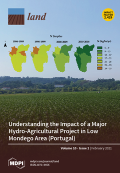
This work was developed to understand the various impacts of the interventions implemented to improve agricultural conditions over recent decades in the Low Mondego region (in Central Portugal). The nitrogen mass balances considered different land use types, inputs and outputs, thereby making it possible to see how human interventions have impacted the variation of the surplus. The major nitrogen sources related to the agricultural sector and an increase in crop productivity are noticeable. However, the implementation of best management practices, the regulations to reduce nitrogen emissions to the atmosphere, and the very particular socioeconomic context in which the interventions occurred have led to a reduction in anthropogenic nitrogen sources, which has been accompanied by a decline in the nitrogen that is exported at the river outlet. View this paper
  • Issues are regarded as officially published after their release is announced to the table of contents alert mailing list.
  • You may sign up for e-mail alerts to receive table of contents of newly released issues.
  • PDF is the official format for papers published in both, html and pdf forms. To view the papers in pdf format, click on the "PDF Full-text" link, and use the free Adobe Reader to open them.
Order results
Result details
Section
Select all
Export citation of selected articles as:
15 pages, 4581 KiB  
Review
Analyzing Regional Geographic Challenges: The Resilience of Chinese Vineyards to Land Degradation Using a Societal and Biophysical Approach
by Yang Yu and Jesús Rodrigo-Comino
Land 2021, 10(2), 227; https://doi.org/10.3390/land10020227 - 23 Feb 2021
Cited by 6 | Viewed by 2884
Abstract
Land degradation, especially soil erosion, is a societal issue that affects vineyards worldwide, but there are no current investigations that inform specifically about soil erosion rates in Chinese vineyards. In this review, we analyze this problem and the need to avoid irreversible damage [...] Read more.
Land degradation, especially soil erosion, is a societal issue that affects vineyards worldwide, but there are no current investigations that inform specifically about soil erosion rates in Chinese vineyards. In this review, we analyze this problem and the need to avoid irreversible damage to soil and their use from a regional point of view. Information about soil erosion in vineyards has often failed to reach farmers, and we can affirm that to this time, soil erosion in Chinese vineyards has been more of a scientific hypothesis than an agronomic or environmental concern. Two hypotheses can be presented to justify this review: (i) there are no official and scientific investigations on vineyard soil erosion in China as the main topic, and it may be understood that stakeholders do not care about this or (ii) there is a significant lack of information and motivation among farmers, policymakers and wineries concerning the consequences of soil erosion. Therefore, this review proposes a plan to study vineyard soil erosion processes for the first time in China and develop a structured scientific proposal considering different techniques and strategies. To achieve these goals, we present a plan considering previous research on other viticultural regions. We hypothesize that the results of a project from a regional geographic point of view would provide the necessary scientific support to facilitate deriving guidelines for sustainable vineyard development in China. We concluded that after completing this review, we cannot affirm why vine plantations have not received the same attention as other crops or land uses. Full article
Show Figures

Figure 1

24 pages, 1295 KiB  
Article
Emerging from Below? Understanding the Livelihood Trajectories of Smallholder Livestock Farmers in Eastern Cape Province, South Africa
by Lovemore C. Gwiriri, James Bennett, Cletos Mapiye and Sara Burbi
Land 2021, 10(2), 226; https://doi.org/10.3390/land10020226 - 23 Feb 2021
Cited by 5 | Viewed by 3067
Abstract
In the context of current agrarian reform efforts in South Africa, this paper analyses the livelihood trajectories of ‘emergent’ farmers in Eastern Cape Province. We apply a rural livelihoods framework to 60 emergent cattle farmers to understand the different capitals they have drawn [...] Read more.
In the context of current agrarian reform efforts in South Africa, this paper analyses the livelihood trajectories of ‘emergent’ farmers in Eastern Cape Province. We apply a rural livelihoods framework to 60 emergent cattle farmers to understand the different capitals they have drawn upon in transitioning to their current class positions and associated vulnerability. The analysis shows that, for the majority of farmers, no real ‘transition’ from subsistence farming has occurred. However, they draw limited resilience from increased livestock holdings, continued reliance on social grants and connections with communal villages. A transition into small-scale commercial farming is apparent for a small number of farmers through the deployment of financial, human and social capitals. However, in following these trajectories, most of these farmers have been made more vulnerable to shocks and stresses than previously. We suggest that key to mitigating this vulnerability will be access to low-risk financial capital, more targeted support, and strategies to support farmers that might not transition from subsistence production. Full article
(This article belongs to the Section Land Socio-Economic and Political Issues)
Show Figures

Figure 1

16 pages, 3535 KiB  
Article
The Amazon Forest Preservation by Clarifying Property Rights and Potential Conflicts: How Experiments Using Fit-for-Purpose Can Help
by Bastiaan Reydon, Mathilde Molendijk, Nicolas Porras and Gabriel Siqueira
Land 2021, 10(2), 225; https://doi.org/10.3390/land10020225 - 23 Feb 2021
Cited by 2 | Viewed by 3353
Abstract
The burning and the deforestation of the Brazilian Amazon forest, which has been recently highlighted by the international press and occurs mostly on public or undesignated land, calls for an in-depth examination. This has traditionally been the main way to grab land, speculate, [...] Read more.
The burning and the deforestation of the Brazilian Amazon forest, which has been recently highlighted by the international press and occurs mostly on public or undesignated land, calls for an in-depth examination. This has traditionally been the main way to grab land, speculate, and simultaneously prove ownership by its occupation. The absence of mapping, registration, and an effective regulation of land property in Brazil, particularly in the Amazon, plays an important role in its deforestation. Recent estimations, besides others, show that the amount of land in this condition is around 200 million ha, near enough ¼ of the national surface. This article, besides examining the Brazilian deforestation characteristics, provides evidence that clear landholders’ rights diminishes deforestation, and that proposals based on concrete cases of participatory clarification of land rights in forest regions using fit for purpose (FfP) methodology promote forest preservation. The article finishes with an example of a land rights clarifying case from small, medium, large, and traditional population landholders. The case is important to illustrate that it is possible to clarify land rights in a FfP way and how that increases the security of landholders, diminishing the pressure on the land and thus reducing the potential deforestation. Full article
Show Figures

Figure 1

15 pages, 757 KiB  
Review
Fostering Evidence-Informed Decision-Making for Protected Areas through the Alberta Parks Social Science Working Group
by Lars K. Hallstrom and Glen T. Hvenegaard
Land 2021, 10(2), 224; https://doi.org/10.3390/land10020224 - 23 Feb 2021
Cited by 2 | Viewed by 2646
Abstract
Since 2012, the Alberta Parks division in the Province of Alberta, Canada has been engaged in a process of building scientific, research, and evidence-informed capacity and practices across the parks system. Following a series of priority-setting workshops and agreements with the research, Parks [...] Read more.
Since 2012, the Alberta Parks division in the Province of Alberta, Canada has been engaged in a process of building scientific, research, and evidence-informed capacity and practices across the parks system. Following a series of priority-setting workshops and agreements with the research, Parks management, and local communities, Alberta Parks has adopted a working group approach and subsequent framework, to support the research and decision-making goals of parks and protected areas management, and the research communities. This Social Science Framework is an innovative way to support evidence-informed decision-making in the public sphere by explicitly linking data-specific needs (benchmark data in social, natural, and applied sciences) with both established and emerging policy and research priorities. It is also a way to situate those needs within a broader goal of inter-organizational collaboration. This paper presents the background and developmental context to the framework, and its structure and desired functionality. The paper concludes with an assessment of the anticipated benefits and potential liabilities of this direction for linking academic and policy agents and organizations in a more formalized structure for environmental policy. Full article
Show Figures

Figure 1

26 pages, 8825 KiB  
Article
Agricultural Land Suitability Assessment Using Satellite Remote Sensing-Derived Soil-Vegetation Indices
by Rubaiya Binte Mostafiz, Ryozo Noguchi and Tofael Ahamed
Land 2021, 10(2), 223; https://doi.org/10.3390/land10020223 - 23 Feb 2021
Cited by 25 | Viewed by 4614
Abstract
Satellite remote sensing technologies have a high potential in applications for evaluating land conditions and can facilitate optimized planning for agricultural sectors. However, misinformed land selection decisions limit crop yields and increase production-related costs to farmers. Therefore, the purpose of this research was [...] Read more.
Satellite remote sensing technologies have a high potential in applications for evaluating land conditions and can facilitate optimized planning for agricultural sectors. However, misinformed land selection decisions limit crop yields and increase production-related costs to farmers. Therefore, the purpose of this research was to develop a land suitability assessment system using satellite remote sensing-derived soil-vegetation indicators. A multicriteria decision analysis was conducted by integrating weighted linear combinations and fuzzy multicriteria analyses in a GIS platform for suitability assessment using the following eight criteria: elevation, slope, and LST vegetation indices (SAVI, ARVI, SARVI, MSAVI, and OSAVI). The relative priorities of the indicators were identified using a fuzzy expert system. Furthermore, the results of the land suitability assessment were evaluated by ground truthed yield data. In addition, a yield estimation method was developed using indices representing influential factors. The analysis utilizing equal weights showed that 43% of the land (1832 km2) was highly suitable, 41% of the land (1747 km2) was moderately suitable, and 10% of the land (426 km2) was marginally suitable for improved yield productions. Alternatively, expert knowledge was also considered, along with references, when using the fuzzy membership function; as a result, 48% of the land (2045 km2) was identified as being highly suitable; 39% of the land (2045 km2) was identified as being moderately suitable, and 7% of the land (298 km2) was identified as being marginally suitable. Additionally, 6% (256 km2) of the land was described as not suitable by both methods. Moreover, the yield estimation using SAVI (R2 = 77.3%), ARVI (R2 = 68.9%), SARVI (R2 = 71.1%), MSAVI (R2 = 74.5%) and OSAVI (R2 = 81.2%) showed a good predictive ability. Furthermore, the combined model using these five indices reported the highest accuracy (R2 = 0.839); this model was then applied to develop yield prediction maps for the corresponding years (2017–2020). This research suggests that satellite remote sensing methods in GIS platforms are an effective and convenient way for agricultural land-use planners and land policy makers to select suitable cultivable land areas with potential for increased agricultural production. Full article
Show Figures

Figure 1

19 pages, 3444 KiB  
Article
Croatian LADM Profile Extension for State-Owned Agricultural Land Management
by Josip Lisjak, Miodrag Roić, Hrvoje Tomić and Siniša Mastelić Ivić
Land 2021, 10(2), 222; https://doi.org/10.3390/land10020222 - 23 Feb 2021
Cited by 7 | Viewed by 2542
Abstract
The paper presents a conceptual model for the disposition of state agricultural land. The model is made as an extension of the Croatian Land Administration Domain Model (LADM) country profile. The LADM 19152:2012 is an International Organization for Standardization (ISO) standard which provides [...] Read more.
The paper presents a conceptual model for the disposition of state agricultural land. The model is made as an extension of the Croatian Land Administration Domain Model (LADM) country profile. The LADM 19152:2012 is an International Organization for Standardization (ISO) standard which provides a formal language to describe the basic information-related components of land administration. The aim of this research is to assess the possibility of using the LADM extension to efficiently manage state-owned agricultural land. Since more than half of state-owned agricultural land in Croatia is not activated, the priority is to increase usage and activate uncultivated agricultural land by users through disposition process. The disposition process is highly regulated and complex in procedures, and it poses difficulties for organizations in the implementation of disposition, so a model of successful management is necessary. The disposition process and the necessary steps are shown—mainly defined by legal regulations—and divided into two phases: the first phase is the development of the Program of Disposition of State-Owned Agricultural Land where the multi-criteria decision analysis (MCDA) for land potential analysis is crucial; the second phase is the realization of the disposition. In line with the disposition process, a Unified Modeling Language (UML) model for this LADM extension on the conceptual level was developed and is presented herein. Finally, the improvement of the agricultural land management system and the related processes are reviewed. Full article
(This article belongs to the Section Land Systems and Global Change)
Show Figures

Figure 1

18 pages, 3869 KiB  
Article
Landscape and Tourism as Tools for Local Development in Mid-Mountain Rural Areas in the Southeast of Spain (Castilla-La Mancha)
by Francisco Cebrián Abellán and Carmen García Martínez
Land 2021, 10(2), 221; https://doi.org/10.3390/land10020221 - 22 Feb 2021
Cited by 25 | Viewed by 3987
Abstract
The modernization of economic activities in mountain areas is conditioned by the physical characteristics of the territory, the weight of activities related to the primary sector, infrastructure deficits, low population density, as well as the declining and ageing population. The response to this [...] Read more.
The modernization of economic activities in mountain areas is conditioned by the physical characteristics of the territory, the weight of activities related to the primary sector, infrastructure deficits, low population density, as well as the declining and ageing population. The response to this situation has involved implementing a certain degree of functional diversification. One of the aspects that has assisted in the expansion of the tertiary sector is leisure and recreational activities. Rural tourism in European mid-mountain regions has emerged as a key element, supported by local development strategies and changing preferences in demand. In the tourism industry, the resources are the raw material, in which landscape plays a leading role. The aim of this prospective study is to evaluate the landscape as a heritage and a tourism resource, focusing on its capacity to reactivate depressed rural areas of inland Spain (mid-mountain areas in the southeast of the autonomous region of Castilla-La Mancha). The study is based on opinions provided by tourists and uses a directed survey as an analytical tool. The results highlight the key role of landscape, especially natural landscape, in the use of such areas for tourism. This, in turn, underlines the need for a greater focus on organizing how the landscape is utilized. Full article
(This article belongs to the Special Issue Landscape and Tourism, Landscapes of Tourism)
Show Figures

Figure 1

22 pages, 1520 KiB  
Article
Hybrid Approaches for Smart Contracts in Land Administration: Lessons from Three Blockchain Proofs-of-Concept
by Rohan Bennett, Todd Miller, Mark Pickering and Al-Karim Kara
Land 2021, 10(2), 220; https://doi.org/10.3390/land10020220 - 22 Feb 2021
Cited by 21 | Viewed by 6912
Abstract
The emergence of “blockchain” technology as an alternative data management technique has spawned a myriad of conceptual and logical design work across multiple industries and sectors. It is also argued to enable operationalisation of the earlier “smart contract” concept. The domain of land [...] Read more.
The emergence of “blockchain” technology as an alternative data management technique has spawned a myriad of conceptual and logical design work across multiple industries and sectors. It is also argued to enable operationalisation of the earlier “smart contract” concept. The domain of land administration has actively investigated these opportunities, albeit also largely at the conceptual level, and usually with a whole-of-sector or “big bang” industry transformation perspective. Less reporting of applied case applications is evident, particularly those undertaken in collaboration with practicing land sector actors. That said, pilots and test cases continue to act as a basis for understanding the relative merits, drawbacks, and implementation challenges of the smart contract concept in land administration. In this vein, this paper extends upon and further refines the existing discourse on smart contracts within the land sector, by giving an updated, if not more nuanced, view of example applications, opportunities, and barriers. In contrast to the earlier works, a hybrid solution that mixes smart contract use with existing technology infrastructure—enabling preservation of the role of a land registry agency as the ultimate arbiter of valid claims—is proposed. This is hypothesised to minimise disruptions, whilst maximising the benefits. Examination of proof-of-concept work on smart contract and blockchain applications in Sweden, Australia (State of New South Wales), and Canada (Province of British Columbia) is undertaken. Comparative analysis is undertaken using several frameworks including: (i) business requirements adherence, (ii) technology readiness and maturity assessment, and (iii) strategic grid analysis. Results show that the hybrid approach enables adherence to land dealing business requirements and that the proofs-of-concept are a necessary step in the development trajectory. Furthering the uptake will likely depend on again taking a whole-of-sector perspective, and attending to remaining issues around business models, stakeholder acceptance, partnerships and trust building, and legal issues linked to data decentralisation and security. Full article
(This article belongs to the Special Issue Land, Innovation, and Social Good)
Show Figures

Figure 1

19 pages, 2824 KiB  
Article
The Potential to Save Agrestal Plant Species in an Intensively Managed Agricultural Landscape through Organic Farming—A Case Study from Northern Germany
by Eugen Görzen, Tim Diekötter, Maike Meyerink, Helen Kretzschmar and Tobias W. Donath
Land 2021, 10(2), 219; https://doi.org/10.3390/land10020219 - 22 Feb 2021
Cited by 4 | Viewed by 2269
Abstract
Intensive agriculture is among the main drivers of diversity decline worldwide. In Central Europe, pressures related with agriculture include habitat loss due to the consolidation of farming units, pesticide and fertilizer use, and shortened crop rotations. In recent decades, this development has resulted [...] Read more.
Intensive agriculture is among the main drivers of diversity decline worldwide. In Central Europe, pressures related with agriculture include habitat loss due to the consolidation of farming units, pesticide and fertilizer use, and shortened crop rotations. In recent decades, this development has resulted in a severe decline of agrestal plant communities. Organic farming has been suggested as a biodiversity friendly way of farming, as it strongly restricts the use of synthetic pesticides and fertilizers and relies on longer crop rotations. It may thus help in saving agrestal plant communities in the future. In this study, we assessed the long-term effects of three types of arable field management (conventional farming, organic farming, and bio-dynamic farming) on three farms in the federal state of Schleswig-Holstein, Northern Germany. We collected data on above-ground plant communities and seed banks and analyzed them with regards to the impact of the farming system and their position in the field using nonmetric multi-dimensional scaling (NMDS) and linear mixed effects models (LME) combined with ANOVA and Tukey contrast tests. Plants in organically or bio-dynamically managed fields differed in their composition and traits from those occurring in conventionally managed fields, i.e., they showed a preference for higher temperatures and were dominated by insect-pollinated species. While conventional farming had negative effects on vegetation and the seed bank, organic and bio-dynamic farms had neutral or slightly positive effects on both. This highlights the potential of the latter two to conserve species even in an intensively managed landscape. In addition, this may halt or even reverse the decrease in arthropod, bird, and mammal species, since agrestal plants constitute an important component of food-webs in agricultural landscapes. Full article
(This article belongs to the Special Issue Landscape Transformation and Changes in Land Use Intensity)
Show Figures

Figure 1

26 pages, 6006 KiB  
Article
A Preliminary Study on the Impact of Landscape Pattern Changes Due to Urbanization: Case Study of Jakarta, Indonesia
by Dikman Maheng, Assela Pathirana and Chris Zevenbergen
Land 2021, 10(2), 218; https://doi.org/10.3390/land10020218 - 21 Feb 2021
Cited by 16 | Viewed by 4213
Abstract
Urbanization is changing land use–land cover (LULC) transforming green spaces (GS) and bodies of water into built-up areas. LULC change is affecting ecosystem services (ES) in urban areas, such as by decreasing of the water retention capacity, the urban temperature regulation capacity and [...] Read more.
Urbanization is changing land use–land cover (LULC) transforming green spaces (GS) and bodies of water into built-up areas. LULC change is affecting ecosystem services (ES) in urban areas, such as by decreasing of the water retention capacity, the urban temperature regulation capacity and the carbon sequestration. The relation between LULC change and ES is still poorly examined and quantified using actual field data. In most ES studies, GS is perceived as lumped areas instead of distributed areas, implicitly ignoring landscape patterns (LP), such as connectivity and aggregation. This preliminary study is one of the first to provide quantitative evidence of the influence of landscape pattern changes on a selection of urban ecosystem services in a megacity as Jakarta, Indonesia. The impact of urbanization on the spatiotemporal changes of ES has been identified by considering connectivity and aggregation of GS. It reveals that LP changes have significantly decreased carbon sequestration, temperature regulation, and runoff regulation by 10.4, 12.4, and 11.5%, respectively. This indicates that the impact of GS on ES is not only determined by its area, but also by its LP. Further detailed studies will be needed to validate these results. Full article
(This article belongs to the Special Issue Dynamics of Urbanization and Ecosystem Services Provision)
Show Figures

Figure 1

19 pages, 3847 KiB  
Article
A Regional GIS-Assisted Multi-Criteria Evaluation of Site-Suitability for the Development of Solar Farms
by Jesús A. Prieto-Amparán, Alfredo Pinedo-Alvarez, Carlos R. Morales-Nieto, María C. Valles-Aragón, Alan Álvarez-Holguín and Federico Villarreal-Guerrero
Land 2021, 10(2), 217; https://doi.org/10.3390/land10020217 - 21 Feb 2021
Cited by 28 | Viewed by 4539
Abstract
One of the fastest-growing renewable energy sources is solar energy. A strategic step for a well-performing solar project is site identification. The evaluation of site-suitability is a complex task, where multiple qualitative and quantitative criteria, inherent to the territory, are involved. In this [...] Read more.
One of the fastest-growing renewable energy sources is solar energy. A strategic step for a well-performing solar project is site identification. The evaluation of site-suitability is a complex task, where multiple qualitative and quantitative criteria, inherent to the territory, are involved. In this study, a GIS-based multi-criteria decision-making (MCDM) methodology for site-suitability evaluation in the development of solar farms (DSF) is presented. Two scenarios, the ranking method (RM) and the Analytical Hierarchy Process (AHP), each representing a different weighting approach, were tested. A case study was performed for the Desert of Chihuahua, Mexico, a region with the potential to provide a significant portion of the country’s energy demand. The RM was more stringent and identified less area with high suitability (1237 km2) compared to the AHP (4983 km2). Given its flexibility in assigning weights, the AHP is considered to have greater potential in identifying site-suitability levels. The final suitability maps of the AHP showed the northern part of the study region to have high suitability for the DSF. Thus, sites in this area could be used for the construction of solar energy projects in the future. This methodology provides a useful tool for land-use planning based on its suitability level. Full article
Show Figures

Figure 1

24 pages, 13520 KiB  
Article
Framing the Hierarchy of Cultural Tourism Attractiveness of Chinese Historic Districts under the Premise of Landscape Conservation
by Haifeng Luo and Bor-Shuenn Chiou
Land 2021, 10(2), 216; https://doi.org/10.3390/land10020216 - 21 Feb 2021
Cited by 8 | Viewed by 3513
Abstract
While empowering the revitalization of Chinese historic districts, the rapid development of the tourism industry may also endanger local cultures and streetscapes. To achieve the goal of sustainable development and find an approach for the Chinese historic districts to develop tourism while taking [...] Read more.
While empowering the revitalization of Chinese historic districts, the rapid development of the tourism industry may also endanger local cultures and streetscapes. To achieve the goal of sustainable development and find an approach for the Chinese historic districts to develop tourism while taking into account landscape conservation, district management, and living convenience, this paper uses expert interviews (including in-depth and Modified Delphi interviews) and structural observation to explore redefining Chinese historic districts and cultural tourism attractiveness in order to provide a hierarchical framework. The research results reveal: 1. The respective redefinitions of a Chinese historic district and cultural tourism attractiveness; 2. A hierarchical framework for the cultural tourism attractiveness of Chinese historic districts, using two aspects—the physical environment and the cultural and natural environments—and five criteria including the morphology of the landscape and tourism infrastructure, along with 21 elements, including the natural and cultural landscapes. This research is expected to provide a theoretical reference for the planning and management of tourism and landscapes in Chinese historic districts. Full article
(This article belongs to the Special Issue Landscape and Tourism, Landscapes of Tourism)
Show Figures

Figure 1

11 pages, 1972 KiB  
Article
Mid-Infrared Spectroscopy Supports Identification of the Origin of Organic Matter in Soils
by Michał Dudek, Cezary Kabała, Beata Łabaz, Paweł Mituła, Magdalena Bednik and Agnieszka Medyńska-Juraszek
Land 2021, 10(2), 215; https://doi.org/10.3390/land10020215 - 21 Feb 2021
Cited by 11 | Viewed by 2745
Abstract
Spectroscopic methods combined with statistics have recently gathered substantial interest in pedological studies. Near-infrared (NIR) spectroscopy has been utilized, for example, for reconstructions of the history and transformations of Chernozems, although no similar research was conducted based on mid-infrared (MIR). In this paper, [...] Read more.
Spectroscopic methods combined with statistics have recently gathered substantial interest in pedological studies. Near-infrared (NIR) spectroscopy has been utilized, for example, for reconstructions of the history and transformations of Chernozems, although no similar research was conducted based on mid-infrared (MIR). In this paper, the relevance of MIR spectroscopy was tested in studies on the origin/affinity of organic matter from chernozemic soils. Samples collected from three vegetation classes (grasslands, forests and arable lands) were investigated using MIR spectroscopy in order to create a statistical model, which was applied on buried profiles of unknown origin. The results showed a clear disjunction of vegetation classes. Samples of buried soil were placed in the space between all classes, indicating the relation to variable vegetation. Therefore, arable lands should not be omitted in paleoecological reconstructions, because we cannot exclude the cultivation of fertile soils before their burial. It was concluded that MIR methods may have similar applicability to NIR spectroscopy. Additionally, MIR spectra may also be discriminated according to the recognized soil type, which allows for direct reconstructions of the transformation trends in buried profiles. Full article
(This article belongs to the Special Issue Application of Spectroscopy and Other Instrumental Methods for Soil)
Show Figures

Figure 1

19 pages, 3770 KiB  
Article
Beyond Supporting Access to Land in Socio-Technical Transitions. How Polish Grassroots Initiatives Help Farmers and New Entrants in Transitioning to Sustainable Models of Agriculture
by Robert Skrzypczyński, Sylwia Dołzbłasz, Krzysztof Janc and Andrzej Raczyk
Land 2021, 10(2), 214; https://doi.org/10.3390/land10020214 - 21 Feb 2021
Cited by 9 | Viewed by 3169
Abstract
The importance of agri-food systems for global sustainability calls for researching and advancing socio-technical transitions towards environmentally friendly models of farming. These transitions hinge on many prerequisites, one of which is providing access to land for farmers and new entrants who experiment with [...] Read more.
The importance of agri-food systems for global sustainability calls for researching and advancing socio-technical transitions towards environmentally friendly models of farming. These transitions hinge on many prerequisites, one of which is providing access to land for farmers and new entrants who experiment with sustainable farming models. However, for socio-technical transitions in farming to be viable, access to land should be complemented with securing access to “intangible” resources such as skills, knowledge or networks. It seems that increasingly often these resources are being provided by various grassroots initiatives. The goal of this paper is to identify how the strategies employed by grassroots initiatives support farmers and new entrants in transitioning to sustainable farming models. In order to answer that question, we perform case studies of three Polish initiatives—Agro-Perma-Lab, PermaKultura.Edu.PL and the Ecological Folk High School in Grzybów—active in promoting agroecology, permaculture and organic farming. The results show a diversity of strategies employed by these initiatives that reflect the frameworks in which they operate. Considering these strategies from the perspective of transition studies suggests that they can be replicated in other contexts and potentially contribute to advancing socio-technical transitions of agri-food systems. Full article
(This article belongs to the Section Land Socio-Economic and Political Issues)
Show Figures

Figure 1

16 pages, 1262 KiB  
Article
Transfer Patterns and Drivers of Embodied Agricultural Land within China: Based on Multi-Regional Decomposition Analysis
by Mengyao Han and Shuchang Li
Land 2021, 10(2), 213; https://doi.org/10.3390/land10020213 - 20 Feb 2021
Cited by 11 | Viewed by 1866
Abstract
Agricultural land is fundamental to human survival and economic development. Unlike other resources, land resources are embodied in trade goods and commodities, which are continuously re-allocated between countries and regions. As a typical ecological element, agricultural land embodied in trade activities can play [...] Read more.
Agricultural land is fundamental to human survival and economic development. Unlike other resources, land resources are embodied in trade goods and commodities, which are continuously re-allocated between countries and regions. As a typical ecological element, agricultural land embodied in trade activities can play an essential role in allocating land resources and advancing agricultural development. Based on the multi-regional decomposition analysis, this study investigated the embodied agricultural land flows among 31 provinces/municipalities of China, and classified the transfer patterns into different drivers including intensity-, trade-, and specialization-driven types. The results showed that the total amount of embodied agricultural land is approximately half of the direct agricultural land use area. Among these regions, Heilongjiang had the largest embodied agricultural land outflows, while Guangdong showed a deficit of agricultural land with embodied inflows. For regions such as Heilongjiang, the relatively high intensity and trade specialization significantly contributed to the embodied agricultural land outflows. For municipalities such as Beijing and Shanghai in China, the embodied agricultural land played a practical role in balancing increasingly scarce land resources. From the embodied perspective, agricultural land linkages between supply and demand in different regions could provide a new perspective to address the agricultural land shortage and avoid the inefficient transfer flows, contributing to the optimal allocation of agricultural land within China. Full article
Show Figures

Figure 1

17 pages, 6553 KiB  
Article
Optimal Irrigation Regime for Woody Species Potentially Suitable for Effective and Sustainable Afforestation in the Desert Region of Mongolia
by Ser-Oddamba Byambadorj, Byung Bae Park, Jonathan O. Hernandez, Narantugs Dulamsuren, Zoljargal Sainbuyan, Oyuntugs Altantugs, Khulan Sharavdorj, In Kyeong Seong and Nyam-Osor Batkhuu
Land 2021, 10(2), 212; https://doi.org/10.3390/land10020212 - 20 Feb 2021
Cited by 7 | Viewed by 2988
Abstract
Long-term studies on plant response mechanisms to different irrigation regimes will provide a better understanding of the survivability and establishment of plant communities in a desert environment. Thus, across 10 years, we regularly investigated the effects of the rainfall (control), rainfall + 4 [...] Read more.
Long-term studies on plant response mechanisms to different irrigation regimes will provide a better understanding of the survivability and establishment of plant communities in a desert environment. Thus, across 10 years, we regularly investigated the effects of the rainfall (control), rainfall + 4 L h−1, rainfall + 8 L h−1, and rainfall + 12 L h−1 irrigation regimes on the growth and leaf morpho-physiology of Tamarix ramosissima Ledeb., Ulmus pumila L., Elaeagnus moorcroftii Wall. ex Schltdl., and Hippophae rhamnoides L. to suggest an optimal irrigation regime for each woody species for effective and sustainable afforestation in Mongolia. We measured the root collar diameter (RCD), annual height growth, survivability, leaf area (LA), specific leaf area (SLA), leaf biomass (LB), total chlorophyll concentration, and predawn (ψp) and midday (ψm) leaf water potentials across the treatments and species. Results showed that trees grown at 12 L h−1 grew taller per year and generally resulted in a higher SLA, but generally resulted in a lower survival rate compared with those in the other treatments in all species. Total chlorophyll content was higher in trees grown under 4 and/or 8 L h−1, particularly for T. ramosissima and E. moorcroftii. Lastly, leaf water potentials were found more negative for trees subjected to 4 L h−1, especially in T. ramosissima and U. pumila, but still resulted in a higher survival rate and LB compared with 12 L h−1. H. rhamnoides showed higher survivability at 8 and/or 12 L h−1 than at 4 L h−1. Therefore, we suggest 4 L h−1 to be the optimal irrigation regime for irrigating T. ramosissima, U. pumila and E. moorcroftii, and 8 and/or 12 L h−1 for H. rhamnoides. Our findings are relevant to ensuring the sustainability of afforestation programs in arid and semiarid landscapes in Mongolia. Full article
(This article belongs to the Special Issue Forest Landscape Restoration: Strategies, Challenges, and Impacts)
Show Figures

Figure 1

18 pages, 1461 KiB  
Article
The Production of Pastoral Space: Modeling Spatial Occupation of Grazing Land for Environmental Impact Assessment Using Structural Equation Modeling
by Bayarmaa Byambaa and Walter T. de Vries
Land 2021, 10(2), 211; https://doi.org/10.3390/land10020211 - 20 Feb 2021
Cited by 1 | Viewed by 2806
Abstract
Environmental impact assessment (EIA) is a key tool for both environmental and land management. It identifies potential adverse and unintended consequences of the projects on land use and the environment and derives possible mitigation measures to address these impacts. Calculating the volume and [...] Read more.
Environmental impact assessment (EIA) is a key tool for both environmental and land management. It identifies potential adverse and unintended consequences of the projects on land use and the environment and derives possible mitigation measures to address these impacts. Calculating the volume and severity of impacts is complex and often relies on selections and simplifications. Moreover, calculating impacts associated with nomadic-pastoral (dynamic) land use is still an unresolved methodological problem. A full understanding of the patterns of dynamic land use in nomadic pastoralism is still lacking. Consequently, EIAs are currently able to predict the negative impacts associated with dynamic land use insufficiently. This article addresses this lacuna by modeling the spatial occupation of grazing land using a statistical modeling technique of structural equation modeling (SEM) and the R package lavaan for SEM, in order to explain the behavior of dynamic land use for EIA. Based on the concepts of the production of space and pastoral spatiality, we specified and tested a model of spatial occupation of grazing areas hypothesizing interrelationships between factors influencing the pastoral space using empirical data from two different ecological zones in Mongolia. The findings suggest that grazing areas, herd mobility, and herd size and composition have direct positive effects on each other. Compared to broad-scale pastoral movements, the herd size and composition significantly affect the size of grazing areas and the extent of fine-scale herding mobility. Herders occupy more pastoral space and increase their daily herding movements at their campsites when the population of livestock increases. By contrast, the herd size and composition do not considerably affect the herders’ decision to migrate for extensive grazing between their seasonal campsites. Likewise, the scale of grazing areas and fine-scale pastoral mobility do not affect significantly the broad-scale herding mobility between campsites. The broad-scale herding mobility is relatively independent of the fine-scale mobility; however, they covary. This is the first study to analyze and quantify the effects of grazing areas, herding mobility, and herd size and composition in the same study. EIA impact prediction should consider grazing areas as a dynamic space that is influenced by grazing orbits, fine and broad-scale herding movements including otor, livestock species, the number of animals as well as households at campsites. Full article
Show Figures

Figure 1

21 pages, 8649 KiB  
Article
Key Disaster-Causing Factors Chains on Urban Flood Risk Based on Bayesian Network
by Shanqing Huang, Huimin Wang, Yejun Xu, Jingwen She and Jing Huang
Land 2021, 10(2), 210; https://doi.org/10.3390/land10020210 - 19 Feb 2021
Cited by 20 | Viewed by 3274
Abstract
Drivers of urban flood disaster risk may be related to many factors from nature and society. However, it is unclear how these factors affect each other and how they ultimately affect the risk. From the perspective of risk uncertainty, flood inundation risk is [...] Read more.
Drivers of urban flood disaster risk may be related to many factors from nature and society. However, it is unclear how these factors affect each other and how they ultimately affect the risk. From the perspective of risk uncertainty, flood inundation risk is considered to be the probability of inundation consequences under the influence of various factors. In this paper, urban flood inundation risk assessment model is established based on Bayesian network, and then key disaster-causing factors chains are explored through influence strength analysis. Jingdezhen City is selected as study area, where the flood inundation probability is calculated, and the paths of these influential factors are found. The results show that the probability of inundation in most areas is low. Risk greater than 0.8 account for about 9%, and most of these areas are located in the middle and southern section of the city. The influencing factors interact with each other in the form of factor chain and, finally, affect the flood inundation. Rainfall directly affects inundation, while river is the key factor on inundation which is influenced by elevation and slope. In addition, in the chain of socio-economic factors, the population will determine the pipe density through affecting gross domestic product (GDP), and lead to the inundation. The approach proposed in this study can be used to find key disaster-causing factors chains, which not only quantitatively reveal the formation of risks but also provide reference for early warning. Full article
(This article belongs to the Section Urban Contexts and Urban-Rural Interactions)
Show Figures

Figure 1

20 pages, 3150 KiB  
Article
Will Rural Collective-Owned Commercial Construction Land Marketization Impact Local Governments’ Interest Distribution? Evidence from Mainland China
by Mingyu Zhang, Qiuxiao Chen, Kewei Zhang and Dongye Yang
Land 2021, 10(2), 209; https://doi.org/10.3390/land10020209 - 19 Feb 2021
Cited by 12 | Viewed by 5379
Abstract
To promote the harmonious human-land relationships and increased urban-rural interaction, rural collective-owned commercial construction land (RCOCCL) marketization reform in some pilot areas was a new attempt by the Chinese Central Government in 2015. In this areas, a novel interest distribution system was established [...] Read more.
To promote the harmonious human-land relationships and increased urban-rural interaction, rural collective-owned commercial construction land (RCOCCL) marketization reform in some pilot areas was a new attempt by the Chinese Central Government in 2015. In this areas, a novel interest distribution system was established with the land right adjustment and the corresponding local governments were likely to benefit through taxation and land appreciation adjustment fund. This study proposed the hypothesis that the RCOCCL marketization reform would improve local government revenue, and explored the actual effect based on panel census data of county-level administrative units from 2010 to 2018. We applied the difference-in-difference (DID) method to analyze the causal effect of this reform on fiscal revenue with 29 pilot areas selected as the treatment group and 1602 county-level units as the control group. The empirical results of the optimized DID robustness test models and the Heckman two-step method showed that the RCOCCL marketization reform does not have a significant impact because of lower land circulation efficiency, the transfer of land transaction costs, and the policy implementation deviations. Thus, weakening the administrative intervention of local governments in the RCOCCL marketization is essential to the land market development in China. Full article
Show Figures

Figure 1

18 pages, 5591 KiB  
Article
Integrating MODIS and Landsat Data for Land Cover Classification by Multilevel Decision Rule
by Xudong Guan, Chong Huang and Rui Zhang
Land 2021, 10(2), 208; https://doi.org/10.3390/land10020208 - 19 Feb 2021
Cited by 5 | Viewed by 2025
Abstract
In some cloudy and rainy regions, the cloud cover is high in moderate-high resolution remote sensing images collected by satellites with a low revisit cycle, such as Landsat. This presents an obstacle for classifying land cover in cloud-covered parts of the image. A [...] Read more.
In some cloudy and rainy regions, the cloud cover is high in moderate-high resolution remote sensing images collected by satellites with a low revisit cycle, such as Landsat. This presents an obstacle for classifying land cover in cloud-covered parts of the image. A decision fusion scheme is proposed for improving land cover classification accuracy by integrating the complementary information of MODIS (Moderate-resolution Imaging Spectroradiometer) time series data with Landsat moderate-high spatial resolution data. The multilevel decision fusion method includes two processes. First, MODIS and Landsat data are pre-classified by fuzzy classifiers. Second, the pre-classified results are assembled according to their assessed performance. Thus, better pre-classified results are retained and worse pre-classified results are restrained. For the purpose of solving the resolution difference between MODIS and Landsat data, the proposed fusion scheme employs an object-oriented weight assignment method. A decision rule based on a compromise operator is applied to assemble pre-classified results. Three levels of data containing different types of information are combined, namely the MODIS pixel-level and object-level data, and the Landsat pixel-level data. The multilevel decision fusion scheme was tested on a site in northeast Thailand. The fusion results were compared with the single data source classification results, showing that the multilevel decision fusion results had a higher overall accuracy. The overall accuracy is improved by more than 5 percent. The method was also compared to the two-level combination results and a weighted sum decision rule-based approach. A comparison experiment showed that the multilevel decision fusion rule had a higher overall accuracy than the weighted sum decision rule-based approach and the low-level combination approach. A major limitation of the method is that the accuracy of some of the land covers, where areas are small, are not as improved as the overall accuracy. Full article
Show Figures

Figure 1

17 pages, 1917 KiB  
Article
Factors on Spatial Heterogeneity of the Grain Production Capacity in the Major Grain Sales Area in Southeast China: Evidence from 530 Counties in Guangdong Province
by Wei Fang, Heliang Huang, Boxi Yang and Qiang Hu
Land 2021, 10(2), 206; https://doi.org/10.3390/land10020206 - 19 Feb 2021
Cited by 4 | Viewed by 2423
Abstract
Grain security is an essential issue for countries across the world. China has witnessed over the last decades not only a rapid growth in the volume of the grain production, but also a divergence in its geographical distributions. Existing studies on the influencing [...] Read more.
Grain security is an essential issue for countries across the world. China has witnessed over the last decades not only a rapid growth in the volume of the grain production, but also a divergence in its geographical distributions. Existing studies on the influencing factors of grain production have overlooked thus spatial heterogeneity. This paper investigates the factors that cause the geographical heterogeneity in grain output levels in Guangdong province of China, in terms of land, labor and capital. To address the spatial attenuation effect of the influencing factors, we use the Geographically Weighted Regression (GWR) on samples of different spatial ranges, which include a total of 530 southern counties from 2015 to 2017. The results show that (a) the effect of land endowment on grain output vary across the east and the west, and between coastal and inland areas; (b) the effect of labor endowment on grain output are inconsistent in the sign and magnitude of the estimates across counties; (c) the effect of agricultural capital on grain production shows heterogeneity spatially (across the east and the west) and economically (across developed and less developed regions). We then analyze the potential mechanism behind this spatial heterogeneity, as well as its policy implications. Full article
Show Figures

Figure 1

16 pages, 12426 KiB  
Article
The Integration of New-Type Urbanization and Rural Revitalization Strategies in China: Origin, Reality and Future Trends
by Mingxing Chen, Yuan Zhou, Xinrong Huang and Chao Ye
Land 2021, 10(2), 207; https://doi.org/10.3390/land10020207 - 18 Feb 2021
Cited by 82 | Viewed by 11232
Abstract
New-type urbanization and rural revitalization have gradually become national strategies, and are an objective requirement for China to be able to enter into a new era of socialism with Chinese characteristics and also an inevitable result of the integration of new-type urbanization and [...] Read more.
New-type urbanization and rural revitalization have gradually become national strategies, and are an objective requirement for China to be able to enter into a new era of socialism with Chinese characteristics and also an inevitable result of the integration of new-type urbanization and rural development in the new stage. This paper reviews the classic theories and cognition of the research on urban–rural relations at home and abroad, and outlines the stage evolution characteristics of urban–rural relations in China. It is believed that urban-biased urbanization has widened the development gap between urban and rural areas since reform and opening up. Under the guidance of the two strategies of new-type urbanization and rural revitalization, urban and rural areas have transitioned from “one-way flow” to “bilateral interaction”, and from “urban bias” to “urban–rural integration”. This paper puts forward a research framework and scientific issues regarding the integration of new-type urbanization and rural revitalization from multidisciplinary perspectives. The integration of these two major strategies will contribute to a new situation of the coordinated and high-quality development of urban and rural areas in the new era. Full article
(This article belongs to the Special Issue Land Perspectives: People, Tenure, Planning, Tools, Space, and Health)
Show Figures

Figure 1

18 pages, 3146 KiB  
Article
Regional Farmers’ Perception and Societal Issues in Vineyards Affected by High Erosion Rates
by Artemi Cerdà and Jesús Rodrigo-Comino
Land 2021, 10(2), 205; https://doi.org/10.3390/land10020205 - 18 Feb 2021
Cited by 21 | Viewed by 2944
Abstract
We explore the current situation in a viticultural region in Eastern Spain from a holistic and multifaceted research approach, which allowed us to understand the biophysical conditions, economic cost, social impact, and perception of the farmers’ community to the use of catch crops. [...] Read more.
We explore the current situation in a viticultural region in Eastern Spain from a holistic and multifaceted research approach, which allowed us to understand the biophysical conditions, economic cost, social impact, and perception of the farmers’ community to the use of catch crops. A survey of the perception of the farmers, and an assessment of the biophysical impact of catch crops (CC) and tillage (C = Control plot) on soil organic matter, bulk density, infiltration capacity (single ring infiltrometer), and runoff generation and soil erosion (rainfall simulation experiments) was carried out. Two representative fields as study sites were selected in Les Alcusses valley, within Els Alforins wine production region. The results show that the use of CC increased soil organic matter, favored higher infiltration rates and runoff generation was delayed. Moreover, runoff rates and soil erosion were lowered. The perception of the farmers was mainly against the use of catch crops due to their view as it being ‘dirty’, their cost, and the loss of their reputation and respect by other farmers. Our survey proves that the farmers would accept the catch crops if a subsidy of 76.56 € ha−1 on average would be paid. Farmers see the use of a catch crop more as a benefit for the health of the Planet than for themselves. To achieve land degradation neutrality, education and dissemination programs should be developed to teach and inform the farmers of their key role in the proper management of vineyards. Full article
(This article belongs to the Special Issue Land Degradation Neutrality (LDN))
Show Figures

Figure 1

15 pages, 1574 KiB  
Article
Mediterranean Landscape Re-Greening at the Expense of South American Agricultural Expansion
by Jaime Martínez-Valderrama, María E. Sanjuán, Gabriel del Barrio, Emilio Guirado, Alberto Ruiz and Fernando T. Maestre
Land 2021, 10(2), 204; https://doi.org/10.3390/land10020204 - 17 Feb 2021
Cited by 14 | Viewed by 5513
Abstract
The stabling of livestock farming implies changes in both local ecosystems (regeneration of forest stands via reduced grazing) and those located thousands of kilometers away (deforestation to produce grain for feeding livestock). Despite their importance, these externalities are poorly known. Here we evaluated [...] Read more.
The stabling of livestock farming implies changes in both local ecosystems (regeneration of forest stands via reduced grazing) and those located thousands of kilometers away (deforestation to produce grain for feeding livestock). Despite their importance, these externalities are poorly known. Here we evaluated how the intensification and confinement of livestock in Spain has affected forest surface changes there and in South America, the largest provider of soybeans for animal feed to the European Union. For this purpose, we have used Spanish soybean import data from Brazil, Paraguay and Argentina and a land condition map of Spain. The area of secondary forest in Spain that has regenerated as a result of livestock stabling has been ~7000 kha for the decade 2000–2010. In the same period, 1220 kha of high value South American ecosystems (e.g., Chaco dry Forest, Amazonian rainforest or Cerrado) have been deforested. While these figures may offer a favorable interpretation of the current industrial livestock production, it is not possible to speak of compensation when comparing the destruction of well-structured ecosystems, such as primary South American forests, with the creation of secondary forest landscapes in Spain, which are also prone to wildfires. Our results highlight how evaluating land use change policies at a national or regional level is an incomplete exercise in our highly telecoupled and globalized world. Full article
Show Figures

Figure 1

15 pages, 12144 KiB  
Article
Vegetation Degradation of Guanshan Grassland Suppresses the Microbial Biomass and Activity of Soil
by Yanmei Liu, Hangyu Yang, Zisheng Xing, Yali Zou and Zheming Cui
Land 2021, 10(2), 203; https://doi.org/10.3390/land10020203 - 17 Feb 2021
Cited by 4 | Viewed by 1829
Abstract
Changes in vegetation influence the function of grassland ecosystems. A degradation of the vegetation type has been found from high to low altitudes in Guanshan grassland in the order of forest grassland (FG) < shrub grassland (SG) < herb grassland (HG). However, there [...] Read more.
Changes in vegetation influence the function of grassland ecosystems. A degradation of the vegetation type has been found from high to low altitudes in Guanshan grassland in the order of forest grassland (FG) < shrub grassland (SG) < herb grassland (HG). However, there is poor information regarding the effect of vegetation degradation on soil microbes in Guanshan grassland. Therefore, our study evaluated the impact of vegetation degradation on the microbial parameters of soil, as well as the mechanisms responsible for these variations. Soils were sampled from 0 to 30 cm under the FG, SG, and HG in Guanshan grassland for determining the microbial biomass, enzymatic activities, basal respiration (BR), and metabolic quotient (qCO2) in April and July 2017. The results showed that vegetation types are important factors that obviously influence the above-mentioned soil microbial properties. The FG and SG had significantly higher soil microbial biomass, enzymatic activities, and BR than those of the HG, but markedly lower qCO2 (p < 0.05). Soil pH, available nitrogen (AN), organic carbon (SOC), total phosphorus (TP), available P (AP), and total N (TN) were key factors in the decline in the soil microbial biomass and microbial activities of the degraded vegetation. Moreover, slope aspects also affected the soil microbial properties, with the east slope having higher soil microbial biomass, enzymatic activities, and BR and lower qCO2 than the west slope. Conclusively, vegetation degradation has led to a decline in the soil microbial biomass and microbial activities, indicating the degradation of the Guanshan grassland ecosystem. Full article
Show Figures

Figure 1

10 pages, 1386 KiB  
Article
Effect of Previous Crop Roots on Soil Compaction in 2 Yr Rotations under a No-Tillage System
by Jay D. Jabro, Brett L. Allen, Tatyana Rand, Sadikshya R. Dangi and Joshua W. Campbell
Land 2021, 10(2), 202; https://doi.org/10.3390/land10020202 - 17 Feb 2021
Cited by 15 | Viewed by 2797
Abstract
Compacted soils affect global crop productivity and environmental quality. A field study was conducted from 2014 to 2020 in the northern Great Plains, USA, to evaluate the effect of various rooting systems on soil compaction in 2 yr rotations of camelina (Camelina [...] Read more.
Compacted soils affect global crop productivity and environmental quality. A field study was conducted from 2014 to 2020 in the northern Great Plains, USA, to evaluate the effect of various rooting systems on soil compaction in 2 yr rotations of camelina (Camelina sativa L.), carinata (Brassica carinata A.) and a cover crop mix planted in place of fallow with durum (Triticum durum D.). The study was designed as a randomized complete block with three replications in a no-tillage system. The soil was classified as Dooley sandy loam (fine-loamy, mixed, superactive, frigid Typic Argiustolls) derived from glacial till parent material. Three measurements of soil penetration resistance (PR) were taken with a penetrometer to a depth of 0–30 cm within each plot. Soil moisture contents were determined using a TDR sensor at the time of PR measurements. Both measurements were monitored prior to planting in spring and after harvest. Initial PR results from spring 2014 showed that all plots had an average of 2.244 MPa between the 8–20 cm depth, due to a history of tillage and wheel traffic caused by various field activities. Covariance analysis indicated that soil PR was not significantly affected by crop type and moisture content. After one cycle of the 2 yr rotation, the 2016 measurements indicated that the compacted layer existed at the same initial depths. However, after two and three cycles, soil PR values were reduced to 1.480, 1.812, 1.775, 1.645 MPa in spring 2018 and 1.568, 1.581, 1.476, 1.458 MPa in 2020 under camelina, carinata, cover crop mix, and durum treatments, respectively. These findings indicate that previous cover crop roots could effectively improve soil compaction by penetrating the compacted layer, decompose over time and form voids and root channels. Although these results are novel and significant, further research is needed on different soils and under cover crops with different root systems to support our findings prior to making any conclusion. Full article
(This article belongs to the Special Issue Soil Tillage Systems and Conservative Agriculture)
Show Figures

Figure 1

19 pages, 7655 KiB  
Review
Restoring the Unrestored: Strategies for Restoring Global Land during the UN Decade on Ecosystem Restoration (UN-DER)
by Purushothaman Chirakkuzhyil Abhilash
Land 2021, 10(2), 201; https://doi.org/10.3390/land10020201 - 17 Feb 2021
Cited by 69 | Viewed by 12984
Abstract
Restoring the health of degraded land is critical for overall human development as land is a vital life-supporting system, directly or indirectly influencing the attainment of the UN Sustainable Development Goals (UN-SDGs). However, more than 33% of the global land is degraded and [...] Read more.
Restoring the health of degraded land is critical for overall human development as land is a vital life-supporting system, directly or indirectly influencing the attainment of the UN Sustainable Development Goals (UN-SDGs). However, more than 33% of the global land is degraded and thereby affecting the livelihood of billions of people worldwide. Realizing this fact, the 73rd session of the UN Assembly has formally adopted a resolution to celebrate 2021–2030 as the UN Decade on Ecosystem Restoration (UN-DER), for preventing, halting, and reversing degradation of ecosystems worldwide. While this move is historic and beneficial for both people and the planet, restoration of degraded land at different scales and levels requires a paradigm shift in existing restoration approaches, fueled by the application of applied science to citizen/community-based science, and tapping of indigenous and local knowledge to advanced technological breakthroughs. In addition, there is a need of strong political will and positive behavioral changes to strengthen restoration initiatives at the grassroot level and involvement of people from all walks of life (i.e., from politicians to peasants and social workers to scientists) are essential for achieving the targets of the UN-DER. Similarly, financing restoration on the ground by the collective contribution of individuals (crowd funding) and institutions (institutional funding) are critical for maintaining the momentum. Private companies can earmark lion-share of their corporate social responsibility fund (CSR fund) exclusively for restoration. The adoption of suitable bioeconomy models is crucial for maintaining the perpetuity of the restoration by exploring co-benefits, and also for ensuring stakeholder involvements during and after the restoration. This review underpins various challenges and plausible solutions to avoid, reduce, and reverse global land degradation as envisioned during the UN-DER, while fulfilling the objectives of other ongoing initiatives like the Bonn Challenge and the UN-SDGs. Full article
(This article belongs to the Special Issue Restoring Degraded Lands to Attain UN-SDGs)
Show Figures

Figure 1

13 pages, 275 KiB  
Article
The Effects of Management (Tillage, Fertilization, Plant Density) on Soybean Yield and Quality in a Three-Year Experiment under Transylvanian Plain Climate Conditions
by Felicia Chețan, Cornel Chețan, Ileana Bogdan, Adrian Ioan Pop, Paula Ioana Moraru and Teodor Rusu
Land 2021, 10(2), 200; https://doi.org/10.3390/land10020200 - 16 Feb 2021
Cited by 19 | Viewed by 2363
Abstract
The regional agroecological conditions, specific to the Transylvanian Plain, are favorable to soybean crops, but microclimate changes related to global warming have imposed the need for agrotechnical adaptive measures in order to maintain the level of soybean yield. In this study, we consider [...] Read more.
The regional agroecological conditions, specific to the Transylvanian Plain, are favorable to soybean crops, but microclimate changes related to global warming have imposed the need for agrotechnical adaptive measures in order to maintain the level of soybean yield. In this study, we consider the effect of two soil tillage systems, the seeding rate, as well as the fertilizer dosage and time of application on the yield and quality of soybean crops. A multifactorial experiment was carried out through the A × B × C × D − R: 3 × 2 × 3 × 3 − 2 formula, where A represents the year (a1, 2017; a2, 2018; and a3, 2019); B represents the soil tillage system (b1, conventional tillage with mouldboard plough; b2, reduced tillage with chisel cultivator); C represents the fertilizer variants (c1, unfertilized; c2, one single rate of fertilization: 40 kg ha−1 of nitrogen + 40 kg ha−1 of phosphorus; and c3, two rates of fertilization: 40 kg ha−1 of nitrogen + 40 kg ha−1 of phosphorus (at sowing) + 46 kg ha−1 of nitrogen at V3 stage); D represents the seeding rate (1 = 45 germinating grains (gg) m−2; d2 = 55 gg m−2; and d3 = 65 gg m−2); and R represents the replicates (r1 = the first and r2 = the second). Tillage had no effect, the climate specific of the years and fertilization affected the yield and the quality parameters. Regarding the soybean yield, it reacted favorably to a higher seeding rate (55–65 gg m−2) and two rates of fertilization. The qualitative characteristics of soybeans are affected by the fertilization rates applied to the crop, which influence the protein and fiber content in the soybean grains. Higher values of protein content were recorded with a reduced tillage system, i.e., 38.90 g kg−1 DM in the variant with one single rate of fertilization at a seeding rate of 45 gg per m−2 and 38.72 g kg−1 DM in the variant with two fertilizations at a seeding rate of 65 gg m−2. Full article
(This article belongs to the Special Issue Soil Tillage Systems and Conservative Agriculture)
18 pages, 441 KiB  
Article
Decentralization as a Strategy to Scale Fit-for-Purpose Land Administration: An Indian Perspective on Institutional Challenges
by Serene Ho, Pranab R. Choudhury, Nivedita Haran and Rebecca Leshinsky
Land 2021, 10(2), 199; https://doi.org/10.3390/land10020199 - 16 Feb 2021
Cited by 10 | Viewed by 4062
Abstract
Many countries grapple with the intractable problem of formalizing tenure security. The concept of ‘fit-for-purpose land administration’ (FFPLA) offers a way forward by advocating a shift towards a more flexible, pragmatic and inclusive approach for land rights recording. Inherently, the process and outcome [...] Read more.
Many countries grapple with the intractable problem of formalizing tenure security. The concept of ‘fit-for-purpose land administration’ (FFPLA) offers a way forward by advocating a shift towards a more flexible, pragmatic and inclusive approach for land rights recording. Inherently, the process and outcome of implementing FFPLA will have significant socio-political ramifications but these have not received much attention in the literature; additionally, few papers have considered this in the context of decentralization, an endorsed strategy for implementing FFPLA. This paper contributes to this gap by critically analyzing three land formalization initiatives in India which have employed flexible recording approaches and where decentralization is used to scale implementation. The cases show how quickly decentralization can kickstart implementation at scale via collaborations with local governing bodies and partnerships with non-state actors. An institutionalist approach highlights ensuing political contests between new and traditional land actors that inhibit political authority, and the challenges of coordinating a network of public and private actors without clear formal collaborative governance structures to ensure democratic outcomes. In doing so, we contribute to governance knowledge around FFPLA implementation so that it is ‘fit-for-people’ and better able to support policies and processes to secure land rights at scale. Full article
Show Figures

Figure 1

23 pages, 1009 KiB  
Article
Community Preparation and Vulnerability Indices for Floods in Pahang State of Malaysia
by Alias Nurul Ashikin, Mohd Idris Nor Diana, Chamhuri Siwar, Md. Mahmudul Alam and Muhamad Yasar
Land 2021, 10(2), 198; https://doi.org/10.3390/land10020198 - 16 Feb 2021
Cited by 15 | Viewed by 4371
Abstract
The east coast of Malaysia is frequently hit by monsoon floods every year that severely impact people, particularly those living close to the river bank, which is considered to be the most vulnerable and high-risk areas. We aim to determine the most vulnerable [...] Read more.
The east coast of Malaysia is frequently hit by monsoon floods every year that severely impact people, particularly those living close to the river bank, which is considered to be the most vulnerable and high-risk areas. We aim to determine the most vulnerable area and understand affected residents of this community who are living in the most sensitive areas caused by flooding events in districts of Temerloh, Pekan, and Kuantan, Pahang. This study involved collecting data for vulnerability index components. A field survey and face-to-face interviews with 602 respondents were conducted 6 months after the floods by using a questionnaire evaluation based on the livelihood vulnerability index (LVI). The findings show that residents in the Temerloh district are at higher risk of flooding damage compared to those living in Pekan and Kuantan. Meanwhile, the contribution factor of LVI-Intergovernmental Panel on Climate Change (IPCC) showed that Kuantan is more exposed to the impact of climate change, followed by Temerloh and Pekan. Among all the principal components shown, food components were considered to be the most vulnerable. Meanwhile, water components were categorised as the most invulnerable. Preventive planning involves preserving human life, minimising damage to household products, preserving crops and animals, adequate supply of clean water and food, good health and ensuring financial sustainability as an indication of changing livelihoods, sustainable food-storing systems, and other protective steps to curb damage and injury caused by annual flood strikes. Information generated on LVI assessment and adaptation procedures will help policymakers reduce people’s vulnerability in the face of floods and ensure proper plans are put in place in all relevant areas. Full article
(This article belongs to the Special Issue Geochemical Mapping in Land Managing)
Show Figures

Figure 1

Previous Issue
Next Issue
Back to TopTop