Next Issue
Volume 10, February
Previous Issue
Volume 9, December


Land, Volume 10, Issue 1 (January 2021) – 90 articles

Cover Story (view full-size image): 
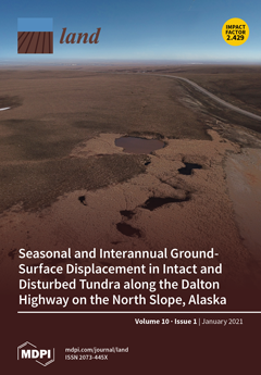
Climate change and land exploitation alter the Arctic tundra landscape through an increase in the thickness of seasonally freezing and thawing layer (active layer) and ground-surface deformation due to ground ice melting (thermokarst). In the cover photo, a thermokarst area with small thaw lakes triggered by road maintenance activities for the Dalton Highway is invading intact tundra. Our repeated field surveys of high-precision GNSS revealed spatiotemporal variations in the seasonal thaw settlement (STS) and thaw depth (TD) in intact and disturbed tundra. Weak or moderate correlation between STS and TD found at the intact sites became obscure as the thermokarst disturbance progressed, leading to higher uncertainty in the prediction of TD from remotely measured STS. View this paper
  • Issues are regarded as officially published after their release is announced to the table of contents alert mailing list.
  • You may sign up for e-mail alerts to receive table of contents of newly released issues.
  • PDF is the official format for papers published in both, html and pdf forms. To view the papers in pdf format, click on the "PDF Full-text" link, and use the free Adobe Reader to open them.
Order results
Result details
Section
Select all
Export citation of selected articles as:
15 pages, 1147 KiB  
Article
Land-Use Planning and the Public: Is There an Optimal Degree of Civic Participation?
by Miroslav Kopáček
Land 2021, 10(1), 90; https://doi.org/10.3390/land10010090 - 19 Jan 2021
Cited by 9 | Viewed by 3283
Abstract
Civic participation has an irreplaceable role in the land-use planning process because it contributes a practical perspective to expert knowledge. This article discusses whether there is actually a level of civic participation that can be considered optimal, which would allow experts to effectively [...] Read more.
Civic participation has an irreplaceable role in the land-use planning process because it contributes a practical perspective to expert knowledge. This article discusses whether there is actually a level of civic participation that can be considered optimal, which would allow experts to effectively obtain information from everyday users of the territory, who have the best practical knowledge of it; experts may also gain sufficient feedback on intended developments, based on knowledge about civic participation from representatives of individual municipalities. The article also proposes measures that can promote an optimal degree of participation in the land-use planning process. The fieldwork was conducted in the form of semi-structured interviews with the mayors of municipalities with a population of up to 2000 inhabitants in selected districts of the Ústí Region (Czech Republic). The results suggest that the optimal degree of civic participation in land-use planning should have a representative extent, so it should not merely be a matter of individuals, but also one of groups of dozens of people, and such groups should encompass a balanced variety of characteristics; an optimal level of civic participation should also provide the maximum number of relevant impulses. Measures that may secure and foster an optimal degree of civic participation in land-use planning include (1) striving to avoid preferring purely voluntary participation; (2) simultaneously utilizing various tools to engage inhabitants; (3) educating inhabitants on a regular basis; and (4) consistently communicating and providing feedback, while also searching for informal means of communication and discussion. Full article
(This article belongs to the Special Issue Rural Space Modeling)
Show Figures

Figure 1

16 pages, 5182 KiB  
Article
Morphogenesis of Emerging Settlements: Mapping Incremental Urbanism
by Hesam Kamalipour and Aminreza Iranmanesh
Land 2021, 10(1), 89; https://doi.org/10.3390/land10010089 - 19 Jan 2021
Cited by 13 | Viewed by 3529
Abstract
Informal urbanism has become a widespread form of urbanisation, particularly in the context of the global South. While there is an emerging body of knowledge focusing on the morphologies of informal settlements, the incremental transformations of emerging settlements have remained underexplored. Drawing on [...] Read more.
Informal urbanism has become a widespread form of urbanisation, particularly in the context of the global South. While there is an emerging body of knowledge focusing on the morphologies of informal settlements, the incremental transformations of emerging settlements have remained underexplored. Drawing on a case study of an emerging settlement in Nigeria, we map the emergence and incremental transformation of access networks and buildings. This is an exploratory study focusing on the morphogenesis of emerging settlements to explore how the incremental production of space works. We adopt urban mapping and typology as key methods. Following the analysis of emerging access networks, this paper identifies three primary types of change, namely add, alter, and remove, and further develops a typology of emerging junctions by specifying four types of T, Y, X, and Mixed shape junctions. The incremental transformations of buildings primarily incorporate practices of addition and removal, among others. We also identify three forms of relation between the emerging access networks and buildings: access network first, building first, and co-production. We argue that moving towards developing adaptive design interventions relies on a sophisticated understanding of the process of morphogenesis in emerging settlements. Full article
Show Figures

Figure 1

5 pages, 2041 KiB  
Editorial
Urban Ecosystem Services: New Findings for Landscape Architects, Urban Planners, and Policymakers
by Alessio Russo and Giuseppe T. Cirella
Land 2021, 10(1), 88; https://doi.org/10.3390/land10010088 - 19 Jan 2021
Cited by 8 | Viewed by 8492
Abstract
More than half of the world’s population lives in urban ecosystems [...] Full article
(This article belongs to the Special Issue Urban Ecosystem Services)
Show Figures

Figure 1

18 pages, 5830 KiB  
Article
Tracking the Role of Policies and Economic Factors in Driving the Forest Change Trajectories within the Guangdong-Hongkong-Macao Region of China: A Remote Sensing Perspective
by Yuyang Xian, Yongquan Lu, Zipporah Musyimi and Guilin Liu
Land 2021, 10(1), 87; https://doi.org/10.3390/land10010087 - 18 Jan 2021
Cited by 5 | Viewed by 3445
Abstract
Though forest ecosystems play a critical role in enhancing ecological, environmental, economic, and societal sustainability, on a global scale, their future outlooks are uncertain given the wide-ranging threats they are exposed to. The uniqueness of this study is to provide a line of [...] Read more.
Though forest ecosystems play a critical role in enhancing ecological, environmental, economic, and societal sustainability, on a global scale, their future outlooks are uncertain given the wide-ranging threats they are exposed to. The uniqueness of this study is to provide a line of evidence in which forest change trajectories are not only tracked but also evaluated through the lenses of forestry and economic oriented events’ timelines. The dynamics of forest change trajectories were mined using a temporal model. To understand the forces driving the changes, the change trajectories were linked to the timelines when forestry policies and economic factors where adopted. During 1980–1990, the forest change trajectory assumed a peak (forest gain). This was interpreted as a response to the adoption of policies that promoted ecological conservation. During 1995–2010, the forest change trajectories reflected the response to the antagonistic effects of forest-oriented policies and the economy-oriented drivers. During 2010–2015, the forest change trajectories assumed a deep (forest loss). This was attributed as a response to the economy-oriented factors. However, inferences from the results indicated that deforestation driven by economic factors was restricted by forest management policies. Though the role of economic factors has promoted developments within the study area, forest policies still constrain illegal logging and play a key role in protecting forests. We hope that insights from this study will inform, support and guide decisions for precise and smart sustainable forest management plans. Full article
Show Figures

Figure 1

19 pages, 6604 KiB  
Article
Research on an Analytical Framework for Urban Spatial Structural and Functional Optimisation: A Case Study of Beijing City, China
by Wenting Zhang and Bo Li
Land 2021, 10(1), 86; https://doi.org/10.3390/land10010086 - 18 Jan 2021
Cited by 14 | Viewed by 2832
Abstract
A number of severe ecological problems, and the altered structure of urban spaces, are ascribed to rapid urbanisation. Hence, an analytical framework for urban spatial structure and functional optimisation is highly beneficial to balance the contradiction between developing urban areas and protecting their [...] Read more.
A number of severe ecological problems, and the altered structure of urban spaces, are ascribed to rapid urbanisation. Hence, an analytical framework for urban spatial structure and functional optimisation is highly beneficial to balance the contradiction between developing urban areas and protecting their ecosystems. In this paper, the proposed analytical framework included three parts. We first delineated the ecological suitability zones (ESZs) of Beijing City by applying the minimum cumulative resistance (MCR) model. Subsequently, considering various socioeconomic and natural environmental factors, the Markov chain model and future land-use simulation (FLUS) model were utilised to predict the urban spatial structure of Beijing in 2031. Finally, taking the ESZ results as a constraint, three scenarios were designed to optimise the extent of city sprawl: the business as usual (BAU) scenario, ecological security (ES) scenario and ecological priority (EP) scenario. We found that the ESZs contained three zones: an ecological control zone (63%), a restricted development zone (22%), and a concentrated development zone (15%). After comparing the three scenarios, we discovered that the ES scenarios ensured the bottom line in terms of Beijing’s ecological security. Additionally, under the EP scenario, the urban spatial structure and function were further optimised. Our study can provide new ideas and technical support for the reasonable layout of urban spatial structure. Full article
(This article belongs to the Section Urban Contexts and Urban-Rural Interactions)
Show Figures

Figure 1

20 pages, 1169 KiB  
Case Report
Urban Green Space Composition and Configuration in Functional Land Use Areas in Addis Ababa, Ethiopia, and Their Relationship with Urban Form
by Eyasu Markos Woldesemayat and Paolo Vincenzo Genovese
Land 2021, 10(1), 85; https://doi.org/10.3390/land10010085 - 18 Jan 2021
Cited by 13 | Viewed by 7880
Abstract
This study aimed to assess the compositions and configurations of the urban green spaces (UGS) in urban functional land use areas in Addis Ababa, Ethiopia. The UGS data were extracted from Landsat 8 (OLI/TIRS) imagery and examined along with ancillary data. The results [...] Read more.
This study aimed to assess the compositions and configurations of the urban green spaces (UGS) in urban functional land use areas in Addis Ababa, Ethiopia. The UGS data were extracted from Landsat 8 (OLI/TIRS) imagery and examined along with ancillary data. The results showed that the high-density mixed residence, medium-density mixed residence, and low-density mixed residence areas contained 16.7%, 8.7%, and 42.6% of the UGS, respectively, and together occupied 67.5% of the total UGS in the study area. Manufacturing and storage, social services, transport, administration, municipal function, and commercial areas contained 11.6%, 8.2%, 6.6%, 3.3%, 1.3%, and 1% of the UGS, respectively, together account for only 32% of the total UGS, indicating that two-third of the UGS were found in residential areas. Further, the results showed that 86.2% of individual UGS measured less than 3000 m2, while 13.8% were greater than 3000 m2, demonstrating a high level of fragmentation. The results also showed that there were strong correlations among landscape metrics, while the relationship between urban form and landscape metrics was moderate. Finally, more studies need to be conducted on the spatial pattern characteristics of UGS using very high-resolution (VHR) images. Additionally, future urban planning, design, and management need to be guided by an understanding of the composition and configuration of the UGS. Full article
Show Figures

Figure 1

15 pages, 3250 KiB  
Article
Dynamics of Changes in Selected Soil Traits in the Profiles of Arable Soils Anthropogenically Alkalised by the Cement and Lime Industry within the Kielecko-Łagowski Vale (Poland)
by Anna Świercz, Agnieszka Gandzel and Ilona Tomczyk-Wydrych
Land 2021, 10(1), 84; https://doi.org/10.3390/land10010084 - 18 Jan 2021
Cited by 3 | Viewed by 1755
Abstract
This study presents the influence of the cement and lime industry on the physical and chemical properties of arable soils. In spite of using modern forms of environmental protection against dust emissions, this type of industry causes unfavourable phenomenon of excessive alkalisation of [...] Read more.
This study presents the influence of the cement and lime industry on the physical and chemical properties of arable soils. In spite of using modern forms of environmental protection against dust emissions, this type of industry causes unfavourable phenomenon of excessive alkalisation of soil. This process is relatively rare in Poland. However, in the Świętokrzyskie Province, it has been responsible for the largest transformation of soils in recent years. The analysis included soil samples taken from five profiles located in the vicinity of Dyckerhoff Polska Sp. z o.o. Nowiny Cement Plant. The study results obtained in 2019 were compared with those obtained in 1978 and 2005. The most attention was paid to soil pH; CaCO3 content; organic carbon and nitrogen content; concentrations of available components such as P2O5, K2O and Mg; and the saturation level of sorption complex with alkaline cations. It was found that long-term imission of pollutants caused significant changes in the basic soil properties, which remain in soils despite the evident decrease in the cement-lime dust emission. These include high pH values, excessive CaCO3 content, high soil saturation with alkaline cations and decreases in total carbon content, which were especially visible in soil humus horizons. Full article
Show Figures

Figure 1

12 pages, 2393 KiB  
Article
Characterization of Soil Carbon Stocks in the City of Johannesburg
by Kelebohile Rose Seboko, Elmarie Kotze, Johan van Tol and George van Zijl
Land 2021, 10(1), 83; https://doi.org/10.3390/land10010083 - 18 Jan 2021
Cited by 4 | Viewed by 2728
Abstract
Soil organic carbon (SOC) is a crucial indicator of soil health and soil productivity. The long-term implications of rapid urbanization on sustainability have, in recent years, raised concern. This study aimed to characterize the SOC stocks in the Johannesburg Granite Dome, a highly [...] Read more.
Soil organic carbon (SOC) is a crucial indicator of soil health and soil productivity. The long-term implications of rapid urbanization on sustainability have, in recent years, raised concern. This study aimed to characterize the SOC stocks in the Johannesburg Granite Dome, a highly urbanized and contaminated area. Six soil hydropedological groups; (recharge (deep), recharge (shallow), responsive (shallow), responsive (saturated), interflow (A/B), and interflow (soil/bedrock)) were identified to determine the vertical distribution of the SOC stocks and assess the variation among the soil groups. The carbon (C) content, bulk density, and soil depth were determined for all soil groups, and thereafter the SOC stocks were calculated. Organic C stocks in the A horizon ranged, on average, from 33.55 ± 21.73 t C ha−1 for recharge (deep) soils to 17.11 ± 7.62 t C ha−1 for responsive (shallow) soils. Higher C contents in some soils did not necessarily indicate higher SOC stocks due to the combined influence of soil depth and bulk density. Additionally, the total SOC stocks ranged from 92.82 ± 39.2 t C ha−1 for recharge (deep) soils to 22.81 ± 16.84 t C ha−1 for responsive (shallow) soils. Future studies should determine the SOC stocks in urban areas, taking diverse land-uses and the presence of iron (Fe) oxides into consideration. This is crucial for understanding urban ecosystem functions. Full article
(This article belongs to the Special Issue Soil Management for Sustainability)
Show Figures

Figure 1

15 pages, 29849 KiB  
Article
Emerging Anthropogenic Influences on the Southcentral Alaska Temperature and Precipitation Extremes and Related Fires in 2019
by Uma S. Bhatt, Rick T. Lader, John E. Walsh, Peter A. Bieniek, Richard Thoman, Matthew Berman, Cecilia Borries-Strigle, Kristi Bulock, Jonathan Chriest, Micah Hahn, Amy S. Hendricks, Randi Jandt, Joseph Little, Daniel McEvoy, Chris Moore, T. Scott Rupp, Jennifer Schmidt, Eric Stevens, Heidi Strader, Christine Waigl, James White, Alison York and Robert Zieladd Show full author list remove Hide full author list
Land 2021, 10(1), 82; https://doi.org/10.3390/land10010082 - 17 Jan 2021
Cited by 11 | Viewed by 7071
Abstract
The late-season extreme fire activity in Southcentral Alaska during 2019 was highly unusual and consequential. Firefighting operations had to be extended by a month in 2019 due to the extreme conditions of hot summer temperature and prolonged drought. The ongoing fires created poor [...] Read more.
The late-season extreme fire activity in Southcentral Alaska during 2019 was highly unusual and consequential. Firefighting operations had to be extended by a month in 2019 due to the extreme conditions of hot summer temperature and prolonged drought. The ongoing fires created poor air quality in the region containing most of Alaska’s population, leading to substantial impacts to public health. Suppression costs totaled over $70 million for Southcentral Alaska. This study’s main goals are to place the 2019 season into historical context, provide an attribution analysis, and assess future changes in wildfire risk in the region. The primary tools are meteorological observations and climate model simulations from the NCAR CESM Large Ensemble (LENS). The 2019 fire season in Southcentral Alaska included the hottest and driest June–August season over the 1979–2019 period. The LENS simulation analysis suggests that the anthropogenic signal of increased fire risk had not yet emerged in 2019 because of the CESM’s internal variability, but that the anthropogenic signal will emerge by the 2040–2080 period. The effect of warming temperatures dominates the effect of enhanced precipitation in the trend towards increased fire risk. Full article
(This article belongs to the Special Issue Fire in the Earth System: Humans and Nature)
Show Figures

Figure 1

20 pages, 1005 KiB  
Article
Advances in the Coordination between the Cadastre and Land Registry
by Carmen Femenia-Ribera, Gaspar Mora-Navarro and Jose Carlos Martinez-Llario
Land 2021, 10(1), 81; https://doi.org/10.3390/land10010081 - 17 Jan 2021
Cited by 7 | Viewed by 4014
Abstract
A necessary and effective coordination between cadastre and land registry has always existed in Spain, but the difficulties have only been specifically addressed in the last few years. The aim of this study is to illustrate, analyse, and evaluate advances in this coordination [...] Read more.
A necessary and effective coordination between cadastre and land registry has always existed in Spain, but the difficulties have only been specifically addressed in the last few years. The aim of this study is to illustrate, analyse, and evaluate advances in this coordination in Spain from the beginnings of the current system in the early twentieth century, with the cadastre and land registry operating as separate organisations. A preliminary study was made in 2002 of the difficulties that needed to be overcome to achieve an ideal coordination of mainly mapped information. The study was made by gathering and analysing the opinions of various specialists who have dealt with the issue of coordination. For this research, qualitative information (current and historical) was gathered by querying documents about cadastre and land registry coordination in Spain. This information was studied and compared to identify the problems and challenges. A survey in 2012 analysed the relationship between the cadastre and land registry from the point of view of the general public in the city of Gandia. The Spanish government enacted the first specific and effective legislation on coordination in 2015 (Act 13/2015), and much has changed since its introduction. During the last five years of application, each of the problems initially highlighted has been monitored and analysed, and the difficulties that have arisen have been noted. In this study, each of these problems and challenges is analysed from various perspectives: querying documents (norms, budgets, official news, etc.), websites, digital applications, observation, and interviews. The main results of the case study in Spain are as follows: coordination is generally indispensable and cannot be postponed; there is a difficult understanding between the organisations involved; the general public associate the word “cadastre” with taxes and not with security in the demarcation of property; political will and understanding is necessary; the process is slow and requires long-term agreements; an improvement in the quality of maps is fundamental; and technology is not a problem. Full article
Show Figures

Figure 1

15 pages, 4827 KiB  
Article
Spatial Variations of Vegetation Index from Remote Sensing Linked to Soil Colloidal Status
by Marco Bascietto, Enrico Santangelo and Claudio Beni
Land 2021, 10(1), 80; https://doi.org/10.3390/land10010080 - 17 Jan 2021
Cited by 7 | Viewed by 4373
Abstract
Recent decades have seen a progressive degradation of soils owing to an intensification of farming practices (weeding and high trafficking), increasing use of pesticides and fertilizers, mainly nitrogen, resulting in a steady decline in soil organic matter, a key component to maintain soil [...] Read more.
Recent decades have seen a progressive degradation of soils owing to an intensification of farming practices (weeding and high trafficking), increasing use of pesticides and fertilizers, mainly nitrogen, resulting in a steady decline in soil organic matter, a key component to maintain soil fertility. The work has coupled the normalized difference vegetation index (NDVI) of wheat cultivation in Central Italy to soil properties where the wheat was grown to identify the properties linked to within-field variability in productivity. NDVI was assessed through Copernicus Sentinel-2 (S-2) data during the wheat anthesis phase. The main outcome showed a significant correlation of NDVI variability to soil colloidal status and to the relative quantity in the exchange complex of the Ca2+ ions. No relationship emerged between NDVI and soil macronutrients (nitrogen, phosphorus, and potassium) concentration. The work suggested that such elements (nitrogen, especially) should not be provided solely considering the vegetation index spatial variations. Rational and sustainable management of soil fertility requires the integration of the NDVI data with the whole complex of soil physical/chemical status. In this way, the identification of the real key factors of fertility will avoid the negative impact of overfertilization. As an example, a fertilization plan was simulated for the sunflower–wheat sequence. The results showed that in the study area additional supplies of N and K would be unnecessary. Full article
(This article belongs to the Special Issue Soil Management for Sustainability)
Show Figures

Figure 1

15 pages, 2684 KiB  
Article
Generative Learning for Postprocessing Semantic Segmentation Predictions: A Lightweight Conditional Generative Adversarial Network Based on Pix2pix to Improve the Extraction of Road Surface Areas
by Calimanut-Ionut Cira, Miguel-Ángel Manso-Callejo, Ramón Alcarria, Teresa Fernández Pareja, Borja Bordel Sánchez and Francisco Serradilla
Land 2021, 10(1), 79; https://doi.org/10.3390/land10010079 - 16 Jan 2021
Cited by 17 | Viewed by 4011
Abstract
Remote sensing experts have been actively using deep neural networks to solve extraction tasks in high-resolution aerial imagery by means of supervised semantic segmentation operations. However, the extraction operation is imperfect, due to the complex nature of geospatial objects, limitations of sensing resolution, [...] Read more.
Remote sensing experts have been actively using deep neural networks to solve extraction tasks in high-resolution aerial imagery by means of supervised semantic segmentation operations. However, the extraction operation is imperfect, due to the complex nature of geospatial objects, limitations of sensing resolution, or occlusions present in the scenes. In this work, we tackle the challenge of postprocessing semantic segmentation predictions of road surface areas obtained with a state-of-the-art segmentation model and present a technique based on generative learning and image-to-image translations concepts to improve these initial segmentation predictions. The proposed model is a conditional Generative Adversarial Network based on Pix2pix, heavily modified for computational efficiency (92.4% decrease in the number of parameters in the generator network and 61.3% decrease in the discriminator network). The model is trained to learn the distribution of the road network present in official cartography, using a novel dataset containing 6784 tiles of 256 × 256 pixels in size, covering representative areas of Spain. Afterwards, we conduct a metrical comparison using the Intersection over Union (IoU) score (measuring the ratio between the overlap and union areas) on a novel testing set containing 1696 tiles (unseen during training) and observe a maximum increase of 11.6% in the IoU score (from 0.6726 to 0.7515). In the end, we conduct a qualitative comparison to visually assess the effectiveness of the technique and observe great improvements with respect to the initial semantic segmentation predictions. Full article
(This article belongs to the Special Issue Deep Learning Algorithms for Land Use Change Detection)
Show Figures

Figure 1

17 pages, 4455 KiB  
Article
Tightly Coupling Input Output Economics with Spatio-Temporal Land Use in a Dynamic Planning Support System Framework
by Si Chen, Yoonshin Kwak, Le Zhang, Grant Mosey and Brian Deal
Land 2021, 10(1), 78; https://doi.org/10.3390/land10010078 - 16 Jan 2021
Cited by 7 | Viewed by 2288
Abstract
Planning support systems (PSSs) should generally be designed to promote the participation of stakeholders in planning and design processes through the delivery of useful, localized information, an ability to collect feedback, and an ability to model and test various ‘what-if’ scenarios. This paper [...] Read more.
Planning support systems (PSSs) should generally be designed to promote the participation of stakeholders in planning and design processes through the delivery of useful, localized information, an ability to collect feedback, and an ability to model and test various ‘what-if’ scenarios. This paper focuses on such a PSS tool. The tool integrates the Land-use Evolution and Assessment Model (LEAM) with a Regional Economic Input-Output Model (REIM) in a tightly coupled computational process made accessible to stakeholders through a web-based PSS. The integrated tool allows for users to easily navigate the models and test land use and economic scenarios without expert assistance. It also keeps simulations updated with dynamic inputs and engages users in PSS development and application through responsive feedback to enhance plan-making abilities. In this paper, we demonstrate an application of the LEAM-REIM PSS in Sangamon County, Illinois. The application demonstrates an ability to provide more efficacious and detailed land use estimations through the connection of economic and land-use models, allowing users to easily engage with, navigate, and respond to scenario tests. We discuss the PSS tool, model integration approach, and detailed application to assess its usefulness in urban planning and design. We also propose some opportunities for further research. Full article
(This article belongs to the Section Land Planning and Landscape Architecture)
Show Figures

Figure 1

15 pages, 1188 KiB  
Article
Soil Tillage and Crop Growth Effects on Surface and Subsurface Runoff, Loss of Soil, Phosphorus and Nitrogen in a Cold Climate
by Marianne E. Bechmann and Frederik Bøe
Land 2021, 10(1), 77; https://doi.org/10.3390/land10010077 - 15 Jan 2021
Cited by 15 | Viewed by 2934
Abstract
Most studies on the effects of tillage operations documented the effects of tillage on losses through surface runoff. On flat areas, the subsurface runoff is the dominating pathway for water, soil and nutrients. This study presents results from a five-year plot study on [...] Read more.
Most studies on the effects of tillage operations documented the effects of tillage on losses through surface runoff. On flat areas, the subsurface runoff is the dominating pathway for water, soil and nutrients. This study presents results from a five-year plot study on a flat area measuring surface and subsurface runoff losses. The treatments compared were (A) autumn ploughing with oats, (B) autumn ploughing with winter wheat and (C) spring ploughing with spring barley (n = 3). The results showed that subsurface runoff was the main source for soil (67%), total phosphorus (76%), dissolved reactive phosphorus (75%) and total nitrogen (89%) losses. Through the subsurface pathway, the lowest soil losses occurred from the spring ploughed plots. Losses of total phosphorus through subsurface runoff were also lower from spring ploughing compared to autumn ploughing. Total nitrogen losses were higher from autumn ploughing compared to other treatments. Losses of total nitrogen were more influenced by autumn ploughing than by a nitrogen surplus in production. Single extreme weather events, like the summer drought in 2018 and high precipitation in October 2014 were crucial to the annual soil and nutrient losses. Considering extreme weather events in agricultural management is a necessary prerequisite for successful mitigation of soil and nutrient losses in the future. Full article
(This article belongs to the Special Issue Soil Tillage Systems and Conservative Agriculture)
Show Figures

Figure 1

19 pages, 3146 KiB  
Article
Scientific Mapping on the Impact of Climate Change on Cultural and Natural Heritage: A Systematic Scientometric Analysis
by Claudia Patricia Maldonado-Erazo, José Álvarez-García, María de la Cruz del Río-Rama and Amador Durán-Sánchez
Land 2021, 10(1), 76; https://doi.org/10.3390/land10010076 - 15 Jan 2021
Cited by 22 | Viewed by 3553
Abstract
The world’s cultural and natural heritage has been gradually affected by climate change, and although the research agendas of many countries have included this reality since 2003, there is still an incipient approach to it, with analysis techniques used being limited. In addition, [...] Read more.
The world’s cultural and natural heritage has been gradually affected by climate change, and although the research agendas of many countries have included this reality since 2003, there is still an incipient approach to it, with analysis techniques used being limited. In addition, there are very few case studies that describe in detail the adaptation processes of spaces to these new conditions. The aim of this research is to identify the scientific production related to the impact of climate change on cultural and natural heritage indexed in the international databases Scopus and Web of Science (WoS), which will enable to establish maturity of the research on this subject. The methodology used for the analysis of the data obtained is bibliometric analysis; evaluative and relational measures are applied to a set of 78 articles (45 in Scopus and 33 in WoS) and to a joint base of 47 articles after deleting those articles that overlap in both databases. The result is a scientific mapping that enables observing of the evolution of knowledge generation in this field of study. The main findings show that research is incipient, with a large presence of transient authors with a single publication, the research is limited to the geographical scope of Europe and North America, neglecting many other areas, the impact which is measured by the citation of articles is very low, the relational measures corroborate that the thematic approach is new by identifying a high presence of isolated relationships among authors. The results obtained will be very useful for researchers working in this scientific area, as they can find a synthesis of scientific production in this document, allowing them to draw their own conclusions regarding the current gaps in research; constituting the starting point of their research, with the aim of filling these gaps. Full article
(This article belongs to the Special Issue Research in Cultural Heritage: Landscapes and Archaeology)
Show Figures

Figure 1

13 pages, 2230 KiB  
Article
Rural Development from a Gender Perspective: The Case of Women Farmers in Southern Spain
by Jaime De Pablo Valenciano, Juan Milán-García, Juan Uribe-Toril and María Angustias Guerrero-Villalba
Land 2021, 10(1), 75; https://doi.org/10.3390/land10010075 - 15 Jan 2021
Cited by 3 | Viewed by 2118
Abstract
This article analyses the contribution to local development by women workers in the fruit- and vegetable-handling sector in Almería (Spain) over the last five years (2015–2019). It is a continuation of research carried out during the period 2000–2014. Using data collected through surveys [...] Read more.
This article analyses the contribution to local development by women workers in the fruit- and vegetable-handling sector in Almería (Spain) over the last five years (2015–2019). It is a continuation of research carried out during the period 2000–2014. Using data collected through surveys and focus groups, the aim is to ascertain if the results obtained in this analysis meet the condition of sustainability, i.e., whether the improvement in working women’s quality of life has been maintained over time, and whether these beneficial effects have multiplied. The results show that women workers in the fruit- and vegetable-handling sector are satisfied with their jobs and with the company they are working for. The existence of fixed-discontinuous employment contracts facilitates greater flexibility for women in terms of balancing work and family life. This main contribution of this study lies in extrapolating the sustainability of a local development model in regard to other initiatives that aim to increase women’s empowerment in the labour market. Full article
(This article belongs to the Special Issue Land Perspectives: People, Tenure, Planning, Tools, Space, and Health)
Show Figures

Figure 1

22 pages, 8782 KiB  
Article
Quantifying and Evaluating the Cultivated Areas Suitable for Fallow in Chongqing of China Using Multisource Data
by Yuanqing Li, Kaifang Shi, Yahui Wang and Qingyuan Yang
Land 2021, 10(1), 74; https://doi.org/10.3390/land10010074 - 15 Jan 2021
Cited by 3 | Viewed by 2210
Abstract
The quantitative evaluation of the suitability of land fallow is of great significance to the effective implementation of fallow system in rural China. The purpose of this study is to systematically evaluate the cultivated areas suitable for fallow in Chongqing, China. The results [...] Read more.
The quantitative evaluation of the suitability of land fallow is of great significance to the effective implementation of fallow system in rural China. The purpose of this study is to systematically evaluate the cultivated areas suitable for fallow in Chongqing, China. The results show that: (1) a comprehensive index of cultivated land fallow (ILF) was developed by employing a series of multi—source data, and the ILF has been proven as an effective proxy to identify the cultivated areas suitable for fallow; (2) cultivated land with ILF values above the average value accounts for 34.38% (9902 km2) of the total cultivated land; (3) the ILF is negatively correlated with the population density, transportation proximity, and proportion of inclined area. This study argued that the ILF can reflect the cultivated areas suitable for fallow in Chongqing and can provide guidance for the spatial distribution of cultivated land fallow. The findings indicated that the differences in geographical elements between karst and non—karst areas must be further investigated, and the evaluation accuracy of the cultivated areas suitable for fallow must be improved. Full article
Show Figures

Figure 1

13 pages, 924 KiB  
Article
Grey Systems Theory as an Effective Method for Analyzing Scarce, Incomplete and Uncertain Data on the Example of a Survey of Public Perceptions of Safety in Urban Spaces
by Małgorzata Gerus-Gościewska and Dariusz Gościewski
Land 2021, 10(1), 73; https://doi.org/10.3390/land10010073 - 15 Jan 2021
Cited by 5 | Viewed by 2607
Abstract
Many processes and phenomena that occur in the natural and social environment have a complex character, and the interdependencies between social and economic phenomena are most often analyzed by identifying the relationships between multiple factors that shape urban space. Decisions concerning the visual [...] Read more.
Many processes and phenomena that occur in the natural and social environment have a complex character, and the interdependencies between social and economic phenomena are most often analyzed by identifying the relationships between multiple factors that shape urban space. Decisions concerning the visual attributes of cities are usually made by urban planners and civil officers, whereas social preferences are rarely considered in the planning process. The latest research indicates that urban planners should account for the needs and expectations of local residents who are the users of public spaces in cities. This paper discusses the results of selected research studies investigating the impact of geospatial attributes on perceptions of safety in urban areas. The theories that are used to improve safety in cities and selected methods for analyzing spatial data were presented. The analyzed attributes were selected by brainstorming, a heuristic technique for solving research problems. The selected attributes were ranked in a survey performed on an accidental (convenience) sample. In this study, Grey Relational Analysis (GRA), a type of Grey Systems Theory (GST) which supports the use of incomplete, uncertain and scarce data, was applied. The advantages of grey systems over statistical methods in analyses of spatial data were presented. Grey system analyses generate sequences of significant geospatial attributes and indicate which factors exert the greatest influence on the examined phenomenon. The results can be used to solve practical problems related to the shaping of space. Full article
Show Figures

Figure 1

24 pages, 18192 KiB  
Review
Land Use and Management Effects on Sustainable Sugarcane-Derived Bioenergy
by Maurício Roberto Cherubin, João Luís Nunes Carvalho, Carlos Eduardo Pellegrino Cerri, Luiz Augusto Horta Nogueira, Glaucia Mendes Souza and Heitor Cantarella
Land 2021, 10(1), 72; https://doi.org/10.3390/land10010072 - 15 Jan 2021
Cited by 43 | Viewed by 11168
Abstract
Bioenergy is an important and feasible option for mitigating global warming and climate change. However, large-scale land-use change (LUC) to expand bioenergy crops, such as sugarcane, raises concerns about the potential negative environmental and socioeconomic side effects. Such effects are context-specific, and depending [...] Read more.
Bioenergy is an important and feasible option for mitigating global warming and climate change. However, large-scale land-use change (LUC) to expand bioenergy crops, such as sugarcane, raises concerns about the potential negative environmental and socioeconomic side effects. Such effects are context-specific, and depending on the LUC scenario and management practices, several co-benefits can be attained. We reviewed the literature and discussed how LUC and best management practices affect key components of sustainability (e.g., soil health, soil carbon (C) sequestration, greenhouse gas emissions (GHG) emissions, nutrient cycling, water quality, among others) of sugarcane-derived bioenergy production in Brazil. Sugarcane expansion has occurred predominantly over pasture areas, although converting croplands could be also an environmentally feasible option. The land transition from low-productivity pastures to sugarcane cultivation seems to be a sustainable pathway to increase bioenergy production. This LUC scenario enhances soil health and soil C sequestration over time, although soil compaction, biodiversity loss, and erosion are still challenging. Besides, adopting best management practices, such as conservation tillage, sustainable crop residue management, rational fertilization, and recycling by-products, has been fundamental to ensuring sustainable bioenergy production. Public policies and well-designed legal frameworks and regulations, such as the Forest Code and the RenovaBio legislations in Brazil, are necessary to make bioenergy production compatible with rational land use and protection. Lastly, our analysis provided insights into sugarcane expansion over a small proportion (1%) of pasture areas in Latin American and Caribbean (LAC) and sub-Saharan African (SSA) countries, which may result in a substantial impact on global bioenergy supply. We concluded that sugarcane-derived bioenergy is a sustainable option to tackle climate change while provisioning other key ecosystem services and promoting socioeconomic development. Full article
(This article belongs to the Special Issue Bioenergy and Land)
Show Figures

Figure 1

11 pages, 20611 KiB  
Communication
Native Plant Production in Chile. Is It Possible to Achieve Restoration Goals by 2035?
by Manuel Acevedo, Carolina Álvarez-Maldini, R. Kasten Dumroese, Jan R. Bannister, Eduardo Cartes and Marta González
Land 2021, 10(1), 71; https://doi.org/10.3390/land10010071 - 14 Jan 2021
Cited by 11 | Viewed by 4333
Abstract
Facing rapid loss of biodiversity as a consequence of climate change, Chile has formally pledged to restore 600,000 ha of native forest by 2035. This effort, however, has not considered the amount and quality of native plants required to meet this pledge. Thus, [...] Read more.
Facing rapid loss of biodiversity as a consequence of climate change, Chile has formally pledged to restore 600,000 ha of native forest by 2035. This effort, however, has not considered the amount and quality of native plants required to meet this pledge. Thus, we examined data collected during the annual, government-conducted census of small- and medium-sized nurseries from central Chile, which account for 78% of the nation’s total plant production, to assess if current production is sufficient to meet Chile´s restoration needs. We coupled this with data collected during our series of ongoing research projects to determine if nurseries are currently meeting minimum seedling quality standards based on morpho-physiological attributes. Our four-year analysis (2016–2019) shows that the number of native seedlings has increased by only 4%, but because only 19% of nursery managers have training, just 29% of all seedlings meet quality criteria for restoration. Thus, under the current rate and quality of plant production, meeting restoration pledges desired by the year 2035 would not be achieved until 2181. This timeline can be accelerated through an urgent expansion of nursery space, implementation of a continuous program for technology and knowledge transference, and strong support through governmental policies. Full article
(This article belongs to the Special Issue Forest Landscape Restoration: Strategies, Challenges, and Impacts)
Show Figures

Figure 1

20 pages, 7015 KiB  
Article
An Approach to Resolve Inconsistencies of Data in the Cadastre
by Miodrag Roić, Josip Križanović and Doris Pivac
Land 2021, 10(1), 70; https://doi.org/10.3390/land10010070 - 14 Jan 2021
Cited by 14 | Viewed by 3640
Abstract
A cadastre, as one of the key registers of land administration, must be maintained to provide up-to-date land information. Before digitization, technical and alphanumerical datasets were maintained separately, leading to redundant data. This resulted in numerous inconsistencies between the cadastral map and the [...] Read more.
A cadastre, as one of the key registers of land administration, must be maintained to provide up-to-date land information. Before digitization, technical and alphanumerical datasets were maintained separately, leading to redundant data. This resulted in numerous inconsistencies between the cadastral map and the register, leading to the loss of integrity of these authoritative data. The fact that the cadastral map and the register are in the electronic form today does not guarantee their integrity and quality. The aim of this research was to develop a methodology for analyzing and resolving the inconsistencies between a cadastral map and a register, which were indicated by the differences found in the quality controls in cadastral map vectorization projects. A detailed analysis of the differences between the cadastral map and the register data resulted with systematization of causes and the sources of errors, which then led to the inconsistencies between the two cadastral datasets. The cadastral datasets required for such an analysis were scanned and georeferenced cadastral map sheets, vectorized cadastral map, and vectorization reports. The proposed methodology was tested on three cadastral municipalities in Croatia, namely Dol, Postira, and Stobreč. A detailed analysis of each individual inconsistency showed that the inconsistencies were caused not only by the maintenance errors but also by other processes that affected the cadastral datasets throughout their lifetime. Full article
Show Figures

Figure 1

14 pages, 3591 KiB  
Article
Bundles and Hotspots of Multiple Ecosystem Services for Optimized Land Management in Kentucky, United States
by Yang Bai, Thomas O. Ochuodho, Jian Yang and Domena A. Agyeman
Land 2021, 10(1), 69; https://doi.org/10.3390/land10010069 - 14 Jan 2021
Cited by 11 | Viewed by 3565
Abstract
Ecosystem services are benefits that the natural environment provides to support human well-being. A thorough understanding and assessment of these services are critical to maintain ecosystem services flow through sustainable land management to optimize bundles of ecosystem services provision. Maximizing one particular ecosystem [...] Read more.
Ecosystem services are benefits that the natural environment provides to support human well-being. A thorough understanding and assessment of these services are critical to maintain ecosystem services flow through sustainable land management to optimize bundles of ecosystem services provision. Maximizing one particular ecosystem service may lead to reduction in another. Therefore, identifying ecosystem services tradeoffs and synergies is key in addressing this challenge. However, the identification of multiple ecosystem services tradeoffs and synergies is still limited. A previous study failed to effectively capture the spatial interaction among ecosystem services as it was limited by “space-to-time” substitution method used because of temporal data scarcity. The study was also limited by using land use types in creating ecosystem services, which could lead to some deviations. The broad objective of this study is therefore to examine the bundles and hotspots of multiple ecosystem services and their tradeoffs in Kentucky, U.S. The study combined geographic data and spatially-explicit models to identify multiple ecosystem services bundles and hotspots, and determined the spatial locations of ecosystem services hotspots. Results showed that the spatial interactions among ecosystem services were very high: of the 21 possible pairs of ecosystem services, 17 pairs were significantly correlated. The seven ecosystem services examined can be bundled into three groups, geographically clustered on the landscape. These results support the hypothesis that some groups of ecosystem services provision can present similar spatial patterns at a large mesoscale. Understanding the spatial interactions and bundles of the ecosystem services provides essential information for evidence-based sustainable land management. Full article
(This article belongs to the Special Issue Exploring the Relationships between Land Use and Ecosystem Services)
Show Figures

Figure 1

25 pages, 1756 KiB  
Article
Land Cover Change in the Blue Nile River Headwaters: Farmers’ Perceptions, Pressures, and Satellite-Based Mapping
by Alelgn Ewunetu, Belay Simane, Ermias Teferi and Benjamin F. Zaitchik
Land 2021, 10(1), 68; https://doi.org/10.3390/land10010068 - 14 Jan 2021
Cited by 25 | Viewed by 4332
Abstract
The headwaters of the Blue Nile River in Ethiopia contain fragile mountain ecosystems and are highly susceptible to land degradation that impacts water quality and flow dynamics in a major transboundary river system. This study evaluates the status of land use/cover (LULC) change [...] Read more.
The headwaters of the Blue Nile River in Ethiopia contain fragile mountain ecosystems and are highly susceptible to land degradation that impacts water quality and flow dynamics in a major transboundary river system. This study evaluates the status of land use/cover (LULC) change and key drivers of change over the past 31 years through a combination of satellite remote sensing and surveying of the local understanding of LULC patterns and drivers. Seven major LULC types (forest land, plantation forest, grazing land, agriculture land, bush and shrub land, bare land, and water bodies) from Landsat images of 1986, 1994, 2007, and 2017 were mapped. Agriculture and plantation forest land use/cover types increased by 21.4% and 368.8%, respectively, while other land use/cover types showed a decreasing trend: water body by 50.0%, bare land by 7.9%, grassland by 41.7%, forest by 28.9%, and bush and shrubland by 38.4%. Overall, 34.6% of the landscape experienced at least one LULC transition over the past 31 years, with 15.3% representing the net change and 19.3% representing the swap change. The percentage change in plantation forest land increased with an increasing altitude and slope gradient during the study period. The mapped LULC changes are consistent with the pressures reported by local residents. They are also consistent with root causes that include population growth, land tenure and common property rights, persistent poverty, weak enforcement of rules and low levels of extension services, a lack of public awareness, and poor infrastructure. Hence, the drivers for LULC should be controlled, and sustainable resources use is required; otherwise, these resources will soon be lost and will no longer be able to play their role in socioeconomic development and environmental sustainability. Full article
Show Figures

Figure 1

15 pages, 37500 KiB  
Article
Land Use Transition and Driving Forces in Chinese Loess Plateau: A Case Study from Pu County, Shanxi Province
by Han Huang, Yang Zhou, Mingjie Qian and Zhaoqi Zeng
Land 2021, 10(1), 67; https://doi.org/10.3390/land10010067 - 13 Jan 2021
Cited by 48 | Viewed by 3786
Abstract
Land use transition is essentially one of the manifestations of land use/cover change (LUCC). Although a large number of studies have focused on land use transitions on the macro scale, there are few studies on the micro scale. Based on the data of [...] Read more.
Land use transition is essentially one of the manifestations of land use/cover change (LUCC). Although a large number of studies have focused on land use transitions on the macro scale, there are few studies on the micro scale. Based on the data of two high-resolution land use surveys, this study used a land use transfer matrix and GeoDetector model to explore the spatial-temporal patterns and driving forces of land use transitions at the village level in Pu County over a ten-year period. Results show that Pu County has experienced a drastic process of land use transition. More than 80% of cropland and grassland have been converted to forest land, and over 90% of the expansion of built-up land came from the occupation of forest land, cropland, and grassland. The driving forces of land use transition and its magnitude depended on the type of land use. The implementation of the policy of returning farmland to forest, or grain-for-green (GFG) was the main driving force for the large-scale conversion of cultivated land to forest land in Pu County. In the context of policy of returning farmland to forests, the hilly and gully regions of China’s Loess Plateau must balance between protecting the ecology and ensuring food security. Promoting the comprehensive consolidation of gully land and developing modern agriculture may be an important way to achieve a win-win goal of ecological protection and food security. Full article
Show Figures

Figure 1

26 pages, 10271 KiB  
Article
Evaluation of Soundscapes in Urban Parks in Olsztyn (Poland) for Improvement of Landscape Design and Management
by Agnieszka Jaszczak, Natalia Małkowska, Katarina Kristianova, Sebastian Bernat and Ewelina Pochodyła
Land 2021, 10(1), 66; https://doi.org/10.3390/land10010066 - 13 Jan 2021
Cited by 16 | Viewed by 5276
Abstract
Soundscape analyses and noise measurements should be a part of pre-design works involved in planning green areas in city centers. The aim of the study was to conduct a multi-criteria analysis of the soundscape of three parks in Olsztyn (Poland) as a part [...] Read more.
Soundscape analyses and noise measurements should be a part of pre-design works involved in planning green areas in city centers. The aim of the study was to conduct a multi-criteria analysis of the soundscape of three parks in Olsztyn (Poland) as a part of the landscape planning process to determine the directions of re-design of places most exposed to noise. The research included: 1. functional and spatial analysis of the park surroundings in reference to the city environment, 2. analysis of the acoustic map, 3. measurements of sound pressure levels (SPL) at selected points in two periods (leafless and leafy), 4. analysis of characteristic sounds, 5. interview with park users and preparation of a mental map. The results of research regarding the perception of the soundscape of all three parks by respondents differ slightly from the results of both the acoustic map and SPL measurements. The results also confirm the difference between SPL in the leafless and leafy period. Places most exposed to noise are located at the park boundaries along the main access roads, and at park entrances. Recommendations and sample solutions are proposed, based on two suggested design activities, namely the reduction of undesirable sounds, and introduction of desirable sounds to the parks. Full article
Show Figures

Figure 1

18 pages, 5951 KiB  
Article
The Evolving Structure of Rural Construction Land in Urbanizing China: Case Study of Tai’an Prefecture
by Daquan Huang, Yue Lang and Tao Liu
Land 2021, 10(1), 65; https://doi.org/10.3390/land10010065 - 13 Jan 2021
Cited by 8 | Viewed by 2514
Abstract
With a rapid surge in urbanization, rural functions and the structure of rural construction land are undergoing profound change. Using the village-level units of Tai’an Prefecture in the North China Plain as the research object, this study employs the land use survey data [...] Read more.
With a rapid surge in urbanization, rural functions and the structure of rural construction land are undergoing profound change. Using the village-level units of Tai’an Prefecture in the North China Plain as the research object, this study employs the land use survey data in 2019, selecting the diversity index, concentration index, land use type, and location index to analyze the spatial pattern of rural construction land structure. Thereafter, a multiple linear regression model is developed to identify the driving factors of spatial differentiation in rural construction land structure. The results show that (1) there are remarkable spatial differences in all indices representing the structure of construction land in Tai’an and the landscape varies across the indices, and (2) the most important factors affecting the spatial differentiation of construction land use structure are the location, socioeconomic development, and policy, while the effects of natural conditions are limited. The worse the location conditions and the more regressed the economic and social development level, the lower the diversity of construction land and the more unitary the structure. The results of this case study demonstrate the crucial role of the changing urban–rural relation under rapid urbanization in shaping the geography of rural land use, which is expected to have reference significance for researchers and policy makers dealing with rural transformation in developing countries. Full article
(This article belongs to the Section Land Socio-Economic and Political Issues)
Show Figures

Figure 1

15 pages, 3567 KiB  
Article
A Proposed Land Exchange Algorithm for Eliminating the External Plot Patchwork
by Żanna Stręk, Przemysław Leń, Justyna Wójcik-Leń, Paweł Postek, Monika Mika and Leszek Dawid
Land 2021, 10(1), 64; https://doi.org/10.3390/land10010064 - 13 Jan 2021
Cited by 4 | Viewed by 1945
Abstract
In many countries of the world, rural areas are characterized by a defective spatial structure of agricultural land. The most frequent defects are large fragmentation and distribution of farmland. The fragmentation of land has been an issue widely described by many authors throughout [...] Read more.
In many countries of the world, rural areas are characterized by a defective spatial structure of agricultural land. The most frequent defects are large fragmentation and distribution of farmland. The fragmentation of land has been an issue widely described by many authors throughout the world. The problem of the distribution of land owned by individual farmers is slightly different, since due to the complexity of the problem this issue was not widely explored in Poland (plot patchwork) or in other countries of Europe and the world. Land fragmentation and distribution of plots in rural areas has a negative effect on the profitability and efficiency of agricultural production. Land consolidation and exchange is an operation facilitating spatial structure improvement. The authors attempted to develop a universal land exchange algorithm for eliminating the external plot patchwork. As it turns out, so far no land exchange algorithm has been developed. Specific analyses were carried out in Puchaczów commune, county of Łęczna, Lublin voivodeship in the eastern part of Poland, covering an area of 6907.80 ha, split into 15,211 plots. The chequerboard arrays method was used. The publication presents the algorithm and its practical application using a test sample. A result of the studies is a proposal concerning the exchange of land between landowners in the villages of the commune of Puchaczów. Using the algorithm, the area of individual lands in the commune, after the exchange, will increase by 172.09 ha, which is 2.5% for the area of individual lands, and 1.9% for the commune. Full article
(This article belongs to the Special Issue Rural Space Modeling)
Show Figures

Figure 1

16 pages, 2992 KiB  
Article
Evaluation of a Micro-Electro Mechanical Systems Spectral Sensor for Soil Properties Estimation
by Konstantinos Karyotis, Theodora Angelopoulou, Nikolaos Tziolas, Evgenia Palaiologou, Nikiforos Samarinas and George Zalidis
Land 2021, 10(1), 63; https://doi.org/10.3390/land10010063 - 13 Jan 2021
Cited by 14 | Viewed by 2998
Abstract
Soil properties estimation with the use of reflectance spectroscopy has met major advances over the last decades. Their non-destructive nature and their high accuracy capacity enabled a breakthrough in the efficiency of performing soil analysis against conventional laboratory techniques. As the need for [...] Read more.
Soil properties estimation with the use of reflectance spectroscopy has met major advances over the last decades. Their non-destructive nature and their high accuracy capacity enabled a breakthrough in the efficiency of performing soil analysis against conventional laboratory techniques. As the need for rapid, low cost, and accurate soil properties’ estimations increases, micro electro mechanical systems (MEMS) have been introduced and are becoming applicable for informed decision making in various domains. This work presents the assessment of a MEMS sensor (1750–2150 nm) in estimating clay and soil organic carbon (SOC) contents. The sensor was first tested under various experimental setups (different working distances and light intensities) through its similarity assessment (Spectral Angle Mapper) to the measurements of a spectroradiometer of the full 350–2500 nm range that was used as reference. MEMS performance was evaluated over spectra measured from 102 samples in laboratory conditions. Models’ calibrations were performed using random forest (RF) and partial least squares regression (PLSR). The results provide insights that MEMS could be employed for soil properties estimation, since the RF model demonstrated solid performance over both clay (R2 = 0.85) and SOC (R2 = 0.80). These findings pave the way for supporting daily agriculture applications and land related policies through the exploration of a wider set of soil properties. Full article
Show Figures

Figure 1

28 pages, 14309 KiB  
Article
Dynamics of Erosion and Deposition in a Partially Restored Valley-Bottom Gully
by Alberto Alfonso-Torreño, Álvaro Gómez-Gutiérrez and Susanne Schnabel
Land 2021, 10(1), 62; https://doi.org/10.3390/land10010062 - 13 Jan 2021
Cited by 13 | Viewed by 2890
Abstract
Gullies are sources and reservoirs of sediments and perform as efficient transfers of runoff and sediments. In recent years, several techniques and technologies emerged to facilitate monitoring of gully dynamics at unprecedented spatial and temporal resolutions. Here we present a detailed study of [...] Read more.
Gullies are sources and reservoirs of sediments and perform as efficient transfers of runoff and sediments. In recent years, several techniques and technologies emerged to facilitate monitoring of gully dynamics at unprecedented spatial and temporal resolutions. Here we present a detailed study of a valley-bottom gully in a Mediterranean rangeland with a savannah-like vegetation cover that was partially restored in 2017. Restoration activities included check dams (gabion weirs and fascines) and livestock exclosure by fencing. The specific objectives of this work were: (1) to analyze the effectiveness of the restoration activities, (2) to study erosion and deposition dynamics before and after the restoration activities using high-resolution digital elevation models (DEMs), (3) to examine the role of micro-morphology on the observed topographic changes, and (4) to compare the current and recent channel dynamics with previous studies conducted in the same study area through different methods and spatio-temporal scales, quantifying medium-term changes. Topographic changes were estimated using multi-temporal, high-resolution DEMs produced using structure-from-motion (SfM) photogrammetry and aerial images acquired by a fixed-wing unmanned aerial vehicle (UAV). The performance of the restoration activities was satisfactory to control gully erosion. Check dams were effective favoring sediment deposition and reducing lateral bank erosion. Livestock exclosure promoted the stabilization of bank headcuts. The implemented restoration measures increased notably sediment deposition. Full article
Show Figures

Figure 1

12 pages, 6565 KiB  
Article
Soil-Quality Assessment during the Dry Season in the Mun River Basin Thailand
by Chunsheng Wu, Erfu Dai, Zhonghe Zhao, Youxiao Wang and Gaohuan Liu
Land 2021, 10(1), 61; https://doi.org/10.3390/land10010061 - 12 Jan 2021
Cited by 4 | Viewed by 1867
Abstract
The Mun River Basin is one of Thailand’s major grain-producing areas, but the production is insufficient, and most of the cultivated lands are rain-fed and always unused in the dry season. All this makes it necessary to determine the status of soil nutrients [...] Read more.
The Mun River Basin is one of Thailand’s major grain-producing areas, but the production is insufficient, and most of the cultivated lands are rain-fed and always unused in the dry season. All this makes it necessary to determine the status of soil nutrients and soil quality in the dry season to improve soil conditions, which will be useful for cultivation in the farming period. The aim of this study was to construct a soil-quality assessment based on soil samples, and in the process the minimum data set theory was introduced to screen the assessment indicators. The geographically weighted regression method was used to complete the spatial interpolation process of indicators, and the fuzzy logic model was constructed to evaluate the soil quality. The results showed that the spatial distributions of soil quality and indicators were similar. The soil quality was the best in the upstream while poor in the downstream, and the dry fields in the west and the forests in the east of the basin were better than other areas nearby. However; the soil qualities of paddy fields in the middle and east of the basin were poor due to the lack of soil nutrient supply when the fields were unused Full article
(This article belongs to the Special Issue Soil Management for Sustainability)
Show Figures

Figure 1

Previous Issue
Next Issue
Back to TopTop