sustainability-logo

Journal Browser

Journal Browser

Sustainable Spatial Planning Based on Ecosystem Services, Green Infrastructure and Nature-Based Solutions

A special issue of Sustainability (ISSN 2071-1050). This special issue belongs to the section "Sustainable Urban and Rural Development".

Deadline for manuscript submissions: closed (31 March 2023) | Viewed by 33466

Special Issue Editors


E-Mail Website
Guest Editor
Dipartimento di Ingegneria Civile, Ambientale e Architettura (DICAAR), University of Cagliari, 09123 Cagliari, Italy
Interests: ecosystem services; green infrastructure; ecological networks; environmental planning; landscape planning; strategic environmental assessment
Special Issues, Collections and Topics in MDPI journals

E-Mail Website
Guest Editor
Dipartimento di Ingegneria Civile, Ambientale e Architettura (DICAAR), University of Cagliari, 09123 Cagliari, Italy
Interests: ecosystem services; green infrastructure; natural protected areas; environmental planning; landscape planning; spatial analysis
Special Issues, Collections and Topics in MDPI journals

Special Issue Information

Dear Colleagues,

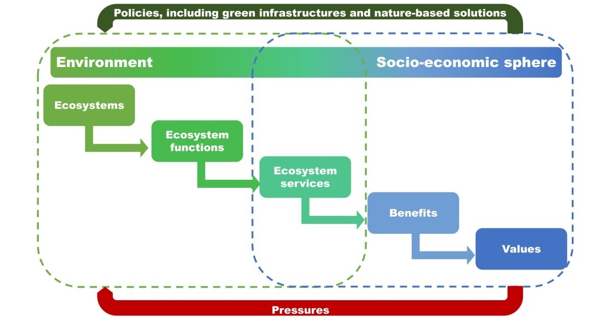
The conceptual category of ecosystem service (ES) was pioneered in the 1970s by articles that identified connections between the life quality of human settlements and the social and economic positive effects of ecosystems. Thenceforward, several studies have identified ESs as important public goods and, as a consequence, the concept of ES has progressively gained relevance as regards the ecological, economic and spatial planning scientific and technical profiles.

A significant general research question is to consider ESs as value-generating resources and to assess their use within the implementation of public policies. From this standpoint, ESs can be associated to the benefits that human settlements, either directly or indirectly, enjoy from nature, and to the support offered by the natural environment to the enhancement of the life quality of human societies. At the outset of the 21st century, the Millennium Ecosystem Assessment defined a taxonomy of ESs by stating that ESs “[A]re the benefits people obtain from ecosystems. These include provisioning services such as food and water; regulating services such as regulation of floods, drought, land degradation, and disease; supporting services such as soil formation and nutrient cycling; and cultural services such as recreational, spiritual, religious and other nonmaterial benefits.” Thereafter, a number of classifications have been proposed by several international bodies and discussed in many studies. Outstanding comprehensive scientific and technical issues in the spatial planning debate can be identified by the analysis and assessment of trade-offs between the protection of nature and economic growth, and between the provisions of different kinds of ESs.

The conceptual category of green infrastructure (GI) is strictly related to ES. According to the European Commission, a GI is “[A] strategically planned network of natural and semi-natural areas with other environmental features designed and managed to deliver a wide range of ESs. It incorporates green spaces (or blue if aquatic ecosystems are concerned) and other physical features in terrestrial (including coastal) and marine areas. On land, GI is present in rural and urban settings,” and, “The work done over the last 25 years to establish and consolidate the network means that the backbone of the European Union’s GI is already in place. It is a reservoir of biodiversity that can be drawn upon to repopulate and revitalize degraded environments and catalyze the development of GI. This will also help reduce the fragmentation of the ecosystems, improving the connectivity between sites in the Natura 2000 network and thus achieving the objectives of Article 10 of the Habitats Directive.” (SWD(2013) 155 final). This indicates that, according to the European Commission, environmental conservation and improvement are closely connected to the quality of GI as a provider of ESs, and that public policies should give priority to the management, enhancement and monitoring of GI as an ecological network that not only supplies multiple ESs, but also implements their spatial connectivity.

The conceptual category of Nature-based solutions (NBSs) is strictly linked to ES. NBSs are policy measures which build on nature and natural resources, designed and implemented to recover and improve ecosystems’ quality, and to support human societies in order to increase their resilience to climate change. NBSs are generally aimed at decreasing water run-offs, land-surface and air temperature in highly urbanized areas, and at generating positive impacts on environmental, economic and social spatial contexts. NBSs identify a conceptual framework which embeds a number of methodologies addressing many spatial issues. Important among these are the approaches based on the selection and management of ESs and GIs; the planning and governance of spatial processes aimed at supplying ESs; measures to increase water-holding capacity and purification in natural environments; and policies related to the afforestation, reforestation, and sustainable management of forests and woodland. NBSs are increasingly being embedded into the international, national, and local policies that address the negative impacts of climate change and related environmental hazards thereof, although these issues imply relevant technical expertise and insights in order to make NBSs fully operational as regards the thematic questions and spatial contexts at stake.

This Special Issue focuses on ecosystem services, green infrastructure, and Nature-based solutions as important reference points for spatial planning related to urban and rural contexts, with particular reference to the definition and implementation of planning policies aimed at protecting nature and natural resources.

Theoretical and methodological contributions as well as critical discussions on policy implementation are welcome, with particular reference to the following issues:

1) Integration of ESs within spatial plans and strategic environmental assessment:

  • What function do ESs play, or could ESs play, within plan-making processes and strategic environmental assessments?
  • At which stage of the planning process is such integration most useful or effective?
  • What are the most important challenges in putting integration into practice, and/or the most significant obstacles to achieving integration?
  • What roles do scientific and technical expertise vs. community values and local knowledge play in integrating ESs within spatial plans and environmental assessments?

2) Consideration and use of GIs within spatial plans:

  • What function do GIs play, or could GIs play, within plan-making processes?
  • What criteria are most effective for designing a spatially connected and multifunctional GI within a spatial plan?
  • What kinds of spatial plans (land-use plans, landscape plans, basin plans etc.), are most suited for, or most effective in, designing and implementing GIs?
  • Does scale (local, regional, etc.) make a difference in the way GIs are implemented within spatial plans?

3) Relationship between NBSs and spatial plans:

  • Since NBSs are increasingly promoted at the very strategic level (i.e., that of broad policies) and implemented at a very detailed level (i.e., that of projects), what is the role of NBSs within spatial plans?
  • What tools are at planners’ disposal to effectively integrate NBSs in planning processes and promote their use, especially in urban contexts?

Prof. Dr. Corrado Zoppi
Prof. Dr. Sabrina Lai
Guest Editors

Manuscript Submission Information

Manuscripts should be submitted online at www.mdpi.com by registering and logging in to this website. Once you are registered, click here to go to the submission form. Manuscripts can be submitted until the deadline. All submissions that pass pre-check are peer-reviewed. Accepted papers will be published continuously in the journal (as soon as accepted) and will be listed together on the special issue website. Research articles, review articles as well as short communications are invited. For planned papers, a title and short abstract (about 100 words) can be sent to the Editorial Office for announcement on this website.

Submitted manuscripts should not have been published previously, nor be under consideration for publication elsewhere (except conference proceedings papers). All manuscripts are thoroughly refereed through a single-blind peer-review process. A guide for authors and other relevant information for submission of manuscripts is available on the Instructions for Authors page. Sustainability is an international peer-reviewed open access semimonthly journal published by MDPI.

Please visit the Instructions for Authors page before submitting a manuscript. The Article Processing Charge (APC) for publication in this open access journal is 2400 CHF (Swiss Francs). Submitted papers should be well formatted and use good English. Authors may use MDPI's English editing service prior to publication or during author revisions.

Keywords

  • ecosystem services
  • natural capital
  • green infrastructures
  • ecological networks
  • nature-based solutions
  • spatial planning
  • land-use planning

Published Papers (12 papers)

Order results
Result details
Select all
Export citation of selected articles as:

Editorial

Jump to: Research

4 pages, 174 KiB  
Editorial
Sustainable Spatial Planning Based on Ecosystem Services, Green Infrastructure and Nature-Based Solutions
by Sabrina Lai and Corrado Zoppi
Sustainability 2024, 16(6), 2591; https://doi.org/10.3390/su16062591 - 21 Mar 2024
Viewed by 557
Abstract
In the last decade, ecosystem services, that is, the goods and benefits provided by ecosystems to people, have gained significant importance in the planning domain, as a consequence of the growing scholarly awareness about, and interest in, the complex relationship between human well-being [...] Read more.
In the last decade, ecosystem services, that is, the goods and benefits provided by ecosystems to people, have gained significant importance in the planning domain, as a consequence of the growing scholarly awareness about, and interest in, the complex relationship between human well-being and nature [...] Full article

Research

Jump to: Editorial

17 pages, 2723 KiB  
Article
Managing Complex Knowledge in Sustainable Planning: A Semantic-Based Model for Multiagent Water-Related Concepts
by Mauro Patano and Domenico Camarda
Sustainability 2023, 15(15), 11774; https://doi.org/10.3390/su151511774 - 31 Jul 2023
Viewed by 655
Abstract
The concepts of green infrastructures, nature-based solutions and ecosystem services are today considered an integral part of the broader theme of the urban bioregion, with an intrinsic character of complexity. It is certainly difficult to structure bioregional processes in a balanced and sustainable [...] Read more.
The concepts of green infrastructures, nature-based solutions and ecosystem services are today considered an integral part of the broader theme of the urban bioregion, with an intrinsic character of complexity. It is certainly difficult to structure bioregional processes in a balanced and sustainable way, able to keep local energy production and consumption cycles closed. It is a complex issue of knowledge bases, and problems are increased by the participatory dimension of environmental planning. In fact, when rational planning models have failed in the face of prominent individual needs and environmental complexity, a path has emerged towards the inclusion of multiple citizens’ and stakeholders’ knowledge. The cognitive structure of the plans has thus changed from systems of exclusively expert, formal knowledge to systems of diffused, multi-agent knowledge. This has involved richness but also significant problems in understanding and managing knowledge bases. In this complexity, there are some common peculiarities when it comes to socio-environmental systems. A common feature of the reference domains of ecosystem services, nature-based solutions and green infrastructures is the water resource. A management model of hydrological data, which are structurally relevant and cross-sectoral in environmental planning actions, could represent a flagship initiative. The used approach could be conveyed to more complex and extensive areas of the environmental domain in a perspective of sustainable planning. The present paper is part of a research work oriented toward handling complex environmental subjects, such as green infrastructures, nature-based solutions or ecosystem services, with a knowledge modelling approach. This approach is based on semantic extensions, elaborated form the concept of semantic web, to allow shared interpretations of knowledge coming from different languages and scientific domains. It is also based on using applied ontologies, elaborated from the concept of ontology-based classification, to support a structured organization of knowledge contents. The main research objective is therefore to investigate about a knowledge management system with semantic extensions, populated with hydrological knowledge contents, as well as to propose a preliminary functional architecture. A simple ontology of data is extracted, aiming at clarifying and improving inter-domain communication, so as to enhance a common semantic understanding in a complex environmental system. Full article
Show Figures

Figure 1

25 pages, 2979 KiB  
Article
An Operational Model to Downscale Regional Green Infrastructures in Supra-Local Plans: A Case Study in an Italian Alpine Sub-Region
by Guglielmo Pristeri, Viviana di Martino, Silvia Ronchi, Stefano Salata, Francesca Mazza, Andrea Benedini and Andrea Arcidiacono
Sustainability 2023, 15(15), 11542; https://doi.org/10.3390/su151511542 - 26 Jul 2023
Viewed by 956
Abstract
In recent years, green infrastructure (GI) has increasingly become a strategic tool to integrate ecosystem services in spatial planning at different scales. GI has the potential to foster the achievement of environmental targets and landscape enhancement promoted by several planning instruments that act [...] Read more.
In recent years, green infrastructure (GI) has increasingly become a strategic tool to integrate ecosystem services in spatial planning at different scales. GI has the potential to foster the achievement of environmental targets and landscape enhancement promoted by several planning instruments that act at different territorial scales. Despite this, the combination of the GI strategy with other ordinary plans is poorly investigated and developed due to the difficulty in making planning instruments dialoguing in a transversal approach. This paper presents a case study in an Italian alpine sub-region (Media and Alta Valtellina, Province of Sondrio) focused on a regional GI—defined by a landscape plan—used for testing a replicable methodology to downscale regional strategies by combining them with sub-regional environmental and landscape rules and recommendations derived from planning instruments. The aim is to create an organic connection between GI goals and other sub-regional planning instruments that would otherwise remain siloed within the hierarchical downscaling process of the top-down planning system. The result is the development of a comprehensive matrix that is useful for downscaling the strategies established by a regional landscape plan in sub-regional landscape units that relapse at the local scale; this is also achieved through GI deployment and the promotion of site-specific nature-based solutions. Full article
Show Figures

Graphical abstract

11 pages, 2209 KiB  
Article
Ecosystem Services for the City as a Complex System: A Methodological Proposal
by Romano Fistola
Sustainability 2023, 15(12), 9318; https://doi.org/10.3390/su15129318 - 09 Jun 2023
Cited by 1 | Viewed by 1061
Abstract
Originating from the main theories on the interpretation of the city as a system, this paper calls attention to the need to build a new theoretical framework. This framework would be able to support actions related to the consideration of ecosystem services in [...] Read more.
Originating from the main theories on the interpretation of the city as a system, this paper calls attention to the need to build a new theoretical framework. This framework would be able to support actions related to the consideration of ecosystem services in the activities governing urban and territorial transformations. By adopting the systemic interpretation of the city, it may be possible to more readily identify the ecosystem services related to each of the urban subsystems, and promote a new and different consideration of them when defining urban policies on the sustainable management of urban and territorial systems. This reflection describes a new approach to the problem, by indicating mainly the theoretical references and methodological connections to be considered in the development of a new dimension of territorial government. This dimension would be, by necessity, built upon issues that characterize the current historical phase, such as ecological transition, and the new potential of technological innovation that, if properly reconsidered, could contribute to substantially redefining the field of traditional urban planning. Full article
Show Figures

Figure 1

29 pages, 10233 KiB  
Article
A Method Proposal to Adapt Urban Open-Built and Green Spaces to Climate Change
by Carmela Gargiulo and Floriana Zucaro
Sustainability 2023, 15(10), 8111; https://doi.org/10.3390/su15108111 - 16 May 2023
Cited by 2 | Viewed by 2198
Abstract
To rapidly adapt cities to the growing impacts of climate change, the open space system can play important functions as climate regulators and accelerators of sustainable urban development. To this end, this paper aims to provide a methodology that classifies open spaces on [...] Read more.
To rapidly adapt cities to the growing impacts of climate change, the open space system can play important functions as climate regulators and accelerators of sustainable urban development. To this end, this paper aims to provide a methodology that classifies open spaces on the basis of their physical characteristics and their contribution to climate vulnerability and articulates them according to the costs required for adaptation and the benefits brought. The method was applied to the city of Naples, which is an interesting case study due to its heterogeneous territory in terms of geomorphological features, such as hilly conformation and coastal location, and urban assets characterised by densely built urban fabrics with different distributions and kinds of activities. The results showed that (i) the open spaces with both low thermal and hydraulic performance are predominantly located in the peripheral part of the city, and (ii) the central area is strongly characterised by this dual issue. The latter output confirms the need to update the transformation rules of high historical-architectural value areas by introducing new resilience requirements criteria that cities are asked to have. Full article
Show Figures

Figure 1

28 pages, 2542 KiB  
Article
A Contingent Valuation-Based Method to Valuate Ecosystem Services for a Proactive Planning and Management of Cork Oak Forests in Sardinia (Italy)
by Luigi La Riccia, Vanessa Assumma, Marta Carla Bottero, Federico Dell’Anna and Angioletta Voghera
Sustainability 2023, 15(10), 7986; https://doi.org/10.3390/su15107986 - 13 May 2023
Cited by 3 | Viewed by 1637
Abstract
The paper develops a model through a contingent valuation approach to support public authorities in the exploration and assessment of ecosystem services (ESs) generated by forest and woodlands (FOWLs). This approach is employed to the cork oak forests of the Sardinia region (Italy) [...] Read more.
The paper develops a model through a contingent valuation approach to support public authorities in the exploration and assessment of ecosystem services (ESs) generated by forest and woodlands (FOWLs). This approach is employed to the cork oak forests of the Sardinia region (Italy) due to their ability in the provision and regulation of cultural and recreational values to society. The paper describes the economic valuation of cultural ESs through the contingent valuation method (CVM) with the purpose to explore residents and tourists’ willingness to pay (WTP) preferences towards conservation, valorisation, and the management of Goceano’s cork oak forests in Sardinia. The approach may help retain suitable support for DMs, planners, technicians, and operators for a better understanding of the ESs’ role in policy decisions, leading FOWLs towards a learning process between the environment, human beings, and landscape to promote and develop a proactive landscape and forest planning and management within the region. Full article
Show Figures

Figure 1

18 pages, 20863 KiB  
Article
High-Resolution Greening Scenarios for Urban Climate Regulation Based on Physical and Socio-Economical Factors
by Daniele La Rosa and Junxiang Li
Sustainability 2023, 15(9), 7678; https://doi.org/10.3390/su15097678 - 07 May 2023
Viewed by 1528
Abstract
Urban ecosystems represent the main providers of ecosystem services in cities and play a relevant role, among the many services, in the regulation of the urban microclimate and mitigation of the urban heat island effect. The amount, localization, and spatial configuration of vegetation [...] Read more.
Urban ecosystems represent the main providers of ecosystem services in cities and play a relevant role, among the many services, in the regulation of the urban microclimate and mitigation of the urban heat island effect. The amount, localization, and spatial configuration of vegetation (i.e., urban trees) are key elements for planners and designers aiming at maximizing the climate regulation potential and therefore extending the related benefits to a higher number of residents and city users. Different factors and constraints related to urban morphology and socio-economical characteristics of the urban environment influence the localization of new greening scenarios, therefore impacting the potential benefits that can be obtained by residents. This paper investigates these factors by identifying high-resolution greening scenarios that are able to maximize the cooling benefits for people and local residents. For the case study of metropolitan areas of Catania (Italy) with a hot Mediterranean climate, scenarios are derived by modelling physical and socio-economic factors as spatial constraints with the UMEP model and GIS spatial analysis. Results show that new greenery should be mostly located in public areas that are mostly used by residents. Built on the results obtained in the case study analyzed, the paper also proposes some general planning criteria for the localization of new urban greenery, which should be extended to other geographical urban contexts. Full article
Show Figures

Figure 1

14 pages, 4176 KiB  
Article
Effects of Urban Planning on Ecosystem Services: The Umbria Region Seismic Crater
by Chiara Cattani, Cristina Montaldi, Gianni Di Pietro and Francesco Zullo
Sustainability 2023, 15(9), 7674; https://doi.org/10.3390/su15097674 - 07 May 2023
Cited by 1 | Viewed by 1520
Abstract
The earthquake in central Italy in 2016 led to a profound urban and natural landscape transformation. The role of territorial planning in this kind of situation is extremely important because it allows the orientation of future settlement choices through appropriate interpretative keys of [...] Read more.
The earthquake in central Italy in 2016 led to a profound urban and natural landscape transformation. The role of territorial planning in this kind of situation is extremely important because it allows the orientation of future settlement choices through appropriate interpretative keys of the existing territorial dynamics. This work aims to analyze the effects of the planning choices made in the post-earthquake period in the seismic crater municipalities of the Umbria region. Using the InVEST models, these studies regard the comparison of the effects of in-force plans on ecosystem services such as habitat quality and carbon storage. The data about the mosaic of the municipal urban planning tools are derived from specific actions produced under two LIFE projects (SUNLIFE and IMAGINE). The comparison makes it possible to identify how and to what extent the transformative scenarios, linked to the new condition, change the spatial planning compared to the previous one and the effects on the provision of ecosystem services. The knowledge of the latter aspect allows optimization of the methods of urban transformation that will be implemented. Moreover, this process of optimizing the provision of essential ecosystem services could certainly play a key role in the enhancement and economic recovery of these areas. Full article
Show Figures

Figure 1

24 pages, 4725 KiB  
Article
Green Infrastructure and Slow Tourism: A Methodological Approach for Mining Heritage Accessibility in the Sulcis-Iglesiente Bioregion (Sardinia, Italy)
by Mara Ladu, Silvia Battino, Ginevra Balletto and Ainhoa Amaro García
Sustainability 2023, 15(5), 4665; https://doi.org/10.3390/su15054665 - 06 Mar 2023
Cited by 3 | Viewed by 2506
Abstract
In European countries many measures are carried out to improve the disadvantaged conditions and socio-economic marginality of rural areas in comparison with central places. These conditions also affect the quality of travel for visitors and tourists. Therefore, in response to a ‘new’ tourist [...] Read more.
In European countries many measures are carried out to improve the disadvantaged conditions and socio-economic marginality of rural areas in comparison with central places. These conditions also affect the quality of travel for visitors and tourists. Therefore, in response to a ‘new’ tourist demand, motivated also by the restrictions following the spread of the COVID-19 virus in recent years, the institutions and the different local actors are working more incisively to improve rural areas. The rural tourism services offer, combined with the Green Infrastructure (GI) project, at different scales—from local to regional—interesting territorial development strategies to achieve the Agenda 2030 objectives. This contribution considers the Sulcis-Iglesiente-Guspinese area, in the Sardinia Region (IT), as a case study. In this area, the landscape context is marked by past mining activity, and the project of a path of historical, cultural, and religious values has proven to be an activator of regenerative processes, in environmental, social, and economic terms. The present study proposes a methodological approach to develop an index (FI—feasibility index) to assess the feasibility of the Stop Places (SPs) project along a horse trail to integrate the current slow mobility of bicycles and pedestrians in the bioregion. Full article
Show Figures

Figure 1

18 pages, 1450 KiB  
Article
Italy vs. Poland: A Comparative Analysis of Regional Planning System Attitudes toward Adaptation to Climate Changes and Green Infrastructures
by Antonio Ledda, Marta Kubacka, Giovanna Calia, Sylwia Bródka, Vittorio Serra and Andrea De Montis
Sustainability 2023, 15(3), 2536; https://doi.org/10.3390/su15032536 - 31 Jan 2023
Cited by 3 | Viewed by 14841
Abstract
European spatial planners deal with two major concerns: adaptation to climate changes (ACC) and the design and management of green infrastructures (GIs). ACC calls for the renewal of spatial planning with constant appeals to the need to adequately prepare for extreme climate events. [...] Read more.
European spatial planners deal with two major concerns: adaptation to climate changes (ACC) and the design and management of green infrastructures (GIs). ACC calls for the renewal of spatial planning with constant appeals to the need to adequately prepare for extreme climate events. GIs deliver ecosystem services (ES), which consist of beneficial functions to living beings in terms of, for example, helping people adapt to climate change. An effective implementation of adaptation measures at the regional and sub-regional scale is based on an efficient and prompt spatial planning system and GIs management. In this paper, we aim at comparing the attitudes of Italian and Polish spatial planning systems with respect to the integration of concepts related to ACC and GIs. We describe commonalities and differences between the two spatial planning frameworks by scrutinizing regional plans adopted in Sardinia (Italy) and Wielkopolska (Poland). We found out a scarce consideration of both ACC and GIs planning and management. The findings suggest that the regional spatial planning tools need to be updated to be fully satisfactory in terms of ACC and GIs concepts. Full article
Show Figures

Figure 1

22 pages, 2351 KiB  
Article
Strengthening a Regional Green Infrastructure through Improved Multifunctionality and Connectedness: Policy Suggestions from Sardinia, Italy
by Federica Isola, Sabrina Lai, Federica Leone and Corrado Zoppi
Sustainability 2022, 14(15), 9788; https://doi.org/10.3390/su14159788 - 08 Aug 2022
Cited by 8 | Viewed by 2182
Abstract
A wide body of research in recent years has studied either green infrastructures as providers of multiple ecosystem services, especially at the urban level, or ecological corridors and the issue of connectivity between landscape patches in the face of growing fragmentation. However, not [...] Read more.
A wide body of research in recent years has studied either green infrastructures as providers of multiple ecosystem services, especially at the urban level, or ecological corridors and the issue of connectivity between landscape patches in the face of growing fragmentation. However, not many studies have analyzed how the two concepts can be combined to ground evidence-based policy and planning recommendations. In this study, a methodological approach for such a combination is proposed: after mapping a regional green infrastructure building upon the assessment of multiple ecosystem services and a network of ecological corridors through the resistance to movement of species, the two spatial layouts are combined so as to analyze correlations between the potential provision of ecosystem services and the resistance to movement. The methodology is applied in the case of the island of Sardinia, whose self-containment makes it possible to discard potential effects from surrounding areas, hence facilitating the implementation of the model. The outcomes of the regression model point out three ecosystem services as the most important factors that should be targeted by appropriate spatial policies if connectivity is to be increased: regulation of micro and local climate, forestry productivity, and cultural identity and heritage values. Full article
Show Figures

Figure 1

31 pages, 8269 KiB  
Article
Mapping of Ecological Corridors as Connections between Protected Areas: A Study Concerning Sardinia, Italy
by Federica Isola, Federica Leone and Corrado Zoppi
Sustainability 2022, 14(11), 6588; https://doi.org/10.3390/su14116588 - 27 May 2022
Cited by 3 | Viewed by 2256
Abstract
According to the European Commission, green infrastructure and spatial connectivity concerning the provision of ecosystem services are strictly related to the conceptual category of ecological networks. In particular, regional and urban planning processes should adequately manage, improve and monitor the effectiveness of green [...] Read more.
According to the European Commission, green infrastructure and spatial connectivity concerning the provision of ecosystem services are strictly related to the conceptual category of ecological networks. In particular, regional and urban planning processes should adequately manage, improve and monitor the effectiveness of green infrastructures as ecological networks which provide ecosystem services and the spatial connectivity of such systems. Building on a methodological approach defined in previous studies, this article aims at identifying ecological corridors through a least-cost path model with reference to the spatial layout of a set of protected areas. Moreover, such a methodological approach is implemented in the context of the Sardinian region to map ecological corridors, which form, together with protected areas, a network representing the spatial framework of regional green infrastructure. Finally, the study discusses the relation between ecological corridors and the spatial taxonomy of the landscape components featured by environmental relevance, identified by the Regional Landscape Plan, through multiple linear regression analysis, in order to assess if, and to what extent, the present regional spatial zoning code can be used as a basis to implement regulations aimed at protecting ecological corridors. This methodological approach is relevant to defining planning policies and measures to strengthen the operational capacity and effectiveness of regional networks of protected areas through the protection and the improvement of the spatial framework of ecological corridors. Full article
Show Figures

Figure 1

Back to TopTop