Article

Green Infrastructure and Slow Tourism: A Methodological Approach for Mining Heritage Accessibility in the Sulcis-Iglesiente Bioregion (Sardinia, Italy)

1
Department of Civil, Environmental Engineering and Architecture, University of Cagliari, 09123 Cagliari, Italy
2
Department of Economics and Business Management, University of Sassari, 07100 Sassari, Italy
3
Instituto Universitario de Turismo y Desarrollo Económico y Sostenible, University of Las Palmas de Gran Canaria, 35001 Las Palmas, Spain
*
Author to whom correspondence should be addressed.
Sustainability 2023, 15(5), 4665; https://doi.org/10.3390/su15054665
Submission received: 2 February 2023 / Revised: 2 March 2023 / Accepted: 4 March 2023 / Published: 6 March 2023

Abstract

:
In European countries many measures are carried out to improve the disadvantaged conditions and socio-economic marginality of rural areas in comparison with central places. These conditions also affect the quality of travel for visitors and tourists. Therefore, in response to a ‘new’ tourist demand, motivated also by the restrictions following the spread of the COVID-19 virus in recent years, the institutions and the different local actors are working more incisively to improve rural areas. The rural tourism services offer, combined with the Green Infrastructure (GI) project, at different scales—from local to regional—interesting territorial development strategies to achieve the Agenda 2030 objectives. This contribution considers the Sulcis-Iglesiente-Guspinese area, in the Sardinia Region (IT), as a case study. In this area, the landscape context is marked by past mining activity, and the project of a path of historical, cultural, and religious values has proven to be an activator of regenerative processes, in environmental, social, and economic terms. The present study proposes a methodological approach to develop an index (FI—feasibility index) to assess the feasibility of the Stop Places (SPs) project along a horse trail to integrate the current slow mobility of bicycles and pedestrians in the bioregion.

1. Introduction

According to UNWTO, rural tourism is a “type of tourism activity in which the visitor’s experience is related to a wide range of products generally linked to nature-based activities, agriculture, rural lifestyle/culture, angling and sightseeing” [1]. This type of tourism can be combined with the slow philosophy of travel that suggests a non-invasive and sustainable use of space. Slow tourism is a way of traveling focused on in-depth experience to understand the ecosystem of places and the landscapes in progress, with a limited impact on the environment, especially when the community chooses to travel by sustainable transport models (walk, bike, horse) [2,3]. In the rural context, this approach is a priority for local actors who are planning their landscapes under the banner of economic competitiveness and the protection of natural and cultural resources. Slow movement normally takes place along specially created or ‘recovered’ paths that represent the essence of the place. The rediscovery of identity traces and the consequent development of projects consider the territory as a common resource/service on which the well-being and quality of life of the resident and host population depends. In this profile, the value of common pool resources is combined with that of green infrastructures that assume the role of ‘glue’ between natural and semi-natural areas, and agricultural and built-up areas.
Green infrastructures (GIs), at the local scale, prove to be increasingly strategic in achieving the objectives of the 2030 Agenda. According to the European Commission (EC), a GI is “a strategically planned network of natural and semi-natural areas with other environmental features designed and managed to deliver a wide range of ecosystem services [4]. It incorporates green spaces—or blue ones if aquatic ecosystems are concerned—and other physical features in terrestrial—including coastal—and marine areas” [5]. Moreover, GIs can provide multiple environmental, social, and economic benefits. These include paths and other infrastructures for slow mobility.
The EU’s Green Infrastructure Strategy (2019) [6] confirms that the connection of natural capital in Europe is to be strengthened. In this sense, the quality of the GIs, understood as a provider of ecosystem services (ESs) and as a system well integrated and spatially connected, has a significant effect on the conservation and improvement of the environment [7]. This is why integrating the GI objectives into strategic planning processes and spatial planning tools is an absolute priority [8].
Another aspect to consider is that the projects of paths and cycle paths, which constitute the network to favor slow mobility [9], contribute to the realization of GIs, recognized as drivers of territorial regeneration.
This is what is emerging in the Sulcis-Iglesiente bioregion, located in the south-western part of the Autonomous Region of Sardinia (Sardinia Region) in Italy. This area went through a phase of economic conversion based on sustainable slow tourism development [10,11,12], as a result of abandoned mines [13].
Within this framework, the objective of this manuscript is to define a methodological approach to develop a feasibility index (FI) to assess the feasibility of the Stop Places (SPs) project scenarios along a horse trail to integrate current slow mobility methods (walking and biking), improving accessibility to the mining heritage. The paper is organized as follows:
  • First section—Introduction and Literature Review—focuses on the overview of the recent literature of GI and of its integration with slow tourism and bioregion concepts;
  • Second section—Materials and Data—discusses the topic of green infrastructures and slow mobility in the Sulcis-Iglesiente region and presents principles and approaches for horse trails planning;
  • Third section—Methodology—proposes a methodological approach to assess the feasibility of the Stop Places (SPs) scheme along a horse trail;
  • Fourth section—Case Study—is dedicated to the methodology application in the Stop Places (SPs) along a horse trail in the Sulcis-Iglesiente bioregion;
  • Fifth section—Results—reports and discusses the main research results carried out.
  • Sixth section—Discussion—discusses the major findings within the framework derived from the literature review;
  • Seventh section—Conclusion and Future Development—is dedicated to the conclusions together with the future developments of the research.

1.1. Rural and Slow Tourism—Green Infrastructure

Composing 83% of the total land area of the European Union (EU), the rural world is home to some 137 million inhabitants (30% of the total population) and is characterized by its landscape diversity. These diversities are also expressed through multiple weaknesses linked to depopulation and a weak socio-economic network. In the last twenty years, in order to counteract the elements that increase the peripherality of these areas in relation to urbanized areas, Europe has outlined an agenda of action plans and programs focused on growth, employment, and the sustainable development of spaces. However, the implementation of Agenda 2000 has also triggered several reforms of development and cohesion policies in the agricultural sector, which has seen a new model based on the multifunctionality of the rural territory [14,15,16]. In particular, the diversification of the rural economy, in addition to placing the agricultural production sector in a new framework, has made it possible to address with greater attention the critical issues related to environmental protection and the quality of life of native communities [17]. In addition, as a result of the restrictions of the COVID-19 pandemic, the EU supports the rural world through the European Agricultural Fund for Rural Development 2021–2027 (EAFRD): funding that can be spent by the different Rural Development Programs (RDPs) at national and regional levels to foster inclusive, cohesive, and sustainable development [18].
The opportunities for rural territories to improve local development can be seized in the diversified panorama of sustainable tourism activities. In particular, rural tourism explicated in different forms according to the territory and the communities that are involved in it is prefigured as a tool for the conservation of the landscape and the growth of the socio-economic value of places through a structured offer of goods and services [19,20]. There is no universal definition of rural tourism and through the years there have been many definitions enunciated that differ based on the aspects considered, such as socio-cultural, administrative, demographic, and economic [21]. In 1998, the European Commission defined rural tourism as “…the activities of a person travelling and staying in rural areas—without mass tourism—other than those of their usual environment for less than one consecutive year for leisure, business and other purposes (excluding the exercise of an activity remunerated from within the places visited” [22]. The multifunctional organization of the rural space thus acquires a new guise where synergies between local operators (public and private) can be expressed through cultural, environmental, sporting, and educational initiatives planning, which also holds all the benefits deriving from the implementation of multimodal transport for the accessibility of tourist destinations, according to the MAAS (mobility as a service) perspective, where the public transport system is the more ecologically and socially sustainable [23,24].
The activation of this integrated offer plays a fundamental role in the processes of revitalization and local development because it makes it possible to preserve the territorial identity of the many rural villages and, at the same time, allows tourists to enjoy an ‘experiential’ journey [25,26,27]. According to Eurostat data, in 2021, in the 27 Member States, 36% of tourist nights were spent in rural areas, which offers around 12 million beds [28]. The choice of a holiday in contact with nature and the authenticity of places is even more motivated by the changes brought to daily life by the COVID-19 pandemic. Health insecurity and restrictions have prompted tourists to seek ‘staycation’ and ‘slow’ travel experiences [29,30,31,32]. Thus, in response to the criticality of overtourism, rural tourism experiences are combined with the slow philosophy (slow tourism). This last trend, born with the ‘slow food’ movement, allows us to deepen our knowledge of places by perceiving their most authentic aspects. The enjoyment of landscape assets, the respect for the environment, and the propensity to use sustainable means of transport are just some of the fundamental characteristics of ‘slow’ travel—walking, cycling, horseback riding, etc. [2,3]. Furthermore, the experience of slow travel is completed when visitors and tourists choose to travel through destinations following sustainable infrastructures. In this context, the scientific debate on GIs began to appear in the 1990s and, today, the term plays a key role in policies and strategies aimed at resolving critical environmental issues [33]. Following the debates, several definitions of GIs have been enunciated [34,35]. The European Commission, since 2013, has launched a special strategy to support the green economy through the development of GIs, and has defined them as: “Green Infrastructure can be broadly defined as a strategically planned network of high quality natural and semi-natural areas with other environmental features, which is designed and managed to deliver a wide range of ecosystem services and protect biodiversity in both rural and urban settings. More specifically GI, being a spatial structure providing benefits from nature to people, aims to enhance nature’s ability to deliver multiple valuable ecosystem goods and services, such as clean air or water” [36]. The Commission published two further guidance documents in 2019 to encourage a more integrated approach and increase investment and planning in this field. These documents reinforce the idea that the sites included in the Natura 2000 Network represent the core of the GI strategy to which were added “[…] biodiversity-rich green spaces such as parks, private gardens, hedges and vegetated buffer strips along rivers or structure-rich agricultural landscapes with certain features and practices, and artificial features such as green roofs, green walls, or eco-bridges and fish ladders […]” [37].
GI takes the form of an interconnected network of spaces (urban, peri-urban, and rural) of significant environmental, cultural, and visual value. Although the scientific debate on the types of areas that can contribute to the realization of a GI is still in constant evolution [38], it is believed that its function is to simultaneously preserve and provide environmental services to affected communities, which include, for example, biodiversity and wildlife, mitigation of air quality, recreation, environmental beauty, and protection of disasters [34,39].
Investing in GIs completes the European program “Biodiversity strategy for 2030” [40], activated to protect member states’ biodiversity. The roadmap for rural spatial planning therefore requires the creation of an ecosystem network where green goods and grey goods and services are integrated in a sustainable way [41,42]. GIs have an ecological, cultural, social, and economic function: the resident community is motivated to follow a healthy lifestyle, which includes the adoption of sustainable and slow mobility and the possibility of creating spaces of ‘community friendliness’ more in contact with the natural element [43].

1.2. Bioregion and Sardinia Mining Landscape

The GI plan to provide a network of ‘new’ ecosystem services is part of the vision of the bioregion [44,45]. This term originated in the 1970s along the American West Coast. The authors Peter Berg and Raymond Dasmann (1977) [46] can be defined as the fathers of the concept and the consequent alternative approach that sees localism as an opportunity to safeguard landscapes. The bioregion is defined as a geographical space and ‘place of consciousness’ in which environmental sustainability, knowledge, and conscious management of resources allows for a ‘re-inhabitation of place’, as introduced by Berg in his studies [47]. An environmentalist vision that has since developed in other countries and, in the Italian case [48], thanks to the territorialist studies of Magnaghi [49,50]. The bioregion project idea requires an integrated, multidisciplinary approach at different scales capable of strengthening the cultural identity of the area networks while creating a dynamic balance between the different rural and urban centers [51] and material and immaterial dimensions [52]. Thus, bioregionalism, in its capacity as a territorial regeneration project, qualifies as an essential paradigm for addressing the critical issues of rural areas.
The island of Sardinia represents, due to its environmental characteristics, a peculiar condition: the geological, paleontological, and mineralogical elements, biological rarities and endemisms, forest stands and wetlands, spectacular natural landscapes in the morphology of the coasts and of the internal reliefs, the underground cavities and the archaeological finds all make it a small but whole continent. Sardinia is famous in the international mining world for the richness of its geology, of its ore deposits and of its mines [53]. On the 24,000 square kilometers that make up the area of this island, all the geological eras, from the late Precambrian onwards, are represented through an enormous variety of heterogeneous rocks, minerals, and fossils. The mining vocation of Sardinia is manifested in the large number of scattered mines on the entire surface of the island, of different productive, scientific, and cultural value, but all indispensable for understanding the extraordinary evolution of events, which, in more than 8000 years of uninterrupted events, have marked the history of the use of the territory by man [54].
From the lower Paleozoic up to the present, mineral genetic processes have developed, producing the concentration of metals and minerals of industrial interest in deposits of different types, genesis, and entity. The orogenetic events and the imposing granitic intrusions have activated hydrothermal circuits, with depositions of various types of mineralization, such as talc-chlorite and mineralizations with magnetite and sulphide. The deposition of carbonate sediments starting from the Jurassic, was completed at the end of the Mesozoic, when Sardinia emerged completely and several layers of coal deposited in the south-western area (Sulcis), combined in a calcareous-marly succession. The importance of each area, within the framework of mining sites, is related to the development of a particular mineral deposit: from the metalliferous ore deposits to the presence of the important copper mining (Funtana Raminosa), which played a significant role in the history of metallurgy in the Mediterranean area, starting from the Neolithic age. From the zinc and silver metal deposits, exploited since the Roman colonization, to the metallic antimony deposits, exploited since the Phoenician and Punic invasions, which made the area of Sarrabus-Gerrei the second island mining district between 1800 and 1900. The most important mines are present in the so-called “metal ring of the Iglesiente”, where lead, silver, and zinc mineralizations are located in the carbonatic geological formations which, at over 500 million years old, are the oldest paleontological dated rocks in Italy.
The mining activity of Sardinia has primarily involved the communities that have followed one another in the exploitation of subsoil resources; the traces of this industry, which has been influenced by the same historical events of the island, are clearly visible in the territory. It has undergone profound changes that currently characterize it. The features of the natural landscape are visibly marked by the material culture, social organizations, and settlements that have arisen around the mining activities, which have generated new and original forms of landscape and social and cultural environments, such as to characterize vast areas with a precise identity of universal value, unique and representative of the entire Mediterranean geo-cultural region. Considering all these values, the Sardinia Region, through the Sardinian Mining Authority, has intended to promote, starting from 1997, with the involvement of all institutional subjects authorities, first of all the Local Authorities concerned, the establishment of the Historical Environmental Geo-Mining Park of Sardinia (Geo-Mining Park) [55], which includes the most important mining districts, located in the Sulcis-Iglesiente-Guspinese, but also the most significant mining structures located in other areas of the island.
As part of this renewed awareness, the Santa Barbara Path (SBP) [56] has been established (Figure 1) in the Sulcis-Iglesiente bioregion (2017), as well as the homonymous Foundation—the Santa Barbara Path Foundation (SBPF) [57]—which represent a real challenge taken on by local communities themselves and, subsequently, by the local administrations, to promote a virtuous process of territorial transformation.

2. Materials and Data

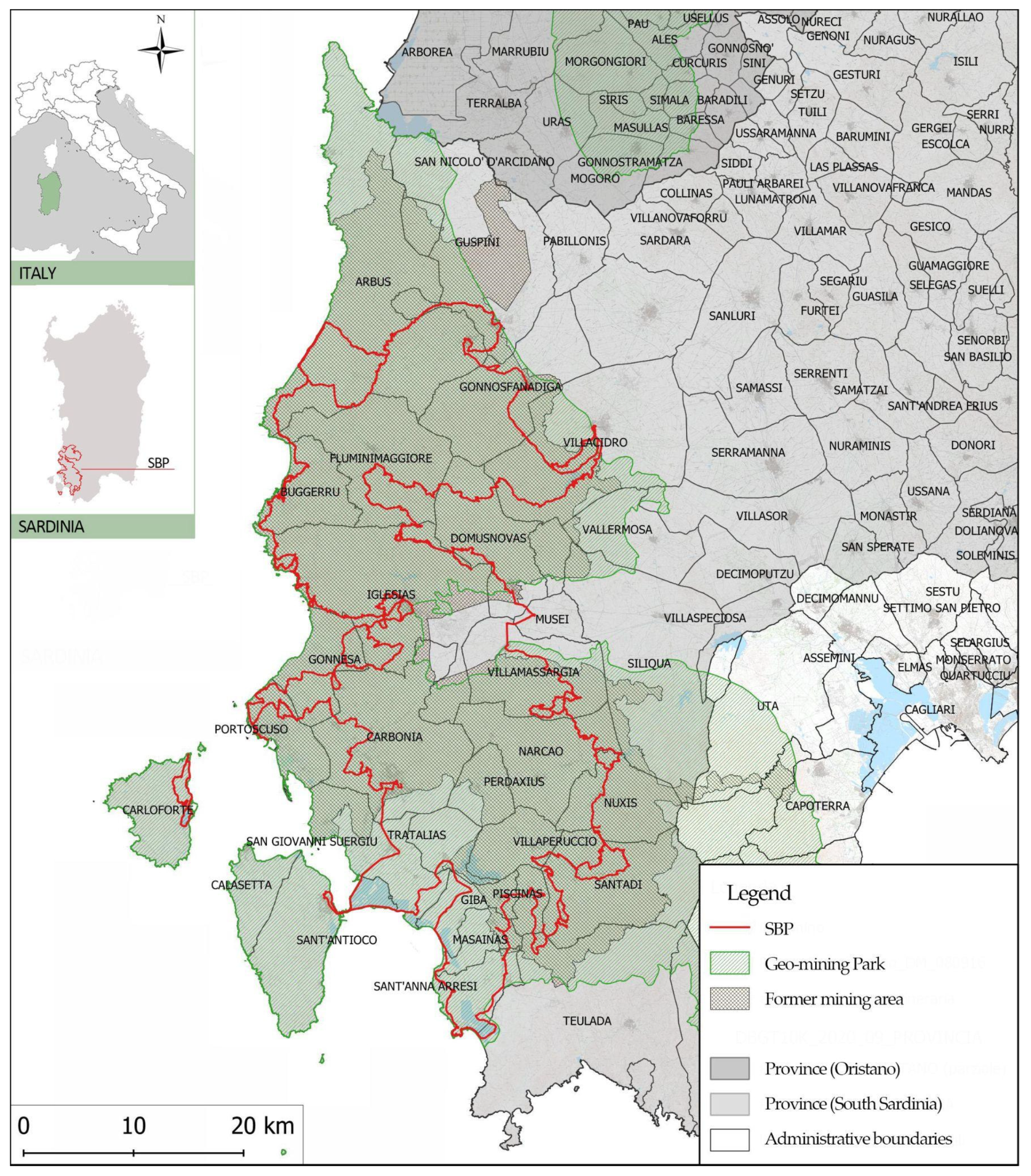
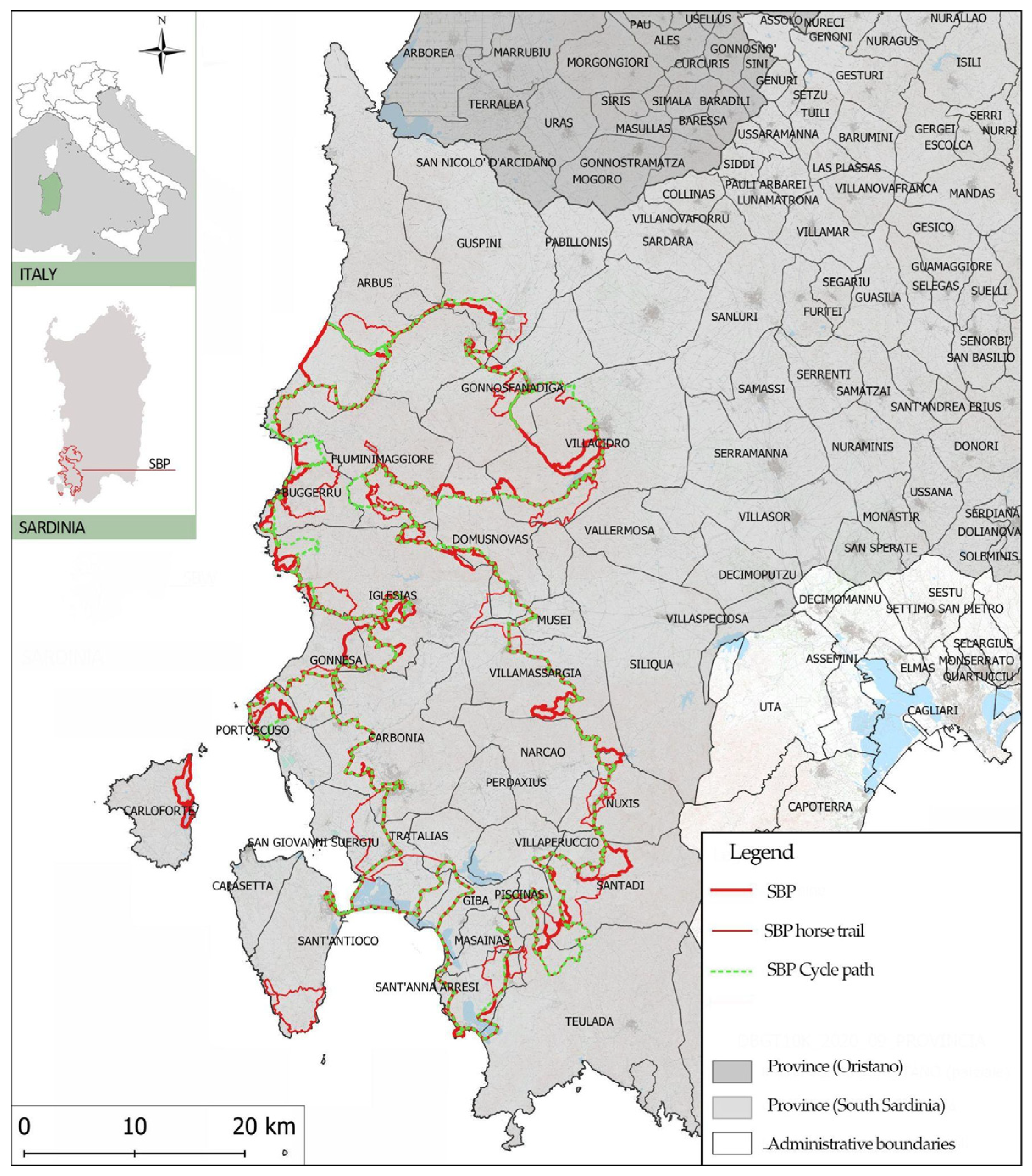
2.1. Study Area—The Santa Barbara Path and Horse Trail Proposal Network

The Santa Barbara Path (SBP) is an itinerary drawn in the Sulcis-Iglesiente area, in south-western Sardinia, an historical region that was the most important district for national and international mining until the 1990s, when the crisis hit the sector, causing the mines’ dismantling [58]. As a consequence, the mining landscape is marked by large open-air and underground works, mine adits, tunnels, and numerous mine wastes.
The principal result of this extensive mining activity is the economic depression that required the rethinking of a new development, also through forms of sustainable tourism [59] capable of enhancing the great heritage of industrial archeology [60] in a particularly beautiful mining and coastal landscape [61].
The SBP, which extends along a 500 km ring, organized into 30 tracks, follows the traces drawn by mining activities in the past decades in a unique landscape in transition—or landscape in progress—understood as the outcome of different stages of human–nature interaction [62]. In this sense, the SBP represents a response to the demand for a particular type of rural and slow tourism [63] associated with the use of GIs, which, in the Sulcis-Iglesiente region (mining bioregion), arises as a driving force for economic development.
Over the last few years, the SBP has been included in the regional register of historical-religious walks of Sardinia and in the Atlas walk of Italy of the Ministry of Cultural Heritage and Activities.
In line with the objectives of the Geo-Mining Park, the SBPF constantly promotes different types of accessibility as a primary condition for a new development phase based on the concept of rural and slow tourism [64], according to principles that guide the political strategies of the regional level [65]. As a matter of fact, the construction of a horse trail, connected to the SBP and to the cycle path (a thematic route connected to the great cycling network of Sardinia) [66], represents one of the most important projects carried out by the SBPF (Figure 2). The horse trail consists of a ring route of over 500 km, divided into 18 tracks and 19 Stop Points (SP), which crosses 24 municipalities.
In this sense, the SBPF intends to enhance the SBP as a GI for rural and slow tourism for several integrated aspects: the recovery of the old mining tracks; provision of a different travel way (walk, bike, and by horse); and the offer of a widespread and low-cost hospitality system, which integrates the existing one. If the project of the tracks is in progress, that of the Stop Places (SP) represents an important challenge.
Following previous research [67,68], we propose a methodological approach to develop an index (FI—feasibility index) to assess the feasibility of the Stop Places (SPs) scheme along a horse trail to integrate current slow mobility methods (walking and biking), referring not so much to the stages, for which the project is already in progress, as to the SPs, understood as the main nodes of a network of routes (walk, bike, horse) to support slow integrated mobility.

2.2. Planning Horse Trails: Principles and Approaches

The geographical Italian context hosts several horse trails, which differ in various aspects: characteristics of the areas crossed—mountainous, hilly, plain, coastal territory; localization—they may fall within protected natural areas [69,70], along the rivers [71] and, in some cases, follow historic roads and ancient transhumance routes [72] or old railways [73]; length (km); number of tracks; provision of facilities and services along the route to support the riders and the equids themselves; and connection with other existing slow mobility networks [74], such as cycle paths and walks [75]. One of the most important is the horse trail in the Gran Sasso and Monti della Laga National Park (Ippovia Gran Sasso—Abruzzo Region) [76], which represents the longest horse trail in Europe (520 km). It crosses 36 municipalities, following the paths which, for centuries, have connected villages and towns separated by the Gran Sasso, a massif in the Apennine Mountains of Italy, which have always been used by farmers. Other notable horse trails in Italy are those that cross regional and national parks, such as the Appia Antica Regional Park (Lazio Region), the Maremma Natural Park (Tuscany Region), the Majella National Park (Abruzzo Region), and the Alta Langa Park (Piedmont Region). As a matter of fact, recent research confirms the importance of nature in the expectations of horse trail ride tourists [77].
The horse trails’ planning and management requires the observation of several criteria to ensure the safety and well-being of horseback riders and horses [78,79], according to the environmental context [80]. The main aspects to be considered concern [81]:
  • Surface, which should be well-drained, firm, and free of sharp stones or other hazards that could cause injury to a horse’s hooves;
  • Dimension, which should be wide enough for horses to pass each other safely and free of obstacles that could be dangerous for horses and riders;
  • Grade, which should be moderate, with no steep inclines or declines that could be difficult for horses to navigate;
  • Signage, which should be clear and include information about trail difficulty, distance, and any potential hazards;
  • Maintenance, which should be ensured regularly;
  • Equestrian facilities, which should include areas for horse camping, loading and unloading horses, and parking for horse trailers.
Some important references for the horse trail planning in Italy are (Figure 3):
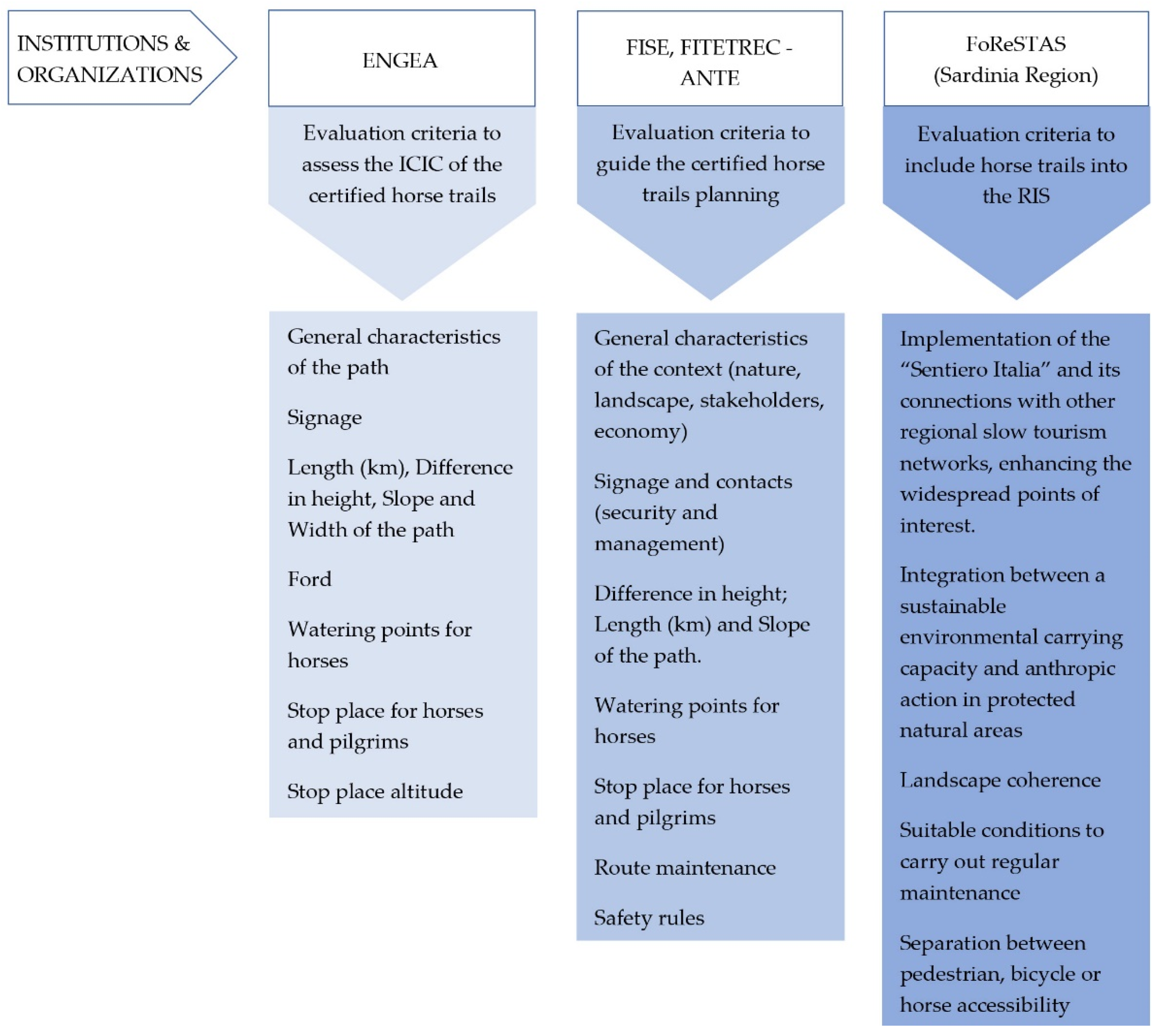
  • The National Board of Environmental Equestrian Guide (ENGEA—Ente Nazionale Guide Equestri Ambientali) guide for obtaining certification. The Certified Horse Trail Classification Index (ICIC—Indice di Classificazione Ippovie Certificate) reflects the degree of difficulty of each horse trail [82];
  • The specification for the design of Italian horse trails drawn up by Italian Equestrian Sports Federation (FISE—Federazione Italiana Sport Equestri) [83];
  • The specification for the design of Italian horse trails certified by the Italiana Equestrian Tourism Federation and Trec-Ante (FITETREC-ANTE—Federazione Italiana Turismo Equestre e Trec—Ante) [84].
This topic is particularly important in Sardinia, where the rural landscape constitutes the connective structure of the wider scenario of the regional landscapes [85], which has long been at the core of territorial development policies.
The Sardinia Region, with Regional Law No. 16/2017 [86] recognizes the use of equines (horses and donkeys) for enhancing the tourist and environmental heritage of Sardinia. This is possible through specific interventions aimed at the creation of a network of horse trails and the functional recovery of facilities for logistical, resting, and support needs of riders and animals. Specifically, Article 28 of the Law defines technical criteria regarding the Network of Hiking, Bicycle Hiking, and Horse Trails. The Sardinian Horse Trails Network (RIS—Rete delle Ippovie della Sardegna) represents a subset of the paths of the Sardinian Hiking Network (RES—Rete Escursionistica della Sardegna) for which the walkability on horseback is validated. The measure also establishes a special regional register of Sardinia’s horse trails. The updating of this register is regulated by the Plan for the Establishment and Management of the Sardinian Hiking Network (RES), under the coordination of the Regional Forestry Agency for Land development and environment of Sardinia (FoReSTAS—Agenzia forestale Regionale per lo Sviluppo del Territorio e l’Ambiente della Sardegna).
Indeed, horse trails find wide application in Sardinia because there is a long tradition of horse farming and some types are particularly suitable for trekking [87].
According to FISE and FITETREC-ANTEA, the SPs along the horse trail are defined as the system of facilities that provide hospitality for riders and/or shelter for horses in boxes, stalls, pens, suitably equipped with water and hay, which guarantee their safety and well-being.
In addition, ENGEA identifies the following types of accommodation facilities (farmhouses, hostels, guesthouses, refuges, hotels, or clubs), and the minimum characteristics of each one. This leads to the definition of four main types of SPs, which combine different services to support riders and horses.
The first ENGEA certification in Italy was awarded in 1998 to the horse trail named “On the Griffon’s Route” in Sardinia. The “Magical Cala Luna Beach” horse trail is also included, to date [88]. The first one is 130 km long and runs from the city of Alghero to the Sale Porcus Oasi in the Sinis peninsula (Province of Oristano), crossing one of the most internal stretches of the west coast, which is highly interesting for its landscape. The horse trail, which is an average difficulty, thanks also to its modest elevation gain ranging from 0 to 780 m asl, can be covered in 7 days. The second one, with a length of 136 km, crosses a complex territory, from the internal areas of the Barbagia (Supramonte mountains of Orgosolo, Baunei, and Urzulei) to the east coast (beach of Cala Luna) recording a difference in altitude ranging from 0 to 1200 m asl. The horse trail, of medium-high difficulty, can be hiked in 3 or 5 days.
At the regional level, one of the most ambitious projects concerns the “Costa-a-Costa” horse trail [89], which crosses central Sardinia from the east coast to the west coast. This path mostly retraces old mule tracks and itineraries existing between beaches, Mediterranean scrub, wilderness, and internal prairie. Each SP ends with the stabling of horses and the welcoming of riders. The horse trail, about 135 km long, is divided into six tracks.
The regional level horse trail system is also expanding thanks to the interventions financed by the Sardinia Region to increase the RES and RIS [90].
The proposal for a new SBP horse trail in the historic Sulcis-Iglesiente region is part of this renewed awareness on the opportunity of horse tourism, in addition to walking and biking.

3. Methodology

Moving in the research field focused on the accessibility of mining heritage and geosites [13,91], this study proposes a methodological approach to develop a feasibility index (FI) to assess the feasibility of the Stop Places (SPs) project scenarios of the horse trail, in terms of Internal Coherence (IC) criteria and External Coherence (EC) criteria, to integrate slow mobility methods (walking and biking).
In line with the methodological approach adopted in recent studies to define the complex index for supporting urban policies and planning [73] and developed by the authors themself in previous research [64], to define a set of indicators to assess the attractivity index of the SBP tracks, the methodology consists of three quali-quantitative phases (Figure 4):
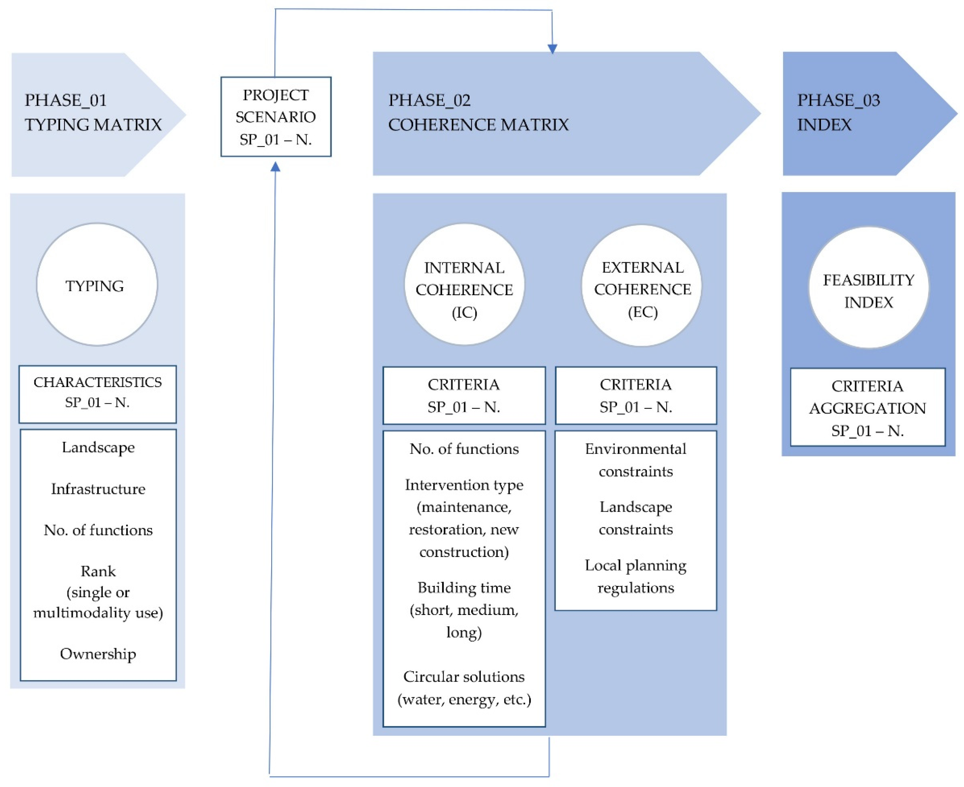
  • Phase_01—which develops a typing matrix according to a set of typing elements selected by the literature review and practices analyzed. The typing matrix allows each SP to be analyzed according to landscape, infrastructure, number of functions, rank, and ownership characteristics, from which specific project scenarios are derived (output);
  • Phase_02—which defines a coherence matrix according to a set of Internal Coherence (IC) criteria and External Coherence (EC) criteria for each SP’s project scenario. The IC criteria, which refer to the intrinsic characteristics specific to each SP project scenario, are: the number and variety of functions, the intervention types planned (maintenance, restoration, new construction), the building time required (short, medium, long), and the circular solutions (water, energy, etc.) adopted. The main EC criteria, which refer to the external factors specific to the SP context, are the environmental and landscape constraints and the local planning regulations in force;
  • Phase_03—which defines the feasibility index (FI) of SP’s project scenarios through a quantitative criteria aggregation.
The methodology provides feedback between the Phase_02 and the project scenarios (output). As a matter of fact, a possible lack of coherence with the IC and EC criteria, such as the incompatibility with the regulatory framework, may require the need to redefine the project scenario.
In line with previous research which proposed guidelines and protocols for the design of touristic paths, according to the combined use of ecological and historical approaches [92], as well as other complex models to manage the anthropic pressure in protected environmental areas [93], in this study, the IC and EC criteria meet the objectives at the core of various case studies examined (Section 2.2), primarily that of the SBPF, which are in line with the 2030 Agenda Sustainable Development Goals (SDGs). They may be summarized as follows:
  • The sustainable planning of horse trails, as well as that of paths (walking and biking) to support the regeneration of former mining landscapes and deprived internal areas, in order to guide a new course of development based on rural and slow tourism (Goal 3; Goal 8; Goal 9; Goal 13; Goal 15; Goal 17);
  • The reuse of the existing buildings (mainly heritage of industrial archaeology, properties of abandoned mining villages) to ensure a network of accommodation facilities for the well-being of pilgrims (walking, biking and horse riding) and horses (boxes, paddocks, and support services), in order to realize the SPs during the short to medium term, thus reducing the time for the commissioning of the horse trail (Goal 11; Goal 12; Goal 13; Goal 15; Goal 17);
  • The compliance of the SP’s project scenarios with the multifunctionality and circularity criteria, through the redevelopment of existing buildings aimed at achieving water and energy self-sufficiency, and the realization of equipped areas for horses stabling, with primary services (water and energy self-sufficiency, water recovery, and waste recycling). Such conditions are key prerequisites for ensuring environmental and economic sustainability even in the subsequent phase of use and management of the horse trail and its SPs (Goal 6; Goal 7; Goal 11; Goal 12; Goal 13; Goal 15).

3.1. Feasibility Index—FI
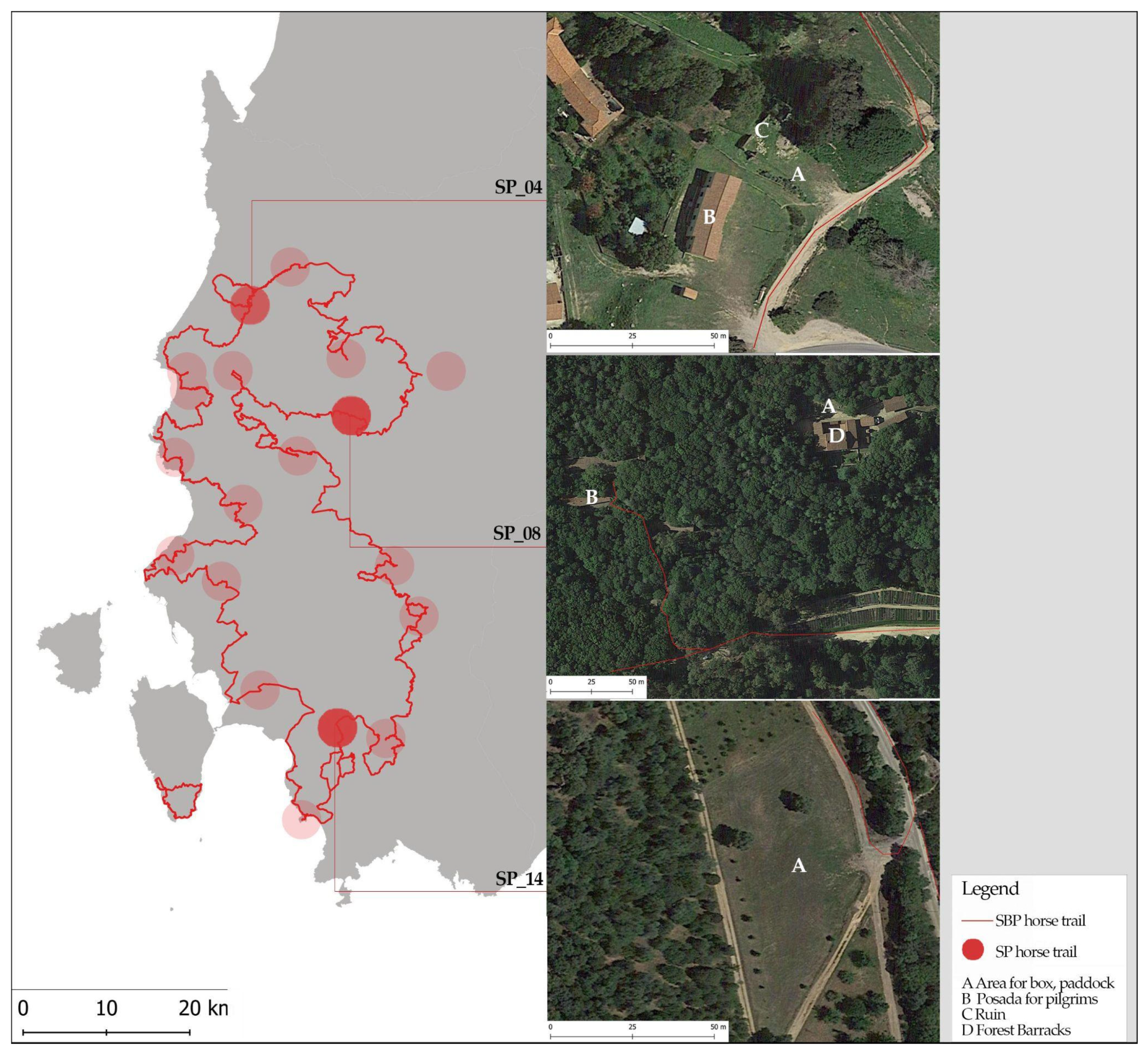
The Phase_03 is dedicated to the definition of the FI, edited by the authors and in line with the literature on the construction of complex indices [94] of the SP project scenarios through assigning specific weight to the criteria of IC and EC. In particular, the FI can be defined as a half of the sum of the weighted sum (pi and pe) of the IC and EC, as below.
The proposal of the quantitative index (FI) relating to a SP scenario project is closely linked to the coherence IC and EC, which constitute the main feasibility assumptions.
FI = 1 2 i = 1 n p i × IC i = 1 n IC i + e = 1 n p e × EC e = 1 n EC e
where i = 1, 2, 3, … n; e = 1, 2, 3, … n, where 0 ≤ pi ≤ 1, 0 ≤ pe ≤ 1, 0 ≤ FI ≤ 1.
The weight assignment to each criteria (IC and EC) have the following characteristics: pi and pe tend to 1 when the SP project scenario meets full IC and EC.
In particular, if FI = 0–0.25, it represents a critical scenario (Level 4); if FI = 0.26–0.50, it represents an average critical scenario (Level 3); if FI = 0.51–0.75, it represents an average positive scenario (Level 2); if FI = 0.76–1, it represents a positive scenario (Level 1).

4. Case Study

The above methodology was applied to three SPs of the horse trail of SBP, which have been selected by virtue of their geographical, landscape, physical, and functional characteristics. Moreover, the public or private nature of the SPs is of importance because the ownership significantly affects the implementation of the projects. The SPs falling in private areas are already configured, in most cases, as existing stables or riding clubs. On the contrary, the SPs falling in public areas are places where the design is required, especially with regard to the structures for the well-being of equids (horse-box, paddocks, and other services), for which the feasibility study is necessary. For this reason, the case studies selected to apply the methodology refer only to those SPs located on publicly owned areas.
The case studies fall in three different municipalities in the South Sardinia Province, within the perimeter of the Geo-Mining Park DM 08/09/2016 (Figure 5):
  • SP_04 “Posada Pitzinurri”, municipality of Arbus;
  • SP_08 “Monti Mannu”, municipality of Villacidro;
  • SP_14 “Parco is Muras”, municipality of Giba.
A more detailed description is presented below:
SP_04 “Posada Pitzinurri” falls in the former mining village of Pitzinurri, in the Ingurtosu area, in the Municipality of Arbus. Located in the SP is a building acquired thanks to the agreement signed between the SBPF and the Municipality of Arbus, already used as accommodation for SBP users and, therefore, for the overnight stay of riders of the future horse trail. Along the SBW, accommodation facilities for the well-being of pilgrims (walking, biking, and horse riding) are called ‘Posadas’ (small accommodation). Adjacent to this facility, which is named “Posada di Pitzinurri”, there is an area containing stone structures, in a ruined state. These are the remains of ancient mining buildings. These structures can be found on the left bank of a small river called “Riu de Naracauli” that flows into the artificial lake of Pitzinurri. Measures to restore the structures, combined with those to excavate and consolidate the bank, would provide space for horse stalls.
However, SP_08 “Monti Mannu” falls within the Monti Mannu Forest, which is a naturalistic, environmental forest complex of Monti Mannu-Oridda-Marganai, in the municipality of Villacidro. In the SP, which is larger than the previous one, there is the old “Locanda del Parco”, a building that since 2018 has been acquired by the SBPF. The locanda has been designated as accommodation (Posada) for SBP users and overnight stays for riders of the future horse trail after the restructuring works. Approximately 120 m away from this structure, which is named “Posada di Monti Mannu”, is the forest compendium consisting of a main building (forest barracks) and its outbuildings. In addition, there is a partially equipped area for equids to rest.
The SP_14 “Parco is Muras” lies in an area earmarked for Municipal Park parking lots (“Parco is Muras”), in the municipality of Giba. In a partnership with the Municipal Administration, a portion of the area, where the terrain is likely to be flat, will be used to accommodate equids that will ride the SBW horse trail. Compared to the SPs previously considered, no accommodations for pilgrims insist on SP_14, and also no buildings to be redeveloped or rehabilitated.
The application of the three phases of the methodology described above is shown below. Specifically, Table 1 and Table 2 report the typing matrix (Phase_01) and project scenarios, and the Internal Coherence (IC) and External Coherence (EC) matrix (Phase_02), respectively, related to the following SPs: SP_04, SP_08, SP_14.
For Phase_01, the main data source for typing the three SPs are the Sardinia Region website [95], the SBPF, the Cadastre website, and the authors themself, who produced data through desk analysis and on-site surveys.
The desk analysis refers to the collection and systematization of data from the following institutional sources:
  • The SBPF, which represents the main source of information relating to the SBP horse trail project;
  • The Cadastre website, which allows the public to know the public or private nature of those areas selected by the SBPF to develop the SP project scenarios;
  • The Geoportal of the Sardinia Region, which represents the main source of data relating to the environmental and landscape characteristics of the place (regulatory framework affecting the areas);
  • The official website of the Local Administrations involved in the SBPF horse trail project, which represents the main source of the urban planning tool in force.
The on-site survey in those areas selected by the SBPF to implement the SPs has been fundamental to technically analyze the physical, landscape, and environmental characteristics of the site and provide guidelines for the SPs project scenario.
The project scenarios (output) proposed are the result of the joint work carried out by the SBPF and the authors themself (Table 1).
For Phase_01 (Table 1), it can be seen that the typification of the three SPs allows for the development of specific project scenarios (output). In the SPs in which no buildings to be redeveloped or rehabilitated exist, the project scenario coincides with the construction of equipped areas for boxes and paddocks; in the SPs where there is a building stock already used for housing or to be redeveloped or recovered for accommodation or other services, the project scenario contemplates the construction of facilities for animal welfare (boxes, paddocks, and support services), facilities for the well-being of pilgrims (walking, biking, and horse riding), and other services to support the users of the horse trail in addition to the ones mentioned above.
For Phase_02 (Table 2), the data source corresponds to the SBPF and the authors themself, who implemented a set of criteria for the IC and EC matrix.
It is important to underline that the intervention types (IC criteria) are those defined in Italy by the Presidential Decree 380/2001 (Art.3; Art. 6) and subsequent additions:
  • Ordinary maintenance (MO—Manutenzione Ordinaria), extraordinary maintenance (MS—Manutenzione Straordinaria), building renovation (RE—Ristrutturazione Edilizia) of existing buildings;
  • Restoration (R—Restauro) and conservative rehabilitation (RC—Risanamento conservativo) for the recovery of the ruins;
  • New Construction (NC);
  • Free building activities for the construction of horse-box, paddocks, and other services (EL-Edilizia Libera).
The regulatory framework indicated to assess the EC of each SP consists of:
  • Environmental constraints, relating to the presence of protected natural areas (oases, regional or national natural parks, Natura 2000 Network sites) and areas managed by the FoReSTAS agency;
  • Hydrogeological constraints;
  • Landscape constraints, which refer to a comprehensive regulatory framework, at regional and national level, as the Italian Code on cultural heritage and landscape (Law enacted by decree no. 2004/42) and the Regional Landscape Plan (PPR—Piano Paesaggistico Regionale);
  • Local plan in force (land use regulation referred to areas interested by the SP).
The assessment of the feasibility index (FI) (Phase_03) requires the determination of specific weights for each Internal Coherence (IC) and External Coherence (EC) criteria, consistent with the SBPF goals (Table 3).
The Internal Coherence (IC) criteria and their weights (pi) can be summarized as follows:
Nf = number of expected functions in each SP (animal welfare facilities, pilgrim accommodation facilities, equipped areas, other services);
if Nf ⇒ n the weight pi(Nf) ⇒ 1, consistent with the goal of providing the greatest number and variety of services and functions at the horse trail SPs: pilgrim well-being facilities (walking, biking, horse riding), animal welfare facilities (box, paddock) and other services.
Nm = number of months required for the planned intervention in each SP, to be carried out in the short, medium, or long term, through the following typologies: ordinary and extraordinary maintenance (MO, MS, RE, R, RC) of public housing heritage to ensure accommodations and services for pilgrims and places for horses; free building activities for the construction of facilities for animals (EL);
if Nm ⇒ 0 the weight pi(Nm) ⇒ 1, consistent with the need to bring the horse trail up to speed as soon as possible.
Nc = the number of circularity requirements of the SP project (water, energy, organic material waste, etc.);
if Nc ⇒ n the weight pi(Nc) ⇒ 1, consistent with the goal of ensuring primary services according to the circular economy principle (water and energy self-sufficiency), water and waste recycling, and soil permeability.
The External Coherence (EC) criteria and their weight (pe) referring to landscaper constraints, and zoning regulations can be summarized below:
Nce = number of external coherences
if Nce ⇒ 3 the weight pe(Nce) ⇒ 1; thus, the SP project is consistent with landscape constraints and urban planning discipline.

5. Results

The application of the method for assessing the FI to the three selected SPs (SP_04, SP_08, SP_14) gives rise to the following results (Table 4, Table 5 and Table 6).
The SP_08 achieves the highest FI value of 0.93, followed by the SP_14, with an FI of 0.91. SP_04 records the lowest value, with an FI of 0.57. More precisely, FI = 0.93 and FI = 0.91 correspond to a positive scenario (Level 1). At the same time, FI = 0.57 corresponds to an average positive scenario (Level 2).
Contributing to the highest value of FI for SP_08 were: the high number and variety of functions (3); the short time required for the redevelopment and change facilities use, estimated at 4 months; the high number of circularity feature criteria met by the project (4); and the level of EC, highest (3). The SP_14 project scenario, while also having the highest degree of EC (3), as it is consistent with landscape constraints and urban planning discipline, has a slightly lower FI value than SP_08 because it suffers from the absence of an existing building stock capable of accommodating pilgrim well-being services and other functions to support the horse trail. In fact, the only function contemplated by the SP_14 project scenario is the equipped area for the establishment of boxes and paddocks.
Finally, the lower value of FI of SP_04 is mainly determined by two factors: as far as IC is concerned, the number of months required to carry out the restoration work on the structure in the state of ruins, near the Posada, and which could house horse boxes; as far as EC is concerned, the lack of coherence with urban planning regulations.
The scenario presented, which emerged from the proposed method to assess the FI of the SPs along the SBP, highlighted the opportunities that can be generated by the functional reuse of existing buildings, mainly in terms of the number and variety of services offered for the well-being of pilgrims and horses. The redevelopment of the existing buildings according to circularity criteria also has a strong influence in determining the IC of the scenarios, as well as the timing for the realization of the interventions. On the other hand, the lowest FI derived by a limited EC highlights how much coherence with the superordinate constraints and with the urban planning discipline affects the determining of the feasibility of the projects.
In light of these results, specific strategies are required to overcome the average positive scenario and, as a consequence, to increase the level of feasibility of the SBW horse trail project. First of all, the SBPF may prioritize the implementation of the SPs project scenarios that record the highest FI, thus reducing the time for the commissioning of the horse trail. Moreover, with reference to SPs project scenarios that record a low FI, if the determining factor is the low number and variety of functions, the SBPF could implement the horse trail planning strategies involving nearby nodes and centralities along the path. At the same time, if the determining factor is the low degree of coherence with existing urban planning regulations, the SBPF may promote concertation processes with the local authorities directly involved.

6. Discussion

Beginning with the analysis of the literature on safety and well-being criteria for riders and horses in the planning and management of horse trails [78,79], and with due respect for the environmental values that characterize the different territorial context [80], this study aimed to define typing and Internal and External Coherence matrices to assess the feasibility of SP project scenarios to be implemented, taking into consideration multiple aspects.
As compared to the literature reviewed in Section 2.2, concerning horse trails planning [82,83,84,86] and the horse and rider rest well-being facilities design [78,79], this study introduces a set of Internal and External Coherence (IC and EC) criteria to evaluate the SP project scenarios. In particular, the IC criteria derive from a set of Italian directives and guidelines, and previous research focused on the main fields of investigation of this study, which have been appropriately analyzed and organized to develop the FI:
  • Italian directives and guidelines related to the protection and management of equids, issued by the Ministry of Health (Ministero della salute) [96,97,98];
  • Principles and criteria for the horse trail planning/design, resulting from existing horse trails or proposed schemes [71,73,76,81];
  • Principles and criteria for the horse trail planning/design, clarified in reports issued by institutions and organizations in Italy, at a national and regional level [82,83,84,87,90];
  • Principles and criteria for horse services and other facilities design (box and paddock) [78,79,99,100].
The EC criteria derive from the analysis of the literature concerning the management and impact assessment of horse trails in protected areas [69,70,77,80,93], and, above all, from the systematization of the environmental and landscape constraints and of the land use according to the local plans in force in the SPs.
Guided by the approaches of Bambi et al. [78], who have planned two different solutions of structures for the horses observing the principles of low impact, low cost, easy installation, and complete reuse, additional Internal Coherence criteria were identified: the number and variety of functions, possible interventions, construction time, and circular solutions in both buildings and stalls, including stormwater recovery and self-production of energy.
The criteria were combined through an analytical approach, where specific weights were assigned to each IC and EC consistent with the goals of the promoting organization (in this case, the SBPF), inspired by those of the 2030 Agenda, and the challenges imposed by the ecological transition.
However, this was possible mainly because, as described in Section 2.1, the SBP horse trail project is a work in progress, particularly with regard to SPs. This condition is a prerequisite for the development of methodology. The promoting organization’s (SBPF) principles, goals, and priorities are the ones that guide the assignment of a specific weight to each identified criterion. Thus, the importance given to multifunctionality, to the reuse of existing building stock, to the short-to-medium time of implementations of interventions, and to circular solutions in defining the SP scenario have had a decisive impact on the calculation of the IF. This takes a sort of priority score considering the objectives of the main stakeholders [73]. The assigning to EC criteria weights, that is, to the constraining framework and urban planning regulations insisting on the SP areas, seems to appear less impactful in directing policies, precisely because these are established and difficult to change.
The decision to propose an FI to assess the feasibility of SPs, intended as the main integrated nodes of a path network (walking, biking, horse riding) to support horse mobility, highlights how the study makes a scientific contribution with reference to a more circumscribed, but still complementary, dimension of the research field investigating the accessibility of mining heritage and geosites [13,91].
The importance attached to the reuse of existing physical structures [73], including the ancient tracks related to the miners’ landscape, are common elements of the main approaches analyzed. These elements add to the necessary and prioritized action of systemic ecological restoration, but also to the recognition of nodes in the complex spatial matrix design of accessible places [13].
Hence, the SPs along the horse trail can also be considered nodes integrating with the other core sites of different value, function, and rank. In this context, the Sulcis-Iglesiente’s complex and wide bioregion, which is characterized by a significant tie between GIs and mining heritage, is suitable to host the most recent trends of rural and slow tourism, also combining the fruition of resources toward sports activities [101]. The SBW horse trail as a whole (tracks and SPs), like other slow mobility planning perspectives in Italy and beyond [71], may strengthen the spine of a network of ecological services and existing public facilities, enhancing the relations with the small/medium urban centers it goes through according to the specific characters and lifestyles of these contexts.

7. Conclusions and Future Developments

The cohesive goal included in the territorial planning of countries at an international level has stimulated the creation of different methodologies for ‘structuring areas’ that should be safeguarded and managed in a sustainable and multifunctional perspective. This study examined the issue related to the slow use of the mining landscape (also in terms of tourism), identifying the creation of a bioregion and the adoption of green infrastructures as useful strategies for re-territorializing rural areas in a particularly sensitive area characterized by a landscape in transition that is a result of ceased mining activity. Furthermore, these initiatives at various levels have contributed to strengthening the current network of protected areas and other effective conservation measures.
In particular, the first section was dedicated to the literature review concerning three main topics which, although represent well-defined research fields, have been investigated according to an integrated approach. We considered the integration of the concept of rural and slow tourism, green infrastructure (GI), and bioregion fundamental to achieve the main purpose of the paper. Such a preliminary phase represented a starting point for developing the following sections.
The second section was dedicated to the analysis of the study area, the Sulcis-Iglesiente-Guspinese bioregion, in the south-western part of the Region of Sardinia, which has already been the subject of previous analyses and field research carried out by the working group. Moreover, the area studied has long been the subject of strategies and policies for territorial valorization at different scales. In addition to the institution of the Geo-Mining Park, other examples are the creation of the Santa Barbara Path Foundation (SBPF), and the establishment of the Santa Barbara Path (SBP) and the local network. These initiatives enabled a regenerative process of the places in environmental, social, and economic terms. Subsequently, the SBPF launched a project aimed at enhancing the existing path (for walking and biking and, more recently, horse riding). The horse trail is an itinerary that only partially coincides with the SBP, which is alternated by SPs that serve as equipped stopping nodes.
The third section proposed a methodological approach to develop a feasibility index (FI) to assess the feasibility of the Stop Places (SPs) project scenarios along a horse trail. The FI derives from the result of typing matrices and coherence matrices for each SP project scenario, implemented in the fourth section of the paper, where three SPs were selected as the case study to assess the methodology.
From the policy maker’s point of view, the FI is useful in providing support for planning future actions in a hierarchical way, considering the stakeholder’s objectives and the first ambition to carry on the horse trail project as part of a more general perspective aimed at integrating the SBP (walking, biking, horse riding) with the Green Infrastructure network, to reap the benefits of adopting multifunctional strategies based on ecosystem services within the related bioregion. In this sense, the future line of research should take into account the effects of re-territorialization related to diluting rural identity, diminishing place distinctiveness, and depleting the cultural and economic sustainability.
Such initial setup of the FI is a basis for future research and applications.
The future developments of this study will cover the assessment of the FI for all the SPs along the SBP horse trail, in order to guide the whole planning process in an integrated way. The application of the methodology may require the need to modify the set of indicators underlying the definition of the FI. As a matter of fact, the FI assessment here suggested should be implemented in line with the goals, priorities, and criteria to be pursued and observed in a particular context, such as that of the Sulcis-Iglesiente bioregion, characterized by a significant mining heritage.
As a matter of fact, the main challenge of this research work lies in the effective collaboration between public bodies involved in the SBP horse trail planning, as well as other local operators interested in investing not only in the tourism sector, but also in taking advantage of the multifunctionality of the context. Furthermore, it is important to underline that the success of the SBP horse trail will also depend on the smart community activities, which, by disseminating and sharing information, promote the SBP and its multi-accessibility (walking, biking, horse riding). In this sense, among the External Coherence criteria (EC) selected for the definition of the FI, the pedestrians’, bikers’, and, above all, riders’ perceived accessibility could also be considered and implemented in the future [102].
In conclusion, it is believed that the methodology proposed can represent a reference framework applicable to other territorial contexts to achieve the European policy’s goals for the medium- and long-term landscape conservation and valorization.

Author Contributions

Conceptualization, M.L. and G.B.; methodology, M.L. and G.B.; validation, all authors; formal analysis, G.B.; investigation, M.L.; resources, all authors; data curation, M.L.; writing—original draft preparation, all authors; writing—review and editing, M.L., G.B. and S.B.; supervision, G.B. In particular, Section 1, Section 2.1 and Section 3.1 were written by G.B.; Section 1.1 was written by S.B.; Section 1.2, was written by A.A.G.; Section 2.2, Section 3, Section 4, and Section 6 were written by M.L.; Section 5 was written by M.L. and G.B.; Section 7 was written by M.L. and A.A.G. All authors have read and agreed to the published version of the manuscript.

Funding

Part of the research activity presented in this paper by authors G.B. and M.L. was funded by the “Santa Barbara Path Foundation” and implemented at the Department of Civil and Environmental Engineering and Architecture (DICAAR) of the University of Cagliari, Italy (05/2022-2023).

Institutional Review Board Statement

Not applicable.

Informed Consent Statement

Not applicable.

Data Availability Statement

Data used in the research can be obtained on request to the corresponding author.

Acknowledgments

Part of the research activity presented in this paper by authors G.B. and M.L. was developed within the following project: ‘Landscape planning approaches for slow tourism. New scenarios for the Santa Barbara Walk’, funded by the “Santa Barbara Path Foundation” and implemented at the Department of Civil and Environmental Engineering and Architecture (DICAAR) of the University of Cagliari, Italy (05/2022-2023).

Conflicts of Interest

The authors declare no conflict of interest.

Glossary

ECExternal Coherence
ENGEAEnte Nazionale Guide Equestri Ambientali (Board of Environmental Equestrian Guide)
FIFeasibility index
FISEFederazione Italiana Sport Equestri (Italian Equestrian Sports Federa-tion)
FITETREC-ANTEFederazione Italiana Turismo Equestre e Trec—Ante (Italian Eques-trian Tourism Federa-tion and Trec-Ante)
FoReSTASAgenzia forestale Regionale per lo Sviluppo del Territorio e l’Ambiente della Sardegna (Regional Forestry Agency for Land development and environment of Sardinia).
GIGreen infrastructure
ICExternal Coherence
ICICIndice di Classificazione Ippovie Certificate (Certified Horse Trail Classification Index)
RESRete Escursionistica della Sardegna (Sardinian Hiking Network)
RISRete delle Ippovie della Sardegna (Sardinian Horse Trails Network)
SBPSanta Barbara Path
SBPFSanta Barbara Path Foundation
SPStop Place

References

  1. UNWTO—World Tourism Organization. UNWTO Tourism Definitions; UNWTO: Madrid, Spain, 2019. [Google Scholar]
  2. Lumsdon, L.; McGrath, P. Developing a conceptual framework for slow travel: A grounded theory approach. J. Sustain. Dev. 2011, 3, 265–279. [Google Scholar] [CrossRef]
  3. Privitera, D. Turismo lento e territori insulari. Il caso studio Favignana. Boll. Della Assoc. Ital. Di Cartogr. 2020, 169, 145–153. [Google Scholar]
  4. Colavitti, A.M.; Floris, A.; Serra, S. Urban standards and ecosystem services: The evolution of the services planning in Italy from theory to practice. Sustainability 2020, 12, 2434. [Google Scholar] [CrossRef] [Green Version]
  5. EC. Commission Staff Working Document. Technical Information on Green Infrastructure (GI) SWD (2013) 155 Final 6 May, Brussels. 2013. Available online: https://ec.europa.eu/environment/nature/ecosystems/docs/green_infrastructures/1_EN_ACT_part1_v5.pdf (accessed on 1 February 2023).
  6. European Union. 2019. Available online: https://eur-lex.europa.eu/legal-content/IT/TXT/PDF/?uri=CELEX:52019DC0236&qid=1562053537296 (accessed on 25 March 2020).
  7. Lai, S.; Leone, F.; Zoppi, C. Green infrastructure and protected areas: A study concerning Sardinia. In Building the Urban Bioregion. Governance Scenarios for Urban and Territorial Planning; Colavitti, A.M., Serra, S., Eds.; SdT Edizioni: Firenze, Italy, 2022; pp. 373–392. [Google Scholar]
  8. Lai, S.; Leone, F.; Zoppi, C.; Isola, F. An Operational Framework. In Green Infrastructure and Regional Planning; Franco Angeli: Milano, Italy, 2022; pp. 1–186. [Google Scholar]
  9. Romano, F.; La Rocca, R.A. Slow Mobility and Cultural Tourism. Walking on Historical Paths. In Smart Planning: Sustainability and Mobility in the Age of Change; Springer: Berlin/Heidelberg Germany, 2018; pp. 301–322. [Google Scholar]
  10. Tomi’c, S.; Lekovi´c, K.; Stoiljkovi´c, A. Impact of motives on outcomes of the travel: Slow tourism concept. Školabiznisa 2018, 2, 68–82. [Google Scholar]
  11. Agarwal, S.; Busby, G.; Huang, R. Slow tourism. In Special Interest Tourism: Concepts, Contexts and Cases; CABI: Wallingford, UK, 2017; pp. 183–195. [Google Scholar]
  12. Balletto, G.; Milesi, A.; Battino, S.; Borruso, G.; Mundula, L. Slow tourism and smart community. The case of Sulcis-Iglesiente (Sardinia-Italy). In Computational Science and Its Applications-ICCSA 2019; Misra, S., Gervasi, O., Murgante, B., Stankova, E., Korkhov, V., Torre, C., Rocha, A.M., Taniar, D., Apduhan, B., Tarantino, E., Eds.; Springer: Berlin/Heidelberg, Germany, 2019; pp. 184–199. [Google Scholar]
  13. Bereti´c, N.; Plaisant, A. Setting the Methodological Framework for Accessibility in Geo-Mining Heritage Settings—An Ongoing Study of Iglesiente Area (Sardinia, Italy). Sustainability 2019, 11, 3556. [Google Scholar] [CrossRef] [Green Version]
  14. IFEL. Le politiche dell’Unione Europea per lo Sviluppo rurale. In Contesto, Quadro Normativo, Prospettive Future, Dipartimento Fondi Europei e Investimenti Territoriali; Osservatorio Sulle Politiche di Coesione: Roma, Italy, 2017. [Google Scholar]
  15. Battino, S.; Lampreu, S. The Role of the Sharing Economy for a Sustainable and Innovative Development of Rural Areas: A Case Study in Sardinia (Italy). Sustainability 2019, 11, 3004. [Google Scholar] [CrossRef] [Green Version]
  16. Silva, L. The impact of the COVID-19 pandemic on rural tourism: A case study from Portugal. Anatolia 2021, 33, 157–159. [Google Scholar] [CrossRef]
  17. Sardone, R.; Monda, M. La diversificazione dell’agricoltura: Tra esigenze conoscitive e lacune informative. Ital. Rev. Agric. Econ. 2019, 74, 41–52. [Google Scholar]
  18. European Commission. Available online: https://ec.europa.eu/info/food-farming-fisheries/key-policies/common-agricultural-policy/rural-development_it#ruraldevelopmentprogrammes (accessed on 15 November 2022).
  19. Ana, I.M. Ecotourism, agro-tourism and rural tourism in the European Union. Cactus Tour. J. 2017, 15, 6–14. [Google Scholar]
  20. Apostolopoulos, N.; Liargovas, P.; Stavroyiannis, S.; Makris, I.; Apostolopoulos, S.; Petropoulos, D.; Anastasopulou, E. Sustaining Rural Areas, Rural Tourism Enterprises and EU Development Policies: A Multi-Layer Conceptualisation of the Obstacles in Greece. Sustainability 2020, 12, 7687. [Google Scholar] [CrossRef]
  21. Aytuğ, H.K.; Mikaeili, M. Evaluation of Hopa’s rural tourism potential in the context of European Union tourism policy. Procedia Environ. Sci. 2017, 37, 234–245. [Google Scholar] [CrossRef]
  22. Eurostat. Community Methodology on Tourism Statistics; European Commission: Luxembourg, 1998. [Google Scholar]
  23. Liu, Q.; Liu, Z.; An, Z.; Zhao, P.; Zhao, D. A modal shift due to a free within-destination tourist bus scheme: Multimodality and transport equity implications. Res. Transp. Bus. Manag. 2022, 100863. [Google Scholar] [CrossRef]
  24. Masiero, L.; Hrankai, R.; Zoltan, J. The role of intermodal transport on urban tourist mobility in peripheral areas of Hong Kong. Res. Transp. Bus. Manag. 2022, 100838. [Google Scholar] [CrossRef]
  25. Cevallos Suarez, M.P.; Cevallos Pinguil, T.C.; Cabanilla Vásconez, E.A. Enfoques del desarrollo en espacios rurales:a propuesta agro-turística comunitaria. In Comunidades, Territorios y Turismo en América Latina; Zizumbo Villarreal, L., Monterroso Salvatierra, N., Eds.; Editorial Torres Asociados: Mexico City, Mexico, 2020. [Google Scholar]
  26. Olimovich, S. Agrotourism as one of the prospective directions of the tourist industry. Am. J. Soc. Sci. Educ. Innov. 2020, 2, 254–259. [Google Scholar] [CrossRef]
  27. Brundu, B.; Battino, S.; Manca, I. The sustainable tourism organization of rural spaces. The island of Sardinia in the era of staycation. In Proceedings of the ICC2021—30th International Cartographic Conference, Florence, Italy, 14–18 December 2021; Volume 4, p. 15. [Google Scholar]
  28. Eurostat. Available online: https://ec.europa.eu/eurostat/web/tourism/data/database (accessed on 15 November 2022).
  29. Everingham, P.; Chassagne, N. Post COVID-19 ecological and social reset: Moving away from capitalist growth models towards tourism as Buen Vivir. Tour. Geogr. 2020, 22, 555–566. [Google Scholar] [CrossRef]
  30. Fletcher, R.; Murray Mas, I.; Blazquez-Salom, M.; Blanco-Romero, A. Tourism, Degrowth, and the COVID-19 Crisis. Political Ecology Network. 2020. Available online: https://politicalecologynetwork.org/2020/03/24/tourism-degrowth-and-the-covid-19-crisis/ (accessed on 1 February 2023).
  31. Ioannides, D.; Gyimóthy, S. The COVID-19 crisis as an opportunity for escaping the unsustainable global tourism path. Tour. Geogr. 2020, 22, 624–632. [Google Scholar] [CrossRef]
  32. Sharma, D.G.; Thomas, A.; Paul, J. Reviving tourism industry post-COVID 19: A resilience-based framework. Tour. Manag. Perspect. 2021, 37, 100786. [Google Scholar] [CrossRef]
  33. Mariotti, G.; Camerada, M.V.; Lampreu, S. Funzioni e benefici delle infrastrutture verdi: Dal contrasto ai cambiamenti climatici al posizionamento turistico delle città. Doc. Geogr. 2021, 2, 171–182. [Google Scholar]
  34. Benedict, M.A.; McMahon, E.T. Green Infrastructure: Linking Landscapes and Communities; Island Press: Washington, DC, USA, 2006. [Google Scholar]
  35. Ahern, J. Green infrastructure for cities: The spatial dimension. In Cities of the Future Towards Integrated Sustainable Water and Landscape; Novotny, V., Brown, P., Eds.; IWA Publishing: London, UK, 2007; pp. 267–283. [Google Scholar]
  36. European Union. Building a Green Infrastructure for Europe. 2013. Available online: https://ec.europa.eu/environment/nature/ecosystems/docs/green_infrastructure_broc.pdf (accessed on 1 February 2023).
  37. European Commission. Guidance on a Strategic Framework for Further Supporting the Deployment of EU-Level Green and Blue Infrastructure. 2019. Available online: https://eur-lex.europa.eu/legal-content/EN/TXT/HTML/?uri=CELEX:52019DC0236&from=IT (accessed on 1 February 2023).
  38. Sallay, Á.; Mikházi, Z.; Gecséné Tar, I.; Takács, K. Cemeteries as a Part of Green Infrastructure and Tourism. Sustainability 2022, 14, 2918. [Google Scholar] [CrossRef]
  39. Zhang, Z.; Meerow, S.; Newell, J.P.; Lindquist, M. Enhancing landscape connectivity through multifunctional green infrastructure corridor modelling and design. Urban For. Urban Green. 2019, 38, 305–317. [Google Scholar] [CrossRef]
  40. European Union. EU Biodiversity Strategy for 2030 Bringing Nature Back into Our Lives; Publications Office of the European Union: Luxembourg, 2021. [Google Scholar]
  41. Firehock, K. Strategic Green Infrastructure Planning: A Multi-Scale Approach; Island Press: Washington, DC, USA, 2015. [Google Scholar]
  42. García Corral, F.J.; Caparrós Martínez, J.L.; Milán García, J.; Martínez Vázquez, R.M. Infraestructuras Verdes y el Proyecto “Marca Pueblo” como freno a la despoblación en Andalucía (España). Rev. Cienc. Soc. RCS 2022, 28, 33–50. [Google Scholar]
  43. Oliveria Fernandes, C.; Olivetti, G. Planning for Sustainable Tourism Based on Green Infrastructure: A Multiscale Methodology for Revitalizing Depopulated Rural Landscapes. In Landscapes and Architecture—Processes and Practices Towards Sustainable Development; Loures, L., Ergen, M., Eds.; IntechOpen: London, UK, 2021. [Google Scholar]
  44. Poli, D. (Ed.) I Servizi Ecosistemici Nella Pianificazione Bioregionale; Firenze University Press: Firenze, Italy, 2020. [Google Scholar]
  45. Duží, B.; Fanfani, D. Urban Bioregion Concept: From Theoretical Roots to Development of an Operational Framework in the European Context; 2019; Available online: https://www.researchgate.net/publication/338127221_Urban_bioregion_concept_from_theoretical_roots_to_development_of_an_operational_framework_in_the_European_context (accessed on 1 February 2023).
  46. Berg, P.; Dasmann, R. Reinhabiting California. Ecologist 1977, 7, 399–401. [Google Scholar]
  47. Dezio, C. A bioregional reading of the rural landscapes of the Italian inner areas and the regenerative potential of rural tourism. The case study of the VENTO project. Ciudades 2020, 23, 49–69. [Google Scholar] [CrossRef]
  48. Budoni, A. Il bioregionalismo nel contesto della regionalizzazione urbana Il caso della bioregione pontina. Contesti Città Territ. Progett. 2018, 1, 142–161. [Google Scholar] [CrossRef]
  49. Magnaghi, A. (Ed.) La regola e il Progetto. In Un Approccio Bioregionalista Alla Pianificazione Territoriale; University Press: Firenze, Italy, 2014. [Google Scholar]
  50. Magnaghi, A. The Territorialist Approach to Urban Bioregions. In Bioregional Planning and Design: Volume I; Fanfani, D., Ruiz, A.M., Eds.; Springer: Cham, Switzerland, 2020; pp. 33–61. [Google Scholar]
  51. Fanfani, D. The urban bioregion as form and project of the coevolution between urban and rural domain. The case of the Florence metropolitan area. Int. J. Eng. Technol. 2018, 7, 61–68. [Google Scholar] [CrossRef] [Green Version]
  52. Dezio, C. Verso un’infrastruttura materiale ed immateriale per la bioregione. Territorio 2020, 93, 32–36. [Google Scholar]
  53. Naitza, S.; Sandro, F.; Maddalena, F.; Roberto, P.; Francesco, S. The metallogenic potential of an old European mining region: The case of Sardinia (Italy). In Life with Ore Deposits on Earth. Proceedings; Society for Geology Applied to Mineral Deposits: Ginevra, Switzerland, 2019; Volume 4, pp. 1–5. [Google Scholar]
  54. Istituto Superiore per la Protezione e la Ricerca Ambientale (ISPRA). Il Progetto di Tutela e Valorizzazione del Patrimonio Minerario. 2006. Available online: https://www.isprambiente.gov.it/files/geoparchi/progetto-tutela-e-valorizzazione-3.pdf (accessed on 1 February 2023).
  55. Parco Geominerario Web Site. Available online: http://www.parcogeominerario.eu/ (accessed on 26 January 2023).
  56. Cammino Minerario di Santa Barbara Web Site. Available online: https://www.camminominerariodisantabarbara.org/ (accessed on 26 January 2023).
  57. Fondazione Cammino di Santa Barbara. Il Cammino Minerario di Santa Barbara: Linee Guida per lo Sviluppo del Prodotto Turistico Territoriale. 2018. Available online: https://www.camminominerariodisantabarbara.org/wp-content/uploads/2020/02/CMSB_Linee-Guida.pdf (accessed on 26 January 2023).
  58. Pinna, G. Il Cammino Minerario di Santa Barbara. A Piedi in Sardegna tra Storia e Natura; Terre di Mezzo: Milan, Italy, 2017. [Google Scholar]
  59. Corsale, A.; Perelli, C.; Sistu, G. Large Island, big issues. Vulnerability and resilience in Sardinia. In The anthropocene and Islands: Vulnerability, Adaptation and Resilience to Natural Hazards and Climate Change; Gelabert, M.G., Micallef, A., Geli, J.R., Eds.; Scientific and Cultural Association “Il Sileno”: Lago, Italy, 2020; Volume 3, pp. 59–77. [Google Scholar]
  60. Pau, S.; Contu, G.; Rundeddu, V. From mine industries to a place of culture, tourism, research and higher education: Case study of the great mine Serbariu. J. Cult. Herit. Manag. Sustain. Dev. 2022. [Google Scholar] [CrossRef]
  61. Tanca, M. Sardinia: Inglorious landscapes? In Surrounded by Water: Landscapes, Seascapes and Cityscapes of Sardinia; Corsale, A., Sistu, G., Eds.; Franco Angeli: Milano, Italy, 2016; pp. 127–142. [Google Scholar]
  62. Balletto, G.; Borruso, G.; Milesi, A.; Ladu, M.; Mundula, L. Ancient Mining Paths and Slow Tourism. Assessments and Challenges in Sardinia (Italy). In Computational Science and Its Applications—ICCSA 2021; Lecture Notes in Computer Science; Springer: Cham, Switzerland, 2021; Volume 12958, pp. 275–287. [Google Scholar] [CrossRef]
  63. Snead, J.E.; Erickson, C.L.; Darling, J.A. (Eds.) Landscapes of Movement: Trails, Paths, and Roads in Anthropological Perspective; University of Pennsylvania Press: Philadelphia, PA, USA, 2011. [Google Scholar]
  64. Balletto, G.; Milesi, A.; Ladu, M.; Borruso, G. A dashboard for supporting slow tourism in green infrastructures. A methodological proposal in Sardinia (Italy). Sustainability 2020, 12, 3579. [Google Scholar] [CrossRef]
  65. Ioppolo, G.; Saija, G.; Salomone, R. From coastal management to environmental management: The sustainable eco-tourism program for the mid-western coast of Sardinia (Italy). Land Use Policy 2013, 31, 460–471. [Google Scholar] [CrossRef]
  66. Meloni, I.; Saba, C.; Scappini, B. Improving Regional Accessibility through Planning a Comprehensive Cycle Network; Federico II Open Access University Press: Napoli, Italy, 2019. [Google Scholar]
  67. Balletto, G.; Borruso, G.; Ladu, M.; Milesi, A. Smart and slow tourism. Evaluation and challenges in Sardinia (Italy). In Innovation in Urban and Regional Planning, Proceedings of the 11th INPUT Conference-Volume 2, Catania, Italy, 8–10 September 2021; Springer International Publishing: Cham, Switzerland, 2022; pp. 175–182. [Google Scholar]
  68. Battino, S.; Balletto, G.; Milesi, A.; García, A.A. Rural Tourism and Walkability. Compare Sardinia and Gran Canaria Models. In Proceedings of the Computational Science and Its Applications–ICCSA 2022 Workshops, Malaga, Spain, 4–7 July 2022; Springer International Publishing: Cham, Switzerland, 2022. Part V. p. 211. [Google Scholar]
  69. Burlando, M.; Firpo, M.; Queirolo, C.; Rovere, A.; Vacchi, M. From geoheritage to sustainable development: Strategies and perspectives in the Beigua Geopark (Italy). Geoheritage 2011, 3, 63–72. [Google Scholar] [CrossRef]
  70. Candia, S.; Pirlone, F.; Spadaro, I. Tourism and Rural Landscape: Sustainable Development and Territorial Enhancement. In Innovation in Urban and Regional Planning, Proceedings of the 11th INPUT Conference, Catania, Italy, 8–10 September 2021; Springer International Publishing: Cham, Switzerland, 2021; Volume 1, pp. 531–539. [Google Scholar]
  71. Marchigiani, E.; Cigalotto, P. Along the river Cormor, re-linking landscapes and public facilities in the region Friuli Venezia Giulia. In Proceedings of the AESOP 2019 International Conference Planning for Transition, Venice, Italy, 9–13 July 2019; Book of Papers. IUAV: Venice, Italy, 2019; pp. 3312–3334. [Google Scholar]
  72. Meini, M.; Adducchio, D.; Ciliberti, D.; Di Felice, G. Landscape conservation and valorization by satellite imagery and historic maps. The case of Italian transhumance routes. Eur. J. Remote Sens. 2014, 47, 375–387. [Google Scholar] [CrossRef]
  73. Rovelli, R.; Senes, G.; Fumagalli, N.; Sacco, J.; De Montis, A. From railways to greenways: A complex index for supporting policymaking and planning. A case study in Piedmont (Italy). Land Use Policy 2020, 99, 104835. [Google Scholar] [CrossRef]
  74. Mariotti, A.; Dallari, F. Sistemi locali, reti e competitività internazionale: Dai beni agli itinerari culturali. Almatourism 2012, 5, 81–95. [Google Scholar]
  75. Meloni, I.; Palma, R. Paesaggio con Biciclette: Piccola Ontologia Illustrata per il Progetto Delle Ciclovie di Lunga Percorrenza; Accademia University Press: Torino, Italy, 2022. [Google Scholar]
  76. Ippovia Gran Sasso, Homepage. Available online: https://www.ippoviagransasso.eu/category/lippovia-come-natura-e-biodiversita/ (accessed on 1 February 2023).
  77. Tolls, C.; Carr, N. The role of nature on horse trail rides: Tourist experience expectations. Curr. Issues Tour. 2021, 24, 1257–1269. [Google Scholar] [CrossRef]
  78. Bambi, G.; Monti, M.; Barbari, M. New solutions for horse shelters to connect to the equestrian paths. J. Agric. Eng. 2013, 44, 178–180. [Google Scholar] [CrossRef]
  79. Bambi, G.; Iacobelli, S.; Monti, M.; Barbari, M. Equestrian pilgrim along the Francigena way. Planning, surveying and testing Francigena as an equestrian path in Tuscany. Eur. Pilgr. Routes Promot. Sustain. Qual. Tour. Rural Area 2015, 593–602. Available online: https://flore.unifi.it/retrieve/e398c379-53d6-179a-e053-3705fe0a4cff/EPR%20Equestrian%20Pilgrim.pdf (accessed on 1 February 2023).
  80. Franceschinis, C.; Swait, J.; Vij, A.; Thiene, M. Determinants of recreational activities choice in protected areas. Sustainability 2022, 14, 412. [Google Scholar] [CrossRef]
  81. Hancock, J. Equestrian Design Guidebook for Trails, Trailheads, and Campgrounds; USDA, Forest Service, Technology and Development Program: Washington, DC, USA, 2007.
  82. ENGEA—Ente Nazionale Guide Equestri Ambientali. Available online: https://www.cavalloecavalli.it/ippovie-italiane-certificate/ (accessed on 1 February 2023).
  83. FISE—Federazione Italiana Sport Equestri. Disciplinare per la Progettazione Delle Ippovie Italiane-FISE. Available online: https://www.fise.it/sport/equitazione-di-campagna/documenti/regolamenti-campagna.html?download=1314:disciplinare-ippovie-fise (accessed on 1 February 2023).
  84. FITETREC-ANTE—Federazione Italiana Turismo Equestre e Trec—Ante. Disciplinare per la Progettazione Delle Ippovie Italiane Certificate Dalla FITETREC-ANTE—Turismo Equestre Sostenibile; 2022; Available online: https://www.fitetrec-ante.it/media/k2/attachments/Disciplinare_Ippovie_2022.pdf (accessed on 1 February 2023).
  85. Direzione Regionale per i Beni Culturali e Paesaggistici Della Sardegna e Dipartimento di Architettura dell’Università di Cagliari. Progetto di Ricerca ‘Metodologie per la Progettazione Sostenibile del Paesaggio. Rapporto Finale. Linee Guida per il Progetto Sostenibile del Paesaggio Rurale Regionale. Available online: https://sardegna.beniculturali.it/psg/pdf/Consistenza%20del%20paesaggio%20rurale%20in%20Sardegna.pdf (accessed on 1 February 2023).
  86. Regional Law No. 16/2017. Art. 35, Registro Delle Ippovie. Available online: https://buras.regione.sardegna.it/custom/frontend/viewInsertion.xhtml?insertionId=95a09e04-8603-460e-8133-7e0830d4671e (accessed on 1 February 2023).
  87. Sardinia Region (Sardegna Agricoltura). Available online: https://www.sardegnaagricoltura.it/argomenti/incrementoippico/ (accessed on 1 February 2023).
  88. ENGEA. Turismo Equestre Internazionale & Viaggi a Cavallo. 2018. Available online: https://issuu.com/engea/docs/catalogo_ippovie_2017 (accessed on 1 February 2023).
  89. Sardinia Region. Ippovia Costa-a-Costa Della Sardegna. Available online: http://www.sardegnadigitallibrary.it/documenti/17_82_20100215171917.pdf (accessed on 1 February 2023).
  90. Forestas. Rete Escursionistica della Sardegna (RES) Ipotesi di Sviluppo 2019–2021 come da DGR n. 4/28 del 22 Gennaio 2019. Rapporto Preliminare. 2020. Available online: https://portal.sardegnasira.it/documents/21213/262963/01_Rapporto+preliminare_signed.pdf/966671f8-826c-4dfc-9710-34967a5a7746 (accessed on 1 February 2023).
  91. Mikhailenko, A.V.; Ruban, D.A.; Ermolaev, V.A. Accessibility of geoheritage sites—A methodological proposal. Heritage 2021, 4, 1080–1091. [Google Scholar] [CrossRef]
  92. Pontillo, I. Green and artistic routes for slow tourism in the Caserta province. IJISET-Int. J. Innov. Sci. Eng. Technol. 2016, 3, 319–322. [Google Scholar]
  93. Çoruhlu, Y.E.; Çelik, M.Ö. Protected area geographical management model from design to implementation for specially protected environment area. Land Use Policy 2022, 122, 106357. [Google Scholar] [CrossRef]
  94. Maggino, F. (Ed.) Complexity in Society: From Indicators Construction to Their Synthesis; Springer: Cham, Switzerland, 2017; Volume 70. [Google Scholar]
  95. Sardinia Region Web Site. Available online: http://webgis2.regione.sardegna.it (accessed on 29 January 2023).
  96. Ministry of Health (Ministero Della Salute). Codice per la Tutela e la Gestione degli Equidi. 2003. Available online: https://www.anmvioggi.it/files/CODICE%20TUTELA%20E%20GESTIONE%20EQUIDI.pdf (accessed on 1 February 2023).
  97. Ministry of Health (Ministero Della Salute). Principi di Tutela e di Gestione Degli Equidi. 2015. Available online: https://www.fise.it/images/okPRINCIPI_DI_TUTELA_E_DI_GESTIONE_DEGLI_EQUIDI_6marzo2015.pdf (accessed on 1 February 2023).
  98. Ministry of Health (Ministero della salute). Principi di Tutela e di Gestione Degli Equidi. Centro Stampa del Ministero Della Salute Finito di Stampare: Febbraio 2017 DGSAF—DGCOREI. 2017. Available online: https://www.salute.gov.it/imgs/C_17_opuscoliPoster_292_allegato.pdf (accessed on 1 February 2023).
  99. Wheeler, E.F. Horse Stable and Riding Arena Design; John Wiley & Sons: Hoboken, NJ, USA, 2008. [Google Scholar]
  100. Bertamini, E.; Minero, M. Il Paddock; Federazione Italiana Sport Equestri (FISE), Dipartimento Tutela del Cavallo: Roma, Italy, 2012; pp. 1–4. Available online: https://www.fise.it/images/documenti/Image_Archive/Tutela_del_cavallo/Scheda_n.3_-_Il_Paddock.pdf (accessed on 1 February 2023).
  101. Ladu, M.; Balletto, G.; Borruso, G. Sport and smart communities. Assessing the sporting attractiveness and community perceptions of Cagliari (Sardinia, Italy). In Computational Science and Its Applications–ICCSA 2019, Proceedings of the 19th International Conference, Saint Petersburg, Russia, 1–4 July 2019; Part VI 19; Springer International Publishing: Cham, Switzerland, 2019; pp. 200–215. [Google Scholar]
  102. Lättman, K.; Olsson, L.E.; Friman, M. Development and test of the perceived accessibility scale (PAC) in public transport. J. Transp. Geogr. 2016, 54, 257–263. [Google Scholar] [CrossRef]
Figure 1. The SBP, in the Sulcis-Iglesiente bioregion (Author: M. Ladu, 2023).
Sustainability 15 04665 g001
Figure 2. The SBP, in relation with the SBP cycle path and the new SBP horse trail (Author: M. Ladu, 2023).
Sustainability 15 04665 g002
Figure 3. Evaluation criteria for the horse trail planning. Italian references (Author: M. Ladu, 2023).
Sustainability 15 04665 g003
Figure 4. Methodological framework (Author: M. Ladu and G. Balletto, 2023).
Sustainability 15 04665 g004
Figure 5. Framing of the SPs along the horse trail, selected as case studies (Author: M. Ladu, 2023).
Sustainability 15 04665 g005
Table 1. Typing matrix and project scenarios related to the case studies (Author: M. Ladu, 2023).
PHASE_01—TYPING MATRIX
SP_04SP_08SP_14DATA SOURCE
TYPINGLandscapingEnvironmentalSardinia Region website
Anthropic-
InfrastructuralPorts, airports, railways---
Road network
Water supply network-
Electric distribution grid.-
FunctionalBuildings and/or areas for horse well-being (horse-box, paddocks and other services)Authors
SBPF
Cadastre website
Buildings for pilgrim well-being (accommodation and other services)-
Buildings for other services-Forestry barracks and other buildings-
Of rankSingle mode (only for pilgrim by horse) --
Multimodal (for pilgrim by walk, bike, horse)-
Ownership Public property
Private property---
Sustainability 15 04665 i001
OUTPUT
SP_04SP_08SP_14DATA SOURCE
Project ScenarioBuildings and/or areas for horse well-being (horse-box, paddocks and other services)-Authors
SBPF
Buildings for pilgrim well-being (accommodation and other services)-
Equipped areas for horse well-being (horse-box, paddocks and other services)-
Buildings for other services -
Table 2. Coherence matrix: IC and EC criteria related to the project scenarios developed for each case study (Author: M. Ladu, 2023).
PHASE_02—COHERENCE MATRIX
SP_04 SP_08 SP_14DATA SOURCE
IC CriteriaNo. functionsBuildings and/or areas for horse well-being (horse-box, paddocks and other services)-Authors
SBPF
Buildings for pilgrim well-being (accommodation and other services)-
Equipped areas for horse well-being (horse-box, paddocks and other services)-
Buildings for other services--
Intervention types (Presidential Decree 380/2001, Art.3; Art. 6)Free building activities for the construction of horse-box, paddocks and other services --
Ordinary maintenance, extraordinary maintenance or building renovation of existing buildings-
Restoration and conservative rehabilitation for the recovery of the ruins--
New Construction (NC)---
Building time Short term--
Medium term-
Long term --
Circular solutions (technological performance of buildings)Water and energy self-sufficiency
Water recovery
Waste recycling (organic material from horses)
Soil permeability-
EC CriteriaRegulatory Framework Environmental constraintsSardinia Region website
Landscape constraints
Local plan in force - Local authorities
Table 3. Attribution of ranges and specific weights to the IC and EC criteria to the SPs project scenarios developed for each case study (Author: M. Ladu, 2023).
RangeWeight
IC CriteriaNf1Pi(Nf)0.5
2–30.8
4–n1
Nm1–2Pi(Nm)1
3–40.8
5–n0.5
Nc1Pi(Nc)0.5
2–30.8
4–n1
EC CriteriaNce0Pe0
1–20.5
3–n1
Table 4. FI value for the SP_04. (Author: M. Ladu and G. Balletto, 2023).
SP ValueWeightPi × CI
SP_04IC CriteriaNf3Pi(Nf)0.82.4
Nm12Pi(Nm)0.56
Nc4 Pi(Nc)14
Total 19 12.4
ValueWeightPe × CE
EC CriteriaNce2Pe0.51
Total 2 1
FI (PT_04)0.57
Level2
Table 5. FI value for the SP_08. (Author: M. Ladu and G. Balletto, 2023).
SP ValueWeightPi × CI
SP_08IC CriteriaNf3Pi(Nf)0.82.4
Nm4Pi(Nm)0.83.2
Nc4 Pi(Nc)14
Total 11 9.6
ValueWeightPe × CE
EC CriteriaNce3Pe13
Total 3 3
FI (PT_08)0.93
Level1
Table 6. FI value for the SP_14. (Author: M. Ladu and G. Balletto, 2023).
SP ValueWeightPi × CI
SP_14IC CriteriaNf1Pi(Nf)0.50.5
Nm2Pi(Nm)12
Nc3 Pi(Nc)0.82.4
Total 6 4.9
ValueWeightPe × CE
EC CriteriaNce3Pe13
Total 3 3
FI (PT_14)0.91
Level1
Disclaimer/Publisher’s Note: The statements, opinions and data contained in all publications are solely those of the individual author(s) and contributor(s) and not of MDPI and/or the editor(s). MDPI and/or the editor(s) disclaim responsibility for any injury to people or property resulting from any ideas, methods, instructions or products referred to in the content.

