
Natural Hazard Impact in Protected Areas for Resilience Management: The Case of Wildfires in the Basilicata Region

Abstract
:1. Introduction
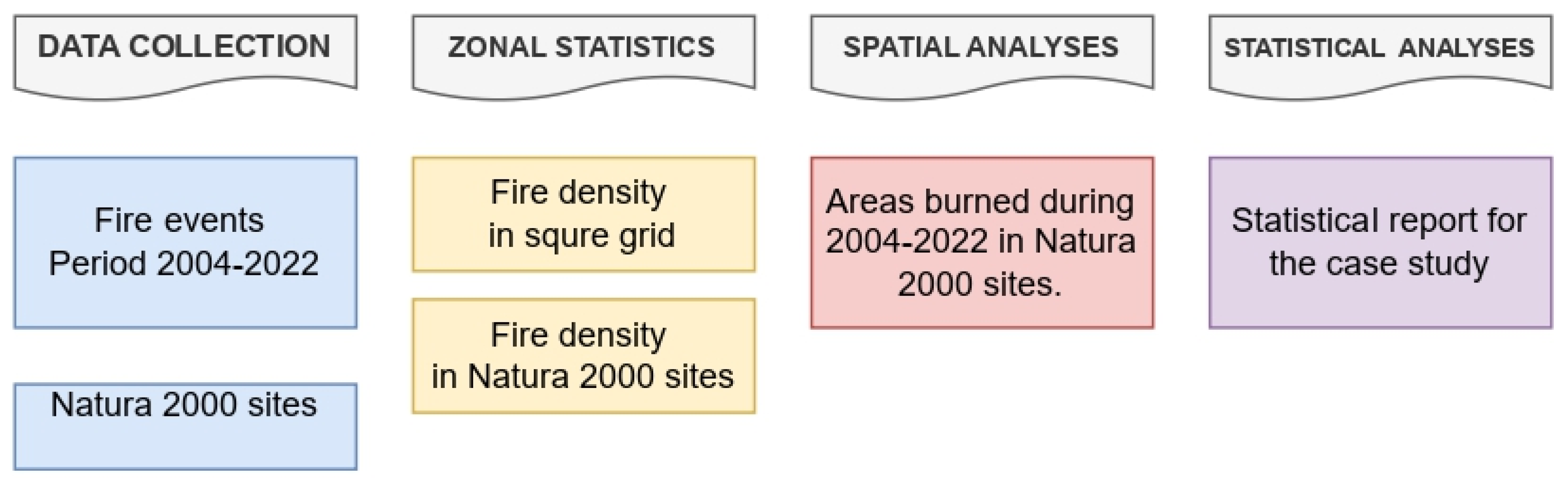
2. Materials and Methods
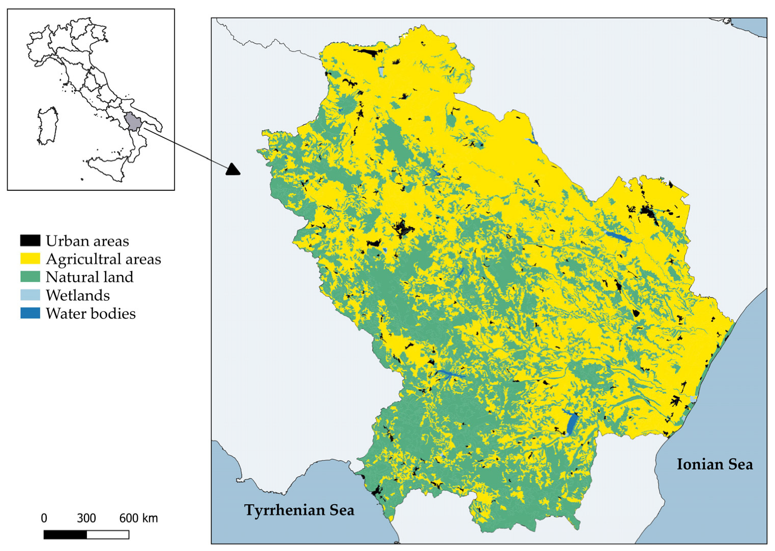
2.1. Study Area
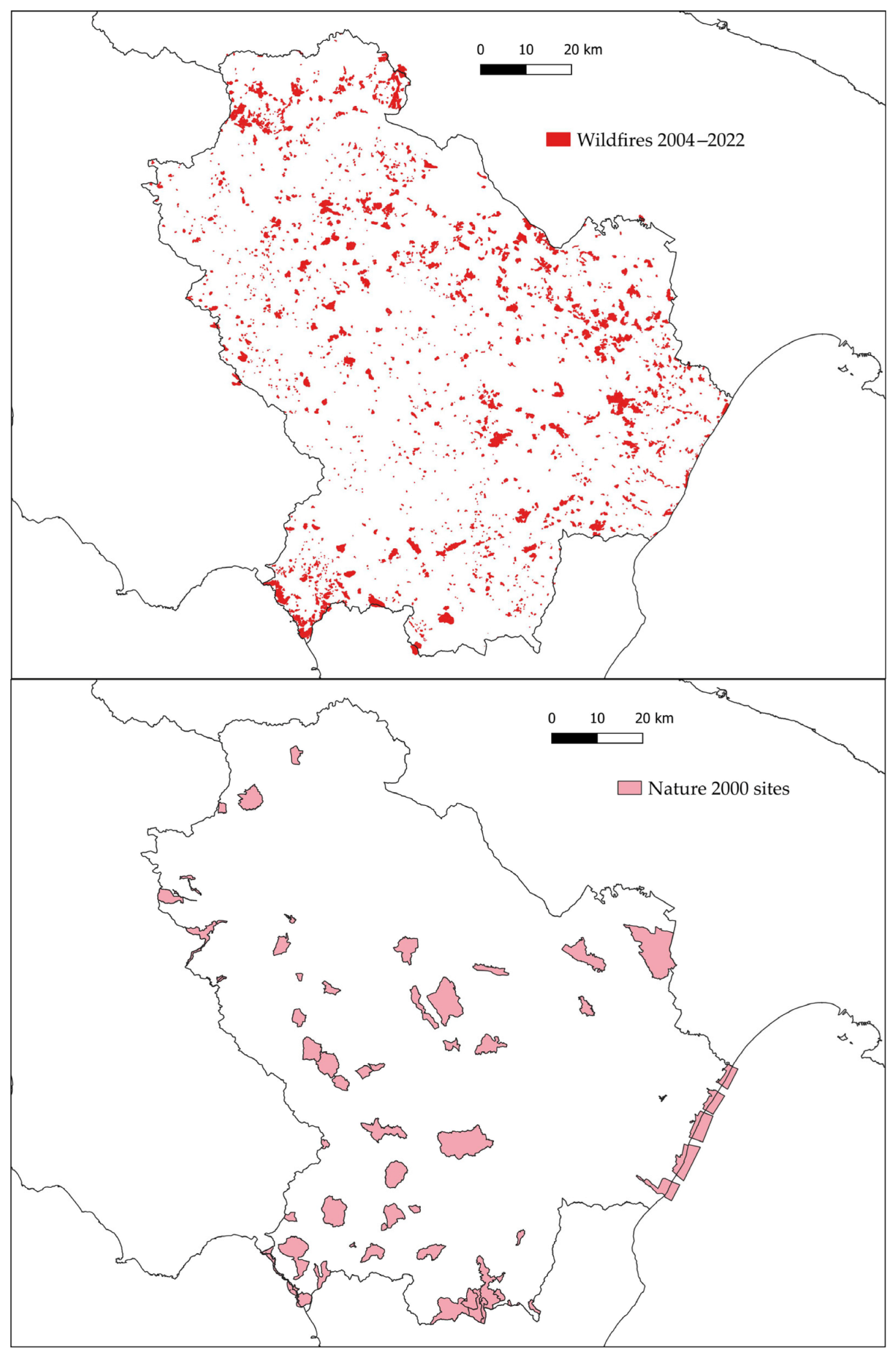
2.2. Datasets
2.3. Spatial Analysis Implementation
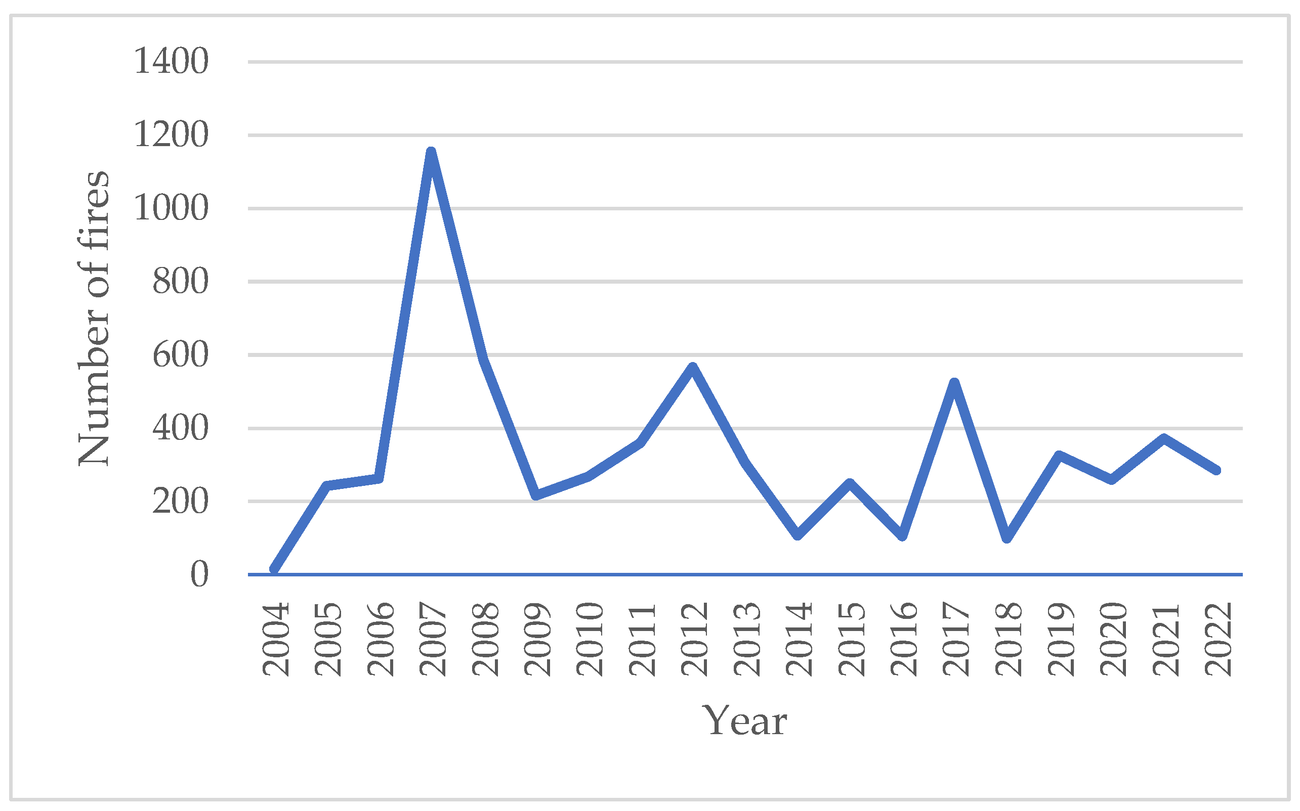
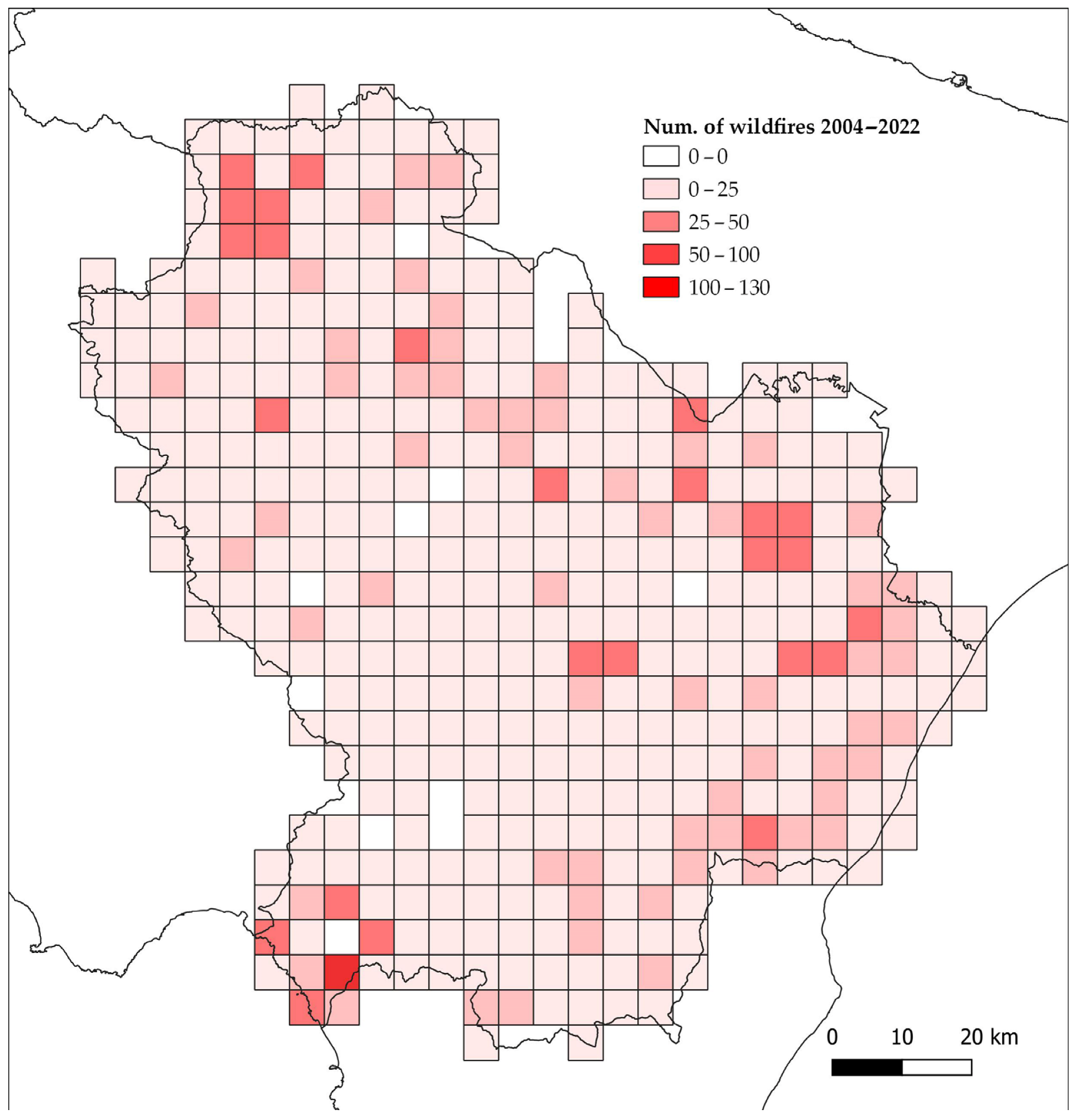
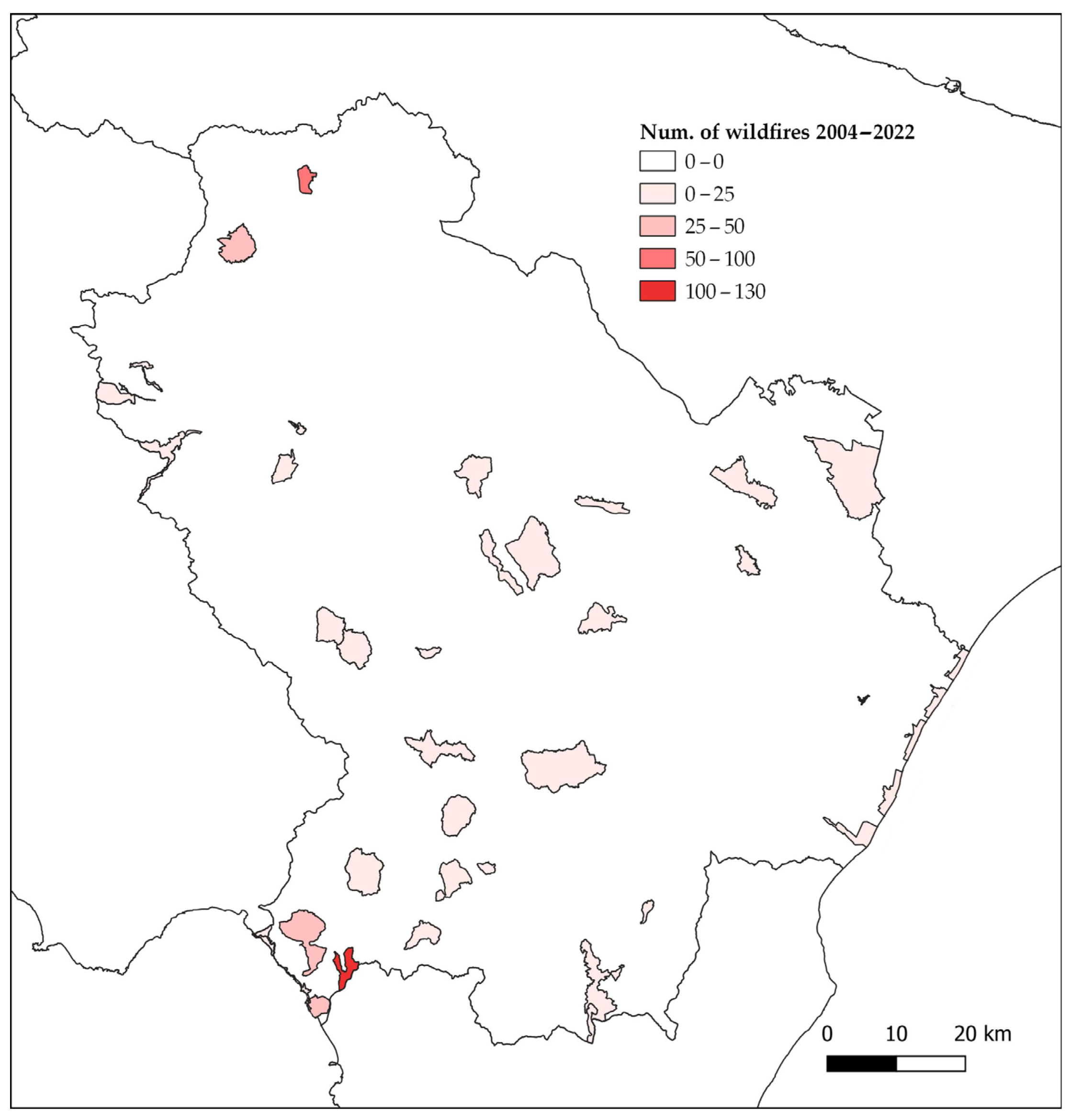
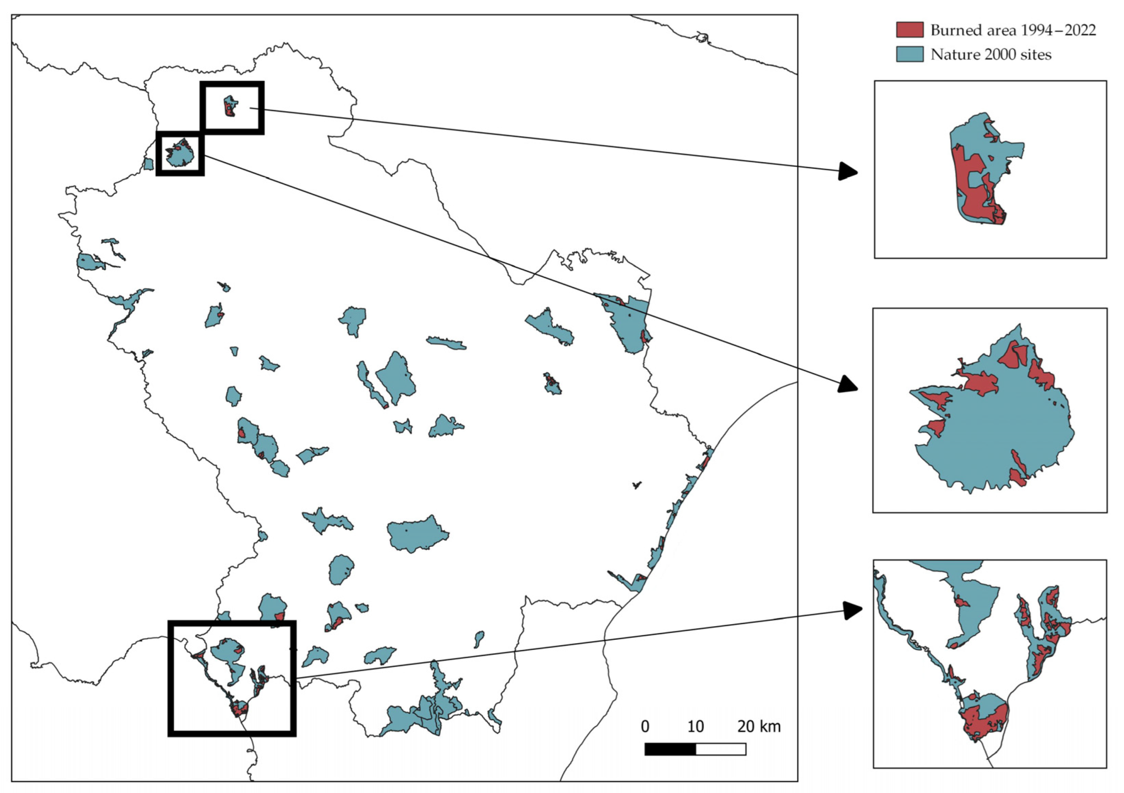
3. Results and Discussion
4. Conclusions
Author Contributions
Funding
Data Availability Statement
Conflicts of Interest
Appendix A

| Nature 2000 Site | ha Area | ha Fire | Fire % |
|---|---|---|---|
| Marina di Castrocucco | 810.72 | 381.46 | 47.05 |
| Lago del Rendina | 670.33 | 268.93 | 40.12 |
| Valle del Noce | 967.61 | 323.28 | 33.41 |
| Acquafredda di Maratea | 552.25 | 104.63 | 18.95 |
| Valle Basento Ferrandina Scalo | 732.94 | 138.40 | 18.88 |
| Monte Alpi—Malboschetto di Latronico | 1561.08 | 260.97 | 16.72 |
| Monte Vulture | 1903.98 | 258.02 | 13.55 |
| Costa Ionica Foce Bradano | 1155.65 | 152.59 | 13.20 |
| Serra di Calvello | 1641.35 | 157.80 | 9.61 |
| Monte Sirino | 2619.36 | 214.61 | 8.19 |
| Monte Coccovello—Monte Crivo—Monte Crive | 2981.11 | 213.29 | 7.16 |
| Monte Li Foi | 970.32 | 64.04 | 6.60 |
| Isola di S. Ianni e Costa Prospiciente | 417.67 | 25.83 | 6.19 |
| Bosco Pantano di Policoro e Costa Ionica Foce Sinni | 1794.10 | 95.74 | 5.34 |
| Dolomiti di Pietrapertosa | 1312.52 | 60.52 | 4.61 |
| Gravine di Matera | 6968.49 | 317.82 | 4.56 |
| Monte Volturino | 1858.45 | 80.18 | 4.31 |
| Bosco Vaccarizzo | 291.66 | 11.67 | 4.00 |
| Costa Ionica Foce Agri | 2414.68 | 91.68 | 3.80 |
| Costa Ionica Foce Basento | 1392.75 | 39.37 | 2.83 |
| Costa Ionica Foce Cavone | 2043.98 | 29.88 | 1.46 |
| Monte Paratiello | 1140.01 | 14.29 | 1.25 |
| Timpa delle Murge | 153.22 | 1.12 | 0.73 |
| Fosso La Noce | 43.29 | 0.31 | 0.71 |
| Abetina di Laurenzana | 324.39 | 2.10 | 0.65 |
| Bosco della Farneta | 297.95 | 1.50 | 0.50 |
| Lago S. Giuliano e Timmari | 2574.50 | 12.51 | 0.49 |
| Monte Raparo | 2019.97 | 9.65 | 0.48 |
| Valle Basento Grassano Scalo | 881.98 | 2.98 | 0.34 |
| Lago Pertusillo | 2042.04 | 4.99 | 0.24 |
| Abetina di Ruoti | 162.01 | 0.33 | 0.20 |
| Foresta Gallipoli—Cognato | 4288.78 | 4.53 | 0.11 |
| Murge di S. Oronzio | 5459.95 | 3.97 | 0.07 |
| Monte La Spina, Monte Zaccana | 1065.24 | 0.73 | 0.07 |
| Vallone Delle Ripe, Torrente Malta e Monte Giano | 344.32 | 0.03 | 0.01 |
| Monte di Mella-Torrente Misegna | 1565.17 | 0.16 | 0.01 |
| Serra di Crispo, Grande Porta del Pollino e Pietra Castello | 460.99 | 0.01 | 0.00 |
| Gole del Platano | 1383.10 | 0.02 | 0.00 |
| Lago Duglia, Casino Toscano e Piana di S.Francesco | 2425.89 | 0.00 | 0.00 |
| Bosco Cupolicchio | 1762.85 | 0.01 | 0.00 |
| Habitat Code | Num. of Fires | Habitat Code | Num. of Fires |
|---|---|---|---|
| 91M0 | 91 | 2110-2120-2230 | 6 |
| 9340 | 87 | 1240 | 6 |
| 6220 | 78 | 9250 | 4 |
| 6210 | 63 | 2250 | 4 |
| 5330 | 60 | 1310-1420 | 4 |
| 2260 | 39 | 3170 | 3 |
| 8210 | 28 | 1420 | 3 |
| 3280 | 24 | 1410-6420 | 3 |
| 9260 | 23 | 1210 | 3 |
| 8130 | 23 | 95A0 | 2 |
| 91AA | 22 | 6510 | 2 |
| 9220 | 19 | 6430 | 2 |
| 1410 | 19 | 4090 | 2 |
| 9210 | 17 | 1410-92D0 | 2 |
| 9180 | 14 | 1130 | 2 |
| 92D0 | 13 | 92A0 | 1 |
| 6210-62A0 | 8 | 91AA-9340 | 1 |
| 91F0 | 7 | 6170 | 1 |
| 9510 | 6 | 2250-2260-2230 | 1 |
| 62A0 | 6 | 1430 | 1 |
References
- Hoffmann, S. Challenges and Opportunities of Area-Based Conservation in Reaching Biodiversity and Sustainability Goals. Biodivers. Conserv. 2022, 31, 325–352. [Google Scholar] [CrossRef]
- Commission of the European Union. Council Regulation (EC) No 520/2021 of 19 March 2021. Official Journal of the European Union. EUR-Lex—Access to European Union Law. 2021. Available online: https://eur-lex.europa.eu/legal-content/EN/TXT/PDF/?uri=CELEX:52021XC1209(02)&from=EN (accessed on 4 May 2023).
- European Environment Agency. Natura 2000 Sites Designated under the Birds Directive (2009/147/EC) and the Habitats Directive (92/43/EEC). Available online: https://www.eea.europa.eu/ims/natura-2000-sites-designated-under (accessed on 4 February 2023).
- Lai, S. Hindrances to Effective Implementation of the Habitats Directive in Italy: Regional Differences in Designating Special Areas of Conservation. Sustainability 2020, 12, 2335. [Google Scholar] [CrossRef]
- San-Miguel-Ayanz, J.; Durrant, T.; Boca, R.; Maianti, P.; Libertà, G.; Artes Vivancos, T.; Jacome Felix Oom, D.; Branco, A.; De Rigo, D.; Ferrari, D.; et al. Forest Fires in Europe, Middle East and North Africa 2020, EUR 30862 EN; Publications Office of the European Union: Luxembourg, 2021. [Google Scholar]
- Tedim, F.; Leone, V.; Amraoui, M.; Bouillon, C.; Coughlan, M.R.; Delogu, G.M.; Fernandes, P.M.; Ferreira, C.; McCaffrey, S.; McGee, T.K.; et al. Defining Extreme Wildfire Events: Difficulties, Challenges, and Impacts. Fire 2018, 1, 9. [Google Scholar] [CrossRef]
- Sample, M.; Thode, A.E.; Peterson, C.; Gallagher, M.R.; Flatley, W.; Friggens, M.; Evans, A.; Loehman, R.; Hedwall, S.; Brandt, L.; et al. Adaptation Strategies and Approaches for Managing Fire in a Changing Climate. Climate 2022, 10, 58. [Google Scholar] [CrossRef]
- Turco, M.; Bedia, J.; Di Liberto, F.; Fiorucci, P.; Von Hardenberg, J.; Koutsias, N.; Llasat, M.C.; Xystrakis, F.; Provenzale, A. Decreasing fires in Mediterranean Europe. PLoS ONE 2016, 11, e0150663. [Google Scholar] [CrossRef] [PubMed]
- Regos, A.; D’Amen, M.; Titeux, N.; Herrando, S.; Guisan, A.; Brotons, L. Predicting the future effectiveness of protected areas for bird conservation in Mediterranean ecosystems under climate change and novel fire regime scenarios. Divers. Distrib. 2016, 22, 83–96. [Google Scholar] [CrossRef]
- Folharini, S.; Vieira, A.; Bento-Gonçalves, A.; Silva, S.; Marques, T.; Novais, J. Bibliometric Analysis on Wildfires and Protected Areas. Sustainability 2023, 15, 8536. [Google Scholar] [CrossRef]
- Rodríguez, G.L.; Vicente, V.R.; Pérez, M.F.M. Influence of the Declaration of Protected Natural Areas on the Evolution of Forest Fires in Collective Lands in Galicia (Spain). Forests 2022, 13, 1161. [Google Scholar] [CrossRef]
- San-Miguel-Ayanz, J.; Durrant, T.; Boca, R.; Camia, A. Forest Fire Damage in Natura 2000 Sites 2000–2012. EUR 25718 EN; Publications Office of the European Union: Luxembourg, 2012. [Google Scholar]
- Arellano-del-Verbo, G.; Urbieta, I.R.; Moreno, J.M. Large-Fire Ignitions Are Higher in Protected Areas than Outside Them in West-Central Spain. Fire 2023, 6, 28. [Google Scholar] [CrossRef]
- Pulido, F.; Corbacho, J.; Bertomeu, M.; Gómez, Á.; Guiomar, N.; Juárez, E.; Lucas, B.; Moreno, G.; Navalpotro, J.; Palomo, G. Fire-Smart Territories: A proof of concept based on Mosaico approach. Landsc. Ecol. 2023, 1–18. [Google Scholar] [CrossRef]
- Canadas, M.J.; Leal, M.; Soares, F.; Novais, A.; Ribeiro, P.F.; Schmidt, L.; Delicado, A.; Moreira, F.; Bergonse, R.; Oliveira, S.; et al. Wildfire mitigation and adaptation: Two locally independent actions supported by different policy domains. Land Use Policy 2023, 124, 106444. [Google Scholar] [CrossRef]
- Foresta, M.; Carranza, M.L.; Garfì, V.; Di Febbraro, M.; Marchetti, M.; Loy, A. A systematic conservation planning approach to fire risk management in Natura 2000 sites. J. Environ. Manag. 2016, 181, 574–581. [Google Scholar] [CrossRef] [PubMed]
- Imbrenda, V.; Lanfredi, M.; Coluzzi, R.; Simoniello, T. A Smart Procedure for Assessing the Health Status of Terrestrial Habitats in Protected Areas: The Case of the Natura 2000 Ecological Network in Basilicata (Southern Italy). Remote Sens. 2022, 14, 2699. [Google Scholar] [CrossRef]
- The World Bank. Sustainable Development Goals and Open Data. Available online: https://blogs.worldbank.org/digital-development/sustainable-development-goals-and-open-data (accessed on 3 February 2023).
- Cillis, G.; Lanorte, A.; Nolè, G.; Santarsiero, V.; Ronco, F. Fire planning of urban-rural interface in open source GIS environment: Case study of the Apulia region (Southern Italy). Int. Arch. Photogramm. Remote Sens. Spat. Inf. Sci. 2022, XLVIII-4/W1, 97–102. [Google Scholar] [CrossRef]
- European Commission, Joint Research Centre (JRC). Fire Database in the European Forest Fire Information System (Version 2-3-1). Available online: http://data.europa.eu/89h/678deb39-e35f-4236-a984-42d69bf95dec (accessed on 2 February 2023).
- Artés, T.; Oom, D.; de Rigo, D.; Durrant, T.H.; Maianti, P.; Libertà, G.; San-Miguel-Ayanz, J. A global wildfire dataset for the analysis of fire regimes and fire behaviour. Sci. Data 2019, 6, 296. [Google Scholar] [CrossRef] [PubMed]
- Lanorte, A.; Cillis, G.; Calamita, G.; Nolè, G.; Pilogallo, A.; Tucci, B.; De Santis, F. Integrated approach of RUSLE, GIS and ESA Sentinel-2 satellite data for post-fire soil erosion assessment in Basilicata region (Southern Italy). Geomat. Nat. Hazards Risk 2019, 10, 1563–1595. [Google Scholar] [CrossRef]
- Regione Basilicata. Catalogo RSDI. Available online: https://rsdi.regione.basilicata.it/Catalogo/srv/ita/search?hl=ita (accessed on 25 January 2023).
- Breunig, M.; Bradley, P.E.; Jahn, M.; Kuper, P.; Mazroob, N.; Rösch, N.; Al-Doori, M.; Stefanakis, E.; Jadidi, M. Geospatial Data Management Research: Progress and Future Directions. ISPRS Int. J. Geo-Inf. 2020, 9, 95. [Google Scholar] [CrossRef]
- Birch, C.P.; Oom, S.P.; Beecham, J.A. Rectangular and hexagonal grids used for observation, experiment and simulation in ecology. Ecol. Model. 2007, 206, 347–359. [Google Scholar] [CrossRef]
- Moreira, F.; Leal, M.; Bergonse, R.; Canadas, M.J.; Novais, A.; Oliveira, S.; Ribeiro, P.F.; Zêzere, J.L.; Santos, J.L. Recent Trends in Fire Regimes and Associated Territorial Features in a Fire-Prone Mediterranean Region. Fire 2023, 6, 60. [Google Scholar] [CrossRef]
- European Environment Agency (EEA). European Union Nature Information System (EUNIS). Available online: https://eunis.eea.europa.eu/index.jsp (accessed on 4 March 2023).


| Year | n. | Year | n. |
|---|---|---|---|
| 2004 | 16 | 2013 | 305 |
| 2005 | 242 | 2014 | 107 |
| 2006 | 262 | 2015 | 250 |
| 2007 | 1156 | 2016 | 105 |
| 2008 | 586 | 2017 | 525 |
| 2009 | 216 | 2018 | 99 |
| 2010 | 268 | 2019 | 326 |
| 2011 | 360 | 2020 | 259 |
| 2012 | 567 | 2021 | 372 |
| 2022 | 285 |
| Nature 2000 Site | Num. of fires | Nature 2000 Site | Num. of Fires |
|---|---|---|---|
| Valle del Noce | 104 | Lago S. Giuliano e Timmari | 8 |
| Lago del Rendina | 83 | Monte Paratiello | 6 |
| Monte Vulture | 40 | Murge di S. Oronzio | 5 |
| Marina di Castrocucco | 38 | Foresta Gallipoli—Cognato | 4 |
| Monte Coccovello—Monte Crivo—Monte Crive | 26 | Monte Li Foi | 4 |
| Gravine di Matera | 24 | Serra di Calvello | 4 |
| Costa Ionica Foce Agri | 21 | Costa Ionica Foce Basento | 3 |
| Acquafredda di Maratea | 18 | Bosco Cupolicchio | 2 |
| Bosco Pantano di Policoro e Costa Ionica Foce Sinni | 15 | Bosco della Farneta | 2 |
| Costa Ionica Foce Bradano | 14 | Gole del Platano | 2 |
| Costa Ionica Foce Cavone | 14 | Monte Raparo | 2 |
| Isola di S. Ianni e Costa Prospiciente | 13 | Serra di Crispo, Grande Porta del Pollino e Pietra Castello | 2 |
| Bosco Vaccarizzo | 12 | Valle Basento Grassano Scalo | 2 |
| Monte Alpi—Malboschetto di Latronico | 12 | Abetina di Laurenzana | 1 |
| Monte Sirino | 11 | Abetina di Ruoti | 1 |
| Valle Basento Ferrandina Scalo | 11 | Fosso La Noce | 1 |
| Dolomiti di Pietrapertosa | 10 | Lago Duglia, Casino Toscano e Piana di S.Francesco | 1 |
| Lago Pertusillo | 10 | Monte di Mella-Torrente Misegna | 1 |
| Monte Volturino | 9 | Monte La Spina, Monte Zaccana | 1 |
| Timpa delle Murge | 1 | ||
| Vallone Delle Ripe, Torrente Malta e Monte Giano | 1 |
Disclaimer/Publisher’s Note: The statements, opinions and data contained in all publications are solely those of the individual author(s) and contributor(s) and not of MDPI and/or the editor(s). MDPI and/or the editor(s) disclaim responsibility for any injury to people or property resulting from any ideas, methods, instructions or products referred to in the content. |
© 2023 by the authors. Licensee MDPI, Basel, Switzerland. This article is an open access article distributed under the terms and conditions of the Creative Commons Attribution (CC BY) license (https://creativecommons.org/licenses/by/4.0/).
Share and Cite
Cillis, G.; Lanorte, A.; Santarsiero, V.; Nolè, G. Natural Hazard Impact in Protected Areas for Resilience Management: The Case of Wildfires in the Basilicata Region. Pollutants 2023, 3, 437-450. https://doi.org/10.3390/pollutants3040030
Cillis G, Lanorte A, Santarsiero V, Nolè G. Natural Hazard Impact in Protected Areas for Resilience Management: The Case of Wildfires in the Basilicata Region. Pollutants. 2023; 3(4):437-450. https://doi.org/10.3390/pollutants3040030
Chicago/Turabian StyleCillis, Giuseppe, Antonio Lanorte, Valentina Santarsiero, and Gabriele Nolè. 2023. "Natural Hazard Impact in Protected Areas for Resilience Management: The Case of Wildfires in the Basilicata Region" Pollutants 3, no. 4: 437-450. https://doi.org/10.3390/pollutants3040030