Review

Air Traffic Management as a Vital Part of Urban Air Mobility—A Review of DLR’s Research Work from 1995 to 2022 †

German Aerospace Center (DLR), Institute of Flight Guidance, Lilienthalplatz 7, 38108 Braunschweig, Germany
*
Author to whom correspondence should be addressed.
This review has previously been presented at the German Aerospace Congress, DLRK 2022, Dresden, Germany, 27–29 September 2022.
Aerospace 2023, 10(1), 81; https://doi.org/10.3390/aerospace10010081
Submission received: 16 October 2022 / Revised: 16 December 2022 / Accepted: 22 December 2022 / Published: 14 January 2023
(This article belongs to the Special Issue Urban and Regional Air Mobility Research)

Abstract

:
Urban air mobility is a rapidly growing field of research. While drones or unmanned aerial vehicles have been operated mainly in the private and military sector in the past, an increasing range of opportunities is opening up for commercial applications. A new multitude of passenger-carrying drone or air taxi concepts promises to fulfill the dream of flying above congested urban areas. While early research has been focusing on vehicle development, solutions for urban air traffic management are lagging behind. This paper collects and reviews the main findings of past urban-air-mobility-related research projects at the German Aerospace Center (DLR) to serve as a basis for ongoing research from an air traffic management perspective.

1. Introduction

Urban Air Mobility (UAM) is defined as an air transportation system for passengers and cargo in and around urban environments by EASA (European Union Aviation Safety Association) [1]. As of today, in 2022, EASA expects first UAM operations to take place in European cities in three to five years. The delivery of goods will most likely be among the first commercial services to be offered and passenger transport will follow at a later stage. While initial services are supposed to be offered with piloted vehicles, remotely controlled or autonomous flights could also become possible according to EASA [2]. In order to safely operate these new types of vehicles, they have to be integrated into the existing airspace. A variety of research projects with the participation of the German Aerospace Center (DLR) (see Figure 1 and Table 1) had this scope, of which this paper provides an overview.
The paper starts in Section 2 with a retrospect on the time when helicopters became commercially available and were the then-new airspace users. Special focus is given to their effect on airport capacity and on rotorcraft-specific procedure design as well as the necessary pilot-assistance systems for meeting navigation performance requirements. Section 3 introduces drones as novel airspace users. The challenge of airspace integration is addressed and technologies for increased automation and conflict detection are reviewed. Coming from unmanned to passenger carrying drones, Section 4 deals with the hype of urban air mobility related to passenger transport. Self-piloted “easy to fly” vehicles are also addressed. Finally, Section 5 summarizes ongoing UAM-related research projects at DLR with a focus on air traffic management, Section 6 discusses the results and Section 7 concludes the main findings of this review paper.

2. Rise of the Helicopter

The first rotorcraft took off at the beginning of the 20th century but it took until World War II for the helicopter to unfold its full potential [3]. At that time, researchers, designers and city planners dreamed of helicopter passenger services above the urban skies. In the 1950s, when helicopters became available for commercial operations, many cities dreamed of incorporating helicopter services in urban areas. Examples can be found in [4] for the UK cities of London and Birmingham. In the 1960s and 1970s several cities such as San Francisco, Los Angeles and New York had regular helicopter services being offered [5]. In a NASA study from 1977, Dajani et al. [6] predicted that helicopter passenger services could fill the gap between existing short-haul commercial aviation and high-speed ground transportation systems. Helicopters were suggested to be used especially for alternate airport access as well as urban and intercity operations.
Nevertheless, by the 1980s most existing urban helicopter passenger services were terminated. Government subsidies had ended and made the rather costly, noisy and dangerous helicopter operations inefficient compared to emerging mass transportation systems such as subways or rail lines. Some major cities such as San Francisco even completely banned helicopters from city centers except for emergency operations [5]. Today, helicopters are mainly present in urban environments for medical emergency operation, law enforcement or VIP (very important person) passenger transport.
The idea of Urban Air Mobility (UAM) services was taken up again in 2016 by Voom [7], an Airbus company. Voom initiated a prototype concept for air taxis as extended urban helicopter services. Regular flights were offered in Sao Paulo (Brazil), Mexico City and the Bay Area (USA). Due to the COVID-19 pandemic the Voom project was terminated in 2020. Voom claims to have operated the first mobile helicopter-booking platform with the goal to extend access to UAM for a diverse pool of customers. The experience serves as inspiration for the development of air vehicles specially tailored for such operations. Established manufacturers, such as Airbus and Boeing, are currently testing concepts for electrically powered vehicles with vertical lift-off and landing abilities (eVTOL). In summary, more than 700 conceptual eVTOL designs by 350 different companies or inventors have been catalogued by the Vertical Flight Society [8] and new ones are continuously being added.
Next to the vehicles themselves, their safe integration into the airspace is vital for introducing additional traffic operations. The first air traffic control rules were established in the 1920s [8]. Today, Air Traffic Control (ATC), Air Space Management (ASM), Air Traffic Flow Management (ATFM) and Air Traffic Services (ATS) form the ATM system [9]. With an increasing number of flights, the air traffic management (ATM) system was expanded to a system consisting of air route traffic control centers and airport traffic control towers [10]. Since the early years of ATM, the dominant airspace users have been fixed-wing aircraft. From an ATM perspective, integrating helicopters, or in general vertical take-off and landing vehicles (VTOL), into the air traffic flow is a challenge due to their special performance characteristics compared to fixed-wing aircraft resulting in non-optimal usage of airport capacity.

2.1. Tackling Airport Congestion

During the early 1990s Europe’s airport and air traffic management system was experiencing severe capacity issues. Several research initiatives were started to tackle the problem. One of them was funded by the EC DG VII under the title “Study on potential benefit to airport/ATM congestion through special operational procedures for rotorcraft” (1994–1995, Project Consortium: Eurocopter (lead), Agusta Westland as helicopter manufacturer, DFS Deutsche Flugsicherung Gmbh, Aeroport de Paris, TU Braunschweig and DLR, funded by the European Commision DG VII.) [11]. It focused on possibilities to integrate large helicopters and tilt-rotor aircraft to relieve airport/ATM congestion at large airports. The study elaborated state-of-the-art (=1994) equipment and procedures as well as on a future scenario of 2015. In both time horizons rotorcraft arrivals and departures were operating on arrival and departure routes perpendicular to the fixed-wing runway directions.
DLR concentrated on scenario development and a capacity increase simulation for Frankfurt airport. Three possible evolution cases were considered for large rotorcraft traffic: The Add-on Case assuming additional traffic generated by rotorcraft, the Replacement Case where rotorcraft replace short-haul fixed-wing aircraft and the Slot-fill Case, where freed slots are filled by heavy fixed-wing aircraft.
Rotorcraft were operating either from and to an existing helipad close to the runways or a new location at sufficient distance to the existing runways to allow independent operation [1]. For the 2015 scenario minimum separation values were assumed to reduce to 1.5 NM (radar) or 3 NM (wake vortex).
The added rotorcraft traffic lead to up to forty additional rotorcraft movements per hour. As fixed-wing and rotorcraft have significantly different transport capacities a new capacity indicator was introduced, the slot weight capacity SWC. SWC took not only the added slot capacity into account but also the payload processed. The major finding was that a significant SWC increase of 33% and 42% was observed for today’s (1994) visual operations and instrument operations in 2015, respectively, but only if the new VTOL site had a sufficient distance from the fixed-wing runways [12].
From a 2022 perspective it is obvious that large rotorcraft and tiltrotor aircraft have not been introduced in considerable numbers for the anticipated transport tasks. In addition, the anticipated separation reductions for radar as well as for wake vortex separations have not been reached up to now. Minimum radar separation for consecutive landings is still at 2.5 NM and minimum wake vortex separation values are between 3 and 8 NM depending on the weight classes of leading and following aircraft. The current DLR research SupeRO (Super Close Runway Operations) introduces a new concept to overcome these limitations by focusing on minimal lateral separation [13].
On the other hand, the required GNSS (Global Navigation Satellite System) navigation has been established and the design principle to separate fixed-wing aircraft and rotorcraft operations as far as possible is still valid.

2.2. Rotorcraft-Specific Procedure Design

The European project OPTIMAL (Optimized Procedures and Techniques for IMprovement of Approach and Landing) (2005–2007, Project consortium: DLR, INECO, AIRBUS, THALES ATM, ISDEFE, NLR, AENA, EUROCONTROL, THALES Avionics, AGUSTA, DFS, LVNL, ENAV, SICTA, partly funded by the European Commission under grant agreement no. 502880.) aimed to define and validate innovative procedures for the approach and landing phases of aircraft and rotorcraft in a pre-operational environment [14]. In particular, for rotorcraft, Simultaneous Non-Interfering (SNI) procedures allowing fully independent aircraft/rotorcraft traffic streams were considered. Increasing the ATM capacity while maintaining and even improving safety was one goal of this project. Another objective was to minimize external aircraft/rotorcraft noise nuisance. Those achievements were enabled by new technologies such as SBAS and/or GBAS (Satellite-/Ground Based Augmentation System) as well as available precision-approach landing aids such as ILS and MLS (Instrument/Microwave Landing System). At that time, the DLR Institute of Flight Guidance demonstrated the rotorcraft system’s 4D flight guidance capabilities. For these advanced interoperability flight trials, DLR’s research helicopter EC135 was equipped with an SBAS receiver and a special 4D-capable experimental rotorcraft flight management system (FMS) using a 4D referenced flight guidance. SBAS offers a performance comparable to an ILS CAT I without requiring any specific installation on the ground and consequently is well-adapted to rotorcraft IFR (Instrument Flight Rules) operations at isolated helipads such as, for example, hospitals or helidecks. In the framework of the flight trials the practical flyability of the helicopter-specific steep and curved time-referenced IFR approach procedures were confirmed. The approach procedures were initially developed for Bremen airport (EDDW). Vertical guidance allowed a precise height control throughout the final descent and reduced the risk of collision with terrain at night or in bad weather conditions. Approaches with vertical guidance are known as being much safer than laterally guided NPAs (Non-Precision Approaches) referring to worldwide aircraft accident statistics [15].
In OPTIMAL, two different guidance concepts were validated: a tunnel-in-the-sky and a bug guidance added to a PFD (primary flight display).
The tunnel-in-the-sky display shows the predefined flight route in the form of a virtual 3D tunnel to increase the pilot’s situation and mission awareness (Figure 2). The tunnel coordinates are based on the time-based trajectory which is generated by the trajectory generator of the FMS considering the performance parameters of the helicopter. The Bug-PFD-guidance display is based on a standard PFD display which is extended by guidance parameters for speed, altitude and heading (Figure 2).
In total four flight days with 49 approaches to Bremen airport were arranged to validate these two different display formats. The wind conditions varied between 2 and 5 kts from variable direction to 18 kts from 195°. The SBAS system gave a high-precision position and all flight tests were executed as had been determined in the pre-flight preparations.
Regarding the performance of the tunnel-in-the-sky display, the vertical FTE (flight technical error) was about 10 m and the lateral FTE was lower than 25 m—this was close to the desired performance.
The flight technical errors with the use of the modified PFD guidance display (without tunnel guidance) were much higher, because the pilot has to bring the current altitude, speed and heading values in line with the commanded values. This produces a higher workload. In contrast to the PFD display the pilot can operate easily inside the area of the tunnel display to feel confident operating inside an obstacle-free area.
Similar display concepts were also investigated and validated by flight trials in later projects, e.g., GRADE (2018–2019, Project consortium: CIRA, BULATSA, DLR, MATS, NAIS, TUBS, UNIPARTH, ISSNOVA, funded by the EU Horizon 2020 / SESAR Joint Undertaking, grant agreement no. 783170) or SESAR2020 project “Enhanced Arrival and Departures” (PJ.01 EAD) (2017–2019, Project consortium: Airbus Helicopters, Thales Avionics, DLR, funded by the SESAR Joint Undertaking.). The operational scope of the exercises conducted in the first above-mentioned project GRADE was to demonstrate the feasibility and benefits of executing SESAR 1 solution Sol#113, which covers the demonstration of Standard Point-In-Space (PinS [16]) helicopter procedures as well as low-level IFR routes (LLR) for helicopters [17]. The concept of PinS is a flight operation based on GNSS and designed for helicopters only. It relies on the possibility for the pilot to conduct flights under Instrument Meteorological Conditions (IMC) to/from a PinS and not directly to/from the heliport. Those procedures enable heliport or landing site operators to implement IFR procedures on non-instrument FATO (Final Approach and Take-Off) located on aerodromes or isolated heliports as well as landing locations. It was also demonstrated that the PinS procedure can be conducted independently from approaching fixed-wing traffic, resulting in a Simultaneous Non-Interfering operation [17]. For guiding the pilot along the planned flight route, different display formats of a primary flight display (PFD, Figure 3), navigation display (NAV) and Synthetic Vision System display (SVS, Figure 4) were customized and finally tested on a head-down display on DLR’s HubSim simulator in the scope of a real-time simulation.
The objective of the demonstration was to show the flyability of the designed Low-Level IFR routes as well as the designed PinS procedure. The flight trials included a Low-Level IFR routing from the urban area in Braunschweig to a helipad at Braunschweig-Wolfsburg airport and were supported by slightly modified guidance displays compared to what was used within the real-time simulations (see Figure 2 and Figure 3). These modifications focused on the extension of “Standard” to “Advanced” (e.g., curved) PinS procedures using RF (Radius-to-Fix) legs. RF legs are fixed-radius curve elements and provide a repeatable track over the ground. Advanced PinS instrument approach procedures, as opposed to the classical PinS, further utilize RF leg types when transitions between straight segments of different ground tracks are desired. With advanced PinS these RF legs can be placed in the intermediate approach up to the final approach point (FAP), after the initial departure fix (IDF) and after the missed approach point (MAPt).
Data analysis showed that, in general, for all flights under PFD with course deviation indicator (CDI) configuration, pilots tend to react later to deviations from the route. With tunnel-in-the-sky guidance the lateral accuracy was always much better than RNP 0.1 (Required Performance Navigation of 0.1 (RNP 0.1) means that the rotorcraft’s navigation system must be accurate within a circle with a radius of 0.1 nautical miles) except for two flights close to the start of the procedure. The ratings for situational awareness (SA) barely showed enough SA for the PFD and fair ratings for the tunnel-in-the-sky guidance display. It can be argued that, in comparison with the tunnel-in-the-sky guidance display, pilots felt much less aware of their situation and what pilots stated as being “behind” the helicopter. This shows that with CDI guidance pilots always have to reduce an already built-up deviation. It was much easier with a tunnel-in-the-sky guidance display to prevent a deviation to build up at all.
Regarding the task load analysis (NASA-TLX), the PFD provoked much more workload for the pilots than the tunnel-in-the-sky guidance. Nevertheless, the variation in the ratings for the PFD was very high.
The benefit of advanced PinS was further assessed and validated within the framework of the SESAR2020 project “Enhanced Arrival and Departures” (PJ.01 EAD). Three exercises were conducted to demonstrate and analyze two different enabling technologies. Exercises one and two integrated a synthetic vision system (SVS) together with a Helmet-Mounted Display (HMD) supporting manual flight that can increase the safety and reliability of rotorcraft operations through dedicated symbology for specific rotorcraft operations, especially during arrival and departure operations including visual segments. With the same scope the third exercise used an IFR-certified avionics suite (Helionix®, Honeywell Aerospace, Phoenix, AZ, USA), including a flight management system (FMS) and a four-axis autopilot to automatically fly an advanced PinS procedure [18].
The objective was to analyze the benefit of Satellite-Based Augmentation System (SBAS)-based navigation for advanced PinS Required Navigational Performance (RNP) approaches and departures to/from Final Approach and Take-Off (FATO) areas. Furthermore, the corresponding rotorcraft-specific contingency procedures in case of loss of communication were defined. As the SBAS navigation, the corresponding contingency procedures will need to comply as much as possible with profiles adapted to exploit rotorcraft performance and reduce fuel consumption and noise emission. The pilot was supported during these operations by dedicated symbology presented on a helmet-mounted display. In addition, the new procedures were validated in nominal and non-nominal conditions with and without autopilot coupling. The procedures also helped to reduce the noise of approaches in populated areas, and for rotorcraft to operate close to airports without coming into conflict with fixed-wing traffic or requiring runway slots.
Separately at Airbus Helicopters facilities in Donauwoerth, flight trials with curved and steep approaches were performed with a four-axis autopilot coupling to achieve a high degree of automation and thereby significant crew workload reduction in the approach and departure phases. During these trials, the pilots assessed and validated the benefit of integrating such vision systems and advanced autopilot modes to support the pilots. Consequently, safety and reliability of rotorcraft operations were increased. The pilots also evaluated the benefit of having SBAS navigation for advanced PinS RNP 0.3/LPV (Localizer Performance with Vertical Guidance) approaches and departures to and from the FATO area.

3. Drones Enter the Airspace

With the introduction of unmanned aerial systems (UAS), also known as drones, a new era of aviation arose in the 1990s. The technology started off by providing new capabilities for military applications as well as in the consumer leisure market. Ever since, an increasing range of commercial applications has been investigated. In the USA the Federal Aviation Administration (FAA) initiated the implementation of a traffic management system for unmanned air traffic (UTM) [19]. The European drones outlook study [20] estimates 400,000 drones being in service in Europe by 2050. In order to integrate these new airspace users, the European Commission (EC) launched the initiative to establish U-space [21], a framework for enabling safe, efficient and secure access to airspace for large numbers of drones. U-space also includes a UTM.

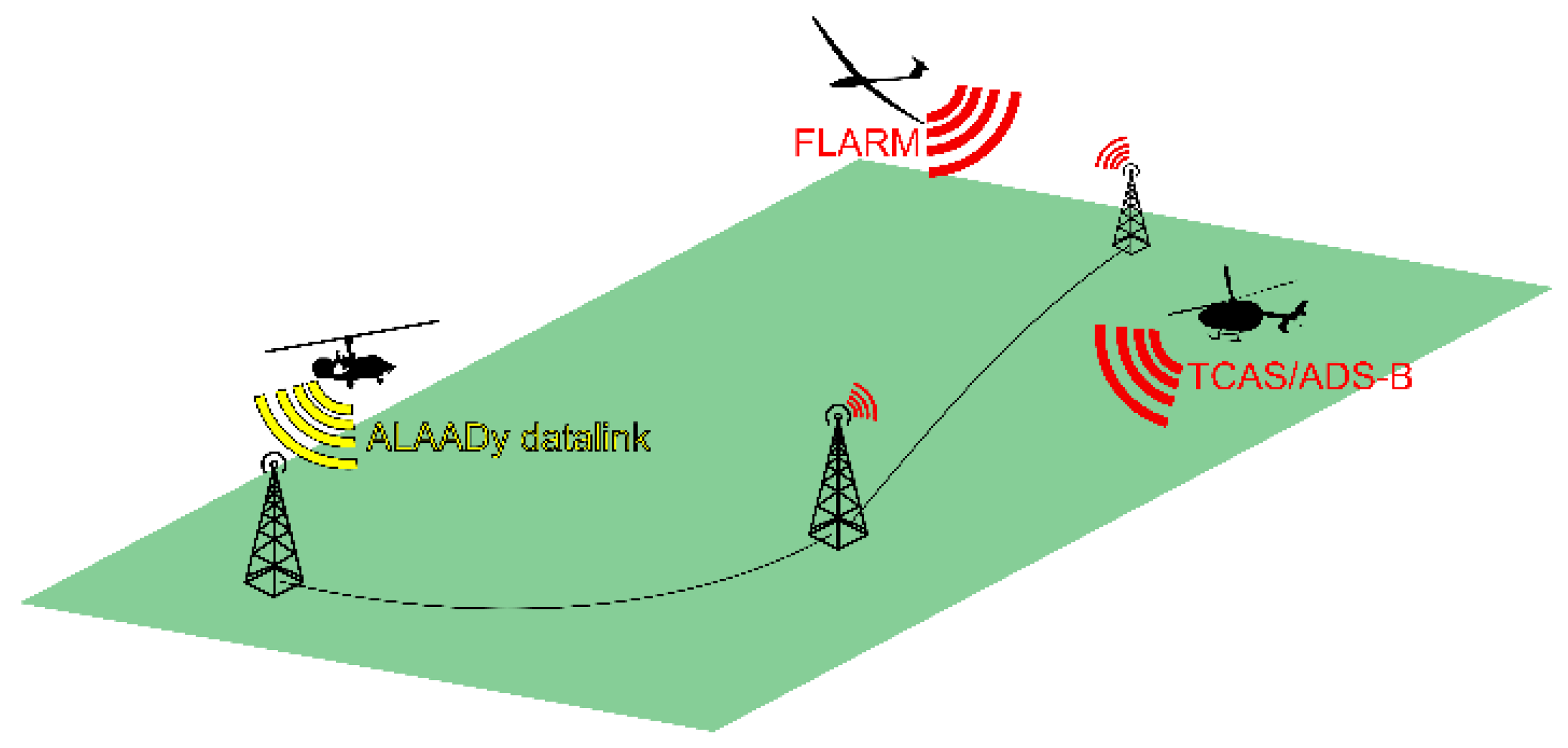
3.1. The Challenge of Integrating Drones into the Airspace

The vision of a complete integration of new air traffic participants with conventional manned air traffic, already declared in the “European ATM Master Plan” [22], envisages a flexible, scalable system for manned and unmanned aviation supported by a digital ecosystem, full air–ground system integration, distributed data and services, and high levels of automation and connectivity among all actors. This vision is to be divided into different phases based on U-space and is planned to be realized by 2040.
Complementing the “European ATM Master Plan” from 2020, the “Strategic Research and Innovation Agenda (SRIA)” [23] describes the resulting Research and Innovation (R&I) objectives for the next years based on the vision outlined in the European ATM Master Plan. The most important challenges and R&I needs mentioned for the full integration of drones are:
  • Maturation, validation and deployment of the fundamental U-space services (U1 and U2) across Europe
  • Development of advanced U-space services (U3 and U4) to enable UAS/UAM missions in high traffic density and complex scenarios
  • Enablement of UAM by developing concepts and solutions for the integration of autonomous operations over populated, complex and congested airspace environments
  • Definition of systems and interfaces for a seamless integration of ATM, UAM and U-space
  • Development of concepts and solutions considering social acceptance, environmental impacts and sustainability (e.g., UAM noise, visual pollution, privacy, emissions and recycling/resource management)
  • Elaboration of concepts for U-space application above the Very Low Level (VLL) airspace
SRIA plans a European development and implementation of U-space with initial UAM applications and integration into existing ATM processes within a time horizon of 2030. Several EU projects are already working on solutions for the above-mentioned challenges. DLR has several ongoing projects with institutional funding, e.g., ALAADY-CC, City-ATM and HorizonUAM, which already focus on finding feasible concepts and solutions for traffic and airspace management, while considering various requirements with regard to social acceptance, safety and environmental compatibility.
Alongside those projects, DLR has already conducted or is preparing field studies to measure the social acceptance from different perspectives (e.g., passengers, pedestrians, home owners, car drivers) and to measure drone noise as a function of different vehicle configurations and flight maneuvers. DLR has also proposed a density-based U-space management system to open up the airspace equally for UAS with low equipment levels as well as for those with higher standards of equipment [24].
A first concept of operation for U-Space was proposed in [25] in the project CORUS. The DLR internal project CityATM (2018–2021. Project consortium: DLR (5 institutes/facilities), in cooperation with NXP, FlyNex GmbH, DFS Deutsche Flugsicherung GmbH, Auterion AG, Zentrum für Angewandte Luftfahrtforschung GmbH, KopterKraft. Institutional funding) deals with the practical application of the investigated U-space services in simulation and flight tests. Operational and technical concepts for airspace management, information provision, traffic flow control and monitoring, as well as infrastructure for communication, navigation and surveillance were defined, simulated and validated in three flight-testing phases: a bridge inspection with multiple drones in the center of the city of Hamburg, dynamic geofencing [26] and safe drone operation in dense traffic [27] were demonstrated. The projects i-LUM [28] and UDVeo [29] are further elaborating a prototypical UTM for the use case Hamburg.
Another important challenge for the full integration of drones is the upcoming implementation of the U-space EU regulation into national regulations in January 2023. On the one hand, every EU nation already has its own national law that needs to be adapted carefully to protect the interests of already-established air traffic actors while fostering new and innovative air traffic solutions and supporting the vision of a new air mobility. This might result in individual interpretations and national adaptations of the U-space Regulation to meet the specific requirements on a national level. On the other hand, different initiatives and regulatory bodies foresee these developments and try to elaborate guidelines for the implementation of U-space (see EASA’s Draft on U-space Acceptable Means of Compliance (AMC) and Guidance Material (GM) [30]). Nevertheless, harmonization of U-space has several aspects, ranging from U-space airspace definition itself (from airspace class to geographical zones), roles and responsibilities of actors (esp. Air Traffic Control ATC, U-space Service Provider USSP and Common Information Service Provider CISP), singularity of CISP and USSP or cross-border applicable interfaces and data that could be shared between different U-space implementations.

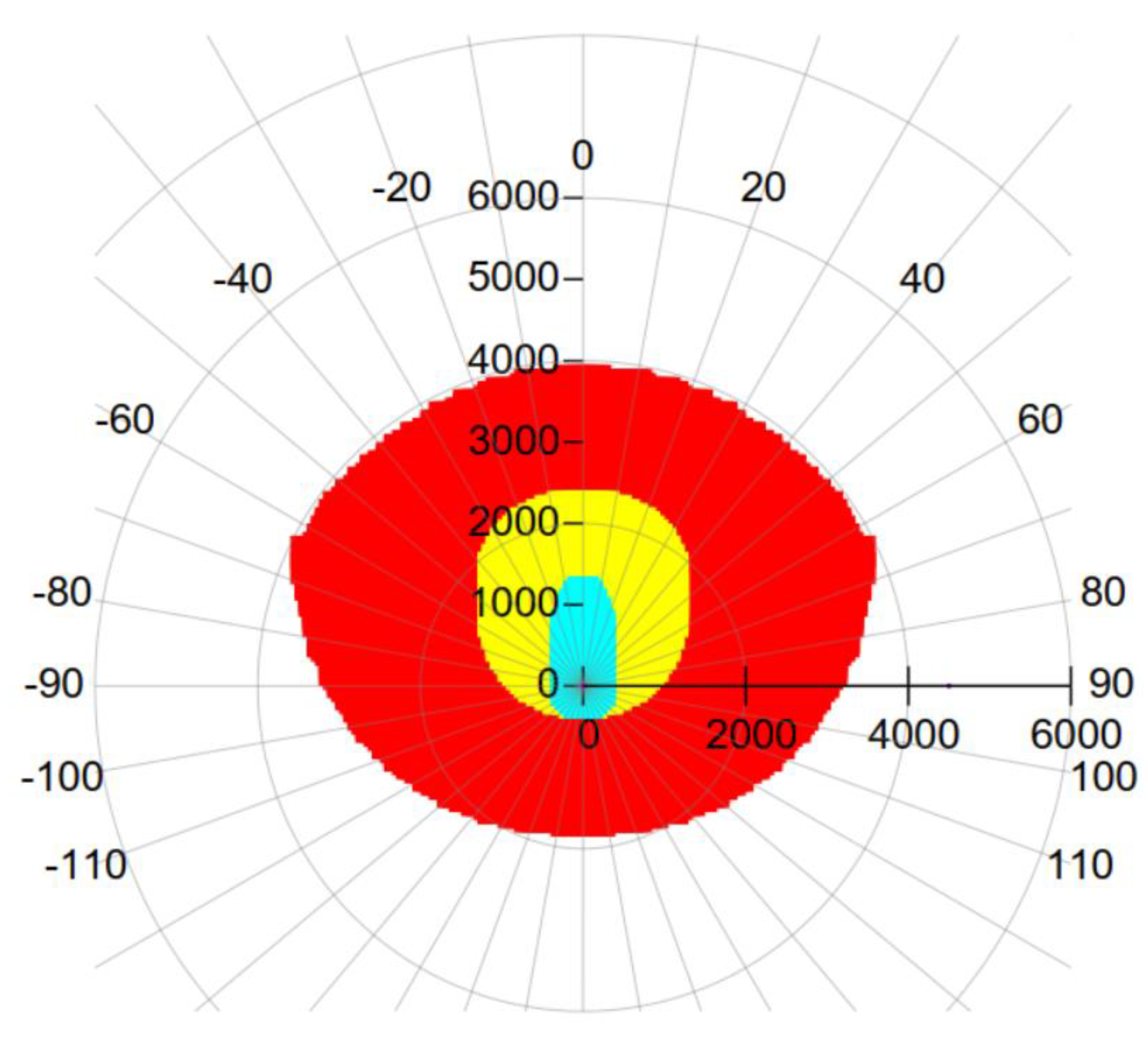
3.2. Increased Automation and Conflict Detection

The aim of the DLR project ALAADy (2016–2019. Project consortium: DLR (7 institutes/facilities), institutional funding) [31] was to fully define and examine the possibilities of a large drone with a payload capacity of above 500 kg in terms of technical feasibility, operational integration and economic efficiency. To this end, seven institutes and divisions of DLR have been involved in the project. Unmanned freight operations had previously been investigated in the project UFO [32]. While not being a UAM project from the beginning, ALAADy and its successors have contributed a number of essential building blocks for forthcoming UAM research. In the following we will summarize some essential findings of the project.
The first result was an early concept for integrating large drones into the existing airspace [31]. The key idea of ALAADy was based on the use of airspace G (and VLL) for cargo drone operations. This is motivated by the fact that a lower altitude usually means a more direct access to a potentially unmanned vehicle, and a smaller possible impact in case of an emergency situation. Consequently, the concept included ideas to keep away from inhabited areas on the ground (minimizing the ground risk), and to use cooperative transponders such as TCAS (Traffic Alert and Collision Avoidance System), ADS-B (Automatic Dependent Surveillance Broadcast) and FLARM (Flight Alarm) to produce a commonly shared traffic awareness for all participants in a given airspace. This led to the concept of a dedicated airspace “G+”, that is, a part of airspace G providing a traffic awareness service that is available and mandatory for every vehicle inside, see Figure 5. This idea ultimately evolved into concepts now found in U-space [25], namely in the form of services such as “Tracking” and “Monitoring”.
Further, ALAADy identified challenges and possible solutions for detect-and-avoid (DAA) especially for larger unmanned vehicles. This comprised a review of state-of-the-art cooperative DAA solutions and the development of methods to specify requirements for those systems given a range of vehicles very different from previous aviation. The state of the art at that time mainly comprised cooperative transponder technology such as ADS-B and FLARM. As described, the project suggested to merge these into a common service (now known as “Tracking” in U-space) and further add position information from smaller drones that are available via their individual C2 links (Command and Control). This required a more or less complete coverage for the data-link used. ALAADy suggested to use the latest mobile communication standard, which was 4G-LTE (4th Generation Long Term Evolution) at that time. Further, modifications were suggested that can now be found in the 5G and forthcoming 6G standards.
More generally, requirements for minimal distances for DAA were investigated. This resulted in the suggestion of a performance-based safety volume for each airspace participant. Figure 6 shows an example of such a performance-based safety volume with three differently sized areas depending on the opponent’s velocity: The faster other aircraft are approaching, the larger the safety volume has to be.
Requirements and frameworks for onboard safety monitoring and an overall safe operation of a partly autonomous vehicle were also assessed [31]. During flight, a number of pre-defined limits for variables of the vehicle state are monitored to assure the correct working of these functions. The result is a safe operation. One example for an operational limit is geofencing. Geofencing prevents an unmanned aircraft from entering a forbidden airspace using virtual fences. ALAADy developed an algorithm and described parameters for a safe buffer distance to use in geofencing. Further, the use of a formal specification language and simulation results that support the verification and validation of safety variables was devised. The chosen specification language is not limited to geofencing; other operational limits can be expressed and monitored in-flight to assure safe operation.
A wide range of options for technically realizing autonomous vehicles with cargo payloads above 250 kg is shown in [31]. Figure 7 shows a choice of different frames and builds for a large cargo drone. Each of these is based on a different lift technology resulting in its very own decisions for energy supply and propulsion, which again resulted in different endurance, payload capacity and efficiency. Starting from top-right in clockwise order the following options are shown: gyrocopter, boxed-wing and fixed-wing. Beyond that, it was determined if, e.g., blimps and ultra-light technologies could be an option. Further, safety aspects for emergency landings were taken into consideration (as shown in the figure), e.g., parachutes, spiral glide-path landing and autorotation landing. Ultimately, for the project’s scope the gyrocopter design was chosen since it proved to have the best compromise of performance, efficiency and safety.
For all other designs, key aspects driving this decision have been documented to assist future decisions that might be motivated by other use cases (e.g., passenger transport vehicles).
ALAADy has inspired a number of follow-up projects, as well as initiated software that has been successfully used in these projects. Aspects of a modular on-board avionics and functional blocks defined therein have found further development in a European context [33]. Beyond that, the aspect of conflict detection and conflict-free planning has been investigated [34]. While strategic conflict avoidance has been identified as a major service in U-space it has also been stated that DAA will play a role as one of the main capabilities in U-space that complement the given services [25]. The aspect of DAA and the related area of remain well-clear (RWC) has been recently investigated [35,36]. Software developed in these contexts has been re-used in later investigations [37]. Further, ideas from ALAADy as well as from the aforementioned density-based approach [24] have found their way into more recent projects: In the EU project USEPE (2021–2022. Project consortium: ISDEFE (lead), Nommon, Universitetet i Sørøst-Norge, DLR, Leibniz Universität Hannover, POLIS, Indra Navia AS. Funded by European Commission H2020 / SESAR Joint Undertaking under grant agreement no. 890378.) a combined concept integrating the U-space density-based approach is tested. This again has inspired the definition of a metric for comparing aerial traffic scenarios [38], and the investigation of safe DAA ranges in constrained areas such as urban environments [39]. An actual operational cargo drone prototype was built in ALAADy-Demo (2016–2019. Project consortium: DLR (3 institutes/facilities), institutional funding.) (see Figure 8). This unmanned cargo gyrocopter demonstrator is further elaborated in the project ALAADy-CC (2022–2024. Project consortium: DLR (6 institutes/facilities), institutional funding.) (cross country).

4. The Hype of Urban Air Mobility

With drones becoming technically feasible and advancements in the development of electric engines, the dream of electric passenger drones, also called eVTOL (electric Vertical Take-off and Landing) arose. Until 2022, more than 700 eVTOL concepts have been published [40]. UAM was officially declared as “hype” with Gartner [41] publishing their annual hype cycle for emerging technologies. In 2019, here “Flying autonomous vehicles” were to be found in the middle between the phases of innovation trigger and the peak of inflated expectations. An overview of the multitude of current UAM research activities is provided in [42].

4.1. Self-Piloted Personal Aerial Vehicles

The 2011–2014 research project myCopter (2011–2014. Project consortium: MPI for Biological Cybernetics (lead), UoL, EPFL, ETHZ, KIT, DLR. Funded by EU 7th Framework Programme, grant agreement no. 266470.), funded by the European Union (EU), was initiated before UAM was hyped in the media. It was one of the first on so-called Personal Aerial Vehicles (PAV) [43]. The underlying idea was to make flying a rotorcraft as easy as driving a car today. In future use cases, minimally trained pilots should be able to privately operate their PAV. To investigate the requirements, selected enabling technologies for personal aerial transportation were analyzed. DLR focused on vehicle technology and pilot assistance investigations. A steering wheel control concept was developed and tested extensively in piloted simulations, see Figure 9. The steering wheel concept resulted in reduced workload for helicopter pilots and minimally trained PAV pilots compared to conventional rotorcraft controls [44]. The underlying control laws were evaluated in ground-based simulation as well as in real flight on DLR’s in-flight simulator FHS, a highly modified EC135 helicopter. Additional pilot assistance systems such as a tunnel or so-called highway-in-the-sky navigation display (Figure 10) were investigated by the consortium [45,46]. Similar display concepts had also been investigated for helicopter pilots as described in Section 2.2. Path-planning [47] as well as automatic landing place detection [48] were assessed with drones replacing the PAV by the project partners of myCopter. The problem of ATM was addressed in discussions and identified as a potential bottleneck for implementation of UAM but no further research could be conducted at that time.

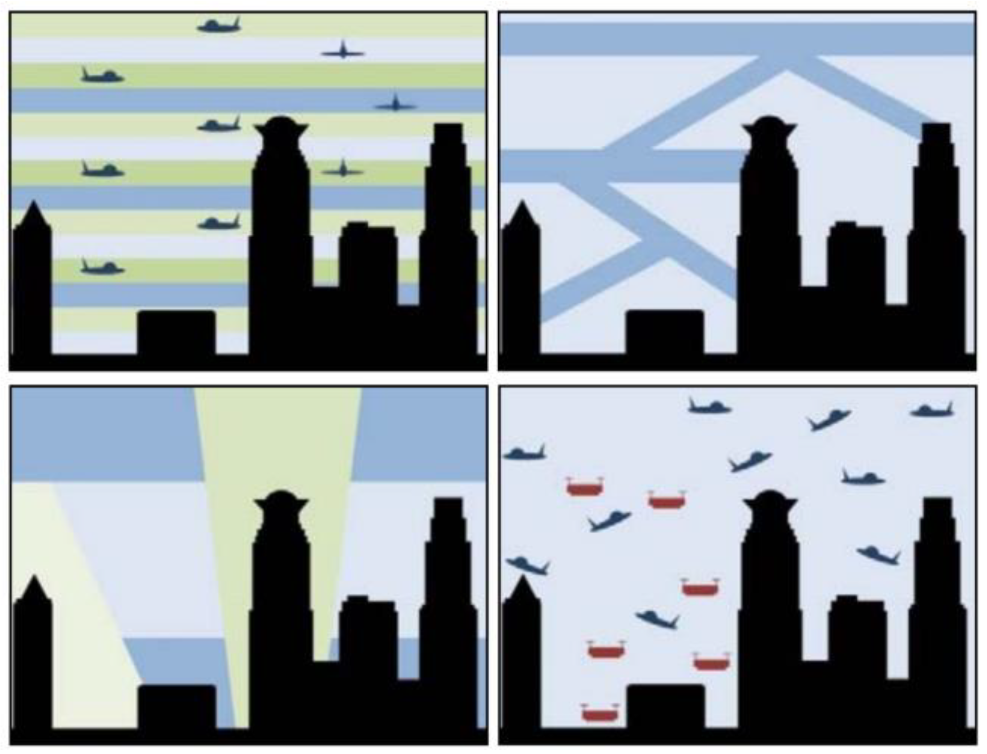
4.2. Airspace Management for High-Density Operations

Deeper insight into future ATM concepts could be gained within the European project Metropolis (2013–2015. Project consortium: TU Delft (lead), DLR, ENAC, NLR. Funded by EU 7th Framework Programme, grant agreement no. 341508.) [49]. Here, the research focus was no longer on the vehicle itself but on the underlying management system. Even extreme traffic densities were simulated considering personal as well as unmanned aerial vehicles. Assuming high-density airspace operations, the influence of airspace structure on capacity, complexity, safety and efficiency were assessed. The Metropolis concept of operation considers four different airspace concepts: full mix, layers, zones and tubes [50].
In the early 2010s, it was expected that the development of mega cities would continue during the following decades and two new entrants would populate the airspace above these cities: PAV for individual passenger transport and UAV for parcel deliveries [50]. In Metropolis airspace design options for the urban environment were assessed to process the expected huge numbers of new airspace users in a safe and orderly manner. Within the project DLR concentrated on the ATM concept development and scenario definition [51].
Metropolis defined four mega city scenarios with 14, 18, 22 and 26 million inhabitants with 4% of the population to be expected to use PAVs by 2050. The per capita demand for UAV deliveries was set to 5.5 packages to be delivered per annum. Due to different performance characteristics, UAVs were supposed to use the airspace between 1100 ft and 1650 ft and PAVs were expected to fly between 1650 ft and 6500 ft above ground. Minimum separations were set to 250 m horizontally and 50 m vertically. Landing and take-off spots were placed on top of existing buildings or traffic infrastructure.
Four airspace concepts were defined to strategically separate and organize the traffic flows tactically as shown in Figure 11. They were all evaluated with regard to their effect on safety and capacity. In the “Full Mix” concept aircraft are allowed to take the direct path between origin and destination as well as their desired flight level. A deviation from the direct path is only necessary to avoid other aircraft, weather or obstacles such as terrain or buildings. The “Layer” concept extends the hemispheric rule of today’s fixed-wing air traffic by introducing layers with a heading range of 45° and a height of 300 ft. Shorter flights stay at the lower-level layer set while longer flights use the higher levels to reduce fuel burn. The “Zone” concept introduces a horizontal airspace structure with rings and radials around a city center creating a radial grid. A vertical segmentation is not foreseen. The concepts “Full Mix”, “Layers” and “Zones” use pairwise conflict resolution with a look-ahead time of 60 s and resolution options to change heading, altitude or speed of the aircraft. The fourth concept “Tubes” introduces four-dimensional tubes with a fixed route structure and a time-based conflict resolution only.
The four concepts were implemented for PAV operations in NLR’s (Netherlands Aerospace Center) traffic simulator TMX covering a 40 × 40 nautical miles portion of the fictional Metropolis city. UAV operations were simulated with the “Full Mix” concept due to their short-haul traffic characteristics in the vicinity of package-distribution centers.
The simulation results indicated that the “Layer” concept achieved the safest operations by inducing the lowest number of intrusions per flight (a safety indicator) and almost the same route efficiency as the “Full Mix” concept. The “Zones” and “Tubes” concepts had significantly lower efficiency values as well as higher conflict and intrusion values.

5. Ongoing Research

Several national and international projects have so far provided valuable results for the integration of UAM into the airspace. UAM integration was investigated from different perspectives (e.g., collision avoidance, airspace structure, flight rules, separation management or emergency management) and several solutions were developed and demonstrated successfully. Those pieces now need to be put together and aligned to form an overall picture for a fair, safe, efficient future airspace system.

5.1. Concept Development and Operational Aspects

Building upon the U-space ConOps published in 2019 [25], CORUS-XUAM (2020–2022. Project consortium: Eurocontrol (lead), ADP, Aslogic, The British Light Aviation Centre Limited, DFS, DLR, Droniq, DSNA, ENAIRE, ENAV, Hemav Foundation, INDRA, Swedish Civil Aviation Administration, NATS, Pipistrel, SkeyDrone, UNIFLY, UPC, Volocopter. Funded by the SESAR Joint Undertaking.) is going to deliver an extended version in which passenger-carrying drone operations are considered to be conducted in urban and densely populated environments. In order to accommodate such operations, the existing European airspace structure and rules of the air, strategic and tactical processes as well as procedural and collaborative interfaces between involved stakeholders need to be re-evaluated and some of them need to be re-shaped in the long-term. A U-space ConOps “2.0” is expected which will be based on both conceptual analyses as well as first flight trials in a real U-space environment with full-size air taxis and delivery drones. This includes important insights regarding the technical feasibility of proposed solutions and faced challenges, the distribution of responsibilities inside U-space airspace and stakeholder interaction/interoperability.
Other current European projects, especially the new SESAR3 Joint Undertaking’s Digital Sky Demonstrators project “U-space European COMmon dEpLoyment (U-ELCOME)“ (2022–2025. Project consortium: EUROCONTROL (lead), DLR, ENAV, ENAIRE, Thales, Airbus, CRIDA, EUROUSC, CIRA, Honeywell (51 partners). Funded by European Commission’s Connecting Europe Facility.), will also perform a series of tests and demonstrations in various operational environments across 15 locations in Spain, Italy and France bringing together different U1 and U2 U-space services and solutions from related EU projects. The foundation services will cover e-registration, e-identification and geofencing (U1), and initial services for drone operations management, including flight planning, flight approval, tracking and interfacing with conventional air traffic control (U2). One of the main goals of U-ELCOME is to develop a scalable U-space architecture enabling the required level of information exchange and coordination among U-space service providers (USSPs) and between USSPs, ATM and vertiport using interoperable standards. This will allow for automated drone traffic management and situational awareness among all U-space stakeholders. U-ELCOME will therefore enable the next step towards implementing complete U-space foundation services for different real-life use cases. DLR will contribute to this ambitious project by providing guidelines for the harmonization and interoperability of different solutions and interfaces.

5.2. Bringing Together DLR Expertise on UAM

HorizonUAM (2020–2023. Project consortium: DLR (11 institutes), cooperation with NASA and BHL. Institutional funding.) [52] is a major collaborative research project at DLR that brings together the expertise of eleven individual institutes. This allows the consortium to evaluate the chances and risks of UAM from a system-of-system perspective. The UAM vehicle, infrastructure, operation and social acceptance are the four focus areas of HorizonUAM. The research focus of HorizonUAM lies on passenger transport use cases such as Intra-City, Sub-Urban-Commuter, Airport Shuttle, Inter-City and Mega-City flights [1]. In a first UAM implementation phase until 2025 it is expected that air taxis will be piloted, while for a mature UAM system after 2050 remote or fully autonomous vehicle operations are envisioned.
Once the vehicle-related challenges are resolved, the question of how to integrate UAM traffic into the existing airspace structures has to be addressed. In general, airspace is separated into low-level uncontrolled airspace as well as controlled airspace in higher altitudes as well as around airports and landing sites [8]. Due to their operations at low altitudes, UAM traffic, as current helicopter traffic, is able to operate mainly in uncontrolled airspace and thus independent of ATC [53]. However, when entering a control zone, for example to perform shuttle services to and from airports, direct contact with ATC is required given current aviation regulations [8]. Previous studies identified ATC workload as a major bottleneck for the scalability of UAM operations in controlled airspace [54,55]. In consequence, the ConOps of different aviation authorities (e.g., [18,54]) suggest independent UAM corridors controlled by an entity independent of the current ATC system or even an entire self-coordination among UAM vehicles within the corridors. Especially for the first development phases of the UAM systems, it is doubtful whether the required technical prerequisites will be available. An additional challenge is posed by the low operating altitude of UAM vehicles, which is highly exposed to drone and bird movements and will require novel approaches for collision avoidance [56]. For this purpose, one work package of the HorizonUAM project is investigating options for how to best support controllers of the current ATC system with controlling initial UAM traffic occurring in addition to their existing duties and how the increased probability of wildlife strikes might affect workflows. To set up a test case, a route network for shuttle services to and from Hamburg Airport (EDDH) was defined. Based on fast-time safety and capacity studies, a suitable vertiport site at the airport was identified [57,58]. Thereafter, controller procedures to integrate UAM traffic on those routes were defined. The control zone of Hamburg includes all of the city as well as the suburbs. Consequently, the entire UAM route network lies within the control zone and, due to current legislation [59], UAM vehicles have to contact ATC prior to take-off both from the airport as well as from the outside vertiports and need to be controlled throughout their entire flight. To support controllers in this additional workload, as well as in the coordination between conventional IFR traffic and UAM traffic, a set of controller support tools was developed [58]. These were validated with controllers in real-time human-in-the-loop simulations in autumn 2022.
A vertiport provides limited resources in terms of take-off and landing pads, parking spots and charging infrastructure; therefore, the vertiport represents one of the key infrastructure elements in a UAM network. An exemplary vertiport layout and its used terminology is displayed in Figure 12.
A vertiport’s real-time operational capability needs to be considered, not only during strategic/pre-tactical planning phases and active flight phases where tactical actions and deviations need to be accommodated, but also during demand and capacity evaluation and traffic flow optimization tasks. Since the vertiport describes a significant bottleneck especially for near-term UAM applications, a vertiport’s performance, operational capability and resilience are of great interest. In HorizonUAM, the vertiport is being examined in terms of regulatory and operational state of the art [60], exemplary layout designs and corresponding concept of operations for both low- and high-density throughput scenarios [61], performance-based rating of a vertiport’s airside operation [62] and a vertiport’s placement inside airport environment [57]. Furthermore, a vertiport network in an urban environment was developed and compared to ground-based traffic networks [37] and the development and validation of real vertiport prototypes and their operation inside a scaled urban environment suitable for flight testing [63] is envisaged.

5.3. Building a “U-Space Regulatory Sandbox”

DLR already has plans to continue the valuable research conducted in City-ATM and HorizonUAM. Both projects brought together the expertise of several research institutes and developed innovative concepts and technologies for the integration of drones and (e)VTOL into the current airspace. The SESAR Joint Undertaking has emphasized how important large-scale demonstrations are for the maturation of U-Space and UAM in Europe (call VLD2). Among the funded VLD2 projects are CORUS-XUAM, as already mentioned above, and Uspace4UAM, which aims at bridging the gap between development and deployment of U-space capabilities and services [64]. The SESAR project AMU-LED has held several open days for demonstrating air taxi flights [65] and has assessed U-space system models [66]. Furthermore, GOF 2.0 combines UAS, eVTOL and manned operations in urban airspace, SAFIR-MED focuses on medical air mobility applications, and TINDAIR seeks to demonstrate deconfliction methods [67].
In a next step, DLR plans to realize a “U-space Regulatory Sandbox” at its National Experimental Test Center for Unmanned Aircraft Systems. The Test Center is located at the commercial airport Magdeburg-Cochstedt (EDBC) and provides an ideal environment for the implementation of a U-space airspace. Together with several research institutes and external partners DLR will coordinate a four-year project to implement a U-space airspace, the necessary infrastructure and U-space services adapted to the geographical location of the airport Magdeburg-Cochstedt. In addition, a U-space simulation and virtualization environment will be provided, in which new and innovative solutions for U -space can be validated and experienced independently of a geographic location within different virtual environments. The focus of DLR’s work will be on the one hand the development and validation of advanced U-space services in close coordination with EASA’s guidelines and other related EU projects. Here, the interaction between different actors in U-space (esp. multiple USSPs, CISP, ATM) is an important aspect that will be closely investigated to elaborate recommendations and provide possible solutions. The active airport itself enables research on solutions and technologies for seamlessly integrating unmanned systems with manned aviation. Therefore, a model city [63] including multiple vertiports will be located in the airport’s vicinity. On the other hand, a virtual and augmented environment will be developed and demonstrated to enable not only mixed-reality flight trials in different surroundings, but also to give, e.g., urban developers, aviation authorities or local residents the opportunity to experience future mobility concepts.

6. Discussion

The AirportIV study from the 1990s concentrated mainly on the capacity-generating effect of introducing high-frequency rotorcraft operations at fixed-wing airports. One major result was a required sufficient distance between fixed-wing runways and flight paths on the one hand and rotorcraft landing and take-off sites on the other hand. Due to the considerable differences in transport capacities between rotorcraft and fixed-wing aircraft a modified capacity performance indicator is recommended and should be considered in developing today’s UAM integration at fixed-wing airports.
The Metropolis study delivered the first indications of a layered airspace concept as most suitable for high-density UAM operations. Open research questions were identified for parameter variation and specification as well as for enhanced conflict detection and resolution.
With regard to operational feasibility, procedures to integrate UAM traffic in existing control zones, e.g., around airports, is crucial. In real-time human-in-the-loop simulations taking place within the HorizonUAM project in autumn 2022, controller procedures and support tools were evaluated to support tower controllers when controlling UAM traffic in addition to their regular tasks. Initial results suggest that the integration may be feasible if regulations for separations are clearly specified when defining a clear route network for UAM traffic and if IFR and UAM traffic are flowing as independently as possible. With the latter two being highly dependent on the geography of a specific UAM region, further research should emphasize deriving general rules that can be adjusted to individual sites.
Currently, vertiports are mostly investigated on a strategic/conceptual and individual level. However, a UAM network consists of a set of vertiports, most likely with differing characteristics, capacities, concepts and layouts. Therefore, holistic UAM network simulation activities need to be carried out in order to understand the behavior and dynamics of a UAM network operation on a micro and macro level. For spring 2023, one of HorizonUAM’s objectives is to connect different modules (demand, mode selection, fleet, airspace and ground capacity management, etc.) in order to develop a holistic system-of-system analysis and to derive requirements regarding those individual elements based on a dynamic UAM network operation with on-demand UAM requests via fast-time simulation.
Summarizing the outcome of the definition and validation of Standard and/or Advanced PinS helicopter flight procedures, it can be stated with confidence that a combination of HMD system and autopilot can reduce pilot workload and greatly enhance situational awareness. Other projects are currently investigating the transmission of additional information via other perception channels (tactile, auditory) and how it leads to more benefit in accomplishing the mission task.
With regard to the operational concept of PinS procedures, there are still some restrictions in Germany for applying the PinS concept. Instrument flights for rescue helicopters are currently only permitted above a certain altitude and usually have to be detected by air traffic control radar from this altitude. Below this defined limit, visual flight is mandatory for pilots, and if the cloud base is too low, helicopters are therefore not allowed to take off. Even stricter values apply at night: If there are clouds at a height of less than 1200 ft (around 400 m), helicopters are currently not allowed to take off. The same rules would apply for piloted eVTOL in Germany. With the PinS method, significantly more operations in adverse weather conditions are possible, even when the cloud base is low. Projects such as ALAADy and ALAADy-Demonstrator have shown that the operation of larger cargo drones in mainland Europe is in principle possible. However, a number of open questions still need to be addressed, starting from the actual demand and the overall volume for such operations, going over the integration into the still-developing U-space, leading to questions of social acceptance and ecological feasibility. Since the start of these projects, concepts such as U-space and SORA have been heavily developed and underwent several revisions. The concepts devised in ALAADy will have to be revised under the perspective of an ever-changing legal and social environment.
From a European perspective one of the main challenges for the next years will be the harmonization of procedures, systems and requirements for cross-national U-space and UAM implementations. Here, a close coordination of implementation mechanisms and flexible systems to capture national implementation differences will be necessary to prevent isolated solutions and to foster the market uptake of innovative drone and air taxi applications across Europe. This will strongly depend on higher levels of digitalization and automation, especially with regard to the vision of a seamless integration of manned and unmanned traffic—and in the long-term with other transport modes (e.g., trains, trams, cars, ships) as well—in a future transport system. This vision is included in the EU Drone Strategy 2.0, while the needs and requirements identified to realize this vision were described in the SRIA for the Digital European Sky.

7. Conclusions

The review of UAM related air traffic management projects conducted at DLR has revealed the complexity of airspace integration concepts for different vehicle types and high-density operations in urban environments. The following conclusions can be drawn from the review.
  • Implementing UAM cannot be seen as a single discipline. A multidisciplinary approach is necessary for successful maturation of the existing concepts. For a functional UAM system not only do vehicle design and certification have to be mastered but also airspace integration, operational aspects, infrastructure requirements and public acceptance are to be considered.
  • It is expected that first implementations of UAM will rely on piloted vehicles that will benefit from improved pilot-assistance functionalities. At a later stage remotely controlled or autonomously operating vehicles bear the potential for an increase in capacity and efficiency.
  • The design principle to separate fixed-wing aircraft and rotorcraft operation as far as possible is still valid for the optimization of airport capacity.
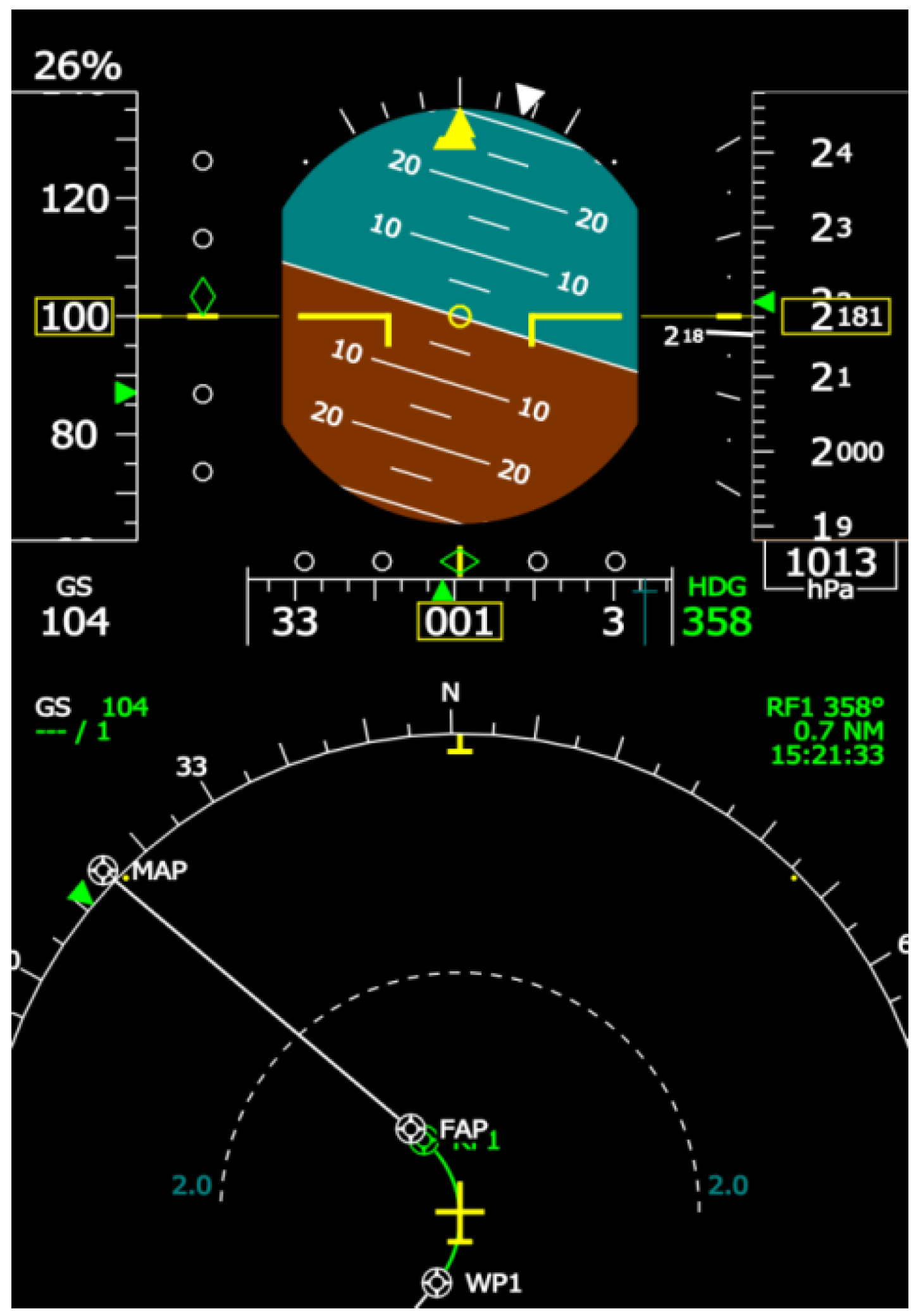
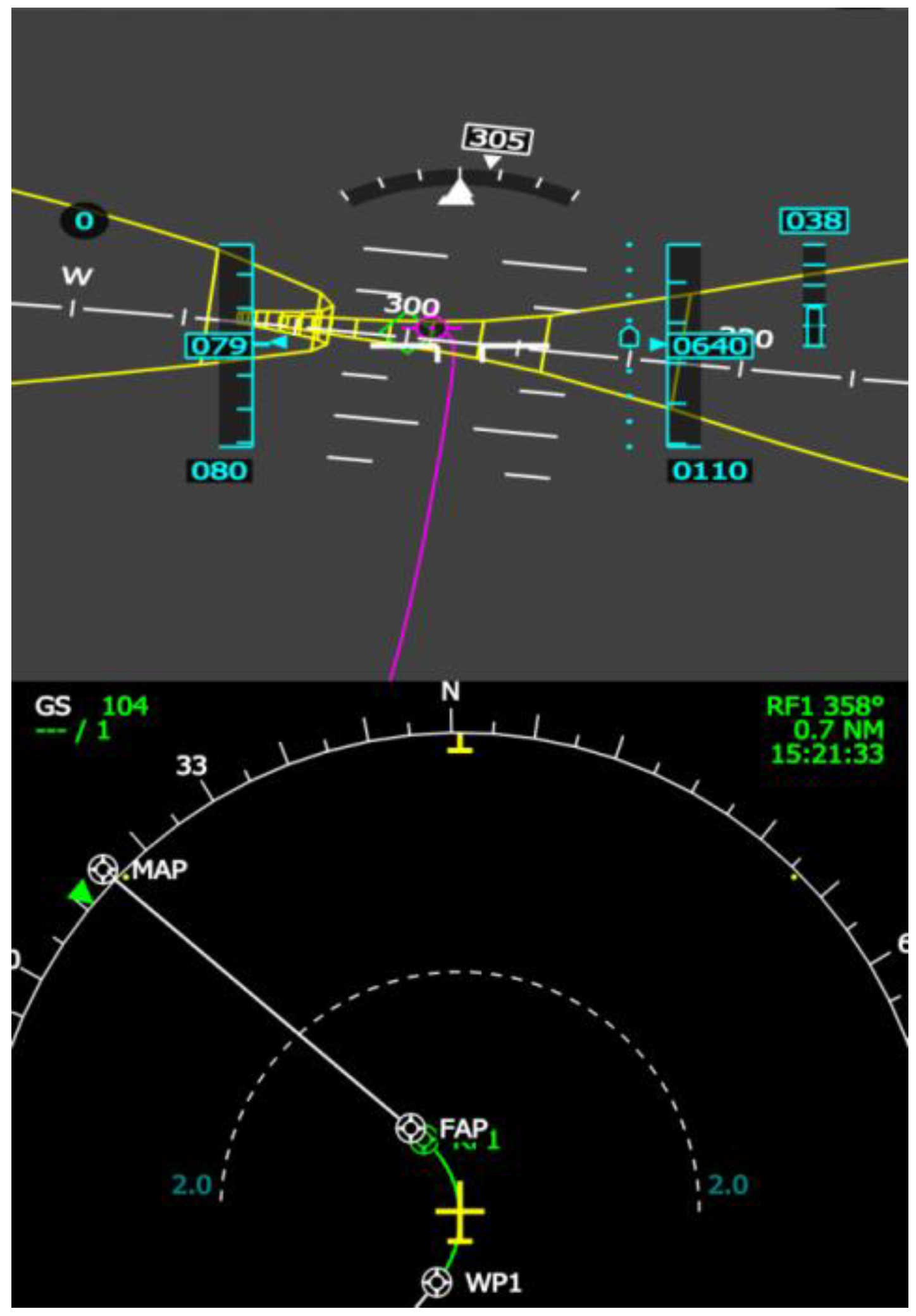
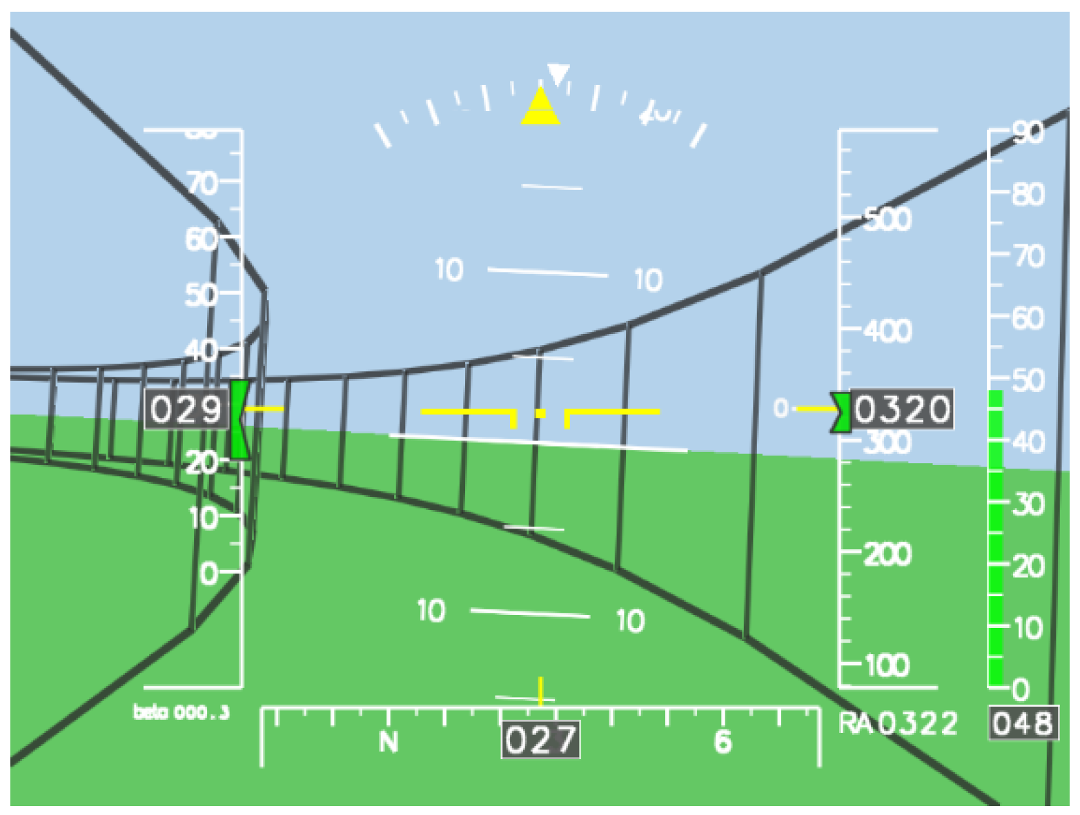
  • For piloted rotorcraft or VTOL operations, pilot displays such as tunnel-in-the-sky displays assist in reaching a better flight path accuracy compared to conventional primary flight displays when rotorcraft-specific approaches or noise-abatement procedures are to be flown. A combination of helmet-mounted display system and an autopilot coupling will further reduce pilot workload.
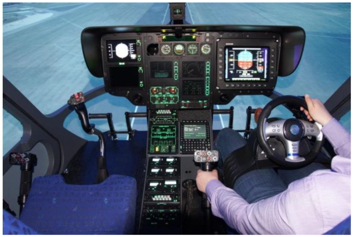
  • With increased autopilot assistance in highly augmented rotorcraft, non-conventional control concepts such as steering wheel control could further reduce pilot workload.
  • GBAS/SBAS-guided Point-in-Space (PinS) procedures for rotorcraft can be conducted independently from approaching fixed-wing traffic, resulting in a Simultaneous Non-Interfering (SNI) operation. They also help to reduce the noise of approaches in populated areas, and for rotorcraft to operate close to airports without coming into conflict with fixed-wing traffic or requiring runway slots.
  • An important challenge for the integration of UAS/UAM into the existing airspace is the upcoming implementation of the U-space EU regulation into national regulation in January 2023.
  • Ongoing research will have to focus on the development of advanced U-space Services (U3 and U4) as they are necessary to enable UAS/UAM missions in high traffic density and complex scenarios.
  • Strategic conflict avoidance has been identified as a major service in U-space. Detect and avoid services for tactical conflict avoidance will play a role as one of the main capabilities in U-space that complement the given services.
  • A “Layer” concept for UAM airspace management achieved the safest operations in simulation by inducing the lowest number of intrusions per flight compared to other concepts such as “Full Mix”, “Zones” or “Tubes”. Efficiency was high for both “Layer” and “Full Mix” concepts.
  • UAM traffic is supposed to operate mainly in uncontrolled or future U-space airspace and thus independently of air traffic control (ATC). However, when entering a control zone at an airport direct contact with ATC is required given current aviation regulations. Supporting systems for ATC controllers are needed in order to cope with the increasing workload due to additional UAM traffic.
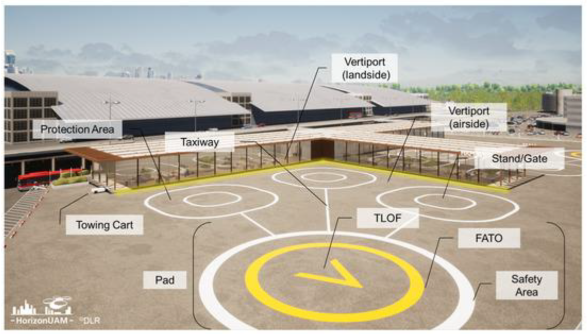
  • Further research is necessary on the performance-based rating of airside operations at future vertiports as well as on the design of vertiport networks in urban environments.
  • Large-scale demonstration of UAM use cases have the potential to booster the maturation of UAM technology and will serve to make the public aware of the possibilities of UAM. For field tests in close-to-reality environments suitable testing sites have to be provided for research and demonstration activities. DLR’s “U-space Regulatory Sandbox” at the commercial airport Magdeburg-Cochstedt, Germany, is planned to become such a test site including a functional U-space airspace in 2026.

Author Contributions

Conceptualization, B.I.S.; writing—original draft preparation, B.I.S., D.G., T.L., F.K., I.C.M., N.P. and K.S.; writing—review and editing, B.I.S.; All authors have read and agreed to the published version of the manuscript.

Funding

This research received no external funding.

Conflicts of Interest

The authors declare no conflict of interest.

Nomenclature

ADS-BAutomatic Dependent Surveillance Broadcast
ATCAir Traffic Control
ATFMAir Traffic Flow Management
ATMAir Traffic Management
ASMAirspace Management
C2Command and Control
CDICourse Deviation Indicator
CISPCommon Information Service Provider
DAADetect and Avoid
DLRDeutsches Zentrum für Luft- und Raumfahrt e.V. (German Aerospace Center)
EASAEuropean Union Aviation Safety Agency
ECEuropean Commission
EUEuropean Union
EGNOSEuropean Geostationary Navigation Overlay Service
eVTOLelectric Vertical Take-Off and Landing
FAAFederal Aviation Administration
FATOFinal Approach and Take-Off
FHSFlying Helicopter Simulator
FLARMFlight Alarm
FMSFlight Management System
FTEFlight Technical Error
GBASGround-Based Augmentation System
GNSSGlobal Navigation Satellite System
HDMHead-Mounted Display
HMDHelmet-Mounted Display
IDFInitial Departure Fix
IFRInstrument Flight Rules
ILSInstrument Landing System
IMCInstrument Meteorological Conditions
LLRLow-Level IFR Routes
LTELong-Term Evolution Broadband Standard
LPVLocalizer Performance with Vertical Guidance
MAPtMissed Approach Point
MLSMicrowave Landing System
NAVNavigation Display
NLRNetherlands Aerospace Centre
PAVPersonal Aerial Vehicle
PFDPrimary Flight Display
PinSPoint-in-Space
RFRadius-to-Fix
RNPRequired Navigation Performance
RWCRemain Well-Clear
SASituational Awareness
SBASSatellite-Based Augmentation System
SNISimultaneous Non-Interfering
SVSSynthetic Vision System
SWCSlot Weight Capacity
TCASTraffic Alert and Collision Avoidance System
UAMUrban Air Mobility
UASUnmanned Aerial System
UAVUnmanned Aerial Vehicle
USSPU-space Service Provider
UTMUnmanned Air Traffic
VFRVisual Flight Rules
VIPVery Important Person
VTOLVertical Take-Off and Landing

References

  1. EASA. Study on the Societal Acceptance of Urban Air Mobility in Europe; EASA: Cologne, Germany, 2021. [Google Scholar]
  2. EASA. Urban Air Mobility (UAM). 2022. Available online: https://www.easa.europa.eu/domains/urban-air-mobility-uam (accessed on 1 September 2022).
  3. Leishman, J.G. Principles of Helicopter Aerodynamics, 2nd ed.; Cambridge Aerospace Series; Cambridge University Press: Cambridge, UK, 2016; ISBN 9781107013353. [Google Scholar]
  4. Brook, R.; Dodge, M. Helicopter Dreaming: The Unrealised Plans for City Centre Heliports in the Post-war Period. In Infrastructure and the Rebuilt City after the Second World War; Working Paper Series no. 22; Birmingham City University: Birmingham, UK, 2014; pp. 42–55. ISBN 978-1-904839-72-9. [Google Scholar]
  5. Bliss, L. The Urban Helicopter Dream Is Rising Again. Bloomberg CityLab, 8 October 2019. Available online: https://www.bloomberg.com/news/articles/2019-10-08/what-s-wrong-with-urban-helicopter-commuting (accessed on 8 November 2021).
  6. Dajani, J.S.; Stortstrom, R.G.; Warner, D.B. The Potential for Helicopter Passenger Service in Major Urban Areas. In NASA-CR-145224, Duke University; 1977. Available online: https://ntrs.nasa.gov/citations/19770020143 (accessed on 8 November 2021).
  7. Monnet, C. Closing This Chapter: Our Learnings on Transforming How People Move. Acubed Airbus, 30 March 2020. Available online: https://acubed.airbus.com/blog/voom/closing-this-chapter-our-learnings-on-transforming-how-people-move/ (accessed on 8 November 2021).
  8. Sheehan, V.; Vertical Flight Society Electric VTOL Directory Hits 700 Concepts. 16 August 2022. Available online: https://vtol.org/news/press-release-vfs-electric-vtol-directory-hits-700-concepts (accessed on 1 September 2022).
  9. Nolan, M.S. Fundamentals of Air Traffic Control; Delmar Cengage Learning: Clifton Park, NY, USA, 2010; ISBN 978-1435482722. [Google Scholar]
  10. Britannica. Air Traffic Control. Available online: www.britannica.com (accessed on 8 November 2021).
  11. European Commision. Air Transport, Study on Potential Benefit to Airport/ATM Congestion Through Special Operation Procedures for Rotorcraft. In Transport Research; European Commision: Luxembourg, 1996; ISBN 92-827-7995-5. [Google Scholar]
  12. Knabe, F. WP D1.2 Capacity Increase Simulation Frankfurt Airport; Deutsche Forschungsanstalt für Luft- und Raumfahrt: Braunschweig, Germany, 1995. [Google Scholar]
  13. Knabe, F.; Dreyzehner, T.; Korn, B. Super Close Runway Operations (SupeRO): A New Concept to Increase Runway Capacity. In Proceedings of the 2022 Integrated Communication, Navigation and Surveillance Conference (ICNS), Dulles, VA, USA, 5–7 April 2022. [Google Scholar] [CrossRef]
  14. Lüken, T.; Korn, B. Helicopter SBAS Guidance for IFR Steep and Curved Approaches. In Proceedings of the International Symposium on Precision Approach and Performance Based Navigation, Bonn, Germany, 14–15 October 2008. [Google Scholar]
  15. ICAO Safety Accident Statistics (2008–2016). Available online: https://www.icao.int/safety/iStars/Pages/Accident-Statistics.aspx (accessed on 1 September 2022).
  16. ICAO. Procedures for Air Navigation Services; Doc 8168-ops/611; ICAO: Montreal, QC, Canada, 2006; Volume 2. [Google Scholar]
  17. Schmerwitz, S.; Dautermann, T.; Lenz, H.; Lüken, T. GNSS Solutions for Increased GA and Rotorcraft Airport Accessibility Demonstration. In Proceedings of the 45th European Rotorcraft Forum (ERF), Warsaw, Poland, 17–19 September 2019. [Google Scholar]
  18. Lüken, T.; Schmerwitz, S.; Halbe, O.; Hamers, M.; Roland, B.; Ganille, T. Flight Evaluation of Advanced SBAS Point-in-space Helicopter Procedures Facilitating IFR Access in Difficult Terrain abd Dense Airspaces. In Proceedings of the 45th European Rotorcraft Forum, Warsaw, Poland, 17–19 September 2019. [Google Scholar]
  19. FAA. Unmanned Aircraft System (UAS) Traffic Management (UTM), Concept of Operations v2.0. NextGEN; FAA: Washington, DC, USA, 2020. [Google Scholar]
  20. SESAR. European Drones Outlook Study, Unlocking the Value for Europe; SESAR Joint Undertaking: Brussels, Belgium, 2016. [Google Scholar]
  21. SESAR. U-Space, Supporting Safe and Secure Drone Operations in Europe, Consolidated Report on SESAR U-Space Research and Innovation Results; Publications Office of the European Union: Luxembourg, 2020. [Google Scholar] [CrossRef]
  22. SESAR3. European ATM Master Plan: Digitalising Europe’s Aviation Infrastructure. Executive View: 2020 Edition; EU Publications Office: Luxembourg, 2020. [Google Scholar]
  23. European Commission, Directorate-General for Research and Innovation. Strategic Research and Innovation Agenda (SRIA) of the European Open Science Cloud (EOSC); Publications Office of the European Union: Luxembourg, 2022. [Google Scholar]
  24. Geister, D.; Korn, B. Concept for Urban Airspace Integration, Integrating UAS into the Future Aviation System. DLR Blueprint. 2017. Available online: https://www.dlr.de/content/de/downloads/2017/blueprint-concept-for-urban-airspace-integration_2933.pdf?__blob=publicationFile&v=11 (accessed on 8 November 2021).
  25. CORUS. U-Space Concept of Operations; Eurocontrol: Brussels, Belgium, 2019. [Google Scholar]
  26. Kuenz, A. City-ATM—Live Drone Trials with Dynamic Geo-fencing. In Proceedings of the 39th AIAA/IEEE Digital Avionics Systems Conference, DASC 2020, Virtual Conference, 11–16 October 2020; ISBN 978-172819825-5. [Google Scholar]
  27. Kuenz, A. City-ATM—Safe Drone Operations in Dense Traffic. In Proceedings of the 40th AIAA/IEEE Digital Avionics Systems Conference, DASC 2021, San Antonio, TX, USA, 3–7 October 2021. [Google Scholar]
  28. Niklaß, M.; Dzikus, N.; Swaid, M.; Berling, J.; Lührs, B.; Lau, A.; Terekov, I.; Gollnick, V. A Collaborative Approach for an Integrated Modeling of Urban Air Transportation Systems. Aerospace 2020, 7, 50. [Google Scholar] [CrossRef]
  29. Törsleff, S.; Kilian, H.F.; Reiswich, E.; Swaid, M.; Grebner, T. Towards a U-space Compliant UTM for Urban Airspaces. In Proceedings of the 27th ITS World Congress, Hamburg, Germany, 11–15 October 2021. [Google Scholar]
  30. EASA. Notice of Proposed Amendment 2021-14: Development of Acceptable Means of Compliance and Guidance Material to Support the U-Space Regulation; EASA Publication Office: Cologne, Germany, 2021. [Google Scholar]
  31. Dauer, J. Automated Low-Altitude Air Delivery; Springer International Publishing: New York, NY, USA, 2022. [Google Scholar] [CrossRef]
  32. Temme, A.; Helm, S. Unmanned Freight Operations. In Proceedings of the Deutscher Luft- und Raumfahrtkongress, DLRK 2016, Braunschweig, Germany, 13–15 September 2016. [Google Scholar]
  33. Geister, R.M.; Peinecke, N.; Sundqvist, B.-G.; del Core, G.; Timmerman, B.; Boer, J.-F.; Zimra, D.; Steinbuch, Y.; Batzdorfer, S.; Grevtsov, N.; et al. On-Board System Concept for Drones in the European U-space. In Proceedings of the Digital Avionics Systems Conference, DASC 2019, San Diego, CA, USA, 8–12 September 2019. [Google Scholar]
  34. Peinecke, N.; Kuenz, A. Deconflicting the Urban Drone Airspace. In Proceedings of the 6th IEEE/AIAA Digital Avionics Systems Conference, DASC 2017, St. Petersburg, FL, USA, 17–21 September 2017; ISBN 978-153860365-9. [Google Scholar]
  35. Peinecke, N.; Limmer, L.; Volkert, A. Application of “Well Clear” to Small Drones. In Proceedings of the Digital Avionics Systems Conference, DASC 2018, London, UK, 23–27 September 2018. [Google Scholar]
  36. Pastor, E.; Filippone, E.; Ferrara, G.; Peinecke, N.; Theunissen, E.; Hagstrom, P.; Taurino, D. URClearED—Defining the Remain Well Clear Concept for Airspace D-G Classes in the European Airspace. In Proceedings of the AIAA Aviation and Aeronautics Forum and Exposition, AIAA AVIATION Forum 2021, Virtual, 2–6 August 2021; ISBN 978-162410610-1. [Google Scholar]
  37. Naser, F.; Peinecke, N.; Schuchardt, B.I. Air Taxis vs. Taxicabs: A Simulation Study on the Efficiency of UAM. In Proceedings of the AIAA Aviation and Aeronautics Forum and Exposition, AIAA AVIATION Forum 2021, Virtual, 2–6 August 2021. [Google Scholar] [CrossRef]
  38. Dahle, O.H.; Rydberg, J.; Dullweber, M.; Peinecke, N.; Bechina, A.A.A. A Proposal for a Common Metric for Drone Traffic Density. In Proceedings of the 2022 International Conference on Unmanned Aircraft Systems (ICUAS), Dubrovnik, Croatia, 21–24 June 2022; pp. 64–72. [Google Scholar] [CrossRef]
  39. Peinecke, N. How to stay well clear in corridors and swarms: Detect-and-avoid ranges for geovectoring concepts. In Proceedings of the 2022 International Conference on Unmanned Aircraft Systems (ICUAS), Dubrovnik, Croatia, 21–24 June 2022; pp. 57–63. [Google Scholar] [CrossRef]
  40. Vertical Flight Society. eVTOL Aircraft Directory. Available online: https://evtol.news/aircraft (accessed on 8 November 2021).
  41. Gartner Inc. Hype Cycle for Emerging Technologies. 2019. Available online: www.gartner.com/smarterwithgartner (accessed on 1 January 2020).
  42. Straubinger, A.; Rothfeld, R.; Shamiyeh, M.; Büchter, K.-D.; Kaiser, J.; Plötner, K.O. An Overview of Current Research and Developments in Urban Air Mobility—Setting the Scene for UAM Introduction. J. Air Transp. Manag. 2020, 87, 101852. [Google Scholar] [CrossRef]
  43. Nieuwenhuizen, F.M.; Jump, M.; Perfect, P.; White, M.D.; Padfield, G.D.; Floreano, D.; Schill, F.; Zufferey, J.-C.; Fua, P.; Bouabdallah, S.; et al. myCopter—Enabling Technologies for Personal Aerial Transportation Systems. In Proceedings of the 3rd International HELI World Conference, Frankfurt/Main, Germany, 2–4 November 2011. [Google Scholar]
  44. Schuchardt, B.I. Workload Reduction through Steering Wheel Control for Rotorcraft. CEAS Aeronaut. J. 2019, 10, 893–902. [Google Scholar] [CrossRef]
  45. Nieuwenhuizen, F.M.; Bülthoff, H.H. Evaluation of Haptic Shared Control and a Highway-in-the-Sky Display for Personal Aerial Vehicles. In Proceedings of the AIAA Modeling and Simulation Technologies Conference, AIAA, Atlanta, GA, USA, 16–20 June 2014; pp. 1–9. [Google Scholar]
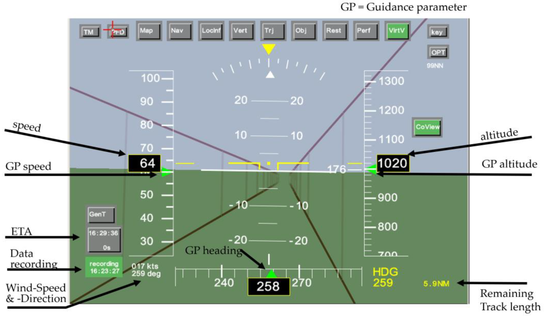
  46. Gursky, B.I.; Olsman, W.F.J.; Peinecke, N. Development of a Tunnel-in-the-Sky Display for Helicopter Noise Abatement Procedures. CEAS Aeronaut. J. 2014, 5, 199–208. [Google Scholar] [CrossRef]
  47. Achtelik, M.W.; Lynen, S.; Weiss, S.; Chli, M.; Siegwart, R. Motion and Uncertainty-Aware Path Planning for Micro Aerial Vehicles. J. Field Robot. 2014, 31, 676–698. [Google Scholar] [CrossRef]
  48. Sun, X.; Christoudias, C.M.; Lepetit, V.; Fua, P. Real-time Landing Place Assessment in Man-made Environments. Mach. Vis. Appl. 2014, 25, 211–227. [Google Scholar] [CrossRef] [Green Version]
  49. Sunil, E.; Hoekstra, J.; Ellerbroek, J.; Bussink, F.; Nieuwenhuisen, D.; Vidosavljevic, A.; Kern, S. Metropolis: Relating Airspace Structure and Capacity for Extreme Traffic Densities. In Proceedings of the USA/Europe Air Traffic Management Research and Development Seminars, Lissabon, Portugal, 23–26 June 2015. [Google Scholar]
  50. Schneider, O.; Kern, S.; Knabe, F.; Gerdes, I.; Delahaye, D.; Vidosavljevic, A.; van Leeuwen, P.; Nieuwenhuisen, D.; Sunil, E.; Hoekstra, J.; et al. Metropolis Urban Airspace Design. Metropolis Project Deliverable Concept Design D2.2, ACP3-GA-2013-34 2014. Available online: https://homepage.tudelft.nl/7p97s/Metropolis/downloads/Metropolis_D2-2_Concept_Design_Report_v10.pdf (accessed on 1 September 2022).
  51. Leipold, A.; Aptsiauri, G.; Ayazkhani, A.; Bauder, U.; Becker, R.-G.; Berghof, R.; Claßen, A.; Dadashi, A.; Dahlmann, K.; Dzikus, N.; et al. DEPA 2050—Development Pathways for Aviation up to 2050; Final Report, DLR IB; German Aerospace Center: Cologne, Germany, 2021. [Google Scholar]
  52. Schuchardt, B.I.; Becker, D.; Becker, R.-G.; End, A.; Gerz, T.; Meller, F.; Metz, I.C.; Niklaß, M.; Pak, H.; Prakasha, S.P.; et al. Urban Air Mobility Research at the DLR German Aerospace Center—Getting the HorizonUAM Project Started. In Proceedings of the AIAA Aviation 2021 Forum, Virtual, 2–6 August 2021. [Google Scholar] [CrossRef]
  53. Cohen, A.P.; Shaheen, S.A.; Farrar, E.M. Urban Air Mobility: History, Ecosystem, Market Potential, and Challenges. IEEE Trans. Intell. Transp. Syst. 2021, 22, 6074–6087. [Google Scholar] [CrossRef]
  54. Airservices Australia and Embraer Business Innovation Center. Urban Air Traffic Management Concept of Operations, Version 1; Airservices Australia and Embraer Business Innovation Center: Canberra, Australia, 2020. [Google Scholar]
  55. Vascik, P.D.; Hansman, R.J. Scaling Constraints for Urban Air Mobility Operations: Air Traffic Control, Ground Infrastructure, and Noise. In Proceedings of the Aviation Technology, Integration, and Operations Conference, Atlanta, GA, USA, 25–29 June 2018. [Google Scholar]
  56. Panchal, I.; Metz, I.C.; Ribeiro, M.; Armanini, S.F. Urban Air Traffic Management for Collision Avoidance with Non-Cooperative Airspace Users. In Proceedings of the 33rd Congress of the International Council of the Aeronautical Sciences, Stockholm, Sweden, 4–9 September 2022. [Google Scholar]
  57. Ahrenhold, N.; Pohling, O.; Schier, S. Impact of Air Taxis on Air Traffic in the Vicinity of Airports. Infrastructures 2021, 6, 140. [Google Scholar] [CrossRef]
  58. Metz, I.C.; Schier-Morgenthal, S. An Operational Concept for the Integration of Urban Air Traffic Mobility Vehicles into the Air Traffic Control Processes. In Proceedings of the 33rd Congress of the International Council of the Aeronautical Sciences, Stockholm, Sweden, 4–9 September 2022. [Google Scholar]
  59. Bundesministerium der Justiz. Luftverkehrsgesetz, Version of 10 May 2007; Bundesministerium der Justiz: Berlin, Germany, 1922. [Google Scholar]
  60. Schweiger, K.; Preis, L. Urban Air Mobility: Systematic Review of Scientific Publications and Regulations for Vertiport Design and Operations. Drones 2022, 6, 179. [Google Scholar] [CrossRef]
  61. Schweiger, K.; Knabe, F.; Korn, B. An Exemplary Definition of a Vertidrome’s Airside Concept of Operations. Aerosp. Sci. Technol. 2021, 125, 107144. [Google Scholar] [CrossRef]
  62. Schweiger, K.; Knabe, F.; Korn, B. Urban Air Mobility: Vertidrome Airside Level of Service Concept. In Proceedings of the AIAA Aviation 2021 Forum, Virtual, 2–6 August 2021. [Google Scholar] [CrossRef]
  63. Wendt, K.; König, A.; Naser, F. Development of a Modular Model City for Unmanned Aircraft Vehicle Experiments—A Visionary Concept. In Proceedings of the AIAA Aviation 2022 Forum, Chicago, IL, USA, 27 June–1 July 2022. [Google Scholar] [CrossRef]
  64. Anon. Uspace4UAM Press Release 1. 2021. Available online: https://www.dlr.de/fl/PortalData/14/Resources/dokumente/Uspace4UAM_press_release_1.pdf (accessed on 12 December 2022).
  65. Anon. Air Mobility Urban—Large Experimental Demonstrations. Available online: https://amuledproject.eu/, (accessed on 12 December 2022).
  66. Xu, Y.; Su, Y.; Fremond, R.; Tang, Y.; Uzun, M.; Hasanzade, M.; Bhundoo, P.; Inalhan, G.; Murphy, D.; Oreg, Z.; et al. Platform, Missions and Performance Assessment Report and U-space System Models. AMU-LED D3.2, December 2021. Available online: https://amuledproject.eu/deliverables/ (accessed on 1 December 2022).
  67. SESAR. Sustainability, Airspace Optimisation and Urban Air Mobility—Focus of Latest Very Large-scale Demonstrations. Available online: https://www.sesarju.eu/news/sustainability-airspace-optimisation-and-urban-air-mobility-focus-latest-very-large-scale (accessed on 12 December 2022).
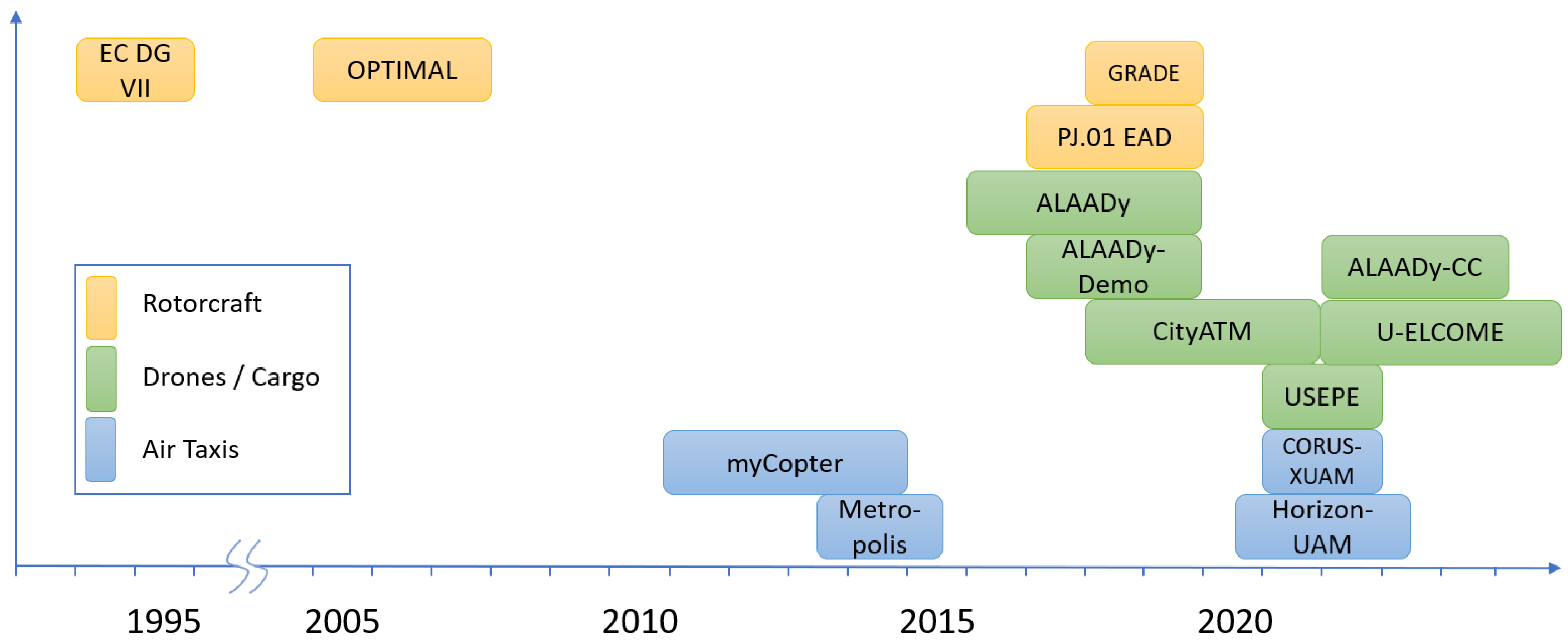
Figure 1. Timeline of projects included in this review.
Aerospace 10 00081 g001
Figure 2. Tunnel−in−the−sky display (dark purple lines) and overlaid Bug-PFD-guidance display.
Aerospace 10 00081 g002
Figure 3. Primary flight display with course deviation indicator.
Aerospace 10 00081 g003
Figure 4. Synthetic vision system with tunnel-in-the-sky display.
Aerospace 10 00081 g004
Figure 5. Shared traffic awareness concept in ALAADy.
Aerospace 10 00081 g005
Figure 6. Performance−based safety volume for DAA (detect-and-avoid).
Aerospace 10 00081 g006
Figure 7. Possible configurations for a large cargo drone.
Aerospace 10 00081 g007
Figure 8. Cargo drone prototype build in ALAADy-Demo.
Aerospace 10 00081 g008
Figure 9. Steering wheel control for a personal aerial vehicle [44].
Aerospace 10 00081 g009
Figure 10. Highway-in-the sky concept as navigation assistance for minimally trained pilots [46].
Aerospace 10 00081 g010
Figure 11. Metropolis airspace concepts Layers, Tubes, Zones and Full Mix [50].
Aerospace 10 00081 g011
Figure 12. Exemplary UAM vertiport layout [60].
Aerospace 10 00081 g012
Table 1. Overview of key projects.
ProjectTopicYearsPartnersKey Outcome
EC DG VIIStudy on potential benefit to airport/ATM congestion through special operational procedures for rotorcraft1994–1995Eurocopter, Agusta Westland, DFS Deutsche Flugsicherung Gmbh, Aeroport de Paris, TU Braunschweig, DLRScenario development, procedure design and capacity assessment for fixed-wing replacement by rotorcraft and tiltrotor at hub airports
OPTIMALOptimized Procedures and Techniques for IMprovement of Approach and Landing2005–2007DLR, INECO, AIRBUS, THALES ATM, ISDEFE, NLR, AENA, EUROCONTROL, THALES Avionics, AGUSTA, DFS, LVNL, ENAV, SICTADefinition and validation of innovative procedures for the approach and landing phases of aircraft and rotorcraft in a pre-operational environment
GRADEIncreased General Aviation and Rotorcraft operations supported by GNSS solutions2018–2019CIRA, BULATSA, DLR, MATS, NAIS, TUBS, UNIPARTH, ISSNOVADemonstration of Standard Point-In-Space (PinS) helicopter procedures as well as low-level IFR routes (LLR) for helicopters
PJ.01 EADEnhanced Arrival and Departures2017–2019Airbus Helicopters, Thales Avionics, DLRValidation of Advanced PinS helicopter procedures supported by SVS und HMD systems
CityATMDemonstration of Traffic Management in Urban Airspace2018–2021DLR (5 institutes/facilities), in cooperation with NXP, FlyNex GmbH, DFS Deutsche Flugsicherung GmbH, Auterion AG, Zentrum für Angewandte Luftfahrtforschung GmbH, KopterKraftU-space Demonstration Platform with focus on density-based airspace and traffic management
USEPEU-space Separation in Europe2021–2022ISDEFE, Nommon, Universitetet i Sørøst-Norge, DLR, Leibniz Universität Hannover, POLIS, Indra Navia ASConcept and simulation of an advanced separation and traffic management for an urban drone airspace.
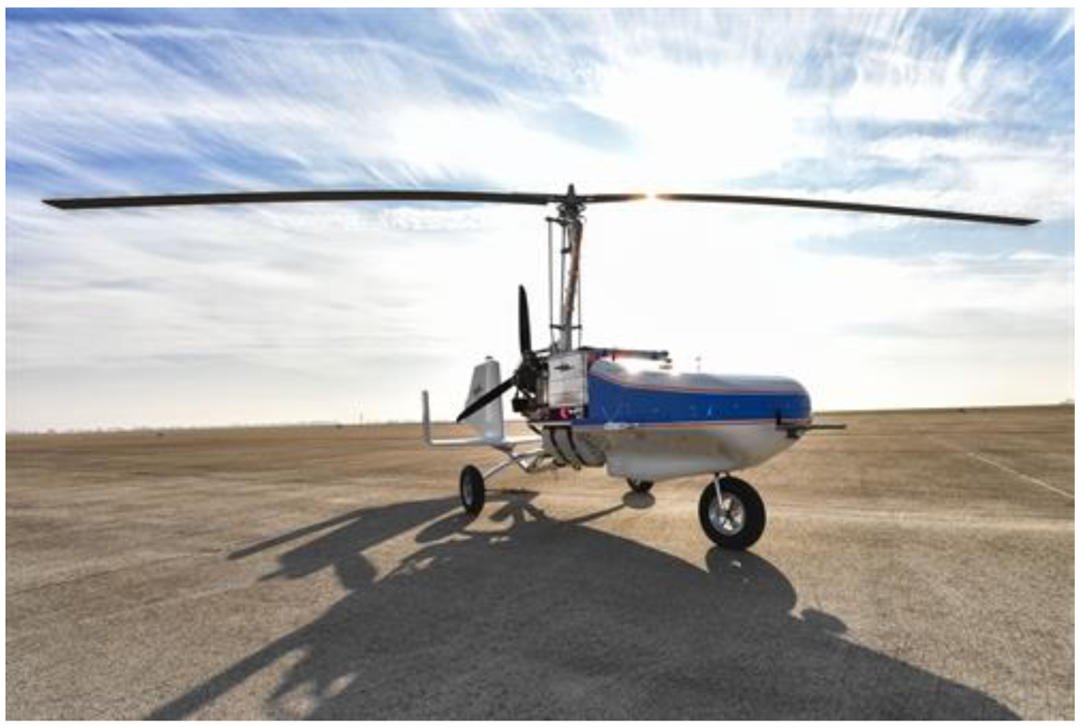
ALAADyAutomated Low Altitude Air Delivery2016–2019DLR (7 institutes/facilities)Concept and feasibility study for the operation of a large cargo drone in lower airspace.
ALAADy-DemoALAADy Demonstrator2016–2019DLR (3 institutes/facilities)Realization of several technical prototypes for a rotary wing (gyrocopter) cargo drone.
ALAADy-CCCross Country Air Delivery2022–2024DLR (6 institutes/facilities)Realization of an actual test-flight operation of a gyrocopter cargo drone.
U-ELCOMEU-space European COMmon dEpLoyment2022–2025EUROCONTROL, DLR, ENAV, ENAIRE, Thales, Airbus, CRIDA, EUROUSC, CIRA, Honeywell (51 partners)Implementation of a common framework and understanding for the deployment of U-space ConOps.
myCopterEnabling Technologies for Personal Aerial Transportation Systems2011–2014MPI for Biological Cybernetics, UoL, EPFL, ETHZ, KIT, DLRControl concepts for PAV demonstrated in ground-based and in-flight simulations, human-machine interfaces, computer-vision-based automation, collision avoidance, automatic landing place detection and societal impact assessment
MetropolisRelating Airspace Structure and Capacity for Extreme Traffic Densities2013–2015TU Delft, DLR, ENAC, NLRDevelopment and assessment of airspace concepts for high-density UAM operations
CORUS-XUAMConcept of Operations for European U-space Services—Extension for Urban Air Mobility2020–2022Eurocontrol, ADP, Aslogic, The British Light Aviation Centre Limited, DFS, DLR, Droniq, DSNA, ENAIRE, ENAV, Hemav Foundation, INDRA, Swedish Civil Aviation Administration, NATS, Pipistrel, SkeyDrone, UNIFLY, UPC, VolocopterUpdated U-space ConOps including Urban Air Mobility operations
HorizonUAMUrban Air Mobility Research at the German Aerospace Center (DLR)2020–2023DLR (11 institutes/facilities)Assessment of chances and risks of urban air mobility concepts regarding vehicle, infrastructure, operation and public acceptance
Disclaimer/Publisher’s Note: The statements, opinions and data contained in all publications are solely those of the individual author(s) and contributor(s) and not of MDPI and/or the editor(s). MDPI and/or the editor(s) disclaim responsibility for any injury to people or property resulting from any ideas, methods, instructions or products referred to in the content.

