Article

Application of Scenario Forecasting Methods and Fuzzy Multi-Criteria Modeling in Substantiation of Urban Area Development Strategies

1
Department of Digital Technologies for Urban Studies, Architecture and Civil Engineering, Volgograd State Technical University, 1 Akademicheskaya Str., 400074 Volgograd, Russia
2
Department of Building Structures, Foundations and Reliability of Constructions, Volgograd State Technical University, 1 Akademicheskaya Str., 400074 Volgograd, Russia
*
Author to whom correspondence should be addressed.
Information 2023, 14(4), 241; https://doi.org/10.3390/info14040241
Submission received: 15 February 2023 / Revised: 6 April 2023 / Accepted: 11 April 2023 / Published: 14 April 2023
(This article belongs to the Special Issue New Applications in Multiple Criteria Decision Analysis II)

Abstract

:
The existing approaches to supporting the tasks of managing the urban areas development are aimed at choosing an alternative from a set of ready-made solutions. Little attention is paid to the procedure for the formation and analysis of acceptable options for the use of territories. The study's purpose is to understand how various factors affect the efficiency of using the city’s territory. In addition, we are trying to use this understanding to assess the possible consequences of the implementation of management decisions on the territory transformation. We use the method of structuring knowledge about the study area, taking into account the influence of the external environment. This method implements the significant factors list formation and assessment of their impact on development. Fuzzy cognitive modeling was used to build scenarios for identifying contradictions in achieving sustainable development goals. The scenario modeling results are necessary for the formation of the alternative. Alternatives are evaluated on the basis of fuzzy multi-criteria optimization. The integration of methods makes it possible to increase the objectivity of the analysis of strategies for urban areas development. The Belman-Zadeh method is used to analyze the selected options based on criteria that determine the feasibility and effectiveness of each project.

1. Introduction

Creating a sustainable future depends on good governance and the development of science-based urban development policies. The practice of urban planning has a lot of experience. However, there are a significant number of tasks that cause significant difficulties in the solution process. First of all, there are the tasks of coordinating the goals of stakeholders. There are also the tasks of identifying the most significant factors that affect the efficiency of using a particular territory [1].
The urban area is a resource. On the one hand, the disposal of this resource makes it possible for the city as a subject of a competitive environment to receive profits and preferences in case of its effective use. On the other hand, the urban area is the basis for the existence and functioning of the urban community. The main goal of the functioning of the city is to meet the needs of urban residents in quality housing, social facilities, transport, engineering infrastructure, and other life support systems.
The structure and appearance of cities are constantly changing. New activities and uses of the urban area are emerging. Public spaces and recreational areas are becoming increasingly important. Attitudes towards existing buildings have changed significantly in recent years. The practice of rehabilitation and adaptation of old buildings and structures is being actively introduced. This makes it possible to increase the efficiency of urban land use and make the city more attractive for living.
The problem of restructuring urban spaces is becoming increasingly relevant. The works of Randall F. Mason, Donovan R. Rypkema, and Caroline Cheong provide the most comprehensive review of studies analyzing approaches to the use and conversion of built-up areas, as well as to the economic aspects of the historical buildings’ preservation [2,3].
Various options for reusing existing buildings are considered in many works. Studies [4,5,6] analyze various renovation options that contribute to social and economic improvements. Methods for organizing activities to coordinate various interests when choosing options for the development of territories are considered in [7,8].
Methods based on the analysis of basic costs and benefits, mathematical modeling, and statistical analysis are of particular importance at the moment. These methods can be used to determine the return on investment in a city development project [6,8].
Works [9,10,11,12,13] study the sustainable development of urban areas. The approaches are based on the modeling of urban development from the position of a person’s perception of the physical environment of the city and the satisfaction of its basic needs, as well as external influences (political, economic, social, etc.).
The following aspects can be noted based on the results of the implementation of programs for the transformation of territories in various cities of the world [14,15,16]:
  • Renovation of urban space is a complex process aimed at enhancing economic activity, increasing sustainability, and creating new competitive advantages for the city;
  • The interests of various parties, primarily residents and potential investors, must be coordinated when implementing projects to transform territories;
  • The process of interaction with the owners of obsolete objects located in the territory of redevelopment is carried out by buying out real estate objects at a certain market value. Or the owner is involved in the implementation of the project along with external investors who are attracted by the city authorities;
  • Minimization of risks and negative effects in the implementation of adaptive management programs for the development of territories is possible by taking into account the comprehensive impact of the project: on the local budget, on changes in real estate prices, on the level of investment and unemployment at the project development stage. Monitoring of the implementation of the relevant project may also be carried out subsequently. This will allow us to make timely adjustments if necessary.
Support for decision-making on the management of changes in urban areas should be based on a consistent analysis of the existing situation and a reasonable choice of development options. At the same time, uncertainties and long-term forecasts must be taken into account. This will help avoid negative consequences.
Various modeling methods and technologies are used in decision support systems in the field of urban planning and sustainable development of cities. For example, factor analysis methods are used in [17] to assess the prospects for the demolition of buildings for sustainable renovation. Data on economic, social, environmental, and institutional aspects of sustainable development have become the subject of analysis. Both individual characteristics of buildings and external indicators at the district, local, or city level are taken into account.
Multi-criteria evaluation methods are actively used in planning and urban development problems. The study [18] highlights the complexity of decision-making in the process of urban transformation. The authors describe a process for evaluating options for Sustainable Urban Regeneration of Historic Urban Quarters based on the analytical hierarchy process (AHP). Particular attention is paid to the harmonization of social and economic criteria.
A preliminary decision model for evaluating the sustainability of urban renewal projects based on hybrid multi-attribute decision-making (MADM) is presented in [19]. It is shown how various indicators affect the effectiveness of decisions made.
An approach based on the integration of machine learning methods (spatial identification of the territory) and methods of multi-criteria optimization are studied in the article [20]. The authors propose a conceptual framework based on complex urban ecosystems, combining ecological and socio-economic subsystems to assess the most appropriate land use directions under different brownfield redevelopment objectives. The AHP method was used to evaluate redevelopment options. This once again confirms that the integration of various methods allows for an increase in the validity of the analysis. Thus, work [21] combines various techniques, such as stakeholder engagement, SWOT analysis, and the ANP-BOCR method. The authors argue that this made it possible to obtain an objective and reliable result in the analysis of options for the transformation of the port area on the canal of Rimini, Italy.
The choice of decision support methods, as well as tools for their implementation, is still a difficult task. Therefore, reviews of decision-making methods for solving urban planning problems make it possible to justify the choice of methods [22,23]. Constructive proposals for collaborative decision-making in urban regeneration in terms of policy formulation, stakeholder coordination, and development of decision support tools are presented in [24] based on an analysis of 160 journal articles.
It should be emphasized that most studies focus on the process of choosing an alternative from a set of ready-made solutions. However, the process of forming acceptable options most often turns out to be the most difficult in urban planning tasks. An integrated framework is proposed in [25] that combines stakeholder analysis, STEEP plus SWOT analysis, scenario building, and a multi-criteria decision analysis approach (MCDA). Such an integrated approach is applied in the analysis of future scenarios for an underdeveloped area in Northern Italy. However, the mutual influence of various factors is not taken into account in this case.
The process of urban evolution is also studied on the basis of statistical approaches. It includes model selection, variable fitting, spatial autocorrelation, and scaling to comprehensively study the development of urban evolution [26]. The use of the GIS approach allows stakeholders to be involved in the joint development and interpretation of urban space through dynamic geovisualization and modeling [27].
Modeling urban land use change can come in relatively diverse forms in terms of layout, building density, and rate of change. Today, the global measurement of changes in land use associated with urbanization is a topical issue for the urbanized areas development [28,29].
The analysis of existing approaches to solving the problems of choosing options for the development of urban areas showed that most of them use methods with the following disadvantages:
  • There is no mechanism for agreeing on the development goals of the territory;
  • There is no mechanism for taking into account the mutual influence of factors and cumulative effects;
  • The uncertainty factor of the initial information is not always taken into account when forming criteria for evaluating alternatives.
The choice problem considered in this study is characterized by a high level of uncertainty. In this case, it is difficult to specify the specific value of the target indicators. Methods based on knowledge representation models are necessary in order to understand which alternatives correspond to these directions of desirable development, and to identify contradictions and problems of the situation under study. In this regard, it is proposed to use a cognitive approach that will make it possible to form a list of significant environmental factors and assess the impact of these factors on the development of the situation under study. This will significantly improve the stage of preliminary analysis of the problem being solved.
This technology is able to identify a number of scenarios that describe alternative futures and assess the possibility of improving the situation [30,31,32]. Works [33,34] present the results of applying the scenario approach to the analysis of sustainable urban development.
The possibilities of integrating cognitive modeling with decision-making methods are shown in the framework of this study. This creates the basis for the analysis of possible impacts on the future states of the analyzed system.
This document is structured as follows. This section reveals the relevance and background of the work and contains a review of the literature on the application of Scenario Forecasting Methods and Fuzzy Multi-Criteria Modeling, as well as various approaches to the transformation of the city and the selection of projects for the development of these territories. Section 2 describes the proposed approach to decision support in substantiating urban development strategies. The section contains a description of the procedure for constructing a cognitive map and a presentation of the model for ranking projects for the development of the territory. The rationale for the choice of the assessment method is given additionally. Section 3 contains the results of applying the proposed approach to the analysis of the use of the territory of a particular settlement (the city of Pallasovka, Volgograd region, Russia). The description is made to build simulation scenarios using FCM and calculate the evaluation of development options. Section 4 analyzes the results of the conducted studies in comparison with existing studies in this and related areas of application of MCDM, as well as the advantages of the proposed approach. Section 5 formulates general conclusions, summarizes the results, and outlines the prospects for the study.

2. Materials and Methods

Activities for managing the development of urban areas should be based on information related to the need to solve a number of analytical tasks:
  • Analysis of the effectiveness of the use of territorial and natural resources;
  • Analysis of options for the use of territories;
  • Analysis of investment activity;
  • Analysis of the dynamics of construction and reconstruction of housing;
  • Analysis of the effectiveness of the functioning of transport, engineering, and social infrastructure;
  • Analysis of the environmental situation.
This study aims to form an approach to support decision-making on the transformation of the city. The proposed approach includes a number of stages presented in Figure 1. The approach implements all the necessary procedures that are defined by state regulations when planning activities for integrated area development (the example of the legal framework of the Russian Federation is used).

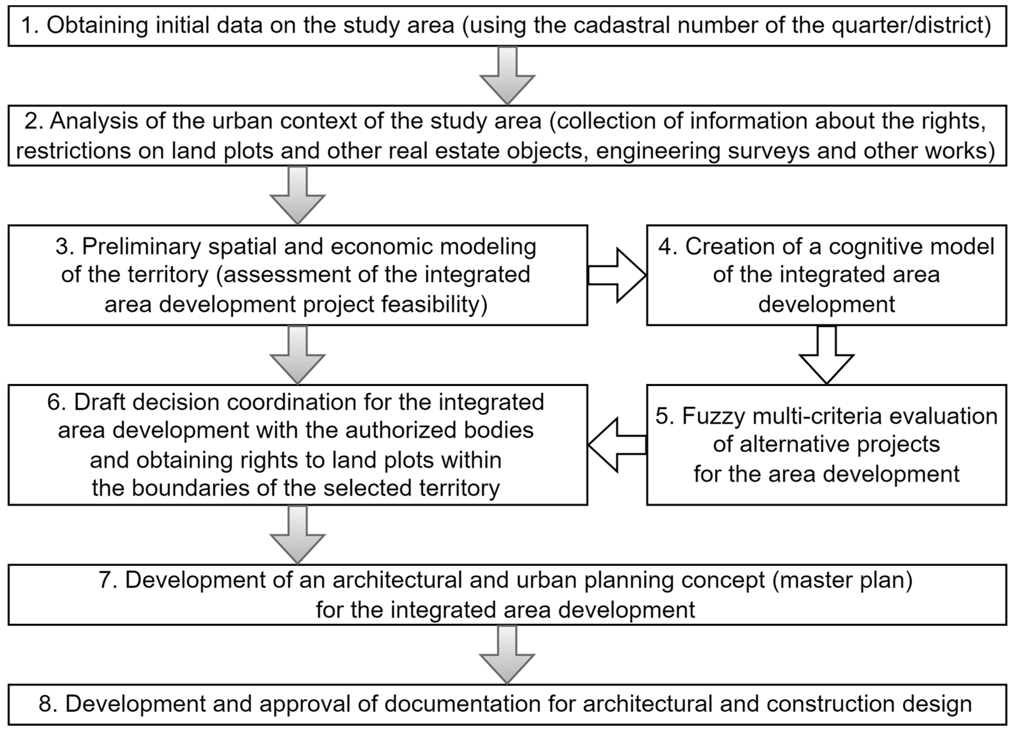
2.1. Stage 1. Obtaining Initial Data on the Study Area

The collection of information about the study area is carried out from various sources in the first stage. This information is usually contained in a public cadastral map or other sources associated with land use registration.

2.2. Stage 2. Analysis of the Urban Context of the Study Area

This stage includes the collection of information about the legal status of land and property complexes that are part of the study area. This information is contained in the database of the state register of real estate. Information on the composition of engineering and geological surveys of the territory under consideration and assessment of the technical characteristics of buildings and structures on the territory are additionally specified from the survey technical reports.
The level of uncertainty of the processes under study must be analyzed when studying the functioning and development of such a complex system as an urbanized area. It is necessary to identify the factors that determine the development of the situation and understand which of them can be assessed on the basis of statistical information, and which on the basis of an expert survey.
Table 1 shows the types and sources of information used in solving problems of territorial development.

2.3. Stage 3. Preliminary Spatial and Economic Modeling of the Territory

This stage includes a preliminary spatial and economic justification of the project. The stage is aimed at assessing the investment attractiveness of the territory for the implementation of the project, taking into account urban planning and economic restrictions. The financial and economic justification of the architectural and urban planning concept of the proposed development of the territory is also being carried out.
The collection of information about the real estate market of the territory under consideration and the population is carried out as part of this stage. The balance of the territory is drawn up.
The balance of the territory includes a description of the total area of residential and commercial buildings, the area of the territory occupied by social infrastructure facilities (schools, kindergartens, clinics, hospitals, etc.), the area of the public territory, including the road network, squares, parks, etc. The generated balance shows the structure of the functional use of the territory based on the total area of real estate objects located on it. The spatial model of the area is formed using OpenStreetMap, QGIS, AutoCAD, or other GIS.

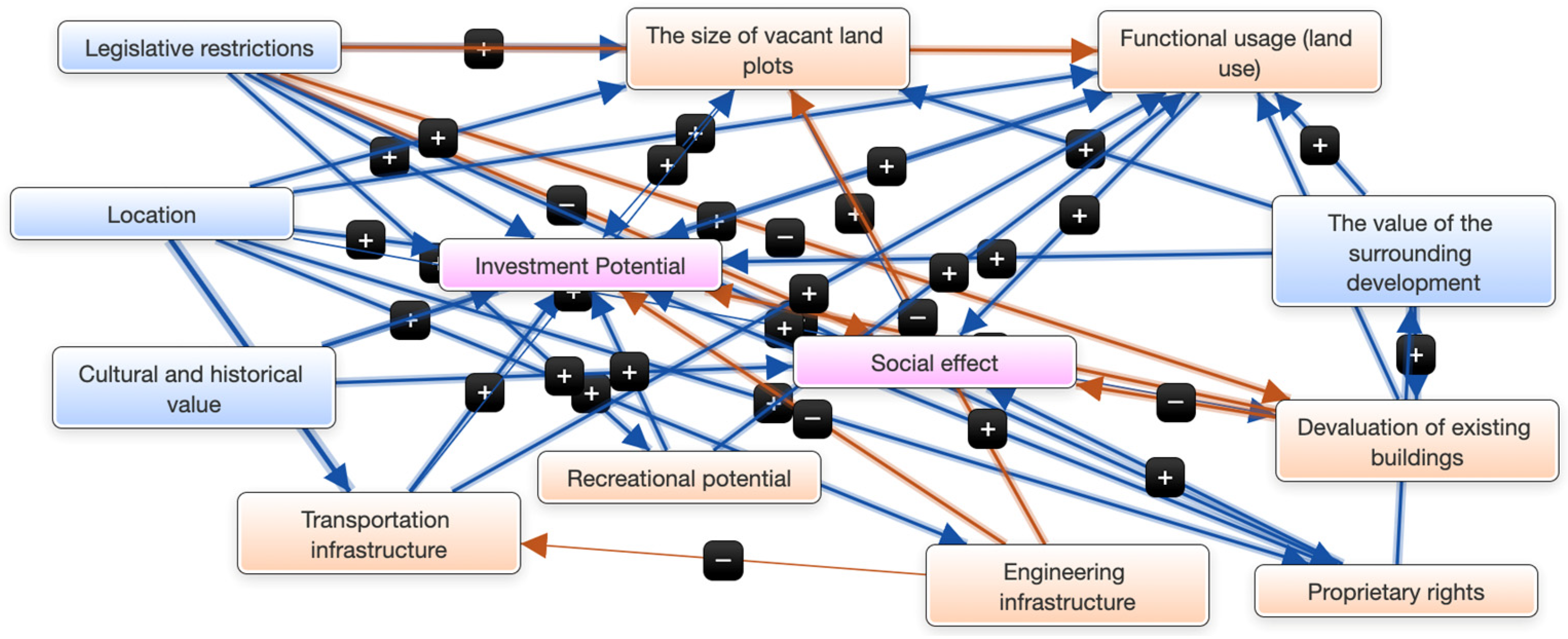
2.4. Stage 4. Creation of a Cognitive Model of the Integrated Area Development

The next stage is an addition to the standard decision selection procedures and implements scenario forecasting based on a fuzzy cognitive model (FCM). This approach has shown its effectiveness in a variety of subject areas [35,36,37,38,39,40,41].
The methodology of cognitive modeling is focused on working with expert knowledge. It provides the necessary tools for identifying, analyzing, and coordinating the views that characterize the opinions and views of those involved in the management process.
The construction of the model is based on the study of the interests of all stakeholders. Therefore, the effect achieved from the implementation of the project may have:
  • Financial expression—increase in income from taxes, business, etc.;
  • Non-financial expression—increase in the value of city assets (infrastructure and real estate), improving the quality of life of the population, increasing the competitiveness of the city, etc.).
The factors included in the model reflect the urban context and urban morphology of the territory under consideration. They make it possible to analyze various aspects of the development of the situation, taking into account the identified interrelations, and to assess the consequences of the decisions made.
Classical forecasting methods focus on assessing the most probable variant of the system development. Uncertainty and ambiguity of the trajectory of this development are the initial prerequisites for scenario forecasting.
Scenario forecasting makes it possible to simultaneously consider several options for the development of a situation and analyze opportunities and risks. The scenario approach does not specify a specific set of actions for creating a forecast but defines a set of various techniques and mechanisms that allow synthesizing scenarios. One of the main tasks of scenario forecasting is to detect such factors from among those inherent in current conditions and situations that will allow the creation of a mechanism for influencing the future states of the system.
Expert knowledge is needed to determine the factors of the model. The experts should have an understanding of the environmental, social, economic, and technological aspects associated with the development of the area under consideration. In addition, information is used from open sources, which contain data on the study area.
The factors presented in Table 2 were determined to solve the problem of analyzing scenarios for territory development. The list of presented factors is based on the trinity of categories of real estate: physical (material), legal and economic, as the main component of the urban area. The factors highlighted in each category create a comprehensive view of the object of study and allow an all-around assessment of possible future transformations.
It is necessary to determine the relationship between factors and establish the direction of influence to build a cognitive model. FCM is a parameterized form of concept mapping. Qualitative static models can be developed with their help. Further, they can be transformed into semi-quantitative dynamic models.
Such maps are a relatively easy-to-use form of semi-quantitative modeling. They are used in a wide variety of fields to understand the behavior of complex systems. FCM represents knowledge and defines the components of the system (factors), the positive or negative relationships between them, and the degree of influence of one factor on another. The developed model in the form of a cognitive map is shown in Figure 2. For example, the influence of the “Engineering Infrastructure” factor on “Investment Potential” is positive, i.e., an increase in the quality of engineering infrastructure will lead to an increase in investment potential.
The constructed map is used to model the behavior of a complex system where uncertainty is high and there is little empirical data. In this case, it is used to analyze options for the development of local territories of small towns. It is necessary to build possible development scenarios and evaluate the values of target factors for this analysis. “Social Effect” and “Investment Potential” are the target factors in this case.
Scenario modeling allows us to consider the dynamics of the development of the situation, both in the presence of control actions and in their absence. On the other hand, scenarios are necessary to analyze the risks that may be the result of erroneous decisions or unfavorable developments.

2.5. Stage 5. Fuzzy Multi-Criteria Evaluation of Alternative Projects for the Area Development

The results of scenario forecasting are used to form alternatives that meet the strategic goals of the territory’s development. Further, suitable investment projects are proposed to be evaluated using the fuzzy optimization method.
Accuracy and practical meaning become almost exclusive concepts for real situations in economic, social, and other systems, the complexity of which exceeds a certain threshold level. Therefore, it is necessary to take into account uncertainty when evaluating options in decision-making.
The use of probabilistic models leads to the fact that uncertainty is identified with randomness. At the same time, fuzziness is a major source of uncertainty in many decision-making processes [42,43,44].
The theory of fuzzy sets was first proposed by the American mathematician Lotfi Zadeh. It is used to overcome the difficulties of representing imprecise concepts and analyzing and modeling complex systems.
A fuzzy set is a set of ordered pairs of the form < x , μ A x > , where x is an element of some universal set X, and μ A x is a membership function that associates each element x with some real number from the interval [0, 1], i.e., defines the mapping [45]:
μ A : X [ 0 , 1 ]
The value μ A x = 1 means that element x definitely belongs to the fuzzy set A. The value μ A x = 0 means that the element x definitely does not belong to the fuzzy set A.
The Bellman-Zadeh principle is widely used in decision-making models under uncertainty [41]. A modification of this method [46] allows the use of paired comparisons to evaluate alternatives. It is based on the following points:
  • Interpretation of the criteria as fuzzy sets defined on universes of the discourse of variants by membership functions;
  • Determination of the membership functions of the fuzzy sets on the basis of expert information about paired comparisons of variants by the 9-point Saaty scale [47];
  • Ranking of variants on the basis of intersections of fuzzy sets, criteria that correspond to the Bellman–Zadeh scheme known in decision theory;
  • Ranking of criteria by the method of paired comparisons and interpretation of the ranks obtained as the degree of concentration of the corresponding membership functions.
Let there be a set of k alternative projects:
X = {x1; x2; … xk}.
A comparative analysis of the presented projects can be carried out according to the following set of quantitative and qualitative criteria:
G = {G1; G2; … Gn}.
Then the fuzzy set can be considered for the criterion G:
G = [ μ G 1 ( x 1 ) x 1 , μ G 2 ( x 2 ) x 2 , , μ G i ( x k ) x k ]
where μ G i x j [ 0 , 1 ] —evaluation of the alternative project xj according to the criterion Gi characterizes the degree of compliance of the alternative with the concept defined by the criterion G.
If there are n criteria G1; G2; … Gn, then the best alternative is considered to satisfy both the criteria G1, and G2, and …, and Gn. Then the rule for choosing the best alternative can be written as the intersection of the corresponding fuzzy sets:
D = G 1 G 2 , , G n .
The operation of intersection of fuzzy sets corresponds to the operation min, performed on their membership functions:
μ x j = min i = 1 , n μ G i x j
The most efficient design option should have the highest x* membership function value:
μ x * = max j = 1 , k μ G i x j
The task of the study is to select the best project for the transformation of the territory based on the analysis of economic, social, technical and environmental criteria. At the same time, it is necessary to take into account the complex nature of the interrelationships of these criteria based on existing state standards and norms.
Each of the projects has its own specific characteristics, which are determined by the requirements for construction and further operation (requirements for lighting, maintenance of engineering systems of the facility, planting of greenery, availability of parking spaces, etc.). Despite this, criteria common to alternative projects have been proposed. These criteria characterize the feasibility and effectiveness of the implementation of the projects under consideration.
In this regard, the following criteria have been defined:
G1—the uniqueness of the object in the segment of the market under study (the level of competition among market participants)—this criterion distinguishes an object (planned for implementation) among identical objects (existing) related to this market segment (the specific feature of the object being created will primarily come from the uniqueness of its location, the presence of such objects in this segment, as well as its functional features, that were previously uncharacteristic of other objects);
G2—social significance (the degree of the project’s contribution to the solution of strategic tasks for the development of the territory)—the project being created should take into account the current needs of the population in the social sphere, help improve the quality of the urban environment and preserve the population in the territory under consideration;
G3—project payback period—this criterion determines the time interval that runs from the moment the project idea is created to the receipt of revenue covering the investment costs of its creation;
G4—budgetary efficiency (return on investment) of project implementation—the estimated return on investment reflects the additional cash flow that is planned for receipt by the city budget;
G5—the complexity level of the object operation—the level of complexity of operation of the created object is determined by its functional features, the level of engineering and technical equipment, and maintenance requirements;
G6—environmental impact of the project—the level of the environmental impact of the object is determined by the peculiarities of operation and previously identified precedents of the negative impact of objects of this kind on the surrounding area.
Each criterion is represented by a linguistic variable. For example, budgetary efficiency is defined by the following set of terms: “low efficiency”, “medium efficiency”, “high efficiency”, and “super high efficiency”.
The resulting solution should determine the minimum required increase in the cost of the territory and provide possible benefits for the main stakeholders (residents, developers, entrepreneurs, cities) from an economic point of view. In this case, the result must comply with the rules of land use and development, the master plan, local or regional standards for urban design, etc.

2.6. Stage 6. Draft Decision Coordination and Obtaining Rights to Land Plots

Preparation of a package of documents for obtaining rights for the land plot development within the previously established boundaries is carried out at the stage of project approval. Correction of the land plot project must be made taking into account the new conditions in case of obtaining a negative opinion.

2.7. Stage 7. Development of an Architectural and Urban Planning Concept

The master plan can begin to be drawn up once the project has been approved. Simulation results and real calculations are coordinated at this stage. The master plan contains information about the main technical and economic indicators of the planned development, the stages, and the timing of the project for the land plot development.

2.8. Stage 8. Development and Approval of Design Documentation

The development of design and estimate documentation is carried out on the basis of the information provided in the master plan. Further examinations of project documentation are carried out by the executive authorities. The decision to start construction is made as a result.

3. Results

The territory located in the city of Pallasovka (Volgograd Oblast, Russia), cadastral quarter 34:23:190,066 (Figure 3) was selected for experimental analysis. The initial data characterizing this object are presented in Table 3.
The transformation of this territory should affect the efficiency of its use and improve the indicators of the city’s development. This requires the choice of decisions, the consequences of which are difficult to assess due to the high level of uncertainty.
Planning for the transformation of the territory requires an analysis of “advantages” and “disadvantages”, which can become important factors influencing the achievement of goals (Table 4).
The presented characteristics of the complex of land plots under consideration reflect the need to introduce changes in the use of this territory.
In this case, the application of cognitive modeling for the implementation of transformations will be carried out taking into account modern trends in the development of society and the state tasks. The following modern principles for the construction of urban spaces should be viewed in the created models for area development:
  • Localization;
  • Presence of boundaries and respect for distances;
  • Openness or limited place of business;
  • Availability of the created project;
  • Permeability of the territory for visual perception;
  • The possibility of unhindered movement of the population, including people with limited mobility;
  • The scale of the proposed development and the achievement of the stylistic unity of the elements, taking into account the existing environment.
Target factors that determine strategic changes must be established in order to work out the mechanism for transforming the territory, namely, creating the necessary improving impacts.
The starting point can be the characteristics of the studied settlement in the context of Russian cities that is carried out by the company “STRELKA KB”.
A slight growth trend is shown by the urban environment quality index established for the city of Pallasovka for the period 2018–2021 (Figure 4). Multi-criteria analysis is at the heart of established indexes. This analysis makes it possible to establish the main directions for changing the urban area.
A detailed study of the urban environment quality indicators for the analyzed period showed that the decline in the urban environment quality is primarily associated with the low values of the following indicators (Figure 5):
  • Provision of territory with green spaces;
  • Public and business infrastructure and adjacent spaces;
  • Social and leisure infrastructure and adjacent spaces.
The creation of cognitive models for the development of urban areas requires the identification of the main participants (stakeholders) who are interested in the creation and implementation of projects for the transformation of territories.
Participants of the considered project (stakeholders):
  • State and municipality represented by the city administration (head of the urban settlement of Pallasovka);
  • Department for Land and Property Relations and Taxes, Pallasovka;
  • Department of Construction and Housing and Communal Services of Pallasovka;
  • Department of Economics of Pallasovka;
  • Chamber of Control and Accounts of the Volgograd Oblast;
  • Office of the Federal Service for State Registration, Cadaster and Cartography for the Volgograd Oblast;
  • Prosecutor’s office of Pallasovka;
  • Local population (owners of land and property complexes);
  • Insurance companies;
  • Investors, banks;
  • Entrepreneurs (legal entities and individual entrepreneurs).
The state represented by the city administration is the main participant. This is because the creation of comfortable and safe living conditions for the population, as well as the solution to acute social and economic issues, is the basis of territory management.
The establishment of new trends in the development of the considered land and property complex is carried out in the form of a tree of goals. Such a tree of goals can be formed due to previously identified socio-economic problems, as well as the current direction of the use of the study area.
  • Increasing the territory use efficiency.
  • 1.1. Increase in tax revenues to the city budget (tax deductions).
  • 1.2. Improving the harmony of the architectural ensemble of urban space (development of infrastructure, landscaping, green spaces).
  • 1.3. Creation of a favorable environment for the involvement of the population in the cultural and sports life of the city (growth in the number of social, leisure, and sports facilities).
  • 1.4. Increasing environmental friendliness
  • 1.5. Reducing the population migration level.
  • 1.6. Growth in the well-being of the population (decrease in unemployment, increase in incomes of the population).
  • 1.7. Attracting investors for city development.
The software product “Mental Modeler” was used as a modeling tool [48].
The methodology of cognitive modeling makes it possible to predict the consequences of decisions made on the basis of scenario analysis. Knowledge extraction is carried out by converting all linguistic variables into numerical values using the defuzzification process. Factors are assigned a value in the range [0, 1] and weights are assigned values in the range [–1, 1] after defuzzification to reflect the strength of negative and positive influences. A positive value of the weight wij means that an increase (decrease) in the value of criterion Ci leads to an increase (decrease) in the value of criterion Cj. Similarly, a negative weight wij means that an increase (decrease) in the value of criterion Ci leads to a decrease (increase) in the value of criterion Cj, and a zero weight means that there is no connection between criteria Ci and Cj. The adjacency matrix is formed as a result (Figure 6).
Land plots located on the territory of the study block are the basis for the creation of new buildings, or the reconstruction/overhaul of existing objects. Land plots, like any product, have certain properties: turnover, cadastral/market value, divisibility/indivisibility, and the existence of a legal connection between a land plot and other objects.
In addition, any land plot as a real estate object has unique properties. The unique properties of a land plot include: location, area (size), topographical and qualitative characteristics. The use of these properties of the land resource will make it possible to establish tools for the effective transformation of the territory.
Three impact scenarios will be considered next.

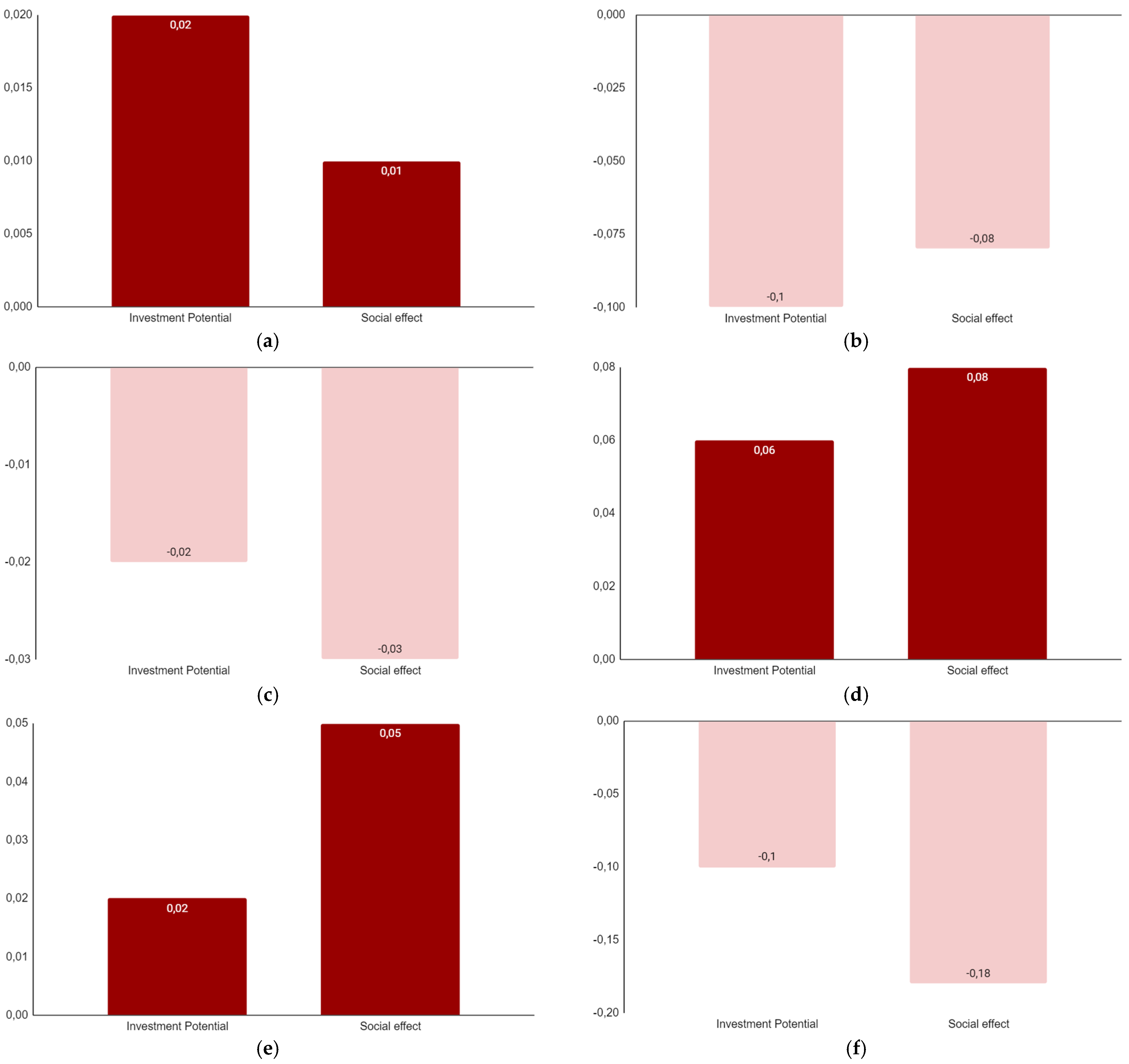
3.1. Scenario 1: Change of Land Use

The purpose of land use of an object plays a key role in determining the number of funds that go to the federal, regional, and local budgets. Financial resources will be formed from the land tax, rent, and the cost of the land.
Expansion of the land use types of the object within the category under consideration will increase the profitability of the object. This will lead to an increase in the cadastral value of the property and its value to the surrounding development (Figure 7a).
Figure 7b shows a scenario that is associated with inefficient land use or long-term non-use of the object. Target factors acquire negative values in the implementation of this scenario. This confirms the hypothesis about the formation of lost profits due to inefficient use of the territory.

3.2. Scenario 2: Change in the Size of a Vacant Land Plot, Change in the Devaluation of Building Objects

The following scenario includes a combination of factors of changing the size of the vacant land plot and the devaluation of building objects. The land plot and the buildings located on it represent a single balanced real estate object. The values of the target indicators become negative when predicting the development of the situation (Figure 7c).
The result of this scenario is due to the gradual accumulation of cumulative depreciation (physical, functional, and external) for buildings. The presence of physical deterioration is not typical for the land. However, the size of a vacant land plot, taking into account changing external conditions, also loses its advantages, since the efficiency of its use is steadily declining.
The values of the target criteria become positive during actions related to the reconstruction, modernization of existing objects, and the reduction of vacant land plots (Figure 7d).
In this case, the system of land and buildings (building objects) acquires new properties. The balance of interaction within the created system makes it more resistant to the influence of the external environment. This also gives it certain competitive advantages for further development.

3.3. Scenario 3: Change of Owner’s Authority

The legal boundaries for the use/disposal of an object are determined by the range of rights that are established by law for a real estate object. Figure 7e reflects the situation regarding the expansion of property rights.
The range of possibilities for using the object expands in this situation. This increases the economic and social potential and increases the territory use efficiency.
The ability to manage changes is significantly reduced when rights to an object are restricted. This leads to a decrease in social effects and economic benefits (Figure 7f).
The narrowing of the boundaries of legal possibilities creates a threat of economic damage in the process of using the object and leads to a decrease in the value of the object for a potential investor.

3.4. Solution of a Multicriteria Problem

The construction of a cognitive model allows us to assess the need to transform the existing territory based on the current situation in the city as a whole. Projects that do not allow for the best scenarios implementation can be excluded from consideration based on the analysis. The fuzzy optimization method was used to rank three projects that were selected at the preliminary stage. The criteria for comparison have been described above. The initial data for project analysis are determined on the basis of previously implemented projects for the construction of sports facilities and medical centers in Russian cities. These data give an idea of the final technical indicators of projects during their implementation (Table 5).
Pairwise comparisons over the entire set of alternatives must be carried out to solve the problem. Pairwise comparisons were made over the entire Cartesian set, i.e., according to the rule “each with each”. The first alternative is compared with the second and third, the second is also compared with the third for each criterion separately.
Pairwise comparison matrices for each of the six criteria were generated and the values of the priority vectors were calculated to find a solution (Table 6).
Table 7 shows the solution of the considered multi-criteria problem.
The project for the construction of a swimming pool is the most attractive based on the results of the analysis. This project outperforms other projects in four out of six criteria.

4. Discussion

The developed model was used to analyze the possibilities of transforming a local area in the city of Pallasovka (Volgograd region, Russia). A detailed analysis of the socio-economic state of the study area makes it possible to construct scenarios for its development. These scenarios are a way to explore strategies for improving the efficiency of land use and justify the selection of projects at a preliminary stage.
Scenarios of influence of the criteria “Land Use”, “Size of Vacant Land Plots”, “Devaluation of Existing Objects” and “Owner Powers” on the target criteria were implemented. Scenario analysis showed that actions to increase the size of a vacant land plot and devaluate building objects have the greatest impact on investment potential and social effects. The influence of these factors reflects the following statement: the consumer’s perception of the territory under consideration occurs primarily through the compositional picture created by the land and property complex of the territory under study. The social aspect is manifested in the reluctance of city residents to visit morally and physically obsolete buildings. This does not allow for generating high yields on objects and attracting additional investors to vacant land plots. As a result, the investment potential has rather low values.
The actions of related criteria (expansion of the rights of the owner and change in the land use of the existing development) can be considered as an additional tool for the development of the territory. However, the modeling of the considered scenarios does not give a clear idea of the options for the most effective change in their land use. In addition, it is difficult for the developer to determine which of the presented scenarios will provide him with the maximum profitability and normal payback period of the project based on the presented models. Therefore, three possible alternative projects for the transformation of the territory were considered on the basis of the identified most significant ways of influencing social and economic factors.
Land use for the project was established based on the study of the opinion of the local population. Specific needs and resources were analyzed to determine the combined properties of the project that would provide the resident with the greatest satisfaction of their need. Additionally, modern requirements for the transformation of existing territories were taken into account.
The proposed solution makes it possible to carry out a risk analysis based on an assessment of the influence of various factors, to agree on development goals, and to increase the validity of the choice of alternative projects. This distinguishes it from existing approaches to solving the problem of choosing options for territory development. The proposed method contributes to the implementation of the principle of the most effective use in terms of managing the development of the city territory: the method provides legal permission, physical feasibility, financial validity, and maximum profitability.
Thus, the integration of fuzzy cognitive modeling and fuzzy multicriteria optimization makes it possible to increase the objectivity of the analysis of strategies for the development of urban areas. Fuzzy multi-criteria optimization allows for taking into account many criteria that are important for the development of the territory, including economic, social, environmental, and others. Fuzzy cognitive modeling allows taking into account uncertainty and fuzziness in the formation of sustainable development goals and identifying contradictions between them. This allows for the uncertainty of conditions that change over time and fuzziness in the data to make more flexible decisions when prioritizing goals. In general, the integration of the methods makes it possible to take into account various factors that affect the development of cities and increases the objectivity of the analysis of urban development strategies [49,50,51,52,53].

5. Conclusions

The substantiation of the strategy for the development of an urban area is a multi-stage organizational process that has complex (direct and feedback) links. This process combines the intellectual activity of specialists from various fields using various models and methods, as well as modern technology for collecting, transmitting, processing, and coordinating information. At the same time, the decision-making strategy for the development of urban areas is associated with a certain risk. The risk arises due to the incomplete amount of initial information, the lack of a hierarchy in the criteria for importance and insignificance, a superficial study of the original problem, and a conservative approach of the project manager based on personal experience.
Cognitive modeling allows a deeper study of the existing problems of the development of a particular territory, predicting possible errors and analyzing the consequences of decisions made. The inclusion of scenario modeling using fuzzy cognitive maps in the decision-making process improves the most responsible and time-consuming stage, which is associated with the analysis of information and the formulation of the choice problem. This preliminary analysis provides the basis for selecting the most suitable development projects for the area.
The necessary indicators characterizing the territory were determined as a result of the research. Technologies for collecting information for their evaluation have been developed. The ability to analyze the impact of various factors on economic and social indicators, taking into account uncertainties and risks, is a feature of the proposed approach. At the same time, the opportunity to take into account the characteristics of the analyzed territory becomes possible due to the involvement of not only experts but also ordinary residents in the assessment and construction of models.
The results of the study can be used to identify the best urban development projects and to analyze the improvement impacts in urban development management. The developed models can be applied to other objects if it is possible to collect enough information. Methods of spatial analysis based on GIS technologies are supposed to be included to obtain detailed information about natural, environmental, and other factors that must be taken into account when analyzing options for the development of the territory. Another direction of development of the proposed approach is to improve the criteria selection process and reduce the complexity of the evaluation procedure through the use of methods based on data analysis.

Author Contributions

Conceptualization, N.S. and D.P.; methodology, N.S. and O.S.; software, A.S.; validation, O.S., A.C. and D.P.; formal analysis, O.S. and A.S.; investigation, O.S. and A.S.; resources, A.C.; data curation, O.S., A.S. and A.C.; writing—original draft preparation, N.S. and O.S.; writing—review and editing, N.S. and D.P.; visualization, O.S., A.S. and D.P.; supervision, N.S.; project administration, D.P.; funding acquisition, D.P. All authors have read and agreed to the published version of the manuscript.

Funding

The study has been supported by the grant from the Russian Science Foundation (RSF) and the Administration of the Volgograd Oblast (Russia) No. 22-11-20024, https://rscf.ru/en/project/22-11-20024/ (accessed on 15 February 2022).

Data Availability Statement

Not applicable.

Acknowledgments

The authors express gratitude to colleagues of the Department of Digital Technologies for Urban Studies, Architecture and Civil Engineering, VSTU and the Urban Computing Laboratory (UCLab) involved in the development of the UrbanBasis.com scientific projects, and especially to Dmitry Boyko for the inspiration and non-trivial ideas for this study.

Conflicts of Interest

The authors declare no conflict of interest.

References

  1. Zelenskiy, I.; Parygin, D.; Savina, O.; Finogeev, A.; Gurtyakov, A. Effective Implementation of Integrated Area Development Based on Consumer Attractiveness Assessment. Sustainability 2022, 14, 16239. [Google Scholar] [CrossRef]
  2. Mason, R. Economics and Historic Preservation: A Guide and Review of the Literature; The Brookings Institution: Washington, DC, USA, 2005; p. 75. [Google Scholar]
  3. Rypkema, D.R.; Cheong, C. Measuring Economic Impacts of Historic Preservation; Advisory Council on Historic Preservation: Washington, DC, USA, 2011; p. 83. [Google Scholar]
  4. Polidi, T.D. Economics of Urban Redevelopment: Foreign Experience; Foundation “Institute of Urban Economics”: Moscow, Russia, 2017; p. 32. (In Russian) [Google Scholar]
  5. Del Giudice, V.; De Paola, P.; Bevilacqua, P.; Pino, A.; Del Giudice, F.P. Abandoned Industrial Areas with Critical Environmental Pollution: Evaluation Model and Stigma Effect. Sustainability 2020, 12, 5267. [Google Scholar] [CrossRef]
  6. Della Spina, L. Cultural Heritage: A Hybrid Framework for Ranking Adaptive Reuse Strategies. Buildings 2021, 11, 132. [Google Scholar] [CrossRef]
  7. How to Value Real Estate Investment Property. Available online: https://www.investopedia.com/articles/mortgages-real-estate/11/valuing-real-estate.asp (accessed on 27 December 2022).
  8. Stas, N. The Economics of Adaptive Reuse of Old Buildings: A Financial Feasibility Study & Analysis; UWSpace: Waterloo, ON, Canada, 2007. [Google Scholar]
  9. D’Adamo, I.; Gastaldi, M.; Ioppolo, G.; Morone, P. An analysis of Sustainable Development Goals in Italian cities: Performance measurements and policy implications. Land Use Policy 2022, 120, 106278. [Google Scholar] [CrossRef]
  10. González-Méndez, M.; Olaya, C.; Fasolino, I.; Grimaldi, M.; Obregón, N. Agent-Based Modeling for Urban Development Planning based on Human Needs. Conceptual Basis and Model Formulation. Land Use Policy 2021, 101, 105110. [Google Scholar] [CrossRef]
  11. Giles-Corti, B.; Lowe, M.; Arundel, J. Achieving the SDGs: Evaluating indicators to be used to benchmark and monitor progress towards creating healthy and sustainable cities. Health Policy 2020, 124, 581–590. [Google Scholar] [CrossRef] [PubMed]
  12. Giannetti, B.F.; Agostinho, F.; Almeida, C.M.V.B.; Liu, G.; Contreras, L.E.V.; Vandecasteele, C.; Coscieme, L.; Sutton, P.; Poveda, C. Insights on the United Nations Sustainable Development Goals scope: Are they aligned with a ‘strong’ sustainable development? J. Clean. Prod. 2020, 252, 119574. [Google Scholar] [CrossRef]
  13. Deal, B.; Pan, H.; Zhuang, Y. 2.19—Modeling Land-Use Change in Complex Urban Environments. In Comprehensive Geographic Information Systems; Huang, B., Ed.; Elsevier: Amsterdam, The Netherlands, 2018; pp. 401–423. [Google Scholar]
  14. Samson, C.; Freudendal-Pedersen, M. Restructuring urban planning to facilitate sustainable consumption. Front. Sustain. 2022, 3, 918546. [Google Scholar] [CrossRef]
  15. Pérez, M.G.R.; Laprise, M.; Rey, E. Fostering sustainable urban renewal at the neighborhood scale with a spatial decision support system. Sustain. Cities Soc. 2018, 38, 440–451. [Google Scholar] [CrossRef]
  16. Morano, P.; Tajani, F.; Di Liddo, F.; La Spina, I. The Evaluation in the Urban Projects Planning: A Logical-Deductive Model for the Definition of “Warning Areas” in the Esquilino District in the City of Rome (Italy). Smart Cities 2023, 6, 469–490. [Google Scholar] [CrossRef]
  17. Xu, K.; Shen, G.Q.; Liu, G.; Martek, I. Demolition of Existing Buildings in Urban Renewal Projects: A Decision Support System in the China Context. Sustainability 2019, 11, 491. [Google Scholar] [CrossRef] [Green Version]
  18. Kara, C.; Iranmanesh, A. Modelling and Assessing Sustainable Urban Regeneration for Historic Urban Quarters via Analytical Hierarchy Process. Land 2023, 12, 72. [Google Scholar] [CrossRef]
  19. Lin, S.-H.; Huang, X.; Fu, G.; Chen, J.-T.; Zhao, X.; Li, J.-H.; Tzeng, G.-H. Evaluating the sustainability of urban renewal projects based on a model of hybrid multiple-attribute decision-making. Land Use Policy 2021, 108, 105570. [Google Scholar] [CrossRef]
  20. Wang, Z.; Chen, X.; Huang, N.; Yang, Y.; Wang, L.; Wang, Y. Spatial Identification and Redevelopment Evaluation of Brownfields in the Perspective of Urban Complex Ecosystems: A Case of Wuhu City, China. Int. J. Environ. Res. Public Health 2022, 19, 478. [Google Scholar] [CrossRef]
  21. Pazzini, M.; Corticelli, R.; Lantieri, C.; Mazzoli, C. Multi-Criteria Analysis and Decision-Making Approach for the Urban Regeneration: The Application to the Rimini Canal Port (Italy). Sustainability 2023, 15, 772. [Google Scholar] [CrossRef]
  22. Cinelli, M.; Coles, S.R.; Kirwan, K. Analysis of the Potentials of Multi Criteria Decision Analysis Methods to Conduct Sustainability Assessment. Ecol. Indic. 2014, 46, 138–148. [Google Scholar] [CrossRef] [Green Version]
  23. Parygin, D.; Sadovnikova, N.; Gamidullaeva, L.; Finogeev, A.; Rashevskiy, N. Tools and Technologies for Sustainable Territorial Development in the Context of a Quadruple Innovation Helix. Sustainability 2022, 14, 9086. [Google Scholar] [CrossRef]
  24. Wang, H.; Zhao, Y.; Gao, X.; Gao, B. Collaborative decision-making for urban regeneration: A literature review and bibliometric analysis. Land Use Policy 2021, 107, 105479. [Google Scholar] [CrossRef]
  25. Bottero, M.; Assumma, V.; Caprioli, C.; Dell’Ovo, M. Decision making in urban development: The application of a hybrid evaluation method for a critical area in the city of Turin (Italy). Sustain. Cities Soc. 2021, 72, 103028. [Google Scholar] [CrossRef]
  26. Szulkin, M.; Garroway, C.J.; Corsini, M.; Kotarba, A.Z.; Dominoni, D. How to Quantify Urbanization When Testing for Urban Evolution. In Urban Evolutionary Biology; Szulkin, M., Munshi-South, J., Charmantier, A., Eds.; Oxford University Press: Oxford, UK, 2020; pp. 13–35. [Google Scholar]
  27. Vukomanovic, J.; Smart, L.S. GIS Participatory Modeling. In The Geographic Information Science & Technology Body of Knowledge, 1st ed.; Wilson, J.P., Ed.; UCGIS: Ithaca, NY, USA, 2021. [Google Scholar]
  28. Gao, J.; O’Neill, B.C. Mapping global urban land for the 21st century with data-driven simulations and Shared Socioeconomic Pathways. Nat. Commun. 2020, 11, 2302. [Google Scholar] [CrossRef]
  29. Nuissl, H.; Siedentop, S. Urbanisation and Land Use Change. In Sustainable Land Management in a European Context; Weith, T., Barkmann, T., Gaasch, N., Rogga, S., Strauß, C., Zscheischler, J., Eds.; Springer: Cham, Switzerland, 2021; pp. 75–99. [Google Scholar]
  30. Hester, P. Analyzing Stakeholders Using Fuzzy Cognitive Mapping. Procedia Comput. Sci. 2015, 61, 92–97. [Google Scholar] [CrossRef] [Green Version]
  31. Avdeeva, Z.K.; Kovriga, S.V. On Situation Control Problem Settings with Multiple Stakeholders Using Cognitive Maps. Autom. Remote Control 2020, 81, 139–152. [Google Scholar] [CrossRef]
  32. Barbrook-Johnson, P.; Penn, A.S. Fuzzy Cognitive Mapping. In Systems Mapping; Palgrave Macmillan: Cham, Switzerland, 2022; pp. 79–95. [Google Scholar]
  33. Sadovnikova, N.; Parygin, D.; Gnedkova, E.; Kravets, A.; Kizim, A.; Ukustov, S. Scenario forecasting of sustainable urban development based on cognitive model. In Proceedings of the IADIS International Conference, Section I, Prague, Czech Republic, 24–26 July 2013; pp. 115–119. [Google Scholar]
  34. Sadovnikova, N.; Parygin, D.; Gnedkova, E.; Sanzhapov, B.; Gidkova, N. Evaluating the sustainability of Volgograd. In The Sustainable City VIII, Proceedings of the Eight International Conference on Urban Regeneration and Sustainability, Section 3, Putrajaya, Malaysia, 3–5 December 2013; WIT Press: Hampshire, UK, 2013; pp. 279–290. [Google Scholar]
  35. Gray, S.A.; Gray, S.; Cox, L.J.; Henly-Shepard, S. Mental Modeler: A Fuzzy-Logic Cognitive Mapping Modeling Tool for Adaptive Environmental Management. In Proceedings of the 2013 46th Hawaii International Conference on System Sciences, Wailea, HI, USA, 7–10 January 2013; pp. 965–973. [Google Scholar]
  36. Gray, S.A.; Zanre, E.; Gray, S.R.J. Fuzzy Cognitive Maps as Representations of Mental Models and Group Beliefs. In Fuzzy Cognitive Maps for Applied Sciences and Engineering; Papageorgiou, E., Ed.; Springer: Berlin/Heidelberg, Germany, 2014; pp. 29–48. [Google Scholar]
  37. Jones, N.A.; Ross, H.; Lynam, T.; Perez, P.; Leitch, A. Mental Models: An Interdisciplinary Synthesis of Theory and Methods. Ecol. Soc. 2011, 16, 46. [Google Scholar] [CrossRef]
  38. Papageorgiou, E.I.; Papageorgiou, K.; Dikopoulou, Z.; Mouhrir, A. A web-based tool for Fuzzy Cognitive Map Modeling. In Proceedings of the 9th International Congress on Environmental Modelling and Software, Fort Collins, CO, USA, 24–28 June 2018. [Google Scholar]
  39. Firmansyah, H.S.; Supangkat, S.H.; Arman, A.A.; Giabbanelli, P.J. Identifying the Components and Interrelationships of Smart Cities in Indonesia: Supporting Policymaking via Fuzzy Cognitive Systems. IEEE Access 2019, 7, 46136–46151. [Google Scholar] [CrossRef]
  40. Henly-Shepard, S.; Gray, S.A.; Cox, L.J. The use of participatory modeling to promote social learning and facilitate community disaster planning. Environ. Sci. Policy 2015, 45, 109–122. [Google Scholar] [CrossRef]
  41. Bellman, R.E.; Zadeh, L.A. Decision making in a fuzzy environment. Manag. Sci. 1970, 17, 141–164. [Google Scholar] [CrossRef]
  42. Traneva, V.; Tranev, S. Intuitionistic Fuzzy Model for Franchisee Selection. In Intelligent and Fuzzy Systems; Kahraman, C., Tolga, A.C., Cevik Onar, S., Cebi, S., Oztaysi, B., Sari, I.U., Eds.; Springer: Cham, Switzerland, 2022; pp. 632–640. [Google Scholar]
  43. Traneva, V.; Tranev, S. Intuitionistic Fuzzy Approach for Outsourcing Provider Selection in a Refinery. In Large-Scale Scientific Computing; Lirkov, I., Margenov, S., Eds.; Springer: Cham, Switzerland, 2022; pp. 266–274. [Google Scholar]
  44. Kulba, V.V.; Kononov, D.A.; Kosyachenko, S.A.; Shubin, A.N. Methods for the Formation of Scenarios for the Development of Socio-Economic Systems; SINTEG: Moscow, Russia, 2004; p. 296. (In Russian) [Google Scholar]
  45. Zadeh, L.A. Fuzzy sets. Inf. Control 1965, 8, 338–353. [Google Scholar] [CrossRef] [Green Version]
  46. Rotshtein, A.P.; Shtovba, S.D. Fuzzy Multicriteria Analysis of Variants with the Use of Paired Comparisons. J. Comput. Syst. Sci. Int. 2001, 40, 499–503. [Google Scholar]
  47. Rashevskiy, N.; Sadovnikova, N.; Ereshchenko, T.; Parygin, D.; Ignatyev, A. Atmospheric Ecology Modeling for the Sustainable Development of the Urban Environment. Energies 2023, 16, 1766. [Google Scholar] [CrossRef]
  48. Mental Modeler. Available online: https://www.mentalmodeler.com/ (accessed on 15 January 2023).
  49. Poczeta, K.; Papageorgiou, E.I.; Gerogiannis, V.C. Fuzzy Cognitive Maps Optimization for Decision Making and Prediction. Mathematics 2020, 8, 2059. [Google Scholar] [CrossRef]
  50. Zhang, J.; Hou, Y.; Dong, Y.; Wang, C.; Chen, W. Land Use Change Simulation in Rapid Urbanizing Regions: A Case Study of Wuhan Urban Areas. Int. J. Environ. Res. Public Health 2022, 19, 8785. [Google Scholar] [CrossRef] [PubMed]
  51. Wang, W.-M.; Peng, H.-H. A Fuzzy Multi-Criteria Evaluation Framework for Urban Sustainable Development. Mathematics 2020, 8, 330. [Google Scholar] [CrossRef] [Green Version]
  52. Ketipi, M.K.; Karakasis, E.G.; Koulouriotis, D.E.; Emiris, D.M. Multi-Criteria Decision Making using Fuzzy Cognitive Maps—Preliminary Results. Procedia Manuf. 2020, 51, 1305–1310. [Google Scholar] [CrossRef]
  53. Petukhova, A.V.; Kovalenko, A.V.; Ovsyannikova, A.V. Algorithm for Optimization of Inverse Problem Modeling in Fuzzy Cognitive Maps. Mathematics 2022, 10, 3452. [Google Scholar] [CrossRef]
Figure 1. Decision support method in substantiating urban areas development strategies.
Information 14 00241 g001
Figure 2. Cognitive map for the analysis of area development options.
Information 14 00241 g002
Figure 3. The study area (highlighted in yellow) is on a fragment of the public cadastral map of the city of Pallasovka, Volgograd Region, Russia.
Information 14 00241 g003
Figure 4. Urban environment quality index in Pallasovka, Volgograd Oblast, Russia.
Information 14 00241 g004
Figure 5. Indicators of the quality of the urban environment in the city of Pallasovka, Volgograd Oblast, Russia.
Information 14 00241 g005
Figure 6. Adjacency matrix of study area factors.
Information 14 00241 g006
Figure 7. Simulation results for the following scenarios: (a) increasing the influence of the criterion “Land Use” on the target criteria; (b) reducing the influence of the criterion “Land Use” on the target criteria; (c) increasing the influence of the criteria “Size of Vacant Land Plots” and “Devaluation of Building Objects” on the target criteria; (d) reducing the influence of the criteria “Size of Vacant Land Plots” and “Devaluation of Building Objects” on the target criteria; (e) increasing the influence of the “Owner’s Authority” criterion on the target criteria; (f) reducing the influence of the “Owner’s Authority” criterion on the target criteria.
Information 14 00241 g007
Table 1. Types and sources of information.
Types
of Information
DescriptionSources
StatisticalDemographic, production, financial, environmental indicators, etc.Statistical and financial database, state real estate cadaster, state cadaster of natural resources, censuses, surveys, monitoring information systems
SpatialAreas of functional zones, parameters of objects, length and density of the transport network, parameters of engineering infrastructure, parameters of landscaping, relief features, types of vegetation, and other semantic informationGIS, cartographic fund
Regulatory-ReferenceLaws, regulations, sanitary norms and rules, standards, etc.Legislative information bases, industry information funds
AnalyticalResults of forecasts, expert analysis, data miningDatabases of monitoring systems, expert sourcing systems
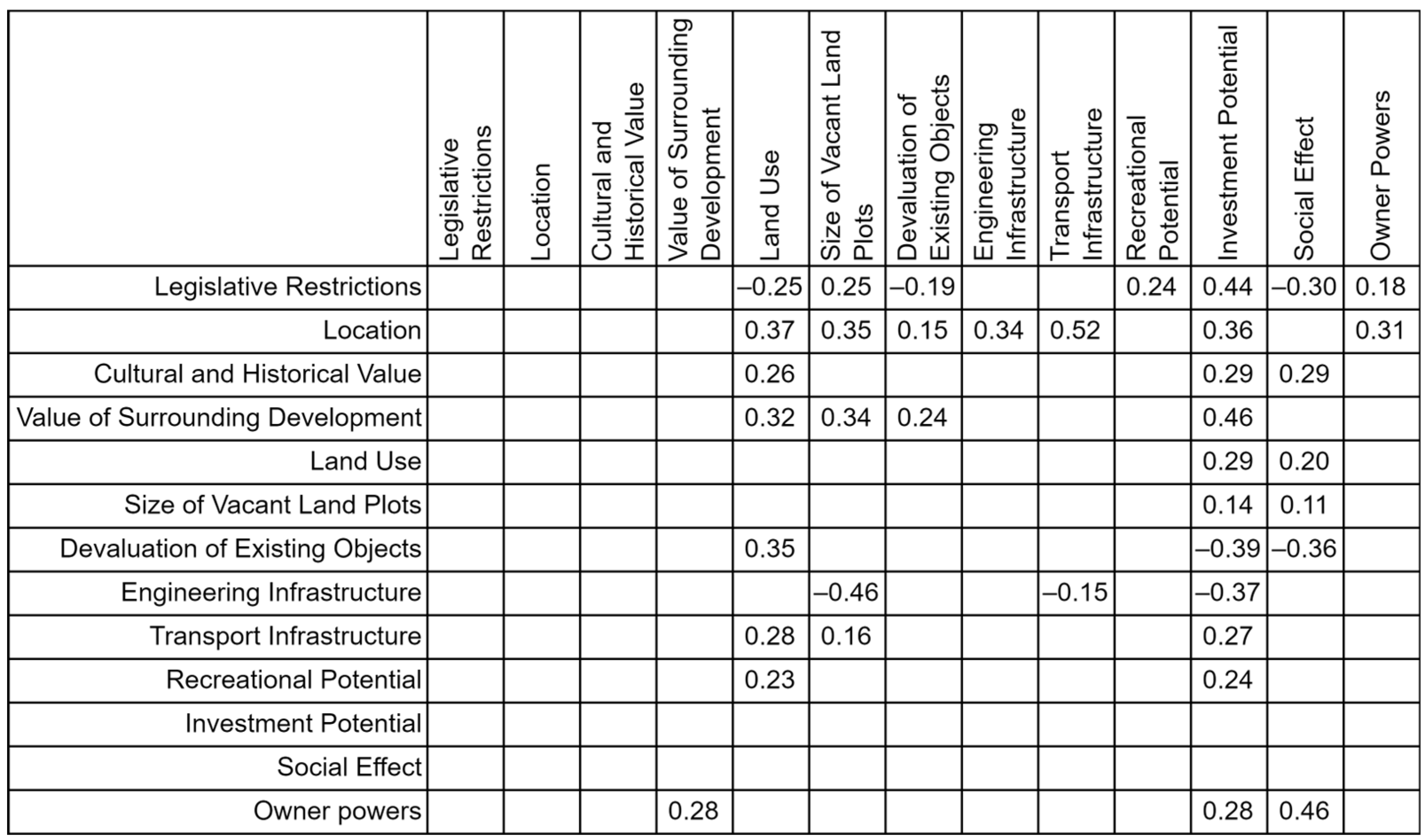
Table 2. Factors that determine the urban areas' development strategies.
NFactorDescription
1External factors
1.1Legislative RestrictionsRegulatory framework for construction
1.2Value of Surrounding DevelopmentObjects of historical and cultural heritage, building after 2000
1.3LocationNatural and climatic conditions, area relief, position relative to the central part of the city
1.4Cultural and Historical ValueNational mentality, cultural and historical features of the territory
2Adjustable factors
2.1Land UseChanging the functional use by changing the permitted use of the object, taking into account the most rational use, revaluation of the cadastral value of the object (changes in objects profitability)
2.2Size of Vacant Land PlotsVariation in the parameters of the land plot, based on the availability of free space, the proposed boundaries for the implementation of the integrated area development
2.3Devaluation of Existing ObjectsChange in the technical condition (wear and tear) of the existing building, energy efficiency class of objects, aesthetic appearance of objects, compliance with the requirements for the number of stores (height) of buildings
2.4Engineering InfrastructureAvailability of engineering communications, their technical condition
2.5Transport InfrastructureTransport links with local centers of city districts
2.6Recreational PotentialAvailability of recreation facilities (park, square, boulevard, alley, water body)
2.7Owner PowersChange in scope of rights of the real estate owner
3Target factors
3.1Investment PotentialChanges in the economic attractiveness of the city, sources of economic development, changes in the income level of the population
3.2Social EffectSocio-ecological characteristics of the territory (change in population, ecological state of the urban environment, comfort of living)
Table 3. Description of the object of study.
IndexDescription
Region, districtRussia, Volgograd Oblast, city of Pallasovka
Geospatial location characteristicPallasovka is a city (since 1967) in Russia, the administrative center of the Pallasovsky district of the Volgograd Oblast. It belongs to the small towns of Russia in terms of population. The city is located in the steppe in the northeast of the Volgograd region. Distance by road to the regional center, the city of Volgograd—280 km, to the nearest large city (Saratov)—230 km
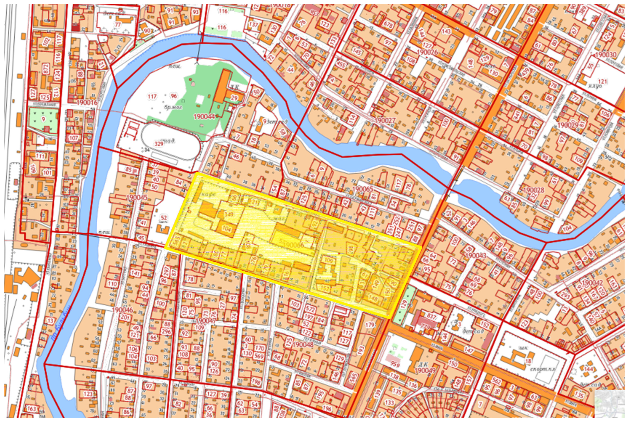
Intracity locationThe city of Pallasovka is conditionally divided into the following parts: “Center”, “Daws”, “3rd Youth Brigade”, “6th Quarter”, “Zalineiny District”, “Zarechny District” and “Dachi”.
The object of study is located in the Zarechny area. Cadastral quarter 34:23:190,066
Microdistrict predominant developmentResidential low-rise buildings and individual residential buildings (construction period 1960–1980), administrative buildings, retail and sports facilities
Prestige of the microdistrictMedium: located in close proximity to the central part of the city.
Availability of public transport/transport accessibility
(subjective assessment)
Medium: a public transport stop is located on one of the streets limiting the microdistrict
Area ecological situationGood: located at a slight distance from the central park of the city, the Bulbin River; the communal warehouse complex located on the territory is not subject to negative environmental impact
Availability of social infrastructure facilities (subjective assessment)An area with a moderately developed infrastructure: in the immediate vicinity of the quarter there is a secondary school No. 12, the Kolos sports stadium, the Romashka kindergarten, a sports school, and a regional house of culture; on the territory of the quarter there is a sports and recreation complex Sokol; at a slight distance from the quarter there is a youth center Spektr; Central district hospital and children’s polyclinic are located at a considerable distance
Objects of the industrial infrastructure of the microdistrictEnterprises of public utility and warehouse purposes (middle class of sanitary hazard) are located on the territory of the quarter
Distance from the main streets (highways) of the cityThe quarter is located in close proximity to the main streets of the city (Ostravskaya St., Budenny St., Krasnoarmeyskaya St.)
Condition of the territory (subjective assessment)Poor improvement of the quarter territory: no pedestrian paths, no landscaping, the roadway is worn out
Functional zones within the boundaries of the cadastral quarterThere are two zones: (i) the zone for the formation of residential areas with the placement of apartment buildings 4–5 floors (a wide range of local services is allowed, utilities without exceeding the permissible levels of environmental impact); (ii) the zone to ensure the legal conditions for the formation of public utility enterprises of the middle class of sanitary hazard, requiring the organization of sanitary protection zones with a radius of 300 m (some commercial services are allowed that contribute to the development of production activities; a combination of various types of permitted use of real estate in a single zone is possible only subject to regulatory sanitary requirements)
Table 4. Advantages and disadvantages of the study area.
AdvantagesDisadvantages
Proximity to the central part of the city (the center of business and cultural activity of the population)Inconsistency in the legal statuses of land plots located on the quarter territory
Variability of permitted use of the territoryRestriction on the number of stories (height) of the buildings
Proximity to the developed infrastructure of the cityLow efficiency of the use of existing buildings, the presence of vacant land plots
Close proximity to consumers (population)Insignificant socio-economic effects of exploitation
Table 5. Technical parameters of projects.
Name of IndicatorDimensionNumerical Values for the Project
Construction
of a Sports Center with a Swimming Pool
Construction of an Ice
Arena
Construction
of a Building
of the Medical and Diagnostic Center
Total building aream243782022.592629.73
Structural volume of the buildingm320,37714,641.2935,769.80
Total land aream242284432.954197
Built-up aream221142211.981865
Capacitypeopleup to 100
(grandstand)
up to 5001000
Table 6. Priority vector values.
Priority Vector NameProject
Swimming PoolIce ArenaMedical and
Diagnostic Center
Priority vectors for object uniqueness0.677420.225810.09678
Priority vectors for social significance0.666670.166670.16667
Priority vectors for operational complexity0.744690.148940.16667
Priority vectors for environmental impact0.157890.526320.3158
Priority vectors for the project payback period0.677420.225810.09677
Priority vectors for project budget efficiency0.652170.217390.13043
Table 7. Solution evaluation results.
Fuzzy SolutionProject
Swimming PoolIce ArenaMedical and
Diagnostic Center
Intersection of Particular Criteria0.157890.148940.09678
Disclaimer/Publisher’s Note: The statements, opinions and data contained in all publications are solely those of the individual author(s) and contributor(s) and not of MDPI and/or the editor(s). MDPI and/or the editor(s) disclaim responsibility for any injury to people or property resulting from any ideas, methods, instructions or products referred to in the content.

