Article

Impact of Rice Expansion on Traditional Wetland Management in the Tropical Highlands of Ethiopia

1
Ethiopian Institute of Architecture, Building Construction, and City Development, Addis Ababa University, Addis Ababa P.O. Box 518, Ethiopia
2
Water and Land Resource Center (WLRC), Addis Ababa University, Addis Ababa P.O. Box 3880, Ethiopia
3
College of Agriculture, Biotechnology and Natural Resources, University of Nevada, Reno, NV 89557-0222, USA
4
Amhara Design and Supervision Works Enterprise, Bahir Dar P.O. Box 1921, Ethiopia
*
Author to whom correspondence should be addressed.
Agriculture 2022, 12(7), 1055; https://doi.org/10.3390/agriculture12071055
Submission received: 6 June 2022 / Revised: 4 July 2022 / Accepted: 6 July 2022 / Published: 19 July 2022
(This article belongs to the Section Agricultural Technology)

Abstract

:
Despite the fact that rice was only recently brought to Ethiopia, the Ethiopian government has dubbed it the “millennium crop” because of its importance as a food security crop, as well as a source of revenue and job possibilities. Rice production is being practiced on wetland areas and floodplains; however, no attention has been given to the sustainability of these wetlands, or to the integration of different previous indigenous activities, such as livestock rearing and farming of different crops in the area. This study aims to investigate the impact of rice expansion on traditional wetland management in the Fogera floodplain wetlands of the Lake Tana basin. Data were generated via interviews and the application of GIS and remote sensing. The survey questionnaire was administered to 385 rice-producing farmers. The respondents (87%) confirmed that increases in the price of rice encouraged them to shift from the cultivation of conventional crops to rice farming. Subsequently, between the years 1973 and 2014, wetland areas have been reduced from 3114 ha to 1060 ha, accompanied by a high rate of expansion in rice production in the area. Major activities being pursued in the wetlands of the study area do not consider environmental impacts. As a result, the diverse ecosystem services available in the past have been compromised through time. Sense of ownership of wetland resources and their benefit shall be communicated to reduce abusive utilization. Therefore, the policies, strategies, and development activities implementation need to consider environmental issues in rice production enhancement endeavors.

1. Introduction

The interest in rice (Oryza sativa L.) has increased by up to 70% over the course of the last thirty years, as most nonindustrial nations depend on rice as a staple food; for example, Africa’s rice consumption is about 21 million metric tons per year [1,2]. Rice farming in Ethiopia began in the early 1970s on the plains of Fogera and Gambella (districts, or “woredas”, in Ethiopia) [3]. Rice production has caused changes in production and livelihoods, which has an impact on human–environment interactions. Despite the fact that rice was brought to Ethiopia from abroad, the Ethiopian government has dubbed it the “millennium crop” because of its importance as a food security crop, as well as a source of revenue and job possibilities [4].
Fogera “Woreda” (District) is a major rice growing area in Ethiopia, accounting for 58% of rice output in the Amhara region and 28% of Ethiopian rice production [5]. Currently, rice is one of the principal food and income-generating crops grown by the majority of farmers in the woreda [6]. However, no attention has been given to the sustainability of wetlands or the integration of different previous indigenous activities, such as livestock rearing and farming of different crops in the area [7].
Due to the importance of wetland ecosystems to rural livelihoods, resource sustainability needs to be ensured through understanding current utilization patterns and the indigenous knowledge of local people [8]. Traditional ecological knowledge (TEK) is the knowledge held by local cultures about their immediate environment, and the cultural management practices that build on that knowledge [9]. Furthermore, traditional resource management (TRM) refers to managing environmental uncertainty to optimize sustainable resource extraction [10]. The TEK and TRM practices help better manage ecosystem services and understand socio ecological and adaptive management systems [11]. Nonetheless, studies conducted recently mainly focus on rice productivity and surrounding watershed issues rather than sustainability issues. They emphasize ways to increase rice yield and market profitability. For example, the costs and returns of rice production in Fogera [12], the commercialization of rice, profitability, and marketing issues [7], and the yield response of rice to different input regimes to establish the optimum nitrogen and phosphorus fertilizer levels [13].
Therefore, this study aimed to: (1) identify trends in rice expansion in the Fogera wetlands and evaluate the effects of market prices and other issues on rice expansion, (2) determine how rice expansion has impacted TRM in the Fogera wetlands, and (3) identify the current situation in terms of ecosystem functions and services in the study area.

2. Materials and Methods

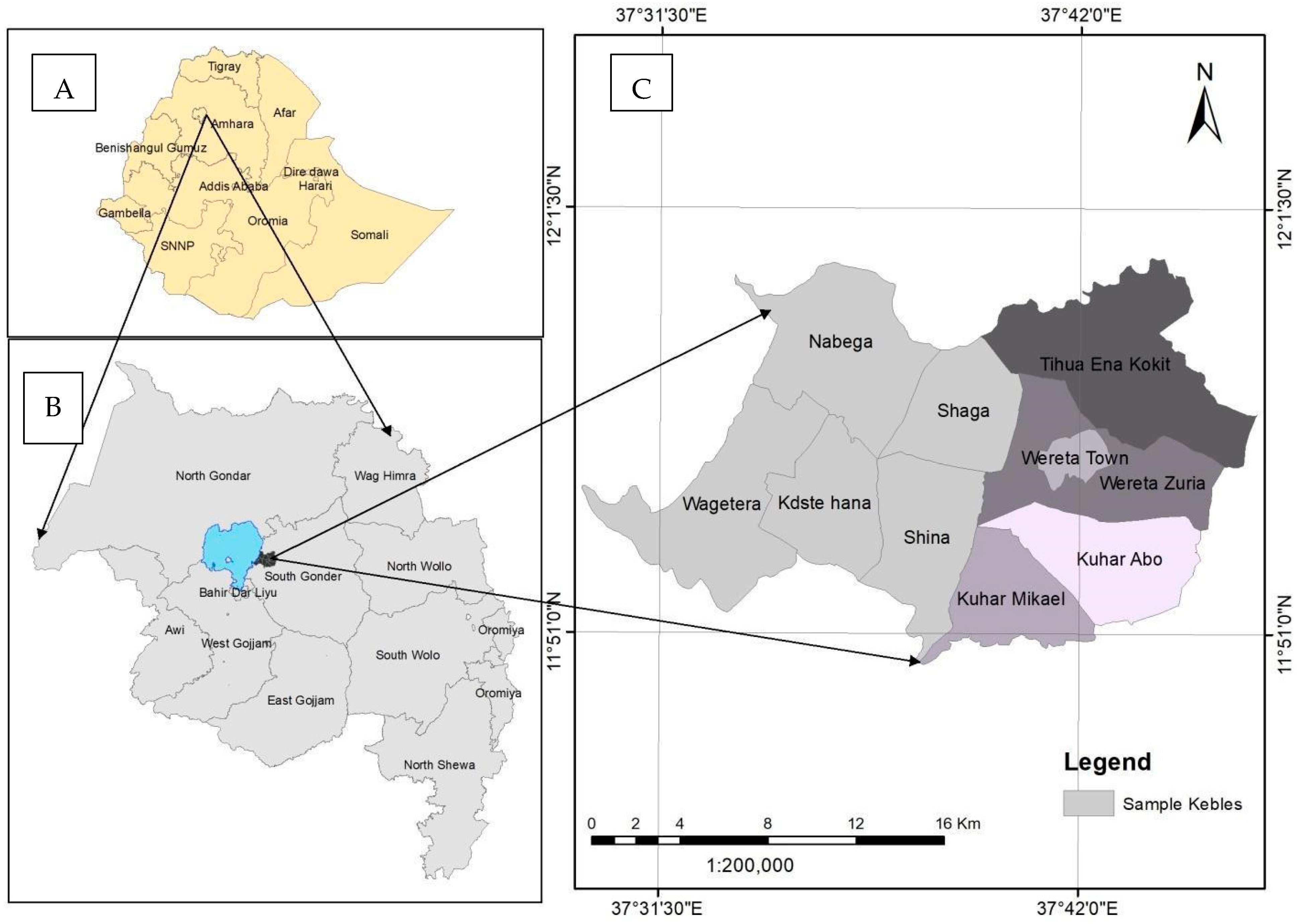
Study Area Description

Fogera Woreda is situated between 11°46′ and 11°59′ N and 37°33′ and 37°52′ E (Figure 1), and the altitude of the woreda ranges from 1774 to 2410 masl. Mean annual rainfall is approximately 1216 mm, and the season from June to September contributes 60% to 80% of the annual rainfall. The Fogera floodplain is located within the eastern shores of the biosphere reserves (BRs) of Lake Tana—a UNESCO world heritage site [14]. Fogera Woreda is a major rice-producing area, and has strong potential for rice production. The area receives much of the floodwater that accumulates around Lake Tana and the two large rivers (Ribb and Gumara). The eroded soils from the rivers upstream are deposited in the lowland plain; the soil is/seems relatively deep and fertile. In the study area, rice is planted at lower slopes where the water table moves to the surface for a substantial period during the rainy season. Rice is irrigated with water, which is diverted from the streams in the upper part of a drainage system. However, in Fogera and the nearby woredas, the water supply to the rice crop is principally provided by rainfall, runoff, and groundwater. Bunds (constructed from local soil as a barrier) are usually used for rain-fed rice production. The bunds serve to retain floodwater and rainwater, which falls during the growing season.

Sampling Procedure and Data Collection

The Lake Tana region consists of 10 woredas and 137 kebeles (the smallest administrative unit). Based on a preliminary assessment during a field visit, and subject matter expert interviews (Agricultural and Environment Protection) of the BR sites, it was found that the wetlands are highly vulnerable to the environmental tradeoff (encroachment of wetland resources). Due to the different development activities, such as rice intensification, irresponsible fishing, sand extraction, and illegal recession farming. For this study, five kebeles were selected (Table 1). Initially, the kebeles that are included in the BR were identified as rice-producing wetland. The sample sizes were determined using Yamane’s [15] approach:
n = N 1 + N ( e ) 2
Thus, we obtained a total sample size of:
n = 10122 1 + 10122 ( 0.05 ) 2 = 385
where n = sample; N = population (10,122); e = error term (5%); sourced from [15].
The formula for the determination of the required number of households in an individual kebele was:
S = T N H × T S H T H S
where S is the number of required household samples for each kebele; TNH is the total number of households in a kebele; TSH is the total number of sample households; and THS is the total households of all sampled kebeles. Thus, for the Nabega kebele:
2283 × 385 10122 = 87
Interview data: The data were collected from farming households using a structured questionnaire and focus group discussions (FGD) based on initiative points. Households were selected for interview proportionally from each kebele using a systematic random sampling approach. One FGD was undertaken for each sampled kebele with seven participants; 35 in total from five kebeles. Participants for the discussion were selected purposefully from different parts of the community; youths, women, and elders. The number of respondent households in each kebele was proportional to the total population size; 385 in total (Table 1). The list of farming households was obtained from the kebele governmental offices.
The hydrological data: Daily precipitation data of the Amed Ber, Woreta, Addis Zemen, and Yifag stations were collected from the Ethiopian Meteorological Agency (EMA), situated in the northwest sub-city of Bahir Dar. The dataset was not up to date or complete for all stations. Therefore, remote sensing precipitation data from the Climate Hazards Group InfraRed Precipitation with Station Data (CHIRPS) with 0.05 arc degree resolution were downloaded for the period 1 January 1981 to 30 September 2019 using the Google Earth Engine cloud computing platform [16]. CHIRPS was chosen because it holds long-term daily data with the best resolution and performance for this location [16]. The hydrology was characterized for the entire floodplain using Ribb River data at the lowest gaging station located at 12.00 N and 37.716 E. The flow data of the floodplain were generated using the SWAT 2012 model. The Ribb River observational flow data for the calibration were obtained from the Ministry of Water, Irrigation, and Electricity (MoWIE), spanning from 1985 to 2014.
Data analysis: Data collected using questionnaires were summarized in percentages using SPSS version 21, and the qualitative data through narrative analysis. The hydrology of the wetland was analyzed. River flow regime changes and indices were analyzed using Indicators of Hydrological Alteration (IHA) software version 7.1 [17]. Setting up and completing analysis in IHA involved the use of hydrologic data as the input, deciding analysis years, and water year starting Julian date [17]. Hydrological data for the Ribb River collected from 1981 to 2018 were imported in CSV file format and saved as an internal hydrologic file. A project was then created, linked to a single hydrologic data file, and used to create and run multiple analyses. The water year was set to start on 1 January and to end on 31 December, which is suitable for floodplain flow conditions. In addition, image processing for land use analysis was performed using ArcGIS10.3. Change matrices were developed to interpret the change in the wetland for the years 1973 and 2014. The area covered by each land use land cover (LULC) class was calculated and, subsequently, the changes were compared for the years 1973 and 2014. The LULC classification scheme used in this study was adapted from Namugize et al. [18].

3. Results

3.1. Market Information and Participation in Rice Production

The farming production system was changing because of the better market price of rice, second to teff (Eragrostis tef), according to all of the respondents. Rice became a dominant crop in the study area, while crops such as green pepper (Capsicum spp.), maize (Zea mays L.), noug (Guizotia abyssinica), and finger millet (Eleusine coracana) were almost out of production, except in small pocket localities of the study area.
A total of 87% of the farmers participated in the rice markets, where they sold portions of their rice produce, whereas 13% of the respondents used the rice for household consumption (Table 2).
Farmers were motivated to produce more rice than other crops because of high price and demand; market price 63%, consumer demand 20.5%, and demand for rice seed 15.9% (Table 3). Therefore, market forces were driving factors for the farmers to produce more rice than other crops.
Regarding the supply of rice grain, 94.5% of the sampled households responded that there was not enough rice in the market; thus, conversely, 5.5% said there was enough rice in the market (Table 4). This situation encouraged farmers towards the expansion of rice farming.
Becoming informed on the market demand for their crop was necessary for farmers to produce more rice. Farmers are aware of the market demand for rice crops. Respondents (96.4%) agreed that there was a high demand for rice in the market center of the woreda; whereas 3.6% said there was no demand for rice in the market center of the woreda (Table 5). This motivated farmers to expand and intensify rice farming practices rather than using previous practices.
The general consensus of the farmers was the need for an improved rice marketing system. The system should encourage farmers throughout wetland kebeles to participate in rice production, provide access to rice threshing machines for all farmers (villages), enhance infrastructure (roads), improve the variety of rice, and ensure good market linkage in the input–output systems.

3.2. The Impacts of Rice Price on Traditional Wetland Management Practices

The traditional practices referred to in this study are those that the farmers were previously practicing in the wetland areas. These activities are agricultural activities, such as maize (Zea mays L.) and green pepper (Capsicum spp.) production using livestock manure, the production of noug (Guizotia abyssinica) in the floodplains, and fish harvesting in the wetlands (floodplain). Wetland communities used pastures in recently flooded areas for cattle grazing, and forest and bushland were common in floodplains, which were being used as a source of fuel wood. According to the Nature and Biodiversity Conservation Union (NABU) experts and FGD participants, the elderly people had indigenous knowledge of using wetland resources, such as papyrus, reeds, brooms, and Butia capitata, for different purposes (Figure 2). Presented in Figure 2 are the indigenous knowledge-based activities once practiced by local people.
According to respondents (61.6%), traditional wetland management practices were influenced by the rice market, as the increase in the prices of rice grain led to departures from traditional agricultural practices; additionally, 25.7% of the respondents said the prices of rice almost eliminated the traditional practices in the study area. In contrast, 4.2% of the respondents said that trends in the price of rice encouraged farmers to preserve their traditional practices, and about 12.7% of the respondents were not sure of what counts as traditional knowledge/practice in the study areas (Table 6, Figure 2).

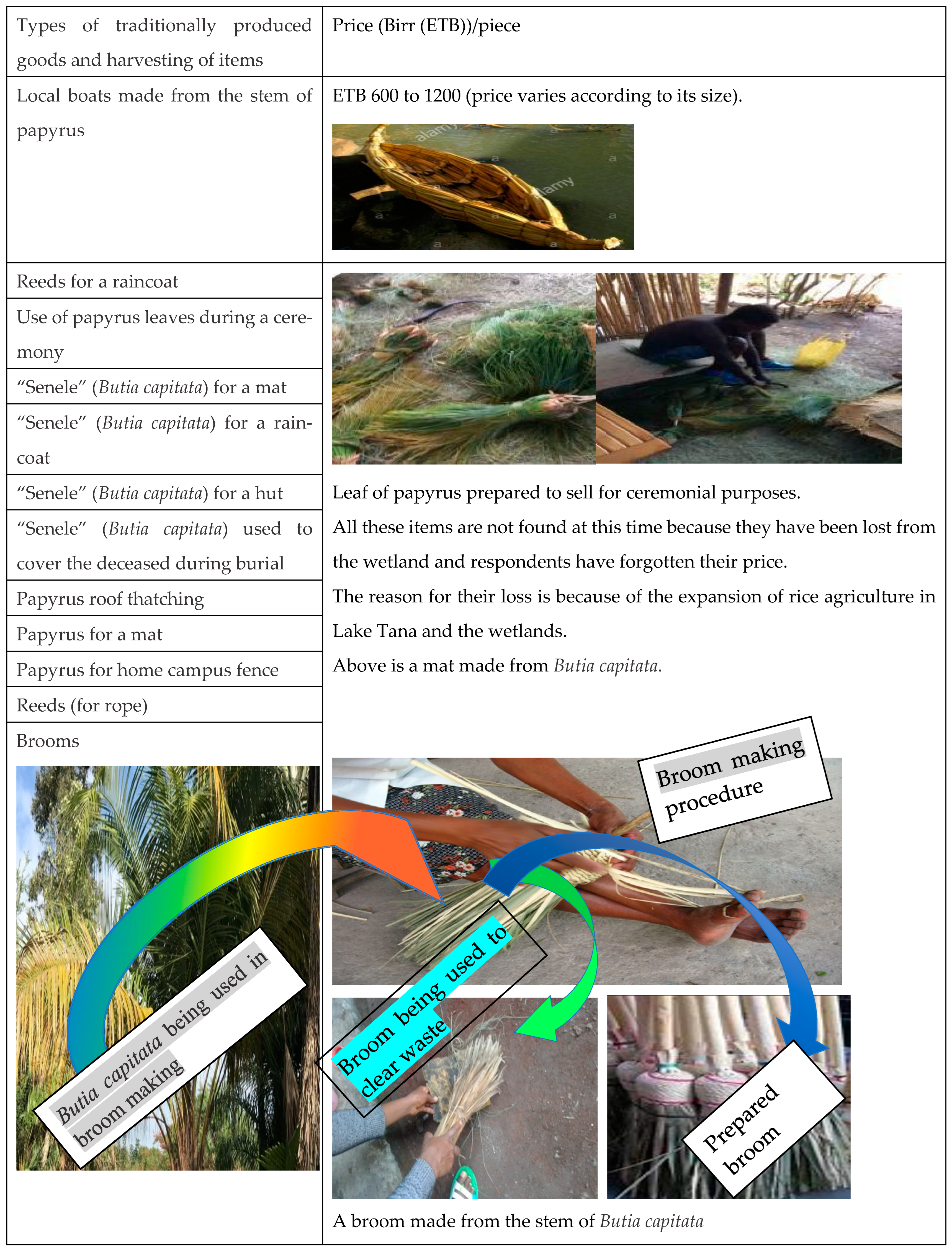
3.2.1. Farmers’ Understanding of Traditionally Produced Goods from Wetland Resources

Before the introduction of rice, 26% of the respondents claimed that there were traditionally produced goods from wetland resources and the surrounding Lake Tana areas, whereas 74% of the respondents stated that there were no goods produced traditionally from wetland resources during this study (Table 7).

3.2.2. Local Peoples’ Perception on Wetland Functions and Services

According to the farmers’ explanations, the functions and services of wetland resources were available in the past, but they have been reduced over time (Table 8). Respondents also mentioned that the reduction in and loss of these wetland resources are not only depriving the community, but also contributing to the loss of their traditional practices. Loss of traditional practices is attributed to rice expansion occurring at the expense of wetland resources.
Regarding hydrologic function, respondents explained that the whole study area is inundated during the summer season with floodwater from the uplands. Therefore, the floodplains are very important for the farmers to produce more rice. However, they also mentioned that the level of water in the floodplain (wetlands) has dropped compared to past levels. Thus, the hydrologic functions of the wetlands varied seasonally (Figure 3). The frequency of extremely low flow, small floods, and the large floods have all shown a decreasing trend (Figure 4). Trends were tested with a Mann–Kendall trend test, and were found to be significant at p = 0.02 for extreme low flow, and p = 0.5 for small and large floods (Figure 4). Therefore, there has been a hydrological alteration of the wetland/floodplain areas, especially regarding the low flows, which has led to the disruption of normal hydrologic functions and services.

3.2.3. Farmers’ Perception of the Effects of Rice Market on Wetland Resources

A total of 57.9% of the respondents’ strongly agreed that the increase in the market price of rice has had negative effects on traditional wetland resources management; 34.6% of the respondents agreed, and 7.5% were undecided (Table 9), and a further 7.5% abstained. Overall, 92.5% of the respondents said that rice price affects wetland resources in the study area.

3.3. Farmers’ Participation in Biodiversity Conservation

Farmers’ Willingness to Support the Efforts of the Nature and Biodiversity Conservation Union

It was found that 57.1% of the respondents demonstrated a willingness to support the efforts of the NABU to implement the biosphere reserve principles in their kebeles (Table 10). Another 13% of the respondents indicated that they were not willing to support the efforts of the NABU, whereas 29.4% of the respondents did not know anything about the program. About 70.1% of the respondents receive information about the efforts of NABU. The unwillingness of some of the respondents may be due to fear of a legal framework that would not allow them to illegally encroach the wetlands or communal grazing lands to expand rice farming. During the promotion of any development activities, the participation of local farmers and stakeholders is essential; this is because awareness creates a sense of responsibility among the local community, and thereby helps to sustain the development project in their local environment.

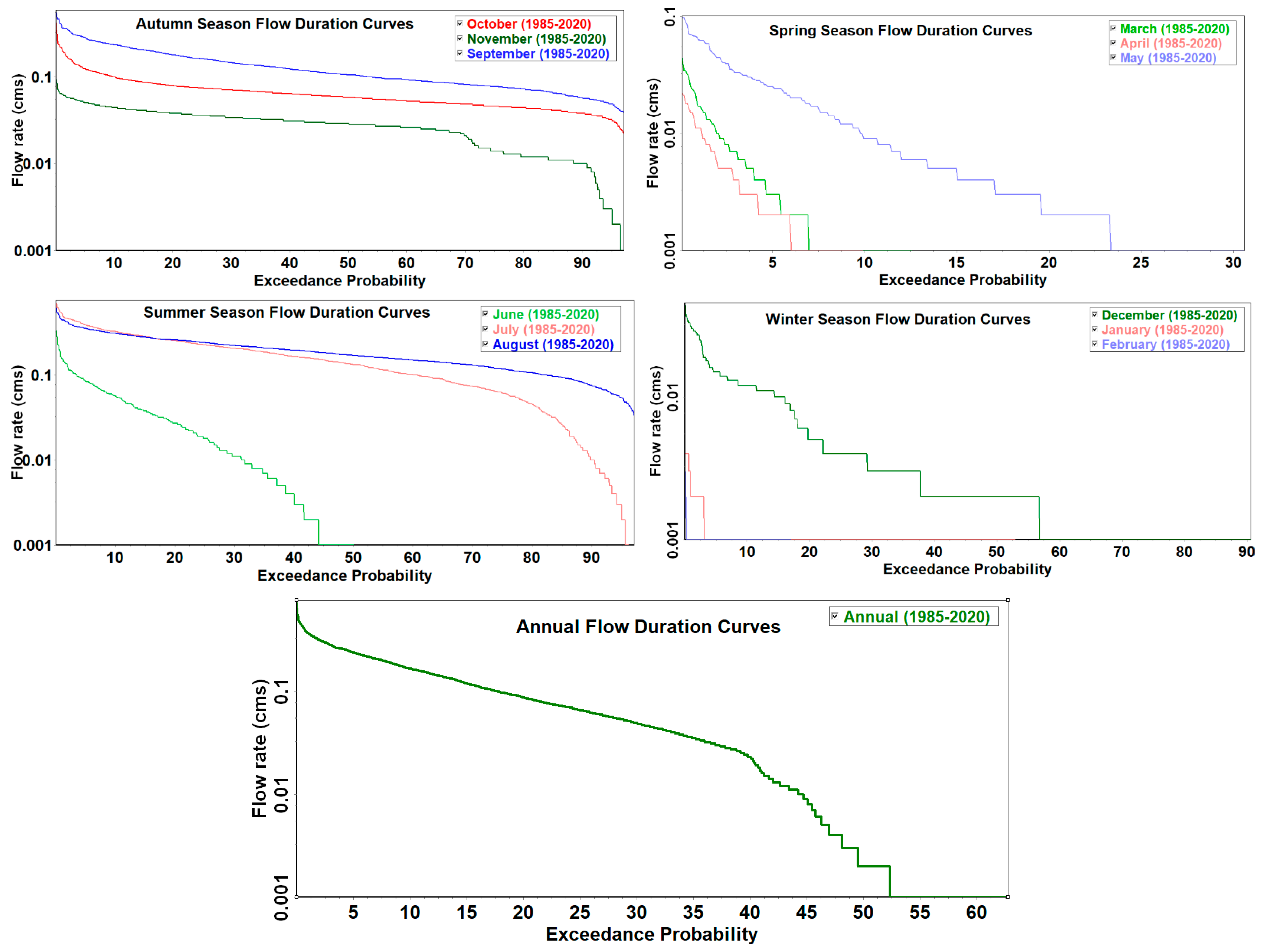
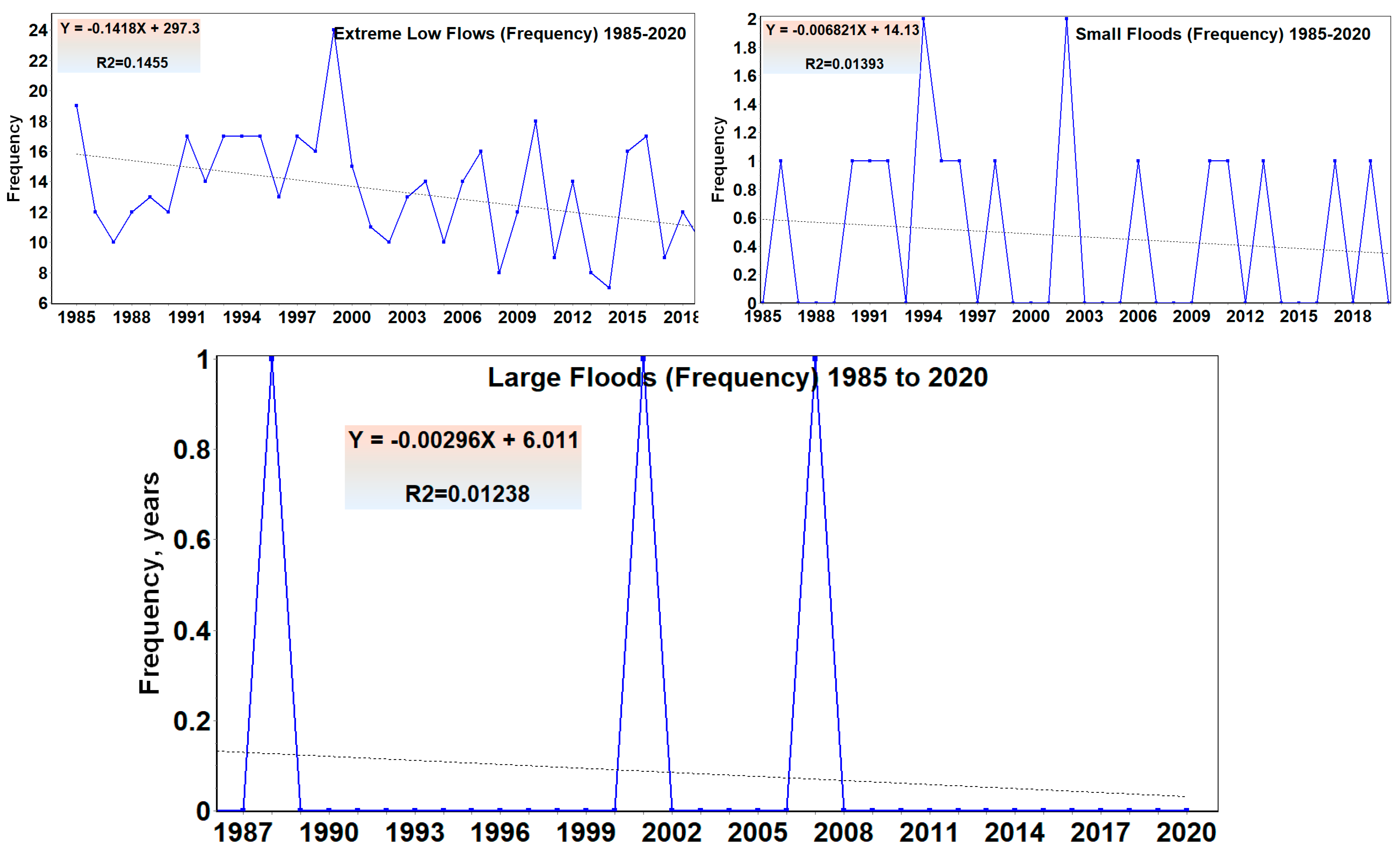
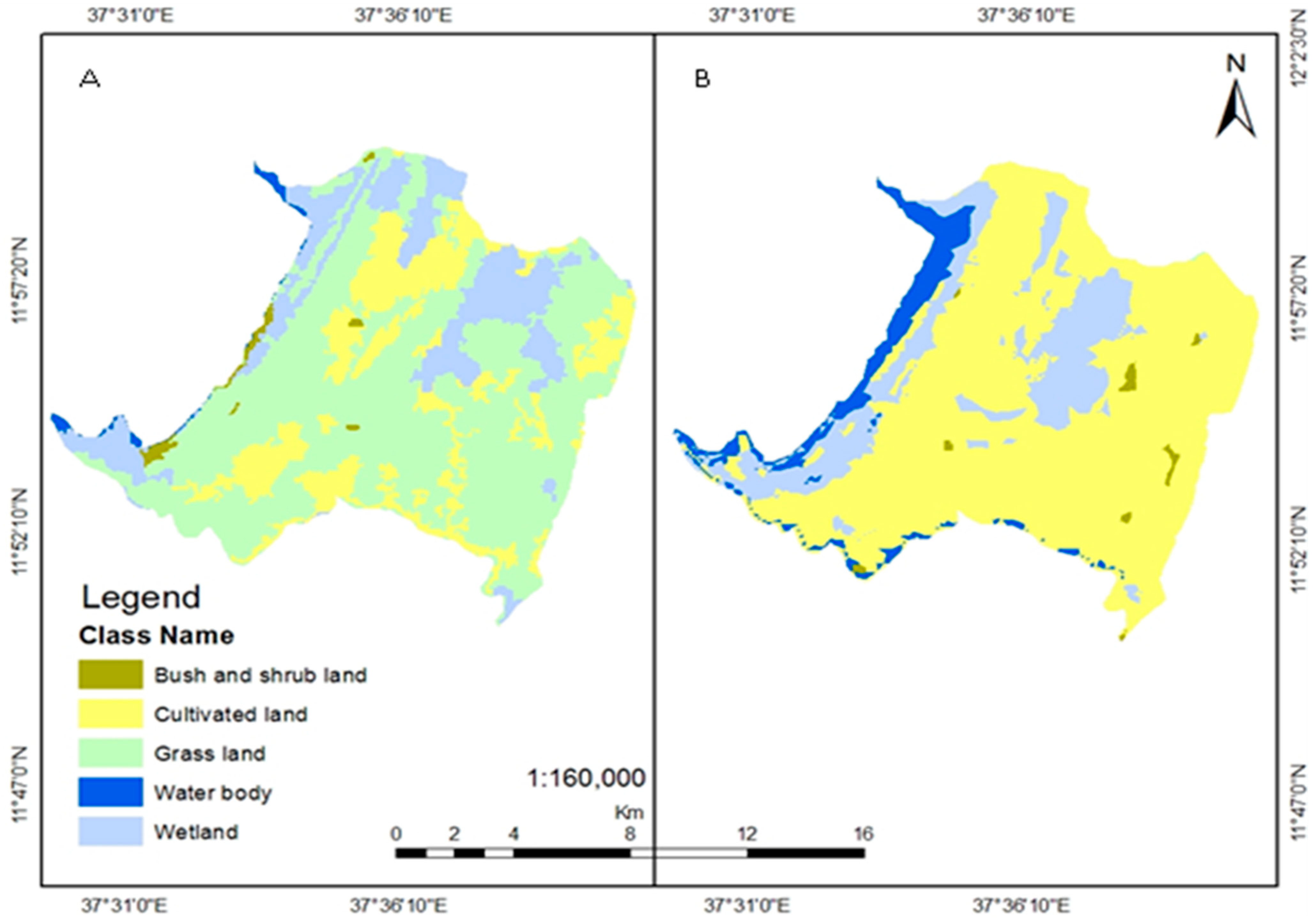
3.4. Wetland Reduction Detection

Wetland areas were greatly reduced in favor of rice farms between 1973 (Figure 5A) and 2014 (Figure 5B). The area of wetlands has declined in most land categories except for agricultural land. Quantitative comparisons for changes in land use are shown in (Figure 5); wetlands from 3114 ha (or 18% of land area) to 1060 ha (or 6% of land area). Based on the map, cultivated land area increased from 3441 ha (or 20% of land area) to 11,550 ha (or 67% of land area), and water surface area from 502 ha (or 3% of the study area) to 907 ha (or 5% of the study area). This is because the price of rice encouraged the farmers to incorporate wetlands into their farmland to produce more rice. Therefore, rice production has not only intensified, there has also been an extensification of rice crop area in the studied wetlands.
In the past, the border of Lake Tana and wetlands were covered by vegetation, such as reeds, Butia capitata (palm tree) long grasses, and papyrus. Currently, the vegetation has been removed around the shoreline of the Lake and the wetlands because of flood recession farming and for dry season small-scale irrigation (Figure 6).

4. Discussion

It is crucial to understand how wetland habitats are used for rice production in order to preserve their long-term viability. We investigated the impact of rice price on the expansion of rice production and traditional wetland management in the Fogera wetlands, on the eastern shore of Lake Tana, northern Ethiopia, using a combination of approaches, including key informant interviews, Focus Group Discussions (FGD) of sampled farmers, records of hydrological alterations in the floodplain wetlands, and spatial analysis of land use changes. The areas of both permanent and seasonal wetlands have declined, while agricultural land has expanded, according to these findings. Because rice has a higher price than other crops, it is encouraged to expand agricultural land at the expense of wetlands and grazing grounds. This issue is consistent with the findings of Gebremedhin et al. [19], who found that rising rice prices increased the extension of rice production, encouraging farmers to expand rice farming into wetlands. Rice has also become a significant component of the farming systems in the Fogera area according to Chanie et al. [20], and the Fogera floodplain produces 32% of rice production in the country. Furthermore, the expansion of rice output was mostly found to be beneficial in terms of household income, although livestock numbers, production, and transportation were reduced according to Amsalu, T. and Addisu, S. [21]. Because of their capacity for high biomass production, seasonal wetlands, such as the Fogera floodplain, can supply excellent feedstock for livestock [10]. The Fogera marshes in Ethiopia have been frequently used for livestock grazing for millennia [22]. Farmers, on the other hand, are increasingly choosing rice over other crops due to its high yield and market price compared to other crops [23]. It has also altered the source and distribution of income [22].
Rice production and profitability in the Fogera wetlands has been the subject of a lot of research. Other studies of the Lake Tana basin, where the Fogera floodplain wetlands drain, focus on integrated fertilizer management [24], value chains [25], weed management [6], water availability and management as a result of livestock [26], climate change [27], land use patterns [28], and nonpoint source pollution [29]. Crop cultivation is estimated to be the primary source of revenue for rice farmers, followed by animal keeping. Approximately 90% of rice farmers said that crops were their main source of income, whereas only about 6% said livestock was their main source of revenue [7]. Rice producers earn an average of ETB 14,908 (USD 847) per hectare, with the lowest revenue income of zero and the greatest revenue income of ETB 103,000 (USD 5852) per hectare [30].
Wetlands are the world’s most productive ecosystems, far surpassing some of the other uses to which they are put. Herbaceous marshes, for example, produce high primary output every year. Papyrus may yield up to 143 tons per hectare in tropical Africa, whereas Typha yields between 30 and 70 tons per hectare. Wetlands and their importance are still poorly recognized, and their extinction is fast becoming an environmental catastrophe. While wetland loss rates in wealthy countries have been reported, less is known about similar ecosystems in developing countries such as Ethiopia [31].
Wetlands help to maintain ecological balance in the ecosystem by ensuring the integrity of life support systems, which is essential for long-term socioeconomic growth. However, many wetland ecosystems, particularly floodplains and swamps, are considered to be wastelands, and are rapidly depleting across Ethiopia. The hydrological analysis in the Fogera floodplain wetlands depicted that both low and high flows are decreasing, which has resulted in the loss of ecologically important papyrus and reeds. This may be the cause of the loss of migratory birds that use the Fogera floodplain wetlands as their roosting site [14]. Furthermore, national economic policies that promote agricultural production have a negative impact on sensitive habitats, such as wetlands, through vast land expansion schemes that disregard environmental consequences. The monetary values of lost or gained uses in relation to the value of agricultural rice production are unknown. Other substantial benefits lost that cannot be quantified, such as the cost of supplying alternative sources of income, water, food, flood protection, biodiversity, and amenity values, may also need to be considered.
During environmental impact assessments, balancing the costs of preserving wetland functions and values against alternative rice production and questions of sustainability are essential considerations [31]. According to various researchers’ points of view, the majority of the studies explain that the expansion and productivity of agriculture in wetlands or floodplains are resulting in a loss of biodiversity due to ecosystem degradation. The increase in rice farming is linked to the expansion of farmland on wetlands, which is seen as a greater source of income for present use. It is difficult to discover research findings that indicate a comparison of the worth of lost wetland area with an increase in overall farm income. Is the value of the economic gains from rice cultivation outweighed by the economic losses from the loss of natural wetlands in terms of quantity and quality? Based on this premise, no researchers have been able to demonstrate that rice cultivation can compensate for the economic losses caused by the quality and quantity of natural wetlands.
Many studies focus on agricultural development and productivity, as opposed to the few studies that focus on wetland losses as a result of agricultural expansion. Alemu et al. [7] indicated that the Fogera district is one of Ethiopia’s prospective rice production locations, contributing 32% of the country’s rice production; in 2008 and 2010, this proportion reached 40%. For example, intensive rice production and free grazing activities in Shesher and Welala wetlands resulted in a drastic shrinkage in their coverage [32]. In turn, agrochemical runoff could also affect biodiversity [14], for example, in reed plants of papyrus and Typha, animal fodder grasses, sand or peat soil. Reed plants were once collected to make reed boats, baskets, thatching, mattresses, and inflorescence was used for continuous and periodic festivals.
All of the foregoing difficulties corroborate the findings of this paper, showing that the natural resources of the wetlands of Fogera (Figure 2) were lost in recent years as a result of the increase in rice production in the Fogera wetlands. Hence, the functions and services of wetland resources (Table 8) have been diminished as rice expansion has taken place at the expense of wetlands. Concomitantly, there was also hydrological changes in the wetland floodplain areas, which caused normal hydrologic functions and services to be disrupted. For example, a study of the connected Gumara river indicated that the migratory Labeobarbus fishes, which inhabit the Fogera floodplain, are declining as a result of the hydrological alteration that has been ongoing for the last 20 years [33]. Many rivers have been drained to raise crops; additional effects include water diversion via irrigation canals, and excessive water extraction for intensive agriculture. Wetland water can be contaminated by fertilizers, pesticides, and other agrochemicals. As a result of humans attempting to boost agricultural output, many wetlands have been significantly and irreversibly altered [34].
The conclusions of this study agree with those of prior studies on two major points. The first is agricultural development with the intensification of rice production in wetlands, and the second is the threat that wetlands face when their resources are depleted. Further research is needed to determine the value of lost wetland area versus increased overall revenue for farmers, as well as the win–win scenario for future development, while considering the area’s wetland resource sustainability.

5. Conclusions

The wetlands in the Fogera floodplain are the hub for aquatic biodiversity that contribute significantly to the local community’s income, food, and jobs. Nowadays, the majority of the community relies on arable land for agriculture, particularly rice production, and relatively small-scale fisheries in the wetlands provide food security and jobs for the area’s rural inhabitants. Because of the strong demand for, and limited quantity of, rice on the market, thus making rice more profitable, farmers are attempting to expand rice production in wetlands, having switched from their previous conventional agricultural practices to rice production systems. This current rice agricultural production system is incompatible with wetland resources or wetland TEK preservation. As a result, wetland resources are being degraded from the pressure. Environmentally friendly, non-intensive production processes, and the marketing of regional products, should be encouraged even more in order to sustain wetlands. The Lake Tana Biosphere Reserve administration should be better integrated and used to promote the local tourism in order to preserve traditional knowledge and practices involving wetland resources. To establish a stronger TEK framework and policy, the research community should conduct more studies at the national and regional level. As a result, policymakers and stakeholders must collaborate on wetlands management, vis-à-vis, rice production intensification.

Author Contributions

Conceptualization, M.A.D., G.Z. and W.A.P.; methodology, M.A.D., W.A.P., G.Z. and W.B.A.; software, M.A.D. and W.B.A.; validation, G.Z. and W.A.P.; formal analysis, M.A.D. and W.B.A.; investigation, M.A.D.; resources, M.A.D., W.A.P.; data curation, M.A.D.; writing—original draft preparation, M.A.D.; writing—review and editing, M.A.D., G.Z., W.A.P. and W.B.A.; visualization, M.A.D., G.Z., W.A.P. and W.B.A.; supervision, G.Z. and W.A.P.; project administration, G.Z. and W.A.P.; funding acquisition, M.A.D. and W.A.P. All authors have read and agreed to the published version of the manuscript.

Funding

The publication fee is covered by University of Nevada, Reno (UNR).

Data Availability Statement

All data produced from this study are provided in this manuscript.

Acknowledgments

The authors acknowledge Addis Ababa and Wollo University for providing us with the opportunity to conduct this study; I would like to thank the Fogera Woreda Agriculture office for providing me with information and secondary data, and the development agents for assisting me in collecting data.

Conflicts of Interest

The authors declare that there is no financial or non-financial competing interest. The authors declare that they have no competing interests.

References

  1. Miruts, F. On-Farm Demonstration of Improved Rice (Oryza sativa L.) Varieties in Pawe Woreda of Benishangul Gumuz Regional State, Ethiopia. J. Biol. Agric. Healthc. 2020, 10, 57–61. [Google Scholar]
  2. Belayneh, T.; Tekle, J. Review on adoption, trend, potential, and constraints of rice production to livelihood in Ethiopia. Int. J. Res.-Granthaalayah 2017, 5, 644–658. [Google Scholar] [CrossRef]
  3. Fikeremariam, T.; Tamiru, D.; Brehanu, W.; Getnet, B.; Adem, K. Participatory upland rice (Oryza sativa L.) seed rate determination for row method of sowing under irrigated eco-system. Afr. J. Agric. Res. 2020, 16, 1093–1100. [Google Scholar] [CrossRef]
  4. Hagos, H.; Ndemo, E.; Yosuf, J. Factors affecting adoption of upland rice in Tselemti district, northern Ethiopia. Agric. Food Secur. 2018, 7, 59. [Google Scholar] [CrossRef]
  5. Lema, T.Z.; Tessema, S.A.; Abebe, F.A. Analysis of the technical efficiency of rice production in Fogera district of Ethiopia: A stochastic frontier approach. Ethiop. J. Econ. 2017, 26, 88–108. [Google Scholar]
  6. Desta, M.A.; Zeleke, G.; Payne, W.A.; Shenkoru, T.; Dile, Y. The impacts of rice cultivation on an indigenous Fogera cattle population at the eastern shore of Lake Tana, Ethiopia. Ecol. Process. 2019, 8, 19. [Google Scholar] [CrossRef]
  7. Alemu, D.; Tesfaye, A.; Assaye, A.; Addis, D.; Tadesse, T.; Thompson, J. A Historical Analysis of Rice Commercialization in Ethiopia: The Case of the Fogera Plain; 2018; APRA Working Paper 18; Future Agricultures Consortium; ISBN 978-1-78118-504-9. Available online: https://opendocs.ids.ac.uk/opendocs/handle/20.500.12413/14283 (accessed on 5 July 2020).
  8. Dixon, A.; Wood, A.; Hailu, A. Wetlands in Ethiopia: Lessons from 20 years of Research, Policy and Practice. Wetlands 2021, 41, 1–14. [Google Scholar] [CrossRef]
  9. Corbett, L. Avatimik Kamattiarniq: Arctic Ecology and Environmental Stewardship, by Jordan Hoffman with contributing authors Neil Christopher, Pascale Baillargeon, Christina Clow, Julia Landry, Sarah Young and Laura Edlund. Arctic 2019, 72, 321–322. [Google Scholar] [CrossRef]
  10. MEA. Ecosystems and Human Well-Being: Ecosystem Services Synthesis; World Resources Institute: Washington, DC, USA, 2005. [Google Scholar]
  11. Ibrahim, O. Ecological knowledge and sustainable planning in Nigeria: A reflection on the yorubas of south-western Nigeria. Часonuc Coціально-Економічної Географії 2017, 23, 45–48. [Google Scholar]
  12. Ayalew, B.; Aber, S.; Bekel, A.; Assaye, A.; Mela, A.; Adamu, F.; Mazengia, Y.; Teshale, D. Costs and Returns of Rice Production under Smallholder Farming in Fogera and Pawe. In Advances in Rice Research and Development in Addis Ababa, Ethiopia; 2019; ISBN 9789994466641245. Available online: http://www.eiar.gov.et (accessed on 5 July 2020).
  13. Abebe, T.; Alamerew, S.; Tulu, L. Traits association and path coefficient analysis of yield and related traits in rainfed lowland rice (Oryza sativa L.) genotypes in North Western Ethiopia. Afr. J. Plant Sci. 2019, 13, 1–8. [Google Scholar]
  14. Zur Heide, F. Feasibility Study for a Lake Tana Biosphere Reserve, Ethiopia; Bundesamt für Naturschutz, BfN: Bonn, Germany, 2012. [Google Scholar]
  15. Yamane, T. Statistics: An Introductory Analysis, 2nd ed.; Harper and Row: New York, NY, USA, 1967. [Google Scholar]
  16. Funk, C.; Peterson, P.; Landsfeld, M.; Pedreros, D.; Verdin, J.; Shukla, S.; Husak, G.; Rowland, J.; Harrison, L.; Hoell, A.; et al. The climate hazards infrared precipitation with stations—A new environmental record for monitoring extremes. Sci. Data 2015, 2, 150066. [Google Scholar] [CrossRef] [PubMed] [Green Version]
  17. TNC. Indicators of Hydrologic Alteration Version 7.1: User’s Manual; The Nature Conservancy: Arlington County, VA, USA, 2009. [Google Scholar]
  18. Namugize, J.N.; Jewitt, G.; Graham, M. Effects of land use and land cover changes on water quality in the uMngeni river catchment, South Africa. Phys. Chem. Earth Parts A/B/C 2018, 105, 247–264. [Google Scholar] [CrossRef]
  19. Gebremedhin, B.; Hoekstra, D.; Bogale, A.; Berhe, K.; Tegegne, A. Summary Report of Market-Oriented Developmental Changes in the IPMS Pilot Learning Woredas; IPMS (Improving Productivity and Market Success) of Ethiopian Farmers Project Working Paper 30; ILRI: Nairobi, Kenya, 2012. Available online: http://www.ipms-ethiopia.org/http://www.eap.gov.et/ (accessed on 5 July 2020).
  20. Chanie, Y.; Zemedu, L.; Teklewold, T. Farmers’ participation in farmers research groups and its contribution on their income on rice; empirical evidence from rice production systems of Fogera district, Ethiopia. J. Econ. Sustain. Dev. 2014, 5, 13. [Google Scholar]
  21. Amsalu, T.; Addisu, S. Assessment of Grazing Land and Livestock Feed Balance in Gummara-Rib Watershed; Bahir Dar University: Bahir Dar, Ethiopia, 2014. [Google Scholar]
  22. Anteneh, M.; Assen, M.; Melanie, D. Patterns, Causes and Consequences of Land Use/Cover Dynamics in the Gumara Watershed of Lake Tana Basin, Northwestern Ethiopia: Environmental Systems Research; Bahir Dar University: Bahir Dar, Ethiopia, 2016. [Google Scholar]
  23. IPMS. Improving Productivity and Market Success; Fogera wereda pilot learning site diagnosis and program design. IPMS Environmental Screening Report; ILRI: Nairobi, Kenya, 2005; Available online: https://cgspace.cgiar.org/bitstream/handle/10568/16747/Fogera.pdf?sequence=1&isAllowed=y (accessed on 5 July 2020).
  24. Tadesse, T.; Dechassa, N.; Bayu, W.; Gebeyehu, S. Effects of Farmyard Manure and Inorganic Fertilizer Application on Soil Physico-Chemical Properties and Nutrient Balance in Rain-Fed Lowland Rice Ecosystem. Am. J. Plant Sci. 2013, 4, 309–316. [Google Scholar] [CrossRef] [Green Version]
  25. Birhanu, T.; Stave, K.; Goshu, G.; Aynalem, S. Water-induced shift of farming systems and value addition in Lake Tana sub-basin: The case of rice production and marketing in Fogera District, northwestern Ethiopia. In Social and Ecological System Dynamics; AESS Interdisciplinary Environmental Studies and Sciences Series; Springer: Cham, Switzerland, 2017. [Google Scholar]
  26. Alemayehu, M. Livestock-Water Interactions: The Case of Gumara Watershed in the Upper Blue Nile Basin, Ethiopia; Humboldt University of Berlin: Berlin, Germany, 2013. [Google Scholar]
  27. Gashaw, G. Evaluating the effect of climate change and land use/cover change on catchment hydrology of Gumara watershed. In Proceedings of the 2015 Open Water Symposium, Addis Ababa, Ethiopia, 14–17 September 2015. Volume 3. [Google Scholar]
  28. Abebe, W.B.; Minale, A.S. Land use and watershed management practices in Lake Tana Basin. In Social and Ecological System Dynamics; Springer: Berlin/Heidelberg, Germany, 2017. [Google Scholar]
  29. Moges, M.A.; Schmitter, P.; Tilahun, S.A.; Langan, S.; Dagnew, D.C.; Akale, A.T.; Steenhuis, T.S. Suitability of Watershed Models to Predict Distributed Hydrologic Response in the Awramba Watershed in Lake Tana Basin. Land Degrad. Dev. 2016, 28, 1386–1397. [Google Scholar] [CrossRef]
  30. Bekele, M. Agricultural Water Management and Smallholder Rice Production in Ethiopia; Research Report 30; EDRI: Brussels, Belgium, 2017. [Google Scholar]
  31. Abebe, Y.D.; Geheb, K. Wetlands of Ethiopia: Proceedings of a Seminar on the Resources and Status of Ethiopia’s Wetlands; IUCN: Gland, Switzerland, 2003.
  32. Kassa, Y.A.; Teshome, T.T. The Impact of Wetland Degradation and Conversion on Socioeconomic Values: The Case of Amhara National Regional State Tekuma Wetland, Lake Tana Sub-Basin, Ethiopia. Int. J. Agric. Syst. 2015, 3, 1–14. [Google Scholar]
  33. Abebe, W.; Tilahun, S.; Moges, M.; Wondie, A.; Dersseh, M.; Assefa, W.; Mhiret, D.; Adem, A.; Zimale, F.; Abera, W.; et al. Ecological Status as the Basis for the Holistic Environmental Flow Assessment of a Tropical Highland River in Ethiopia. Water 2021, 13, 1913. [Google Scholar] [CrossRef]
  34. McCartney, M.; Finlayson, M.; de Silva, S.; Amerasinghe, P.; Smakhtin, V. Sustainable Development and Ecosystem Services; IWMI: Anand, India, 2014. [Google Scholar]
Figure 1. Map of Fogera Woreda, including its biosphere reserve (BR). (A) A map of Ethiopia with regional boundaries, (B) the Amhara region containing the BRs and Lake Tana, and (C) the districts of Fogera and sample kebeles.
Agriculture 12 01055 g001
Figure 2. Types of traditional goods.
Agriculture 12 01055 g002aAgriculture 12 01055 g002b
Figure 3. Seasonal and annual flow duration curves.
Agriculture 12 01055 g003
Figure 4. Extreme low flow, small flood, large flood frequencies (in days for extreme low flow and years for small and large floods).
Agriculture 12 01055 g004
Figure 5. Land use land cover map of the study area. (A) Land use class in 1973 (B) Land use class in 2014.
Agriculture 12 01055 g005
Figure 6. Flood recession farming (A) and small-scale irrigation (B) near Lake Tana and wetlands.
Agriculture 12 01055 g006
Table 1. Stratified sample population and total household number for sampled kebeles of the Fogera wetlands of South Gondar, Amhara Region, Ethiopia.
NoName of KebeleTotal Household Number Sampled Households
1Nabega228387
2Shina213681
3Kidis Hana179069
4Shaga151557
5Wagetera239891
Total10,122385
Table 2. Farmers’ participation in the rice market in Fogera Woreda.
KebeleNo of RespondentsYes%No%
Kidest Hana696898.511.5
Shina817390.189.9
Shaga574884.2915.8
Wagetera917683.51516.5
Nabega877080.51719.5
Total385335875013
Table 3. Motivating factors for farmers to produce more rice in the Fogera floodplain.
KebeleNo of RespondentsConsumer DemandDemand for Rice SeedMarket Price of Rice
Kidest Hana6913 (18.8%)8 (11.6%)48 (69.6%)
Shina8116 (19.8%)12 (14.8%)53 (65.4%)
Shaga5711 (19.3%)6 (10.5%)40 (70.2%)
Wagetera9121 (23.1%)19 (20.9%)51 (56%)
Nabega8718 (20.7%)16 (18.4%)53 (60.9%)
Total38579 (20.5%)61 (15.9%)245 (63.6%)
Table 4. Farmers’ understanding of supply of rice in the market.
KebeleNo of RespondentsEnough Supply of Rice for Market
YesNo
Kidest Hana694 (5.8%)65 (94.2%)
Shina813 (3.7%)78 (96.3%)
Shaga575 (8.8%)52 (91.2%)
Wagetera915 (5.5%)86 (94.5%)
Nabega874 (4.65)83 (95.4%)
Total38521 (5.5%)364 (94.5%)
Table 5. Farmers’ awareness of rice market demand in the study kebele.
KebeleNo of RespondentsAwareness of Market Demand for Rice
YesNo
Kidest Hana6969 (100%)0
Shina8178 (96.3%)3 (3.7%)
Shaga5752 (91.2%)5 (8.8%)
Wagetera9189 (97.8%)2 (2.2%)
Nabega8783 (95.4%)4 (4.6%)
Total385371 (96.4%)14 (3.6%)
Table 6. The influence of the rice market on traditional practice/knowledge.
KebeleRespondents (N)Impacts of Increase in Rice Grain Prices
Encourages Preserves Traditional Practices/
Knowledge
Encourages Promote Traditional Practices/
Knowledge
Hinders Traditional Practices/
Knowledge
Leads to Abandonment of Traditional Practices/
Knowledge
No Change
Kidest hana694 (5.8%)1 (1.5%)61 (88.4%)3 (4.3%)0
Shina814 (4.9%)5 (6.2%)49 (60.5%)20 (24.7)3 (3.7%)
Shaga573 (5.3%)4 (7.0%)32 (56.1%)13 (22.8%)5 (8.8%)
Wagetera912 (2.2%)4 (4.4%)50 (54.9%)31 (34.1%)4 (4.4%)
Nabega873 (3.4%)5 (5.8%)45 (51.7%)32 (36.8%)2 (2.3%)
Total38516 (4.2%)19 (4.9%)237 (61.6%)99 (25.7%)14 (3.6%)
Table 7. Traditionally produced goods from wetland resources.
KebeleNo. of RespondentsYesNo
Kidest hana696 (8.7%)63 (91.3%)
Shina8114 (17.3%)67 (82.7%)
Shaga5710 (17.5%)47 (82.5%)
Wagetera9132 (35.25)59 (64.8%)
Nabega8738 (43.75)49 (56.3%)
Total385100 (26%)285 (74%)
Table 8. Ecosystem services provided by or derived from wetlands that benefit human well-being.
Wetlands Services Benefiting Human Well-BeingServices✔ *
X
Production of fish, fruits and grains, freshwater*
Storage and retention of water for domestic and agricultural use*
ProvisioningFiber and fuelwood*
Extraction of medicines and other materials from biotaX
Ornamental speciesX
Fodder for indigenous Fogera cattle *
Papyrus “Senele” (Butia Capitata)X
Climate regulation, e.g., temperature, precipitation*
Water regulation (hydrological flows); groundwater recharge/discharge*
RegulatingWater purification and waste treatment retention, recovery, and removal of excess nutrients and other pollutants*
Retention of soils and sediments (in floodplain area)
Natural hazard regulation, flood control, storm protection (flood is required by farmers for rice production
Pollination habitat for pollinators (e.g., bees)X
Recreational opportunities for recreational activities
CulturalMany people find beauty and aesthetic value in aspects of wetland ecosystems*
Educational opportunities for formal and informal education and training*
Soil formation, sediment retention, and accumulation of organic matter*
SupportingNutrient cycling storage, recycling, processing, and acquisition of nutrients*
Symbols: = available, * = reduced, X = lost.
Table 9. Farmers’ perception on the effects of the rice market on wetland resources.
KebeleRespondentsStrongly AgreeAgreeNeither Agree nor DisagreeDisagreeStrongly Disagree
Kidest Hana6945 (65.2%)19 (27.5%)5 (7.3%)00
Shina8148 (59.3%)27 (33.3%)6 (7.4%)00
Shaga5731 (54.4%)23 (40.4%)3 (5.2%)00
Wagetera9150 (54.9%)33 (36.3%)8 (8.8%)00
Nabega8749 (56.3%)31 (35.6%)7 (8.1%)00
Total385223 (57.9%)133 (34.6%)29 (7.5%)00
Table 10. The interest of farmers about the intervention of the NABU in wetlands.
KebeleRespondentI Need SupportI Do Not Need SupportI Do Not Know
Kidest hana6939 (56.5%)6 (8.7%)24 (34.8%)
Shina8144 (54.3%)11 (13.6%)26 (32.1%)
Shaga5730 (52.6%)7 (12.3%)20 (35.1%)
Wagetera9154 (59.3)15 (16.5%)22 (24.2%)
Nabega8753 (60.9%)13 (14.9%)21 (24.1%)
Total385220 (57.1%)52 (13.5%)113 (29.4%)
Publisher’s Note: MDPI stays neutral with regard to jurisdictional claims in published maps and institutional affiliations.

