Next Issue
Volume 6, April
Previous Issue
Volume 6, February


Environments, Volume 6, Issue 3 (March 2019) – 13 articles

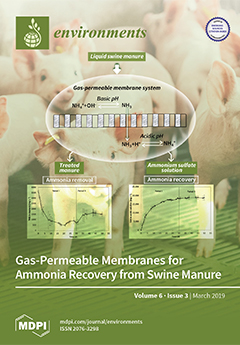
Cover Story (view full-size image): Reducing nitrogen content in swine manure could improve its management, optimizing land application while minimizing ammonia emissions and allowing its recovery as an ammonium salt fertilizer. In this study, ammonia was successfully removed and recovered from swine manure using a gas-permeable membrane system operated in semi-continuous mode. The recovery rate was uniform regardless of the total ammonia loading rate applied and the ammonia concentration in the reactor. View this paper.
  • Issues are regarded as officially published after their release is announced to the table of contents alert mailing list.
  • You may sign up for e-mail alerts to receive table of contents of newly released issues.
  • PDF is the official format for papers published in both, html and pdf forms. To view the papers in pdf format, click on the "PDF Full-text" link, and use the free Adobe Reader to open them.
Order results
Result details
Select all
Export citation of selected articles as:
13 pages, 7933 KiB  
Article
Challenges and Limitations of Karst Aquifer Vulnerability Mapping Based on the PaPRIKa Method—Application to a Large European Karst Aquifer (Fontaine de Vaucluse, France)
by Chloé Ollivier, Konstantinos Chalikakis, Naomi Mazzilli, Nerantzis Kazakis, Yoann Lecomte, Charles Danquigny and Christophe Emblanch
Environments 2019, 6(3), 39; https://doi.org/10.3390/environments6030039 - 26 Mar 2019
Cited by 12 | Viewed by 5544
Abstract
Aquifer vulnerability maps can improve groundwater management for sustainable anthropogenic development. The latest update of karst aquifer vulnerability mapping is named: the Protection of Aquifers base on Protection, Rock type, Infiltration and KArstification (PaPRIKa). This multi-criteria assessment method is based on a weighting [...] Read more.
Aquifer vulnerability maps can improve groundwater management for sustainable anthropogenic development. The latest update of karst aquifer vulnerability mapping is named: the Protection of Aquifers base on Protection, Rock type, Infiltration and KArstification (PaPRIKa). This multi-criteria assessment method is based on a weighting system whose criteria are selected according to the aquifer under study. In this study, the PaPRIKa method has been applied in the Fontaine de Vaucluse karst aquifer using the novel plugin for Quantum Geographic Information System (QGIS) software. The Fontaine de Vaucluse karst aquifer is the largest European karst hydrosystem with a catchment area that measures approximately 1162 km 2 . Four thematic maps were produced according to the criteria of protection, rock type, infiltration, and karst development. The plugin expedites the weighting system test and generates the final vulnerability map. At a large scale the vulnerability map is globally linked with primary geomorphological units and at the local scale is mostly affected by karst features that drive hydrodynamics. In conclusion, the novel QGIS plugin standardizes the application of the PaPRIKa method, saves time and prevents user omissions. The final vulnerability map provides useful contributions that are most relevant to groundwater managers and decision-makers. We highlight the sensibility of the vulnerability map to the weighting system and validation issues of the vulnerability map are raised. Full article
(This article belongs to the Special Issue Groundwater Quality and Groundwater Vulnerability Assessment)
Show Figures

Graphical abstract

11 pages, 1279 KiB  
Article
Carbon Footprint and Water Footprint of Electric Vehicles and Batteries Charging in View of Various Sources of Power Supply in the Czech Republic
by Simona Jursova, Dorota Burchart-Korol and Pavlina Pustejovska
Environments 2019, 6(3), 38; https://doi.org/10.3390/environments6030038 - 26 Mar 2019
Cited by 14 | Viewed by 7133
Abstract
In the light of recent developments regarding electric vehicle market share, we assess the carbon footprint and water footprint of electric vehicles and provide a comparative analysis of energy use from the grid to charge electric vehicle batteries in the Czech Republic. The [...] Read more.
In the light of recent developments regarding electric vehicle market share, we assess the carbon footprint and water footprint of electric vehicles and provide a comparative analysis of energy use from the grid to charge electric vehicle batteries in the Czech Republic. The analysis builds on the electricity generation forecast for the Czech Republic for 2015–2050. The impact of different sources of electricity supply on carbon and water footprints were analyzed based on electricity generation by source for the period. Within the Life Cycle Assessment (LCA), the carbon footprint was calculated using the Intergovernmental Panel on Climate Change (IPCC) method, while the water footprint was determined by the Water Scarcity method. The computational LCA model was provided by the SimaPro v. 8.5 package with the Ecoinvent v. 3 database. The functional unit of study was running an electric vehicle over 100 km. The system boundary covered an electric vehicle life cycle from cradle to grave. For the analysis, we chose a vehicle powered by a lithium-ion battery with assumed consumption 19.9 kWh/100 km. The results show that electricity generated to charge electric vehicle batteries is the main determinant of carbon and water footprints related to electric vehicles in the Czech Republic. Another important factor is passenger car production. Nuclear power is the main determinant of the water footprint for the current and future electric vehicle charging, while, currently, lignite and hard coal are the main determinants of carbon footprint. Full article
(This article belongs to the Special Issue Advances in Environmental Engineering II)
Show Figures

Figure 1

2 pages, 565 KiB  
Correction
Correction: Alsina-Pagès et al. Noise Events Monitoring for Urban and Mobility Planning in Andorra la Vella and Escaldes-Engordany. Environments, 2019, 6, 24
by Rosa Ma Alsina-Pagès, Robert Garcia Almazán, Marc Vilella and Marc Pons
Environments 2019, 6(3), 37; https://doi.org/10.3390/environments6030037 - 18 Mar 2019
Viewed by 3576
Abstract
The authors would like to correct the published article [...] Full article
(This article belongs to the Special Issue New Solutions Mitigating Environmental Noise Pollution)
Show Figures

Figure 1

17 pages, 9946 KiB  
Article
A Statistical and Spatial Analysis of Portuguese Forest Fires in Summer 2016 Considering Landsat 8 and Sentinel 2A Data
by Ana Teodoro and Ana Amaral
Environments 2019, 6(3), 36; https://doi.org/10.3390/environments6030036 - 16 Mar 2019
Cited by 46 | Viewed by 7589
Abstract
Forest areas in Portugal are often affected by fires. The objective of this work was to analyze the most fire-affected areas in Portugal in the summer of 2016 for two municipalities considering data from Landsat 8 OLI and Sentinel 2A MSI (prefire and [...] Read more.
Forest areas in Portugal are often affected by fires. The objective of this work was to analyze the most fire-affected areas in Portugal in the summer of 2016 for two municipalities considering data from Landsat 8 OLI and Sentinel 2A MSI (prefire and postfire data). Different remote sensed data-derived indices, such as Normalized Difference Vegetation Index (NDVI) and Normalized Burn Ratio (NBR), could be used to identify burnt areas and estimate the burn severity. In this work, NDVI was used to evaluate the area burned, and NBR was used to estimate the burn severity. The results showed that the NDVI decreased considerably after the fire event (2017 images), indicating a substantial decrease in the photosynthesis activity in these areas. The results also indicate that the NDVI differences (dNDVI) assumes the highest values in the burned areas. The results achieved for both sensors regarding the area burned presented differences from the field data no higher than 13.3% (for Sentinel 2A, less than 7.8%). We conclude that the area burned estimated using the Sentinel 2A data is more accurate, which can be justified by the higher spatial resolution of this data. Full article
(This article belongs to the Special Issue Application of Remote Sensing and GIS in Environmental Studies)
Show Figures

Figure 1

15 pages, 2996 KiB  
Article
Occupational Fine/Ultrafine Particles and Noise Exposure in Aircraft Personnel Operating in Airport Taxiway
by Gabriele Marcias, Maria Francesca Casula, Michele Uras, Andrea Falqui, Edoardo Miozzi, Elisa Sogne, Sergio Pili, Ilaria Pilia, Daniele Fabbri, Federico Meloni, Marco Pau, Andrea Maurizio Sanna, Jacopo Fostinelli, Giorgio Massacci, Ernesto D’Aloja, Francesca Larese Filon, Marcello Campagna and Luigi Isaia Lecca
Environments 2019, 6(3), 35; https://doi.org/10.3390/environments6030035 - 15 Mar 2019
Cited by 12 | Viewed by 5335
Abstract
The occupational exposure to airborne fine and ultrafine particles (UFPs) and noise in aircraft personnel employed in airport taxiway was investigated. Stationary samplings and multiple personal sampling sites and job tasks were considered. Size distribution, particle number concentrations, lung dose surface area were [...] Read more.
The occupational exposure to airborne fine and ultrafine particles (UFPs) and noise in aircraft personnel employed in airport taxiway was investigated. Stationary samplings and multiple personal sampling sites and job tasks were considered. Size distribution, particle number concentrations, lung dose surface area were measured by personal particle counters and by means of an electric low pressure impactor (ELPI+TM). Morphological and chemical characterization of UFPs were performed by transmission and scanning electron microscopy, the latter together with energy dispersive X-Ray spectroscopy based spatially resolved compositional mapping. A-weighted noise exposure level A-weighted noise exposure level normalized to an 8 h working day and Peak Sound C-weighted Pressure Level was calculated for single worker and for homogeneous exposure groups. Our study provides evidence on the impact of aviation-related emissions on occupational exposure to ultrafine particles and noise exposure of workers operating in an airport taxiway. Main exposure peaks are related to pre-flight operations of engine aircrafts. Although exposure to ultrafine particles and noise appears to not be critical if compared with other occupational scenarios, the coincidence in time of high peaks of exposure to ultrafine particles and noise suggest that further investigations are warranted in order to assess possible subclinical and clinical adverse health effects in exposed workers, especially for cardiovascular apparatus. Full article
Show Figures

Graphical abstract

19 pages, 10787 KiB  
Article
Impact of Recreational Activities on an Unmanaged Alpine Campsite: The Case of Kuro-Dake Campsite, Daisetsuzan National Park, Japan
by Ting Wang and Teiji Watanabe
Environments 2019, 6(3), 34; https://doi.org/10.3390/environments6030034 - 15 Mar 2019
Cited by 8 | Viewed by 6652
Abstract
The Kuro-dake Campsite in Daisetsuzan National Park is situated in a fragile alpine setting. Since it opened in 1992, it has not been under formal management. With camping increasingly affecting the Kuro-dake Campsite, this study aims to gain deeper insights into the soil [...] Read more.
The Kuro-dake Campsite in Daisetsuzan National Park is situated in a fragile alpine setting. Since it opened in 1992, it has not been under formal management. With camping increasingly affecting the Kuro-dake Campsite, this study aims to gain deeper insights into the soil erosion and overcrowding at the campsite and to suggest a corresponding strategy for future management. A detailed topographic map was created using pole photogrammetry to understand the ground surface condition of the campsite in 2017. Aerial photographs taken in 2012 and 2017 were used to understand the long-term changes in the ground surface. Furthermore, questionnaire surveys with campers, interview surveys with organizations related to the park management and secondary data collection were conducted. Two gullies were identified on the topographic map of the campsite. From 2012 to 2017, the campsite size increased by 48 m2. The daily-use level on busy days is nearly seven times the mean daily-use level for the year. Some campers illegally pitch tents on nearby trails on such busy days. The questionnaire surveys in 2017 and 2018 (n = 346) show that most respondents oppose a future closure of the campsite and two-thirds oppose a use limit. The 2018 survey (n = 210) shows that 71% of respondents were not aware of the reservation system in national parks elsewhere; however, 76% agreed to a reservation system to secure their tent space. Introducing formal management oversight, along with a reservation system, is urgently needed. Full article
Show Figures

Figure 1

19 pages, 3590 KiB  
Article
System to Evaluate Movement of Biological Contaminants in Soil
by Matthew R. Miller, Nora H. Onstad, Michelle L. Green, William H. Witola and Paul C. Davidson
Environments 2019, 6(3), 33; https://doi.org/10.3390/environments6030033 - 08 Mar 2019
Viewed by 4481
Abstract
Soil columns have been utilized in hydrology to study vertical solute transfer through porous material for decades. Soil columns are typically designed as open tubes with soil held in place with meshing. While this open design is sufficient for non-hazardous particles, it is [...] Read more.
Soil columns have been utilized in hydrology to study vertical solute transfer through porous material for decades. Soil columns are typically designed as open tubes with soil held in place with meshing. While this open design is sufficient for non-hazardous particles, it is not ideal for hazardous biological contaminants that may be harmful to humans. The design of this study features a closed soil column system for use with potentially hazardous biological components. The apparatus is comprised of a mist nozzle, flow-reducing cap, and meshing to simulate rainfall on each soil column. After percolating through the soil, water and contaminants pass through a funnel coupling and discharge tube into a collection container. For additional safety, the soil column design fits within a standard biosafety cabinet for use with hazardous contaminants. Its modular design allows for simple maintenance, water flowrate adjustment, and versatility that encourages use in multiple applications. These soil columns were created to study the vertical flow of pathogens, pesticides, and other biological agents. Further experimentation with various hazardous components will develop a better understanding of their fate and transport in soil. This paper details the construction processes and testing methods to validate the system’s ability to replicate a desired flowrate, which is a precursor to studying the vertical transport of pathogens and other agents through soil. Full article
Show Figures

Figure 1

13 pages, 1365 KiB  
Article
Application of Gas-Permeable Membranes For-Semi-Continuous Ammonia Recovery from Swine Manure
by Berta Riaño, Beatriz Molinuevo-Salces, Matías B. Vanotti and María Cruz García-González
Environments 2019, 6(3), 32; https://doi.org/10.3390/environments6030032 - 06 Mar 2019
Cited by 31 | Viewed by 6038
Abstract
Gas-permeable membrane technology is a new strategy to minimize ammonia losses from manure, reducing pollution and recovering N in the form of an ammonium salt fertilizer. In this work, a new operational configuration to recover N using the gas-permeable membrane technology from swine [...] Read more.
Gas-permeable membrane technology is a new strategy to minimize ammonia losses from manure, reducing pollution and recovering N in the form of an ammonium salt fertilizer. In this work, a new operational configuration to recover N using the gas-permeable membrane technology from swine manure was tested in a semi-continuous mode. It treated swine manure with a total ammonia nitrogen (TAN) concentration of 3451 mg L−1. The system was operated with low aeration rate (to raise pH), and with hydraulic retention times (HRT) of seven days (Period I) and five days (Period II) that provided total ammonia nitrogen loading rate (ALR) treatments of 491 and 696 mg TAN per L of reactor per day, respectively. Results showed a uniform TAN recovery rate of 27 g per m2 of membrane surface per day regardless of the ALR applied and the manure TAN concentration in the reactor. TAN removal reached 79% for Period I and 56% for Period II, with 90% of recovery by the membrane in both periods. Water capture in the acidic solution was also uniform during the experimental period. An increase in temperature of 3 °C of the acidic solution relative to the wastewater reduced 34% the osmotic distillation and water dilution of the product. These results suggested that the gas-permeable membrane technology operating in a semi-continuous mode has a great potential for TAN recovery from manure. Full article
Show Figures

Graphical abstract

19 pages, 6633 KiB  
Article
Noise Assessment of Small Vessels for Action Planning in Canal Cities
by Marco Bernardini, Luca Fredianelli, Francesco Fidecaro, Paolo Gagliardi, Marco Nastasi and Gaetano Licitra
Environments 2019, 6(3), 31; https://doi.org/10.3390/environments6030031 - 05 Mar 2019
Cited by 46 | Viewed by 6271
Abstract
After the European Environmental Noise Directive prescribed noise maps and action plans, wide scientific literature and a consistent number of mitigation strategies emerged for road, railway, airport, and industrial noise. Unfortunately, very little attention has been paid to the noise produced by ports [...] Read more.
After the European Environmental Noise Directive prescribed noise maps and action plans, wide scientific literature and a consistent number of mitigation strategies emerged for road, railway, airport, and industrial noise. Unfortunately, very little attention has been paid to the noise produced by ports in their surroundings, even though there could be many areas affected by it. At present, more attention seems to be paid to noise produced underwater, mostly for military and security reasons and for its interference with wildlife, rather than airborne noise and its influence on human health. In the framework of a project aiming to shed more light on a topic so far under-investigated, this paper presents an acoustical characterization of different small vessels at various speeds that move around on a daily basis in every type of port, produced by means of short- and long-term measurements. The new information acquired was used to produce a map of noise generated by vessels moving in Livorno’s canals, which branch off in a densely inhabited area. The simulations were validated using long-term measurement. The number of citizens exposed was also estimated and used to calculate the number of highly annoyed people according to the recent curve for road traffic noise proposed by Guski et al. In order to prevent citizen exposure to noise and possible complaints about small boats, different scenarios and possible future situations such as various vessel speeds, limited flow, restricted areas for some categories, or new residential areas were studied. Full article
(This article belongs to the Special Issue New Solutions Mitigating Environmental Noise Pollution)
Show Figures

Figure 1

22 pages, 10248 KiB  
Article
Mapping Forest Fire Risk at a Local Scale—A Case Study in Andalusia (Spain)
by Ismael Vallejo-Villalta, Estefanía Rodríguez-Navas and Joaquín Márquez-Pérez
Environments 2019, 6(3), 30; https://doi.org/10.3390/environments6030030 - 02 Mar 2019
Cited by 19 | Viewed by 6683
Abstract
Forest fires are a critical environmental problem facing current societies, with serious repercussions at ecological, economic and personal safety levels. Detailed maps enabling identification of areas liable to be affected is an indispensable first step allowing different prevention and protection measures vis-à-vis this [...] Read more.
Forest fires are a critical environmental problem facing current societies, with serious repercussions at ecological, economic and personal safety levels. Detailed maps enabling identification of areas liable to be affected is an indispensable first step allowing different prevention and protection measures vis-à-vis this kind of phenomenon. These maps could be especially valuable for use in land management and emergency planning at a municipality scale. A methodology is shown for producing local maps of mid- and short-term forest fire risk, integrating both natural and human factors. Among natural factors, variables normally used in hazard models are considered as fuel models, slopes or vegetation moisture stress. From the human perspective, more novel aspects have been evaluated, meant either to assess human-induced hazard (closeness to forestland of causative elements or the ability of people to penetrate the forest environment), or to assess vulnerability, considering the population’s location in urban centres and scattered settlements. The methodology is applied in a municipality of Andalusia (Spain) and obtained results were compared to burned areas maps. Full article
Show Figures

Figure 1

19 pages, 3161 KiB  
Article
Fractal and Long-Memory Traces in PM10 Time Series in Athens, Greece
by Dimitrios Nikolopoulos, Konstantinos Moustris, Ermioni Petraki, Dionysios Koulougliotis and Demetrios Cantzos
Environments 2019, 6(3), 29; https://doi.org/10.3390/environments6030029 - 26 Feb 2019
Cited by 24 | Viewed by 4895
Abstract
This work examines if chaos and long memory exist in PM10 concentrations recorded in Athens, Greece. The algorithms of Katz, Higuchi, and Sevcik were employed for the calculation of fractal dimensions and Rescaled Range (R/S) analysis for the calculation of the Hurst [...] Read more.
This work examines if chaos and long memory exist in PM10 concentrations recorded in Athens, Greece. The algorithms of Katz, Higuchi, and Sevcik were employed for the calculation of fractal dimensions and Rescaled Range (R/S) analysis for the calculation of the Hurst exponent. Windows of approximately two months’ duration were employed, sliding one sample forward until the end of each utilized signal. Analysis was applied to three long PM10 time series recorded by three different stations located around Athens. Analysis identified numerous dynamical complex fractal time-series segments with patterns of long memory. All these windows exhibited Hurst exponents above 0.8 and fractal dimensions below 1.5 for the Katz and Higuchi algorithms, and 1.2 for the Sevcik algorithm. The paper discusses the importance of threshold values for the postanalysis of the discrimination of fractal and long-memory windows. After setting thresholds, computational calculations were performed on all possible combinations of two or more techniques for the data of all or two stations under study. When all techniques were combined, several common dates were found for the data of the two combinations of two stations. When the three techniques were combined, more common dates were found if the Katz algorithm was not included in the meta-analysis. Excluding Katz’s algorithm, 12 common dates were found for the data from all stations. This is the first time that the results from sliding-window chaos and long-memory techniques in PM10 time series were combined in this manner. Full article
Show Figures

Figure 1

12 pages, 950 KiB  
Article
Long-Term Effects of Mercury on Biofilms Grown in Contaminated Microcosms: A Pilot Study
by Perrine Dranguet, Aline Freiburghaus, Vera I. Slaveykova and Séverine Le Faucheur
Environments 2019, 6(3), 28; https://doi.org/10.3390/environments6030028 - 26 Feb 2019
Cited by 1 | Viewed by 4458
Abstract
Biofilms are important components of the mercury (Hg) biogeochemical cycle. However, Hg effects on biofilm communities are overlooked. Here, we present results of a pilot study on the chronic effects of Hg on biofilms, notably on the potential change of their taxonomic composition. [...] Read more.
Biofilms are important components of the mercury (Hg) biogeochemical cycle. However, Hg effects on biofilm communities are overlooked. Here, we present results of a pilot study on the chronic effects of Hg on biofilms, notably on the potential change of their taxonomic composition. Biofilms were cultivated in microcosms enriched with three different Hg concentrations (11 ± 2 pM, 121 ± 9 pM and 1454 ± 54 pM) for 55 days and examined for their accumulated Hg concentrations and composition. Bioaccumulated Hg concentrations were representative of those encountered in natural environments. Despite the lack of influence on the ash free dry weight and chlorophyll content, the surface coverage of the substrata of biofilms grown in Hg decreased. Algal community were strongly affected by Hg, with a decrease in their richness with Ochrophyta found as the most sensitive phyla. The diversity and richness of bacterial communities did not change upon cultivation in Hg but the presence of Proteobacteria increased with Hg, whereas Bacteroidetes, Actinobacteria, Verrumicrobia, and Cyanobacteria were negatively impacted. Overall, the above findings suggest that the examination of the algal community composition might be used as a potential biomonitoring tool to assess the impacts of environmental Hg concentrations on aquatic systems, which would merit further investigation. Full article
(This article belongs to the Special Issue Aquatic Microbial Ecotoxicology)
Show Figures

Figure 1

22 pages, 1217 KiB  
Article
DEUFRABASE: A Simple Tool for the Evaluation of the Noise Impact of Pavements in Typical Road Geometries
by Michel Bérengier, Judicaël Picaut, Bettina Pahl, Denis Duhamel, Benoit Gauvreau, Markus Auerbach, Peter Gusia and Nicolas Fortin
Environments 2019, 6(3), 27; https://doi.org/10.3390/environments6030027 - 26 Feb 2019
Cited by 1 | Viewed by 4794
Abstract
Traffic noise is considered by people as one of the most important sources of environmental discomfort. A way to limit the traffic noise is to reduce the noise emission, for example, by using specific low noise pavements, particularly in suburban areas. However, in [...] Read more.
Traffic noise is considered by people as one of the most important sources of environmental discomfort. A way to limit the traffic noise is to reduce the noise emission, for example, by using specific low noise pavements, particularly in suburban areas. However, in real situations, it can be difficult to evaluate the impact of a given pavement, because it depends, for example, on the road geometry, the meteorological conditions, or the distance of the receiver position. Finally it can be difficult to select the most appropriate pavement for a given noise reduction objective. In this paper, a simple method is proposed to evaluate the noise impact of a pavement, in typical road geometries and environmental conditions. The proposed approach uses two databases, the first one based on measurements of emission spectra of road vehicles on several typical pavements, the second one made of pre-calculations of noise propagation for typical road configurations. Finally, the method is implemented in an interactive web tool, called DEUFRABASE, which allows one to obtain a fast estimation of the L Aeq (1 h or 24 h) and L den noise levels for various pavements and road configurations, as functions of the traffic flow and composition. By comparing the method with measurements, it is showed that the tool, although based on a restricted number of pavements and on several simplifications, can predict the noise impact of typical road configurations, with an acceptable error, most often less than 2 dB. Full article
(This article belongs to the Special Issue New Solutions Mitigating Environmental Noise Pollution)
Show Figures

Figure 1

Previous Issue
Next Issue
Back to TopTop