Article

Impact of Recreational Activities on an Unmanaged Alpine Campsite: The Case of Kuro-Dake Campsite, Daisetsuzan National Park, Japan

1
Graduate School of Environmental Science, Hokkaido University, Sapporo, Hokkaido 060-0810, Japan
2
Faculty of Environmental Earth Science, Hokkaido University, Sapporo, Hokkaido 060-0810, Japan
*
Author to whom correspondence should be addressed.
Environments 2019, 6(3), 34; https://doi.org/10.3390/environments6030034
Submission received: 26 February 2019 / Revised: 8 March 2019 / Accepted: 11 March 2019 / Published: 15 March 2019

Abstract

:
The Kuro-dake Campsite in Daisetsuzan National Park is situated in a fragile alpine setting. Since it opened in 1992, it has not been under formal management. With camping increasingly affecting the Kuro-dake Campsite, this study aims to gain deeper insights into the soil erosion and overcrowding at the campsite and to suggest a corresponding strategy for future management. A detailed topographic map was created using pole photogrammetry to understand the ground surface condition of the campsite in 2017. Aerial photographs taken in 2012 and 2017 were used to understand the long-term changes in the ground surface. Furthermore, questionnaire surveys with campers, interview surveys with organizations related to the park management and secondary data collection were conducted. Two gullies were identified on the topographic map of the campsite. From 2012 to 2017, the campsite size increased by 48 m2. The daily-use level on busy days is nearly seven times the mean daily-use level for the year. Some campers illegally pitch tents on nearby trails on such busy days. The questionnaire surveys in 2017 and 2018 (n = 346) show that most respondents oppose a future closure of the campsite and two-thirds oppose a use limit. The 2018 survey (n = 210) shows that 71% of respondents were not aware of the reservation system in national parks elsewhere; however, 76% agreed to a reservation system to secure their tent space. Introducing formal management oversight, along with a reservation system, is urgently needed.

1. Introduction

In national parks around the world, a park authority manages the places where campers can pitch tents, called “campgrounds” in this paper. The target of this study, however, are the unmanaged areas, called “campsites” in this paper.
National park managers face the dilemma of protecting natural resources from human impact while providing recreational opportunities to visitors. Recreational use of public lands and campgrounds inevitably causes resource degradation, which can affect the ecosystem and compromise the quality of visitor experiences [1,2,3]. Compared to trails, campsites/campgrounds are places where campers congregate and spend a large portion of their trips. Camping not only intensively affects the resource conditions on each individual site but also extensively affects them through site expansion and proliferation [4,5,6]. Changes in the areal extent of impacts on established campgrounds tend to be more obvious than changes in the intensity of impacts over time [7]. For example, the impacted area of a campground increased significantly because of site expansion while the percentage of vegetation cover remained relatively stable [7]. Previous studies have also reported that frequent trampling on campgrounds causes loss of vegetation cover and organic soil horizon even with low use [8,9,10]. The continuous trampling makes the exposed mineral soil highly compact, which reduces rainfall infiltration and causes further soil erosion [11].
Therefore, studies have discussed the significance of a proper management strategy along with a periodic monitoring system from an early stage [12,13]. Concentrating use on designated campgrounds while dispersing use on sites in primitive wilderness areas with extremely low visitation rates is widely practiced in American national parks and other protected areas and has significantly minimized the impact of camping activities [14,15,16,17]. Although limiting use to a few designated sites significantly prevents the formation of new sites and reduces the total number of existing sites, this strategy is not always successful [15,17].
Both short- and long-term assessments of camping impacts and the effectiveness of management actions have been conducted with diverse impact indicators to refine the management strategy and to promote understanding of changes on campgrounds [15,18,19,20,21]. The commonly measured indicators include area of site, area of bare ground and depth of eroded soil. There are four traditional methods of areal measurement—a categorical size estimation, the fixed radial transect method, the variable radial transect method and the geometric figure method [22]. In recent years, a new method involving the measurement of areas on hand-held GPS devices has emerged in environmental research [23,24].
Sakamoto [25] quantified the expansion of bare ground on the old Kuro-dake Campsite (closed in 1992) in Daisetsuzan National Park (DNP) from 1945 to 1990 using aerial photographs. One common approach used in previous studies for the measurement of soil erosion at the campsite was photogrammetry mapping with aerial photographs [26]. However, the resolution was not high enough to identify changes over a short period. The latest method, called pole photogrammetry, obtains fast and accurate surface mapping that improves the monitoring of geomorphic changes [27,28,29].
Some studies have evaluated the effectiveness of management actions from the perspective of campers through social surveys, such as a questionnaire survey [12,30,31]. A study [12] conducted on campgrounds in Warren National Park, western Australia, reported campers’ perceptions of existing conditions and management preferences through a social survey. The approach of collecting questionnaires after completion was deemed preferable to mail-back surveys because of accurate recall and higher response rate [12]. Another study [30] conducted a questionnaire survey on campers’ opinions of campground conditions and management measures on the highly impacted Appalachian Trail camping area. The results indicate that visitors were generally satisfied with the camping indicators, both before and after the changes.
In most national parks of Japan, campgrounds serve as part of the managed facilities, with different strategies for different vulnerability and usage levels of the natural environment [32]. For example, in DNP, there are nine campgrounds at the foot of the mountains or lower altitudes, which are managed by different administrative offices [33]. According to the “Park Plan,” at higher altitudes, there are no formally managed campgrounds, whereas 12 designated places—called yaeishiteichi in Japanese as distinct from managed campgrounds—provide camping opportunities sans management. The decisions regarding necessary actions are made through consensus of related administrations, including the Ministry of the Environment, the Ministry of Agriculture, Forestry and Fisheries, the Hokkaido government and local governments. The staff of these administrations cooperate with each other to stop campers from camping outside the designated places. At a few campsites, park volunteers help set ropes around the sites to avoid the expansion of bare ground [33]. However, no efforts have been taken to sustain the site conditions and ensure a high-quality experience for campers.
After long-term use, grave gully erosion and crowding problems on the old Kuro-dake Campsite had compromised the quality of visitor experience [25]. Further, it was demonstrated that soil erosion on the old site continued even six years after its closure [26]. No studies, however, have been conducted in relation to the current Kuro-dake Campsite. This study aims to explore the impacts of recreational activities on the current Kuro-dake Campsite and suggest a possible management strategy for the future.

2. Materials and Methods
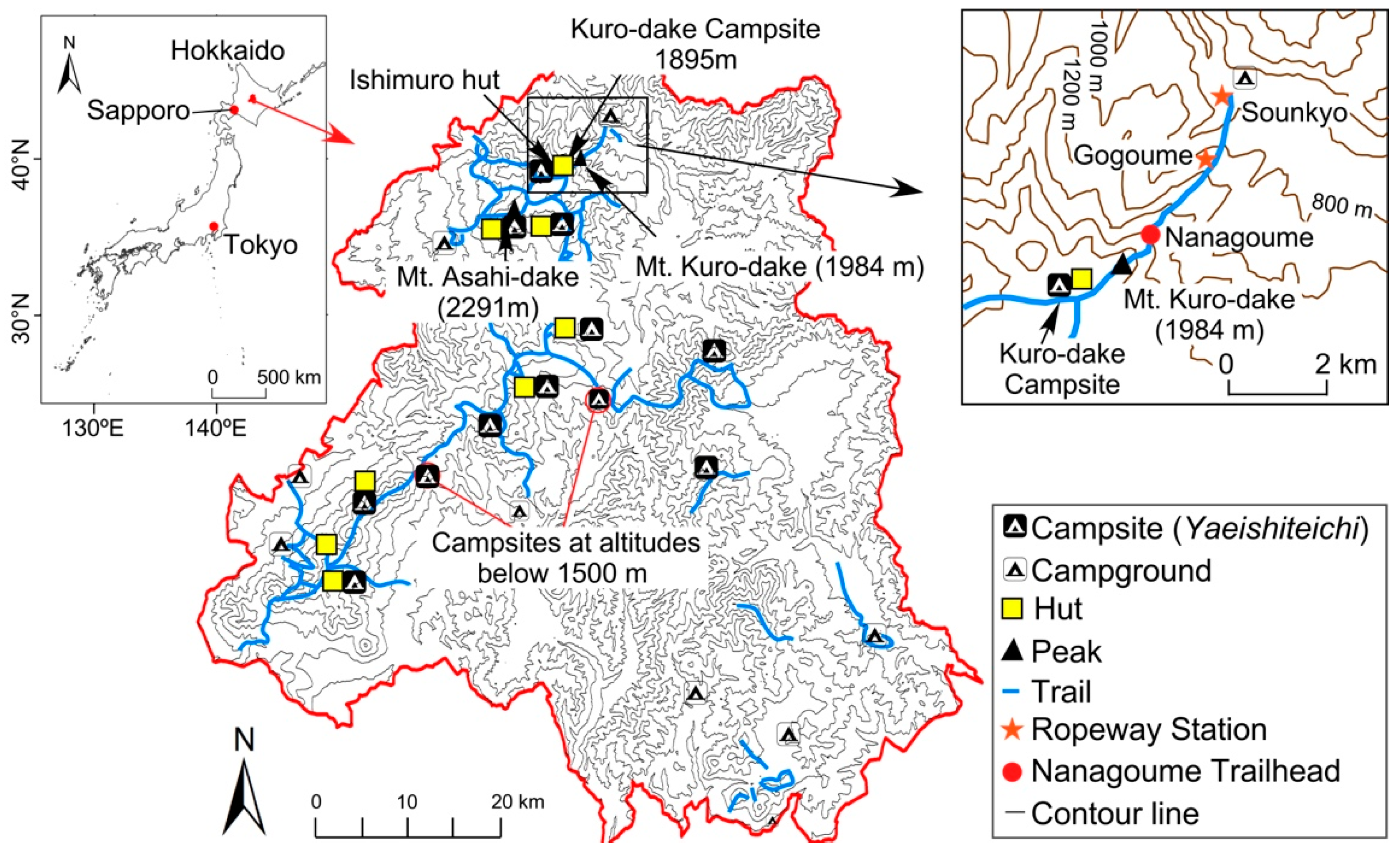
2.1. Study Area

DNP, the largest national park in Japan with an area of 236,764 hectares, is located in central Hokkaido (Figure 1). It consists of dozens of mountain peaks, 2000 m in altitude. The highest peak is Mt. Asahi-dake (2291 m). Areas higher than approximately 1500 m are classified as an alpine zone with alpine flora. The main recreational facilities include hiking/trekking trails (a total length of about 300 km), 8 huts, 12 campsites and 9 campgrounds. All huts are for emergency use, except for the Ishimuro and Hakuun-dake huts (Figure 1), which are manned huts and serve as overnight stay facilities from late June to late September. The current Kuro-dake Campsite is located at an altitude of 1895 m (43°41′43″ N, 142°54′40″ E), about 0.8 km southwest of the peak of Mt. Kuro-dake (1984 m). The current site has been used since 1992. The old site is located at an altitude of 1878 m, northeast of the Ishimuro hut.
The current campsite is adjacent to the Ishimuro hut (Figure 2) and the boundary of the current campsite is demarcated with a white rope fixed on some rods to separate the camping space from surrounding vegetation cover. Much of the ground surface at the current campsite lacks vegetation cover and organic litter. Further, there is obvious evidence of soil erosion on the current site because the ground surface of the adjacent undisturbed area covered by the dense Pinus pumila and other alpine plants is higher. The campsite here is a free site, within which campers can pitch their tents anywhere. The area of the current campsite is around 394 m2 and is just one-third the size of the old campsite (about 1338 m2). There are facilities, such as a water tank filled with rain water, composting toilet and picnic tables available for campers. Visitors who camp here pay ¥500 (US $4.5) per person per night as a “donation” fee.
One of the features of this campsite is good access. Visitors can take the ropeway from the foot of the mountain (Sounkyo Ropeway Station) to ascend around 600 m in 7 min to the Gogoume Ropeway Station (Figure 1). They can then take a chairlift to the Nanagoume trailhead at an altitude of 1531 m. Visitors arrive at the current Kuro-dake Campsite after a roughly 1.5-h trek from the Nanagoume trailhead. This easy access has enabled the campsite to become one of the most popular campsites among both experienced and beginner trekkers in DNP as seen from the overcrowding in Figure 3a,b.

2.2. Methods

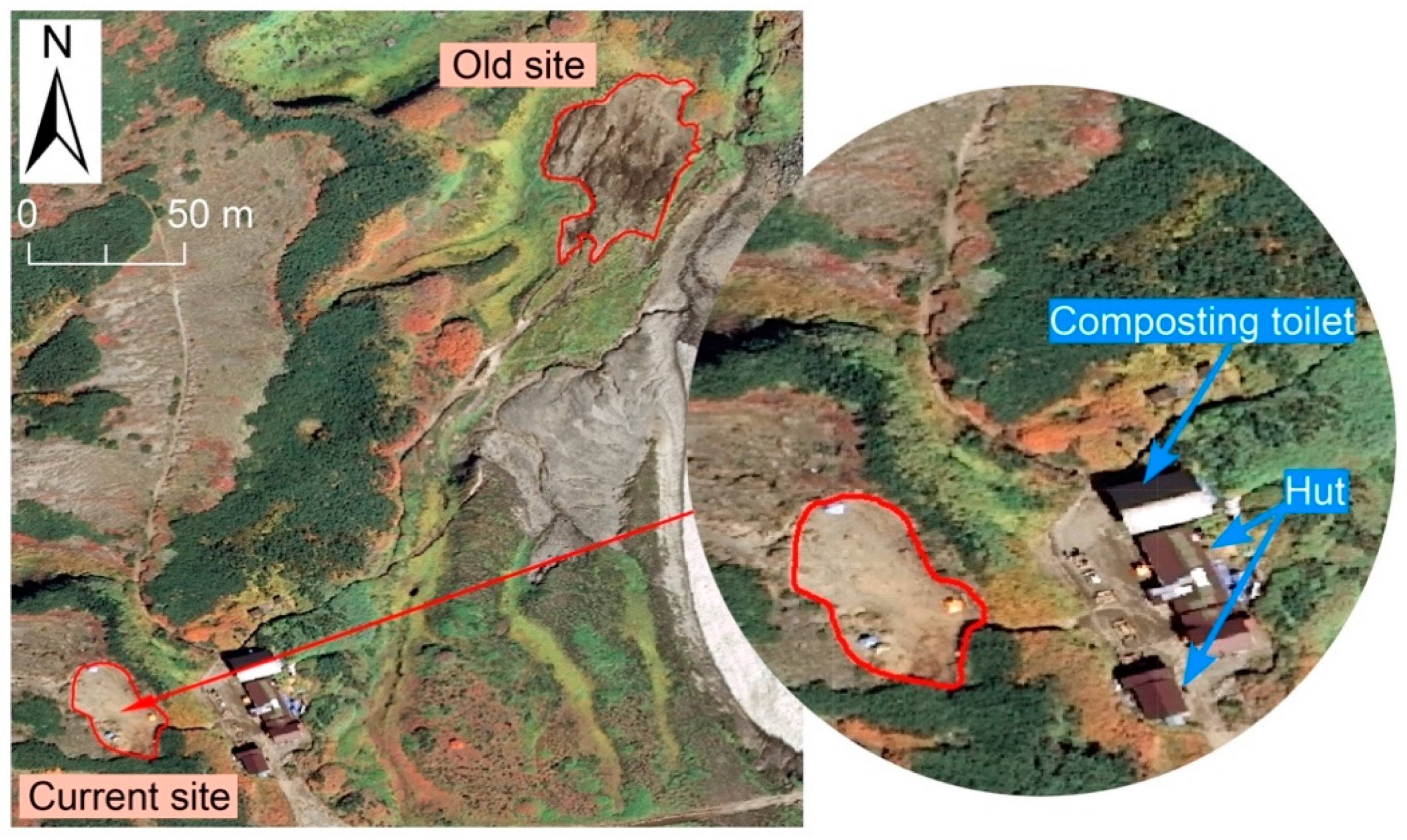
2.2.1. Changes in the Area of the Current Campsite

Aerial photographs from the previous years (1997, 2007, 2012 and 2017) reveal an obvious expansion of the current campsite between 2012 and 2017. Therefore, the aerial photographs of 2012 and 2017 were georeferenced using Arc GIS 10.2 to quantify the areal expansion. The coordinate system of “WGS1984, UTMZone54N” was used for spatial reference. Since surface changes in mountain areas are complex, a third-order polynomial transformation was conducted to correct the distortion. For each aerial photograph, 16 coordinate points were added to reach the ideal accuracy. With the two georeferenced aerial photographs, two polygon files representing the current campsites of 2012 and 2017 were created. Then, the areas of the current campsite from 2012 and 2017 were calculated using the geometry calculation function. In this study, the boundary of the campsite was drawn along the clear edge of vegetation cover easily recognizable through the aerial colour photographs. There are some small separated “islands” with vegetation cover at the campsite. These “vegetation islands” were excluded from the measurement of the campsite area.

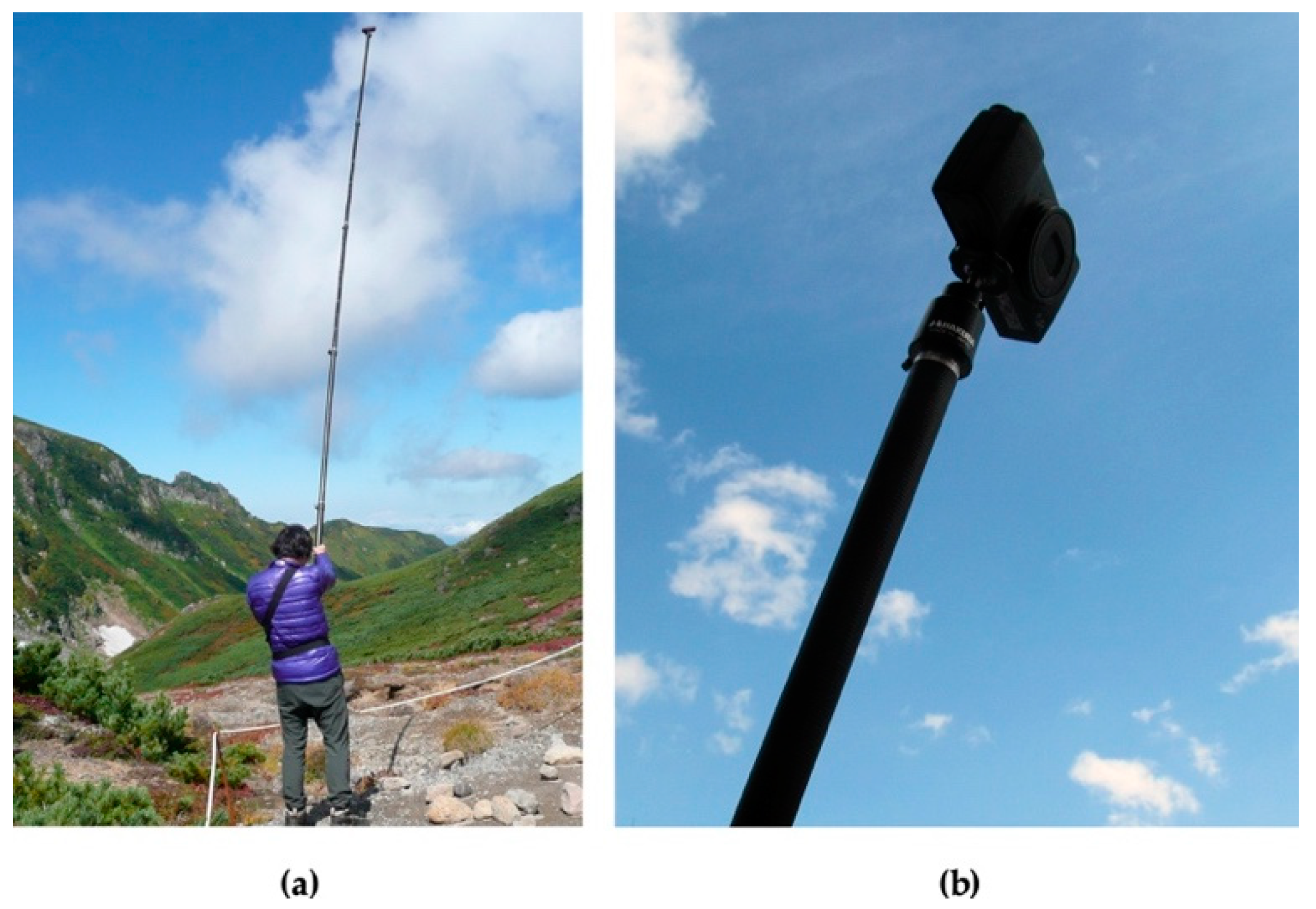
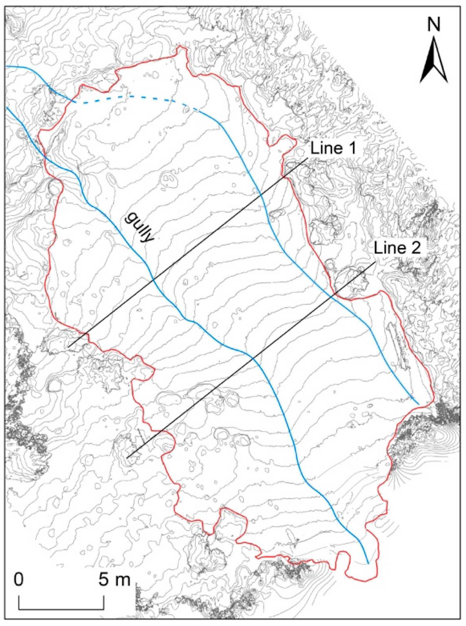
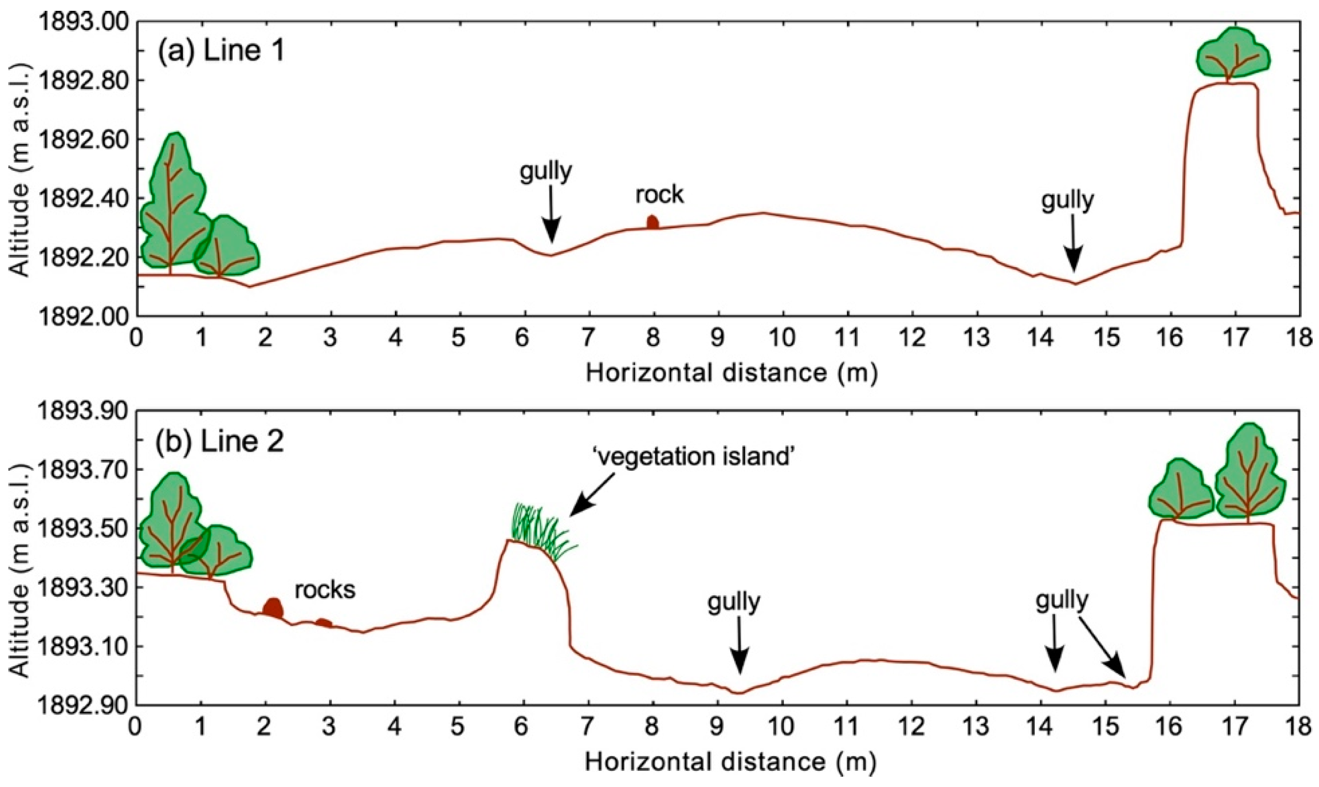
2.2.2. Detailed Topographic (Contour Line) Mapping

Photographs of the current campsite were taken from different directions with a digital camera (RICOH GR) mounted on a 4-m long pole (Figure 4), as done in recent studies [27,28,29]. The camera was connected to a smartphone application through Wi-Fi. The operator can see the images captured on the smartphone screen. The camera was positioned around 5 m above ground (a 4-m long pole on a 1-m high waist belt). The desirable overlap of photographs was achieved with a separation of less than 1 m between consecutive photos. Nearly 400 photographs of the current campsite were taken from various directions in September 2017 to obtain adequate multi-stereo viewing.
Furthermore, to obtain the precise orientation of each image, coordinate and elevation, data from nine ground controlling points (GCPs) were recorded on the current site with a global navigation satellite system receiver (Trimble Geo 7X, Nikon-Trimble, Tokyo, Japan). The 3D model was created by Structure-from-Motion (SfM) using Agisoft PhotoScan using the photographs taken by the pole-mounted camera in 2017. A relative orientation process called “image alignment” was completed after optimizing the orientation with the GCPs. A dense point cloud with depth information was reconstructed based on the estimated positions of each camera. Then, a high-resolution digital elevation model (DEM) (accuracy: 1 cm) was generated. The topographic map (contour intervals: 10 cm) depicting the detailed surface topography was created with the DEM using ArcGIS 10.2. The profiles of the ground surface were drawn to understand the surface topography, including the locations of gullies.

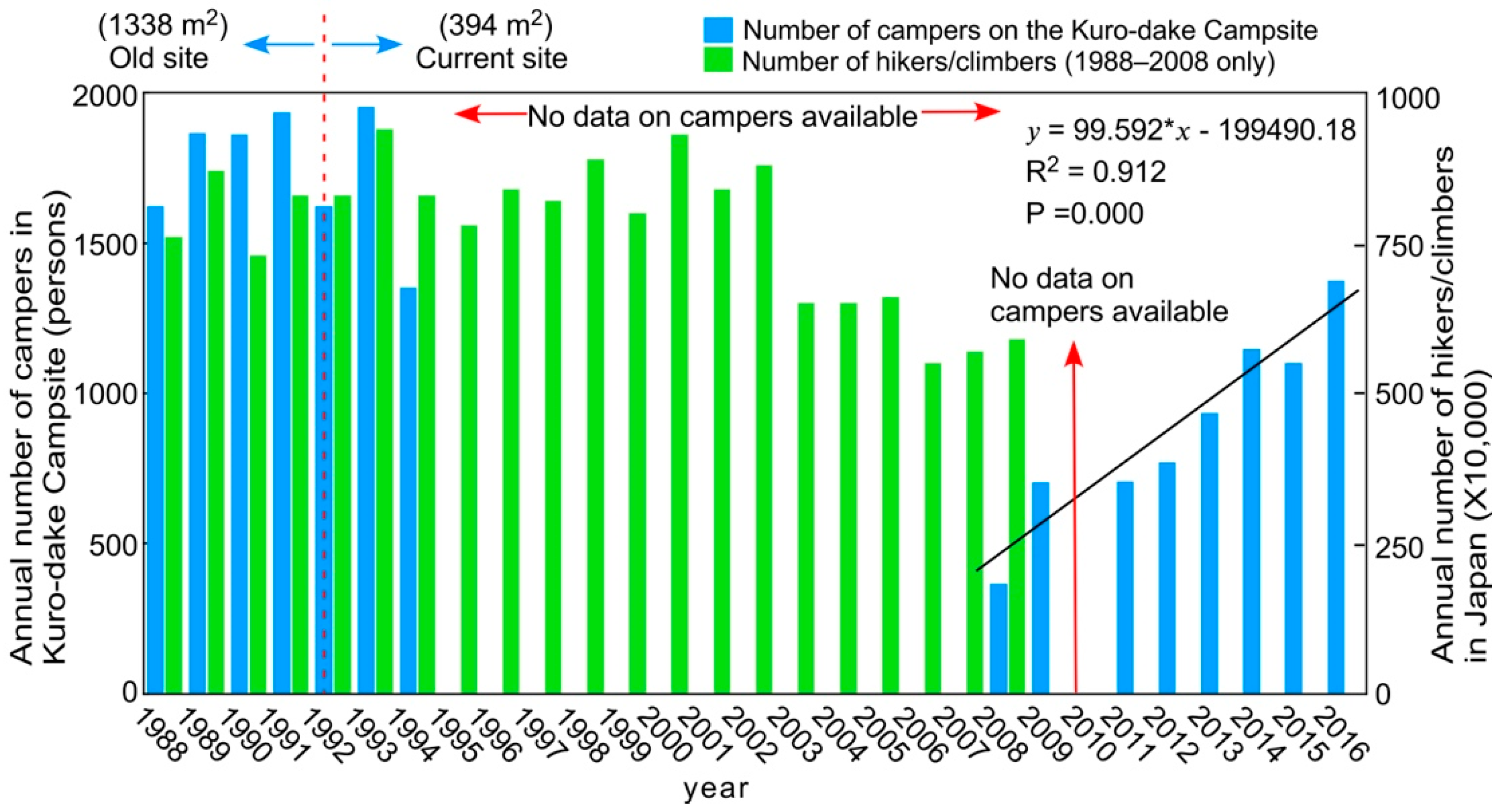
2.2.3. Analyses of the Number of Campers and Campsite Situation

This study used unpublished data of the annual changes in the number of campers in the last few years to indicate the annual use level of the Kuro-dake Campsite. Furthermore, unpublished data, recorded by the former managers of the Ishimuro hut and the ropeway company, indicating the number of campers per night in recent years (2013, 2015 and 2016) were obtained to explore the use level on busy days. The data for 2017 and 2018 were collected from the hut managers, as the campers need to register and pay a compulsory “donation” fee at the Ishimuro hut. The registration information includes the number of people in each group and the number of tents that each group pitched. Additionally, the tent-site selection by campers was recorded during the field work in 2017 and 2018, especially the number of surplus tents on busy days.
An onsite census of all the tents was conducted each night, including the tents of campers who were not interviewed.
The base maps of the current campsite with tents inside were also created. The coordinate system and the scale of the base map were based on the orthophoto of the aerial photograph of 2017. The locations of the tents were referred to in the photographs taken on site.

2.2.4. Questionnaire Survey

This study also conducted face-to-face questionnaire surveys with campers during the summers (between July and September) of 2017 and 2018. The surveys were conducted after the campers finished their camping preparations. Questions on the campers’ opinion of the current campsite conditions and future management measures were included. The 2018 questionnaire had six additional questions based on the results of the 2017 survey. Two of these questions were meant for all respondents—concerning campers’ awareness of a campsite reservation system and their opinion on a proposed reservation system for future management before and after explaining the reservation system. One question inquired into the unsatisfactory aspects of campers’ experience. Three additional questions were designed exclusively for the campers staying in the surplus tents. The results of the questionnaire surveys were analysed using SPSS Statistics 23. In all, 136 questionnaires were collected in 2017 and another 210 rectified questionnaires were collected in 2018. The attributes of the campers on the Kuro-dake Campsite are summarized in Figure 5. Most of the respondents are Japanese (96%), male (69%) and in their 40s (31%).

3. Results

3.1. Changes in the Area of the Current Campsite

The boundaries of the current campsite in 2012 and 2017 are shown on the georeferenced aerial photographs, represented by blue and red lines, respectively (Figure 6a,b). The shapes of these two boundaries are clearly different (Figure 6c). There is an evident expansion, especially in the south-western part. A geometric calculation with two polygons of the campsite shows that the area of the current site has increased from 346 m2 in 2012 to 394 m2 in 2017. It is easy to recognize the exposed mineral soil by comparing the soil colour on the newly-found bare ground with the adjacent ground surface.

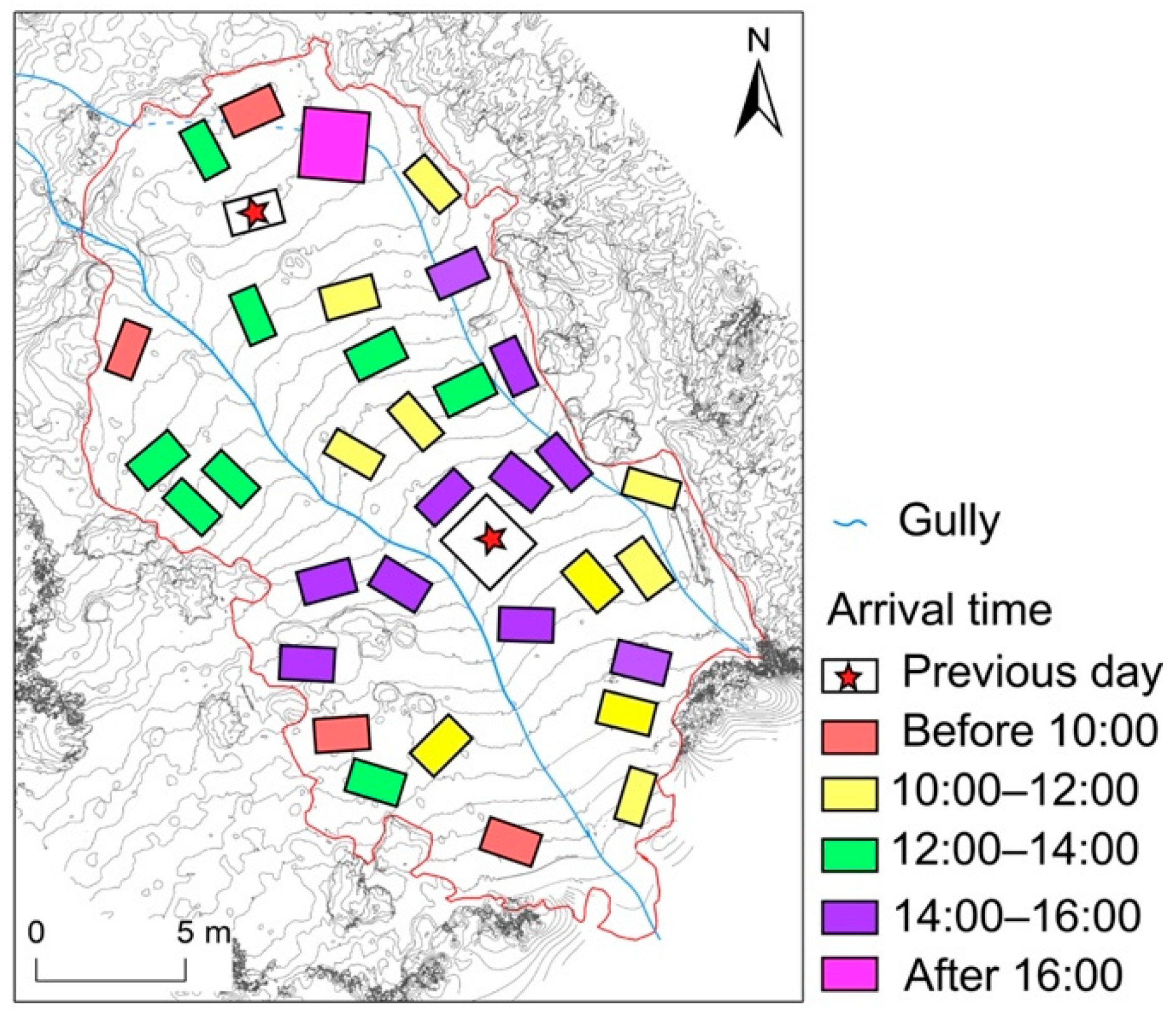
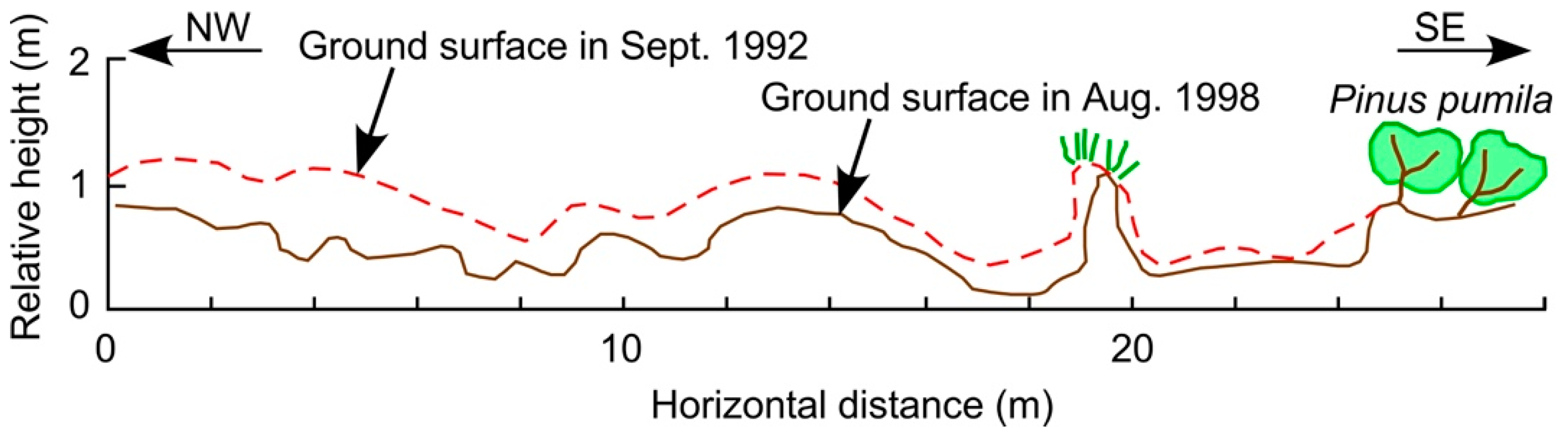
3.2. Topographic Characteristics of the Campsite

This study generated a detailed topographic map with contour intervals of 10 cm using the photographs taken in 2017 by the pole-mounted camera (Figure 7). Two gullies, shown with blue lines, have developed on the campsite surface—the one located near the centre of the campsite is deeper than the other. Additionally, the topographic map shows that the campsite terrain slopes toward the northwest.
Figure 8 shows the profiles of the ground surface along lines 1 and 2 shown in Figure 7. The ground surface of the current campsite is not flat and the location of the gullies can be identified clearly from the profile (Figure 8a). Compared to the surrounding places with vegetation, the ground surface of the campsite is lower by 30–60 cm. If the surface of the “vegetation islands” is assumed as the original ground surface, about 30–60 cm of soil has eroded since the initial use of the campsite (Figure 8a,b).

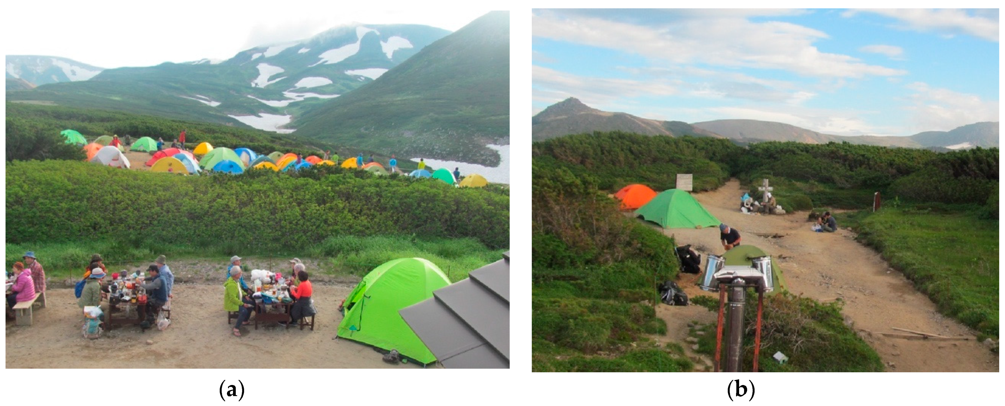
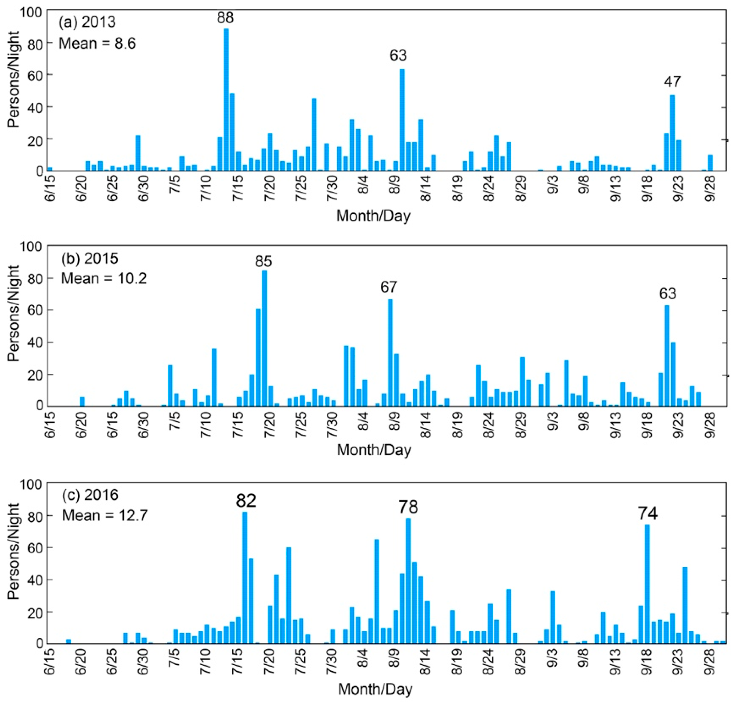
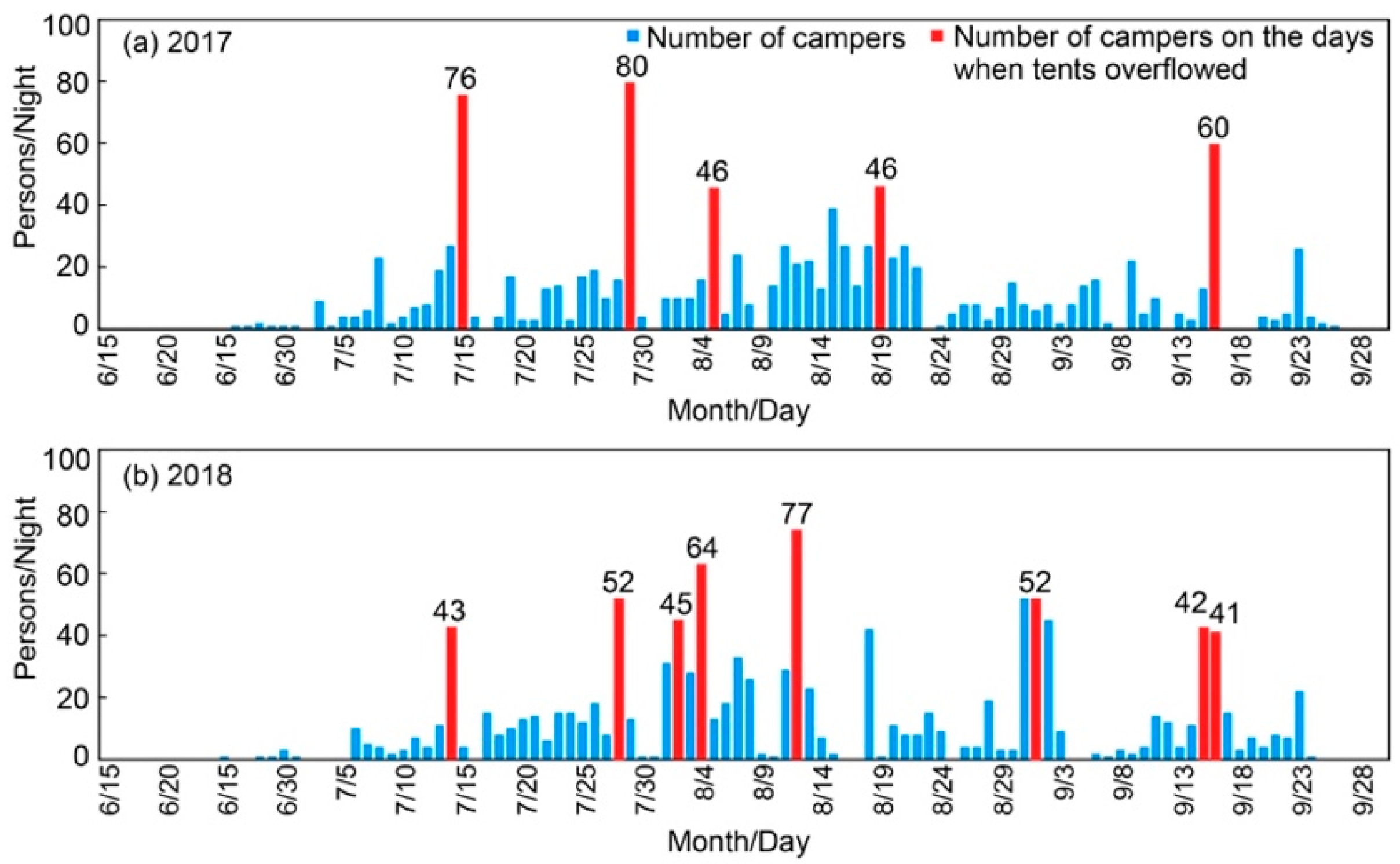
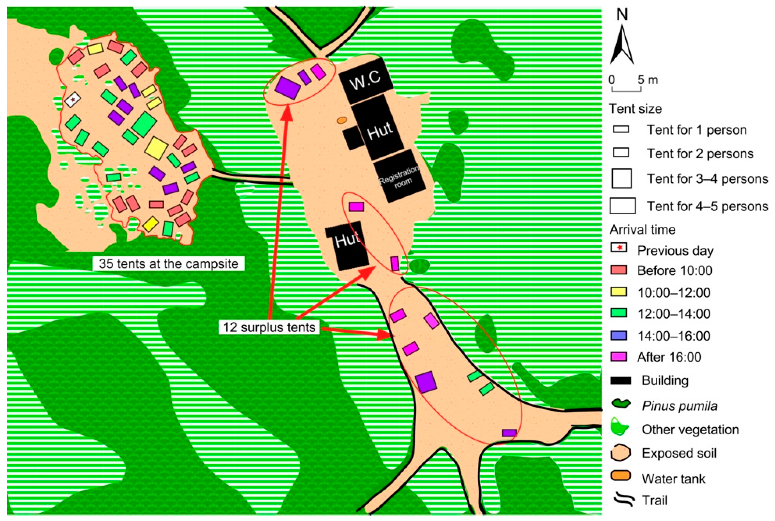
3.3. Analyses of the Number of Campers and Campsite Situation

Figure 9 shows that the average annual use level (blue bars) was about 1800 persons until 1992 when the old Kuro-dake Campsite was closed. Although the size of the campsite decreased from 1338 m2 to 394 m2 (measured by the aerial photographs of 2017), the use level was high in the first two years after the site relocation (1993 and 1994). There are no data available on the use level from 1995 to 2007; however, the annual number of hikers/climbers on Japanese mountains (green bars) indicate a similar level until 2002, implying that the annual use level of the current campsite has not dramatically changed. The annual number of hikers/climbers in Japan decreased from 2003 to 2008 and is believed to be the result of the frequent natural hazards, such as the widespread earthquakes in 2003 and 2007 and floods with extreme rainfall in 2004 and 2006 [34]. The decreased annual use level in 2008 with 336 persons (blue bars) corresponds to this trend (green bars). The annual use level of the current campsite is available again after 2008 (except for 2010) and shows an increasing trend. This increase is likely because most users of the current campsite are beginners, who prefer easy-access sites and advanced technology that enables them to carry light-weight mountain gear, such as tents, sleeping bags and cooking stoves.
The daily-use level data in recent years show relatively higher use around the weekends and holidays between July and September (Figure 10). The high daily-use level each year is about seven times the mean daily-use level of the year. On those busy days, some campers pitched their tents on the nearby trails: five times in 2017 and eight times in 2018 (Figure 11a,b; Table 1). Figure 12 exemplifies the overcrowding on 15 July 2017. On that day, 35 tents were pitched at the campsite and 12 tents were pitched on the nearby trails. The early arrivals tended to choose flat places and keep relatively more distance from the adjacent tents; this was observed during the field work in 2018 as well (Figure 13). Among the late arrivals in the afternoon, some campers used the remaining places between the gullies and the others had to pitch their tents on the gully in the north-eastern part of the campsite. However, all campers avoided the deep gully in the centre of the campsite.

3.4. Questionnaire Survey

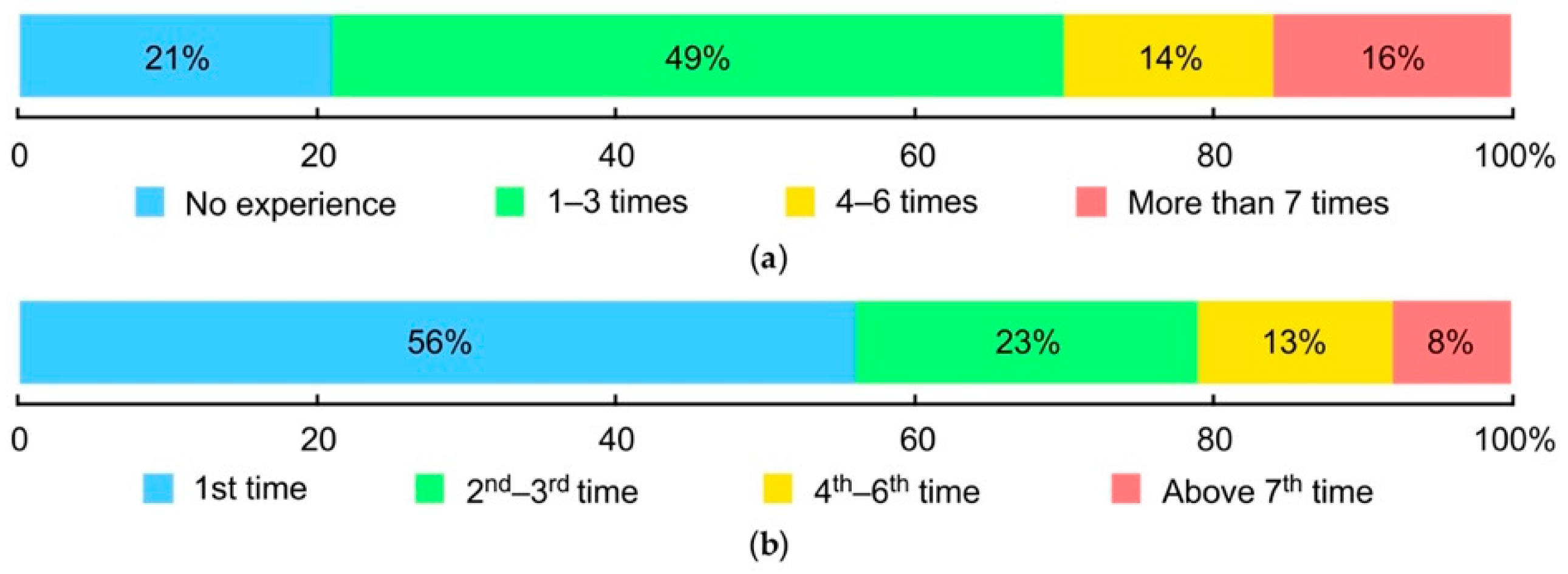
3.4.1. Characteristics of Campers at the Kuro-Dake Campsite

Most respondents prefer the campsite to the hut for overnight stay (Figure 14). Table 2 shows that the length of stay is short, with a mean length of 1.25 (std. = 1.57) days. The respondent who answered 28 nights is an exception; he is a member of a research team studying brown bears in the park. Seventy-eight percent of the respondents stay only at the Kuro-dake Campsite during their trips in DNP (Figure 15a) and do not go for long-distance hiking/trekking. More than half of the respondents thought that they could not accomplish their trips without staying at the Kuro-dake Campsite or are not sure about being able to accomplish their trips without staying at the site (Figure 15b).
Figure 16 shows that 70% of the respondents have at most three previous experiences of staying at campsites/campgrounds in other places and 56% have never stayed at the Kuro-dake Campsite before. This signifies that many of the respondents are new to camping.

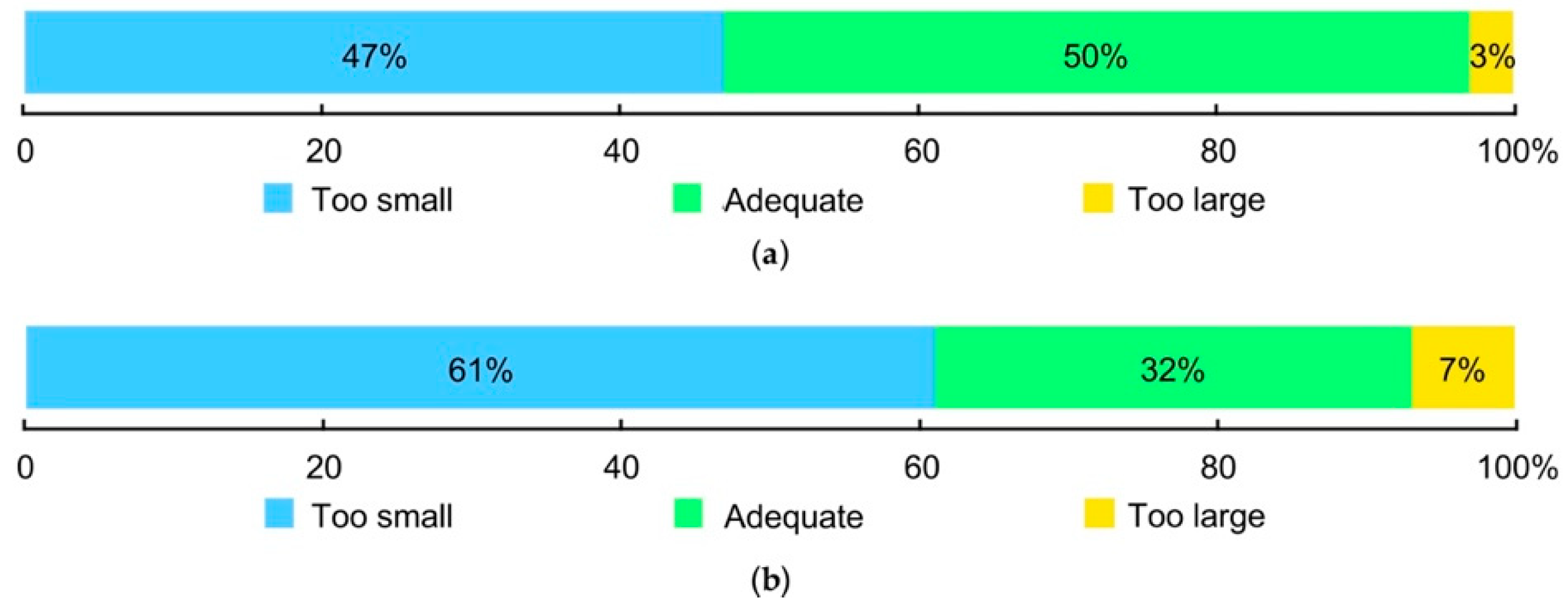
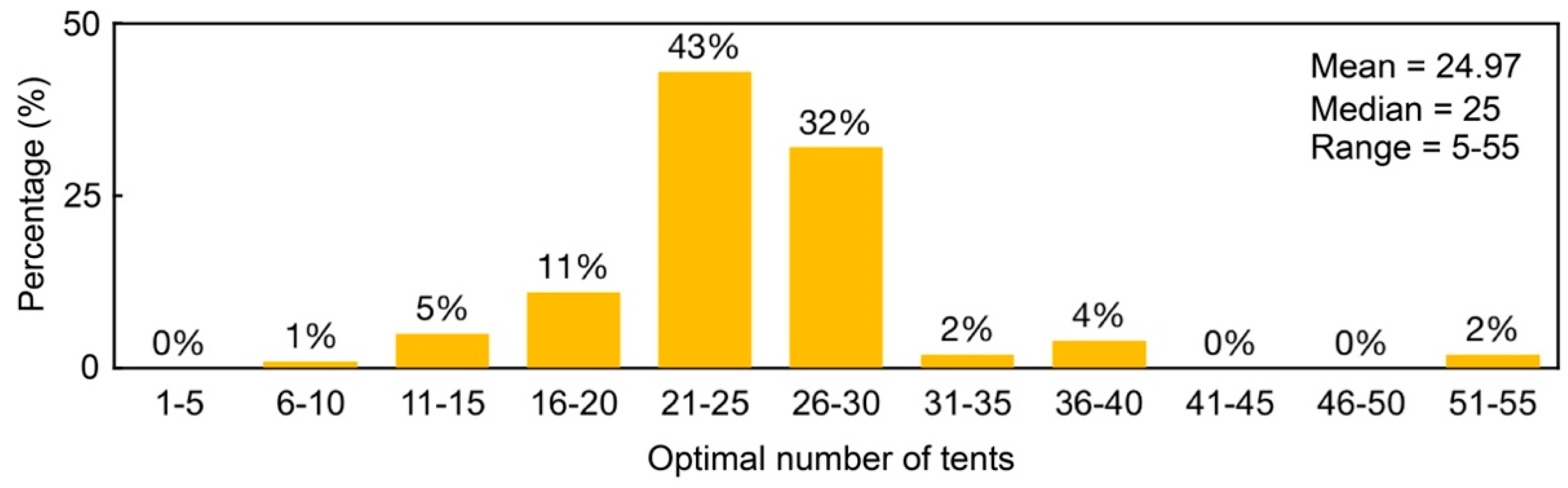
3.4.2. Opinions on the Size and Conditions of the Current Campsite

Figure 17a shows that 47% of the respondents perceive the size (area) of the current site as “too small” and around half of the respondents perceive it to be “adequate.” However, among the respondents from the surplus tents, the proportion of “too small” is almost twice that of “adequate” (Figure 17b). Figure 18 shows that respondents’ answers to the optimal number of tents, that is, the maximum number of tents that can comfortably be pitched at the campsite, ranges from 5 to 55. Three-fourths of the campers think that the optimal number of tents is between 21 and 30 and 92% of the respondents did not want more than 30 tents (Figure 18).
The association between respondents’ opinions on the current site conditions and the overcrowding was analysed with Pearson’s Chi-Square test (Table 3) and a significant association is observed (χ2 = 22.55, p = 0.000). The proportion of respondents on busy days to ordinary days was almost the same (51%:49%). The proportion of “somewhat dissatisfied” and “strongly dissatisfied” respondents on busy days is higher. Among the specific factors that lead to a dissatisfactory experience, the excessive sloping of the ground surface is the first, followed by excessive proximity to the other tents and undulating ground surface (Figure 19).

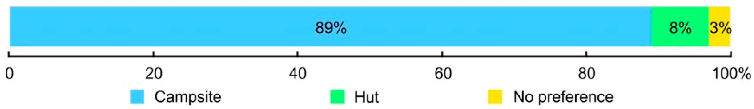
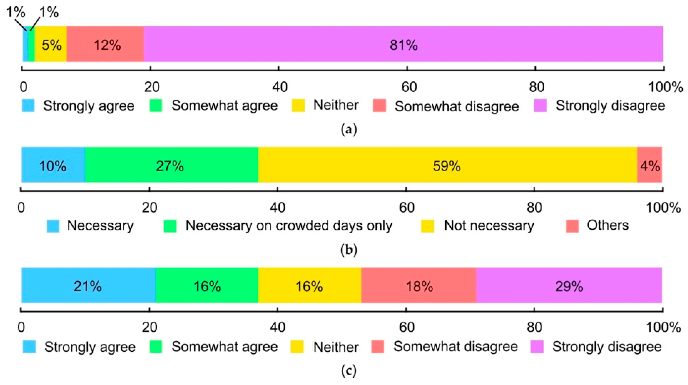
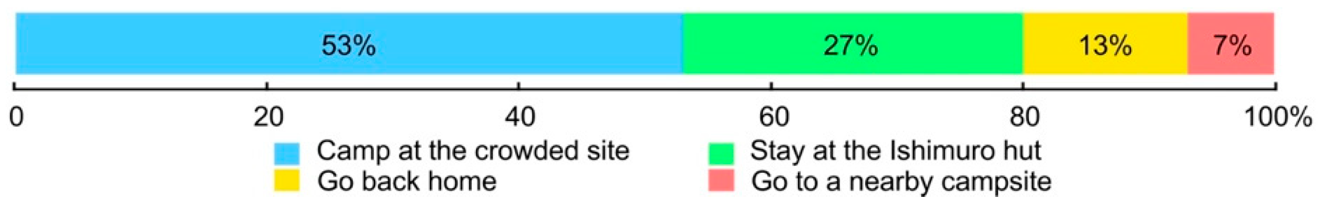
3.4.3. Attitudes to Potential Management Actions

Most respondents disagree with the idea of closing the current site (Figure 20a). Only 10% of the respondents think that use limit is necessary for future campsite management and 27% of the respondents think it is only necessary on crowded days (Figure 20b). Almost half of the respondents disagree with the proposed reservation system for future site management (Figure 20c). Among the campers surveyed in 2018 (n = 210), 71% mentioned that they are not aware of the existence of a reservation system elsewhere in the world. This could be due to the high proportion of beginners who use this campsite (Figure 16). These campers (n = 210) were then given an explanation about the reservation system. There was a change in their attitude toward the proposed reservation system following the explanation (Table 4). The proportion of in-favour (sum of “strongly agree” and “somewhat agree”) significantly increases (T = 12.340, p = 0.000). Campers who pitched their tents on the nearby trails (n = 15) were asked to answer another question: “What would you do if pitching tents outside the designated site was strictly prohibited in the future?” More than half of them stated that they would stay at the Ishimuro hut (Figure 21).

4. Discussion

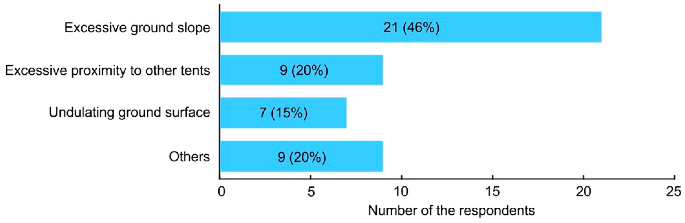
4.1. Problems at the Current Campsite

Owing to a lack of formal management, it is not possible to control the impacts of camping within the designated area. During the two-year study period at the Kuro-dake Campsite, surplus tents were observed 13 times (Figure 11). The use level on those busy days was 41 persons/night or more. If the increase in the number of campers (Figure 9) is uncontrolled, the daily-use level on busy days would become even worse. Previous studies [35,36,37] have also pointed out that visitors create new tent sites when camping is unregulated. The sudden decrease in the area because of the relocation of the campsite (from 1338 m2 in the old site to 394 m2 in the current site) resulted in a serious problem of overuse. The relocation from the old site to the current site with no management created the problem of areal shortage at the site.
To cope with the overcrowding, the then manager of the Ishimuro hut expanded the campsite, which is indicated in the interview survey. The measurements of the current campsite area using the aerial photographs of 2012 and 2017 show that a bare ground expansion (48 m2 of area) has occurred at the current campsite. The small area of the current site (394 m2 in 2017 compared to 1338 m2 of the old site) cannot support the heavy use on busy days (Figure 10 and Figure 11, Table 1). The use of signage indicating the boundary of designated sites has had considerable effect in preventing campers from further expanding an established campsite [1,16]. However, at the Kuro-dake Campsite, the boundary of the site is shown with a rope. The location of the rope has changed, so it can be inferred that there has been an expansion in the area. This expansion is due to the willingness of the then managers of the hut to allow campers beyond the designated area. Such ad hoc personal treatment should not be allowed, requiring measures to mitigate or avoid further increase in the bare ground and soil erosion.
The second problem is site slope, one of the critical determinants of erosion potential [2,38]. The current campsite slopes toward the northwest, which is identified on the produced topographic map (Figure 7). A previous study conducted on the old site reported that 7816 m3 of soil had eroded from 1966 to 1997 [26]. One of the reasons for such grave soil erosion is that the soil at the old site is mainly composed of unconsolidated volcanic materials vulnerable to erosion. Considering both the sloping surface and the surface materials, the current site will continue to face this problem in the near future as well, as shown by the presence of two gullies (Figure 7).
Field observation of tent-site selection by campers reveals that some of the late arrivals had to pitch their tents in the gully, while the early arrivals tended to choose the limited flat places and avoid the gullies (Figure 12 and Figure 13). Soil erosion at the old Kuro-dake Campsite continued for six years after its closure, as Figure 22 shows [26]. A gully erosion tends to continue and intensify in the absence of an intervention [2]. Without active management, gullies on the current Kuro-dake Campsite will become wider and deeper. Then the current site will also become unusable, similar to the old site. Further, if the number of campers continues to increase (Figure 9), more tents would overflow on the nearby trails in the future.
The third problem is the deterioration of the visitor experience. The results from the questionnaire survey show that 47% of the respondents find the current campsite too small (Figure 17). Some campers were not able to find satisfactory spots for pitching their tents on busy days (Figure 3). The overcrowding on busy days has already influenced the quality of campers’ experience (Table 3). On busy days, the number of tents at the campsite often exceeds 30, which is more than the optimal number for 92% of the respondents (Figure 18), indicating that the use on busy days should be regulated.

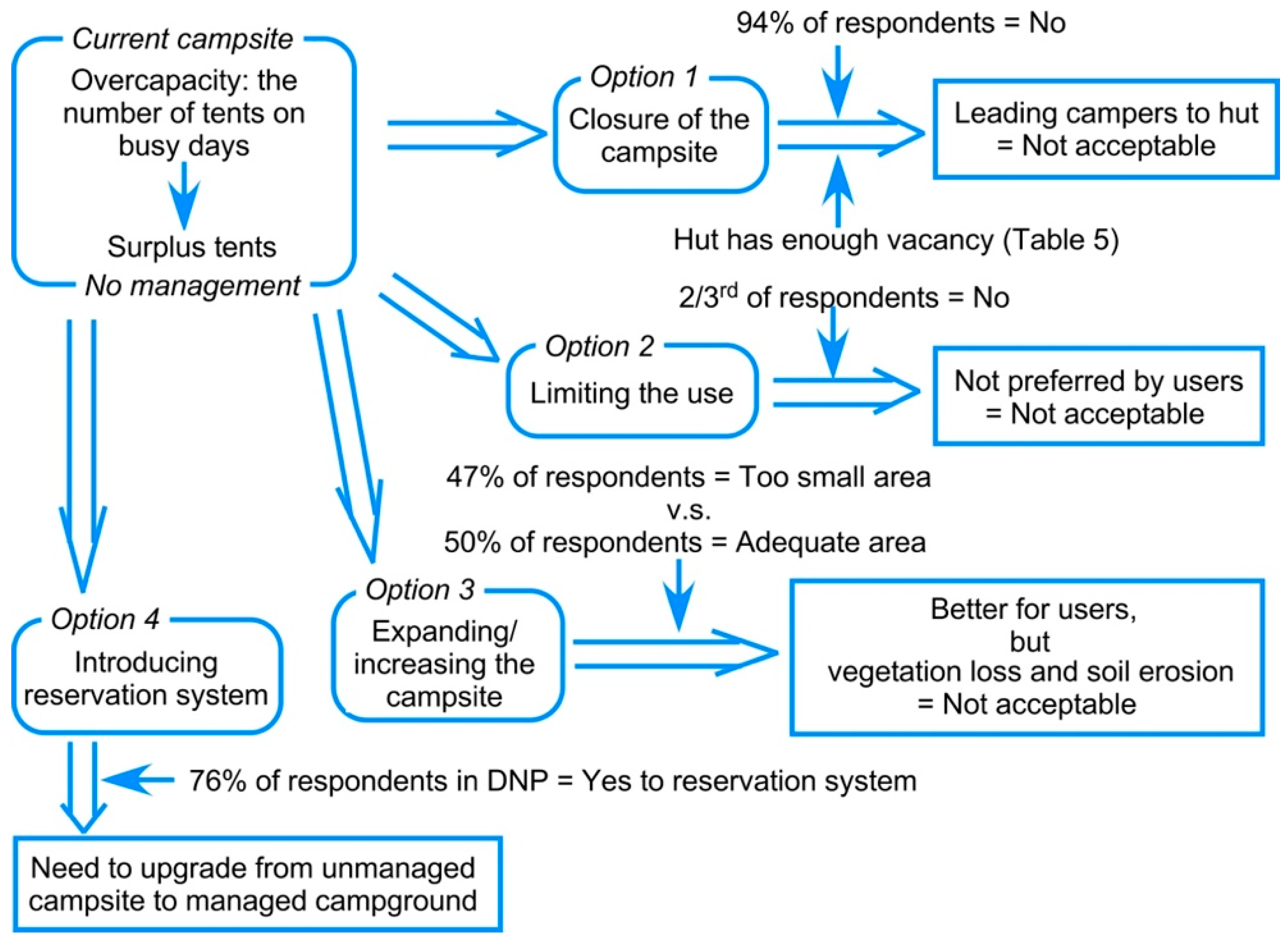
4.2. Possibility of Management Options

The foregoing discussion clearly demonstrates the need for management at the Kuro-dake Campsite. Field observations, interview surveys and previous studies [25,26] reveal four options to deal with the erosion and overcrowding at the Kuro-dake Campsite (Figure 23). Closure of the campsite (Option 1) would be the most effective measure to stop further human impact [39,40]. The shelters in Isle Royale National Park have a good effect in shielding resources when compared to campgrounds [1,16]. The collected data of the number of overnight users at the Ishimuro hut suggest that making better use of the available space in the hut would help to reduce the pressure on the campsite. There are vacancies in the hut even when the campsite is full (Table 5). However, 94% of the respondents disagree with the site closure (Figure 20a). Although there are always enough vacancies in the hut, 89% of the respondents do not want to stay in the hut and prefer the freedom of the campsite (Figure 14). Therefore, this option would not be accepted by most campers.
Option 2 is to limit the use within the capacity of the current campsite. Use limitation is one of the most common management measures implemented to deal with overcrowding in popular places. Generally, a maximum capacity (of users allowed) is determined by managers based on the physical and ecological state of the campground [2]. This measure has a good effect in reducing the number of impacted sites. At the Kuro-dake Campsite, this option can avoid further site expansion. When limited quotas are distributed on a first-come, first-serve basis, users with limited time to visit or who live far away from the campsite/campground might feel unfairly treated. Therefore, limited quotas are not preferred by such users [2]. Cole and Hall [41] also pointed out that users are less supportive of use limitation as a way to protect solitude or other aspects of visitor experience. On the Kuro-dake Campsite, two-thirds of the respondents opposed limiting the use (Figure 20b). This option, therefore, would not be accepted either.
Option 3 is to expand the campsite enough to accommodate all campers within the designated campsite or increase the number of campsites. Constructing additional campgrounds in areas with permanent shortage is one of the options to deal with overcrowding caused by increasing use [42]. The current size is considered “too small” by 47% of the respondents and “adequate” by 50% of the respondents (Figure 17a). This option would be accepted by many users. However, expanding/increasing the campsite will create more vegetation loss and further soil erosion, which are not acceptable in terms of the wider goals of national parks.
Given that the options above are either not accepted by users or in terms of the wider goals of national parks, introducing a reservation system (Option 4) is recommended as the best possible option. A reservation system has been successfully adopted in other national parks and protected areas, including in the United States of America [5,16,19]. Camping at reserved, designated sites is believed to be effective in controlling the number of campgrounds and limiting impact [4,43,44]. This option is accompanied by use limitation. However, a reservation system enables campers to guarantee a tent site allocation in advance; otherwise, they can change their trip plan when no site is available. This is different from campgrounds where quotas are distributed on first-come, first-serve basis. The change in respondents’ attitude toward introducing a reservation system after an explanation (Table 4) suggests a reservation system might be successful in the study area for future campsite management: 76% of the respondents were in favour of introducing the reservation system for future campsite management.

4.3. Limitation of the Study and Future Research Directions

This study discussed four options to address the challenges associated with erosion and overcrowding. However, other possible options, which are not examined in this study, exist. One of them is to introduce tent pads and/or wooden camping platforms that are already used in the United States of America [4,16,30,42]. The spatial containment of camping activities by tent pads arranged singly or in clusters in sloping terrains effectively limit the area of disturbance associated with camping [4,16]. This management system can be introduced along with the reservation system proposed in this study. The system of tent pads/platforms in alpine settings has not been adopted by any campground in Japan’s national parks; studies on preferences of both campers and park managers to introduce such a management system should be conducted in the future.

5. Conclusions

This study examined the impacts of recreational activities on the current Kuro-dake Campsite. The area of the bare ground has increased in recent years, with growing use levels. Early arrivals at the campsite tend to avoid the eroded sites when pitching their tents. The daily-use level on busy days is nearly seven times the average use level in the year. The unmanaged Kuro-dake Campsite must be upgraded to a campground, so that formal management can be practiced in order to control the human impact on natural resources and to provide a high-quality recreational experience. Based on the conditions of the current site, the following management measures are suggested: (1) managing the ground surface of the site to mitigate/stop further soil erosion and (2) introducing a reservation system to deal with overcrowding. These proposed measures would also be applicable to other unmanaged campsites in the DNP.

Author Contributions

Conceptualization, T.W. (Ting Wang) and T.W. (Teiji Watanabe); methodology, T.W. (Ting Wang) and T.W. (Teiji Watanabe); formal analysis, T.W. (Ting Wang) and T.W. (Teiji Watanabe); investigation, T.W. (Ting Wang) and T.W. (Teiji Watanabe); writing—original draft preparation, T.W. (Ting Wang); writing—review and editing, T.W. (Ting Wang) and T.W. (Teiji Watanabe); visualization, T.W. (Ting Wang) and T.W. (Teiji Watanabe); supervision, T.W. (Teiji Watanabe); project administration, T.W. (Teiji Watanabe); funding acquisition, T.W. (Teiji Watanabe).

Funding

This research was funded by JSPS KAKENHI Grant-in-Aid for Challenging Exploratory Research Grant Number JP15K12451.

Acknowledgments

The authors thank the Kamikawa Local Forest Office and the Rinyu Corporation for providing the unpublished data for this study. The authors are grateful to the managers of Ishimuro hut for their assistance with data collection. They also thank Yusuke Kobayashi of Hokkaido University for assisting in the long-pole photogrammetry and the use of a GNSS receiver.

Conflicts of Interest

The authors declare no conflict of interest.

References

  1. Leung, Y.F.; Marion, J.L. Recreation impacts and management in wilderness: A state-of-knowledge review. In Proceedings of the Wilderness Science in a Time of Change Conference, Missoula, MT, USA, 23–27 May 1999; Cole, M., Ed.; Rocky Mountain Research Station: Ogden, UT, USA, 2000. [Google Scholar]
  2. Hammit, W.E.; Cole, D.N.; Monz, C.A. Wildland Recreation: Ecology and Management, 3rd ed.; John Wiley & Sons Ltd.: New York, NY, USA, 2015; ISBN 978-1-118-39700-8. [Google Scholar]
  3. McEwen, D.; Cole, D.N. Campsite impact in wilderness areas. Parks Recreat. 1997, 32, 24–32. Available online: https://www.questia.com/magazine/1G1-19203757/campsite-impact-in-wilderness-areas (accessed on 25 February 2019).
  4. Leung, Y.F.; Marion, J.L. Characterizing backcountry camping impacts in Great Smoky Mountains National Park, USA. J. Environ. Manag. 1999, 57, 193–203. [Google Scholar] [CrossRef]
  5. Cole, D.N.; Foti, P.; Brown, M. Twenty years of change on campsites in the backcountry of Grand Canyon National Park. Environ. Manag. 2008, 41, 959–970. [Google Scholar] [CrossRef] [PubMed]
  6. Cole, D.N.; Monz, C.A. Spatial patterns of recreation impact on experimental campsites. J. Environ. Manag. 2004, 70, 73–84. [Google Scholar] [CrossRef]
  7. Cole, D.N.; Hall, T.E. Trends in Campsite Condition: Eagle Cap Wilderness, Bob Marshall Wilderness, and Grand Canyon National Park; Intermountain Research Station: Ogden, UT, USA, 1992; Available online: http://winapps.umt.edu/winapps/media2/leopold/pubs/222.pdf (accessed on 24 February 2019).
  8. Cole, D.N. Wilderness Campsite Impacts: Effect of Amount of Use; Intermountain Forest and Range Experiment Station: Ogden, UT, USA, 1982; Available online: https://www.fs.fed.us/rm/pubs_int/int_rp284.pdf (accessed on 14 February 2019).
  9. Cole, D.N.; Marion, J.L. Recreation impacts in some riparian forests of the Eastern United States. Environ. Manag. 1988, 12, 99–107. [Google Scholar] [CrossRef]
  10. Cole, D.N.; Bayfield, N.G. Recreational trampling of vegetation: Standard experimental procedures. Biol. Conserv. 1993, 63, 209–215. [Google Scholar] [CrossRef]
  11. Cole, D.N.; Fichtler, R.K. Campsite impact on three western Wilderness areas. Environ. Manag. 1983, 7, 275–288. [Google Scholar] [CrossRef]
  12. Smith, A.J.; Newsome, D. An integrated approach to assessing, managing and monitoring campsite im pacts in Warren National Park, western Australia. J. Sustain. Tour. 2002, 10, 343–359. [Google Scholar] [CrossRef]
  13. Pickering, C.; Rossi, S.D.; Hernando, A.; Barros, A. Current knowledge and future research directions for the monitoring and management of visitors in recreational and protected areas. J. Outdoor Recreat. Tour. 2018, 21, 10–18. [Google Scholar] [CrossRef]
  14. Cole, D.N. Managing ecological impacts at wilderness campsites: An evaluation of techniques. J. For. 1981, 79, 86–89. [Google Scholar] [CrossRef]
  15. Marion, J.L. Capabilities and management utility of recreation impact monitoring programs. Environ. Manag. 1995, 19, 763–777. [Google Scholar] [CrossRef]
  16. Marion, J.L.; Farrell, T.A. Management practices that concentrate visitor activities: Camping impact management at Isle Royale National Park, USA. J. Environ. Manag. 2002, 66, 201–212. [Google Scholar] [CrossRef]
  17. Reid, S.E.; Marion, J.L. Effectiveness of a confinement strategy for reducing campsite impacts in Shenandoah National Park. Environ. Conserv. 2004, 31, 274–282. [Google Scholar] [CrossRef] [Green Version]
  18. Bratton, S.P.; Hickler, M.G.; Graves, J.H. Visitor impact on backcountry campsites in the Great Smoky Mountains. Environ. Manag. 1978, 2, 431–441. [Google Scholar] [CrossRef]
  19. Eagleston, H.; Marion, J.L. Sustainable campsite management in protected areas: A study of long-term ecological changes on campsites in the Boundary Waters Canoe Area Wilderness, Minnesota, USA. J. Nat. Conserv. 2017, 37, 73–82. [Google Scholar] [CrossRef]
  20. Cole, D.N.; Ranz, B. Temporary campsite closures in the Selway-Bitteroot Wilderness. J. For. 1983, 81, 729–732. [Google Scholar] [CrossRef]
  21. Cole, D.N. Long-term effectiveness of restoration treatments on closed wilderness campsites. Environ. Manag. 2013, 51, 642–650. [Google Scholar] [CrossRef] [PubMed]
  22. Marion, J.L. Developing a Natural Resource Inventory and Monitoring Program for Visitor Impacts on Recreation Sites: A Procedural Manual; National Park Service: Denver, CO, USA, 1991.
  23. Dauwalter, D.C.; Rahel, F.J. Patch size and shape influence the accuracy of mapping small habitat patches with a global positioning system. Environ. Monit. Assess. 2011, 179, 123–135. [Google Scholar] [CrossRef] [PubMed]
  24. Barros, A.; Pickering, M.C. How networks of informal trails cause landscape level damage to vegetation. Environ. Manag. 2017, 60, 57–68. [Google Scholar] [CrossRef]
  25. Sakamoto, J. Daisetsuzan Kokuritsukoen Kuro-dake Kyanpujo ni okeru Riyo to Kankyo no Henka (Changes in the Use and Environments in the Kuro-dake Campsite, Daisetsuzan National Park). Bachelor’s Thesis, Hokkaido University, Sapporo, Japan, 1991. (In Japanese). [Google Scholar]
  26. Watanabe, T. Daisetsuzan kokuritsukoen: Yaeishiteichi no hozen to kanri (Daisetsuzan National Park: Conservation and management of the campsites). Chiri (Geography) 1998, 43, 77–83. (In Japanese) [Google Scholar]
  27. Gonçalves, J.A.; Moutinho, O.F.; Rodrigues, A.C. Pole photogrammetry with an action camera for fast and accurate surface mapping. Int. Arch. Photogramm. Remote Sens. Spat. Inf. Sci.—ISPRS Arch. 2016, 41, 571–575. [Google Scholar] [CrossRef]
  28. Rossi, R.K. Evaluation of Structure-from-Motion from a Pole Mounted Camera for Monitoring Geomorphic Change. Master’s Thesis, Utah State University, Logan, UT, USA, 2018. Available online: https://digital commons. usu.edu/etd/6924 (accessed on 26 February 2019).
  29. Wessling, R.; Maurer, J.; Krenn-leeb, A. Structure from motion for systematic single surface documentation of archaeological excavations. In Proceedings of the 18th International Conference on Cultural Heritage and New Technologies, Vienna, Austria, 11–13 November 2013; Museen der Stadt Wien—Stadtarchäologie: Vienna, Austria, 2014; pp. 1–12. Available online: http://www.chnt.at/proceeding-chnt-18/ (accessed on 26 February 2019).
  30. Daniels, M.L.; Marion, J.L. Visitor evaluations of management actions at a highly impacted Appalachian Trail camping area. Environ. Manag. 2006, 38, 1006–1019. [Google Scholar] [CrossRef]
  31. Farrell, T.; Hall, T.E.; White, D.D. Wilderness campers’ perception and evaluation of campsite impacts. J. Leis. Res. 2001, 33, 229–250. [Google Scholar] [CrossRef]
  32. MoE. Shizenkoento Shisetsu Gijutsu Shishin (Guideline for Technical Standards of Natural Park Facilities); Ministry of the Environment: Tokyo, Japan, 2014. (In Japanese)
  33. MoE. Daisetsuzan Kokuritsukoen Kanri Keikaku Sho (Park Plan of Daisetsuzan National Park); Ministry of the Environment: Tokyo, Japan, 2007. (In Japanese)
  34. Yamagata, T. Heisei Tozan Buum ni kansuru Ichikousatsu (Climbing Trend in Heisei Period). Bull. Shohoku Coll. 2013, 189–204, (In Japanese with English abstract). [Google Scholar]
  35. Cole, D.N. Campsites in Three Western Wildernesse: Proliferation and Changes in Condition Over 12 to 16 Years; Intermountain Research Station: Ogden, UT, USA, 1993. [Google Scholar]
  36. McEwen, D.; Cole, D.N.; Simon, M. Campsite Impacts in Four Wildernesses in the South-Central United States; Intermountain Research Station: Ogden, UT, USA, 1996. [Google Scholar]
  37. Cole, D.N. Changing Conditions on Wilderness Campsites: Seven Case Studies of Trends Over 13 to 32 Years; Rocky Mountain Research Station: Ogden, UT, USA, 2013. [Google Scholar]
  38. Schaetzl, R.J.; Thompson, M.L. Soils: Genesis and Geomorphology, 3rd ed.; Cambridge University Press: New York, NY, USA, 2015; ISBN 978-1-107-01693-4. [Google Scholar]
  39. Stohlgren, T.J.; Parson, D.J. Vegetation and soil recovery in wilderness campsites closed to visitor use. Environ. Manag. 1986, 10, 375–380. [Google Scholar] [CrossRef]
  40. Marion, J.; Cole, D.N. Spatial and temporal variation in soil and vegetation impacts on campsites. Ecol. Appl. 1996, 6, 520–530. [Google Scholar] [CrossRef]
  41. Cole, D.N.; Hall, T.E. Wilderness Visitors, Experiences, and Management Preferences: How They Vary with Use Level and Length of Stay; Rocky Mountain Research Station: Ogden, UT, USA, 2008. [Google Scholar]
  42. Farrell, T.A.; Marion, J.L. Camping impact management at Isle Royale National Park: An evaluation of visitor activity containment policies from the perspective of social conditions. In Proceedings of the Wilderness Science in a Time of Change Conference, Missoula, MT, USA, 23–27 May 1999; Cole, M., Ed.; Rocky Mountain Research Station: Ogden, UT, USA, 2000. [Google Scholar]
  43. Marion, J.L. A review and synthesis of recreation ecology research supporting carrying capacity and visitor use management decisionmaking. J. For. 2016, 114, 339–351. [Google Scholar] [CrossRef]
  44. Marion, J.; Arredondo, J.; Wimpey, J.; Meadema, F. Applying recreation ecology science to sustainably manage camping impacts: A classification of camping management strategies. Int. J. Wilderness. 2018, 24, 84–101. Available online: https://www.researchgate.net/publication/328462286_Applying_Recreation_Ecology_Science_to_Sustainably_Manage_Camping_Impacts_A_Classification_of_Camping_Management_Strategies (accessed on 25 February 2019).
Figure 1. Locations of the main recreational facilities in Daisetsuzan National Park.
Environments 06 00034 g001
Figure 2. Location of the current Kuro-dake Campsite (Base: georeferenced aerial photograph from 2017).
Environments 06 00034 g002
Figure 3. The overcrowding at the current Kuro-dake Campsite. (a) The current campsite full of tents; (b) Tents pitched on the nearby trail (Photos: T. Wang, 28 July 2018).
Environments 06 00034 g003
Figure 4. (a) A 4-m long pole with a camera held by an operator; (b) Camera mounted at the end of the pole (Photos: T. Wang, 6 September 2017).
Environments 06 00034 g004
Figure 5. Attributes of the respondents (n = 346). (a) Age (years); (b) Gender; and (c) Nationality.
Environments 06 00034 g005
Figure 6. Georeferenced aerial photographs showing the boundaries of the current campsite (a) 15 August 2012; (b) 6 September 2017; and (c) Changes in the area of the current campsite.
Environments 06 00034 g006
Figure 7. Topographic map of the current campsite created with the photographs taken by the pole-mounted camera on 6 September 2017 (contour interval = 10 cm).
Environments 06 00034 g007
Figure 8. Profiles of the current campsite in 2017. See Figure 7 for locations.
Environments 06 00034 g008
Figure 9. The annual use level of the current campsite (Compiled from unpublished data provided by Mr. Takemura and Mr. Sato, former managers of the Ishimuro hut and the ropeway company); and annual number of hikers/climbers in Japan (Compiled from the data in Leisure White Paper 1994, 2007, 2010).
Environments 06 00034 g009
Figure 10. Daily-use level of the current campsite in the recent years (Compiled from unpublished data provided by Rinyu Corporation). (a) 2013; (b) 2015; and (c) 2016.
Environments 06 00034 g010
Figure 11. Daily-use level of the current campsite in (a) 2017 and (b) 2018 (Compiled from unpublished data provided by Rinyu Corporation).
Environments 06 00034 g011
Figure 12. An example of the overcrowding on 15 July 2017 (Base map: created by referencing the orthophoto of 2017). Each tent is shown in a different colour according to its arrival time.
Environments 06 00034 g012
Figure 13. An example of the campsite situation on 28 July 2018, showing that campers tend to avoid the gullies. The section with the broken line of the gully is not deep. Contour intervals: 10 cm.
Environments 06 00034 g013
Figure 14. Preference for type of stay (n = 346).
Environments 06 00034 g014
Figure 15. The proportion of (a) campsite use; and (b) campers who think they can accomplish their trips without staying at the Kuro-dake Campsite (n = 346).
Environments 06 00034 g015
Figure 16. The proportion of respondents’ experiences in staying (a) at campsites/campgrounds in other places; and (b) at the Kuro-dake Campsite (n = 346).
Environments 06 00034 g016
Figure 17. The proportion of respondents’ opinions on the size of the current campsite. (a) answers of all respondents (n = 346); and (b) answers of the respondents from surplus tents on the trail (n = 28).
Environments 06 00034 g017
Figure 18. Optimal number of tents that can be comfortably pitched at the current campsite (n = 346).
Environments 06 00034 g018
Figure 19. Frequency distribution of dissatisfaction factors of the current campsite (n = 46).
Environments 06 00034 g019
Figure 20. The proportion of respondents’ opinions on (a) site closure; (b) limiting use; and (c) proposed reservation system for campsite management (n = 346).
Environments 06 00034 g020
Figure 21. Surplus campers’ choices of alternative stay when pitching a tent on the nearby trail is strictly prohibited (n = 15).
Environments 06 00034 g021
Figure 22. Ground surface of the old Kuro-dake Campsite in 1992 and 1998, six years after its closure (Reproduced from [26]).
Environments 06 00034 g022
Figure 23. Improvement options for future sustainability of the Kuro-dake Campsite.
Environments 06 00034 g023
Table 1. The number of surplus tents in the campsite in 2018.
DateNumber of Tents at the CampsiteNumber of Surplus TentsTotal
14 July27330
28 July35540
2 August28230
4 August37239
12 AugustAt least 34At least 1At least 35
1 September31132
15 September28230
16 September28432
Mean31333
Min27130
Max37540
Table 2. Length of stay.
Length of StayFrequency (n = 346)Proportion (%)
1 night30187.0
2 nights4011.6
3 nights20.6
8 nights20.6
28 nights10.3
Total346100.0
Table 3. Association between respondents’ opinions on the current site condition and overcrowding.
On Ordinary DaysOn Busy DaysTotal
Count% Within SatisfactionCount% Within SatisfactionCount% Within Satisfaction
Opinions on site conditionStrongly satisfied6053%5447%114100%
Somewhat satisfied8957%6643%155100%
Neither650%650%12100%
Somewhat dissatisfied1430%3370%47100%
Strongly dissatisfied211%1689%18100%
Total17149%17551%346100%
Pearson’s Chi-Square (χ2 = 22.55, p = 0.000).
Table 4. Comparison of the opinions on introducing a reservation system before and after the system was explained to all respondents in 2018 (n = 210). Mean value denotes the mean of Likert scale (1–5).
ContentsStrongly Agree (Value = 1)Somewhat Agree (Value = 2)Neither (Value = 3)Somewhat Disagree (Value = 4)Strongly Disagree (Value = 5)Mean Value
Before explanation (B)26%15%15%16%28%3.04
After explanation (A)61%15%11%9%4%1.81
Pair B-ANANANANANA1.23
Paired-T test (95% confidence interval, p = 0.000).
Table 5. The number of overnight users of the Kuro-dake Campsite and Ishimuro hut (capacity: 150) on busy days.
DateNumber of Campers (A)Number of Hut Users (B)Vacancy at Ishimuro Hut—Number of Hut Users (150—B)
15 July 2017767971
29 July 20178038112
5 August 20174633117
19 August 20174647103
16 September 2017605595
14 July 20184336114
28 July 20185248102
2 August 20184524126
4 August 20186435115
12 August 20187734116
1 September 20185243107
15 September 2018425397
16 September 20184148102

