Next Issue
Volume 6, March
Previous Issue
Volume 6, January


Environments, Volume 6, Issue 2 (February 2019) – 18 articles

Cover Story (view full-size image): 
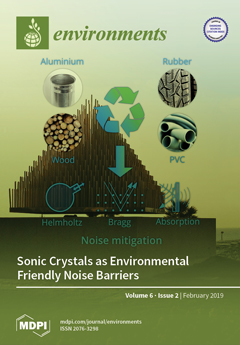
Despite their diffusion, common noise barriers present issues that sometimes hinder installation, such as sound reflection, diffraction at edges, and reduction of the field of view, natural light, and air flow. Thus, recently, sonic crystals are being studied, combined with Bragg diffraction with Helmholtz resonators and material absorption properties. Research is focused on using wood, PVC, aluminum, or scatterers covered by tire rubber, thus fully embracing the concept of green and circular economy. View Paper here.
  • Issues are regarded as officially published after their release is announced to the table of contents alert mailing list.
  • You may sign up for e-mail alerts to receive table of contents of newly released issues.
  • PDF is the official format for papers published in both, html and pdf forms. To view the papers in pdf format, click on the "PDF Full-text" link, and use the free Adobe Reader to open them.
Order results
Result details
Select all
Export citation of selected articles as:
14 pages, 892 KiB  
Article
Concentration of Organotin and Booster Biocides in Sediments of Seagrass Area from Sungai Pulai Estuary, South of Johor, Malaysia
by Aqilah Mukhtar, Ferdaus Mohamat-Yusuff, Syaizwan Zahmir Zulkifli, Hiroya Harino, Ahmad Ismail and Koji Inoue
Environments 2019, 6(2), 26; https://doi.org/10.3390/environments6020026 - 25 Feb 2019
Cited by 18 | Viewed by 5178
Abstract
Antifouling compounds are widely used in paints applied on ship hulls to prevent attachment of fouling organisms. However, a certain amount of these chemicals could leach from the painted surface, enter seawater, and pose deleterious effects on various marine biotas. The present study [...] Read more.
Antifouling compounds are widely used in paints applied on ship hulls to prevent attachment of fouling organisms. However, a certain amount of these chemicals could leach from the painted surface, enter seawater, and pose deleterious effects on various marine biotas. The present study aimed to determine the concentration of organotin (OT) compounds and booster biocides in sediments collected from the seagrass area of Sungai Pulai estuary, Malaysia. The sediment samples were collected from three points on the seagrass bed, brought back to the laboratory, extracted using standard extraction procedure, and the analytes were analysed using gas chromatography-mass spectrometry (GC-MS) method. The results showed that tributyltin (TBT) concentrations in sediments were within the range of 8.1 ± 0.4 to 10.6 ± 0.5 µg/kg, whereas the values of triphenyltin (TPT) were between 17.1 ± 0.9 and 19.4 ± 1.0 µg/kg. The range of concentration of booster biocides, namely diuron, dichlofluanid chlorothalonil, Irgarol 1051, M1, and Sea-Nine 211, were from <0.1 to 22.9 ± 1.1, 48.7 ± 2.4 to 800 ± 40, <0.1 to 6.2 ± 0.3, <0.1 to 1.4 ± 0.1, 44 ± 2.2 to 877 ± 44, and 9.1 ± 0.5 to 170 ± 8.5 µg/kg, respectively. The concentration of organotin was much lower than the previous study conducted in southern Johor. Meanwhile, the increased concentration of booster biocides proves the use of these compounds as antifouling paints in shipping systems nowadays. Full article
(This article belongs to the Special Issue Analysis of Environmental Pollutants)
Show Figures

Figure 1

15 pages, 9374 KiB  
Article
Land-Use Change Detection with Convolutional Neural Network Methods
by Cong Cao, Suzana Dragićević and Songnian Li
Environments 2019, 6(2), 25; https://doi.org/10.3390/environments6020025 - 24 Feb 2019
Cited by 39 | Viewed by 9941
Abstract
Convolutional neural networks (CNN) have been used increasingly in several land-use classification tasks, but there is a need to further investigate its potential. This study aims to evaluate the performance of CNN methods for land classification and to identify land-use (LU) change. Eight [...] Read more.
Convolutional neural networks (CNN) have been used increasingly in several land-use classification tasks, but there is a need to further investigate its potential. This study aims to evaluate the performance of CNN methods for land classification and to identify land-use (LU) change. Eight transferred CNN-based models were fully evaluated on remote sensing data for LU scene classification using three pre-trained CNN models AlexNet, GoogLeNet, and VGGNet. The classification accuracy of all the models ranges from 95% to 98% with the best-performed method the transferred CNN model combined with support vector machine (SVM) as feature classifier (CNN-SVM). The transferred CNN-SVM model was then applied to orthophotos of the northeastern Cloverdale as part of the City of Surrey, Canada from 2004 to 2017 to perform LU classification and LU change analysis. Two sources of datasets were used to train the CNN–SVM model to solve a practical issue with the limited data. The obtained results indicated that residential areas were expanding by creating higher density, while green areas and low-density residential areas were decreasing over the years, which accurately indicates the trend of LU change in the community of Cloverdale study area. Full article
(This article belongs to the Special Issue Application of Remote Sensing and GIS in Environmental Studies)
Show Figures

Figure 1

17 pages, 4726 KiB  
Article
Noise Events Monitoring for Urban and Mobility Planning in Andorra la Vella and Escaldes-Engordany
by Rosa Ma Alsina-Pagès, Robert Garcia Almazán, Marc Vilella and Marc Pons
Environments 2019, 6(2), 24; https://doi.org/10.3390/environments6020024 - 22 Feb 2019
Cited by 7 | Viewed by 5409 | Correction
Abstract
Noise pollution is a critical factor and it has an important impact on public health, with the relationship between road traffic noise (RTN) and several illnesses in urban areas of particular concern. Andorra is currently developing a national strategy regarding noise pollution in [...] Read more.
Noise pollution is a critical factor and it has an important impact on public health, with the relationship between road traffic noise (RTN) and several illnesses in urban areas of particular concern. Andorra is currently developing a national strategy regarding noise pollution in their urban environments. The Ministry of Environment, Agriculture and Sustainability is trying to to identify, monitor, map and model the effects of noise pollution and design mitigation policies to reduce the impact in certain priority areas. This analysis should take into account the existence of different types of anomalous noise events (ANEs) present in the street, e.g., horns, people talking, music, and other events that coexist with RTN, to characterize the soundscape of each of the locations. This paper presents a preliminary analysis considering both the Signal-to-Noise Ratio (SNR) and the duration of the ANEs to evaluate their presence in urban areas in the three different locations in Andorra la Vella and Escaldes-Engordany. The experiments conducted required a 10-h recording campaign distributed in the three locations under study, which was evaluated on two different days, one during the week and the other on the weekend. Afterwards, the data were carefully labeled and the SNR of each event was evaluated to determine the potential impact of the four categories under study: vehicles, works, city life and people. Full article
(This article belongs to the Special Issue New Solutions Mitigating Environmental Noise Pollution)
Show Figures

Figure 1

11 pages, 1861 KiB  
Article
Water Quality Assessment of Surface and Groundwater Sources Using a Water Quality Index Method: A Case Study of a Peri-Urban Town in Southwest, Nigeria
by Samuel O. Olasoji, Nather O. Oyewole, Bayode Abiola and Joshua N. Edokpayi
Environments 2019, 6(2), 23; https://doi.org/10.3390/environments6020023 - 22 Feb 2019
Cited by 43 | Viewed by 14175
Abstract
Sustainable access to safe drinking water remains a global problem as more people in the world still consume water from unimproved sources. This study was carried out to evaluate the quality of 12 different water sources and 2 treated water used by a [...] Read more.
Sustainable access to safe drinking water remains a global problem as more people in the world still consume water from unimproved sources. This study was carried out to evaluate the quality of 12 different water sources and 2 treated water used by a peri-urban town in the Southwest region of Nigeria to assess their suitability for drinking and domestic use. Water quality parameters studied include pH, temperature, acidity, total alkalinity, chloride content and total CO2. A Flame Atomic Absorption spectrophotometer was used to determine the concentrations of Ca, Mg, Cu, Cr, and Pb in the water samples. The total coliform was determined using the most probable number technique while a qualitative method was used to detect the presence of faecal coliform and E. coli in the water samples. All the physicochemical water quality parameters complied with regulatory standards. Similarly, most of the heavy metals also complied except for some sites. Faecal coliform and E. coli tested positive for all the samples except one of the tap water sample. Majority of the water samples (86%) were rated as excellent based on the physicochemical parameters. One sample each was rated as having poor and good water quality, respectively. All the samples tested positive for faecal coliform bacteria and E. coli except one (treated water). It is recommended that Microbial water quality parameters be included in all Water Quality Index (WQI) analyses in order to give the true status of the quality of a water resource. Full article
Show Figures

Figure 1

16 pages, 258 KiB  
Review
Anthropocene Crisis: Climate Change, Pollinators, and Food Security
by Jennifer Marshman, Alison Blay-Palmer and Karen Landman
Environments 2019, 6(2), 22; https://doi.org/10.3390/environments6020022 - 21 Feb 2019
Cited by 52 | Viewed by 19124
Abstract
In this paper, we propose a new approach—understood as a whole-of-community approach—to address a dualistic and dysfunctional human/nature relationship. Of particular concern is the decline in health and numbers of the insects that pollinate an estimated 90 percent of the Earth’s flora and [...] Read more.
In this paper, we propose a new approach—understood as a whole-of-community approach—to address a dualistic and dysfunctional human/nature relationship. Of particular concern is the decline in health and numbers of the insects that pollinate an estimated 90 percent of the Earth’s flora and an estimated 35 percent of global crop volume. Specifically, bees provide the majority of biotic pollination and play a critical role in food crop pollination. Multiple factors are contributing to this growing problem including a changing climate. In 2016, the International Commission on Stratigraphy agreed that the concept of the Anthropocene—the human epoch—is of sufficient scale to be considered part of the geological time scale. This indicates that these crises are not random or passive—they are largely the direct result of human activities. Despite decades of awareness of these socio-ecological issues, they continue to worsen. In addition, the growing awareness of the critical role of pollinators is creating a new understanding of our interconnectedness with the “natural” world. We introduce the Bee City movement as a way to operationalize a whole-of-community approach. Individual action is critical, but addressing pollinator health in these forums legitimizes and provides an institutional space for otherwise fringe, or even marginalized, activities and more coherent spaces for habitat creation. Full article
(This article belongs to the Special Issue Impacts of Climate Change on Global Food System)
9 pages, 1298 KiB  
Article
Research on Organic Carbon and Elemental Carbon Distribution Characteristics and Their Influence on Fine Particulate Matter (PM2.5) in Changchun City
by Ju Wang, Anan Yu, Le Yang and Chunsheng Fang
Environments 2019, 6(2), 21; https://doi.org/10.3390/environments6020021 - 19 Feb 2019
Cited by 11 | Viewed by 4929
Abstract
In order to understand the distribution characteristics of organic carbon (OC) and elemental carbon (EC) in PM2.5 in Changchun; China; PM2.5 samples were collected from April 2017 to December 2017 using the KC-120H particulate matter sampler; and the NIOSH 5040 method [...] Read more.
In order to understand the distribution characteristics of organic carbon (OC) and elemental carbon (EC) in PM2.5 in Changchun; China; PM2.5 samples were collected from April 2017 to December 2017 using the KC-120H particulate matter sampler; and the NIOSH 5040 method was used for determination. The results showed that the average concentration of PM2.5 in Changchun was 45.92 µg/m3 (45.92 ± 50.17), and the annual average concentrations of OC and EC ranged from 15.69 to 24.32 µg/m3 and from 1.38 to 2.33 µg/m3; respectively. The annual OC/EC ratio range was 8.08–15.44; with an average of 11.70. OC and EC concentrations in spring were the lowest; whereas higher levels of both OC and EC were found in winter. Significant correlations between OC and EC were found in the non-heating period; indicating that there was a consistent or similar source; whereas OC was non-significantly correlated with EC in the heating period; suggesting that contributions of OC were from unrelated combustion sources. Full article
Show Figures

Figure 1

15 pages, 8082 KiB  
Article
Identification of Critical Source Areas (CSAs) and Evaluation of Best Management Practices (BMPs) in Controlling Eutrophication in the Dez River Basin
by Hadi Babaei, Mohammad Nazari-Sharabian, Moses Karakouzian and Sajjad Ahmad
Environments 2019, 6(2), 20; https://doi.org/10.3390/environments6020020 - 16 Feb 2019
Cited by 27 | Viewed by 5398
Abstract
Best Management Practices (BMPs) are commonly used to control pollution in the river basins. Prioritization of BMPs helps improve the efficiency and effectiveness of pollution reduction, especially in Critical Source Areas (CSAs) that produce the highest pollution loads. Recently, the Dez River in [...] Read more.
Best Management Practices (BMPs) are commonly used to control pollution in the river basins. Prioritization of BMPs helps improve the efficiency and effectiveness of pollution reduction, especially in Critical Source Areas (CSAs) that produce the highest pollution loads. Recently, the Dez River in Khuzestan, Iran, has become highly eutrophic from the overuse of fertilizers and pesticides. In this basin, dry and irrigated farming produce 77.34% and 6.3% of the Total Nitrogen (TN) load, and 83.56% and 4.3% of the Total Phosphorus (TP) load, respectively. In addition, residential, pasture, and forest land uses together account for 16.36% of the TN and 12.14% of the TP load in this area. The Soil and Water Assessment Tool (SWAT) was implemented to model the Dez River basin and evaluate the applicability of several BMPs, including point source elimination, filter strips, livestock grazing, and river channel management, in reducing the entry of pollution loads to the river. Sensitivity analysis and calibration/validation of the model was performed using the SUFI-2 algorithm in the SWAT Calibration Uncertainties Program (SWAT-CUP). The CSAs were identified using individual (sediment, TN, TP) and combined indices, based on the amount of pollution produced. Among the BMPs implemented, the 10 m filter strip was most effective in reducing TN load (42.61%), and TP load (39.57%). Full article
Show Figures

Figure 1

26 pages, 2692 KiB  
Article
Performance Assessment Model for Municipal Solid Waste Management Systems: Development and Implementation
by Hatem Abdulaziz AlHumid, Husnain Haider, Saleem S. AlSaleem, Majed Alinizzi, Md. Shafiquzaman and Rehan Sadiq
Environments 2019, 6(2), 19; https://doi.org/10.3390/environments6020019 - 10 Feb 2019
Cited by 15 | Viewed by 7284
Abstract
Most of the municipalities in the Gulf region are facing performance-related issues in their municipal solid waste management (MSWM) systems. They lack a deliberate inter-municipality benchmarking processes. Instead of identifying the performance gaps for their key components (e.g., personnel productivity, operational reliability, etc.) [...] Read more.
Most of the municipalities in the Gulf region are facing performance-related issues in their municipal solid waste management (MSWM) systems. They lack a deliberate inter-municipality benchmarking processes. Instead of identifying the performance gaps for their key components (e.g., personnel productivity, operational reliability, etc.) and adopt proactive measures, the municipalities primarily rely on an efficient emergency response. A novel hierarchical modeling framework, based on deductive reasoning, is developed for the performance assessment of MSWM systems. Fuzzy rule-based modeling using Simulink-MATLAB was used for performance inferencing at different levels, i.e., component, sub-components, etc. The model is capable of handling the inherent uncertainties due to limited data and an imprecise knowledge base. The model’s outcomes can exclusively assist the managers working at different levels of organizational hierarchy for effective decision-making. Performance of the key components assists the senior management in assessing the overall compliance level of performance objectives. Subsequently, operations management can home in the sub-components to acquire useful information for intra-municipality performance management. Meanwhile, individual indicators are useful for inter-municipality benchmarking. The model has been implemented on two municipalities operating in Qassim Region, Saudi Arabia. The results demonstrate the model’s pragmatism for continuous performance improvement of MSWM systems in the country and elsewhere. Full article
Show Figures

Figure 1

10 pages, 1818 KiB  
Article
Geoheritage in Deltaic Environments: Classification Notes, Case Example, and Geopark Implication
by Anna V. Mikhailenko and Dmitry A. Ruban
Environments 2019, 6(2), 18; https://doi.org/10.3390/environments6020018 - 03 Feb 2019
Cited by 13 | Viewed by 6048
Abstract
River deltas boast ecosystem richness, but their efficient conservation and management require consideration of the full spectrum of natural phenomena, including those which are geological. Few specialists have explored the issue of deltaic geological heritage (geoheritage), and the relevant knowledge remains scarce and [...] Read more.
River deltas boast ecosystem richness, but their efficient conservation and management require consideration of the full spectrum of natural phenomena, including those which are geological. Few specialists have explored the issue of deltaic geological heritage (geoheritage), and the relevant knowledge remains scarce and non-systematised. This paper proposes the first classification of this geoheritage. Five categories are distinguished: entire-delta geological phenomenon, delta-associated “purely” geological features, delta-associated features resulting from geology–ecosystem interactions, geological features occasional to deltas, and geoarchaeological localities in deltas. Chosen as a case example, the Don River delta in the southwestern part of Russia possesses geoheritage of these categories, except for the latter. The relevant unique geological features differ by their types and ranks. Of particular interest is the phenomenon of a self-cleaning environment which prevents mercury concentration in the soil despite pollution from natural and anthropogenic sources. The complexity of the deltaic geoheritage, its co-existence with the rich biodiversity, and the aesthetical issues make geopark creation in river deltas a sensible venture. Relevant proposals have been made for Malaysia and the Netherlands–Belgium border, and the Don River delta in Russia also presents an appropriate location for geopark creation. Full article
Show Figures

Graphical abstract

9 pages, 1707 KiB  
Article
Formation of Secondary Organic Aerosols by Germicidal Ultraviolet Light
by Eureka Choi, Zhongchao Tan and William A. Anderson
Environments 2019, 6(2), 17; https://doi.org/10.3390/environments6020017 - 31 Jan 2019
Cited by 2 | Viewed by 5749
Abstract
Ultraviolet (UV) light with a wavelength of 254 nm is known to be germicidal, and thus has been increasingly employed as a method of disinfection for indoor environments. Solar UV wavelengths (300 to 400 nm) are known to initiate the formation of secondary [...] Read more.
Ultraviolet (UV) light with a wavelength of 254 nm is known to be germicidal, and thus has been increasingly employed as a method of disinfection for indoor environments. Solar UV wavelengths (300 to 400 nm) are known to initiate the formation of secondary organic aerosol (SOA) particles from the photo-oxidation of volatile organic compounds (VOC) in the atmosphere, but germicidal wavelengths have not been extensively studied for indoor environments. In this work, toluene was exposed to 254 nm UV light in a laboratory photoreactor while varying the conditions of the air, the duration of UV exposure, and the duration of post-UV time. The number of particles formed in the fine particulate matter (PM2.5) size range was measured, and significant levels of particle formation were observed for UV exposure periods of as short as 5 min. The particle formation ranged from 2.4 × 10⁶ particles/m3 for 5 min of UV exposure, to 163.2 × 10⁶ particles/m3 for 15 min of UV exposure, for toluene concentrations in the range of 55 to 85 mg/m3. Particle formation was found to increase at a relative humidity of approximately 20% and higher. Variations in the initial number of particles present did not appear to have a significant effect on the particle formation, suggesting that nucleation was not a controlling factor under these conditions. However, tests in a commercial environment at much lower VOC concentrations and lower UV fluence rates showed no detectable PM2.5 formation, indicating that SOA formation during the intermittent use of germicidal UV may not significantly affect indoor air quality under normal conditions. Full article
(This article belongs to the Special Issue Advanced Oxidation Applications)
Show Figures

Figure 1

12 pages, 956 KiB  
Article
Biogas Production by Co-Digestion of Canteen Food Waste and Domestic Wastewater under Organic Loading Rate and Temperature Optimization
by Cheerawit Rattanapan, Lalita Sinchai, Thunwadee Tachapattaworakul Suksaroj, Duangporn Kantachote and Weerawat Ounsaneha
Environments 2019, 6(2), 16; https://doi.org/10.3390/environments6020016 - 31 Jan 2019
Cited by 21 | Viewed by 7309
Abstract
The objective of this study was to characterize biogas production performance from the co-digestion of food waste and domestic wastewater under mesophilic (35 ± 1 °C) and thermophilic (55 ± 1 °C) conditions. The food waste used as a co-substrate in this study [...] Read more.
The objective of this study was to characterize biogas production performance from the co-digestion of food waste and domestic wastewater under mesophilic (35 ± 1 °C) and thermophilic (55 ± 1 °C) conditions. The food waste used as a co-substrate in this study was collected from a main canteen at the Hatyai campus of Prince of Songkla University, Songkhla Province, Thailand. The optimum co-digestion ratio and temperature conditions in a batch experiment were selected for a semi-continuous experiment. Organic loading rates (OLRs) of 0.66, 0.33, and 0.22 g volatile solid (VS) L−1 d−1 were investigated in a semi-continuous experiment by continuously stirring a tank reactor (CSTR) for biogas production. The highest biomethane potential (BMP, 0.78 ml CH4 mg−1 VS removal) was achieved with a ratio of food waste to domestic wastewater of 10:90 w/v at a mesophilic temperature. An OLR of 0.22 g VS L−1 d−1 of co-digestion yielded positive biogas production and organic removal. The findings of this study illustrate how biogas production can be used for operating feed conditions and control for anaerobic co-digestion of domestic wastewater and food waste from a university canteen. Full article
(This article belongs to the Special Issue Environmental and Water Resources Engineering)
Show Figures

Figure 1

13 pages, 999 KiB  
Article
PCBs in Older Buildings: Measuring PCB Levels in Caulk and Window Glazing Materials in Older Buildings
by Lantis I. Osemwengie and Jade Morgan
Environments 2019, 6(2), 15; https://doi.org/10.3390/environments6020015 - 31 Jan 2019
Cited by 3 | Viewed by 4915
Abstract
A method for the determination of polychlorinated biphenyls (PCBs) in caulk and glazing materials was developed and evaluated by application to a combination of 36 samples of caulk and glazing materials, from four schools in the northeastern area of the United States. Quality [...] Read more.
A method for the determination of polychlorinated biphenyls (PCBs) in caulk and glazing materials was developed and evaluated by application to a combination of 36 samples of caulk and glazing materials, from four schools in the northeastern area of the United States. Quality control analysis showed a range of 45 to 170% for spike recovery from the various samples and a range of 10.9 to 20.1% difference in precision among replicates. The result for the samples analyzed showed that three of the four schools sampled contained caulking and glazing materials with levels of PCBs >50 μg/g (range 54.6 μg/g to 445,000 μg/g). Across the four schools, 24% of collected caulk and glazing samples contained elevated PCB levels relative to the U.S. Environmental Protection Agency’s (EPA) bulk product waste criterion of 50 μg/g under “The Frank R. Lautenberg Chemical Safety for the 21st Century Act.” The PCBs determined in the samples, exhibited characteristic chromatographic patterns similar to those of Aroclors 1242, 1248, 1254, 1260, 1262, and a 1016/1254 mix. Full article
(This article belongs to the Special Issue Analysis of Environmental Pollutants)
Show Figures

Figure 1

19 pages, 9626 KiB  
Review
Recent Developments in Sonic Crystals as Barriers for Road Traffic Noise Mitigation
by Luca Fredianelli, Lara Ginevra Del Pizzo and Gaetano Licitra
Environments 2019, 6(2), 14; https://doi.org/10.3390/environments6020014 - 30 Jan 2019
Cited by 66 | Viewed by 8006
Abstract
Noise barriers are the most widespread solution to mitigate noise produced by the continuous growth of vehicular traffic, thus reducing the large number of people exposed to it and avoiding unpleasant effects on health. However, conventional noise barriers present the well-known issues related [...] Read more.
Noise barriers are the most widespread solution to mitigate noise produced by the continuous growth of vehicular traffic, thus reducing the large number of people exposed to it and avoiding unpleasant effects on health. However, conventional noise barriers present the well-known issues related to the diffraction at the edges which reduces the net insertion loss, to the reflection of sound energy in the opposite direction, and to the complaints of citizens due to the reduction of field of view, natural light, and air flow. In order to avoid these shortcomings and maximize noise abatement, recent research has moved toward the development of sonic crystals as noise barriers. A previous review found in the literature was focused on the theoretical aspects of the propagation of sound through crystals. The present work on the other hand reviews the latest studies concerning the practical application of sonic crystal as noise barriers, especially for road traffic noise mitigation. The paper explores and compares the latest developments reported in the scientific literature, focused on integrating Bragg’s law properties with other mitigation effects such as hollow scatterers, wooden or recycled materials, or porous coating. These solutions could increase the insertion loss and frequency band gap, while inserting the noise mitigation action in a green and circular economy. The pros and cons of sonic crystal barriers will also be discussed, with the aim of finding the best solution that is actually viable, as well as stimulating future research on the aspects requiring improvement. Full article
(This article belongs to the Special Issue New Solutions Mitigating Environmental Noise Pollution)
Show Figures

Figure 1

19 pages, 1928 KiB  
Article
Variation in Summer and Winter Microclimate in Multi-Chambered Bat Boxes in Eastern Australia: Potential Eco-Physiological Implications for Bats
by Niels Rueegger
Environments 2019, 6(2), 13; https://doi.org/10.3390/environments6020013 - 28 Jan 2019
Cited by 13 | Viewed by 5163
Abstract
Bat boxes are commonly used as a conservation tool. Detailed knowledge on the influence of box elements on microclimate is lacking, despite eco-physiological implications for bats. Summer and winter box temperature and relative humidity patterns were studied in narrow multi-chambered plywood and wood-cement [...] Read more.
Bat boxes are commonly used as a conservation tool. Detailed knowledge on the influence of box elements on microclimate is lacking, despite eco-physiological implications for bats. Summer and winter box temperature and relative humidity patterns were studied in narrow multi-chambered plywood and wood-cement boxes in eastern Australia. Box exteriors were black or white and plywood boxes comprised vents. Relative humidity was higher in white boxes than black boxes and box colour, construction material, chamber sequence and vents influenced temperatures. Maximum box temperature differences between designs varied by up to 9.0 °C in summer and 8.5 °C in winter. The black plywood box consistently recorded the warmest temperatures. This design comprised a temperature gradient between chambers and within the front chamber (influenced by vent). During the 32-day summer sampling period, the front chamber rarely recorded temperatures over 40.0 °C (postulated upper thermal tolerance limit of bats), while the third and fourth chamber never reached this threshold. At the study site, the tested black boxes are considered most thermally suitable for bats during average summer conditions. However, during temperature extremes black boxes likely become too hot. Wood-cement, a durable material not previously tested in Australia should be considered as an alternative construction material. Full article
Show Figures

Figure 1

15 pages, 1106 KiB  
Article
Students in Climate Action: A Study of Some Influential Factors and Implications of Knowledge Gaps in Africa
by Mark M. Akrofi, Sarpong H. Antwi and Jabulani R. Gumbo
Environments 2019, 6(2), 12; https://doi.org/10.3390/environments6020012 - 28 Jan 2019
Cited by 16 | Viewed by 12560
Abstract
This study examined how the regional manifestations of climate change effects and students’ involvement in various climate-related clubs and activities influenced their knowledge and awareness of climate change. Key knowledge gaps and their implications for climate action were also examined. A cross-sectional survey [...] Read more.
This study examined how the regional manifestations of climate change effects and students’ involvement in various climate-related clubs and activities influenced their knowledge and awareness of climate change. Key knowledge gaps and their implications for climate action were also examined. A cross-sectional survey was adopted for the study whilst a snowball sampling technique was used to select the respondents. A total of 300 students from 26 African countries participated in the survey. Descriptive statistics, relative importance index (RII) method and the chi-square test of independence were used to analyze the data. Results showed that regional manifestations of climate change effects and students’ involvement in climate change-related workshops and campaigns significantly influenced their knowledge levels whilst their membership of climate-related student clubs had no significant influence. Key knowledge gaps with regards to how factors such as meat consumption and waste generation could lead to climate change were also identified. Students were also less knowledgeable about how climate change affects key issues such as conflicts, gender inequalities and job insecurity. Intensification of climate change education beyond the most common causes and effects is highly recommended among the youth. Various environment-related student clubs are also encouraged to tailor their activities in this direction. Full article
Show Figures

Figure 1

20 pages, 8636 KiB  
Article
Land Use/Land Cover Change Detection and Urban Sprawl Analysis in the Mount Makiling Forest Reserve Watersheds and Buffer Zone, Philippines
by Merlyn Soriano, Noba Hilvano, Ronald Garcia, Aldrin Joseph Hao, Aldin Alegre and Cristino Tiburan, Jr.
Environments 2019, 6(2), 9; https://doi.org/10.3390/environments6020009 - 24 Jan 2019
Cited by 9 | Viewed by 15000
Abstract
Ecologically Valuable Areas play an important role in providing ecosystem services, however, human activities such as land conversion and urban sprawl pose pressures and threats to these areas. The study assessed the land use/land cover and urban sprawl in the Mount Makiling Forest [...] Read more.
Ecologically Valuable Areas play an important role in providing ecosystem services, however, human activities such as land conversion and urban sprawl pose pressures and threats to these areas. The study assessed the land use/land cover and urban sprawl in the Mount Makiling Forest Reserve (MMFR) Watersheds and Buffer Zone from 1992 to 2015 using remote sensing and Geographic Information System (GIS). Results showed that the land use/cover within the MMFR buffer zone has changed from 1992 to 2015 with built-up areas increasing by 117% despite Proclamation 1257, s. 1998 which regulates human activities in the zone. Based on the Shannon entropy analysis the land development in the MMFR buffer zone tends to be dispersed and sprawling. However, when the magnitude of change of urban sprawl in the buffer zone from 2002 to 2015 was calculated, a decrease in the entropy value was observed which implies a compacting pattern as the human settlement in the buffer zone increases over time. Proclamation 1257, s. 1998 needs to be strengthened to protect MMFR and its buffer zone from further encroachment and pressure. Moreover, remote sensing and GIS proved to be useful tools for assessing urban sprawl in ecologically valuable areas such as MMFR. Full article
(This article belongs to the Special Issue Technologies for Sustainable Environmental Systems)
Show Figures

Figure 1

12 pages, 1583 KiB  
Article
Watershed and Pahu-anCave Stream Interconnectivity in Bonliw, Torrijos, Marinduque, Philippines
by Doreen R. Mascareñas, Roy Olsen D. de Leon and Efren L. Delos Reyes
Environments 2019, 6(2), 11; https://doi.org/10.3390/environments6020011 - 24 Jan 2019
Cited by 1 | Viewed by 5776
Abstract
Marinduque Island is characterized as having a karst landscape with caves having underground streams harboring a variety of freshwater organisms including freshwater shrimps which are dependent on the quality of the forest and watershed. This study aimed to characterize the forest cover overlying [...] Read more.
Marinduque Island is characterized as having a karst landscape with caves having underground streams harboring a variety of freshwater organisms including freshwater shrimps which are dependent on the quality of the forest and watershed. This study aimed to characterize the forest cover overlying the cave, siltation/sedimentation rate in the surface and cave streams, nutrient contents (ammonium, phosphate. and sulfate) of the sediment and water, and freshwater shrimps and phytoplanktons present in both streams. Results of the assessment indicate that the surface stream and the cave stream in the Torrijos Watershed Forest Reserve are interconnected as shown by both streams having similar freshwater shrimps and phytoplankton species. Phytoplanktons to develop will need sunlight which is devoid in the cave, and therefore have to be transported to the caves to be present. The freshwater shrimps found in the cave are not troglobitic and therefore has found its way to the cave stream. Further, there seemed to be a similar trend on the total suspended solids, sedimentation rates and amount of nutrients (phosphates) between the two streams. Although organic matter and nutrients from the aboveground landscape are needed for the sustenance of organisms in the cave ecosystem (the abundance of which are dependent on the connectivity of the two water systems), siltation/sedimentation can ultimately threaten the water quality of cave stream. With the forest in the watershed area characterized as denuded, the threat is evident. The protection of the watersheds and its landscape is imperative. Full article
(This article belongs to the Special Issue Technologies for Sustainable Environmental Systems)
Show Figures

Figure 1

17 pages, 6557 KiB  
Article
Investigating the Effect of Urbanization on Weather Using the Weather Research and Forecasting (WRF) Model: A Case of Metro Manila, Philippines
by Jervie M. Oliveros, Edgar A. Vallar and Maria Cecilia D. Galvez
Environments 2019, 6(2), 10; https://doi.org/10.3390/environments6020010 - 24 Jan 2019
Cited by 16 | Viewed by 10759
Abstract
The effect of urbanization of Metro Manila, particularly on the amount of sensible heat flux, rainfall and temperature of selected urban and rural areas, was investigated using the Weather Research and Forecasting Version 3.4.1 (WRFV3.4.1) model. National Center for Environmental Prediction - Final [...] Read more.
The effect of urbanization of Metro Manila, particularly on the amount of sensible heat flux, rainfall and temperature of selected urban and rural areas, was investigated using the Weather Research and Forecasting Version 3.4.1 (WRFV3.4.1) model. National Center for Environmental Prediction - Final (NCEP-FNL) grib1 data from 2000 to 2010 were used as inputs into the model for meteorological data. The Mann–Kendall trend test (M–K test) was utilized to verify the significance of the trends while Sen’s slope estimator was used to quantify the measured trends. Results showed that, on average, the sensible heat flux of Metro Manila is about 1.5 × 10⁸ Jm−2 higher than in selected areas outside Metro Manila. The occurrence of an urban heat island (UHI) effect was detected in Metro Manila by comparing the difference in the minimum and maximum temperatures. For the selected urban and rural areas, the minimum and maximum temperature differences (relative to Metro Manila) are around 0.4 to 2.4 °C and 0.83 to 2.3 °C, respectively. Metro Manila recorded higher 11-year average values of rainfall during the summer season (8% to 64%), rainy season (15% to 305%), and transition season (8% to 232%) when compared with selected areas from 25 to 100 km from Manila. These results show that the sensible heat flux, temperature and rainfall in Metro Manila is affected by Metro Manila’s urbanization. Full article
(This article belongs to the Special Issue Technologies for Sustainable Environmental Systems)
Show Figures

Figure 1

Previous Issue
Next Issue
Back to TopTop