Review

Urban Sprawl and Its Multidimensional and Multiscale Measurement

1
Law School, Hangzhou City University, Hangzhou 310015, China
2
School of Economics, Hangzhou Normal University, Hangzhou 311121, China
3
College of Urban Construction, Zhejiang Shuren University, Hangzhou 310015, China
*
Author to whom correspondence should be addressed.
Land 2023, 12(3), 630; https://doi.org/10.3390/land12030630
Submission received: 6 February 2023 / Revised: 1 March 2023 / Accepted: 3 March 2023 / Published: 7 March 2023

Abstract

:
The evaluation and dynamic monitoring of urban sprawl is essential to the sustainable development of cities and therefore attracts enthusiasm from numerous scholars. This study conducted a thorough review of the literature on the multidimensional and multiscale measurement of urban sprawl. Firstly, it provides a definition based on the common characteristics of urban sprawl to contribute to a relatively uniform definition and judging criteria. Secondly, indicators of growth, morphology, density, land use mixture, and accessibility dimensions are sorted out, as well as dimensions that are not widely operationalized but make sense. Thirdly, the review spotlights single-dimensional measures in large-sample comparative studies and booming comparative studies based on multidimensional measures. Furthermore, another focus lies on different spatiotemporal combinations of temporal and spatial scales for the measurement. Overall, there are large gaps in comparative studies on the multidimensional measurement of urban sprawl under multiple spatiotemporal scales. In particular, few micro-scale studies focus on inner-city units, and few measure urban sprawl at multiple scales simultaneously. Finally, the challenges and future of multidimensional and multiscale measurements are discussed: relativity and uncertainty of sprawl criteria; strong dependence on the choice of spatiotemporal scales; comparability of sprawl measurements that remains to be improved; the necessity of long-term international cooperation on the measurement of urban sprawl at the global and regional levels. The article appeals for more multidimensional and multiscale urban sprawl measurement studies based on multi-case comparisons in the future, especially in the developing context.

1. Introduction

Urban sprawl has now become a global issue [1,2,3], which is not only prevalent in cities of developed countries [4,5], but also shows an exacerbating tendency in many developing countries such as those in Latin America [2], Africa [6], and Asia [7]. As an “undesirable” land use pattern [8], the negative effects of urban sprawl are usually more pronounced [9,10], even though it has both negative and positive effects. In most cases, urban sprawl is out of control or uncoordinated, causing a series of negative impacts. Socioeconomic effects consist of urban center decline [11,12], high costs for infrastructure and public service [13,14,15], increasing expenses for household vehicles [16,17], greater social segregation and inequity [18,19,20], lower social upward mobility [21], etc. Environmental effects include invading urban open space [14,22], irreversible ecological damage [23,24,25], higher energy consumption [8], air pollution [24,26,27], urban heat islands [28,29,30], etc. Human health effects mainly involve obesity or other public health risks [2,26,31,32], psychological costs of environmental deprivation and access deprivation [20,33], higher rates of traffic accidents and fatalities [2,20], etc. There are also some studies that have acknowledged the benefits of sprawl, e.g., [24,34,35]. They noted that sprawl may reduce inter-suburban commuting distance and traffic congestion [24,36], providing affordable single-family housing and more privacy [34,37]. Sprawl is considered to be the result of decisions by housing owners and developers in a free market that maximizes gross social benefits [35] because of the low cost of suburban land [34]. This has been regarded as the main positive benefit of urban sprawl [38]. It is worth noting that the socioeconomic and environmental effects of urban sprawl often overlap, or one direct effect may have several indirect effects [9,24], some of which may offset each other [39]. After all, although some argue that sprawl is harmless or even beneficial, most scholars and planners take a critical and opposing stance against urban sprawl and assert that it must be curbed [38].
Monitoring and evaluating urban sprawl is essential to the sustainability of cities. It responds to the requirements of the Sustainable Development Goals (SDGs) in the 2030 Agenda for Sustainable Development. As Target 11.3 in the agenda noted, “by 2030, enhance inclusive and sustainable urbanization and capacity for participatory, integrated, and sustainable human settlement planning and management in all countries”. How to meet the demand for spaces and resources of the burgeoning urban population has become a critical challenge for sustainable urban development. According to the World Urbanization Prospects Report (2018 revision): The urban population accounted for 55% of the world’s population in 2018, and it is expected that 68% of the population will live in urban areas by 2050; nearly 90% of the world’s new urban population will occur in Asia and Africa. Increasingly tightening urban space and resource constraints will raise the social, economic, and ecological costs of urban sprawl.
Due to the complexity and ambiguity of the phenomenon, so far, there is neither a universally accepted definition nor uniform set of evaluation guidelines. “The sprawl pattern is a complex construct, difficult to conceptualize and measure” [3]. As an elusive term, defining urban sprawl was subtly analogized to be as difficult as United States Supreme Court’s ruling on pornography, “but they know it when they see it” [40]. The concept of urban sprawl is one of ambiguity [41] and “one name for many conditions” [40], having been attached to patterns, processes, causes, and consequences. It is not directly observable and is often discussed without any associated definition at all [9]. The perception of sprawl varies widely among researchers, policymakers, and the public [9], based on various scientific disciplines [42], and in different periods and contexts [43]. It encompasses a composite of multiple scenarios [3], and is often defined as a set of characteristics or combinations of attributes [43]. For instance, Galster et al. [40] characterized sprawl in terms of eight dimensions of land use that present at low values and in some combination, consisting of “density”, “continuity”, “concentration”, “clustering”, “centrality”, “nuclearity”, “mixed uses”, and “proximity”. Ewing et al. [14] characterized sprawl as “low development density”, “segregated land uses”, “lack of significant centers”, and “poor street accessibility”. Recently, the understanding of the multidimensional connotation of urban sprawl is deepening [38,40,44], and various approaches have been proposed to quantify urban sprawl based on different understandings of it [34,43].
A number of articles have provided reviews on the literature of urban sprawl, e.g., [8,23,24]. Most of the previous reviews were conducted by scholars in North America and Europe, and were always published before 2010, but very few studies have focused on the combinations of multidimensions and multi-scales in comparative studies of sprawl measurements. As with the accelerating development of information technologies and the coming of the “Big Data Era”, scholars are capable of improving the approaches to multidimensional and multiscale measurements. Therefore, it is of great significance to provide an updated literature review on urban sprawl, from the perspective of multidimensional and multiscale measurements. The present article summarizes the research progress of urban sprawl on the basis of bibliometric analysis, and further aims to answer the following questions: (i) How do we define urban sprawl, a complex phenomenon with differentiated features in various contexts? (ii) Which dimensions and corresponding metrics have been considered in comparative studies of sprawl measurement? (iii) How is the combination of temporal and spatial scale achieved in measurement? (iv) What are the major challenges to, and what is the future of sprawl measurement?

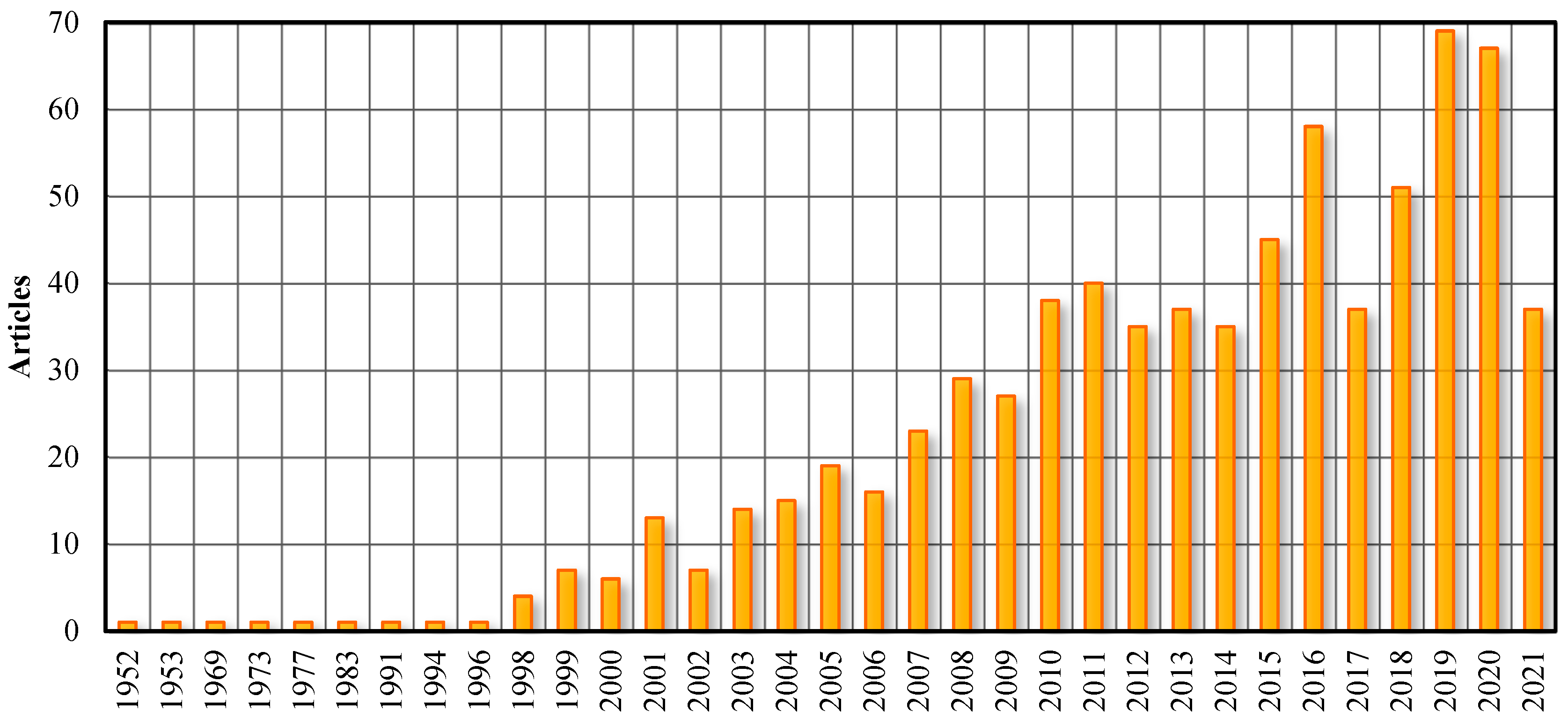
2. Bibliometric Analysis

Based on the Web of Science core collection database, the literature on urban sprawl in the English language was searched using the formula: “Topic = urban sprawl AND Title = sprawl”, resulting in 738 articles in total. The retrieval date was 6 July 2021. On the basis of the 738 documents, the method of bibliometric analysis was adopted to count the annual number of publications, extract keywords, obtain major research areas, and draw the cooperation network map.
The distribution of publication time (Figure 1) shows that urban sprawl research first appeared after World War II and entered a rapid growth phase in the late 1990s. The average annual growth of urban sprawl literature from 1999 to June 2021 was over 31 articles. The research started earliest in the United States, followed by Canada. After entering the 21st century, sprawl research developed very rapidly in the United Kingdom, China, Spain, Germany, Italy, and India. It is worth noting that developing countries are gradually emerging as important battlegrounds for international urban sprawl research [9,10,45,46].
As shown in the keywords and research areas of urban sprawl (Figure 2 and Figure 3), urban sprawl emerges as a special pattern of “urban growth” [47] and “urban expansion” [48], which is inseparable from “urban form” [49], “land use” [47,50], or “land use change” [51,52]. The most influential articles devoted to the effects of urban sprawl—e.g., [27,28,31,32,53,54]—such as public health problems, air quality, energy consumption, ecology and resource conservation, etc. The relationships between urban sprawl and “sustainability” [42], “obesity” [55,56], and “built environment” [31] have received much attention, and the research perspectives are becoming more and more innovative.
Other high-cited literature focuses on the measurement approaches and characteristics of urban sprawl—e.g., [23,32,57]—which significantly advanced the development of urban sprawl measurement studies worldwide. Following these early studies, empirical studies—e.g., [9,38,58,59,60]—emerged and ranked into the top 20 cited articles successively. The corresponding keywords of measuring techniques and methods, such as geographic information systems (“GIS”) [61], “remote sensing” [16,62,63], and “landscape metric” [64], have been widely used.

3. The Definition of Urban Sprawl

3.1. Consensus on the Multidimensionality

Ever since urban sprawl entered the limelight, its definition has attracted the interest of numerous scholars. As a growing understanding of the multidimensional connotation of urban sprawl [10,38,40,44], scholars have tried to define it in terms of characteristics in different dimensions such as location, density, spatial pattern, land use, impacts, and driving forces [11,12,24,38,43,44,65,66,67,68,69,70]. They contributed to a more diverse and complex definition of urban sprawl. Burchell et al. [24] summarized spatial patterns of urban sprawl as “low density,” “unlimited outward expansion,” “land uses spatially segregated,” “leapfrog development,” and “widespread commercial strip development.” Gillham [71] characterized sprawl as leapfrog development, commercial corridors, low density, separation of land use functions, car-dominated transportation, and minimized public space. Lopez and Hynes [43] summarized the literature that described sprawl as containing one or more of the following elements: “low-density development”, “separation of land uses”, “leapfrog development”, “strip retail development”, “automobile-dependent development”, “development at the periphery of an urban area at the expense of its core”, “employment decentralization”, “loss of peri-urban, rural agriculture, and open space”, and “fragmented governmental responsibility and oversight”. Soule [72] defines urban sprawl as a type of low-density, car-transit-dependent land development that occurs at the urban periphery. Arribas-Bel et al. [41] extracted the most relevant six dimensions that define the concept of urban sprawl, the category of urban morphology includes “scattering”, “connectivity “, and “availability of open space”; meanwhile, the category of the internal composition includes “density”, “decentralization”, and “land-use mix”. Gielen et al. [3] delineated urban sprawl as an expansion of population from an urban center to a peripheral residential area that is characterized by lower population density, more open space, single-family houses, lofty buildings, and car-dependent transportation. Fuladlu et al. [10] summarized the views of most scholars that sprawl is unplanned, land-consuming, low-density, single-use, car-dependent, noncontiguous, or leapfrog characteristics.
A number of scholars have emphasized the necessity of simplifying the definition of urban sprawl, in spite of the basic consensus on its multidimensional connotation. Many concepts of urban sprawl involve either causes or outcomes [9]. Unplanning is one of the causes of urban sprawl, while the decline of the urban center is one of the consequences of urban sprawl, in some countries or regions. However, some scholars oppose such definitions, arguing that “the causes and consequences of urban sprawl are not the same as the phenomenon of urban sprawl itself and should not be included in the concept of sprawl” [34,59]. The various and diverse causes and effects of urban sprawl are difficult to be covered in a single conceptual definition. Therefore, it is not appropriate to adopt them as criteria for determining sprawl, nor to put them into the definition as a core characteristic of sprawl. Some studies conducted by international agencies prefer to use simplified concepts, such as defining urban sprawl based on the core dimension of low density. For example, the EEA [34] and OECD [42] define urban sprawl as a pattern of urban development characterized by low population density, but also indicate that there are a variety of manifestations of urban sprawl.

3.2. A Definition Based on Common Features of Sprawl

Urban sprawl differs in performance, effects, and causes among various contexts. In the United States, it is a process of excessive suburbanization dominated by suburban low-density settlements [65,67,72], characterized by social differentiation under racism [71], low-density development and strict land use separation under zoning regulations [8], dependence on car commuting [14,73], and stagnant development of urban centers [14,43]. The characteristics of urban sprawl in the United States were considered as the typical features of urban sprawl [74], and thus were widely referenced to define sprawl. However, the characteristics of urban sprawl are not uniform throughout the world [1,59], and there are nonnegligible geographical differences [34]. A series of studies on urban sprawl by the European Environment Agency (EEA) showed that the degrees of low density, fragmentation, and dependence on automobiles in European cities were less than in the United States [5,34,74]. The phase of urbanization and population base in developing countries differs significantly from that of developed countries. Cities in many developing countries are much denser, such as China, with vibrant urban centers [75]. Suburbanization in the United States is characterized by the migration of elites to low-density, suburban residential areas and the clustering of people of color and low-income classes in decaying central areas. Urban sprawl in some developing countries is dominated by the uncontrolled growth of informal settlements, accompanied by poverty, unemployment, environmental degradation, and inadequate water and sanitation [76]. Taking China as an example, the country has experienced a particularly complicated process of urban sprawl in terms of characteristics [77], with the coexistence of leapfrog industrial parks and university towns, low-density residential communities in a discrete manner from existing urban centers, and informal development in semi-urbanized areas [78].
In this regard, it is necessary to provide a definition based on the common characteristics of urban sprawl in different periods and different countries or regions. The unique characteristics of regions must be accounted for when a study seeks to operationalize urban sprawl [1]. Meanwhile, it is necessary to stress generalities and underplay diversity to draw on the definitions of urban sprawl by Western scholars [74]. The most frequently identified features of urban sprawl can be divided into two categories [8,59,74]:
  • Common features, such as low-density development, homogeneous land use, fragmented and scattered patterns, poor accessibility, etc. Nevertheless, the standards for common features of urban sprawl differ among countries and regions. For example, urban sprawl could also take place in high-density countries, which suffer from constraints of the large population but limited arable land, and land expanding faster than population growth (a manifestation of low density) may cause more serious urban problems there, which should be paid more attention to. Therefore, just like uniform standards for city size in different countries, there is no one-size-fits-all standard in defining urban sprawl features.
  • Differentiated features, such as the decay of urban centers and little planning control. As noted by an EEA report, “the aspect of little planning control with regard to land subdivisions does not always apply, since various areas that are affected by urban sprawl have been planned in this way” [34]. Despite China’s strict arable land protection system and urban planning controls, the failure of these policies has exacerbated urban sprawl [60,78]. Urban sprawl can result either from no plan or as a derivative of proactive planning policies, or even as a consequence of policy failure.
This paper provides a definition of urban sprawl, taking whether the performance of spatial expansion meets the common features of urban sprawl as the criterion: “Urban sprawl is a pattern of urban spatial expansion that is low-density, discontinuous, and homogeneous in land use.”

4. Multidimensional Measurements and Comparative Studies

In practice, the approaches to measuring urban sprawl are primarily based on indicator measures. The single-dimension approach selects one of the most important dimensions to measure the degree of sprawl [7,43], while the multidimensional approach selects indicators of multiple dimensions to calculate an integrated sprawl index [38,40]. The comparative approach is also an auxiliary method for urban sprawl measurement studies, which can be divided into two categories: horizontal comparative studies of multiple cases and vertical comparative studies of an individual case.

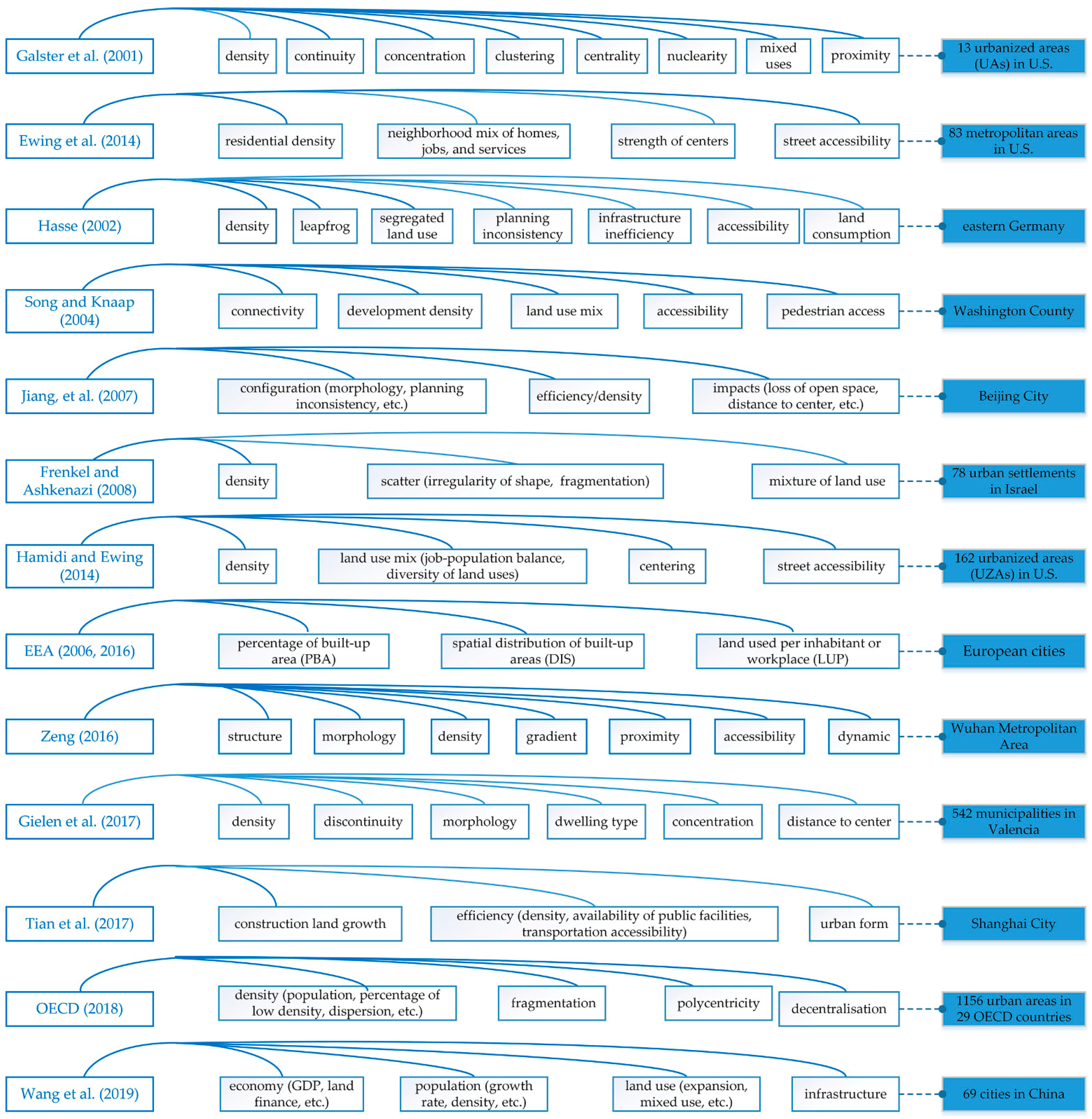
4.1. Multidimensional Metrics

  • Growth: Sprawl is an “excessive” mode of urban growth [23], a situation that the expansion of urban area far exceeds population growth [12,14]. The growth ratio (or deviation) of urban built-up area to population, therefore, is widely used as a measure of sprawl in previous studies—e.g., [7,43,73]. In some cases, e.g., [79,80], the growth of urban population would be applied to measure sprawl, as well as the growth of urban construction land/built-up area/impervious surface, or the loss of open space.
  • Morphology: Sprawl refers to a scattered and discontinuous pattern [38]. Morphological indices consist of discontinuity [3,40], leapfrog [81,82], fractal dimension [42,63], shape index [3,38], etc., which quantify the degree of dispersion and fragmentation of urban landscapes. Additionally, the polycentricity index is also used to measure sprawl [40,42].
  • Density: Sprawl is characterized as low density [10,43], or a tendency of decreasing density over a certain period of time [38]. There are many ways to express it, e.g., population density [12,79], employment density [83], residents density [5], density gradient [84,85], the percentage of the population living in areas with densities below a certain threshold [42], etc.
  • Land use mixture: Sprawl has the traits of separated land use functions, homogeneity and poor diversity of land uses [11,38,44,86]. This mixture of land uses is generally quantified by the percentage of different land uses [38,87], diversity index [58,88], and job–population balance [14,44].
  • Accessibility: Sprawl is a situation of poor accessibility, resulting from morphological discontinuities and a low mixture of land uses [38]. Poor accessibility implies long commuting distances to destinations and low walkability [1,8], which usually results in heavy dependence on cars for daily trips [14,73]. Accessibility indicators include distance/proximity to centers [3,85], road/transit infrastructure accessibility [80,82], pedestrian access [49], etc.
  • Other dimensions, such as aesthetics, planning inconsistency, etc.: The aesthetic dimension has rarely been applied because it is highly subjective [38,69]. Planning inconsistency indicators have also been used to measure urban sprawl in some studies that consider “no plan” as a trait of urban sprawl—e.g., [60,82]. In many cases, the efficiency dimension is also included, consisting of a GDP metric [89] and metrics that borrow from other dimensions [80,85,90].

4.2. Single-Dimensional Measures in Large-Sample Comparative Studies

The primary quantitative studies on sprawl have mainly adopted the single-dimensional measurement approach by selecting one of the most important dimensions to represent urban sprawl [43]. The indicators chosen for single-dimensional measurement approaches have relatively high homogeneity. In general, statistical yearbook data such as population and built-up area are widely used, which are readily available and simple to calculate. For instance, population density or the ratio of urban land extension to population growth is usually used as the measure [40]. As such, single-dimensional measurements are more replicable and comparable.
Representative studies on the single-dimensional measurement of urban sprawl usually involve a large sample of metropolitan areas or cities. For example, Fulton et al. [12] employed population density to assess the levels of sprawl in 281 U.S. metropolitan areas. A sprawl index reflecting the spatial distribution of residential density was proposed by Lopez and Hynes [43] and was used to evaluate the levels of sprawl in 330 U.S. metropolitan areas. Statistical data are limited by administrative boundaries, and the spatial extent of cities is often imprecise [91]. Instead of relying on statistical data, Sutton [91] measured the areal extent of the urban areas using nighttime satellite imagery (DMSP OLS), compared to the corresponding population from the census dataset, and finally used a formula describing the relationship between the population and areal extent of these urban areas to assess urban sprawl. Similarly, Gao et al. [7] calculated the sprawl index for 657 Chinese cities based on the urban built-up area extracted from night light data, normalized vegetation index, and surface temperature. Nevertheless, the single-dimensional measurement approach fails to comprehensively capture the multidimensional features of sprawl [38].

4.3. Booming Comparative Studies Based on Multidimensional Measures

Compared to single-dimensional measurement, multidimensional measures enable a relatively comprehensive capture of the attributes and characteristics of urban sprawl. Subsequently, a number of researchers have attempted to employ multidimensional indicators to measure urban sprawl (Figure 4). Due to the difficulty of data acquisition and calculation, the selection of dimensions and indicators should be based on the core connotation of urban sprawl to ensure the scientific accuracy and representativeness of the indicators. Among the generally used dimensions of measures, density and morphology are the most commonly used ones, whereas land use mix and accessibility may not be included in multi-case studies due to the constraints of data acquisition [40].
There are numerous multidimensional measurement studies based on a single city sample—e.g., [49,60,80,82]. Meanwhile, a large number of comparative studies with large samples using multidimensional measures of urban sprawl booms. Galster et al. [40] proposed an approach consisting of eight dimensions, i.e., density, continuity, concentration, clustering, centrality, nuclearity, mixed uses, and proximity, among which the dimensions of continuity and mixed uses were not utilized in their case study for 13 metropolitan areas in the United States. Ewing et al. [14] used indicators of residential density, functional mixture, the vitality of central areas, and accessibility of road networks to evaluate the sprawl levels of 83 metropolitan areas in the United States. Frenkel and Ashkenazi [38] measured the sprawl of 78 residential areas in Israel using dimensions of density, scatter, and land use composition. Authors of [1] measured urban sprawl in 162 metropolitan areas in the United States using four dimensions: development density, land use mix, centrality, and street accessibility. The EEA [34] calculated a composite index (WUP) to evaluate the degree of sprawl in 32 EU countries based on indicators of three dimensions, namely percentage of built-up area, degree of urban dispersion, and land uptake per person (inhabitants and jobs). Most of them are conducted by renowned scholars or institutions in the field that have great international influence.
Due to the numerous dimensions and indicators involved in multidimensional measurement, researchers usually use various methods to standardize the indicators, so as to reduce redundancy, and cluster multidimensional features into an integrated sprawl index [3]. For example, Galster et al. [40] applied the Z-score method to sum the Z-values of multidimensional indicators to obtain a composite sprawl index. Jiang et al. [92] employed hierarchical analysis (a subjective scoring method in which the weights of factors are obtained by pairwise comparison of factors) to weigh and sum the indicators to obtain a composite spread index. Ewing et al. [14], Frenkel and Ashkenazi [38], Liu and Tan [93], and Wang et al. [79] selected the method of principal component analysis (PCA) to obtain principal component factors from multiple indicators and used the variance contributions of the component factors as the weight coefficients to obtain an integrated sprawl index.

5. Multiple Spatiotemporal Scales of Sprawl Measurements

Urban sprawl has dual attributes, which are temporal and spatial properties [9,74]. Whether a land patch or grid will sprawl in the next time period depends on its past state and the state of its surrounding patches or grids, and thus the temporal and spatial properties are inextricably linked. Therefore, it is necessary to capture and compare the relative sprawl intensity at different times or in different regions [94]. Researches on urban sprawl measurement constitute different spatiotemporal combinations in terms of the choice of temporal and spatial scales (Table 1).

5.1. Diversification of Time Scales

As a noun, sprawl can be used to describe a state, while as a verb it is a process of change [34,42]. Some argued that sprawl is a stage of “natural urban development” that may start in a compact form, then disperse as the population and economy grow, and after a period of time, the sprawling area turns into a more compact area again through infill, parcel subdivision, and higher-density development [34].
In terms of the time scales in sprawl measurements, there are both horizontal comparations and longitudinal comparations. Horizontal comparative studies reveal the statuses of urban sprawl at a single time, e.g., [40,43,44]. Longitudinal comparative studies analyze the dynamic variation of urban sprawl under successive periods, e.g., [93]. There are also studies combining horizontal and vertical comparative analysis—e.g., [12,14,34,38,79,95]. Yet, in general, the divergent patterns in the choice of time scale among different studies are not apparent. Since urban sprawl is a relative concept, many studies have used relative indicators from the current year to the base year (requiring two periods of data) to describe it, such as indicators of growth rates. Wang et al. [79] calculated the population growth rate and construction land growth rate for 2004, 2009, and 2014 using 2000 as the base period, and other indicators not directly expressed as growth rates were calculated using the ratio of the current value of the indicator to the base period value. Moreover, among those studies that used relative indicators, some carried out longitudinal comparisons [79,80,95], while others conducted horizontal comparative analyses [7,60,92].

5.2. Diversification of Spatial Scales

In terms of spatial scales, the evaluation units of sprawl can be simply divided into two categories: macro- and micro-scale. The measuring units of macro-scale studies generally consist of country [42], metropolitan area [12], and city [7]. Most of the macro-scale studies conducted horizontal comparative analyses using a range of city cases [3,7,43,44]. Several studies conducted both horizontal and longitudinal comparative analyses for multiple sample cases [12,14,79,95]. Additionally, a few macro-scale studies compare longitudinally on a single-city sample [93].
The development of micro-scale studies on urban sprawl measurement was once slow due to the high cost and difficulty of acquiring data on intracity units. With the advancing GIS technology, micro-scale measurement studies are becoming increasingly enriched. Existing studies on micro-scale measurement of urban sprawl can generally be divided into three categories: intracity administrative unit [49,60], residential area [38], or plot or grid, delineated according to certain rules [34,85]. The measuring units of micro-scale studies rely on the smallest unit of accessible data and need to be traded off between the amount of data processing and sprawl information measured at different levels. For example, Song and Knaap [49] compared the efficiency of three measuring units, namely census tracts, blocks, and subblocks. It was found that the census tract level provided less information about spatial changes over time than the block level, while the subblock level did not return much more information than that at the block level. They finally chose the block level and selected indicators that were suitable for this spatial scale, consisting of road accessibility within blocks, road accessibility between blocks, the average number of blocks, and the mixture index of nonresidential land within blocks.

5.3. The Lack of Multiscale Measurements

Most studies are based on a single scale, and very few have measured and compared urban sprawl at multiple scales simultaneously. An exception to this is that the EEA [34] conducted a measurement of sprawl at three spatial scales: country level, regions/provinces/states/prefectures with a population of between 800,000 and 3 million, and 1 km2 grid level, and compared the changes in sprawl levels for each scale between 2006 and 2009, respectively. Additionally, Zeng [85] proposed a multilevel and multidimensional approach to measuring urban sprawl, and calculated the sprawl indices in 1996 and 2006 for three spatial scales: macro-level (Wuhan metropolitan area), meso-level (districts and counties), and micro-level (plot units), respectively. Overall, multiscale measurement based on horizontal comparison and longitudinal comparison has been one of the shortcomings of existing sprawl measurement studies.

6. Challenges and Future Perspective

  • Relativity and uncertainty of sprawl criteria: Sprawl is the opposite of compact [5]. From the ‘compact’ form to the ‘sprawl’ form is likely to be moving in a direction in a continuum [38,54,96]. There is a gradient between low and high levels of sprawl [34]. In other words, sprawl is a matter of degree [8]. However, it is impossible to identify an absolute threshold to determine whether a city is sprawling when it is above or below that degree. In particular, the relationship between polycentricity and sprawl is still controversial. Gordon and Richardson [97] noted that compact cities are high-density or monocentric, while Anderson et al. [98] thought compact cities can be monocentric or polycentric in morphology. Some studies have argued that the boundary between scattered development and polycentric development is uncertain [8,99]: scattered development is the typical type of sprawl, which is inefficient in terms of infrastructure and public service provision, whereas polycentric development is less prone to agglomeration diseconomies and can even be more efficient than the monocentric mode if the metropolitan areas grow beyond a certain scale [100]. Such fuzziness raises the unpredictability of sprawl degrees when using polycentricity as a measure. Therefore, specific research on the differentiated scenarios and the corresponding criteria would contribute to a more precise assessment of urban sprawl.
  • Strong dependence on the choice of spatiotemporal scales: Observations at a certain scale can only reflect the patterns and processes at that observed scale [34]. Among the longitudinal studies, the longer time interval used is around 15 years [12,38], the medium time interval is around 10 years [14], and the shorter time interval is 5 years or less [79,95]. The magnitude and criteria of urban sprawl may change over different time intervals. For example, leapfrog development is considered inefficient in the short term, while edge growth and infill growth may make leapfrog urban land patches continuous and reasonable in the long term; hence, longer time intervals loses this valuable information about the change [8]. However, if the time interval is too short, the urban sprawl condition has a large randomness [95]. This scale effect is more noticeable in terms of spatial scales. What is considered "reasonable" planning at the micro-scale may manifest itself as uncontrolled sprawl development at the macro-scale. When observed at the city level, sprawl may be overestimated due to the distance of subcenters and new towns from the main city center. However, at the level of subcenters, the sprawl characteristics become less prominent as they highlight their role as new growth poles for the surrounding population and economic activities. Therefore, it is essential to choose a moderate combination of temporal and spatial scales when conducting longitudinal studies [95].
  • Comparability of sprawl measurements remains to be improved. Theoretically, the results of single-dimensional and multidimensional measurements should have a certain consistency, and multidimensional measurements can complement single-dimensional measurements [101]. In practice, however, the comparability between the results of different studies is unsatisfactory because of the differences in measurement periods, cases, measurement methods, and data sources. For example, the following studies provided significantly different results, which used different measurement methods with a partial overlap of time periods and cases. Gao et al. [7] calculated the sprawl levels of 657 cities in China from 1990 to 2010 using the growth ratio metric. They found that the sprawl levels of large cities and megacities were lower than those of medium and small cities, and the sprawl of medium and small cities in West China was the most serious. Wang et al. [79] measured the sprawl levels of 69 large and medium cities in China from 2000 to 2014, applying a multidimensional sprawl index comprising population, economy, land use, and infrastructure. The results showed that the sprawling level from high to low is ranked as megacities with rapid growth of population and economy, large and medium cities with relatively developed economies, and cities in lagging and slow development areas. In addition, the replicability and comparability of multidimensional measurements are greatly reduced by the different dimensions and indicators selected, the availability of data, and the complexity of calculations. Sufficient and differentiated sample case studies is of great importance to verify the replicability of the multidimensional measurement approach and the comparability of the findings.
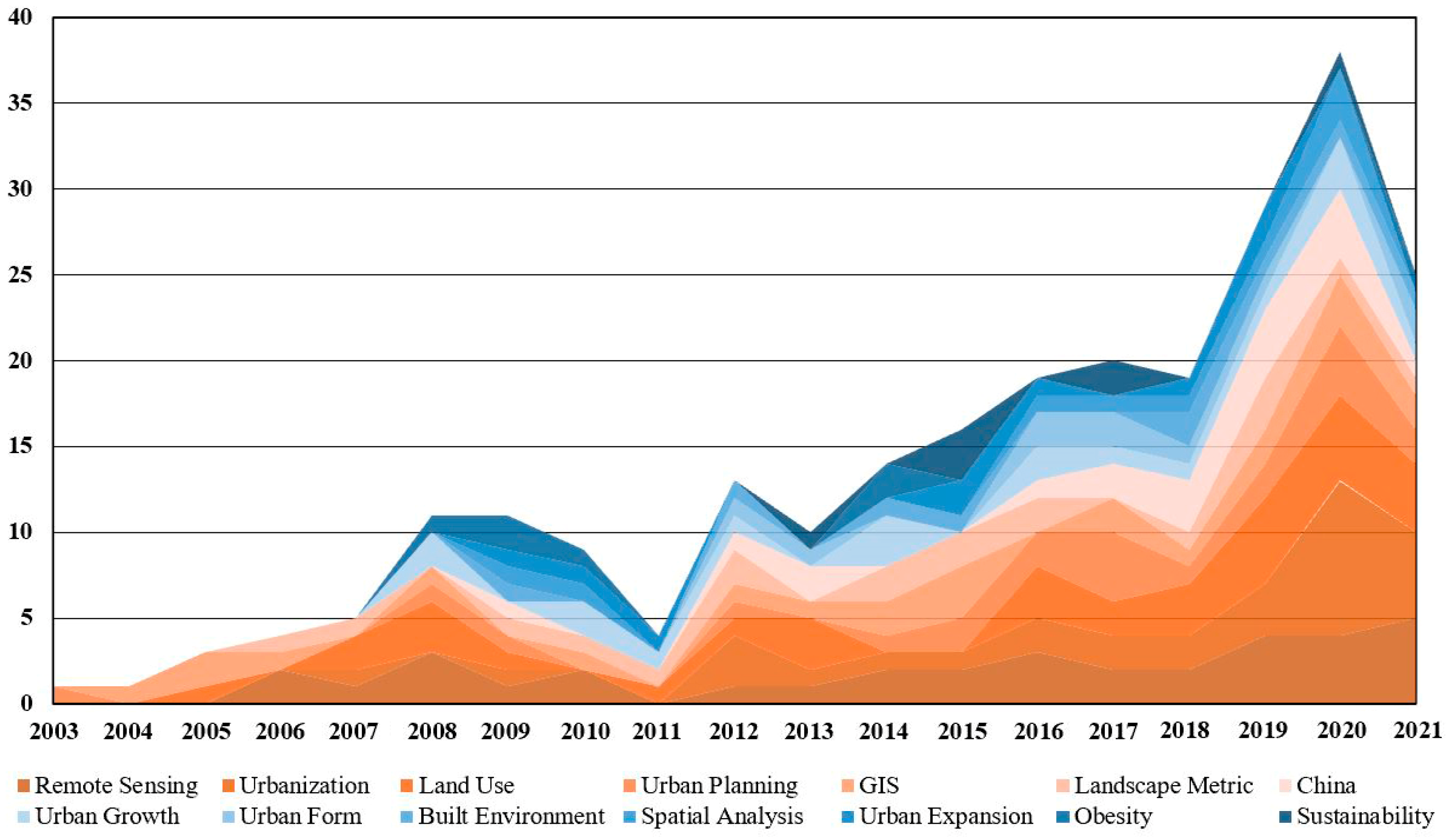
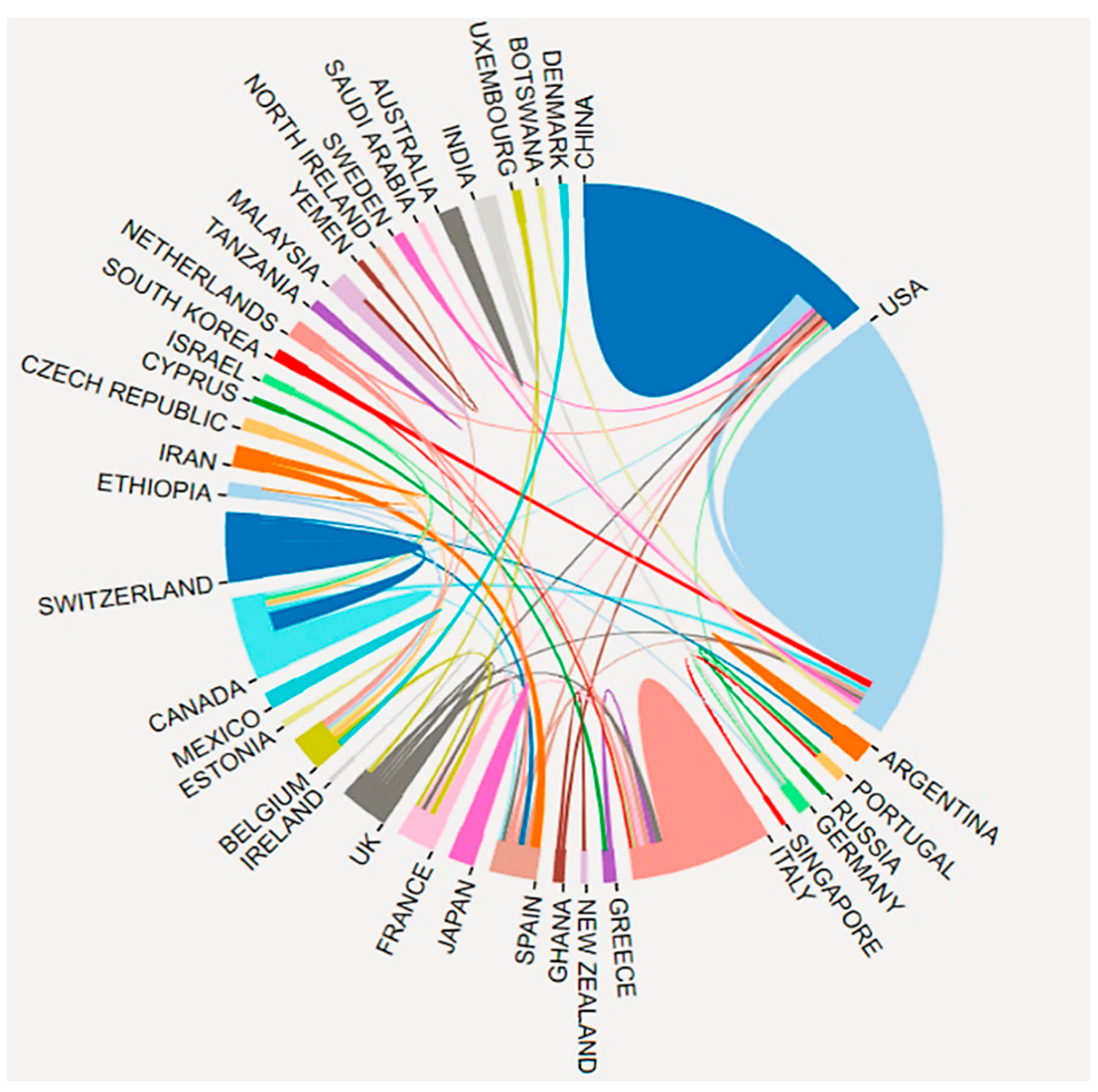
  • Long-term international cooperation on measurement of urban sprawl at the global and regional levels is necessary. Intercountry cooperation in sprawl research is getting closer (Figure 5), especially among United States, China, Italy, Canada, etc. Additionally, scholars have attempted to collaborate with academic institutions or agencies, contributing to several influential reports (Table 2). For instance, the report “Measuring Sprawl and Its Impact” that presented sprawl measures for 83 metropolitan areas in U.S. [14] was accomplished by some renowned scholars from universities and the Smart Growth America (SGA) organization. The report “Urban sprawl in Europe” [34] was a joint report based on the cooperation between the Swiss Federal Institute for Forest (FOEN) and European Environment Agency (EEA), which focuses on the sprawl measures for European cities. There is much room for further improvement in the international cooperation of multidimensional and multiscale measurement that covers more regions and contexts, developing countries in particular.

7. Conclusions

This article presents a thorough review of the literature on urban sprawl from the perspective of multidimensional and multiscale measurement. The conclusions are drawn as follows: Firstly, in a systematic study of urban sprawl, the definition of its multidimensional connotation is the most fundamental prerequisite. The differences in national contexts raise a great challenge to the definition and measurement of urban sprawl. Early American scholars and planners defined urban sprawl based on the characteristics exhibited by sprawl cases in their own country, which were disseminated worldwide. However, some of the characteristics of sprawl vary among different national contexts, such as “the decline of urban downtowns” and “low density”, which made the definitions not apply to all national contexts, especially the developing countries. It is necessary to document the characteristics of urban sprawl in the context of developing countries, contributing a definition and a measurement that are universal and comparable.
Secondly, more case studies are required to verify the multidimensional approach of sprawl measurement. In general, multi-case comparative studies are always confined to single-dimensional measurement, while multidimensional measurement methods are mainly used in single-case studies. Furthermore, existing empirical studies have underperformed in terms of comparability due to the differences in measurement periods, case samples, dimensions, metrics, and data sources. Therefore, the selection of dimensions and indicators should be based on the core connotation of urban sprawl. Exploring more multidimensional and multi-case empirical studies on measuring urban sprawl, especially in the developing context, is essential to advance the process of urban sprawl research.
Thirdly, there are large gaps in multiscale comparative studies of urban sprawl. In terms of time scales, it has been well studied both for the state of urban sprawl under a single time period and for the dynamic trends of urban sprawl under multiple consecutive time periods. At the spatial scale, macro-scale studies that compare the sprawl levels of single or multiple cities, metropolitan areas, and countries dominate. In contrast, there are relatively few micro-scale studies that focus on inner-city units, such as streets and towns, neighborhoods, and grids. Despite the increasing diversity in the temporal and spatial scales of urban sprawl measurement, most of these attempts have been scattered in different studies. Few of these studies can quantitatively analyze urban sprawl at multiple scales simultaneously. Therefore, a multidimensional and multiscale urban sprawl measurement study based on multi-case comparisons would fill the gap in the literature.

Author Contributions

Conceptualization, L.Z. (Linlin Zhang); methodology, L.Z. (Linlin Zhang) and X.S; resources, L.Z. (Linlin Zhang); writing—original draft preparation, L.Z. (Linlin Zhang) and X.S.; writing—review and editing, L.Z. (Linlin Zhang) and L.Z. (Liang Zhang); project administration, L.Z. (Linlin Zhang) and L.Z. (Liang Zhang). All authors have read and agreed to the published version of the manuscript.

Funding

This research was funded by Zhejiang Provincial Philosophy and Social Sciences Planning Project (Grant No. 20NDQN294YB), Major Humanities and Social Sciences Research Projects in Zhejiang higher education institutions (Grant No. 2023QN107), Natural Science Foundation of Zhejiang Province (Grant No. LQ20D010004), and Zhejiang Provincial Philosophy and Social Sciences Planning Project (Grant No. 21NDQN270YB).

Institutional Review Board Statement

Not applicable.

Informed Consent Statement

Not applicable.

Data Availability Statement

Not applicable.

Conflicts of Interest

The authors declare no conflict of interest.

References

  1. Hamidi, S.; Ewing, R. A Longitudinal Study of Changes in Urban Sprawl between 2000 and 2010 in the United States. Landsc. Urban Plan. 2014, 128, 72–82. [Google Scholar] [CrossRef]
  2. Herzog, L. Global Suburbs: Urban Sprawl from the Rio Grande to Rio de Janeiro; Routledge: London, UK, 2014. [Google Scholar]
  3. Gielen, E.; Riutort-Mayol, G.; Palencia-Jiménez, J.S.; Cantarino-Martí, I. An urban sprawl index based on multivariate and Bayesian factor analysis with application at the municipality level in Valencia. Environ. Plan. B Urban Anal. City Sci. 2017, 45, 888–914. [Google Scholar] [CrossRef]
  4. Batty, M.; Xie, Y.; Sun, Z. The Dynamics of Urban Sprawl (CASA Paper 15); Centre for Advanced Spatial Analysis: London, UK, 1999. [Google Scholar]
  5. EEA. Urban Sprawl in Europe: The Ignored Challenge (EEA Report No 10/2006); European Commission/Joint Research Centre, European Environment Agency: Copenhagen, Denmark, 2006; ISBN 92-9167-887-2. [Google Scholar]
  6. Marais, L.; Denoon-Stevens, S.; Cloete, J. Mining towns and urban sprawl in South Africa. Land Use Policy 2020, 93, 103953. [Google Scholar] [CrossRef]
  7. Gao, B.; Huang, Q.; He, C.; Sun, Z.; Zhang, D. How does sprawl differ across cities in China? A multi-scale investigation using nighttime light and census data. Landsc. Urban Plan. 2016, 148, 89–98. [Google Scholar] [CrossRef]
  8. Ewing, R.H. Characteristics, Causes, and Effects of Sprawl: A Literature Review. In Urban Ecology: An International Perspective on the Interaction Between Humans and Nature; Marzluff, J.M., Shulenberger, E., Endlicher, W., Alberti, M., Bradley, G., Ryan, C., Simon, U., ZumBrunnen, C., Eds.; Springer: New York, NY, USA, 2008; pp. 519–535. [Google Scholar]
  9. Bhatta, B. Analysis of Urban Growth and Sprawl from Remote Sensing Data; Springer: Berlin, Germany, 2010. [Google Scholar]
  10. Fuladlu, K.; Riza, M.; Ilkan, M. Monitoring Urban Sprawl Using Time-Series Data: Famagusta Region of Northern Cyprus. SAGE Open 2021, 11, 215824402110074. [Google Scholar] [CrossRef]
  11. Ewing, R. Is Los Angeles-Style Sprawl Desirable? J. Am. Plan. Assoc. 1997, 63, 107–126. [Google Scholar] [CrossRef]
  12. Fulton, W.; Pendall, R.; Nguyen, M.; Harrison, A. Who Sprawls Most? How Growth Patterns Differ across the U.S.; Brookings Institution, Center on Urban and Metropolitan Policy: Washington, DC, USA, 2001. [Google Scholar]
  13. Brueckner, J.; Fansler, D.A. The economics of urban sprawl: Theory and evidence on the spatial sizes of cities. Rev. Econ. Stat. 1983, 65, 479–482. [Google Scholar] [CrossRef]
  14. Ewing, R.; Pendall, R.; Chen, D. Measuring Sprawl and Its Impact; Smart Growth America: Washington, DC, USA, 2002. [Google Scholar]
  15. Vermeiren, K.; Crols, T.; Uljee, I.; De Nocker, L.; Beckx, C.; Pisman, A.; Broekx, S.; Poelmans, L. Modelling urban sprawl and assessing its costs in the planning process: A case study in Flanders, Belgium. Land Use Policy 2022, 113, 105902. [Google Scholar] [CrossRef]
  16. Lityński, P.; Houj, A. Macroeconomic Perspective on Urban Sprawl: A Multidimensional Approach in Poland. Land 2021, 10, 116. [Google Scholar] [CrossRef]
  17. Young, M.; Tanguay, G.A.; Lachapelle, U. Transportation costs and urban sprawl in Canadian metropolitan areas. Res. Transp. Econ. 2016, 60, 25–34. [Google Scholar] [CrossRef]
  18. Jargowsky, P.A. Sprawl, Concentration of Poverty, and Urban Inequality. In Urban Sprawl: Causes, Consequences, and Policy Responses; Squires, G.D., Ed.; Urban Institute Press: Washington, DC, USA, 2002. [Google Scholar]
  19. Le Goix, R. Gated Communities: Sprawl and Social Segregation in Southern California. Hous. Stud. 2005, 20, 323–343. [Google Scholar] [CrossRef] [Green Version]
  20. Frumkin, H.; Frank, L.; Jackson, R.J. Urban Sprawl and Public Health: Designing, Planning, and Building for Healthy Communities; Island Press: Washington, DC, USA, 2004. [Google Scholar]
  21. Ewing, R.; Hamidi, S.; Grace, J.B.; Wei, Y.D. Does Urban Sprawl Hold Down Upward Mobility? Landsc. Urban Plan. 2016, 148, 80–88. [Google Scholar] [CrossRef] [Green Version]
  22. Harvey, R.O.; Clark, W.A.V. The Nature and Economics of Urban Sprawl. Land Econ. 1965, 41, 1–9. [Google Scholar] [CrossRef]
  23. Brueckner, J. Urban sprawl: Diagnosis and remedies. Int. Reg. Sci. Rev. 2000, 23, 160–171. [Google Scholar] [CrossRef]
  24. Burchell, R.W.; Shad, N.; Listokin, D.; Phillips, H.; Downs, A.; Seskin, S.; Davis, J.; Moore, T.; Helton, D.; Gall, M. The Costs of Sprawl—Revisited. Report 39. Transit Cooperative Research Program; Transportation Research Board, National Research Council. National Academy Press: Washington, DC, USA, 1998. [Google Scholar]
  25. Chen, D.; Lu, X.; Hu, W.; Zhang, C.; Lin, Y. How urban sprawl influences eco-environmental quality: Empirical research in China by using the Spatial Durbin model. Ecol. Indic. 2021, 131, 108113. [Google Scholar] [CrossRef]
  26. Schweitzer, L.; Zhou, J. Neighborhood Air Quality, Respiratory Health, and Vulnerable Populations in Compact and Sprawled Regions. J. Am. Plan. Assoc. 2010, 76, 363–371. [Google Scholar] [CrossRef]
  27. Stone, B. Urban sprawl and air quality in large US cities. J. Environ. Manag. 2008, 86, 688–698. [Google Scholar] [CrossRef]
  28. Stone, B.; Hess, J.J.; Frumkin, H. Urban Form and Extreme Heat Events: Are Sprawling Cities More Vulnerable to Climate Change Than Compact Cities? Environ. Health Perspect. 2010, 118, 1425–1428. [Google Scholar] [CrossRef] [Green Version]
  29. Singh, R.; Kalota, D. Urban Sprawl and Its Impact on Generation of Urban Heat Island: A Case Study of Ludhiana City. J. Indian Soc. Remote. Sens. 2019, 47, 1567–1576. [Google Scholar] [CrossRef]
  30. Arshad, S.; Ahmad, S.R.; Abbas, S.; Asharf, A.; Siddiqui, N.A.; Islam, Z.u. Quantifying the contribution of diminishing green spaces and urban sprawl to urban heat island effect in a rapidly urbanizing metropolitan city of Pakistan. Land Use Policy 2022, 113, 105874. [Google Scholar] [CrossRef]
  31. Ewing, R.; Meakins, G.; Hamidi, S.; Nelson, A.C. Relationship between urban sprawl and physical activity, obesity, and morbidity—Update and refinement. Health Place 2014, 26, 118–126. [Google Scholar] [CrossRef] [Green Version]
  32. Lopez, R. Urban Sprawl and Risk for Being Overweight or Obese. Am. J. Public Health 2004, 94, 1574–1579. [Google Scholar] [CrossRef] [PubMed]
  33. Popenoe, D. Urban Sprawl-Some Neglected Sociological Considerations. Sociol. Soc. Res. 1979, 63, 255–268. [Google Scholar]
  34. EEA. Urban Sprawl in Europe. Joint EEA-FOEN report. No 11/2016; European Environment Agency: København, Denmark, 2016. [Google Scholar]
  35. Gordon, P.; Richardson, H. Where’s the Sprawl? J. Am. Plan. Assoc. 1997, 63, 275–278. [Google Scholar]
  36. Ingram, G.K. Patterns of Metropolitan Development: What Have We Learned? Urban Stud. 1998, 35, 1019–1035. [Google Scholar] [CrossRef] [Green Version]
  37. Bruegmann, R. Sprawl: A Compact History; University of Chicago Press: Chicago, IL, USA, 2006. [Google Scholar]
  38. Frenkel, A.; Ashkenazi, M. Measuring Urban Sprawl: How Can We Deal With It? Environ. Plan. B Plan. Des. 2008, 35, 56–79. [Google Scholar] [CrossRef] [Green Version]
  39. Ewing, R.; Hamidi, S.; Grace, J.B. Urban Sprawl as a Risk Factor in Motor Vehicle Crashes. Urban Stud. 2016, 53, 53–54. [Google Scholar] [CrossRef] [Green Version]
  40. Galster, G.; Hanson, R.; Ratcliffe, M.R.; Wolman, H.; Coleman, S.; Freihage, J. Wrestling Sprawl to the Ground: Defining and Measuring an Elusive Concept. Hous. Policy Debate 2001, 12, 681–717. [Google Scholar] [CrossRef]
  41. Arribas-Bel, D.; Nijkamp, P.; Scholten, H. Multidimensional urban sprawl in Europe: A self-organizing map approach. Comput. Environ. Urban Syst. 2011, 35, 263–275. [Google Scholar] [CrossRef] [Green Version]
  42. OECD. Rethinking Urban Sprawl Moving Towards Sustainable Cities; OCED Publishing: Paries, France, 2018. [Google Scholar]
  43. Lopez, R.; Hynes, H.P. Sprawl in the 1990s Measurement, Distribution, and Trends. Urban Aff. Rev. 2003, 38, 325–355. [Google Scholar] [CrossRef]
  44. Hamidi, S.; Ewing, R.; Preuss, I.; Dodds, A. Measuring Sprawl and Its Impacts An Update. J. Plan. Educ. Res. 2015, 35, 35–50. [Google Scholar] [CrossRef]
  45. Abu Hatab, A.; Cavinato, M.E.R.; Lindemer, A.; Lagerkvist, C.-J. Urban sprawl, food security and agricultural systems in developing countries: A systematic review of the literature. Cities 2019, 94, 129–142. [Google Scholar] [CrossRef]
  46. Wang, X.; Shi, R.; Zhou, Y. Dynamics of urban sprawl and sustainable development in China. Socio-Econ. Plan. Sci. 2020, 70, 100736. [Google Scholar] [CrossRef]
  47. Sahana, M.; Hong, H.; Sajjad, H. Analyzing urban spatial patterns and trend of urban growth using urban sprawl matrix: A study on Kolkata urban agglomeration, India. Sci. Total Environ. 2018, 628-629, 1557–1566. [Google Scholar] [CrossRef]
  48. Zhao, P. Sustainable urban expansion and transportation in a growing megacity: Consequences of urban sprawl for mobility on the urban fringe of Beijing. Habitat Int. 2010, 34, 236–243. [Google Scholar] [CrossRef]
  49. Song, Y.; Knaap, G. Measuring Urban Form: Is Portland Winning the War on Sprawl? J. Am. Plan. Assoc. 2004, 70, 210–225. [Google Scholar] [CrossRef]
  50. Kovács, Z.; Farkas, Z.J.; Egedy, T.; Kondor, A.C.; Szabó, B.; Lennert, J.; Baka, D.; Kohán, B. Urban sprawl and land conversion in post-socialist cities: The case of metropolitan Budapest. Cities 2019, 92, 71–81. [Google Scholar] [CrossRef]
  51. Salem, M.; Tsurusaki, N.; Divigalpitiya, P. Land use/land cover change detection and urban sprawl in the peri-urban area of greater Cairo since the Egyptian revolution of 2011. J. Land Use Sci. 2020, 15, 592–606. [Google Scholar] [CrossRef]
  52. Dey, J.; Sakhre, S.; Vijay, R.; Bherwani, H.; Kumar, R. Geospatial assessment of urban sprawl and landslide susceptibility around the Nainital lake, Uttarakhand, India. Environ. Dev. Sustain. 2020, 23, 3543–3561. [Google Scholar] [CrossRef]
  53. Frumkin, H. Urban Sprawl and Public Health. Public Health Rep. 2002, 117, 201–217. [Google Scholar] [CrossRef]
  54. Johnson, M.P. Environmental impacts of urban sprawl: A survey of the literature and proposed research agenda. Environ. Plan. A 2001, 33, 717–735. [Google Scholar] [CrossRef] [Green Version]
  55. Eid, J.; Overman, H.G.; Puga, D.; Turner, M.A. Fat city: Questioning the relationship between urban sprawl and obesity. J. Urban Econ. 2008, 63, 385–404. [Google Scholar] [CrossRef] [Green Version]
  56. Ewing, R.; Schmid, T.; Killingsworth, R.; Zlot, A.; Raudenbush, S. Relationship Between Urban Sprawl and Physical Activity, Obesity, and Morbidity. Am. J. Health Promot. 2003, 18, 47–57. [Google Scholar] [CrossRef] [PubMed]
  57. Hasse, J.E.; Lathrop, R.G. Land resource impact indicators of urban sprawl. Appl. Geogr. 2003, 23, 159–175. [Google Scholar] [CrossRef]
  58. Jat, M.K.; Garg, P.K.; Khare, D. Monitoring and Modelling of Urban Sprawl Using Remote Sensing and GIS Techniques. Int. J. Appl. Earth Obs. Geoinf. 2008, 10, 26–43. [Google Scholar] [CrossRef]
  59. Jaeger, J.; Bertiller, R.; Schwick, C.; Kienast, F. Suitability criteria for measures of urban sprawl. Ecol. Indic. 2010, 10, 397–406. [Google Scholar] [CrossRef]
  60. Yue, W.; Liu, Y.; Fan, P. Measuring Urban Sprawl and Its Drivers in Large Chinese Cities: The Case of Hangzhou. Land Use Policy 2013, 31, 358–370. [Google Scholar] [CrossRef]
  61. Steurer, M.; Bayr, C. Measuring urban sprawl using land use data. Land Use Policy 2020, 97, 104799. [Google Scholar] [CrossRef]
  62. Magidi, J.; Ahmed, F. Assessing urban sprawl using remote sensing and landscape metrics: A case study of City of Tshwane, South Africa (1984–2015). Egypt. J. Remote Sens. Space Sci. 2019, 22, 335–346. [Google Scholar] [CrossRef]
  63. Chettry, V.; Surawar, M. Assessment of urban sprawl characteristics in Indian cities using remote sensing: Case studies of Patna, Ranchi, and Srinagar. Environ. Dev. Sustain. 2021, 23, 11913–11935. [Google Scholar] [CrossRef]
  64. Getu, K.; Bhat, H.G. Analysis of spatio-temporal dynamics of urban sprawl and growth pattern using geospatial technologies and landscape metrics in Bahir Dar, Northwest Ethiopia. Land Use Policy 2021, 109, 105676. [Google Scholar] [CrossRef]
  65. Clawson, M. Urban Sprawl and Speculation in Suburban Land. Land Econ. 1962, 38, 99–111. [Google Scholar] [CrossRef]
  66. Ottensmann, J.R. Urban Sprawl, Land Values and the Density of Development. Land Econ. 1977, 53, 389–400. [Google Scholar] [CrossRef]
  67. Downs, A. New Visions for Metropolitan America; Brookings Institution & Lincoln Institute of Land Policy: Cambridge, MA/Washington, DC USA, 1994. [Google Scholar]
  68. Ewing, R. Characteristics, causes, and effects of sprawl: A literature review. Environ. Urban Issues 1994, 21, 1–15. [Google Scholar]
  69. Torrens, P.M.; Alberti, M. Measuring Sprawl (CASA Paper 27); Centre for Advanced Spatial Analysis: London, UK, 2000. [Google Scholar]
  70. Amarawickrama, S.; Singhapathirana, P.; Rajapaksha, N. Defining Urban Sprawl in the Sri Lankan Context: With Special Reference to the Colombo Metropolitan Region. J. Asian Afr. Stud. 2015, 50, 590–614. [Google Scholar] [CrossRef]
  71. Gillham, O. The Limitless City: A Primer on the Urban Sprawl Debate; Island Press: Washington, DC, USA, 2002. [Google Scholar]
  72. Soule, D.C. Defining and Managing Sprawl. Urban Sprawl: A Comprehensive Reference Guide; Greenwood Press: Westport, CT, USA, 2006. [Google Scholar]
  73. Sierra Club. The Dark Side of the American Dream: The Costs and Consequences of Suburban Sprawl; Sierra Club: College Park, MD, USA, 1998. [Google Scholar]
  74. Couch, C.; Leontidou, L.; Petschel-Held, G. (Eds.) Urban Sprawl in Europe: Landscapes, Land-Use Change and Policy; Blackwell Publishing Ltd: Oxford, UK, 2007. [Google Scholar]
  75. Yeh, A.G.-O.; Xia, L. Measurement and monitoring of urban sprawl in a rapidly growing region using entropy. Photogramm. Eng. Remote Sens. 2001, 67, 83–90. [Google Scholar]
  76. UN-Habitat. World Cities Report 2016: Urbanization and Development-Emerging Futures; United Nations Human Settlements Programme (UN-Habitat): Nairobi, Kenya, 2016. [Google Scholar]
  77. Deng, F.F.; Huang, Y. Uneven Land Reform and Urban Sprawl in China: The Case of Beijing. Prog. Plan. 2004, 61, 211–236. [Google Scholar] [CrossRef]
  78. Liu, Y.; Fan, P.; Yue, W.; Song, Y. Impacts of land finance on urban sprawl in China: The case of Chongqing. Land Use Policy 2018, 72, 420–432. [Google Scholar] [CrossRef]
  79. Wang, J.; Xie, Y.; Ma, H.; Siyuan, C. Measuring China’s urban sprawl in the rapid urbanization period by multi-indicator index method. Plan. Stud. 2019, 43, 9–19. (In Chinese) [Google Scholar]
  80. Tian, L.; Li, Y.; Yan, Y.; Wang, B. Measuring urban sprawl and exploring the role planning plays: A Shanghai case study. Land Use Policy 2017, 67, 426–435. [Google Scholar] [CrossRef]
  81. Xu, C.; Liu, M.; Zhang, C.; An, S.; Yu, W.; Chen, J.M. The spatiotemporal dynamics of rapid urban growth in the Nanjing metropolitan region of China. Landsc. Ecol. 2007, 22, 925–937. [Google Scholar] [CrossRef]
  82. Hasse, J.E. Geospatial Indices of Urban Sprawl in New Jersey; The State University of New Jersey: New Jersey, NJ, USA, 2002. [Google Scholar]
  83. Jaeger, J.; Schwick, C. Improving the Measurement of Urban Sprawl: Weighted Urban Proliferation (WUP) and Its Application to Switzerland. Ecol. Indic. 2014, 38, 294–308. [Google Scholar] [CrossRef]
  84. Batty; Longley, M. Fractal Cities-A Geometry of Form and Function; Academic Press Professional Inc.: Cambridge, MA, USA, 1994. [Google Scholar]
  85. Zeng, C. Multi-Level Multi-Dimensional Measurement of Urban Sprawl and Multi-Scale Multi-Strategy Spatial Regression Modeling; Science Press: Beijing, Chinese, 2016. [Google Scholar]
  86. Feng, L.; Du, P.J.; Li, H.; Zhu, L.J. Measurement of Urban Fringe Sprawl in Nanjing between 1984 and 2010 Using Multidimensional Indicators. Geogr. Res. 2015, 53, 184–198. [Google Scholar] [CrossRef]
  87. McGarigal, K.; Marks, B.J. FRAGSTATS—Spatial Pattern Analysis Program for Quantifying Landscape Structure; Department of Agriculture, Forest Service, Pacific Northwest Research Station: Portland, OR, USA, 1995. [Google Scholar]
  88. Pradhan, B. Spatial Modeling and Assessment of Urban Form: Analysis of Urban Growth: From Sprawl to Compact Using Geospatial Data; Springer International Publishing: New York, NY, USA, 2017. [Google Scholar]
  89. Yue, W.; Wu, T.; Liu, X.; Zhang, L.; Wu, C.; Ye, Y.; Zheng, G. Developing an urban sprawl index for China’s mega-cities. Acta Geogr. Sin. 2020, 75, 2730–2743. (In Chinese) [Google Scholar]
  90. Jia, M.; Zhang, H.; Yang, Z. Compactness or sprawl: Multi-dimensional approach to understanding the urban growth patterns in Beijing-Tianjin-Hebei region, China. Ecol. Indic. 2022, 138, 108816. [Google Scholar] [CrossRef]
  91. Sutton, P. A scale-adjusted measure of “urban sprawl” using nighttime satellite imagery. Remote Sens. Environ. 2003, 86, 353–369. [Google Scholar] [CrossRef]
  92. Jiang, F.; Liu, S.; Yuan, H. Measuring Urban Sprawl in Beijing with Geo-spatial Indices. Acta Geogr. Sin. 2007, 62, 649–658. (In Chinese) [Google Scholar] [CrossRef]
  93. Liu, W.; Tan, R. Evaluation System and Control Mechanism of Urban Sprawl: A Case Study of Hangzhou. Acta Geogr. Sin. 2009, 64, 417–425. (In Chinese) [Google Scholar]
  94. Wilson, E.H.; Hurd, J.D.; Civco, D.L.; Prisloe, M.P.; Arnold, C. Development of a geospatial model to quantify, describe and map urban growth. Remote Sens. Environ. 2003, 86, 275–285. [Google Scholar] [CrossRef]
  95. Zhang, X.; Lu, L.; Ren, Y.; Xu, Y.; Zhang, H. Spatiotemporal Evolution Pattern of Urban Sprawl in China and Its Influencing Factors. Econ. Geogr. 2021, 41, 77–85. (In Chinese) [Google Scholar]
  96. Pendall, R. Do Land-use Controls Cause Sprawl? Environ. Plan. B Plan. Des. 1999, 26, 555–571. [Google Scholar] [CrossRef] [Green Version]
  97. Gordon, P.; Richardson, H.W. Are Compact Cities a Desirable Planning Goal? J. Am. Plan. Assoc. 1997, 63, 95–106. [Google Scholar] [CrossRef]
  98. Anderson, W.P.; Kanaroglou, P.S.; Miller, E.J. Urban form, energy and the environment: A review of issues, evidence and policy. Urban Stud. 1996, 33, 7–35. [Google Scholar] [CrossRef]
  99. Gordon, P.; Wong, H.L. The Costs of Urban Sprawl: Some New Evidence. Environ. Plan. A Econ. Space 1985, 17, 661–666. [Google Scholar] [CrossRef]
  100. Gordon, P.; Kumar, A.; Richardson, H.W. The influence of metropolitan spatial structure on commuting time. J. Urban Econ. 1989, 26, 138–151. [Google Scholar] [CrossRef]
  101. Yue, W.; Zhang, L.; Liu, Y. Measuring Sprawl in Large Chinese Cities along the Yangtze River via Combined Single and Multidimensional Metrics. Habitat Int. 2016, 57, 43–52. [Google Scholar] [CrossRef]
Figure 1. The increase in urban sprawl literature over the years.
Land 12 00630 g001
Figure 2. Keywords in the literature of urban sprawl.
Land 12 00630 g002
Figure 3. Major research areas in the literature on urban sprawl.
Land 12 00630 g003
Figure 4. Representative Multidimensional Measurements of Urban Sprawl.
Land 12 00630 g004
Figure 5. Network of intercountry cooperation in sprawl research.
Land 12 00630 g005
Table 1. Combinations of spatial and temporal scales for measuring sprawl.
MethodRepresentative ResearchSpatiotemporal Scale
Relative
Indicator
Macro-ScaleMicro-Scale Horizontal
Comparison
Longitudinal Comparison
Single-dimensional measureFulton et al. [12] + ++
Lopez and Hynes [43] + +
Gao et al. [7]++ +
Zhang et al. [95]++ ++
Multidimensional measuresGalster et al. [40] + +
Ewing et al. [14] + ++
Song and Knaap [49] +++
Jiang et al. [92]+ ++
Frenkel and Ashkenazi [38] +++
Liu and Tan [93] + +
Yue et al. [60]+ ++
Hamidi et al. [44] + +
Gielen et al. [3] + +
Tian et al. [80] + +++
Wang et al. [79]++ ++
Chettry and Surawar [63]++ ++
Multiple combinationsEEA [34] ++++
Zeng [85]+++++
Table 2. Working reports of international agencies on sprawl measurement.
AgenciesReport
Sierra Club [73]The Dark Side of the American Dream: The Costs and Consequences of Suburban Sprawl
CASA [4]The Dynamics of Urban Sprawl (CASA Paper 15)
CASA [69]Measuring Sprawl (CASA Paper 27)
Smart Growth America [14]Measuring Sprawl and Its Impact (Smart Growth America)
EEA [5] Urban Sprawl in Europe: The Ignored Challenge (EEA Report)
EEA [34]Urban Sprawl in Europe (Joint EEA-FOEN Report)
OECD [42]Rethinking Urban Sprawl: Moving Towards Sustainable Cities
Disclaimer/Publisher’s Note: The statements, opinions and data contained in all publications are solely those of the individual author(s) and contributor(s) and not of MDPI and/or the editor(s). MDPI and/or the editor(s) disclaim responsibility for any injury to people or property resulting from any ideas, methods, instructions or products referred to in the content.

