Article

Obstacles to the Development of Integrated Land-Use Planning in Developing Countries: The Case of Paraguay

1
School of Natural Resources and the Environment, University of Arizona, Tucson, AZ 85721, USA
2
School of Geography, Development and the Environment, University of Arizona, Tucson, AZ 85721, USA
3
Economic Research Service, U.S. Department of Agriculture, Kansas City, MO 64105, USA
4
World Wildlife Fund (WWF)-Paraguay, Asunción 001228, Paraguay
*
Author to whom correspondence should be addressed.
Land 2022, 11(8), 1339; https://doi.org/10.3390/land11081339
Submission received: 16 July 2022 / Revised: 5 August 2022 / Accepted: 14 August 2022 / Published: 18 August 2022
(This article belongs to the Special Issue Spatial Planning and Land-Use Management)

Abstract

:
Land-use planning identifies the best land-use options by considering environmental, economic, and social factors. Different theoretical land-use plan models can be found in the literature; however, few studies focus on its practical application and particular challenges in different contexts, especially in the Global South. We use expert surveys to explore the feasibility and relevance of integrated land-use planning and data acquisition in developing countries using Paraguay as an example. We identify the challenges of developing land-use plans and strategies to navigate these barriers to speed up its implementation. The results show that it might be difficult to develop an integrated land-use plan in the context of developing countries, mainly due to data availability, lack of political will, lack of stakeholder engagement, and insufficient financial and human resources. We also highlight examples of creative ways in which previous land-use planning projects and studies navigated these challenges, including stakeholder consultations, use of simpler models that required less data, prioritization of data collection, and engagement of decision makers throughout the process. We provide crucial information to improve land-use planning processes in Paraguay and across the Global South in areas with similar contexts and challenges that aim to develop in a more sustainable way.

1. Introduction

Anthropogenic activities transformed about a third of the lands worldwide over the last six decades [1]. Land-use changes can lead to environmental and human well-being impacts, and many of these changes occur without any planning [2,3,4]. Land-use planning can help identify the best options to allocate terrestrial resources based on environmental, economic and social factors [5] and navigate the trade-offs that may arise [6,7]. Several studies have explored the potential contribution of land-use plans to promote sustainable development [8,9,10,11,12] and prevent unplanned land-use changes that impact ecosystem functioning [13]. This becomes even more relevant in a climate change context, where planning is key to develop adaptation strategies [14]. Different countries adopted land-use planning to work towards their sustainability goals [12,15,16,17]. However, various land-use plan practices used worldwide do not include all dimensions of decision making (i.e., environmental, social, and economic), which prevents sustainability from being effectively addressed [17,18,19,20].
Integrated land-use planning considers all three dimensions, and has the potential to positively impact decision-making processes, reduce land-use conflicts, promote stakeholder dialogues, and identify areas where changes in land-use may have minimal impact on the environment and human well-being [21,22,23]. Despite the perceived relevance of integrated land-use planning models, scholars and practitioners have identified several challenges to fully develop and implement these plans. However, to our knowledge, none of these studies have used expert surveys to gather this information. Some of the challenges identified in land-use plans include weak political will and lack of institutional support [24,25], as well as lack of tools to support land-use planning processes [26]. Additionally, although land-use planning models incorporate complexity, there have been few practical applications of these models in the context of the Global South [22,24,27]. The challenges of acquiring the necessary data and the complicated nature of the models themselves have inhibited their application [22,23,27]. Many projects and studies that used an integrated model in developing countries were carried out in Asia. For example, one study in Malaysia conducted a community-based participatory land-use planning to support forest conservation [16]. Another study in Iran used a quantitative method to prioritize land-uses considering the ecological and socio-economic characteristics of the region [28]. There are fewer studies using integrated land-use planning models in Africa and South America. One study in Morocco combined stakeholder preferences and multi-criteria analysis to support land-use planning [29]. Another study in Argentina included stakeholders to ensure that the three dimensions of sustainability were considered [30]. The fewer number of studies may be due to data limitations or a lack of systematization of the ongoing land-use planning processes in these regions [22,23,27]. Previous studies defined different land-use planning models and a wide range of data needed to account for each dimension, but to our knowledge, not many focus on the existing challenges and feasibility to develop land-use plans and obtain the required data using a bottom-up approach (e.g., expert surveys) in developing countries. Thus, it is important to assess and understand the use of these models, as well as to identify and address the existing challenges, including data collection, that exist to broaden their development and implementation [17,18,31].
Several international agencies have promoted the development of land-use plans to achieve sustainable growth. Some examples include the use of land-use planning processes to advance the 2030 United Nations’ sustainable development goals [7], and the development of village land-use plans by the African Wildlife Fund and World Wildlife Fund (WWF) [32]. In response to this, during the last two decades, many countries also advanced the agenda for implementing land-use planning policies and regulations [16,33,34,35,36,37,38]. We have focused on Paraguay, a developing country that has made progress in land-use planning in recent years, as it is identified as a key element in achieving its strategic country objectives [15]. Indeed, this is a crucial strategy for a country experiencing economic growth at the expense of its natural resources [39]. Though some guidelines exist in the country, land-use planning is very incipient [40]. This provides an opportunity to build a sound model that integrates all three dimensions to enable sustainable growth, ensuring most stakeholder’s objectives and interests are included to reduce land-use conflicts [11,41].
We explored the feasibility and relevance of integrated land-use planning models and data acquisition by implementing a survey with experts from Paraguay to inform current efforts. We identify challenges of developing land-use plans and strategies to navigate these barriers and speed up its implementation. This study will inform future plans and research on the application and viability of implementing land-use planning models in Paraguay, and how they can be applied in other regions of the Global South with similar data limitations and context.

2. Land-Use Planning in Paraguay

Land-use planning is very incipient in Paraguay, and even though part of the framework is in place (Table 1), its operation and enforcement are needed [40]. Paraguay has a National Framework for Development and Land-use Planning which aims to define actions, regulations, and instruments to allocate land uses in the territory [42]. Land-use planning is also included as one of the strategies to achieve the goals of the 2030 Paraguay National Development [15]. Additionally, Paraguay, through a municipal organic letter (Law 3966 of 2010), requires each municipality to have two instruments in place: (1) a sustainable development plan, which ensures harmonious urban and rural development taking into consideration environmental and societal protection and economic growth, and (2) an urban and territorial land-use plan, which guides land-use and occupation, and is in line with the sustainable development plan. There is also a legal resolution that requires all properties located in the Western region to prepare a plan that guides their land-use changes to ensure sustainable development [43]. Paraguay has made progress in recent years. In 2016, the Secretariat of Technical Planning and Economic and Social Development (STP), the United Nations Development Programme (UNDP) and the Japanese International Cooperation Agency (JICA) developed the Guidelines for the Sustainable Development Plan for municipalities [44]. In 2018, STP, UNDP, and the Secretary of Environment and Sustainable Development created the Guidelines for Land Use Planning [45]. More recently, the government of Paraguay is working towards a national law on land-use planning to define specific criteria for its operation [46]. However, the challenge is to align all the existing frameworks to ensure compliance and correct implementation.
The land-use planning process in Paraguay is defined by the guidelines mentioned above that were developed by STP and UNDP. These guidelines consist of six stages: (1) identification of the general project conditions which include political consensus, mobilization of financial resources, workplan, and technical team formation; (2) generation of spatial data which consist of compilation of existing data and creation of new data; (3) assessment of the territory to understand its dynamics; (4) development of the territorial strategy based on the existing sustainable municipal development plan and stakeholders’ consultations; (5) design of the urban and territorial land-use plan; and (6) creation of legal documentation including a zoning plan and municipal ordinances [45]. This process is led by each municipality and is accompanied by STP. It also includes a multi-stakeholder platform to ensure the participation of relevant actors such as local and indigenous communities, farmers, decision-makers, and private companies depending on the main activities of each region. Some of the land-use planning processes in Paraguay are funded by NGOs.

3. Materials and Methods
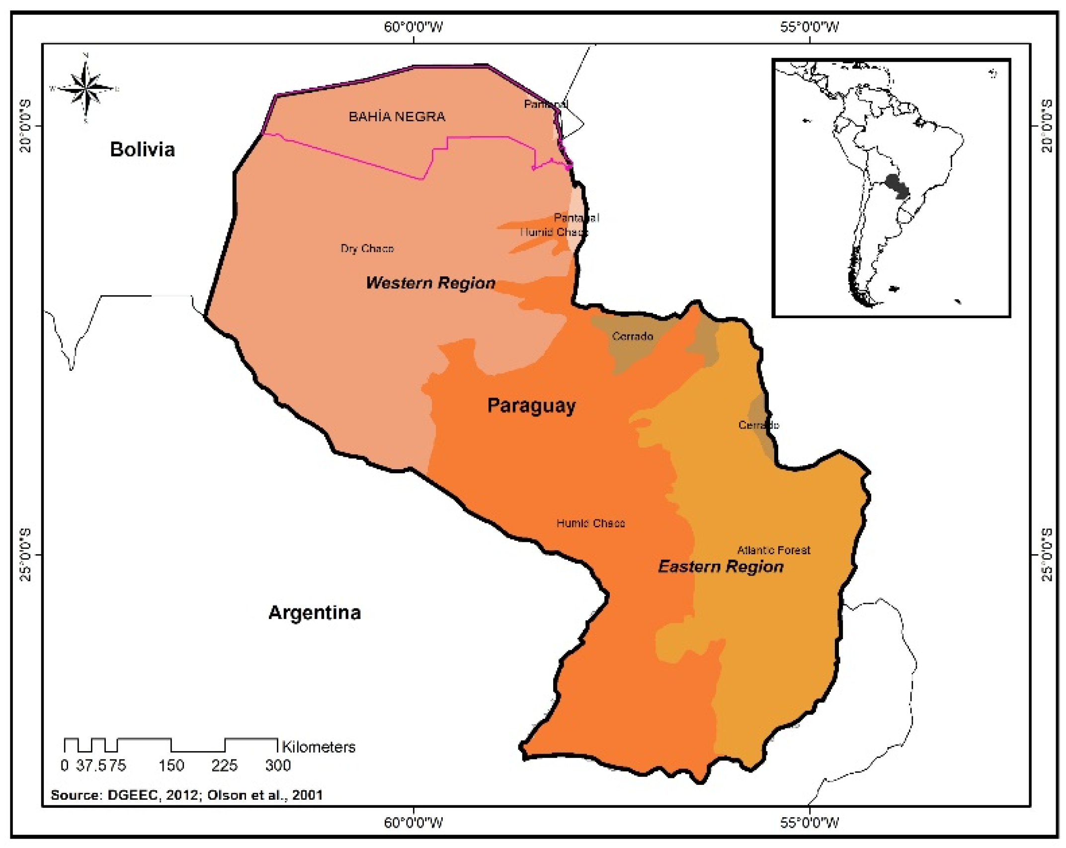
3.1. Study Site

Paraguay is located in the heart of South America, neighboring Argentina, Bolivia, and Brazil (Figure 1). Its population in 2012 was estimated at 6.4 million in an area of 406,752 km2 [48]. The Paraguay river divides the country into two regions, the Eastern region which has a humid subtropical/tropical climate, and the Western region which has a drier climate with less rainfall [40]. Paraguay is very rich in biodiversity and comprises six ecoregions which include the Pantanal, Dry Chaco, Medanos (part of Dry Chaco), Humid Chaco, Atlantic Forest, and Cerrado [49,50].
Paraguay is classified as a developing country [51], and in the last few years, has experienced economic growth above the regional average. However, this growth was at the expense of the country’s natural capital [39]. The main economic activities include agriculture and livestock production. Paraguay has one of the highest deforestation rates in the world (among the top 11 countries) [39], and most of this deforestation occurred in the Western region of the country (Chaco) [52]. The deforestation caused changes in ecosystem services, habitat destruction and fragmentation, and biodiversity loss [53,54]. It also affected indigenous communities which are at risk given their livelihood dependence on forests [55].
As such, Paraguay is a good case study for this research as it has many land-use conflicts (e.g., nature conservation and livestock production), high deforestation pressure, limited data on social-environmental systems, and a great diversity of stakeholders. Paraguay still has many gaps of information in several areas to conduct research e.g., [56]. Additionally, environmental problems are the result of poor enforcement of environmental laws and lack of land-use plans [40]. This country has low production costs for agriculture and livestock when compared to other countries from the region. Low production costs are considered an advantage, but at the same time, increase the risk of over-exploiting natural resources [39]. Potential solutions may include strategies to balance conservation and development. In recent years, many policies, including land-use planning, have been developed in the country under the leadership of the Secretariat of Technical Planning and Economic and Social Development (STP) [45].

3.2. Survey Design, Implementation and Analysis

We designed a survey to determine the feasibility of developing integrated land-use planning tools and the viability of acquiring the required data in the context of Paraguay as a developing country (Supplementary Materials). We conducted the survey to explore challenges, including data access and availability, to broaden the development of these plans. We extracted the most required data needs for land-use plans models from previous studies and used this information to create our own data list. We used this list to ask experts about their perspectives on the feasibility to collect these data. For this research, we defined an expert as someone with comprehensive knowledge in a specific area (e.g., environmental, social, and economic) and work experience in the country for more than a year. We then developed and implemented an online survey, using Qualtrics, a cloud-based platform following standard guidelines for designing and implementing web questionnaires [57]. The survey was conducted in Spanish. We refined the survey instrument through a pre-test with 15 survey design experts and other respondents to evaluate comprehension of the questions [57]. We recruited potential participants using a combination of a pre-established professional network as two of the authors previously worked in the country, and a snowball sampling method [58,59]. We contacted 15 experts in the first round and asked each respondent to provide at least three names of experts who could complete the survey. We stopped adding experts when the same people already surveyed were mentioned several times, which means that our sample was exhausted [58]. Seeking representation from different sectors, we targeted experts who work in academia, government institutions, non-governmental organizations and environmental associations, independent consultants, and private companies. A total of 27 experts from Paraguay completed the survey during November–December of 2019. The University of Arizona (UA) Institutional Review Board (IRB) reviewed and approved this study to ensure the protection of human research subjects.
We defined five categories to determine the level of difficulty in collecting data for land-use plans: very easy, moderately easy, neither easy nor difficult, moderately difficult, and very difficult. We included a description for each of the categories to ensure all respondents used the same criteria. We grouped the specific data needs identified in previous studies for the three dimensions and provided definitions and examples for each to improve their understanding (Table 2) [57]. Experts also had the option of writing in other data needs for each dimension. Additionally, participants ranked data from the most to the least important for developing land-use plans in Paraguay following the method proposed by Darvill and Lindo [60].
In the first section of the survey, participants responded to questions to determine how familiar they were with the concept of integrated land-use planning. We also asked about the difficulty in developing this type of land-use planning tool in Paraguay and the primary limitations that exist based on a pre-determined list extracted from existing literature and previous knowledge of the region. The respondents also had an option to add other limitations that they considered important. Then, experts identified their area of expertise choosing environmental, social, and economic based on their relevant experiences. The respondents only completed those sections that reflected their expertise. In the last section, the survey collected information on the demographics and professional backgrounds of the respondents. The results of the survey were analyzed using qualitative analysis for open questions, and quantitative analysis for closed-ended questions [60,61].

4. Results

4.1. Participants’ Profile

The survey was conducted in Paraguay. We reached 38 experts at the beginning; however, our final sample consisted of 27 experts (71.05% response rate) on environmental, social, and economic topics. Of these, 93% answered questions on environmental topics, 52% on social, and 30% on economic. Most of the survey respondents self-identified as female (61%), male (39%), and none of them as other genders. Of our respondents, 37% held a master’s degree and 70% of them had more than 7 years of working experience in Paraguay. Of our respondents, 48% worked in the non-governmental organization (NGO) sector, 22% in academia and research, 15% in government institutions, 4% in private companies, and 11% were independent consultants.

4.2. Integrated Land-Use Plans in Paraguay: Challenges and Opportunities

We asked experts if Paraguay has integrated land-use planning processes, and the majority responded affirmatively to this question. Most of them (73%) mentioned the land-use planning process conducted in the Municipality of Bahia Negra (Western Region) in 2016 as an example of integrated models. According to the experts, this plan was not yet fully approved as of December 2019. One expert highlighted that this process might need to include some additional information such as maps to assess ancestral territories and high-value conservation areas. When we asked how difficult it might be to develop these integrated plans in Paraguay, the overwhelming consensus among respondents was that developing these plans was difficult; 71% thought that it would be moderately difficult and an additional 21% thought it would be very difficult (Figure 2). However, a strong agreement was expressed by experts regarding the importance of these plans, 93% of the respondents agreed that Paraguay would benefit from having integrated land-use plans.

4.2.1. Challenges for Land-Use Planning in Paraguay

Our questionnaire asked respondents to select from four main barriers to developing integrated land-use plans in Paraguay. Lack of data was cited by 70%; 63% cited lack of resources to collect data; over half (53%) cited lack of expertise in collecting data, and approximately 50% of respondents thought that lack of interest in developing integrated land-use plans was a contributing factor. Of the 10 respondents who wrote in additional challenges, 2 identified the difficulty of engaging stakeholders in the process and the capacity to reach consensus among them. The quality of the existing data was also identified as a challenge. More specifically, different institutions produce geographic data for specific regions; however, there was little data consistency and these different data sets did not overlap geographically. Therefore, meta-data to ensure accuracy were limited, making their use for geographical analysis problematic. One person also noted that the cost to generate data was extremely high and financial resources were not available. Other challenges mentioned were the lack of political will, lack of coordination or cooperative work among institutions, and the absence of data/information sharing among institutions as there was a lack of central repository for all the data generated. Other respondents mentioned that several planning initiatives were funded by non-governmental institutions which posed a risk to the sustainability of these processes, in terms of continuation beyond the project. One respondent mentioned that the development of land-use plans depended exclusively on the political will of the authorities and if they did not consider it a priority, it would not be included in the budget. Another respondent mentioned that, in general, land-use planning processes were not participatory and local governments were not included.
Experts identified lack of data as the most important barrier to develop land-use plans in Paraguay. Therefore, we used the survey instrument to identify how difficult it was to collect environmental, social, and economic data in Paraguay to fill these gaps. We had five specific data needs for the environmental dimension, including ecosystem services, land-use/cover, biodiversity, habitat preference for species, and existing environmental policies. Based on the results, habitat preference were the most difficult data to collect; 28% of the respondents indicated this response, and the easiest was land-use/cover with 16% of respondents identifying this as easy (Figure 3a). Some respondents expanded the list provided in the survey and identified more data needed, including protected area boundaries, agroecological zones, biological corridors, and studies on fauna and flora.
We asked the participants to determine how important it was to obtain this data in case prioritization was needed. Participants ranked each data from most to least important. Experts determined that land-use/cover was the most important environmental data in a land-use planning model with 40% (Figure 4a). Habitat preference for species was never listed as number 1 (most important) or 2 by the respondents; however, it was listed as number 3 (16%), number 4 (36%), and number 5 (48%).
The social dimension included the following three criteria: social impact assessments, social land values, and stakeholder’s land-use preference. Experts identified that the most difficult social data to collect in Paraguay was the social impact assessment with 36% of the responses. The respondents also mentioned that social land values are moderately difficult to get with 57% of the responses. However, they indicated that land-use preference was neither easy nor difficult to collect (Figure 3b). When asked to add additional data needs to the list, some experts emphasized the difficulty of having or accessing social data in the country based on the list provided in the survey. One respondent also stated that there are few publications in the country, so it can be assumed that data systemization is minimal. Another respondent also mentioned that these data are moderately expensive to collect. Experts ranked social impact assessment as the most important data needed to include in an integrated land-use planning process with 36% of the responses. However, the social impact assessment was also identified as the least important with 36%. Another least important factor listed was land-use preference with 36% (Figure 4b).
For the economic dimension, we asked experts about the difficulty and importance of the economic value of ecosystem services, cost of conservation actions, opportunity costs, market land values, marginal value, or willingness to pay to access an additional unit of a service, economic return, and existing economic policies. The results showed that the economic value of ecosystem services was very difficult to estimate with 29% of the responses. Moreover, responses indicated that costs of conservation actions and existing economic policies were moderately difficult to collect with 25% for both. None of the data were identified as very easy to collect and market land values were defined as moderately easy with 63% (Figure 3c). One respondent wanted to emphasize that academia has made some progress towards data on the economic valuation of ecosystem services; but it might be necessary to work on the legal framework and include the concept of natural capital in planning activities.
Experts ranked existing economic policies as the most important data needed to develop an integrated land-use plan (50%). Existing policies include those related to the economic development of a specific region. Moreover, they identified market land value as the second most important with 50% (Figure 4c). Only existing economic policies, economic return, and economic value of ecosystem services were listed as most important. Opportunity costs, market land values, and economic value of ecosystem services were never listed as least important (selected as number 7).

4.2.2. Opportunities for Integrated Land-Use Planning in Paraguay

There are challenges for Paraguay in developing land-use plans, but there are also many potential opportunities with using an integrated model. As previously mentioned, most of the survey respondents (93%) agreed that Paraguay would benefit from having an integrated land-use planning model. The survey respondents mentioned many opportunities or advantages including the proposition that land-use planning could facilitate more organized urban and rural development in the country by balancing the available natural resources and their sustainable use. Moreover, a theme among responses was that an integrated model can support the effective allocation of forest reserves and biological corridors and prioritize conservation activities and ecosystem services. One respondent also mentioned that the land-use plan would allow a more balanced development that would safeguard resources for future generations, especially considering the need for new scenarios resulting from climate change. Additionally, this respondent mentioned that with proper planning there would be no issues of water availability in certain parts of the country; otherwise, considerable conflicts could arise between the different sectors (e.g., agriculture, population in general). This respondent also added that it is known that some cities will grow in Paraguay, and therefore it would be better to engage in planning to prepare for this growth.
One expert sees land-use planning as a legal tool to manage the territory, promote decentralization of public functions if local governments are included, and improve law enforcement. Additionally, this respondent mentioned that land-use plans can guide investments, as it might provide information on the best location for different land-use options to reduce environmental and social risks. Another opportunity is that the model could help to standardize the land-use planning process in all the municipalities of Paraguay. Moreover, this model could ensure inter-institutional data sharing to lay the foundations for the development of a national database. The respondents also highlighted some important advances in the country regarding more participatory land-use planning processes (i.e., the Municipality of Bahia Negra), and the publication of guidelines to develop land-use planning e.g., [45].

5. Discussion

Many governments worldwide have committed to develop in a more sustainable way; however, global tendencies are still far from achieving sustainability. Land-use planning arose as a strategy to achieve sustainability, but many challenges still remain to develop and implement these plans across the Global South. This paper explored the feasibility of developing integrated land-use planning by engaging with experts, planners and implementers thorough a survey built on criteria in the literature and implemented in Paraguay. Most experts mentioned that Paraguay will benefit from having integrated land-use plans to promote sustainable development, among other aspects. This finding aligns with previous studies in China, Spain, and Tanzania among others, stating that land-use planning might play a key role in achieving sustainable development goals [8,9,10,11,12,15]. Yet to achieve this, land-use plans need to integrate the environmental, social and economic dimensions of sustainability during the process [12]. Several studies have highlighted the importance of integrating all three dimensions into one model [27,62,63,64]. However, political will and institutional challenges also play relevant roles and can compromise the success of these policies, especially in developing countries [24]. Experts expressed some of the advantages of having land-use plans which correspond to studies in West Africa and Paraguay that discussed the identification of synergies and trade-offs among the different dimensions in complex landscapes to find a balance between conservation and development [23,56]. An integrated approach might determine the right allocation for different land-use options and anticipate and minimize potential conflicts [27,65].

5.1. Challenges to Develop Integrated Land-Use Plans
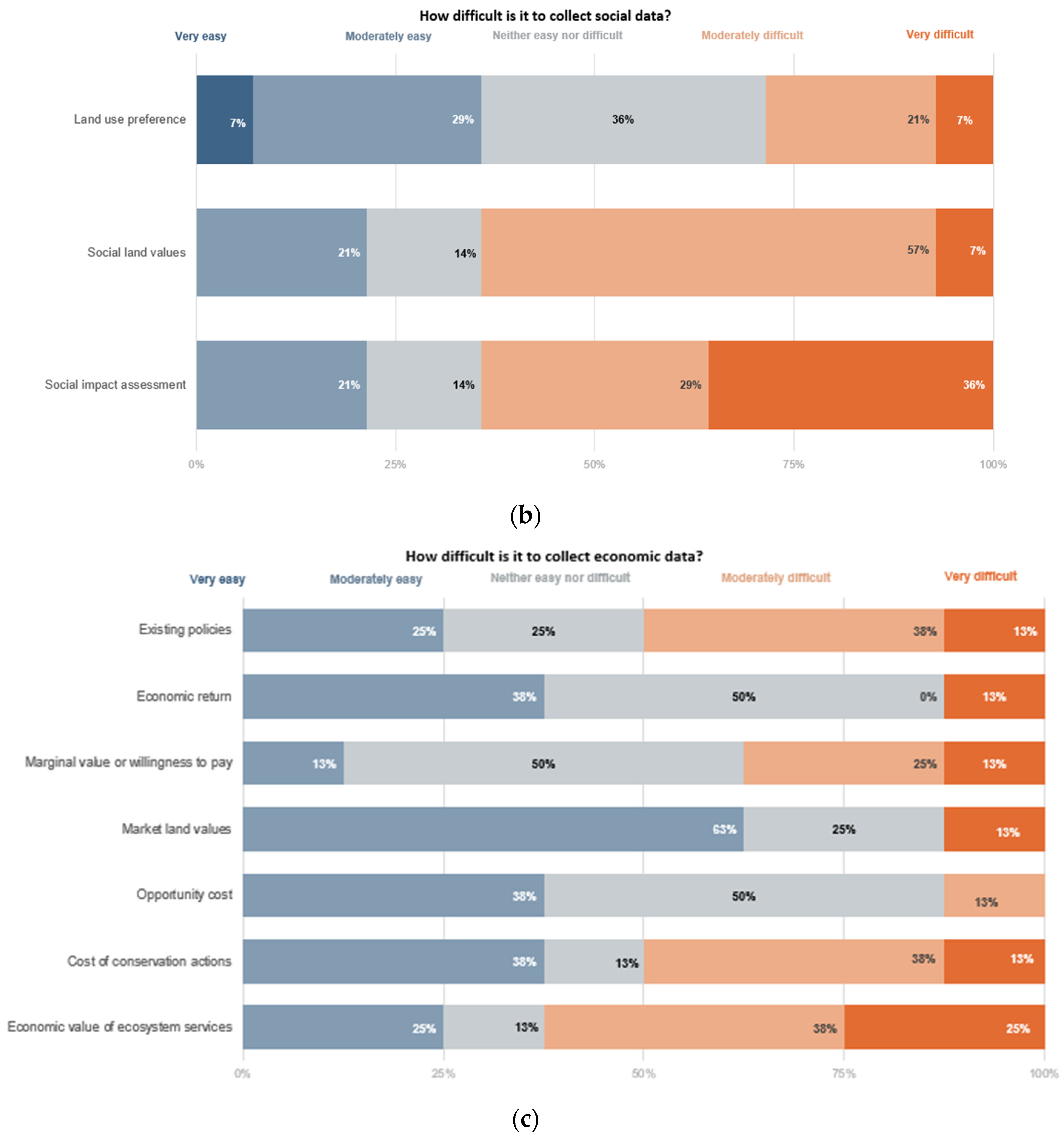
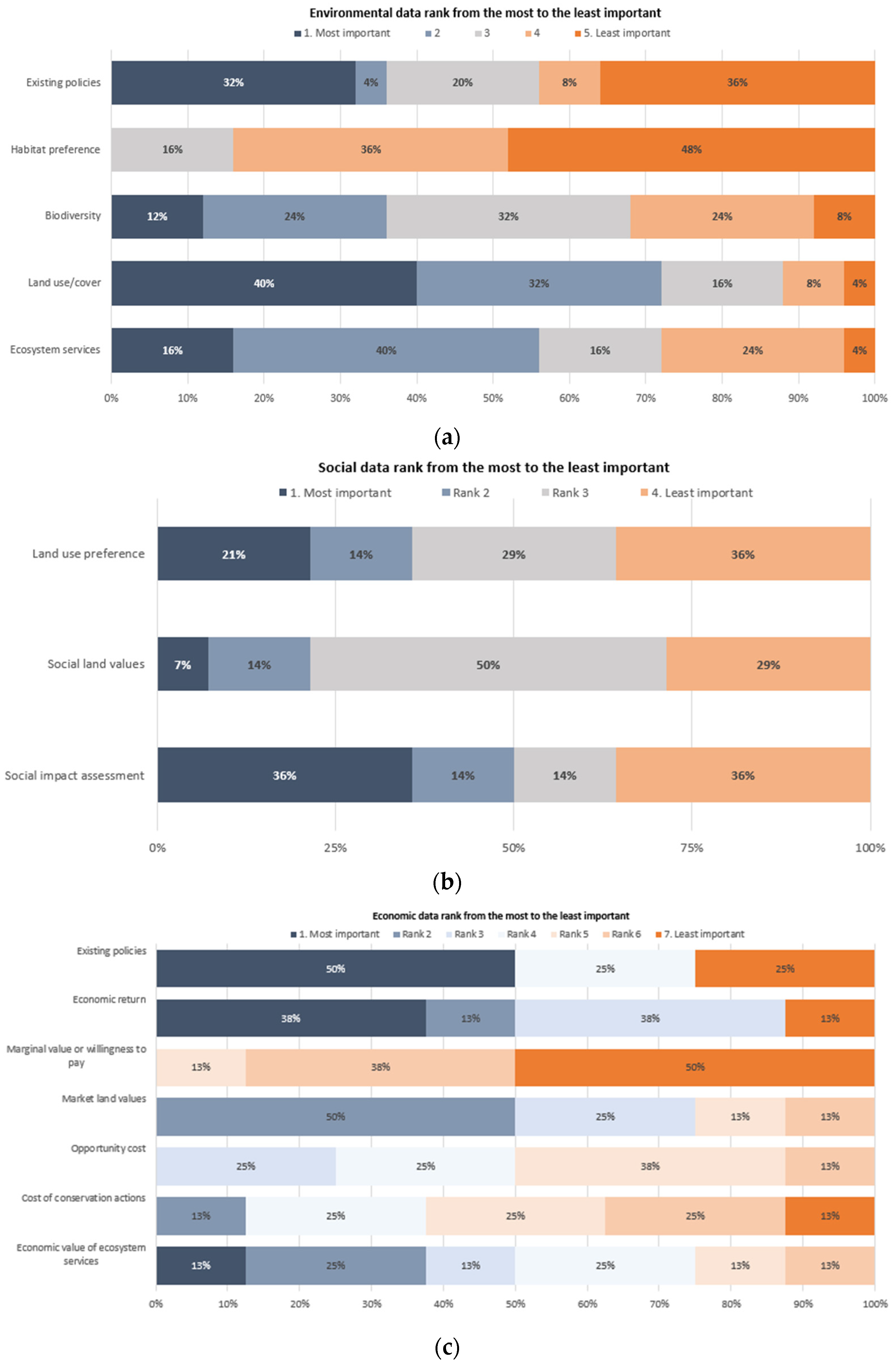
According to our results, land-use planning processes face challenges that affect their broader application in Paraguay, as in many other developed and developing countries e.g., [18,31,66]. These challenges need to be identified and addressed to move forward with implementing land-use plans. Our results highlighted some of the existing obstacles or challenges to fully develop and implement land-use plans in Paraguay, and these might be used in other developing countries with a similar context, such as Argentina and Bolivia, which share the Gran Chaco region with Paraguay [30,67,68]. Several challenges were identified by our experts, and we focused our discussion on the lack of data, political will, stakeholder engagement, and insufficient financial and human resources.

5.1.1. Lack of Data

Most of our respondents mentioned that lack of data was one of the main challenges in Paraguay. Choosing one model or another is influenced by the data required for them [31]. Given the complexity of land-use planning, most of the data needed and the models for integrated plans may be very difficult to obtain in developing countries of the Global South [18,41]. These challenges are also faced by Global North countries; however, Global South countries have fewer financial, technological, and human resources to overcome these challenges e.g., [69]. It has been shown that simpler models can be used in planning. For example, Von Bertrab et al. [70] described a six-step approach to developing plans that consider aspects related to both nature and development, including tradeoffs, opportunities, and potential risks that may exist between the two. This approach has been successfully implemented in Mexico, Jordan, Brazil, Cote D’Ivoire, and Colombia.
The participants also indicated that data validity is a problem, which corresponds with other studies that state that lack of relevant and valid data is an issue for land-use planning processes and for making informed decisions [71]. For example, Sallustio et al. [72] mentioned that Europe still lacks national harmonized datasets to classify marginal lands. We also find that there is lack of coordination or of joint work among institutions. Some authors also note that this lack of cooperation among local and regional data, efforts, and actions can cause delays in the processes [33,38,73]. The lack of data is an important issue for Paraguay and many other developing countries. Therefore, data collection and prioritization strategies would be recommended to fill the gaps. It is also important to identify existing studies that can support land-use planning processes in Paraguay [74], especially when the required data to develop integrated land-use planning is not easy to obtain. This is consistent with the results of a study by Naidoo and Rickets [56], who conducted a spatial cost-benefit analysis for conservation planning and found that the availability of relevant data was limited for their study region in Paraguay. Another study in Paraguay mapped multiple benefits of REDD+ to support land-use planning and faced challenges due to the lack of available information on the forest conditions and location of degraded forests in the country [74]. A study in Africa stated that data limitation was an issue when using some land-use planning models and that some data had to be dropped because of this [11]. To address this challenge, we also need to better understand why data are so difficult to collect. Here, we discuss some of the most difficult data to collect and provide some potential solutions.
More specifically, our survey results show that most respondents identified land-use/cover maps as important for land-use planning, and as the easiest to collect. Land-use/cover maps play an important role in understanding land dynamics for implementing a multifunctional landscape planning approach [75,76]. Satellite remote-sensing data can provide consistent land-use/cover maps with investment in data acquisition, processing, and analysis [52]. Regarding habitat preference for species, a high percentage of responses consider these data very difficult to collect due to the complexity of these data, the need to have them for each species of interest, and the pattern of land-use, species-habitat associations, and species range [77]. These data might not be available in some regions; our respondents also identified these data as the least important.
Respondents stated that it is very difficult to collect social impact assessment data, which require the identification and analysis of land-use conflicts among stakeholders that are usually carried out using stakeholder consultation methods [37,78]. It might be difficult to collect these data because conflicts are very sensitive and land conflicts played a significant role in the history of Paraguayan economic development, social stratification, and international relations [79]. We assume that this may limit the collection of these data in the country. In general, most conflicts involve disagreements over values and objectives, as well as power differences, and issues about property rights [36]. However, as social impact assessment was also referred to as the most important issue (36%), specific methods need to be developed to generate this information despite the challenges, or a similar indicator might still need to be identified to account for this social dimension. For example, one study from Tanzania assessed land-use conflicts and used a participatory analysis to identify land users and social groups [18]. Social impact assessment was also identified as the least important data (36%), indicating that the experts’ opinions were polarized, and this might be the result of different approaches or methods used to conduct this assessment.
Regarding the economic dimension, the most difficult data to collect are the values of ecosystem services. The ecosystem services approach in Latin America is still difficult to implement into governance. Involving multiple and diverse stakeholders with power differences and contrasting interests makes incorporation of this approach particularly challenging [80]. The concept still creates confusion and there is a lack of knowledge on how to connect it with planning and policy [81,82]. In addition, the ecosystem services approach requires testing and validation, which is not yet well described [81]. In some cases, ecosystem services can be undervalued, as discussed in a study case conducted in Hungary [83]. Another study conducted in the United States mentioned that there is much uncertainty about ecosystem service values that make it difficult for integration [84]. However, some scholars have focused their efforts on trying to make the concept more usable for decision making by offering frameworks to connect ecosystem services and land-use planning policies [82,85], as well as lessons from previous experiences including more iterative science-policy process and empowerment of experts with technical tools that can help them in gathering and analyzing data [86]. Experts identified existing economic policies as the most important information to take into account. Pourebrahim et al. [64] used data from existing policies (e.g., the National Ecotourism Plan for Malaysia) to set the objectives for the development of the region, which is essential before initiating any land-use planning processes. Attention to these policies can determine which land uses might need to be prioritized, taking into consideration the sustainable development of the region.
Lack of data might not necessarily be a limitation for decision makers or planners to develop land-use plans and make decisions [71]. Some studies have navigated the lack of data by integrating local stakeholders into participatory land-use planning processes which can have a dual benefit, such as gathering the required information and promoting more transparent decision making [16,18]. This engagement can empower local stakeholders/communities to make their voices heard and facilitate the process of building trust and sharing knowledge which will benefit the implementation of land-use planning [87]. Another study in Paraguay used different data/indicators to fill in gaps of information [74]. This paper presents several examples that could be adapted to different contexts to overcome some of the existing challenges.

5.1.2. Lack of Political Will

Our respondents stated that political will was a key challenge to moving forward with the development and implementation of land-use plans. The lack of political support was a major threat to planning processes [23], and this was beyond the scope of scientists [22,23]. The will to develop land-use planning would need to come from the government and several issues needed to be addressed [88]. Some studies have shown how land-use planning benefits when government authorities are engaged by providing access to data and/or participating as key stakeholders in workshops or interviews [16,29,89]. Conflicting interests and policies among institutions are issues that can slow down the development of land-use plans [31]. For example, the land-use planning process might be led by certain political interests that might differ on what is appropriate for the land and stakeholders [28,29,90,91]. A study conducted in China mentioned that the government wanted to invest more funds in one region to develop the economy there over other regions [92]. In a study in Peru, planners were not granted access to data to develop ecological and economic zoning, as the government had previously made the decision to promote mining activities in the region. This demonstrates how contrasting political positions can influence future land and water use [34]. Additionally, some governments still lack or can improve the required regulations or legal frameworks to develop and implement land-use planning processes [4,33,38]. These regulations or models might exist, but they are not very accessible to decision makers which can make their application difficult [93]. For example, land-use planning models are often developed in an academic setting, and to implement them in the real world with public agencies can be challenging [31]. According to Sili and Avila [40], Paraguay needs to redefine its own policies and practices for land-use planning to ensure improvement of planning models, capacity development at the level of technical and political institutions, and the effective implementation of legal frameworks.

5.1.3. Stakeholders’ Engagement and Insufficient Financial and Human Resources

Some respondents also referred to other challenges, including stakeholder engagement and financial and human resources availability. When land-use plans do not use participatory approaches and local governments are not included, there is a risk of developing top-down plans. This situation might lead to land-use plans that are developed by practitioners who do not fully understand the context of the region. Even if the land-use plan meets all the requirements and has the best data and analysis, if the outcome is not practical for local stakeholders, the plan will not be implemented in the field [24]. The involvement of local people is crucial since they know the dynamics of the region [94]. This is even more important in data-scarce regions, where local stakeholders could be part of participatory data and knowledge collection that can help fill existing gaps and enable more relevant decision-making [95]. However, engaging stakeholders in these processes can be challenging in Paraguay and other countries, as many of our respondents mentioned. Therefore, alternative ways to promote participation might be needed, such as assisted workshops instead of self-administered surveys e.g., [23,31]. A study conducted in Spain stated that including public participation in planning is difficult so they designed a strategy to ensure participation in every stage of the planning process [20]. The conservation strategy of the Lao People’s Democratic Republic combines land-use planning with information on the needs of local communities living around or within protected areas to improve their livelihoods. This has increased communities’ desire to participate in the process, as one of the main outcomes was that their land tenure would be officially recognized [96]. Additionally, land-use planning processes may benefit from promoting participation of indigenous people. In Paraguay, they account for 130,000 inhabitants (approx. 2% of the total population) [97]. Indigenous lands were not listed by the respondents as required data for an integrated land-use planning, but we wanted nevertheless to highlight the importance of considering this information as part of the process. A study carried out in the Chaco region of Argentina presents an example of how to include areas claimed by indigenous communities as one layer of information in land-use planning processes. This study categorized indigenous areas with high conservation values; however, they also emphasized the challenges in operationalizing the maps produced, as this requires political will. They mentioned that the government only accepted to identify those areas with medium conservation value, despite the communities wanting to categorize them with a higher value. The indigenous communities requested to take care of their own lands to ensure the integrity of nature and culture in their territories; however, according to the study, the re-categorization of those lands was not granted [71]. Another example was the land-use plan of the Bahia Negra municipality in Paraguay, where consultations were done with communities to identify indigenous lands. During the process, these communities identified some ancestral lands that they are claiming and as a result of the process, these lands are now included in the draft of the map.
We also found that lack of resources to generate data is a critical barrier. Developing countries often have limited financial resources and technical capacity to develop and implement land-use planning processes at the local/district level. For example in Tanzania the 1999 Land-use Planning Act has been implemented in only 13% of the villages as of 2019, largely due to dependence on funding from international organizations and some other land issues that exist in the village including illegal land transactions and tenure insecurity [18]. In Ghana, national and international NGOs (e.g., Korea International Cooperation Agency, KOICA) as well as the business community (e.g., Tullow Oil) conduct land-use planning processes and influence land-use priorities [33]. However, there are some strategies to navigate these challenges. A previous study conducted in Paraguay identified some potential solutions to secure funds for these processes, some of them included the use of the countries’ royalties and/or support from cooperative agencies and public-private alliances [40]. Additionally, local experts can be trained to lead data collection and analysis [86].

5.2. Opportunities for Integrated Land-Use Planning in Paraguay

In addition to the identified challenges, there are also many opportunities with using an integrated model. This model proposes a bottom-up strategy with stakeholders playing an important and active role in decision-making processes, which can result in fewer social conflicts over land-use [25]. Fewer conflicts can lead to effective plan implementation in the long-term [7]. Our respondents also highlighted the difficulty to reach consensus; and some previous studies used tools to manage power differences among stakeholders such as empowerment and participatory exercises [36,98]. It may be that those stakeholder groups with more power can promote decisions that are only favorable to their interests [99]. Experts see land-use planning as a legal instrument to promote decentralization of public functions and enforcement; however, this would require a shift in political strategies and agenda to empower local governments [100]. This means securing financial resources and strengthening capacities of local governments [40]. Austin [94] stated that the rationale behind decentralization is that local stakeholders are the ones with knowledge about their needs, challenges and potential solutions, so they need to be actively involved in these conversations.
Our experts also referred to land-use planning as a key tool to address water availability issues in Paraguay. It is well known that land-cover changes affect ecosystem functioning and hydrological cycles [101,102,103,104]. As mentioned earlier, Paraguay experiences high deforestation rates, and this is a challenge as forests are essential for the hydrological cycle and water supply, and also to regulate atmospheric moisture fluxes and precipitation patterns over terrestrial areas [102]. Land-use planning can integrate water ecosystem services to ensure provision in the long term [105]. This integrative vision in planning allows identifying the effects and consequences of the hydrological cycle in relation to the ecosystems of the region [102]. A case study conducted in Germany explored the role of land-use planning to address water issues. They found that there are many benefits for water quality and biodiversity when water is included in development plans. However, they also acknowledge the challenges in doing so, and they recommend raising awareness among stakeholders and decision makers about the multiple benefits of including water aspects [106]. Another study conducted in the Paraguayan Chaco highlighted the benefits of conserving forest belts around lagoons to reduce vulnerability to salinization, keeping the salty water table at a safe distance from the surface [107]. This recommendation is accepted as a land-use planning component for this region [107], ensuring long-term provision of water ecosystem services in this semi-arid region. Moreover, Carter et al. [106] presented a case study to identify water-forest protective belts in Latvia. With this study, they proved that the inclusion of water issues in planning can reduce negative impacts on water pollution, reduce erosion, limit development to reduce flooding events, and protect local landscapes. Paraguay can benefit from these examples, as land-use planning is at its beginning. The country already has in place legislation that connects to land-use planning: (1) the Decree Number 9824 of the Law number 4241 of 2010 of re-establishment of forest belts of water courses, and (2) the Law number 3239 of 2007 of water management regulation. Private landowners and companies need to comply with these two laws that are part of the land-use plans that are required at the property level (Table 1). This legislation is to be included as part of the land-use planning process in the country. This might be built on existing legislation or policies to speed up the development and implementation of plans.
The use of land-use planning as a legal tool also needs some discussion. As mentioned before, Paraguay requires each municipality to have an urban and territorial land-use plan, which is supported by the municipal organic letter (Law 3966 of 2010). However, there are still many challenges to fully enforce its compliance due to the lack of political will and insufficient financial and human resources. Currently, the government has made progress by creating a national law project on land-use planning to define the principles, criteria, and rules to ensure sustainable land-use planning. This new legislation will define the different land zones suitable for agriculture and livestock, forestry, mining, and industrial activities. Additionally, it will determine which areas should be conserved and protected, it will delimit indigenous lands, and areas suitable for urban development [46]. To date, land-use planning cannot be used as a legal tool, but that does not mean that it cannot be used in the near future.

6. Conclusions

Using Paraguay as an example, this study explores the feasibility of developing integrated land-use plans in developing countries where there are challenges to their adoption including data availability and collection, financial and human resources, and political will. We assessed the challenges and opportunities by conducting a survey of experts from Paraguay. We highlighted the existing alternatives to navigate these challenges using examples from other countries. Developing and developed countries can face similar challenges in terms of data availability and quality, especially for ecosystem services and marginal land values. Developing countries are still at a disadvantage because the priorities of each country are defined according to different contexts, which in most cases includes the situation of poverty that is experienced in the South. Thus, differences also occur in terms of financial, technological, and human resources. If we acknowledge these challenges, we can develop solutions and improve the land-use planning process. The integration of the three dimensions of sustainability might help reduce land-use conflicts and ensure that all interests are taken into consideration, which is crucial for complex landscapes. If integrated plans are to be used in diverse contexts, it will be necessary to develop this integrated vision to apply in different contexts, even in places where not much data are available. Furthermore, it might be required to ensure that land-use plans are not only developed on “paper” but implemented in the field so they can meet their goals.
Our study has some practical implications. Development and implementation of land-use plans in a developing country context may require the cooperation of public entities, regional governments, and NGOs to work in concert. Our study, and the land-use planning literature generally, suggests several challenges that require consideration when applying land-use plans in Paraguay and other developing country contexts. For example, the lack of data suggests that simpler and more participatory models with bottom-up approaches that increase stakeholders’ engagement and facilitate the consensus over land-uses may serve to increase the feasibility of implementing land-use plans in Paraguay and similar countries. The six-step approach proposed by Von Bertrab et al. [70] might be an alternative for developing a simple land-use planning model for a country such as Paraguay. Simpler models might still fulfill their role without sacrificing quality and validity. Additionally, it may be beneficial to centralize efforts to gather and store data and information from different institutions. The availability of a coordinated or centralized location for data may facilitate prioritizing data collection in key areas that would help to broaden the application of existing land-use planning models. Lastly, institutional support and political will are important elements for the successful implementation of land-use plans. Buy-in from decision makers helps address most of the land-use planning challenges, especially that of securing financial resources for their development. As the land-use planning framework happens at national, governmental, municipal, and property levels, aligning these tools may help to promote the same goal. These are more effective when land-use plans are being rolled out in the country. Acknowledging challenges; developing strategies to navigate these challenges; and creating a sound legal framework for land-use plans may be helpful. As we described earlier, having the enabling conditions in place might be challenging for certain regions; however, the existence of policy instruments may help to implement plans in the field successfully.
This study might serve as a stepping-stone towards a broader application of integrated land-use plans in Paraguay and other countries with similar challenges. In addition, further research might assess the effectiveness of the land-use plans to achieve sustainability and respecting the environmental, social, and economic dimensions of land-use planning.

Supplementary Materials

The following are available online at https://www.mdpi.com/article/10.3390/land11081339/s1, Survey S1: Desarrollo de un plan de ordenamiento territorial multidimensional en Paraguay.

Author Contributions

Conceptualization, S.D., K.A.S. and K.M.; Formal analysis, S.D.; Investigation, S.D.; Methodology, S.D., K.A.S., S.T. and J.R.S.; Writing—original draft, S.D.; Writing—review and editing, K.A.S., S.T., K.M., S.E.M. and J.R.S. All authors have read and agreed to the published version of the manuscript.

Funding

This research received no external funding.

Institutional Review Board Statement

The study was conducted in accordance with the Declaration of Helsinki, and approved by the Institutional Review Board of the University of Arizona (protocol code 1908859048 from 5 September 2019).

Informed Consent Statement

Informed consent was obtained from all subjects involved in the study.

Data Availability Statement

The data supporting reported results can be made available upon request.

Acknowledgments

The authors thank the experts who completed the survey, and colleagues who reviewed this paper.

Conflicts of Interest

The authors declare no conflict of interest.

Disclaimer

This research was supported in part by the US Department of Agriculture, Economic Research Service. The findings and conclusions in this publication are those of the authors and should not be construed to represent any official U.S. Department of Agriculture or U.S. Government determination or policy.

References

  1. Winkler, K.; Fuchs, R.; Rounsevell, M.; Herold, M. Global land use changes are four times greater than previously estimated. Nat. Commun. 2021, 12, 2501. [Google Scholar] [CrossRef] [PubMed]
  2. Mahmoud, S.H.; Gan, T.Y. Impact of anthropogenic climate change and human activities on environment and ecosystem services in arid regions. Sci. Total Environ. 2018, 633, 1329–1344. [Google Scholar] [CrossRef] [PubMed]
  3. Foley, J.A.; DeFries, R.; Asner, G.P.; Barford, C.; Bonan, G.; Carpenter, S.R.; Chapin, F.S.; Coe, M.T.; Daily, G.C.; Gibbs, H.K.; et al. Global consequences of land use. Science 2005, 309, 570–574. [Google Scholar] [CrossRef] [PubMed]
  4. Popescu, O.-C.; Tache, A.-V.; Petrișor, A.-I. Methodology for identifying ecological corridors: A spatial planning perspective. Land 2022, 11, 1013. [Google Scholar] [CrossRef]
  5. FAO. Guidelines for Land Use Planning; Soil Resources, Management and Conservation Service under the Guidance of the Inter-Departmental Working Group on Land Use Planning; Food and Agriculture Organization of the United Nations: Rome, Italy, 1993; ISBN 92-5-103282-3. [Google Scholar]
  6. Turkelboom, F.; Leone, M.; Jacobs, S.; Kelemen, E.; García-Llorente, M.; Baró, F.; Termansen, M.; Barton, D.N.; Berry, P.; Stange, E.; et al. When we cannot have it all: Ecosystem services trade-offs in the context of spatial planning. Ecosyst. Serv. 2018, 29, 566–578. [Google Scholar] [CrossRef]
  7. Metternicht, G. Land Use and Spatial Planning: Enabling Sustainable Management of Land Resources; Springer Nature: Cham, Switzerland, 2018; ISBN 978-3-319-71860-6. [Google Scholar]
  8. Palacios-Agundez, I.; Fernández de Manuel, B.; Rodríguez-Loinaz, G.; Peña, L.; Ametzaga-Arregi, I.; Alday, J.G.; Casado-Arzuaga, I.; Madariaga, I.; Arana, X.; Onaindia, M. Integrating stakeholders’ demands and scientific knowledge on ecosystem services in landscape planning. Landsc. Ecol. 2014, 29, 1423–1433. [Google Scholar] [CrossRef]
  9. Zhou, M. An interval fuzzy chance-constrained programming model for sustainable urban land-use planning and land use policy analysis. Land Use Policy 2015, 42, 479–491. [Google Scholar] [CrossRef]
  10. Li, Q.; Yu, Y.; Jiang, X.; Guan, Y. Multifactor-based environmental risk assessment for sustainable land-use planning in Shenzhen, China. Sci. Total Environ. 2019, 657, 1051–1063. [Google Scholar] [CrossRef]
  11. Lubida, A.; Veysipanah, M.; Pilesjo, P.; Mansourian, A. Land-use planning for sustainable urban development in Africa: A spatial and multi-objective optimization approach. Geod. Cartogr. 2019, 45, 1–15. [Google Scholar] [CrossRef]
  12. Rydin, Y. Sustainable Development and the Role of Land Use Planning. Area 1995, 27, 369–377. [Google Scholar] [CrossRef]
  13. Yañez Soria, K.; Ribeiro Palacios, M.; Morales Gomez, C.A. Governance and policy limitations for sustainable urban land planning. The case of Mexico. J. Environ. Manag. 2020, 259, 109575. [Google Scholar] [CrossRef]
  14. Adams, V.M.; Álvarez-Romero, J.G.; Capon, S.J.; Crowley, G.M.; Dale, A.P.; Kennard, M.J.; Douglas, M.M.; Pressey, R.L. Making time for space: The critical role of spatial planning in adapting natural resource management to climate change. Environ. Sci. Policy 2017, 74, 57–67. [Google Scholar] [CrossRef]
  15. Gobierno Nacional. Plan Nacional de Desarrollo Paraguay 2030; Gobierno Nacional del Paraguay: Asunción, Paraguay, 2014. [Google Scholar]
  16. Ioki, K.; Din, N.M.; Ludwig, R.; James, D.; Hue, S.W.; Johari, S.A.; Awang, R.A.; Anthony, R.; Phua, M.-H. Supporting forest conservation through community-based land use planning and participatory GIS–lessons from Crocker Range Park, Malaysian Borneo. J. Nat. Conserv. 2019, 52, 125740. [Google Scholar] [CrossRef]
  17. Enoguanbhor, E.C.; Gollnow, F.; Walker, B.B.; Nielsen, J.O.; Lakes, T. Key Challenges for Land Use Planning and Its Environmental Assessments in the Abuja City-Region, Nigeria. Land 2021, 10, 443. [Google Scholar] [CrossRef]
  18. Eilola, S.; Käyhkö, N.; Ferdinands, A.; Fagerholm, N. A bird’s eye view of my village–Developing participatory geospatial methodology for local level land use planning in the Southern Highlands of Tanzania. Landsc. Urban Plan. 2019, 190, 103596. [Google Scholar] [CrossRef]
  19. Karimi, A.; Adams, V.M. Planning for the future: Combining spatially-explicit public preferences with tenure policies to support land-use planning. Land Use Policy 2019, 82, 497–508. [Google Scholar] [CrossRef]
  20. Santé, I.; Fernández-Ríos, A.; Tubío, J.M.; García-Fernández, F.; Farkova, E.; Miranda, D. The Landscape Inventory of Galicia (NW Spain): GIS-web and public participation for landscape planning. Landsc. Res. 2019, 44, 212–240. [Google Scholar] [CrossRef]
  21. Kim, I.; Arnhold, S. Mapping environmental land use conflict potentials and ecosystem services in agricultural watersheds. Sci. Total Environ. 2018, 630, 827–838. [Google Scholar] [CrossRef]
  22. Albert, C.; Aronson, J.; Fürst, C.; Opdam, P. Integrating ecosystem services in landscape planning: Requirements, approaches, and impacts. Landsc. Ecol. 2014, 29, 1277–1285. [Google Scholar] [CrossRef]
  23. Inkoom, J.N.; Frank, S.; Fürst, C. Challenges and opportunities of ecosystem service integration into land use planning in West Africa–an implementation framework. Int. J. Biodivers. Sci. Ecosyst. Serv. Manag. 2017, 13, 67–81. [Google Scholar] [CrossRef]
  24. McNeill, D.; Bursztyn, M.; Novira, N.; Purushothaman, S.; Verburg, R.; Rodrigues-Filho, S. Taking account of governance: The challenge for land-use planning models. Land Use Policy 2014, 37, 6–13. [Google Scholar] [CrossRef]
  25. De Wit, P.; Verheye, W.H. Land use planning for sustainable development. In Land Use, Land Cover and Soil Sciences; UNESCO-EOLSS Publishers: Oxford, UK, 2007. [Google Scholar]
  26. Truong, Q.C.; Nguyen, T.H.; Tatsumi, K.; Pham, V.T.; Tri, V.P.D. A land-use change model to support land-use planning in the Mekong Delta (MEKOLUC). Land 2022, 11, 297. [Google Scholar] [CrossRef]
  27. de Groot, R.; Alkemade, R.; Braat, L.; Hein, L.; Willemen, L. Challenges in integrating the concept of ecosystem services and values in landscape planning, management and decision making. Ecol. Complex. 2010, 7, 260–272. [Google Scholar] [CrossRef]
  28. Jahantigh, H.R.; Masoudi, M.; Jokar, P. A quantitative approach to land use planning using GIS-A case study of chabahar county, Iran. Eur. J. Environ. Sci. 2019, 9, 12–20. [Google Scholar] [CrossRef]
  29. Derak, M.; Cortina, J.; Taiqui, L. Integration of stakeholder choices and multi-criteria analysis to support land use planning in semiarid areas. Land Use Policy 2017, 64, 414–428. [Google Scholar] [CrossRef]
  30. Recatalá Boix, L.; Zinck, J.A. Land-Use Planning in the Chaco Plain (Burruyacú, Argentina): Part 2: Generating a Consensus Plan to Mitigate Land-Use Conflicts and Minimize Land Degradation. Environ. Manag. 2008, 42, 200–209. [Google Scholar] [CrossRef]
  31. Waddell, P. Integrated land use and transportation planning and modelling: Addressing challenges in research and practice. Transp. Rev. 2011, 31, 209–229. [Google Scholar] [CrossRef]
  32. Kaswamila, A.L.; Songorwa, A.N. Participatory land-use planning and conservation in northern Tanzania rangelands. Afr. J. Ecol. 2009, 47, 128–134. [Google Scholar] [CrossRef]
  33. Kleemann, J.; Inkoom, J.N.; Thiel, M.; Shankar, S.; Lautenbach, S.; Fürst, C. Peri-urban land use pattern and its relation to land use planning in Ghana, West Africa. Landsc. Urban Plan. 2017, 165, 280–294. [Google Scholar] [CrossRef]
  34. Preciado Jeronimo, R.; Rap, E.; Vos, J. The politics of land use planning: Gold mining in Cajamarca, Peru. Land Use Policy 2015, 49, 104–117. [Google Scholar] [CrossRef]
  35. Fürst, C.; König, H.; Pietzsch, K.; Ende, H.-P.; Makeschin, F. Pimp your landscape-a generic approach for integrating regional stakeholder needs into land use planning. Ecol. Soc. 2010, 15, 34. [Google Scholar] [CrossRef]
  36. Brown, G.; Sanders, S.; Reed, P. Using public participatory mapping to inform general land use planning and zoning. Landsc. Urban Plan. 2018, 177, 64–74. [Google Scholar] [CrossRef]
  37. Bourgoin, J.; Castella, J.-C. “PLUP Fiction”: Landscape simulation for participatory land use planning in northern Lao PDR. Mt. Res. Dev. 2011, 31, 78–88. [Google Scholar] [CrossRef]
  38. Sumarga, E.; Hein, L. Mapping ecosystem services for land use planning, the case of Central Kalimantan. Environ. Manag. 2014, 54, 84–97. [Google Scholar] [CrossRef]
  39. World Bank. Paraguay-Systematic Country Diagnostic; World Bank: Washington, DC, USA, 2018; p. 130. [Google Scholar]
  40. Sili, M.; Avila, C. El lento proceso de construcción de la planificación territorial en Paraguay. Perspect. Rural Dev. 2019, 2018, 131–153. [Google Scholar] [CrossRef]
  41. Albert, C.; Galler, C.; Hermes, J.; Neuendorf, F.; Von Haaren, C.; Lovett, A. Applying ecosystem services indicators in landscape planning and management: The ES-in-Planning framework. Ecol. Indic. 2016, 61, 100–113. [Google Scholar] [CrossRef]
  42. Secretaría Técnica de Planificación. Plan Marco Nacional de Desarrollo y Ordenamiento Territorial; Secretaría Técnica de Planificación: Asunción, Paraguay, 2012. [Google Scholar]
  43. Servicio Forestal Nacional. Resolución No 224/2001-Por La Cual se Reglamenta La Elaboración y Presentación de Los Planes de Uso de La Tierra; Leyes: Asunción, Paraguay, 2001. [Google Scholar]
  44. Secretaría Técnica de Planificación del Desarrollo Económico y Social Guía para La Elaboración de un Plan de Desarrollo Municipal sustentable; Secretaría Técnica de Planificación: Asunción, Paraguay, 2016.
  45. Secretaría Técnica de Planificación del Desarrollo Económico y Social Guía para La Elaboración de los Planes de Ordenamiento Urbano y Territorial; Secretaría Técnica de Planificación: Asunción, Paraguay, 2018.
  46. Rodríguez Ramoa, C. Consultoría para el Análisis del Contexto Reglamentario Relacionado al Ordenamiento Territorial en Paraguay; Secretaría Técnica de Planificación: Asunción, Paraguay, 2017. [Google Scholar]
  47. Poder Legislativo Ley. No 3966-Orgánica Municipal; Leyes: Asunción, Paraguay, 2010. [Google Scholar]
  48. DGEEC. Atlas Demográfico del Paraguay; DGEEC: Asunción, Paraguay, 2012. [Google Scholar]
  49. Mereles, M.F.; Céspedes, G.; Cartes, J.L.; Goerzen, R.; De Egea-Elsam, J.; Rodríguez, L.; Yanosky, A.; Villalba, L.; Weiler, A.; Cacciali, P. Biological Corridors as a Connectivity Tool in the Region of the Great American Chaco: Identification of Biodiversity Hotspots in the Ecoregions of the Paraguayan Chaco. Res. Ecol. 2019, 2, 27–36. [Google Scholar] [CrossRef]
  50. Da Ponte, E.; Kuenzer, C.; Parker, A.; Rodas, O.; Oppelt, N.; Fleckenstein, M. Forest cover loss in Paraguay and perception of ecosystem services: A case study of the Upper Parana Forest. Ecosyst. Serv. 2017, 24, 200–212. [Google Scholar] [CrossRef]
  51. UN. United Nations Country classifications. In World Economic Situation and Prospects 2020; UN: New York, NY, USA, 2020; pp. 163–171. ISBN 9789210046169. [Google Scholar]
  52. Baumann, M.; Israel, C.; Piquer-Rodríguez, M.; Gavier-Pizarro, G.; Volante, J.N.; Kuemmerle, T. Deforestation and cattle expansion in the Paraguayan Chaco 1987–2012. Reg. Environ. Chang. 2017, 17, 1179–1191. [Google Scholar] [CrossRef]
  53. Pavetti, A.; Saito, O. Changes in land use and ecosystem services in Paraguay. Annu. Meet. Environ. Syst. Res. 2012, 40, 331–337. [Google Scholar]
  54. Campos-Krauer, J.M.; Wisely, S.M. Deforestation and cattle ranching drive rapid range expansion of capybara in the Gran Chaco ecosystem. Glob. Chang. Biol. 2011, 17, 206–218. [Google Scholar] [CrossRef]
  55. Cardozo, M.L.; Salas, D.; Ferreira, I.; Mereles, T.; Rodríguez, L. Soy expansion and the absent state: Indigenous and peasant livelihood options in eastern Paraguay. J. Lat. Am. Geogr. 2016, 15, 87–104. [Google Scholar] [CrossRef]
  56. Naidoo, R.; Ricketts, T.H. Mapping the economic costs and benefits of conservation. PLoS Biol. 2006, 4, 2153–2164. [Google Scholar] [CrossRef]
  57. Dillman, D.A.; Smyth, J.D.; Christian, L.M. Internet, Phone, Mail, and Mixed-Mode Surveys: The Tailored Design Method, 4th ed.; Wiley: Hoboken, NJ, USA, 2014; ISBN 9781118456149. [Google Scholar]
  58. Naderifar, M.; Goli, H.; Ghaljaie, F. Snowball Sampling: A purposeful method of sampling in qualitative research. Strides Dev. Med. Educ. 2017, 14, e67670. [Google Scholar] [CrossRef]
  59. Cohen, N.; Arieli, T. Field research in conflict environments: Methodological challenges and snowball sampling. J. Peace Res. 2011, 48, 423–435. [Google Scholar] [CrossRef]
  60. Darvill, R.; Lindo, Z. The inclusion of stakeholders and cultural ecosystem services in land management trade-off decisions using an ecosystem services approach. Landsc. Ecol. 2016, 31, 533–545. [Google Scholar] [CrossRef]
  61. Balázsi, Á.; Dänhardt, J.; Collins, S.; Schweiger, O.; Settele, J.; Hartel, T. Understanding cultural ecosystem services related to farmlands: Expert survey in Europe. Land Use Policy 2021, 100, 104900. [Google Scholar] [CrossRef]
  62. McKenzie, E.; Posner, S.; Tillmann, P.; Bernhardt, J.R.; Howard, K.; Rosenthal, A. Understanding the use of ecosystem service knowledge in decision making: Lessons from international experiences of spatial planning. Environ. Plan. C Gov. Policy 2014, 32, 320–340. [Google Scholar] [CrossRef]
  63. Jantke, K.; Schneider, U.A. Integrating land market feedbacks into conservation planning—A mathematical programming approach. Environ. Model. Assess. 2011, 16, 227–238. [Google Scholar] [CrossRef]
  64. Pourebrahim, S.; Hadipour, M.; Mokhtar, M. Bin Integration of spatial suitability analysis for land use planning in coastal areas: Case of Kuala Langat District, Selangor, Malaysia. Landsc. Urban Plan. 2011, 101, 84–97. [Google Scholar] [CrossRef]
  65. Adams, V.M.; Pressey, R.L.; Stoeckl, N. Navigating trade-offs in land-use planning: Integrating human well-being. Ecol. Soc. 2014, 19, 53. [Google Scholar] [CrossRef]
  66. Cloke, P. Rural Land-Use Planning in Developed Nations; Routledge: London, UK, 2013; ISBN 9781315880570. [Google Scholar]
  67. Vallejos, M.; Volante, J.N.; Mosciaro, M.J.; Vale, L.M.; Bustamante, M.L.; Paruelo, J.M. Transformation dynamics of the natural cover in the Dry Chaco ecoregion: A plot level geo-database from 1976 to 2012. J. Arid Environ. 2015, 123, 3–11. [Google Scholar] [CrossRef]
  68. Kuemmerle, T.; Altrichter, M.; Baldi, G.; Cabido, M.; Camino, M.; Cuellar, E.; Cuellar, R.L.; Decarre, J.; Díaz, S.; Gasparri, I.; et al. Forest conservation: Remember Gran Chaco. Science 2017, 355, 465–466. [Google Scholar] [CrossRef]
  69. Hickel, J. The Divide; Windmill Books: London, UK, 2018; ISBN 1786090031. [Google Scholar]
  70. Von Bertrab, A.; Emerton, L.; Tröger, U.; Starnfeld, F.; Alker, M.; Berghöfer, A.; Contreras, M.F.; Campos, P.; De Groot, D.; Ullrich, S.; et al. Integrating Ecosystem Services into Development Planning: A Stepwise Approach for Practitioners; Bonn and Eschborn: Hamburg, Germany, 2018. [Google Scholar]
  71. Seghezzo, L.; Venencia, C.; Buliubasich, E.C.; Iribarnegaray, M.A.; Volante, J.N. Participatory, multi-criteria evaluation methods as a means to increase the legitimacy and sustainability of land use planning processes. The case of the Chaco region in Salta, Argentina. Environ. Manag. 2017, 59, 307–324. [Google Scholar] [CrossRef]
  72. Sallustio, L.; Pettenella, D.; Merlini, P.; Romano, R.; Salvati, L.; Marchetti, M.; Corona, P. Assessing the economic marginality of agricultural lands in Italy to support land use planning. Land Use Policy 2018, 76, 526–534. [Google Scholar] [CrossRef]
  73. Najafinasab, F.; Karbassi, A.R.; Ghoddousi, J. Fuzzy analytic network process approach to evaluate land and sea criteria for land use planning in coastal areas. Ocean Coast. Manag. 2015, 116, 368–381. [Google Scholar] [CrossRef]
  74. Walcott, J.; Thorley, V.; Kapos, V.; Miles, L.; Woroniecki, S.W.; Blaney, R. Mapping Multiple Benefits of REDD+ in Paraguay: Using Spatial Information to Support Land-Use Planning; UN: Cambridge, UK, 2015. [Google Scholar]
  75. Lovell, S.T.; Johnston, D.M. Creating multifunctional landscapes: How can the field of ecology inform the design of the landscape? Front. Ecol. Environ. 2009, 7, 212–220. [Google Scholar] [CrossRef]
  76. Reyers, B.; O’Farrell, P.J.; Nel, J.L.; Wilson, K. Expanding the conservation toolbox: Conservation planning of multifunctional landscapes. Landsc. Ecol. 2012, 27, 1121–1134. [Google Scholar] [CrossRef]
  77. Polasky, S.; Nelson, E.; Camm, J.; Csuti, B.; Fackler, P.; Lonsdorf, E.; Montgomery, C.; White, D.; Arthur, J.; Garber-Yonts, B.; et al. Where to put things? Spatial land management to sustain biodiversity and economic returns. Biol. Conserv. 2008, 141, 1505–1524. [Google Scholar] [CrossRef]
  78. Barral, M.P.; Maceira, N.O. Land-use planning based on ecosystem service assessment: A case study in the Southeast Pampas of Argentina. Agric. Ecosyst. Environ. 2012, 154, 34–43. [Google Scholar] [CrossRef]
  79. Warren, H.G.; Pastore, C. La lucha por la tierra en el Paraguay. Proceso histórico y legislativo. Hisp. Am. Hist. Rev. 1952, 32, 245. [Google Scholar] [CrossRef]
  80. Balvanera, P.; Uriarte, M.; Almeida-Leñero, L.; Altesor, A.; DeClerck, F.; Gardner, T.; Hall, J.; Lara, A.; Laterra, P.; Peña-Claros, M.; et al. Ecosystem services research in Latin America: The state of the art. Ecosyst. Serv. 2012, 2, 56–70. [Google Scholar] [CrossRef]
  81. Forkink, A. Benefits and challenges of using an assessment of ecosystem services approach in land-use planning. J. Environ. Plan. Manag. 2017, 60, 2071–2084. [Google Scholar] [CrossRef]
  82. Langemeyer, J.; Gómez-Baggethun, E.; Haase, D.; Scheuer, S.; Elmqvist, T. Bridging the gap between ecosystem service assessments and land-use planning through Multi-Criteria Decision Analysis (MCDA). Environ. Sci. Policy 2016, 62, 45–56. [Google Scholar] [CrossRef]
  83. Pinke, Z.; Kiss, M.; Lövei, G.L. Developing an integrated land use planning system on reclaimed wetlands of the Hungarian Plain using economic valuation of ecosystem services. Ecosyst. Serv. 2018, 30, 299–308. [Google Scholar] [CrossRef]
  84. Pennington, D.N.; Dalzell, B.; Nelson, E.; Mulla, D.; Taff, S.; Hawthorne, P.; Polasky, S. Cost-effective Land Use Planning: Optimizing Land Use and Land Management Patterns to Maximize Social Benefits. Ecol. Econ. 2017, 139, 75–90. [Google Scholar] [CrossRef]
  85. Longato, D.; Cortinovis, C.; Albert, C.; Geneletti, D. Practical applications of ecosystem services in spatial planning: Lessons learned from a systematic literature review. Environ. Sci. Policy 2021, 119, 72–84. [Google Scholar] [CrossRef]
  86. Ruckelshaus, M.; McKenzie, E.; Tallis, H.; Guerry, A.; Daily, G.C.; Kareiva, P.; Polasky, S.; Ricketts, T.; Bhagabati, N.; Wood, S.A.; et al. Notes from the field: Lessons learned from using ecosystem service approaches to inform real-world decisions. Ecol. Econ. 2015, 115, 11–21. [Google Scholar] [CrossRef]
  87. Palomo-Campesino, S.; Palomo, I.; Moreno, J.; González, J.A. Characterising the rural-urban gradient through the participatory mapping of ecosystem services: Insights for landscape planning. One Ecosyst. 2018, 3, e24487. [Google Scholar] [CrossRef]
  88. Gullino, P.; Devecchi, M.; Larcher, F. How can different stakeholders contribute to rural landscape planning policy? The case study of Pralormo municipality (Italy). J. Rural Stud. 2018, 57, 99–109. [Google Scholar] [CrossRef]
  89. Chen, L.; Yang, X.; Chen, L.; Li, L. Impact assessment of land use planning driving forces on environment. Environ. Impact Assess. Rev. 2015, 55, 126–135. [Google Scholar] [CrossRef]
  90. Li, X.; Ma, X. An uncertain programming model for land use structure optimization to promote effectiveness of land use planning. Chin. Geogr. Sci. 2017, 27, 974–988. [Google Scholar] [CrossRef]
  91. Ananda, J.; Herath, G. Multi-attribute preference modelling and regional land-use planning. Ecol. Econ. 2008, 65, 325–335. [Google Scholar] [CrossRef]
  92. Ou, G.; Tan, S.; Zhou, M.; Lu, S.; Tao, Y.; Zhang, Z.; Zhang, L.; Yan, D.; Guan, X.; Wu, G. An interval chance-constrained fuzzy modeling approach for supporting land-use planning and eco-environment planning at a watershed level. J. Environ. Manag. 2017, 204, 651–666. [Google Scholar] [CrossRef]
  93. Casado-Arzuaga, I.; Onaindia, M.; Madariaga, I.; Verburg, P.H. Mapping recreation and aesthetic value of ecosystems in the Bilbao Metropolitan Greenbelt (northern Spain) to support landscape planning. Landsc. Ecol. 2014, 29, 1393–1405. [Google Scholar] [CrossRef]
  94. Austin, D.E. Partnerships, not projects! Improving the environment through collaborative research and action. Hum. Organ. 2004, 63, 419–430. [Google Scholar] [CrossRef]
  95. Pandeya, B.; Buytaert, W.; Zulkafli, Z.; Karpouzoglou, T.; Mao, F.; Hannah, D.M. A comparative analysis of ecosystem services valuation approaches for application at the local scale and in data scarce regions. Ecosyst. Serv. 2016, 22, 250–259. [Google Scholar] [CrossRef]
  96. Sawathvong, S. Experiences from developing an integrated land-use planning approach for protected areas in the Lao PDR. For. Policy Econ. 2004, 6, 553–566. [Google Scholar] [CrossRef]
  97. Zanardini, J.; Biedermann, W. Los Indígenas del Paraguay, 3rd ed.; Editorial Servilibro: Asunción, Paraguay, 2019. [Google Scholar]
  98. Plieninger, T.; Bieling, C.; Fagerholm, N.; Byg, A.; Hartel, T.; Hurley, P.; López-Santiago, C.A.; Nagabhatla, N.; Oteros-Rozas, E.; Raymond, C.M.; et al. The role of cultural ecosystem services in landscape management and planning. Curr. Opin. Environ. Sustain. 2015, 14, 28–33. [Google Scholar] [CrossRef]
  99. Huque, K.A. Implementing land use planning in the third world: The case of Bangladesh. Scand. Hous. Plan. Res. 1989, 6, 143–155. [Google Scholar] [CrossRef]
  100. García-López, G.A.; Arizpe, N. Participatory processes in the soy conflicts in Paraguay and Argentina. Ecol. Econ. 2010, 70, 196–206. [Google Scholar] [CrossRef]
  101. Nosetto, M.D.; Jobbágy, E.G.; Brizuela, A.B.; Jackson, R.B. The hydrologic consequences of land cover change in central Argentina. Agric. Ecosyst. Environ. 2012, 154, 2–11. [Google Scholar] [CrossRef]
  102. Blanco, J.A. Bosques, suelo y agua: Explorando sus interacciones. Ecosistemas 2017, 26, 1–9. [Google Scholar] [CrossRef]
  103. Houspanossian, J.; Giménez, R.; Baldi, G.; Nosetto, M. Is aridity restricting deforestation and land uses in the South American Dry Chaco? J. Land Use Sci. 2016, 11, 369–383. [Google Scholar] [CrossRef]
  104. Owuor, S.O.; Butterbach-Bahl, K.; Guzha, A.C.; Rufino, M.C.; Pelster, D.E.; Díaz-Pinés, E.; Breuer, L. Groundwater recharge rates and surface runoff response to land use and land cover changes in semi-arid environments. Ecol. Process. 2016, 5, 16. [Google Scholar] [CrossRef]
  105. Amdan, M.L.; Aragón, R.; Jobbágy, E.G.; Volante, J.N.; Paruelo, J.M. Onset of deep drainage and salt mobilization following forest clearing and cultivation in the Chaco plains (Argentina). Water Resour. Res. 2013, 49, 6601–6612. [Google Scholar] [CrossRef]
  106. Carter, J.G. Spatial planning, water and the Water Framework Directive: Insights from theory and practice. Geogr. J. 2007, 173, 330–342. [Google Scholar] [CrossRef]
  107. Glatzle, A.; Reimer, L.; Núñez-Cobo, J.; Smeenk, A.; Musálem, K.; Laino, R. Groundwater dynamics, land cover and salinization in the dry Chaco in Paraguay. Ecohydrol. Hydrobiol. 2020, 20, 175–182. [Google Scholar] [CrossRef]
Figure 1. Location of Paraguay in South America, its two regions: Eastern and Western, and its ecoregions.
Land 11 01339 g001
Figure 2. Difficulty to develop integrated land-use plans in Paraguay from the expert’s perspective.
Land 11 01339 g002
Figure 3. Difficulty to collect data in Paraguay. (a) Environmental data (total of 25 responses). (b) Social data (total of 14 responses). (c) Economic data (total of 8 responses).
Land 11 01339 g003aLand 11 01339 g003b
Figure 4. The most to least important data needs for land-use planning identified by experts. (a) Environmental (total of 25 responses). (b) Social (total of 14 responses). (c) Economic (total of 8 responses).
Land 11 01339 g004
Table 1. Land-use planning framework in Paraguay.
FrameworkScaleYearDescription
National Framework for Development and Land Use PlanningNational2012Define actions, regulations and instruments to organize the territory, in order to have basic conditions to enable productive economic development, population’s quality of life, institutional political development, and environmental sustainability [42].
2030 National Development PlanNational2014Define the axes and strategic objectives, policy priorities and action lines for inclusive and sustainable development in Paraguay. It has three action lines: poverty reduction and social development; inclusive economic growth; and Paraguay’s better insertion into the world to increase investments. It consists of four cross-cutting strategies: equal opportunities; efficient and transparent public management; land-use planning and development; and environmental sustainability [15].
Law 3966/2010-Municipal Organic LetterMunicipal2010Municipalities will establish a municipal planning system that will have two instruments:
(1) sustainable development plan for the municipality to promote a balanced urban and rural development with its natural resources and ensuring collective well-being (Art. 225).
(2) urban and territorial land-use planning (Art. 12 and 224) to guide land use and occupation
in urban and rural areas to reconcile them with the natural environment. It is a technical and management tool to define territorial objectives and strategies in line with the Sustainable Development Plan (Art. 226) [47].
Resolution 224/2001-Land use planProperty2001It is a tool that provides information on the best land-use allocations based on ecological, social, and economic aspects. The main goal is to guide land-use changes to ensure sustainable development [43]
Table 2. Definitions provided for each data needs in the survey.
DimensionRequired DataDefinition
EnvironmentalEcosystem servicesIt refers to the quantity of specific ecosystem services delivered. Ecosystem services are the benefits people receive from nature (e.g., recreation, water regulation, carbon sequestration, agricultural production, among others).
Updated land-use and land cover maps These maps define different categories to show the physical land type and how people use the land (e.g., vegetation types, distribution of landscapes, agricultural areas).
Biodiversity It determines the diversity among living organisms in terrestrial and aquatic ecosystems (e.g., wildlife populations, number of tree species).
Habitat preferences for some species The likelihood of a habitat being chosen by some species, if other habitats are offered on an equal basis (e.g., one of the habitat preferences of jaguars are forests).
Environmental policiesIt refers to national, regional, and local policies related to the conservation and sustainable use of natural resources (e.g., Law 422-Forestry which refers to 25% of forest as reserve).
SocialSocial impact assessmentThis includes identification and analysis of land-use problems and conflicts from key stakeholders’ perspectives.
Social valueIt determines the non-economic value of natural ecosystems based on the importance to stakeholders. For example, use of forest for religious purposes.
Land-use preferenceThis includes the preference that a certain stakeholder has regarding the possible uses of the land. For example, one stakeholder prefers to conserve the forest and another stakeholder prefers to carry out agricultural activities.
EconomicEcosystem service values This includes the monetary value of ecosystem services. Ecosystem services are the benefits people receive from nature such as carbon sequestration, recreation, among others. Some examples include the cost of carbon sequestered per hectare, the cost of clean water provision, cost of food production from agricultural systems.
Cost of conservation actionsIt includes the economic cost of implementing a conservation action in the field. For example, stewardship or land acquisition, forest restoration, forest conservation, biological corridor establishment.
Opportunity costs It refers to the costs that we do not receive since we have chosen another alternative. For example, the cost of forgone agricultural production for selecting forest conservation.
Land price marketsThe cost of acquisition of lands (e.g., cost per hectare).
Marginal value The marginal value refers to the amount that people are willing to pay to access to an extra unit of the service or the price that people would pay to avoid losing one unit (e.g., scarce ecosystem services will have higher marginal values).
Economic returnsThis includes the money made or lost on an investment over some period. For example, economic return for a crop, forest, and cattle ranching activity.
Economic policies It refers to national, regional, and local policies related to the economic development of each country. For example, government policies, subsidies.
Publisher’s Note: MDPI stays neutral with regard to jurisdictional claims in published maps and institutional affiliations.

