Article

Land-Use Change Dynamics of Agricultural Land within Belgrade–Novi Sad Highway Corridor: A Spatial Planning Perspective

by
Jelena Živanović Miljković
*,
Omiljena Dželebdžić
and
Nataša Čolić
Institute of Architecture and Urban & Spatial Planning of Serbia, 11000 Belgrade, Serbia
*
Author to whom correspondence should be addressed.
Land 2022, 11(10), 1691; https://doi.org/10.3390/land11101691
Submission received: 15 September 2022 / Revised: 23 September 2022 / Accepted: 27 September 2022 / Published: 30 September 2022
(This article belongs to the Special Issue Spatial Planning and Land-Use Management)

Abstract

:
At the global level, there is an awareness of the need to protect agricultural land from permanent physical loss through land-use change. Preservation of high-quality agricultural land is currently at the center of the international debates, including those of food safety. The main aim of this paper is to provide quantitative analysis of agricultural land-use change dynamics within the area of the Belgrade–Novi Sad highway corridor, as a distinct route that connects two largest cities in Serbia. The results in land-use change and the accompanying contextual aspects are observed between 1990 and 2018, i.e., within the four research periods: 1990–2000, 2000–2006, 2006–2012 and 2012–2018, using GIS-based analysis. The research methodology used Corine Land Cover and Urban Atlas data and revealed dynamics relating to the most influential land take directions during the ca. 30 years by the means of the land take indicator. The results were complemented with the qualitative content analysis of spatial and regulatory urban plans for the study area, as one of the land-use management instruments in Serbia. The findings indicate that the most intense agricultural land-use change to non-agricultural land occurred in the period 1990-2000 due to various drivers (vicinity of large cities, illegal construction, developed transport infrastructure), but also distinguish the role of spatial and urban planning documentation in promoting the new land take.

1. Introduction

Agricultural land is subjected to high pressure regarding the change to competing land uses due to urbanization. The link between agricultural land loss and urban sprawl is discussed in studies [1,2] highlighting the issues related to agricultural land fragmentation effects on landscape [3,4], and especially harm to agricultural productivity [5]. Current global turbulences influencing the degradation of socioeconomic conditions highlight the importance of food security and increasing food prices [6,7]. In those circumstances, land-use change in urbanization processes is considered a consequence of various drivers: government policies, economic conditions, demography, cultural setting, technology or availability of infrastructure, (in)effectiveness of the local land-use management instruments, as well as natural factors [8,9]. In that sense, the transportation network is considered one of the basic frameworks for directing urban development, while its spatial structure affects the formation and development of the urban areas [10].
Urban sprawl represents one of the most prevailing forms of land-use change in Europe [11]. The territorial dimension of urban sprawl can be manifested in a form of dispersed development of settlements in the peri-urban areas [12], as well as the physical pattern of low-density unplanned expansion of large urban areas mainly into the surrounding agricultural areas [13]. The impacts of urban sprawl across Europe are often quantified by systematic monitoring [14] of land take or soil sealing indicators [15]. Land take (hereafter LT) is the process of transforming agricultural, forest and other semi-natural and natural land to construction land and other artificial land use [13]. This process often implies an increase of settlement area over time at the expense of rural areas [16], and it is manifested as an increase in artificial surfaces [17]. Nevertheless, LT does not always coincide with urban sprawl, since it can occur outside of urban or peri-urban areas [9]. Soil sealing is essentially an irreversible process and the most intense form of LT, with permanent increase in Europe since 2006 [16]. Besides the aforementioned urban sprawl and LT approaches, recent studies focus on diverse modes of urbanization and their impacts on sustainability in a broader way [18]. Across Europe, the “no net land take” concept gained attention in spatial planning and land-use management to stop the process of land take by 2050 [19]. It aims to prevent construction and soil sealing on agricultural land, forestry and other natural areas, whereas any new LT will need to be recompensed by the reclamation of artificial land [20]. It should be noted that LT has progressed faster than the EU population growth [16], whilst the overall annual loss of undeveloped land in the period 2012–2018 is more than tenfold larger than the scope of the recultivated area [20]. Globally, there is a more determined approach to reduce LT by 2030 by accomplishing Sustainable Development Goals (SDG) [21]. SDG target 11.3 presents dynamics in LT per person, aiming to accomplish a rate of increase in built-up land, i.e., LT/land consumption that does not exceed the rate of population growth [21]. The LT indicator shows disproportionately high rates of land-use change in relation to urban development and population dynamics at the global level [22]. So far, SDG indicator 11.3.1 and the EU indicator of LT are nominally seen as most suitable for ex post assessments of land-use change and for post hoc evaluations of planning policies and policy interventions [23].
There is a widely accepted notion that land-use planning represents a key tool to protect agricultural land and to limit urban sprawl and LT [24]. At the same time, land-use planning is “sufficiently comprehensive, binding and restrictive” to contribute to a reduction of LT [9], p. 349. Still, there are studies that recognize land-use policies and spatial planning as a fundamental driving factor for a variety of land-use change processes [8], p. 32.

The Context and Factors of Agricultural Land-Use Change in Serbia

In the local planning context of Serbia, the instrument of land-use change in plans and programs of their implementation can enable LT, as further elaborated. Previous studies verified a significant role of spatial and urban planning in affirmation of land-use change processes [25,26]. According to a recent comprehensive quantitative study [25], a predominantly negative index of agricultural land-use change in the analyzed planning documents of municipalities in Serbia is a consequence of the planned expansion of the construction area for the needs of infrastructure corridors and industrial and commercial units, but also the intensive enlargement of certain urban settlements in peri-urban areas. Moreover, the newest Spatial Plan of the Republic of Serbia (hereafter SPRS), a strategic document for spatial development at the national level, recognizes that urban plans may contribute to the excessive expansion of urban settlements by unrealistic consideration of future needs for construction land. Some of the identified plans give preference to “greenfield” instead of the development/reactivation of “brownfield” sites [27].
The Law on Agricultural Land, as a sui generis, defines agricultural land as a resource of public interest for the Republic of Serbia, which is used for agricultural production [28]. The protection of agricultural land as a basic natural resource for food production, along with controlling land-use change, is a priority outlined in all national strategic documents (cf. [29]). The Strategy for Agriculture and Rural Development of the Republic of Serbia 2014–2024 advocates for a higher degree of agricultural land-use, more efficient use of poor quality or non-arable agricultural land and controlled agricultural land-use change [29]. As a main planning document at the national level that determines a long-term basis for organization, development, use and protection of space, and that gives guidelines for plans at the lower hierarchic level (spatial and urban plans), the Spatial Plan of the Republic of Serbia (SPRS) proclaims the sustainable use and protection of natural resources as one of the main goals for the planning and development of settlements. Starting from the first SPRS (1996) and the following one (2010), one of the priority goals regarding land was the mandatory protection of agricultural land and the preservation of its quality and natural fertility for food production. Some of the main threats in this regard relate to the expansion of settlements and greenfield investments, etc. Hence, the draft of the newest SPRS [27] encourages the use of existing construction funds for new developments instead of greenfield and brownfield investments.
The current Law on Planning and Construction prescribes special procedures in cases where the planning document changes the land use from agricultural land to construction land. In that case, agricultural land can be used for agricultural production until the new land use is formally designated [30]. In cases of planned change from agricultural to other land uses—i.e., for urban and industrial purposes determined by spatial and urban plans—current legislation in the Republic of Serbia prescribes the conditionality of the planning procedure and an approval from the side of the competent ministry in the field of environmental protection. At the same time, the change of agricultural land use and its conversion into other land uses causes significant pressures on land and other elements of the environment.
The area coverage of agricultural land in Serbia has annually decreased in the last three decades. In the period 1990–2012, 11,367 ha of agricultural land in Serbia changed its designated land use into the artificial areas, while the most extreme changes occurred in the period of 2006–2012 with reduction of 4391 ha [31]. Dabović et al. [32] stress that political, institutional and economic drivers were some of the key factors for urban sprawl in Serbia between 1990 and 2000 and emphasize the role of urban and regional land-use planning in enabling urban development. Relying on previous long-term and stable tendencies in the growth of area coverage of artificial land, artificial land cover is expected to continue at the expense of agricultural land ([33], p.49). Massive illegal construction on agricultural land is considered a dominant form of urban sprawl since the late 1980s and a cause for the dramatic decrease in area coverage of agricultural land [34]. The initial stages of illegal construction followed the social and political context of the 1990s, which included the wave of immigration of escaped and exiled population from the former Yugoslav republics of Croatia and Bosnia to Serbia after the dismantling of the former common country. Agricultural land was occupied mainly for the construction of new settlements to satisfy the housing need of the force-displaced inhabitants, while the municipalities were not prepared to adapt urban plans to the sudden influx of population.
The metropolitan area of Belgrade and Novi Sad (hereafter the Belgrade–Novi Sad metropolitan area) has traditionally been a significant potential for development based on its high functional and demographic capacity, excellent transport connection and solid infrastructure boundaries [35], with the capacity to become the hub of the metropolitan region in this part of Europe [35]. The main features of the local urban economy in this area are the polarization of territorial development in the zones of construction land and corridors, concentration of economic activities with about 66% of GDP, employment and business assets, etc. [36]. Previous research has already recognized the Belgrade–Novi Sad metropolitan area and its surroundings as an area that may require large-scale land-use change of agricultural land [37] due to significant residential pressure on the suburbs and agricultural land in peri-urban area, especially in the belt of the highways [38], i.e., peripheral urban and suburban settlements along the transit corridors. Consequently, the agricultural land in the settlements along the main transport corridors in Serbia is highly attractive for investors/developers and, therefore, is often subjected to land-use change, thus enabling LT in order to increase their economic value.
This research focuses on the spatial aspects of agricultural land-use change within the highway corridor belonging to the Belgrade–Novi Sad metropolitan area using GIS-based spatial analysis for quantification of changes. The main objective of the research is to identify the ongoing land-use change dynamics within the study area using the satellite remote sensing data (Corine Land Cover) and assess changes from the spatial planning perspective within the time frame of 1990 to 2018. The following section describes the study area in more detail, as well as the materials and methods used to achieve the main research objective. It goes on to discuss the research results, as well as to indicate some of the most prominent conclusions and open fields for further research.

2. Materials and Methods
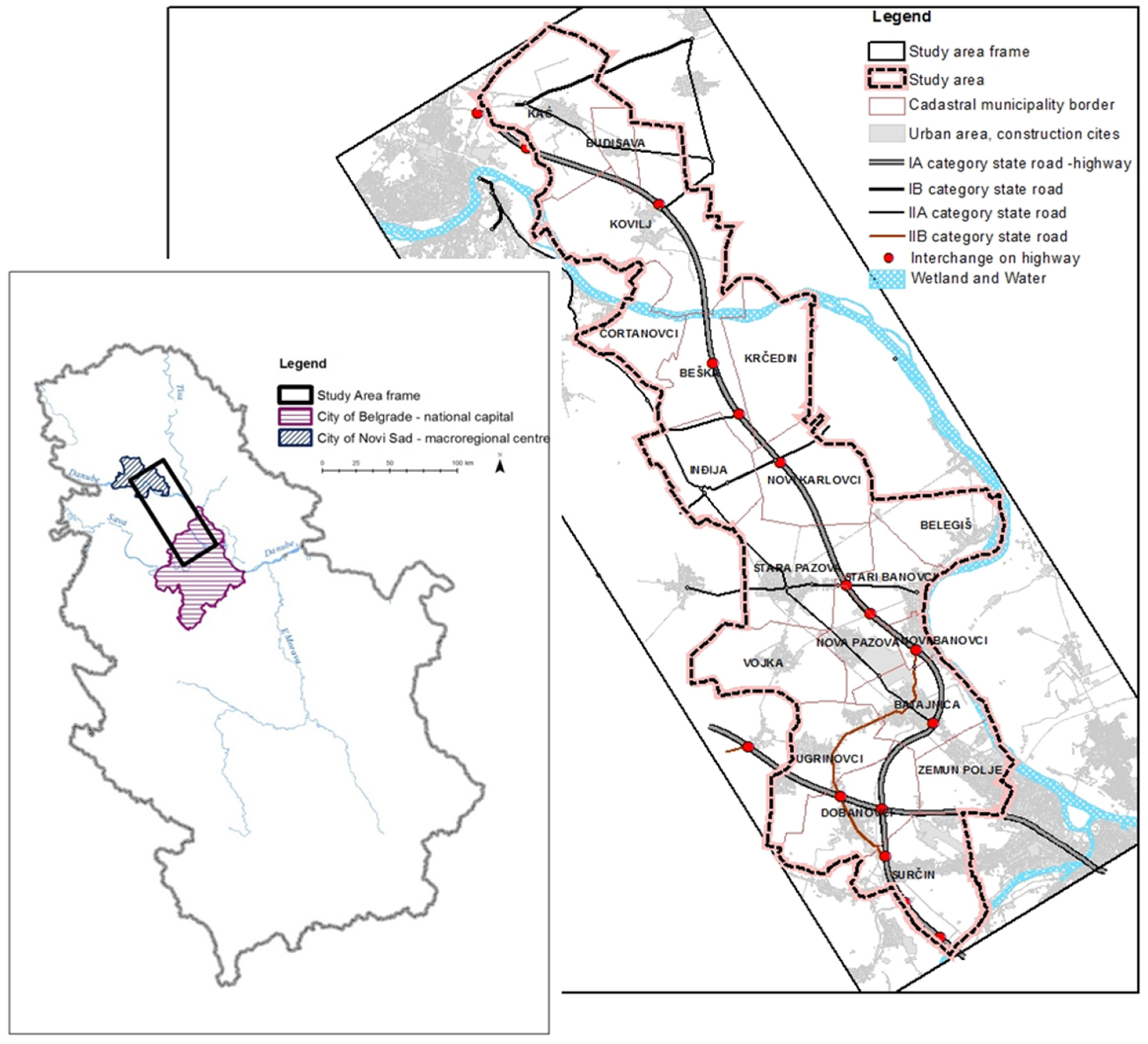
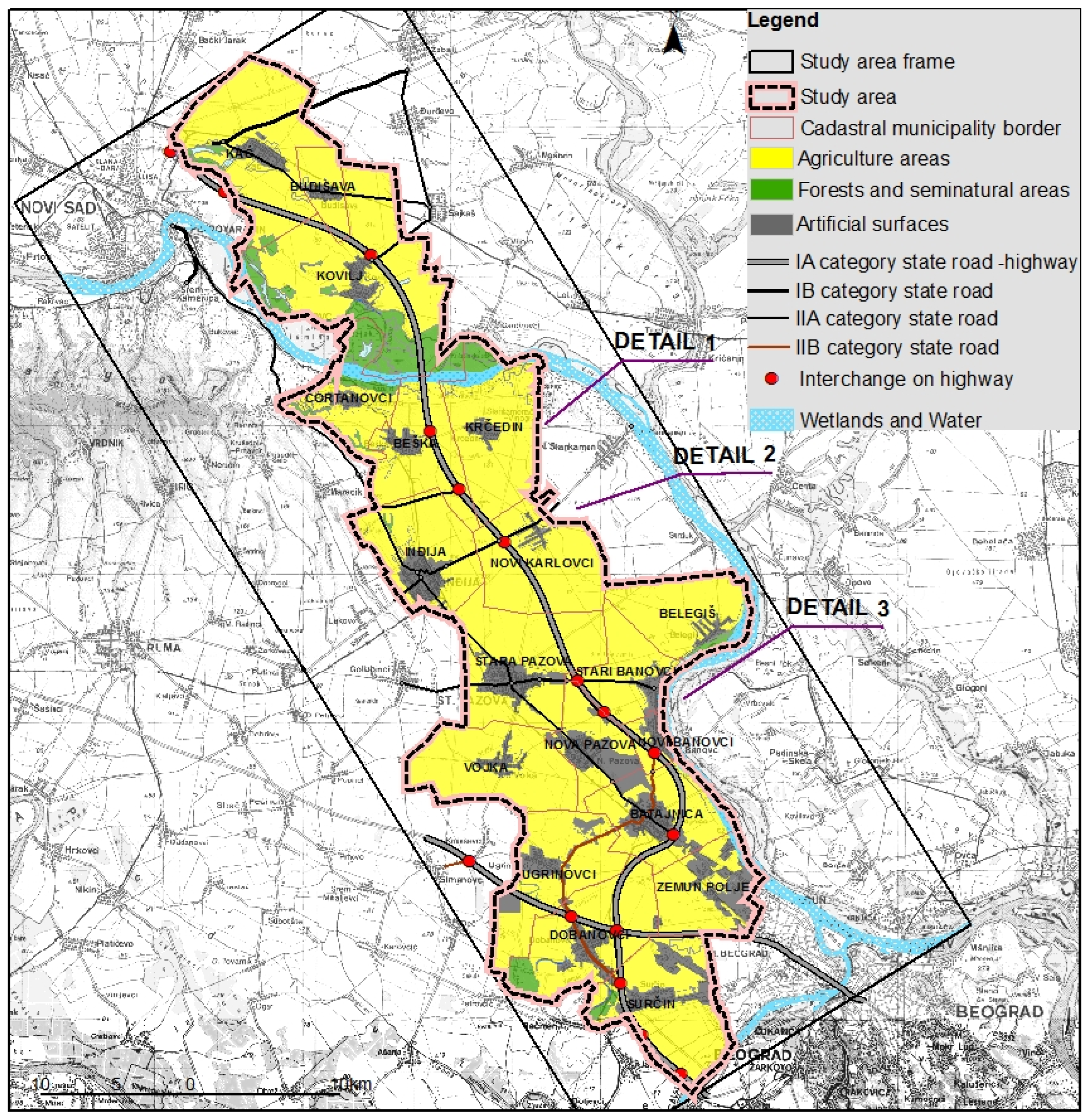
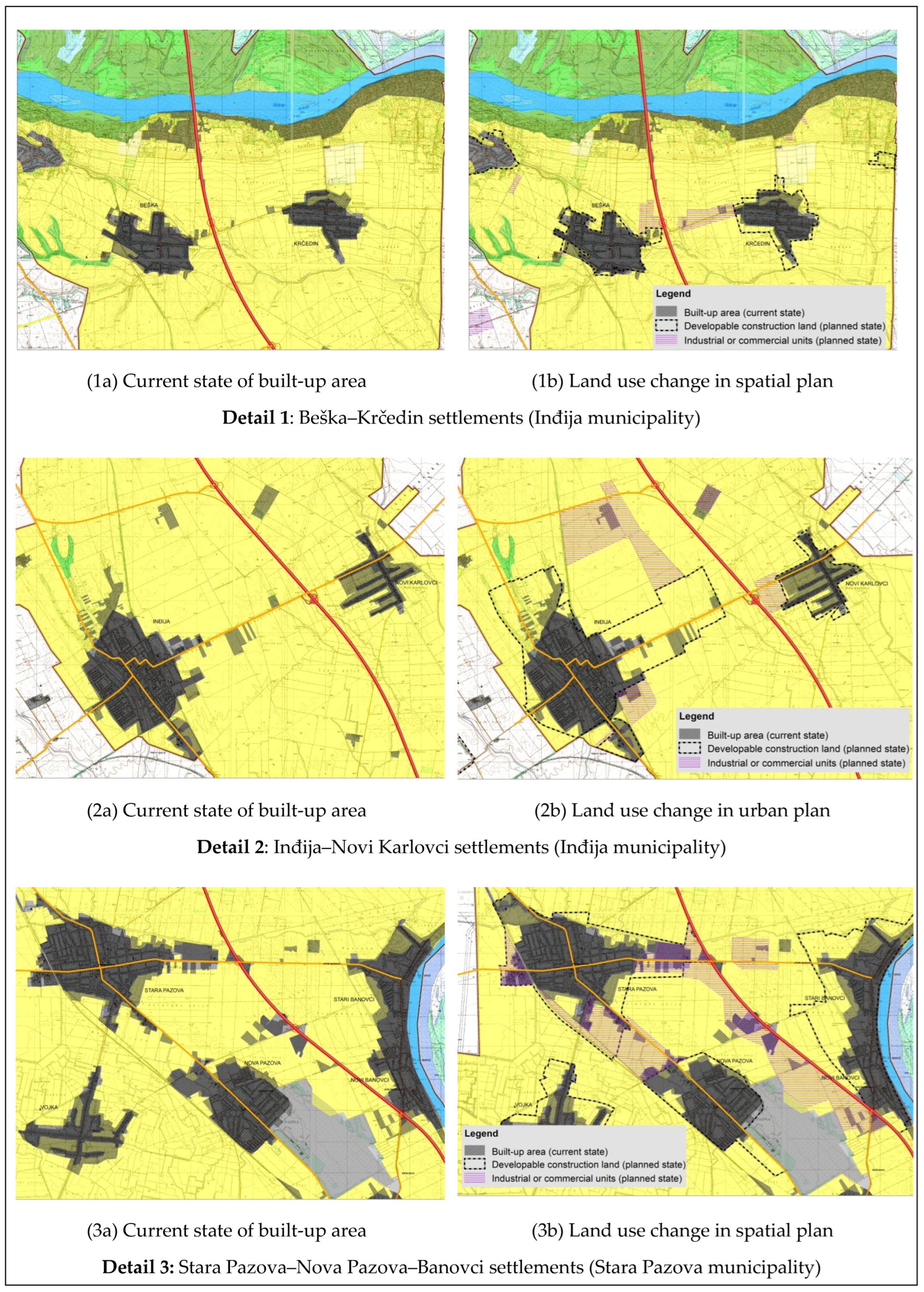
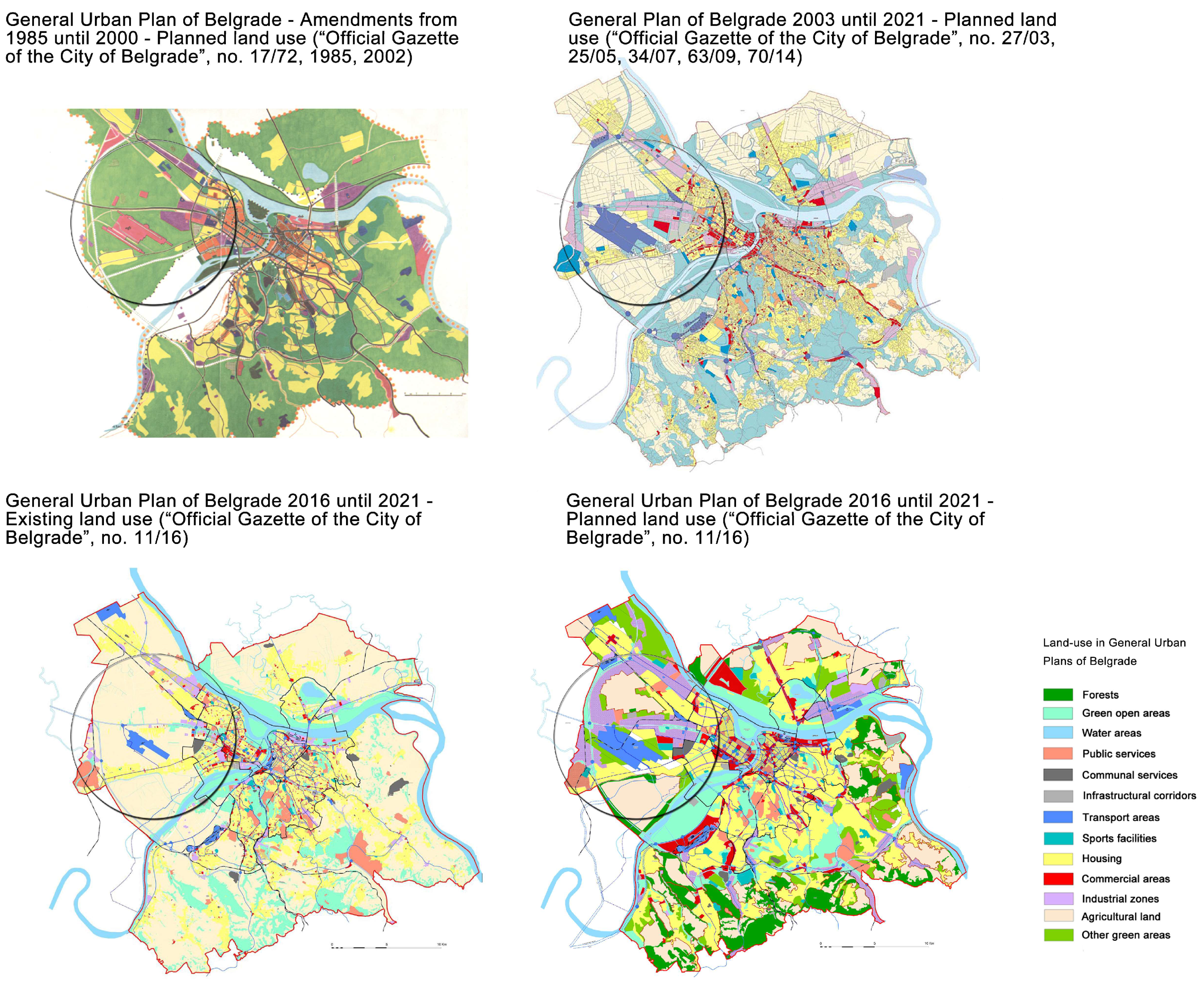
2.1. Study Area

Belgrade is the capital, administrative center and largest city in Serbia, while Novi Sad is the second largest city and an important macroregional urban center. Currently, the Belgrade–Novi Sad metropolitan area is undergoing fast urbanization in relation to the rest of the country. It contains quality agricultural land and spatially attractive zones between the two cities, encompassing a strong infrastructure network with international importance. In this research, the study area comprises 19 settlements within municipalities affiliated to the metropolitan area and the highway impact area, covering around 910 km2 (Figure 1). It should be noted that the Belgrade–Novi Sad metropolitan area in total covers a much wider area than the study area. Along the study area pass two branches of pan-European transport corridor X, with the branch linking Belgrade and Novi Sad with Budapest (national A1 highway) and branch Belgrade–Zagreb–Ljubljana (national A3 highway), as well as corridor VII (Danube River), international railway with an important railway node. Spreading over around 70 km within the study area is State Road IB category No.100, a road with two tracks that represented a main connection between the two cities since 1950s. It remained an important transport communication with Belgrade for numerous settlements along the route. Part of A1 between Belgrade and Novi Sad is in use since 1975.
Borders of the study area are defined on the basis of spatial and urban planning documents considering the impact area of the A1 highway corridor between Belgrade and Novi Sad, with regards to both the normative elements of the plans, as well as the authors’ own elaboration of the available data.

2.2. Data Sources, Data Processing and Methodology

The undertaken research comprises quantitative analysis of complementary sources of data within the GIS platform, thus allowing comparability of data, as well as replenishment of the attribute feature table in line with the requirements of the selected spatial analysis. Corine Land Cover is based on 10 years and 6 years of remote sensing data collection, structuring, cataloging and validation processes. The analysis included the Corine Land Cover (CLC) datasets and related CLC-Change data (the time series 1990, 2000, 2006, 2012 and 2018). To obtain a more detailed land cover and land-use information, the analysis also used the data from Urban Atlas (available for urban areas of Belgrade and Novi Sad) that is, together with CLC, considered a component of the Copernicus Land Monitoring Service [39]. Preliminary results were complemented with the data obtained from content analysis of spatial and urban (regulatory) plans for the study area using the GIS. The synthesis of data from different sources, analysis and interpretation of data for the study area was performed in ArcGIS (ESRI).
Land-use change data is presented in form of land take indicator (LTI) according to the SDG indicator 11.3.1. [40] and EEA land take indicator [20]. Here is adopted the calculation [23,40] of the land take indicator (LTI) as follows:
L T I =   ln (   U r b t + n ) U r b t )   ( y )
where:
  • ln = Natural logarithm;
  • U r b t + n = Surface occupied by urban areas in km2 in the final year;
  • U r b t = Surface occupied by urban areas in km2 at the initial year;
  • and y = the number of years between the two measurement periods.
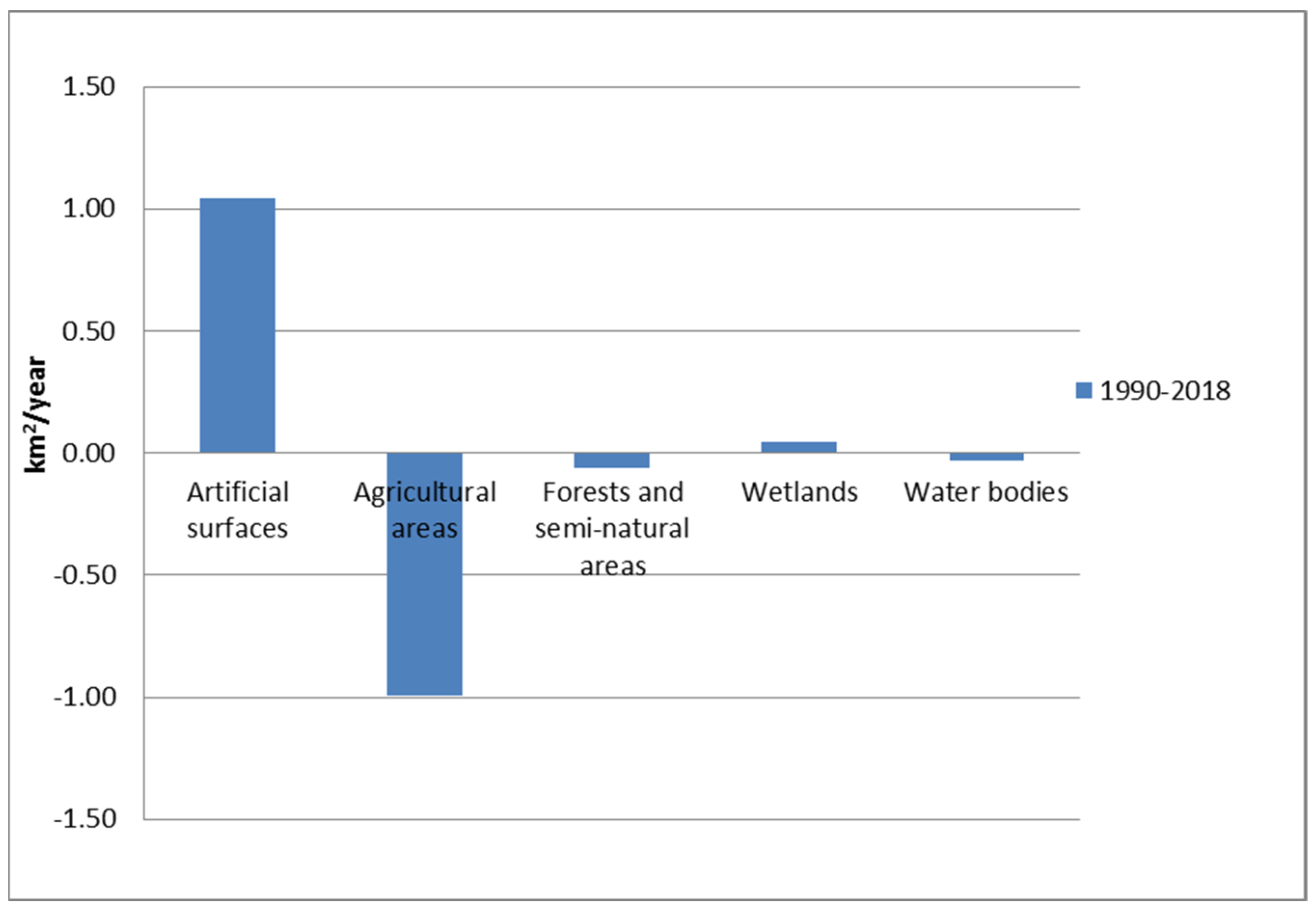
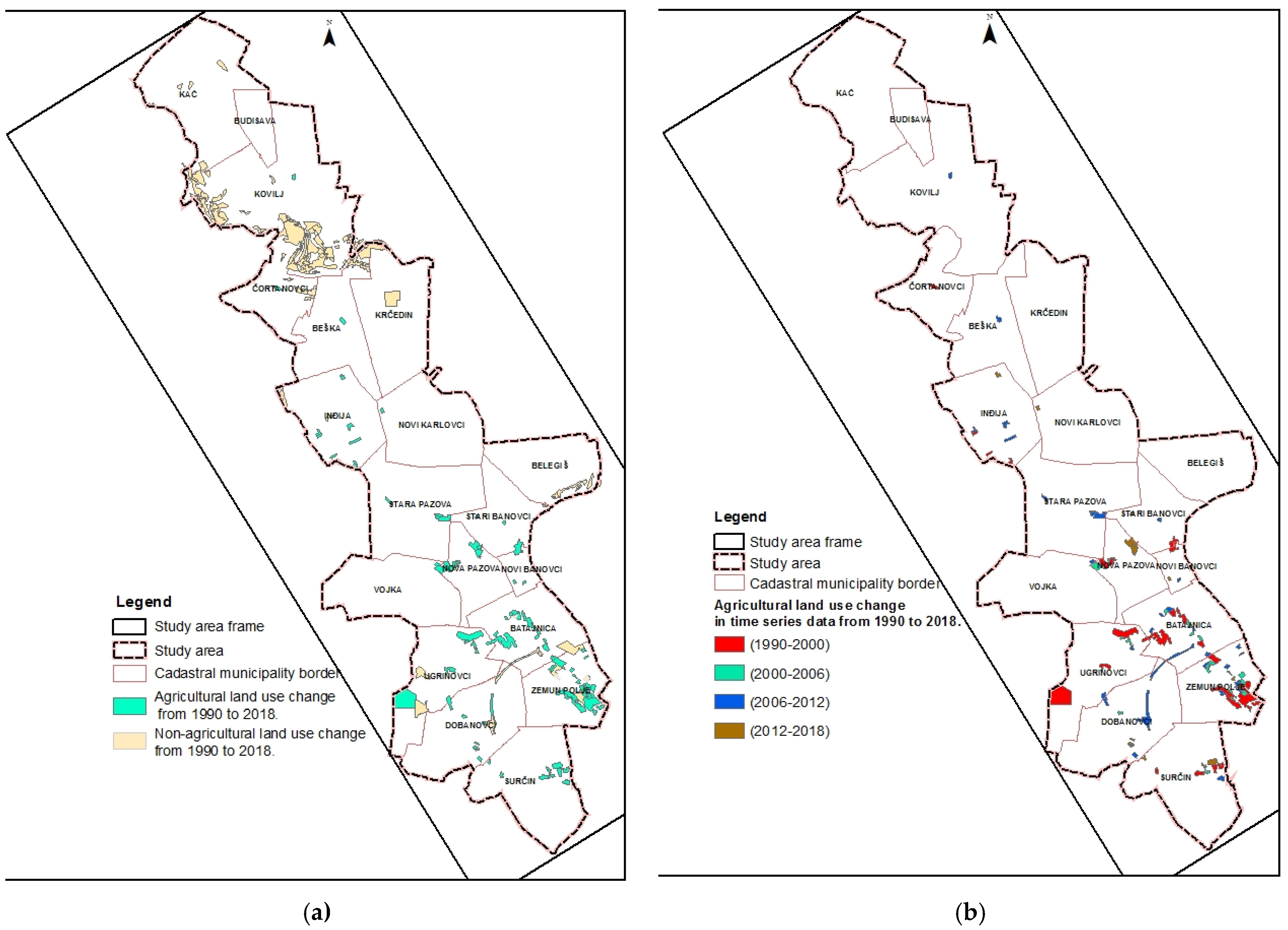
Besides comprehensive studies [23,41], there is no available record of extensive application of this indicator yet. It should be noted that the structure of CLC-Change data cannot detect small-scale land-use changes (cf. [23]) for the areas that are not covered by Urban Atlas data (area between the City of Belgrade and City of Novi Sad, Figure 1, left image). Taking this factor into account, the GIS-based results are contextualized through qualitative content analysis of the available planning documentation in the study area.

3. Results

Observing the basic land cover structure (2018), from the total area (908.9 km2), agricultural land dominates and is represented by 77.9%, artificial surfaces 13.0%, wetlands and water 2.8%, and forests and seminatural areas 6.4%. (Figure 2).
From 1990 to 2018, land take consumed 3.1% of agricultural lands that was converted to industrial and commercial land use and further changed due to the expansion of residential housing areas. Observing all Corine Land Cover in study period, areas containing agricultural land have reduced by 100 ha per year. “Artificial surfaces” have increased at the same pace (Figure 3).
Using the formula for calculating the land take indicator, the value obtained for the period 1990–2018 is:
L T I =   ln (   U r b 2018 U r b 1990 )   ( y ) =   ln (   117.96 88.80 )   ( 28 ) = 0.01  
Compared to land take at European level (cf. [20]), this is not considered an important change.
A more detailed insight into the land-use change through the Land Cover Changes (LCC) database suggests that in the observed period of ca. 30 years, out of the total number of all recorded cases (polygons) recoding land-use change, around 45% of polygons show the change from the category of agricultural land use to the category of artificial land use (Figure 4a). The results point out the parts of the study area in which these changes were more distinct, as well as the dynamic of land-use change in the time series from 1990 to 2018 (Figure 4b).
Data from Figure 4b is presented in the table showcasing the dynamics of agricultural land-use change through different time series (Table 1).
As previously discussed, some of the land-use changes that imply agricultural LT in the period between the 1990s and 2000s are related to the intensive illegal construction (particularly in the peri-urban areas of Belgrade) due to the forced resettlement of population from other ex-Yugoslav countries and the pressing housing demand in Serbian cities. The period after 2006 is characterized by the accelerated transition to a market economy, the arrival of large-scale retail in Serbia and their need for the most suitable accommodation close to main economic activities. These local conditions caused changes from agricultural land to construction land in the near proximity of smaller cities that have a good connection to the highway and are close to larger economic activities in Belgrade and Novi Sad. In these areas, land is more affordable than the land close to big cities, while the infrastructure is being arranged for economic activities. In the period after 2012, the process of agricultural land loss was slowed down, if compared to previous periods. This notion can be linked to adoption of urban policy that required a strict definition of work zones within the construction areas of settlements through spatial and urban plans. Some of the identified land-use changes are further contextualized through analysis of planning documentation within the borders of the study area.
Surveys in 1990, 2000, 2012 and 2016 CORINE Land Cover (CLC) and Land Cover Changes (LCC) datasets revealed some of the most prominent agricultural land-use change dynamics in the study area. Still, there are limitations in the spatial resolution of CLC and LCC, which include: minimum mapping unit (MMU) 25 ha (status layer), 5 ha (change layer), NUTS-3 level, equivalent scale 1:250,000 (status layer), 1:100,000 (change layer) had to be considered in the analysis, as well. These are more significant land-use change than the results presented in Figure 4 and Table 1, which should be considered an important factor in spatial and urban planning.
As an illustration of the agricultural land-use change that falls within the aforementioned category, three characteristic locations within the study Area are distinguished. For those locations, the data referring to built-up areas are supplemented by topographic and ortho-photo maps of higher resolution. The positions of selected locations are marked by labels Detail 1, Detail 2 and Detail 3 on the general map of Figure 2. Figure 5 shows a detailed elaboration of agricultural land-use change along the following interchanges: Beška–Krčedin settlements (Detail 1a), Inđija–Novi Karlovci settlements (Detail 2a), Stara Pazova–Nova Pazova–Banovci settlements (Detail 3a). The extensive agricultural land-use change along the access roads from the settlements to the highway is clearly identified.
Further research of the current planning documents indicated future tendencies in agricultural land take within the study area. Figure 5 shows planned land-use change within the observed locations on the basis of formal spatial and urban plans (Detail 1b, Detail 2b, Detail 3b, respectively). In some of the designated planning documents within the study area, the reduction of agricultural land occurs mainly for the purpose of developing industrial and commercial units outside the construction area of the settlements. According to the planning documentation for Inđija and Stara Pazova municipalities, there is a clear tendency for encouraging greenfield investments and new housing in peripheral urban and suburban areas, especially in the settlements along the main highway corridors. Taking into account the high quality of land in these areas, the planned construction may even cover about 70% of meadow–black soil and about 30% of chernozem [43].
In addition to the above details, Figure 4 and Table 1 illustrate the most intense agricultural land-use change to non-agricultural land in the municipalities in the immediate vicinity of Belgrade. These findings are supported in formally adopted planning documents that allocate planned land use for the wider area of the city of Belgrade. Urban and rural development is defined in the spatial plans of local self-government units (municipalities) and urban plans, as one of the land-use management instruments defined by law [30]. Generations of General Urban Plans (i.e., master plans) for Belgrade (1972, am. 1985, am. 2002) aimed to restrict new development on existing agricultural land in the peri-urban area of the city, covering the cadastral municipalities of Surčin, Zemun Polje, Batajnica and Dobanovci (Figure 6). However, the planned land-use for this area in the General Urban Plan from 2003 [46] and in the General Urban Plan from 2016 [47] directed intensive development of the industrial and commercial units in the proximity of the infrastructural corridors (i.e., in the area of Belgrade Airport Nikola Tesla and Belgrade–Novi Sad Highway Corridor, marked in purple color in Figure 6) and allocated extensive agricultural zones for the housing land use (marked in yellow color in Figure 6).
Agricultural land that was occupied for the purpose construction of new settlements or for development of industrial and commercial units on the outskirts of Belgrade became recognized as developable construction land in lower-level planning documents as well (i.e., General Regulation Plan of Belgrade [49]).

4. Discussion

Agricultural land is nominally considered to be one of the principal natural resources in Serbia. However, recent quantitative analysis of spatial and urban land-use plans and policies at the local level has shown tendencies of a long-term reduction of the scope of agricultural land [25]. The intentions for reduction of agricultural land were underpinned by requirements for new developments in public ownership (i.e., construction of public infrastructure, energy, water facilities, etc.) as well as for other developments that are not publicly owned (i.e., housing, industrial and commercial units) [25]. Within the planning determinants that have significantly affected the spatial development of municipalities and cities, the use and protection of agricultural land is most often marginalized. The dominant planning decision to stop the illegal construction and degradation of land can be inconsistently applied as a measure in urban plans, or occurs “on ground” without the adoption of comprehensive planning policy. The concept of sustainable development in urban agriculture and use of land in accordance with its ecological properties has been promoted only recently. The new SPRS proclaims the use of existing construction supply (brownfield instead greenfield investments) for new activities and uses where possible [27]. Planning of “greenfield” land-use is considered in the line with the neo-liberalist global policy agenda in which urban planning is “more about promoting economic development and less about regulating land and guiding future development” (Fainstein, 1991; Gerber, 2016 as cited in [8]). However, in order to continuously and prospectively ensure “no net land take”, innovative and more targeted instruments are needed in spatial planning and governance [23]. At the same time, there is an established relationship between traditional planning instruments at the local level, such as zoning regulations, and protection and preservation of agricultural areas and urban agriculture [50,51,52]. Many countries and cities are already enforcing stricter laws to protect highly fertile agricultural land in their rural hinterlands [53], while some other examples emphasize the weakness of municipal land-use planning practices in limiting urban sprawl and protecting agricultural and natural heritage [54].
The results of this research relate to: (1) the identified dynamic in agricultural land-use change into construction land; (2) tendencies of continuality of such processes; and (3) systemic support to agricultural land-use change in planning policy. The possibility of changing agricultural into construction land use was first introduced in the Law on Planning, Spatial and Settlement Development [55] for the use of the rural community. This decision was further reinforced in the Law on Planning and Construction (2003) [56] after public land became a commodity. The incentives for agricultural land-use change to developable construction land were supported through the Law on Legalization of Buildings [57], which regulates the conditions, procedure and method of legalization of buildings, and parts of the building built without a construction permit (i.e., illegally built buildings), to allow the approval for development and/or registration in the cadaster. These actions provided an incentive for continuity with regards to illegal construction on agricultural land. The decades of restricting construction on agricultural land in the planning legislation until the 1980s has intensified the aforementioned conflicts in land use [55]. From 1991–2011, urban sprawl in the Belgrade metropolitan area affected the increase in land consumption by 2.9 times (i.e., to 670 m2 per person), which was significantly higher than in other European cities [34]. The wider area of Europe (EEA) reports the rate of 7.7% LT intensity of the total urban area expanded to cover agricultural and semi-natural land for the period 2000–2018 [58]. It should be noted that grid resolution between the EEA reports and the study area analysis significantly diverges, as previously elaborated in the Results section.
The study area belongs to the radius of intense agriculture, which requires further planning activities to support the designated use of agricultural land, the establishment of effective mechanisms to control the implementation of appropriate urban and spatial planning measures, as well as prevention of excessive occupation of fertile land for non-agricultural purposes, especially in the peripheral zones or along traffic corridors [44,45]. Still, agricultural production is highly dependent on the volume and quality of land resources, which are limited and practically non-renewable.
The proximity of large urban centers (Belgrade, Novi Sad) conditioned that the attractivity of the agricultural land within the study area is to be highly attractive for investors/developers. There are studies that address the loss of cultivated land and other natural and semi-natural land types, and the change to construction land for the purpose of highway development, where “the road has become the axis of regional urban expansion” [10]. The improvement of regional accessibility, reduction of the economic production cost and improvement of the suitable functions of the land along the corridor line, result in the rapid expansion of the construction land area [10]. With time, this became the case along the Belgrade–Novi Sad highway and local roads. Agricultural land changed between the observed periods from being clustered to scattered along the road (Figure 4a,b). Spontaneous and uncontrolled urban growth and intense expansion of construction areas (planned as well as illegal ones), with extremely inefficient use of construction land and excessive and prevailing agricultural land-use change, were recognized as one of the most significant challenges in terms of the efficient use of construction land [36]. This can be considered an effect of unreliable law enforcement and construction inspection, as well as the issuance of inadequate construction permits, which contributed to the accelerated illegal development on publicly owned land at the periphery of cities [59,60], but also planned expansion of industrial and commercial units at the expense of agricultural land.

5. Conclusions

The issue of agricultural land-use change and LT is recognized worldwide, especially regarding the global crises in food security. Taking into account that in Serbia LT is predominantly enabled through urban sprawl, the role of spatial and urban planning comes to the forefront of the debate related to the competing land uses.
The results of the undertaken quantitative and qualitative research point out that agricultural LT has been taking place through agricultural land-use change in the study area, mostly in the form of urban sprawl. The main drivers of LT within the study area are recognized: the force of attraction of Belgrade and Novi Sad, commercial and industrial activities, previous illegal construction and transportation (highway). Even though land-use planning is considered a factor that reduces LT, the undertaken analysis of the formal planning documentation for the study area affirms new LT through land-use change and orientation from agricultural to other activities in the field of economic development (commercial, industrial, etc.). These findings are supported by the previous research of agricultural land-use change in Serbia [26], in which the planning decisions at the municipality level would be a highly relevant complementary source of data. We recognize the importance of future research and analysis of agricultural land-use change and LT spatial and temporal dynamics, which is currently scarce in the research of planning practice in Serbia. Hence, a scientific and expert-based debate in that field may be directed on the conflict between the profit-oriented land-use change on the one hand and the preservation of agricultural land on the other. Moreover, it is important to question the validity regarding the expansion of industrial units, commercial activities (e.g., shopping malls) and housing, etc., on high-quality agricultural land and open areas. Planning solutions should aspire to reduce agricultural land take (hence, sealing) to zero, while seeking for and balancing realistic needs with development and investment interests. Thus, the land-use change of now undeveloped open space into new developments and agricultural land fragmentation should be avoided. Along with empirical importance, the GIS-based analysis can be used for understanding and providing input for the land-use management, future planning and governance. In addition, the research results reinforce the need for comprehensive analyses of the consequences of unregulated, but also of designated, land take and agricultural land-use change into construction land in the observed highway corridor, as well as in Serbia.

Author Contributions

Conceptualization, J.Ž.M. and O.D.; methodology, J.Ž.M. and O.D.; software, O.D.; validation, J.Ž.M. and N.Č.; formal analysis, J.Ž.M.; investigation, J.Ž.M.; resources, J.Ž.M. and O.D.; data curation, O.D.; writing—original draft preparation, J.Ž.M. and O.D.; writing—review and editing, J.Ž.M. and N.Č.; visualization, O.D. and N.Č. All authors have read and agreed to the published version of the manuscript.

Funding

This research was supported by the Ministry of Education, Science, and Technological Development of the Republic of Serbia (MESTD RS) (contract on the implementation and financing of scientific research work of the scientific research organization in 2022, no. 451-03-68/2022-14/20006).

Conflicts of Interest

The authors declare no conflict of interest.

References

  1. Coulibaly, B.; Li, S. Impact of Agricultural Land Loss on Rural Livelihoods in Peri-Urban Areas: Empirical Evidence from Sebougou, Mali. Land 2020, 9, 470. [Google Scholar] [CrossRef]
  2. Abu Hatab, A.; Rigo Cavinato, M.E.; Lindemer, A.; Lagerkvist, C.-J. Urban sprawl, food security and agricultural systems in developing countries: A systematic review of the literature. Cities 2019, 94, 129–142. [Google Scholar] [CrossRef]
  3. La Rosa, D.; Privitera, R. Characterization of non-urbanized areas for land-use planning of agricultural and green infrastructure in urban contexts. Landsc. Urban Plan. 2013, 109, 94–106. [Google Scholar] [CrossRef]
  4. Gomes, E.; Banos, A.; Abrantes, P.; Rocha, J.; Kristensen, S.B.P.; Busck, A. Agricultural land fragmentation analysis in a peri-urban context: From the past into the future. Ecol. Indic. 2019, 97, 380–388. [Google Scholar] [CrossRef]
  5. Austin, O.C.; Ulunma, A.C.; Sulaiman, J. Exploring the Link between Land Fragmentation and Agricultural Productivity. Int. J. Agric. For. 2012, 2, 30–34. [Google Scholar]
  6. Peiser, R.B.; Hugel, M. Is the Pandemic Causing a Return to Urban Sprawl? J. Comp. Urban Law Policy 2022, 5, 26–41. [Google Scholar]
  7. Kemmerling, B.; Schetter, C.; Wirkus, L. The logics of war and food (in)security. Glob. Food Secur. 2022, 33, 100634. [Google Scholar] [CrossRef]
  8. Hersperger, A.M.; Oliveira, E.; Pagliarin, S.; Palka, G.; Verburg, P.; Bolliger, J.; Grădinaru, S. Urban land-use change: The role of strategic spatial planning. Glob. Environ. Change 2018, 51, 32–42. [Google Scholar] [CrossRef]
  9. Colsaet, A.; Laurans, Y.; Levrel, H. What drives land take and urban land expansion? A systematic review. Land Use Policy 2018, 79, 339–349. [Google Scholar] [CrossRef]
  10. Zheng, F.; Huang, J.; Feng, Z.; Xiao, C. Impact of the Kunming–Bangkok Highway on Land Use Changes along the Route between Laos and Thailand. Land 2021, 10, 991. [Google Scholar] [CrossRef]
  11. Couch, C.; Petschel-Held, G.; Leontidou, L. Urban Sprawl in Europe: Landscape Land-Use Change and Policy; Blackwell Publishing: Hoboken, NJ, USA, 2007. [Google Scholar]
  12. Wandl, A.; Magoni, M. Sustainable Planning of Peri-Urban Areas: Introduction to the Special Issue. Plan. Pract. Res. 2017, 32, 1–3. [Google Scholar] [CrossRef]
  13. European Environment Agency (EEA). Urban Sprawl in Europe. The Ignored Challenge; EEA Report No 10/2006; European Environment Agency (EEA): Copenhagen, Denmark, 2006. [Google Scholar]
  14. European Environment Agency and Federal Office for the Environment Urban sprawl in Europe, Joint EEA-FOEN report. No. 11/2016. Available online: https://www.eea.europa.eu/publications/urban-sprawl-in-europe (accessed on 6 May 2022).
  15. Tardieu, L.; Hamel, P.; Viguié, V.; Coste, L.; Levrel, H. Are soil sealing indicators sufficient to guide urban planning? Insights from an ecosystem services assessment in the Paris metropolitan area. Environ. Res. Lett. 2021, 16, 104019. [Google Scholar] [CrossRef]
  16. EUROSTAT, 2022 Sustainable Development in the European Union Monitoring Report on Progress towards the SDGs in an EU context, Luxembourg: Publications Office of the European Union. Available online: https://ec.europa.eu/eurostat/documents/3217494/14665254/KS-09-22-019-EN-N.pdf/2edccd6a-c90d-e2ed-ccda-7e3419c7c271?t=1654253664613 (accessed on 6 May 2022).
  17. Prokop, G.; Jobstmann, H.; Schönbauer, A. Overview of Best Practices for Limiting Soil Sealing or Mitigating Its Effects in EU-27; Final Report; European Commission, DG Environment: Brussels, Belgium, 2011. [Google Scholar] [CrossRef]
  18. Evers, D.; Van Schie, M.; Van den Broek, L.; Claus, T. SUPER—Sustainable Urbanization and Land-Use Practices in European Regions Main Report. ESPON. 2020. Available online: https://www.espon.eu/sites/default/files/attachments/ESPON%20SUPER%20Final%20Report%20-%20Main%20report_newtemplate.pdf (accessed on 21 February 2022).
  19. Communication from the Commission to the European Parliament. The Council. The European Economic and Social Committee and the Committee of the Regions. Roadmap to a Resource Efficient Europe. COM(2011) 571. Available online: https://ec.europa.eu/environment/resource_efficiency/pdf/working_paper_part1.pdf (accessed on 6 May 2022).
  20. European Environment Agency (EEA). The European Environment—State and Outlook 2020. Knowledge for Transition to a Sustainable Europe; Publication Office of the European Union: Luxembourg, 2019. [Google Scholar] [CrossRef]
  21. United Nations, General Assembly. Transforming Our World: The 2030 Agenda for Sustainable Development; Resolution A/RES/70/1; United Nations: New York, NY, USA, 2015. [Google Scholar]
  22. United Nations, Department of Economic and Social Affairs, Population Division. World Urbanization Prospects 2018: Highlights (ST/ESA/SER.A/421), 2019. Available online: https://population.un.org/wpp/Publications/ (accessed on 6 May 2022).
  23. Marquard, E.; Bartke, S.; Gifreu, I.; Font, J.; Humer, A.; Jonkman, A.; Jürgenson, E.; Marot, N.; Poelmans, L.; Repe, B.; et al. Land Consumption and Land Take: Enhancing Conceptual Clarity for Evaluating Spatial Governance in the EU Context. Sustainability 2020, 12, 8269. [Google Scholar] [CrossRef]
  24. Bousbaine, A.; Akkari, C.; Bryant, C. What can agricultural land use planning contribute to food production and food policy. Int. J. Avian Wildl. Biol. 2017, 2, 13–20. [Google Scholar] [CrossRef]
  25. Živanović Miljković, J.; Čolić, N. Extent of Agricultural Land Use Changes—Experiences and Recommendations for Local Level of Planning and Management. In Theoretical, Development and Applied Research of Spatial Processes for Renewal of Strategic Thinking and Governance in Serbia; Petrić, J., Vujošević, M., Eds.; IAUS: Belgrad, Serbia, 2020; pp. 87–103. (In Serbian) [Google Scholar]
  26. Živanović Miljković, J.; Popović, V.; Gajić, A. Land Take Processes and Challenges for Urban Agriculture: A Spatial Analysis for Novi Sad, Serbia. Land 2022, 11, 769. [Google Scholar] [CrossRef]
  27. Spatial Plan of the Republic of Serbia 2021-2035—Draft (2021); Ministry of Construction, Transport and Infrastructure: Belgrade, Serbia, 2021.
  28. Law on Agricultural Land. (“Sl. glasnik RS”. br. 62/2006. 65/2008—Dr. Zakon. 41/2009. 112/2015. 80/2017 i 95/2018—Dr. Zakon). Available online: https://www.paragraf.rs/propisi/zakon_o_poljoprivrednom_zemljistu.html (accessed on 20 March 2022).
  29. Strategy of Agriculture and Rural Development of the Republic of Serbia 2014–2024. Official Gazette of the Republic of Serbia. 85/2014. Available online: https://www.pravno-informacioni-sistem.rs/SlGlasnikPortal/eli/rep/sgrs/vlada/strategija/2014/85/1 (accessed on 20 March 2022).
  30. Law on Planning and Construction. (“Official Gazette of RS”, no. 72/2009. 81/2009—Amm., 64/2010—Dec. US. 24/2011. 121/2012. 42/2013—Dec. US. 50/2013—Dec. US. 98/2013—Dec. US. 132/2014. 145/2014. 83/2018. 31/2019. 37/2019—Other Law 9/2020 and 52/2021). Available online: https://www.paragraf.rs/propisi/zakon_o_planiranju_i_izgradnji.html (accessed on 20 March 2022).
  31. Vidojević, D.; Baćanović, N.; Dimić, B.; Lazić-Krunić, M.; Jovičić, M.; Popović, S.; Redžić, N.; Dukić, I.; Jevtić, N. Agriculture and environment in the Republic of Serbia—Overview of Indicators; Agency of Environmental Protection: Belgrade, Serbia, 2016. (In Serbian)
  32. Dabović, T.; Pjanović, B.; Tošković, O.; Djordjević, D.; Lukić, B. Experts’ Perception of the Key Drivers of Land-Use/Land-Cover Changes in Serbia from 1990 to 2012. Sustainability 2021, 13, 7771. [Google Scholar] [CrossRef]
  33. Vuksanović-Macura, Z.; Radulović, S.; Macura, V. Land cover changes of the Belgrade area over the past three centuries. Spatium 2018, 2, 42–50. [Google Scholar] [CrossRef]
  34. Zeković, S.; Vujošević, M.; Jean-Claude, B.; Cvetinović, M.; Živanović Miljković, J.; Maričić, T. Planning and Land Policy Tools for Limiting Urban Sprawl: The Example of Belgrade. Spatium 2015, 33, 69–75. [Google Scholar] [CrossRef]
  35. Krunić, N.; Gajić, A.; Tošić, D. Development Challenges Faced by Cities in Serbia. The Geography of Serbia Nature, People, Economy 2022; Manić, E., Nikitović, E., Djurović, P., Eds.; Springer: Berlin/Heidelberg, Germany, 2022. [Google Scholar]
  36. Sustainable Urban Development Strategy of the Republic of Serbia until 2030. Official Gazette of the Republic of Serbia, No. 47/2019. Available online: https://www.pravno-informacioni-sistem.rs/SlGlasnikPortal/eli/rep/sgrs/vlada/strategija/2019/47/1/reg (accessed on 20 March 2022).
  37. Dželebdžić, O.; Čolić, N.; Majhenšek, K. Transformation of Small Towns in Serbia—From Urban Decay to New Identity. In Local Self-Government in Planning of Space and Settlements. 9th Scientific and Professional Conference with International Participation—Book of Proceedings; Šećerov, V., Đorđević, D., Radosavljević, Z., Jeftić, M., Eds.; Serbian Spatial Planners Association, Faculty of Geography, University of Belgrade: Belgrade, Serbia, 2022; pp. 71–81. (In Serbian) [Google Scholar]
  38. Petric, J.; Bajic, T.; Danilovic Hristic, N. Urban sprawl of informal settlements in Belgrade, Serbia Models for standardization and reflections on recovery. In Proceedings of the 4th ISUFitaly International Conference, Reading Built Spaces, Cities in the Making and Future Urban Form, Bari, Italy, 26–28 September 2018. [Google Scholar]
  39. Copernicus Land Monitoring Service. Available online: https://land.copernicus.eu (accessed on 10 June 2022).
  40. UNSTATS (2021). SDG Indicator Metadata. Available online: https://unstats.un.org/sdgs/metadata/files/Metadata-11-03-01.pdf (accessed on 20 January 2022).
  41. Nicolau, R.; David, J.; Caetano, M.; Pereira, J.M.C. Ratio of Land Consumption Rate to Population Growth Rate—Analysis of Different Formulations Applied to Mainland Portugal. ISPRS Int. J. Geo-Inf. 2019, 8, 10. [Google Scholar] [CrossRef]
  42. National Spatial Data infrastructure GeoSrbija. Available online: https://geosrbija.rs (accessed on 10 June 2022).
  43. General Regulation Plan of the Municipality of Nova Pazova; No. 32/2018, amendments 37/2018, 4/21; Official Gazette of the Municipality of Srem: Srem, Serbia, 2018.
  44. Spatial Plan of the Municipality of Inđija; No. 7/2012, amendment 27/2018; Official Gazette of the Municipality of Inđija: Inđija, Serbia, 2018.
  45. Spatial Plan of the Municipality of Stara Pazova; No. 12/2009, amendments 17/2012, 38/2013 and 7/2019; Official Gazette of the Municipality of Srem: Srem, Serbia, 2019.
  46. General Urban Plan of Belgrade; no. 27/03, 25/05, 34/07, 63/09, 70/14; Official Gazette of the City of Belgrade: Belgrade, Serbia, 2014.
  47. General Urban Plan of Belgrade; no. 11/16; Official Gazette of the City of Belgrade: Belgrade, Serbia, 2016.
  48. Urban Planning Institute of Belgrade. Available online: https://mape.urbel.com/urbelmape/maps (accessed on 30 August 2022).
  49. General Regulation Plan for Belgrade (Izmene i dopune Plana Generalne Regulacije Građevinskog Područja Sedišta Jedinice lokalne Samouprave—Grad Beograd (celine I–XIX)—(I faza—1.etapa) (2021); No. 72/21.; Official Gazette of the City of Belgrade: Belgrade, Serbia, 2021.
  50. Shirley, M. Food Ordinances: Encouraging Eating Local. Wm. Mary Envtl. L. Pol’y Rev. 2012, 37, 511–537. [Google Scholar]
  51. Maloney, S.A. Putting Paradise in the Parking Lot: Using Zoning to Promote Urban Agriculture. Notre Dame L. Rev. 2012, 88, 2551. [Google Scholar] [CrossRef] [Green Version]
  52. Piorr, A.; Zasada, I.; Doernberg, A.; Zoll, F.; Ramme, W. Research for AGRI Committee—Urban and Peri-Urban Agriculture in the EU.; European Parliament, Policy Department for Structural and Cohesion Policies: Brussels, Belgium, 2018. [Google Scholar]
  53. Zróbek-Rózanska, A.; Zielinska-Szczepkowska, J. National Land Use Policy against the Misuse of the Agricultural Land—Causes and Effects. Evidence from Poland. Sustainability 2019, 11, 6403. [Google Scholar] [CrossRef]
  54. Abrantes, P.; Fontes, I.; Gomes, E.; Rocha, J. Compliance of land cover changes with municipal land use planning: Evidence from the Lisbon metropolitan region (1990–2007). Land Use Policy 2016, 51, 120–134. [Google Scholar] [CrossRef]
  55. Law on Planning, Spatial and Settlement Development; no. 44/95, 23/96, 16/97, 46/98; Official Gazette of the Republic of Serbia: Belgrade, Serbia, 1998.
  56. Law on Planning and Construction; no. 47/03, 34/06; Official Gazette of the Republic of Serbia: Belgrade, Serbia, 2006.
  57. Law on Legalization of Buildings; no. 96/2015, 83/2018 and 81/2020—Constitutional decision; Official Gazette of the Republic of Serbia: Belgrade, Serbia, 2020.
  58. European Environmental Agency, Land take in Europe. Available online: https://www.eea.europa.eu/data-and-maps/indicators/land-take-3/assessment (accessed on 23 September 2022).
  59. Petovar, K. Our Cities between the State and Citizens; Cicero: Belgrade, Serbia, 2003. (In Serbian) [Google Scholar]
  60. Čolić, N.; Nedović-Budić, Z. Public interest as a basis for planning standards in urban development: State-socialist and post-socialist cases in Serbia. J. Plan. Educ. Res. 2021, 0739456X211051421. [Google Scholar] [CrossRef]
Figure 1. The position of the study area in Serbia, Belgrade–Novi Sad Highway Corridor.
Land 11 01691 g001
Figure 2. Land use in the study area 2018 (authors’ elaboration on the basis of CLC 2018 database, UA 2018 database [39] and National Spatial Data Infrastructure GeoSrbija [42]).
Land 11 01691 g002
Figure 3. Yearly land take per major land cover category in study area for period 1990–2018.
Land 11 01691 g003
Figure 4. (a) Agricultural land-use change to other land uses in the period between 1990 and 2018; (b) dynamics of agricultural land-use change in the time series data of 1990–2000–2006–2012–2018.
Land 11 01691 g004
Figure 5. Detailed elaboration of agricultural land-use change [44,45].
Land 11 01691 g005
Figure 6. Generations of General Urban Plans for Belgrade (1985–2016). Source: [48].
Land 11 01691 g006
Table 1. Agricultural land-use change in artificial land-use in times series from 1990 to 2018 (in ha).
Times Series1990–20002000–20062006–20122012–2018Total
Changes from agricultural land use to artificial land use (ha) *1133.45262.92517.90188.872103.13
%53.912.524.69.0100
* Calculated on the basis of Land Cover Changes (LCC) datasets. The data are approximative, although the Change layers have higher resolution than CLC, i.e., minimum mapping unit (MMU) is 5 hectares for Land Cover Changes (LCC).
Publisher’s Note: MDPI stays neutral with regard to jurisdictional claims in published maps and institutional affiliations.

