
To What Extent Is Hydrologic Connectivity Taken into Account in Catchment Studies in the Lake Tana Basin, Ethiopia? A Review

Abstract
:1. Introduction
- Has hydrologic connectivity been taken into account, and what are the main research gaps related to hydrologic connectivity?
- How is the effect of climate, land use and land-water management on hydrological response taken into account?
- What is the relative influence of structural connectivity on runoff response?
- What kind of models were used in connectivity studies, and what are the implications posed by the different kind of models?
- How has the connection between structural and functional connectivity of hydrologic connectivity been taken into account?
2. Materials and Methods
3. Results
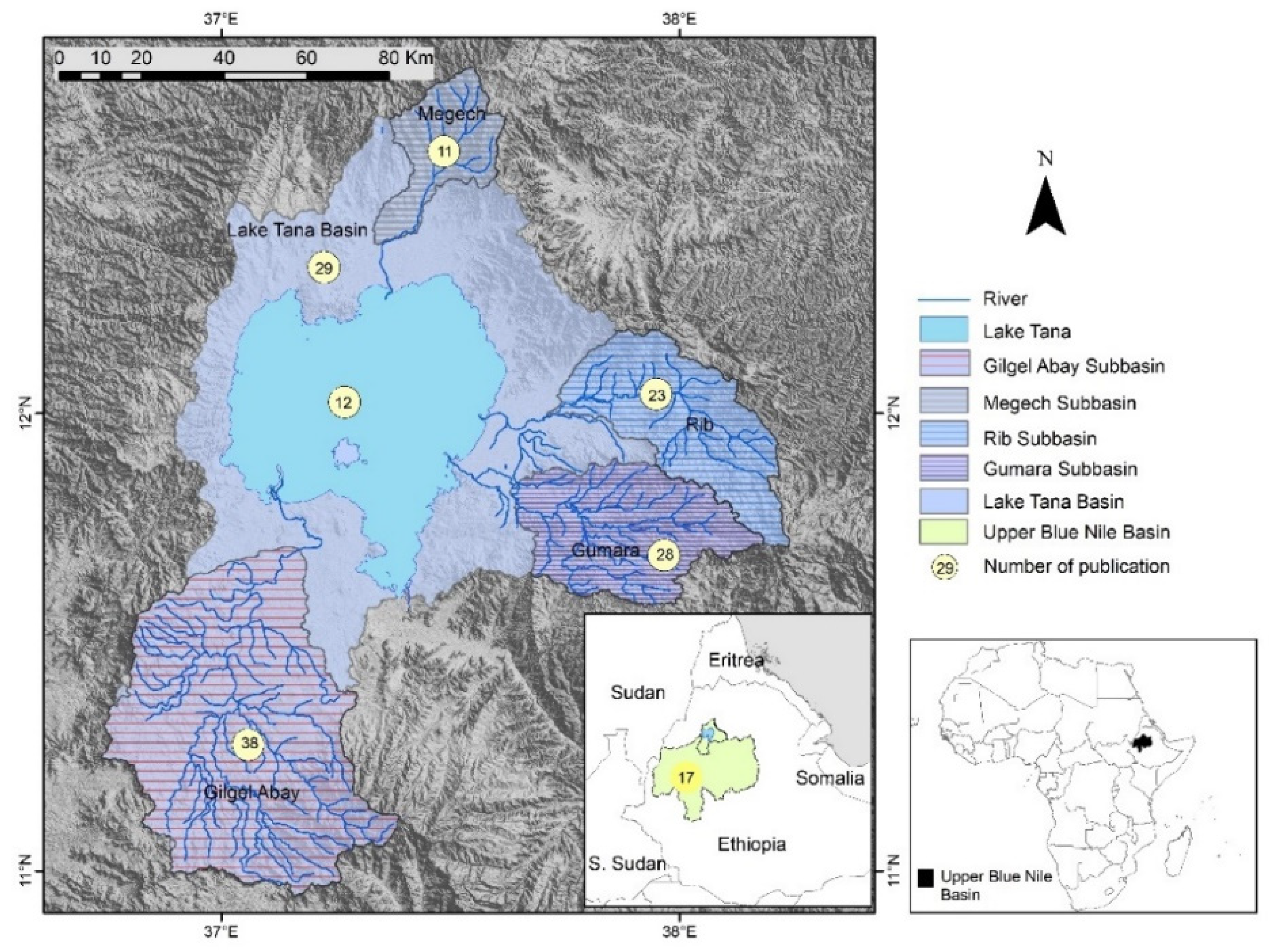
3.1. Spatial Scope
3.2. Assessment Connectivity in the Lake Tana Basin
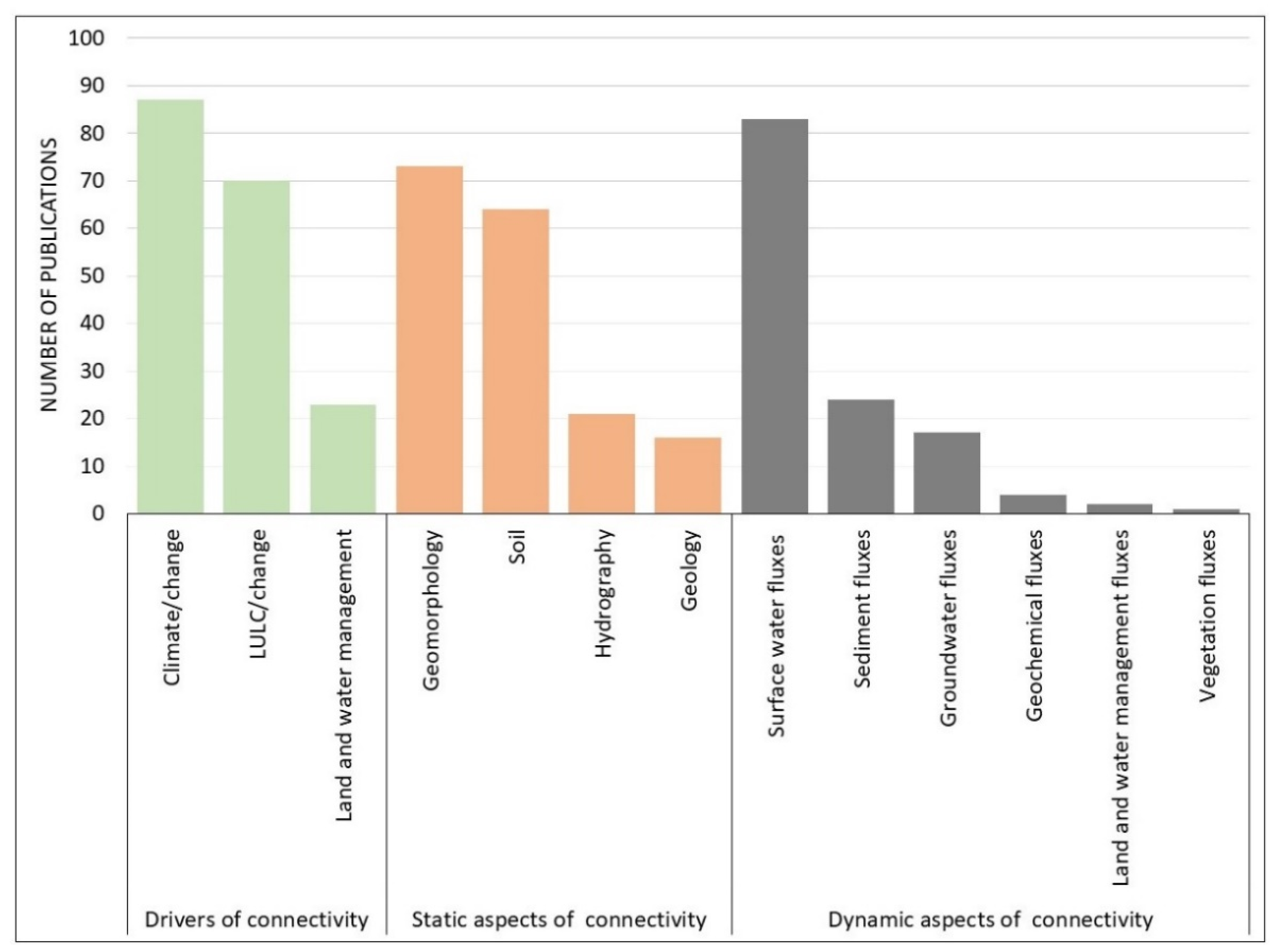
3.3. Drivers, Static, Dynamic Aspect of Connectivity
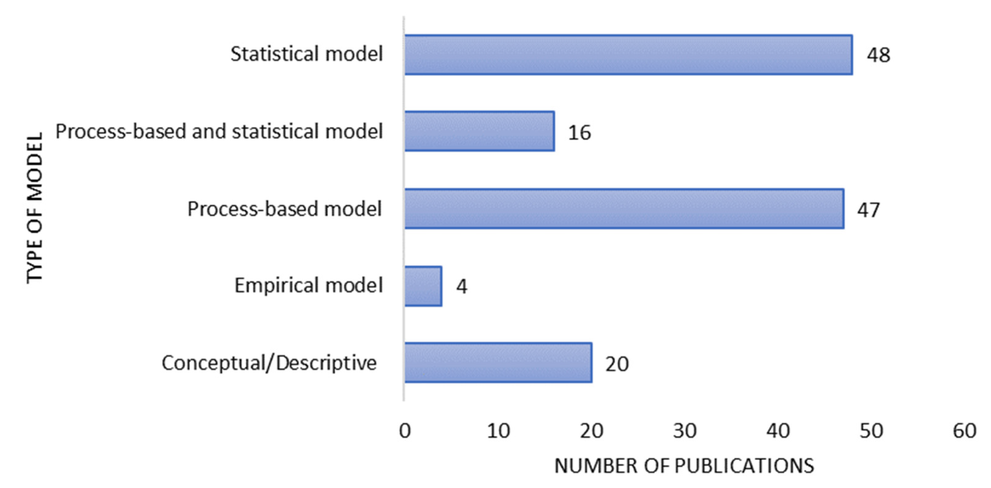
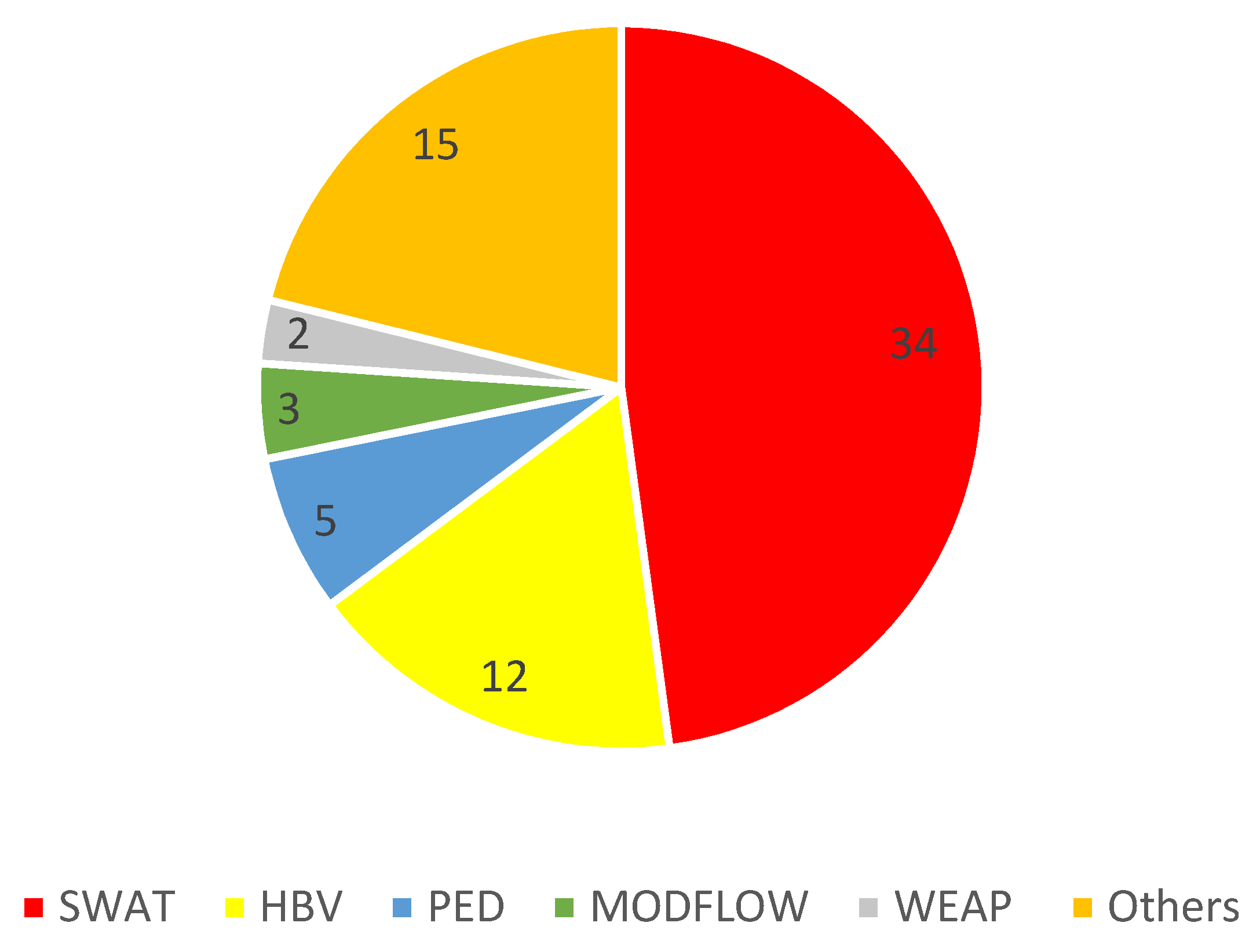
3.4. Modelling Approaches of Studies in the Lake Tana Basin
4. Discussion
5. Conclusions
- More attention has been given to climate variability and climate change and land-use/land-cover change, while little attention has been paid to assess the importance of the static aspect of connectivity on hydrological response and hydrologic connectivity.
- Static aspects of connectivity, such as geology and geomorphology, which affect variation in the water infiltration capacity, as well as the emergence of springs, have received little attention, even though they determine important parameters for hydrological modelling.
- At the basin level, the impact of soil and water conservation measures has hardly been studied, nor has the contribution of gully erosion been taken into account in hydrologic and sediment modelling.
Author Contributions
Funding
Institutional Review Board Statement
Informed Consent Statement
Data Availability Statement
Conflicts of Interest
References
- Bracken, L.J.; Croke, J. The concept of hydrological connectivity and its contribution to understanding runoff-dominated geomorphic systems. Hydrol. Process. 2007, 21, 1749–1763. [Google Scholar] [CrossRef]
- Pringle, C. What is hydrologic connectivity and why is it ecologically important? Hydrol. Process. 2003, 17, 2685–2689. [Google Scholar] [CrossRef]
- Bracken, L.J.; Wainwright, J.; Ali, G.A.; Tetzlaff, D.; Smith, M.W.; Reaney, S.M.; Roy, A.G. Concepts of hydrological connectivity: Research approaches, Pathways and future agendas. Earth-Sci. Rev. 2013, 119, 17–34. [Google Scholar] [CrossRef] [Green Version]
- Bracken, L.J.; Turnbull, L.; Wainwright, J.; Bogaart, P. Sediment connectivity: A framework for understanding sediment transfer at multiple scales. Earth Surf. Process. Landf. 2015, 40, 177–188. [Google Scholar] [CrossRef] [Green Version]
- Masselink, R.J.H.; Heckmann, T.; Temme, A.J.A.M.; Anders, N.S.; Gooren, H.P.A.; Keesstra, S.D. A network theory approach for a better understanding of overland flow connectivity. Hydrol. Process. 2017, 31, 207–220. [Google Scholar] [CrossRef]
- Ali, G.A.; Roy, A.G. Revisiting hydrologic sampling strategies for an accurate assessment of hydrologic connectivity in humid temperate systems. Geogr. Compass 2009, 3, 350–374. [Google Scholar] [CrossRef]
- Tetzlaff, D.; Bacon, P.J.; Youngson, A.F.; Gibbins, C.; Malcolm, I.A. Connectivity between landscapes and riverscapes—A unifying theme in integrating hydrology and ecology in catchment science? Hydrol. Process. 2007, 21, 1385–1389. [Google Scholar] [CrossRef]
- Stieglitz, M.; Shaman, J.; McNamara, J.; Engel, V.; Shanley, J.; Kling, G.W. An approach to understanding hydrologic connectivity on the hillslope and the implications for nutrient transport. Glob. Biogeochem. Cycles 2003, 17, 1105. [Google Scholar] [CrossRef]
- Western, A.W.; Blöschl, G.; Grayson, R.B. Toward capturing hydrologically significant connectivity in spatial patterns. Water Resour. Res. 2001, 37, 83–97. [Google Scholar] [CrossRef]
- Ocampo, C.J.; Sivapalan, M.; Oldham, C. Hydrological connectivity of upland-riparian zones in agricultural catchments: Implications for runoff generation and nitrate transport. J. Hydrol. 2006, 331, 643–658. [Google Scholar] [CrossRef]
- Masselink, R.J.H.; Keesstra, S.D.; Temme, A.J.A.M.; Seeger, M.; Giménez, R.; Casalí, J. Modelling Discharge and Sediment Yield at Catchment Scale Using Connectivity Components. Land Degrad. Dev. 2016, 27, 933–945. [Google Scholar] [CrossRef]
- Borselli, L.; Cassi, P.; Torri, D. Prolegomena to sediment and flow connectivity in the landscape: A GIS and field numerical assessment. Catena 2008, 75, 268–277. [Google Scholar] [CrossRef]
- Ali, G.A.; Roy, A.G. Shopping for hydrologically representative connectivity metrics in a humid temperate forested catchment. Water Resour. Res. 2010, 46, 1–24. [Google Scholar] [CrossRef]
- Meerkerk, A.L.; Van Wesemael, B.; Bellin, N. Application of connectivity theory to model the impact of terrace failure on runoff in semi-arid catchments. Hydrol. Process. 2009, 23, 2792–2803. [Google Scholar] [CrossRef]
- Callow, J.N.; Smettem, K.R.J. The effect of farm dams and constructed banks on hydrologic connectivity and runoff estimation in agricultural landscapes. Environ. Model. Softw. 2009, 24, 959–968. [Google Scholar] [CrossRef]
- Keesstra, S.; Nunes, J.P.; Saco, P.; Parsons, T.; Poeppl, R.; Masselink, R.; Cerdà, A. The way forward: Can connectivity be useful to design better measuring and modelling schemes for water and sediment dynamics? Sci. Total Environ. 2018, 644, 1557–1572. [Google Scholar] [CrossRef]
- Turnbull, L.; Wainwright, J.; Brazier, R.E. A conceptual framework for understanding semi-arid land degradation: Ecohydrological interactions across multiple-space and time scales. Ecohydrology 2008, 1, 23–34. [Google Scholar] [CrossRef] [Green Version]
- Okin, G.S.; De Las Heras, M.M.; Saco, P.M.; Throop, H.L.; Vivoni, E.R.; Parsons, A.J.; Wainwright, J.; Peters, D.P.C. Connectivity in dryland landscapes: Shifting concepts of spatial interactions. Front. Ecol. Environ. 2015, 13, 20–27. [Google Scholar] [CrossRef] [Green Version]
- Knudby, C.; Carrera, J. On the relationship between indicators of geostatistical, flow and transport connectivity. Adv. Water Resour. 2005, 28, 405–421. [Google Scholar] [CrossRef]
- Lexartza-Artza, I.; Wainwright, J. Hydrological connectivity: Linking concepts with practical implications. Catena 2009, 79, 146–152. [Google Scholar] [CrossRef]
- Baartman, J.E.M.; Nunes, J.P.; Masselink, R.; Darboux, F.; Bielders, C.; Degré, A.; Cantreul, V.; Cerdan, O.; Grangeon, T.; Fiener, P.; et al. What do models tell us about water and sediment connectivity? Geomorphology 2020, 367, 107300. [Google Scholar] [CrossRef]
- Kirkby, M.; Bracken, L.; Reaney, S. The influence of land use, soils and topography on the delivery of hillslope runoff to channels in SE Spain. Earth Surf. Process. Landf. 2002, 27, 1459–1473. [Google Scholar] [CrossRef]
- Garbin, S.; Celegon, E.A.; Fanton, P.; Botter, G. Hydrological controls on river network connectivity. R. Soc. Open Sci. 2019, 6, 181428. [Google Scholar] [CrossRef] [PubMed]
- Stavi, I.; Rachmilevitch, S.; Yizhaq, H. Small-scale Geodiversity Regulates Functioning, Connectivity, and Productivity of Shrubby, Semi-arid Rangelands. Land Degrad. Dev. 2018, 29, 205–209. [Google Scholar] [CrossRef]
- Poeppl, R.E.; Keesstra, S.D.; Maroulis, J. A conceptual connectivity framework for understanding geomorphic change in human-impacted fluvial systems. Geomorphology 2017, 277, 237–250. [Google Scholar] [CrossRef]
- López-Vicente, M.; Nadal-Romero, E.; Cammeraat, E.L.H. Hydrological Connectivity Does Change over 70 Years of Abandonment and Afforestation in the Spanish Pyrenees. Land Degrad. Dev. 2017, 28, 1298–1310. [Google Scholar] [CrossRef] [Green Version]
- Deng, X.; Xu, Y.; Han, L. Impacts of human activities on the structural and functional connectivity of a river network in the Taihu Plain. Land Degrad. Dev. 2018, 29, 2575–2588. [Google Scholar] [CrossRef]
- Lizaga, I.; Quijano, L.; Palazón, L.; Gaspar, L.; Navas, A. Enhancing Connectivity Index to Assess the Effects of Land Use Changes in a Mediterranean Catchment. Land Degrad. Dev. 2018, 29, 663–675. [Google Scholar] [CrossRef] [Green Version]
- Steele, M.K.; Heffernan, J.B. Morphological characteristics of urban water bodies: Mechanisms of change and implications for ecosystem function. Ecol. Appl. 2014, 24, 1070–1084. [Google Scholar] [CrossRef]
- Wohl, E.; Brierley, G.; Cadol, D.; Coulthard, T.J.; Covino, T.; Fryirs, K.A.; Grant, G.; Hilton, R.G.; Lane, S.N.; Magilligan, F.J.; et al. Connectivity as an emergent property of geomorphic systems. Earth Surf. Process. Landf. 2019, 44, 4–26. [Google Scholar]
- Bires, Z.; Raj, S. Determinants of environmental conservation in Lake Tana Biosphere Reserve, Ethiopia. Heliyon 2019, 5, e01997. [Google Scholar] [CrossRef] [PubMed]
- Adugna, G.; Bekele, W. Determinants of Land Degradation in the Lake Tana Basin and Its Implications for Sustainable Land Management: The Case of Angereb and Gish-Abbay Watersheds Determinants of Land Degradation in the Lake Tana Basin and Its Implications for Sustainable Land. Eth. J. Agric. Econ. 2007, 6, 69–101. [Google Scholar]
- Bogale, A.; Aynalem, D.; Adem, A.; Mekuria, W.; Tilahun, S. Spatial and temporal variability of soil loss in gully erosion in upper Blue Nile basin, Ethiopia. Appl. Water Sci. 2020, 10, 106. [Google Scholar] [CrossRef] [Green Version]
- Bogale, A. Review, impact of land use/cover change on soil erosion in the Lake Tana Basin, Upper Blue Nile, Ethiopia. Appl. Water Sci. 2020, 10, 235. [Google Scholar] [CrossRef]
- Weldegebriel, L.; Kruskopf, M.; Thompson, S.E. Detecting the short term impact of soil and water conservation practices using stage as a proxy for discharge—A case-study from the Tana sub-basin, Ethiopia. Land Degrad. Dev. 2021, 32, 867–880. [Google Scholar] [CrossRef]
- Goshu, G.; Aynalem, S. Problem Overview of the Lake Tana Basin. In Social and Ecological System Dynamics; Springer: Cham, Switzerland, 2017; pp. 9–23. [Google Scholar]
- Alemu, M.L.; Worqlul, A.W.; Zimale, F.A.; Tilahun, S.A.; Steenhuis, T.S. Water balance for a tropical lake in the volcanic highlands: Lake tana, ethiopia. Water 2020, 12, 2737. [Google Scholar] [CrossRef]
- Geremew, A.; Triest, L. Hydrological connectivity and vegetative dispersal shape clonal and genetic structure of the emergent macrophyte Cyperus papyrus in a tropical highland lake (Lake Tana, Ethiopia). Hydrobiologia 2019, 843, 13–30. [Google Scholar] [CrossRef]
- Abdo, K.S.; Fiseha, B.M.; Rientjes, T.H.M.; Gieske, A.S.M.; Haile, A.T. Assessment of climate change impacts on the hydrology of Gilgel Abay catchment in Lake Tana basin, Ethiopia. Hydrol. Process. 2009, 23, 3661–3669. [Google Scholar] [CrossRef]
- Haile, A.T.; Akawka, A.L.; Berhanu, B.; Rientjes, T. Changes in water availability in the Upper Blue Nile basin under the representative concentration pathways scenario. Hydrol. Sci. J. 2017, 62, 2139–2149. [Google Scholar] [CrossRef] [Green Version]
- Asitatikie, A.N.; Gebeyehu, W.Z. Assessment of hydrology and optimal water allocation under changing climate conditions: The case of Megech river sub basin reservoir, Upper Blue Nile Basin, Ethiopia. Model. Earth Syst. Environ. 2020, 7, 2629–2642. [Google Scholar] [CrossRef]
- Habib, E.; Haile, A.T.; Sazib, N.; Zhang, Y.; Rientjes, T. Effect of bias correction of satellite-rainfall estimates on runoff simulations at the source of the Upper Blue Nile. Remote Sens. 2014, 6, 6688–6708. [Google Scholar] [CrossRef] [Green Version]
- Worqlul, A.W.; Yen, H.; Collick, A.S.; Tilahun, S.A.; Langan, S.; Steenhuis, T.S. Evaluation of CFSR, TMPA 3B42 and ground-based rainfall data as input for hydrological models, in data-scarce regions: The upper Blue Nile Basin, Ethiopia. Catena 2017, 152, 242–251. [Google Scholar] [CrossRef]
- Worqlul, A.W.; Ayana, E.K.; Maathuis, B.H.P.; MacAlister, C.; Philpot, W.D.; Osorio Leyton, J.M.; Steenhuis, T.S. Performance of bias corrected MPEG rainfall estimate for rainfall-runoff simulation in the upper Blue Nile Basin, Ethiopia. J. Hydrol. 2018, 556, 1182–1191. [Google Scholar] [CrossRef]
- Dile, Y.T.; Berndtsson, R.; Setegn, S.G. Hydrological Response to Climate Change for Gilgel Abay River, in the Lake Tana Basin—Upper Blue Nile Basin of Ethiopia. PLoS ONE 2013, 8, 12–17. [Google Scholar] [CrossRef] [PubMed] [Green Version]
- Robi, M.A.; Abebe, A.; Pingale, S.M. Flood hazard mapping under a climate change scenario in a Ribb catchment of Blue Nile River basin, Ethiopia. Appl. Geomat. 2019, 11, 147–160. [Google Scholar] [CrossRef]
- Roth, V.; Lemann, T.; Zeleke, G.; Subhatu, A.T.; Nigussie, T.K.; Hurni, H. Effects of climate change on water resources in the upper Blue Nile Basin of Ethiopia. Heliyon 2018, 4, e00771. [Google Scholar] [CrossRef] [Green Version]
- Chakilu, G.G.; Sándor, S.; Zoltán, T. Change in stream flow of gumara watershed, upper blue nile basin, ethiopia under representative concentration pathway climate change scenarios. Water 2020, 12, 3046. [Google Scholar] [CrossRef]
- Setegn, S.G.; Rayner, D.; Melesse, A.M.; Dargahi, B.; Srinivasan, R. Impact of climate change on the hydroclimatology of Lake Tana Basin, Ethiopia. Water Resour. Res. 2011, 47, 1–13. [Google Scholar] [CrossRef]
- Ali, Y.S.A.; Crosato, A.; Mohamed, Y.A.; Abdalla, S.H.; Wright, N.G. Sediment balances in the Blue Nile River Basin. Int. J. Sediment Res. 2014, 29, 316–328. [Google Scholar] [CrossRef]
- Ayana, E.K.; Dile, Y.T.; Narasimhan, B.; Srinivasan, R. Dividends in flow prediction improvement using high-resolution soil database. J. Hydrol. Reg. Stud. 2019, 21, 159–175. [Google Scholar] [CrossRef]
- Ayele, G.T.; Teshale, E.Z.; Yu, B.; Rutherfurd, I.D.; Jeong, J. Streamflow and sediment yield prediction for watershed prioritization in the upper Blue Nile river basin, Ethiopia. Water 2017, 9, 782. [Google Scholar] [CrossRef] [Green Version]
- Dessie, M.; Verhoest, N.E.C.; Pauwels, V.R.N.; Admasu, T.; Poesen, J.; Adgo, E.; Deckers, J.; Nyssen, J. Analyzing runoff processes through conceptual hydrological modeling in the Upper Blue Nile Basin, Ethiopia. Hydrol. Earth Syst. Sci. 2014, 18, 5149–5167. [Google Scholar] [CrossRef]
- Duan, Z.; Tuo, Y.; Liu, J.; Gao, H.; Song, X.; Zhang, Z.; Yang, L.; Mekonnen, D.F. Hydrological evaluation of open-access precipitation and air temperature datasets using SWAT in a poorly gauged basin in Ethiopia. J. Hydrol. 2019, 569, 612–626. [Google Scholar] [CrossRef] [Green Version]
- Tegegne, G.; Park, D.K.; Kim, Y.O. Comparison of hydrological models for the assessment of water resources in a data-scarce region, the Upper Blue Nile River Basin. J. Hydrol. Reg. Stud. 2017, 14, 49–66. [Google Scholar] [CrossRef]
- Tigabu, T.B.; Hörmann, G.; Wagner, P.D.; Fohrer, N. Statistical analysis of rainfall and streamflow time series in the Lake Tana Basin, Ethiopia. J. Water Clim. Chang. 2020, 11, 258–273. [Google Scholar] [CrossRef]
- Wagena, M.B.; Sommerlot, A.; Abiy, A.Z.; Collick, A.S.; Langan, S.; Fuka, D.R.; Easton, Z.M. Climate change in the Blue Nile Basin Ethiopia: Implications for water resources and sediment transport. Clim. Chang. 2016, 139, 229–243. [Google Scholar] [CrossRef]
- Worqlul, A.W.; Ayana, E.K.; Yen, H.; Jeong, J.; MacAlister, C.; Taylor, R.; Gerik, T.J.; Steenhuis, T.S. Evaluating hydrologic responses to soil characteristics using SWAT model in a paired-watersheds in the Upper Blue Nile Basin. Catena 2018, 163, 332–341. [Google Scholar] [CrossRef]
- Setegn, S.G.; Srinivasen, R.; Melesse, A.M.; Dargahi, B. SWAT model application and prediction uncertainty analysis in the Lake Tana Basin, Ethiopia. Hydrol. Process. 2010, 24, 357–367. [Google Scholar] [CrossRef]
- Tegegne, G.; Kim, Y.O. Modelling ungauged catchments using the catchment runoff response similarity. J. Hydrol. 2018, 564, 452–466. [Google Scholar] [CrossRef]
- Moges, M.A.; Schmitter, P.; Tilahun, S.A.; Langan, S.; Dagnew, D.C.; Akale, A.T.; Steenhuis, T.S. Suitability of Watershed Models to Predict Distributed Hydrologic Response in the Awramba Watershed in Lake Tana Basin. Land Degrad. Dev. 2017, 28, 1386–1397. [Google Scholar] [CrossRef]
- Ayele, H.S.; Li, M.H.; Tung, C.P.; Liu, T.M. Impact of climate change on runoff in the Gilgel Abbay watershed, the upper Blue Nile Basin, Ethiopia. Water 2016, 8, 380. [Google Scholar] [CrossRef] [Green Version]
- Taye, M.T.; Ntegeka, V.; Ogiramoi, N.P.; Willems, P. Assessment of climate change impact on hydrological extremes in two source regions of the Nile River Basin. Hydrol. Earth Syst. Sci. 2011, 15, 209–222. [Google Scholar] [CrossRef]
- Tigabu, T.B.; Wagner, P.D.; Hörmann, G.; Fohrer, N. Modeling the spatio-temporal flow dynamics of groundwater-surface water interactions of the Lake Tana Basin, Upper Blue Nile, Ethiopia. Hydrol. Res. 2020, 51, 1537–1559. [Google Scholar] [CrossRef]
- Ayana, E.K.; Worqlul, A.W.; Steenhuis, T.S. Evaluation of stream water quality data generated from MODIS images in modeling total suspended solid emission to a freshwater lake. Sci. Total Environ. 2015, 523, 170–177. [Google Scholar] [CrossRef]
- Woldesenbet, T.A.; Elagib, N.A.; Ribbe, L.; Heinrich, J. Hydrological responses to land use/cover changes in the source region of the Upper Blue Nile Basin, Ethiopia. Sci. Total Environ. 2017, 575, 724–741. [Google Scholar] [CrossRef] [PubMed]
- Berihun, M.L.; Tsunekawa, A.; Haregeweyn, N.; Dile, Y.T.; Tsubo, M.; Fenta, A.A.; Meshesha, D.T.; Ebabu, K.; Sultan, D.; Srinivasan, R. Evaluating runoff and sediment responses to soil and water conservation practices by employing alternative modeling approaches. Sci. Total Environ. 2020, 747, 141118. [Google Scholar] [CrossRef] [PubMed]
- Lemma, H.; Frankl, A.; van Griensven, A.; Poesen, J.; Adgo, E.; Nyssen, J. Identifying erosion hotspots in Lake Tana Basin from a multisite Soil and Water Assessment Tool validation: Opportunity for land managers. Land Degrad. Dev. 2019, 30, 1449–1467. [Google Scholar] [CrossRef] [Green Version]
- Alemu, M.L.; Geset, M.; Mosa, H.M.; Zemale, F.A.; Moges, M.A.; Giri, S.K.; Tillahun, S.A.; Melesse, A.M.; Ayana, E.K.; Steenhuis, T.S. Spatial and Temporal Trends of Recent Dissolved Phosphorus Concentrations in Lake Tana and its Four Main Tributaries. Land Degrad. Dev. 2017, 28, 1742–1751. [Google Scholar] [CrossRef]
- Tigabu, T.B.; Wagner, P.D.; Hörmann, G.; Fohrer, N. Modeling the impact of agricultural crops on the spatial and seasonal variability of water balance components in the Lake Tana basin, Ethiopia. Hydrol. Res. 2019, 50, 1376–1396. [Google Scholar] [CrossRef] [Green Version]
- Teklay, A.; Dile, Y.T.; Setegn, S.G.; Demissie, S.S.; Asfaw, D.H. Evaluation of static and dynamic land use data for watershed hydrologic process simulation: A case study in Gummara watershed, Ethiopia. Catena 2019, 172, 65–75. [Google Scholar] [CrossRef]
- Tikuye, G.B.; Manjunatha, B.R.; Gangadhara Bhat, H. Modeling impacts of projected climate and land use/land cover change on hydrological responses in the Lake Tana Basin, Upper Blue Nile River Basin, Ethiopia. J. Hydrol. 2021, 595, 125974. [Google Scholar]
- Gumindoga, W.; Rientjes, T.H.M.; Tamiru Haile, A.; Makurira, H.; Reggiani, P. Performance of bias-correction schemes for CMORPH rainfall estimates in the Zambezi River basin. Hydrol. Earth Syst. Sci. 2019, 23, 2915–2938. [Google Scholar] [CrossRef] [Green Version]
- Birhanu, A.; Masih, I.; van der Zaag, P.; Nyssen, J.; Cai, X. Impacts of land use and land cover changes on hydrology of the Gumara catchment, Ethiopia. Phys. Chem. Earth 2019, 112, 165–174. [Google Scholar] [CrossRef]
- Woldesenbet, T.A.; Elagib, N.A.; Ribbe, L.; Heinrich, J. Catchment response to climate and land use changes in the Upper Blue Nile sub-basins, Ethiopia. Sci. Total Environ. 2018, 644, 193–206. [Google Scholar] [CrossRef]
- Addisu, S.; Kassawmar, B.; Mekuriaw, A.; Haileslassie, A. Geographic Information System based suitability analysis for potentials and challenges of small-scale irrigation in Lake Tana sub-basin, Ethiopia. Int. J. River Basin Manag. 2019, 19, 81–92. [Google Scholar] [CrossRef]
- Addis, H.K.; Strohmeier, S.; Ziadat, F.; Melaku, N.D.; Klik, A. Modeling streamflow and sediment using SWAT in Ethiopian highlands. Int. J. Agric. Biol. Eng. 2016, 9, 51–66. [Google Scholar]
- Andualem, T.G.; Guadie, A.; Belay, G.; Ahmad, I.; Dar, M.A. Hydrological modeling of Upper Ribb watershed, Abbay basin, Ethiopia. Glob. Nest J. 2020, 22, 158–164. [Google Scholar]
- Melaku, N.D.; Renschler, C.S.; Holzmann, H.; Strohmeier, S.; Bayu, W.; Zucca, C.; Ziadat, F.; Klik, A. Prediction of soil and water conservation structure impacts on runoff and erosion processes using SWAT model in the northern Ethiopian highlands. J. Soils Sediments 2018, 18, 1743–1755. [Google Scholar] [CrossRef] [Green Version]
- Monsieurs, E.; Dessie, M.; Verhoest, N.E.C.; Poesen, J.; Adgo, E.; Deckers, J.; Nyssen, J. Impact of draining hilly lands on runoff and on-site erosion: A case study from humid Ethiopia. Earth Surf. Process. Landf. 2016, 41, 513–525. [Google Scholar] [CrossRef] [Green Version]
- Akale, A.T.; Dagnew, D.C.; Belete, M.A.; Tilahun, S.A.; Mekuria, W.; Steenhuis, T.S. Impact of soil depth and topography on the effectiveness of conservation practices on discharge and soil loss in the Ethiopian highlands. Land 2017, 6, 78. [Google Scholar] [CrossRef] [Green Version]
- Adem, A.A.; Addis, G.G.; Aynalem, D.W.; Tilahun, S.A.; Mekuria, W.; Azeze, M.; Steenhuis, T.S. Hydrogeology of volcanic highlands affects prioritization of land management practices. Water 2020, 12, 2702. [Google Scholar] [CrossRef]
- Abera, A.; Verhoest, N.E.C.; Tilahun, S.; Inyang, H.; Nyssen, J. Assessment of irrigation expansion and implications for water resources by using RS and GIS techniques in the Lake Tana Basin of Ethiopia. Environ. Monit. Assess. 2021, 193, 13. [Google Scholar] [CrossRef] [PubMed]
- Nigate, F.; Camp, M.V.; Yenehun, A.; Belay, A.S.; Walraevens, K. Recharge-discharge relations of groundwater in volcanic terrain of semi-humid tropical highlands of Ethiopia: The case of Infranz springs, in the Upper Blue Nile. Water 2020, 12, 853. [Google Scholar] [CrossRef] [Green Version]
- Lemma, H.; Frankl, A.; Dessie, M.; Poesen, J.; Adgo, E.; Nyssen, J. Consolidated sediment budget of Lake Tana, Ethiopia (2012–2016). Geomorphology 2020, 371, 107434. [Google Scholar] [CrossRef]
- Moges, D.M.; Bhat, H.G. Integration of geospatial technologies with RUSLE for analysis of land use/cover change impact on soil erosion: Case study in Rib watershed, north-western highland Ethiopia. Environ. Earth Sci. 2017, 76, 765. [Google Scholar] [CrossRef]
- Frankl, A.; Nyssen, J.; Adgo, E.; Wassie, A.; Scull, P. Can woody vegetation in valley bottoms protect from gully erosion? Insights using remote sensing data (1938–2016) from subhumid NW Ethiopia. Reg. Environ. Chang. 2019, 19, 2055–2068. [Google Scholar]
- Enku, T.; Tadesse, A.; Yilak, D.L.; Gessesse, A.A.; Addisie, M.B.; Abate, M.; Zimale, F.A.; Moges, M.A.; Tilahun, S.A.; Steenhuis, T.S. Biohydrology of low flows in the humid Ethiopian highlands: The Gilgel Abay catchment. Biologia 2014, 69, 1502–1509. [Google Scholar] [CrossRef]
- Ebabu, K.; Tsunekawa, A.; Haregeweyn, N.; Adgo, E.; Meshesha, D.T.; Aklog, D.; Masunaga, T.; Tsubo, M.; Sultan, D.; Fenta, A.A.; et al. Exploring the variability of soil properties as influenced by land use and management practices: A case study in the Upper Blue Nile basin, Ethiopia. Soil Tillage Res. 2020, 200, 104614. [Google Scholar] [CrossRef]
- Wubie, M.A.; Assen, M. Effects of land cover changes and slope gradient on soil quality in the Gumara watershed, Lake Tana basin of North–West Ethiopia. Model. Earth Syst. Environ. 2020, 6, 85–97. [Google Scholar] [CrossRef] [Green Version]
- Tamene, G.M.; Adiss, H.K.; Alemu, M.Y. Effect of Slope Aspect and Land Use Types on Selected Soil Physicochemical Properties in North Western Ethiopian Highlands. Appl. Environ. Soil Sci. 2020, 2020, 8463259. [Google Scholar] [CrossRef]
- Dile, Y.T.; Tekleab, S.; Kaba, E.A.; Gebrehiwot, S.G.; Worqlul, A.W.; Bayabil, H.K.; Yimam, Y.T.; Tilahun, S.A.; Daggupati, P.; Karlberg, L.; et al. Advances in water resources research in the Upper Blue Nile basin and the way forward: A review. J. Hydrol. 2018, 560, 407–423. [Google Scholar] [CrossRef]
- Uhlenbrook, S.; Roser, S.; Tilch, N. Hydrological process representation at the meso-scale: The potential of a distributed, conceptual catchment model. J. Hydrol. 2004, 291, 278–296. [Google Scholar] [CrossRef]
- Lemma, H.; Admasu, T.; Dessie, M.; Fentie, D.; Deckers, J.; Frankl, A.; Poesen, J.; Adgo, E.; Nyssen, J. Revisiting lake sediment budgets: How the calculation of lake lifetime is strongly data and method dependent. Earth Surf. Process. Landf. 2018, 43, 593–607. [Google Scholar] [CrossRef]
- Dargahi, B.; Setegn, S.G. Combined 3D hydrodynamic and watershed modelling of Lake Tana, Ethiopia. J. Hydrol. 2011, 398, 44–64. [Google Scholar] [CrossRef]
- Lemann, T.; Roth, V.; Zeleke, G.; Subhatu, A.; Kassawmar, T.; Hurni, H. Spatial and temporal variability in hydrological responses of the upper Blue Nile basin, Ethiopia. Water 2018, 11, 21. [Google Scholar] [CrossRef] [Green Version]
- Setegn, S.G.; Srinivasan, R.; Dargahi, B.; Melesse, A.M. Spatial delineation of soil erosion vulnerability in the Lake Tana Basin, Ethiopia. Hydrol. Process. 2009, 23, 3738–3750. [Google Scholar] [CrossRef]
- Polanco, E.I.; Fleifle, A.; Ludwig, R.; Disse, M. Improving SWAT model performance in the Upper Blue Nile River Basin using meteorological data integration and catchment scaling. Hydrol. Earth Syst. Sci. Discuss. 2017, 21, 4907–4926. [Google Scholar] [CrossRef] [Green Version]
- Uhlenbrook, S.; Mohamed, Y.; Gragne, A.S. Analyzing catchment behavior through catchment modeling in the Gilgel Abay, Upper Blue Nile River Basin, Ethiopia. Hydrol. Earth Syst. Sci. 2010, 14, 2153–2165. [Google Scholar] [CrossRef] [Green Version]
- Rientjes, T.H.M.; Haile, A.T.; Kebede, E.; Mannaerts, C.M.M.; Habib, E.; Steenhuis, T.S. Changes in land cover, rainfall and stream flow in Upper Gilgel Abbay catchment, Blue Nile basin—Ethiopia. Hydrol. Earth Syst. Sci. 2011, 15, 1979–1989. [Google Scholar] [CrossRef] [Green Version]
- Wale, A.; Rientjes, T.H.M.; Gieske, A.S.M.; Getachew, H.A. Ungauged catchment contributions to Lake Tana’s water balance. Hydrol. Process. 2009, 23, 3682–3693. [Google Scholar] [CrossRef]
- Zimale, F.A.; Moges, M.A.; Alemu, M.L.; Ayana, E.K.; Demissie, S.S.; Tilahun, S.A.; Steenhuis, T.S. Budgeting suspended sediment fluxes in tropical monsoonal watersheds with limited data: The Lake Tana basin. J. Hydrol. Hydromech. 2018, 66, 65–78. [Google Scholar] [CrossRef] [Green Version]
- Moges, M.A.; Schmitter, P.; Tilahun, S.A.; Steenhuis, T.S. Watershed modeling for reducing future non-point source sediment and phosphorus load in the Lake Tana Basin, Ethiopia. J. Soils Sediments 2018, 18, 309–322. [Google Scholar] [CrossRef]
- Khadim, F.K.; Dokou, Z.; Lazin, R.; Moges, S.; Bagtzoglou, A.C.; Anagnostou, E. Groundwater modeling in data scarce aquifers: The case of Gilgel-Abay, Upper Blue Nile, Ethiopia. J. Hydrol. 2020, 590, 125214. [Google Scholar] [CrossRef]
- Chebud, Y.A.; Melesse, A.M. Numerical modeling of the groundwater flow system of the Gumera sub-basin in Lake Tana basin, Ethiopia. Hydrol. Process. 2009, 23, 3694–3704. [Google Scholar] [CrossRef]
- Alemayehu, T.; McCartney, M.; Kebede, S. The water resource implications of planned development in the lake Tana catchment, Ethiopia. Ecohydrol. Hydrobiol. 2010, 10, 211–221. [Google Scholar] [CrossRef]
- Haile, A.T.; Rientjes, T.; Gieske, A.; Gebremichael, M. Rainfall variability over mountainous and adjacent lake areas: The case of Lake Tana basin at the source of the Blue Nile River. J. Appl. Meteorol. Climatol. 2009, 48, 1696–1717. [Google Scholar] [CrossRef]
- Duan, Z.; Bastiaanssen, W.G.M. First results from Version 7 TRMM 3B43 precipitation product in combination with a new downscaling-calibration procedure. Remote Sens. Environ. 2013, 131, 1–13. [Google Scholar] [CrossRef]
- Haile, A.T.; Yan, F.; Habib, E. Accuracy of the CMORPH satellite-rainfall product over Lake Tana Basin in Eastern Africa. Atmos. Res. 2015, 163, 177–187. [Google Scholar] [CrossRef] [Green Version]
- Fetene, Z.A.; Weldegerima, T.M.; Zeleke, T.T.; Nigussie, M. Harmonic Analysis of Precipitation Time Series in Lake Tana Basin, Ethiopia. Adv. Meteorol. 2018, 2018, 1598195. [Google Scholar] [CrossRef] [Green Version]
- Weldegerima, T.M.; Zeleke, T.T.; Birhanu, B.S.; Zaitchik, B.F.; Fetene, Z.A. Analysis of Rainfall Trends and Its Relationship with SST Signals in the Lake Tana Basin, Ethiopia. Adv. Meteorol. 2018, 2018, 5869010. [Google Scholar] [CrossRef] [Green Version]
- Samy, A.; Ibrahim, M.G.; Mahmod, W.E.; Fujii, M.; Eltawil, A.; Daoud, W. Statistical assessment of rainfall characteristics in upper Blue Nile basin over the period from 1953 to 2014. Water 2019, 11, 468. [Google Scholar] [CrossRef] [Green Version]
- Abebe, S.A.; Qin, T.; Yan, D.; Gelaw, E.B.; Workneh, H.T.; Kun, W.; Shanshan, L.; Biqiong, D. Spatial and temporal evaluation of the latest high-resolution precipitation products over the Upper Blue Nile river basin, Ethiopia. Water 2020, 12, 3072. [Google Scholar] [CrossRef]
- Ayehu, G.T.; Tadesse, T.; Gessesse, B.; Dinku, T. Validation of new satellite rainfall products over the Upper Blue Nile Basin, Ethiopia. Atmos. Meas. Tech. 2018, 11, 1921–1936. [Google Scholar] [CrossRef] [Green Version]
- Alemu, M.M.; Bawoke, G.T. Analysis of spatial variability and temporal trends of rainfall in Amhara Region, Ethiopia. J. Water Clim. Chang. 2020, 11, 1505–1520. [Google Scholar] [CrossRef]
- Alemseged, T.H.; Tom, R. Evaluation of regional climate model simulations of rainfall over the Upper Blue Nile basin. Atmos. Res. 2015, 161–162, 57–64. [Google Scholar] [CrossRef]
- Belete, M.; Deng, J.; Wang, K.; Zhou, M.; Zhu, E.; Shifaw, E.; Bayissa, Y. Evaluation of satellite rainfall products for modeling water yield over the source region of Blue Nile Basin. Sci. Total Environ. 2020, 708, 134834. [Google Scholar] [CrossRef]
- Bhatti, H.A.; Rientjes, T.; Haile, A.T.; Habib, E.; Verhoef, W. Evaluation of bias correction method for satellite-based rainfall data. Sensors 2016, 16, 884. [Google Scholar] [CrossRef] [Green Version]
- Fenta, A.A.; Yasuda, H.; Shimizu, K.; Ibaraki, Y.; Haregeweyn, N.; Kawai, T.; Belay, A.S.; Sultan, D.; Ebabu, K. Evaluation of satellite rainfall estimates over the Lake Tana basin at the source region of the Blue Nile River. Atmos. Res. 2018, 212, 43–53. [Google Scholar] [CrossRef]
- Worqlul, A.W.; Maathuis, B.; Adem, A.A.; Demissie, S.S.; Langan, S.; Steenhuis, T.S. Comparison of rainfall estimations by TRMM 3B42, MPEG and CFSR with ground-observed data for the Lake Tana basin in Ethiopia. Hydrol. Earth Syst. Sci. 2014, 18, 4871–4881. [Google Scholar] [CrossRef] [Green Version]
- Addisu, S.; Selassie, Y.G.; Fissha, G.; Gedif, B. Time series trend analysis of temperature and rainfall in lake Tana Sub-basin, Ethiopia. Environ. Syst. Res. 2015, 4, 25. [Google Scholar] [CrossRef] [Green Version]
- Rientjes, T.; Haile, A.T.; Fenta, A.A. Diurnal rainfall variability over the Upper Blue Nile Basin: A remote sensing based approach. Int. J. Appl. Earth Obs. Geoinf. 2012, 21, 311–325. [Google Scholar] [CrossRef]
- Sisay, E.; Halefom, A.; Teshome, A. Impacts of land use/land cover detection on climate variability of Gumara Watershed, Ethiopia. Int. J. Water 2019, 13, 101–121. [Google Scholar] [CrossRef]
- Minale, A.S.; Kameswara Rao, K. Impacts of land cover/use dynamics of Gilgel Abbay catchment of Lake Tana on climate variability, Northwestern Ethiopia. Appl. Geomat. 2012, 4, 155–162. [Google Scholar] [CrossRef]
- Teklay, A.; Dile, Y.T.; Asfaw, D.H.; Bayabil, H.K.; Sisay, K. Impacts of land surface model and land use data on WRF model simulation of rainfall and temperature over the Lake Tana Basin, Ethiopia. Heliyon 2019, 5, e02469. [Google Scholar] [CrossRef] [PubMed]
- Tesemma, Z.K.; Mohamed, Y.A.; Steenhuis, T.S. Trends in rainfall and runoff in the Blue Nile Basin: 1964-2003. Hydrol. Process. 2010, 24, 3747–3758. [Google Scholar] [CrossRef] [Green Version]
- Tekleab, S.; Mohamed, Y.; Uhlenbrook, S. Hydro-climatic trends in the Abay/Upper Blue Nile basin, Ethiopia. Phys. Chem. Earth 2013, 61–62, 32–42. [Google Scholar] [CrossRef]
- Monsieurs, E.; Poesen, J.; Dessie, M.; Adgo, E.; Verhoest, N.E.C.; Deckers, J.; Nyssen, J. Effects of drainage ditches and stone bunds on topographical thresholds for gully head development in North Ethiopia. Geomorphology 2015, 234, 193–203. [Google Scholar] [CrossRef] [Green Version]
- Minale, A.S. Water level fluctuations of Lake Tana and its implication on local communities livelihood, northwestern Ethiopia. Int. J. River Basin Manag. 2020, 18, 503–510. [Google Scholar] [CrossRef]
- Asitatikie, A.N.; Nigussie, E.D. Modeling on naturalization of inflow and outflow nutrients sources of Blue Nile River at the Lake Tana in Basaltic Plateau of Ethiopia. Model. Earth Syst. Environ. 2020, 7, 2283–2295. [Google Scholar] [CrossRef]
- Duan, Z.; Bastiaanssen, W.G.M. Estimating water volume variations in lakes and reservoirs from four operational satellite altimetry databases and satellite imagery data. Remote Sens. Environ. 2013, 134, 403–416. [Google Scholar] [CrossRef]
- Kebedew, M.G.; Tilahun, S.A.; Zimale, F.A.; Steenhuis, T.S. Bottom sediment characteristics of a tropical lake: Lake Tana, Ethiopia. Hydrology 2020, 7, 18. [Google Scholar] [CrossRef] [Green Version]
- Kebedew, M.G.; Kibret, A.A.; Tilahun, S.A.; Belete, M.A.; Zimale, F.A.; Steenhuis, T.S. The relationship of lake morphometry and phosphorus dynamics of a tropical Highland Lake: Lake Tana, Ethiopia. Water 2020, 12, 2243. [Google Scholar] [CrossRef]
- Mucheye, T.; Yitaferu, B.; Zenebe, A. Significance of wetlands for sediment and nutrient reduction in Lake Tana Sub-Basin, Upper Blue Nile Basin, Ethiopia. Sustain. Water Resour. Manag. 2018, 4, 567–572. [Google Scholar] [CrossRef]
- Tsige, A.; Sebhat, M.Y. Rainfall, runoff and soil loss, relationship on different land uses in the upper Lake Tana Basin. J. Agric. Environ. Int. Dev. 2018, 112, 5–23. [Google Scholar]
- Lemma, H.; Nyssen, J.; Frankl, A.; Poesen, J.; Adgo, E.; Billi, P. Bedload transport measurements in the Gilgel Abay River, Lake Tana Basin, Ethiopia. J. Hydrol. 2019, 577, 123968. [Google Scholar] [CrossRef]
- Tekleab, S.; Uhlenbrook, S.; Mohamed, Y.; Savenije, H.H.G.; Temesgen, M.; Wenninger, J. Water balance modeling of Upper Blue Nile catchments using a top-down approach. Hydrol. Earth Syst. Sci. 2011, 15, 2179–2193. [Google Scholar] [CrossRef] [Green Version]
- Kebede, S.; Travi, Y.; Alemayehu, T.; Marc, V. Water balance of Lake Tana and its sensitivity to fluctuations in rainfall, Blue Nile basin, Ethiopia. J. Hydrol. 2006, 316, 233–247. [Google Scholar] [CrossRef]
- Abate, M.; Nyssen, J.; Steenhuis, T.S.; Moges, M.M.; Tilahun, S.A.; Enku, T.; Adgo, E. Morphological changes of Gumara River channel over 50 years, upper Blue Nile basin, Ethiopia. J. Hydrol. 2015, 525, 152–164. [Google Scholar] [CrossRef]
- Abate, M.; Nyssen, J.; Moges, M.M.; Enku, T.; Zimale, F.A.; Tilahun, S.A.; Adgo, E.; Steenhuis, T.S. Long-Term Landscape Changes in the Lake Tana Basin as Evidenced by Delta Development and Floodplain Aggradation in Ethiopia. Land Degrad. Dev. 2017, 28, 1820–1830. [Google Scholar] [CrossRef]
- Mulatu, C.A.; Crosato, A.; Moges, M.M.; Langendoen, E.J.; McClain, M. Morphodynamic trends of the Ribb River, Ethiopia, prior to dam construction. Geosciences 2018, 8, 255. [Google Scholar] [CrossRef] [Green Version]
- Poppe, L.; Frankl, A.; Poesen, J.; Admasu, T.; Dessie, M.; Adgo, E.; Deckers, J.; Nyssen, J. Geomorphology of the Lake Tana basin, Ethiopia. J. Maps 2013, 9, 431–437. [Google Scholar] [CrossRef] [Green Version]
- Song, C.; Nigatu, L.; Beneye, Y.; Abdulahi, A.; Zhang, L.; Wu, D. Mapping the vegetation of the Lake Tana basin, Ethiopia, using Google Earth images. Earth Syst. Sci. Data 2018, 10, 2033–2041. [Google Scholar] [CrossRef] [Green Version]
- Abiye, T.A.; Kebede, S. The role of geodiversity on the groundwater resource potential in the upper Blue Nile River Basin, Ethiopia. Environ. Earth Sci. 2011, 64, 1283–1291. [Google Scholar] [CrossRef]
- Berhanu, K.G.; Hatiye, S.D. Identification of Groundwater Potential Zones Using Proxy Data: Case study of Megech Watershed, Ethiopia. J. Hydrol. Reg. Stud. 2020, 28, 100676. [Google Scholar] [CrossRef]
- Tewabe, D.; Fentahun, T. Assessing land use and land cover change detection using remote sensing in the Lake Tana Basin, Northwest Ethiopia. Cogent Environ. Sci. 2020, 6, 1778998. [Google Scholar] [CrossRef]
- Annys, S.; Van Passel, S.; Dessein, J.; Adgo, E.; Nyssen, J. From fast-track implementation to livelihood deterioration: The dam-based Ribb Irrigation and Drainage Project in Northwest Ethiopia. Agric. Syst. 2020, 184, 102909. [Google Scholar] [CrossRef]
- Worqlul, A.W.; Collick, A.S.; Rossiter, D.G.; Langan, S.; Steenhuis, T.S. Assessment of surface water irrigation potential in the Ethiopian highlands: The Lake Tana Basin. Catena 2015, 129, 76–85. [Google Scholar] [CrossRef]
- Moges, D.M.; Bhat, H.G. An insight into land use and land cover changes and their impacts in Rib watershed, north-western highland Ethiopia. Land Degrad. Dev. 2018, 29, 3317–3330. [Google Scholar] [CrossRef]
- Gessesse, G.D.; Mansberger, R.; Klik, A. Assessment of Rill Erosion Development during Erosive Storm at Angereb Watershed, Lake Tana Sub-basin in Ethiopia. J. Mt. Sci. 2015, 12, 49–59. [Google Scholar] [CrossRef]
- Duan, Z.; Gao, H.; Ke, C. Estimation of lake outflow from the poorly gauged Lake Tana (Ethiopia) using satellite remote sensing data. Remote Sens. 2018, 10, 1060. [Google Scholar] [CrossRef] [Green Version]
- Chebud, Y.A.; Melesse, A.M. Modelling lake stage and water balance of Lake Tana, Ethiopia. Hydrol. Process. 2009, 23, 3534–3544. [Google Scholar] [CrossRef]
- Jothimani, M.; Dawit, Z.; Mulualem, W. Flood Susceptibility Modeling of Megech River Catchment, Lake Tana Basin, North Western Ethiopia, Using Morphometric Analysis. Earth Syst. Environ. 2020, 5, 353–364. [Google Scholar] [CrossRef]
- Conway, D. The Climate and Hydrology of the Upper Blue Nile River. Geogr. J. 2020, 166, 49–62. [Google Scholar] [CrossRef] [Green Version]
- Ahmad, I.; Dar, M.A.; Andualem, T.G. Assessment of soil loss rate—Lake Tana basin, Ethiopia. Arab. J. Geosci. 2020, 13, 15. [Google Scholar] [CrossRef]
- Mhiret, D.A.; Dagnew, D.C.; Assefa, T.T.; Tilahun, S.A.; Zaitchik, B.F.; Steenhuis, T.S. Erosion hotspot identification in the sub-humid Ethiopian highlands. Ecohydrol. Hydrobiol. 2019, 19, 146–154. [Google Scholar] [CrossRef]
- Gashaw, T.; Worqlul, A.W.; Dile, Y.T.; Addisu, S.; Bantider, A.; Zeleke, G. Evaluating potential impacts of land management practices on soil erosion in the Gilgel Abay watershed, upper Blue Nile basin. Heliyon 2020, 6, e04777. [Google Scholar] [CrossRef]
- Surfleet, C.G.; Tullos, D.; Chang, H.; Jung, I.W. Selection of hydrologic modeling approaches for climate change assessment: A comparison of model scale and structures. J. Hydrol. 2012, 464–465, 233–248. [Google Scholar] [CrossRef]
- Nunes, J.P.; Wainwright, J.; Bielders, C.L.; Darboux, F.; Fiener, P.; Finger, D.; Turnbull, L. Better models are more effectively connected models. Earth Surf. Process. Landf. 2018, 43, 1355–1360. [Google Scholar]
- Cavalli, M.; Trevisani, S.; Comiti, F.; Marchi, L. Geomorphometric assessment of spatial sediment connectivity in small Alpine catchments. Geomorphology 2013, 188, 31–41. [Google Scholar] [CrossRef]
- Mishra, K.; Sinha, R.; Jain, V.; Nepal, S.; Uddin, K. Towards the assessment of sediment connectivity in a large Himalayan river basin. Sci. Total Environ. 2019, 661, 251–265. [Google Scholar] [CrossRef]
- Lane, S.N.; Reaney, S.M.; Heathwaite, A.L. Representation of landscape hydrological connectivity using a topographically driven surface flow index. Water Resour. Res. 2009, 45, W08423. [Google Scholar] [CrossRef] [Green Version]
- Walker, D.; Parkin, G.; Gowing, J.; Haile, A.T. Development of a hydrogeological conceptual model for shallow aquifers in the data scarce upper Blue Nile basin. Hydrology 2019, 6, 43. [Google Scholar] [CrossRef] [Green Version]
- Kabanza, A.K.; Dondeyne, S.; Kimaro, D.N.; Kafiriti, E.; Poesen, J.; Deckers, J.A. Effectiveness of soil conservation measures in two contrasting landscape units of South Eastern Tanzania. Z. Geomorphol. 2013, 57, 269–288. [Google Scholar] [CrossRef] [PubMed] [Green Version]
- Achten, W.M.J.D.; Mugogo, S.; Kafiriti, E.; Poesen, J.; Deckers, J.; Muys, B. Gully erosion in South Eastern Tanzania: Spatial distribution and topographic thresholds. Z. Geomorphol. 2008, 52, 225–235. [Google Scholar] [CrossRef]


| Criteria | Inclusion | Exclusion |
|---|---|---|
| Language | English | Non-English |
| Region | Lake Tana Basin and its subbasin, and as part of the Upper Blue Nile Basin | Outside Lake Tana Basin/Upper Blue Nile Basin |
| Type of Literature | Peer-reviewed journal articles | Book, book chapter, conference proceeding, review paper |
| Topic | Research articles journals related to physical geography studies (hydrology, geomorphology, climatology) | All other studies |
| Topic of Focus | Qualitative Attributes |
|---|---|
| Study scope | Plot/field, subbasin, basin, lake |
| Type of model | Descriptive/conceptual, statistical, empirical, process-based |
| Drivers of connectivity | Climate, LULC/change, land and water management, tectonic, fire regimes |
| System phase (static aspects of connectivity) | Geology, geomorphology, soil, hydrology |
| System fluxes (dynamic aspect of connectivity) | Water fluxes, sediment fluxes, biota fluxes, geochemical fluxes, land and water management fluxes |
| Drivers | System Fluxes | Model | References |
|---|---|---|---|
| Climate | Surface flow | HBV | Abdo, et al. [39]; Haile, et al. [40]; Asitatikie and Gebeyehu [41]; Habib, et al. [42]; Worqlul, et al. [43]; Worqlul, et al. [44] |
| SWAT | Dile, et al. [45]; Robi, et al. [46]; Roth, et al. [47]; Chakilu, et al. [48]; Setegn, et al. [49]; Ali, et al. [50]; Ayana, et al. [51]; Ayele, et al. [52]; Dessie, et al. [53]; Duan, et al. [54]; Tegegne, et al. [55]; Tigabu, et al. [56]; Wagena, et al. [57]; Worqlul, et al. [58]; Setegn, et al. [59]; Tegegne and Kim [60]; Moges, et al. [61] | ||
| A physical-based GWLF | Ayele, et al. [62] | ||
| VHM and NAM | Taye, et al. [63] | ||
| Subsurface flow | SWAT | Setegn, et al. [49]; Worqlul, et al. [58], Tigabu, et al. [64] | |
| Sediment flow | SWAT | Ayana, et al. [65]; Woldesenbet, et al. [66]; Berihun, et al. [67]; Lemma, et al. [68]; Ali, et al. [50]; Ayele, et al. [52]; Wagena, et al. [57] | |
| Geochemical flow | Statistical Model | Moges, et al. [61]; Alemu, et al. [69] | |
| Land use-land cover | Surface flow | SWAT | Woldesenbet, et al. [66]; Tigabu, et al. [64]; Teklay, et al. [70]; Tikuye, et al. [71] |
| TOPMODEL | Gumindoga, et al. [72] | ||
| HBV | Birhanu, et al. [73] | ||
| Subsurface flow | SWAT | Woldesenbet, et al. [74]; Tigabu, et al. [64]; Woldesenbet, et al. [66]; Tikuye, et al. [71] | |
| Land and water management flow | Descriptive/Conceptual Model | Addisu, et al. [75] | |
| Sediment flow | SWAT | Addis, et al. [76]; Woldesenbet, et al. [66]; Berihun, et al. [67] | |
| Land and water management | Surface flow | SWAT | Andualem, et al. [77]; Tigabu, et al. [64]; Melaku, et al. [78] |
| Statistical Model | Weldegebriel, et al. [35]; Monsieurs, et al. [79]; Akale, et al. [80] | ||
| Subsurface flow | Statistical Model | Adem, et al. [81]; Akale, et al. [80] | |
| Sediment flow | SWAT | Andualem, et al. [77]; Melaku, et al. [78]; Lemma, et al. [68] | |
| Land and water management flow | Abera, et al. [82] |
Publisher’s Note: MDPI stays neutral with regard to jurisdictional claims in published maps and institutional affiliations. |
© 2022 by the authors. Licensee MDPI, Basel, Switzerland. This article is an open access article distributed under the terms and conditions of the Creative Commons Attribution (CC BY) license (https://creativecommons.org/licenses/by/4.0/).
Share and Cite
Astuti, A.J.D.; Annys, S.; Dessie, M.; Nyssen, J.; Dondeyne, S. To What Extent Is Hydrologic Connectivity Taken into Account in Catchment Studies in the Lake Tana Basin, Ethiopia? A Review. Land 2022, 11, 2165. https://doi.org/10.3390/land11122165
Astuti AJD, Annys S, Dessie M, Nyssen J, Dondeyne S. To What Extent Is Hydrologic Connectivity Taken into Account in Catchment Studies in the Lake Tana Basin, Ethiopia? A Review. Land. 2022; 11(12):2165. https://doi.org/10.3390/land11122165
Chicago/Turabian StyleAstuti, Anik Juli Dwi, Sofie Annys, Mekete Dessie, Jan Nyssen, and Stefaan Dondeyne. 2022. "To What Extent Is Hydrologic Connectivity Taken into Account in Catchment Studies in the Lake Tana Basin, Ethiopia? A Review" Land 11, no. 12: 2165. https://doi.org/10.3390/land11122165