

Surface and Interior Dynamics of Arctic Seas Using Surface Quasi-Geostrophic Approach

 , , , , and
Abstract
:1. Introduction
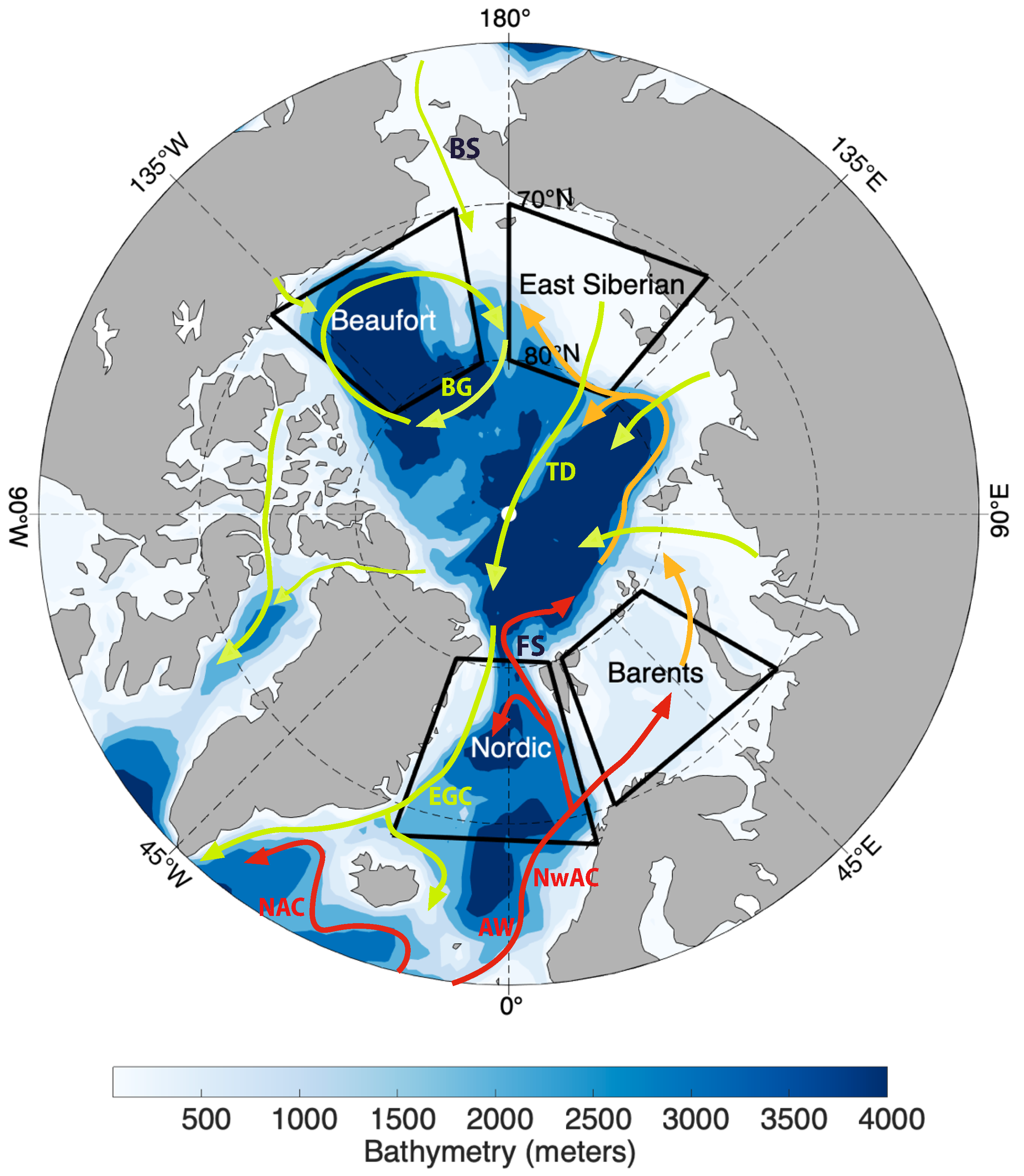
2. Data
2.1. Reanalysis Data
2.2. Remotely Sensed Data
2.3. In-Situ Data
3. Methods
3.1. Surface Quasi-Geostrophic Approach
3.2. Application to Reanalysis Data

3.3. Application to Remotely Sensed SLA Data
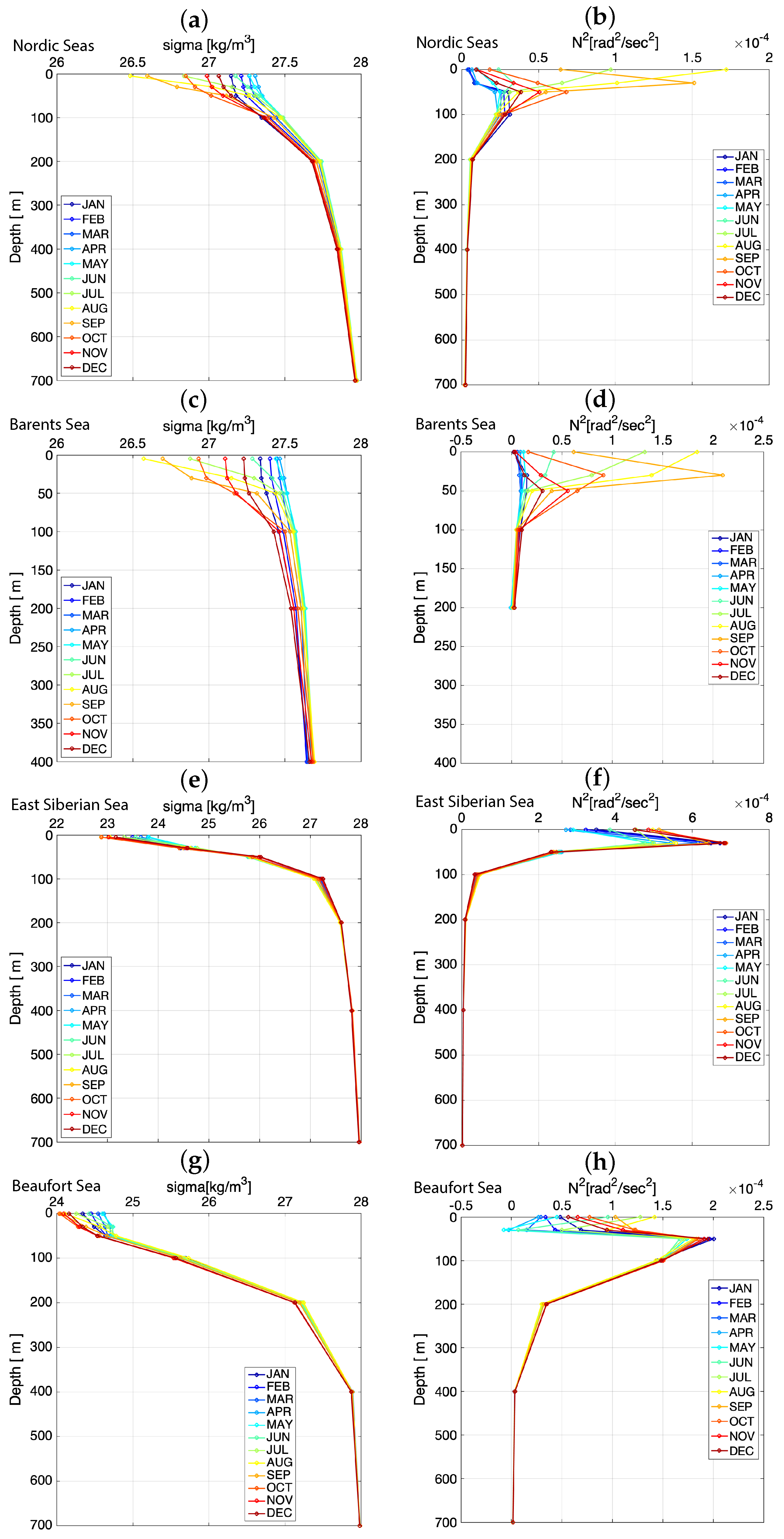
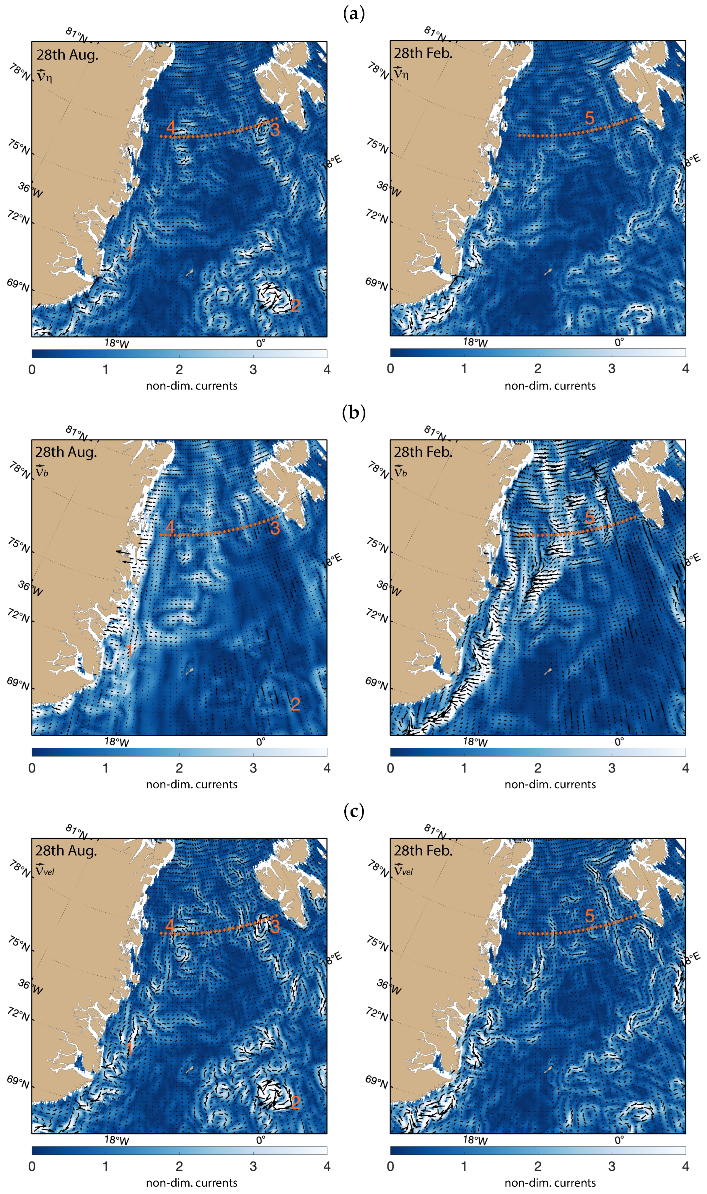
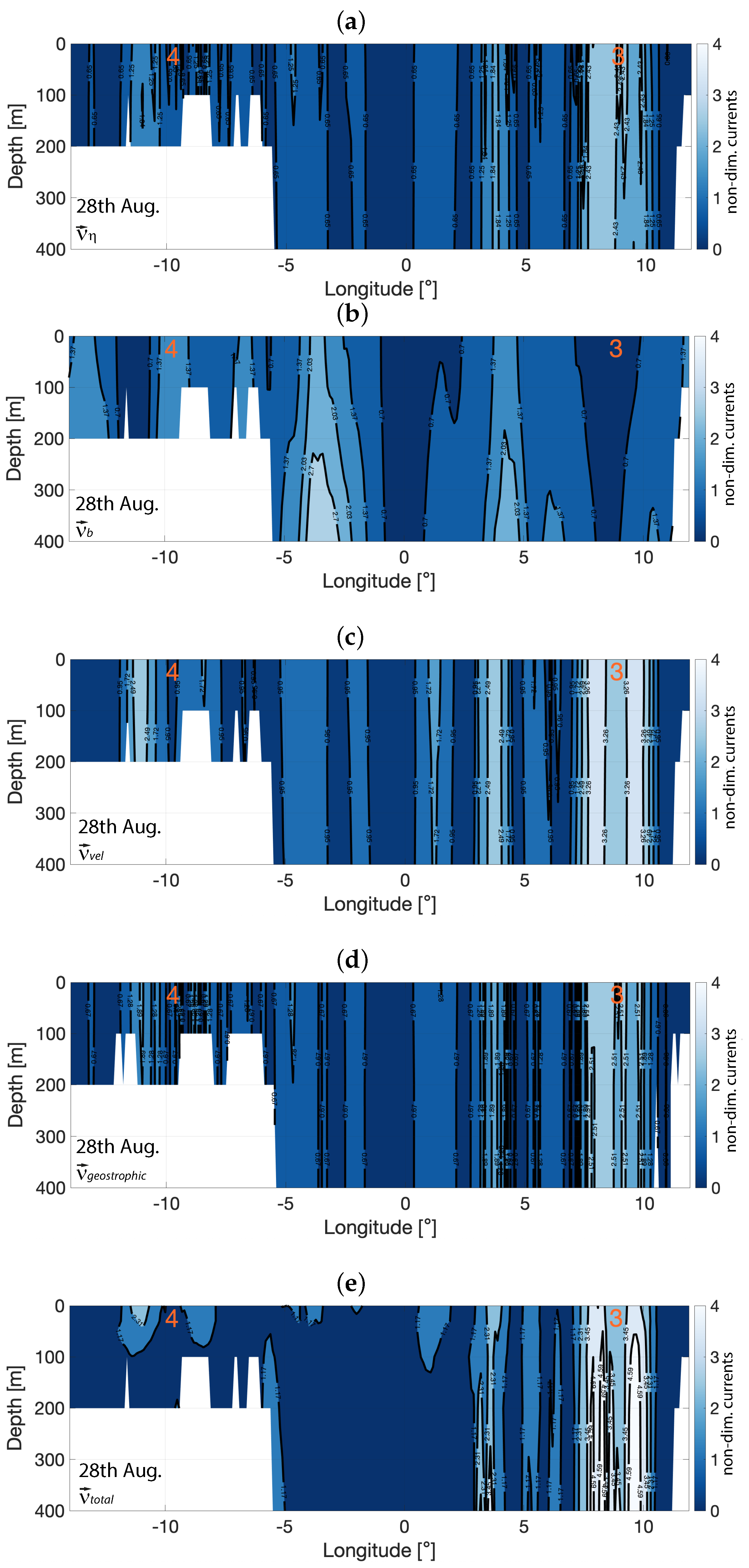
4. Results and Discussion
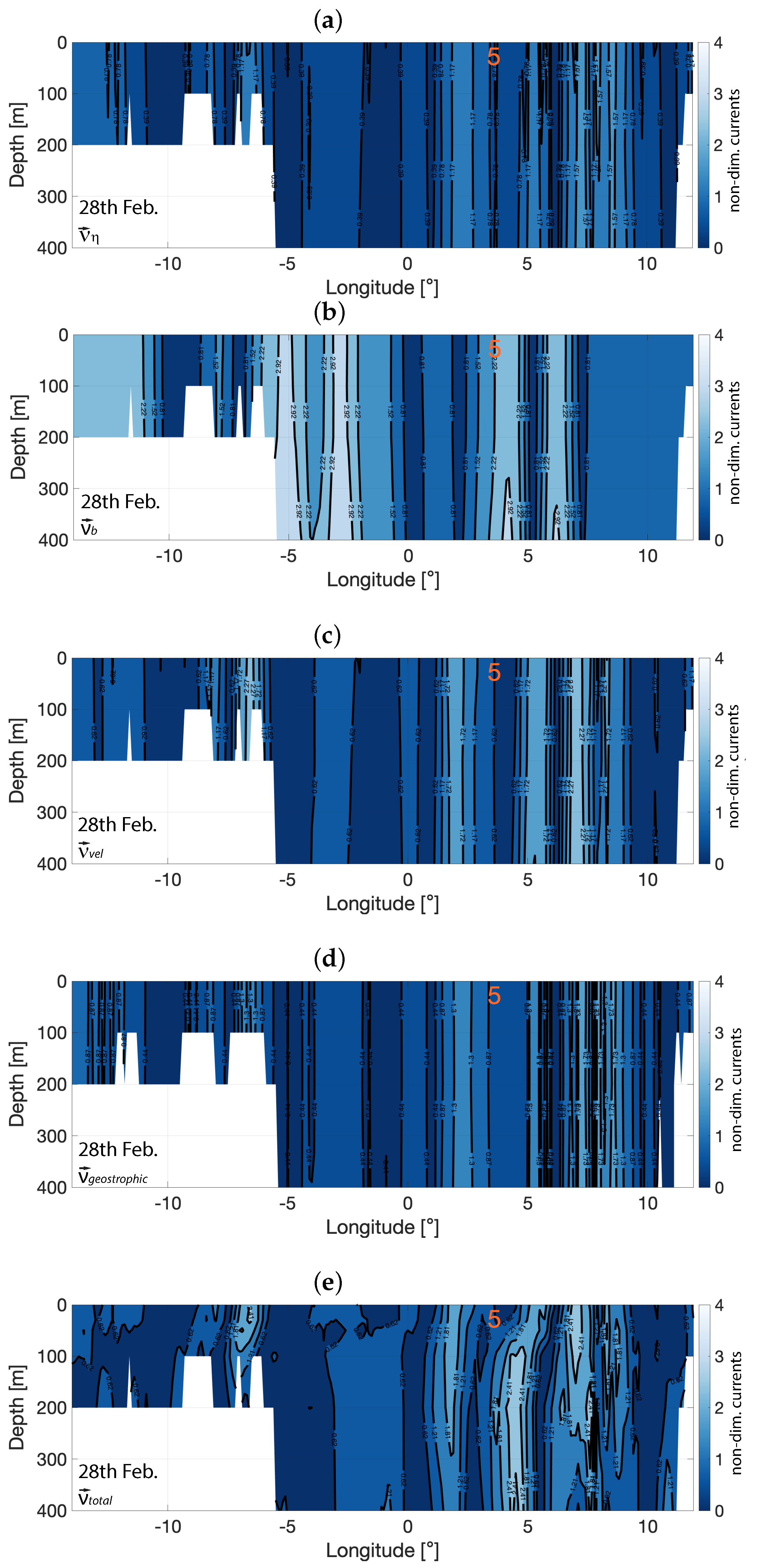
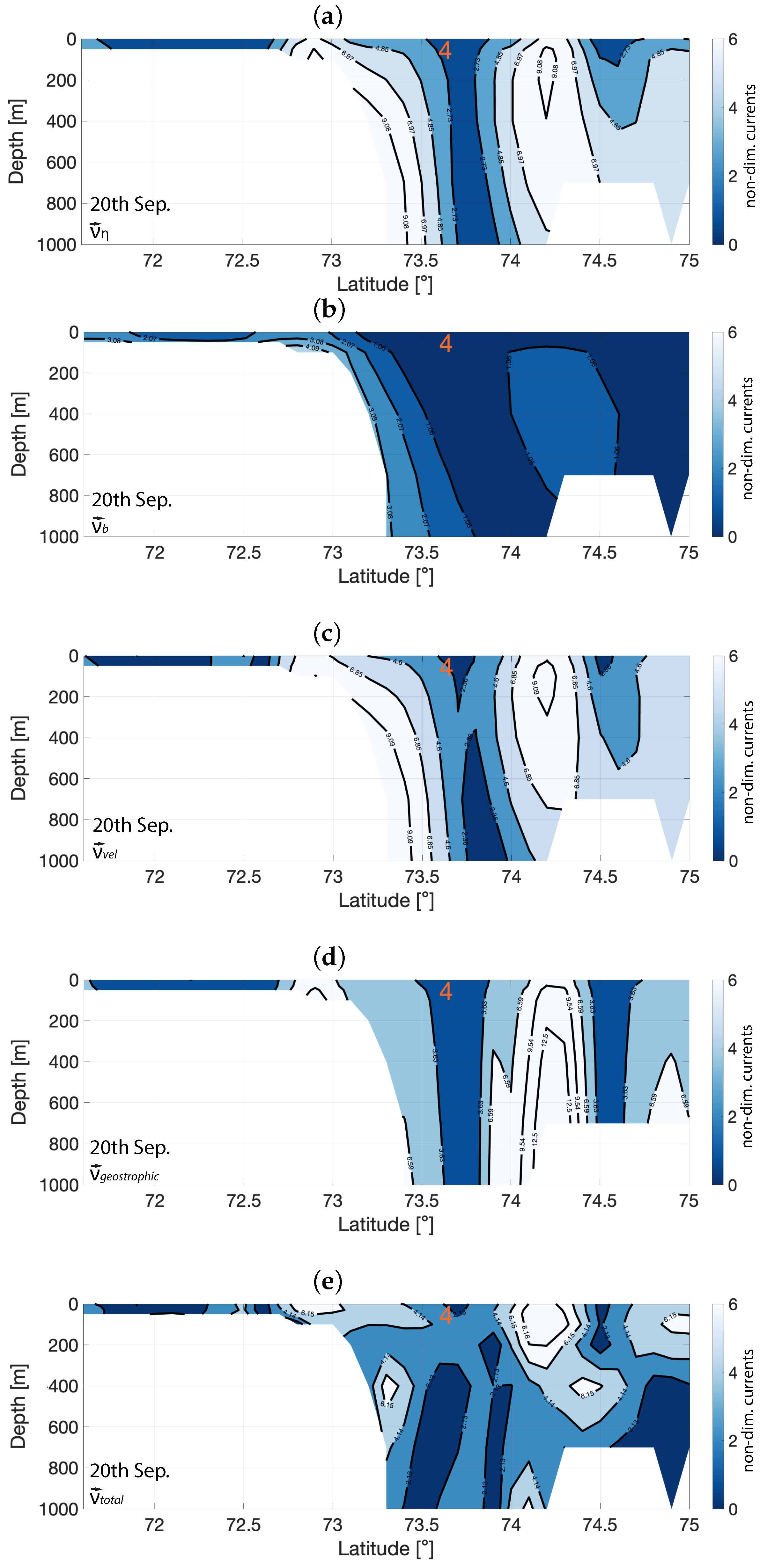
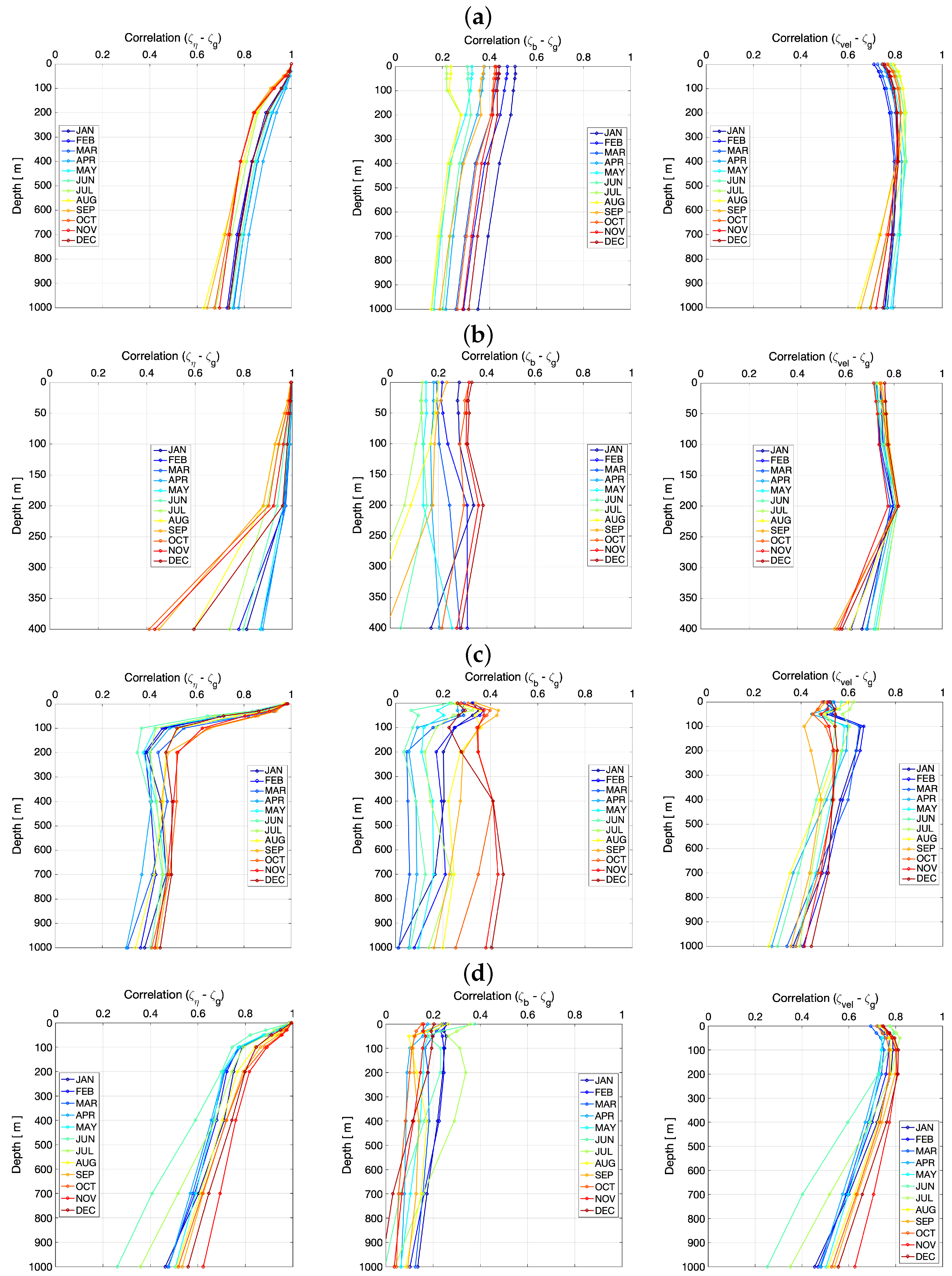
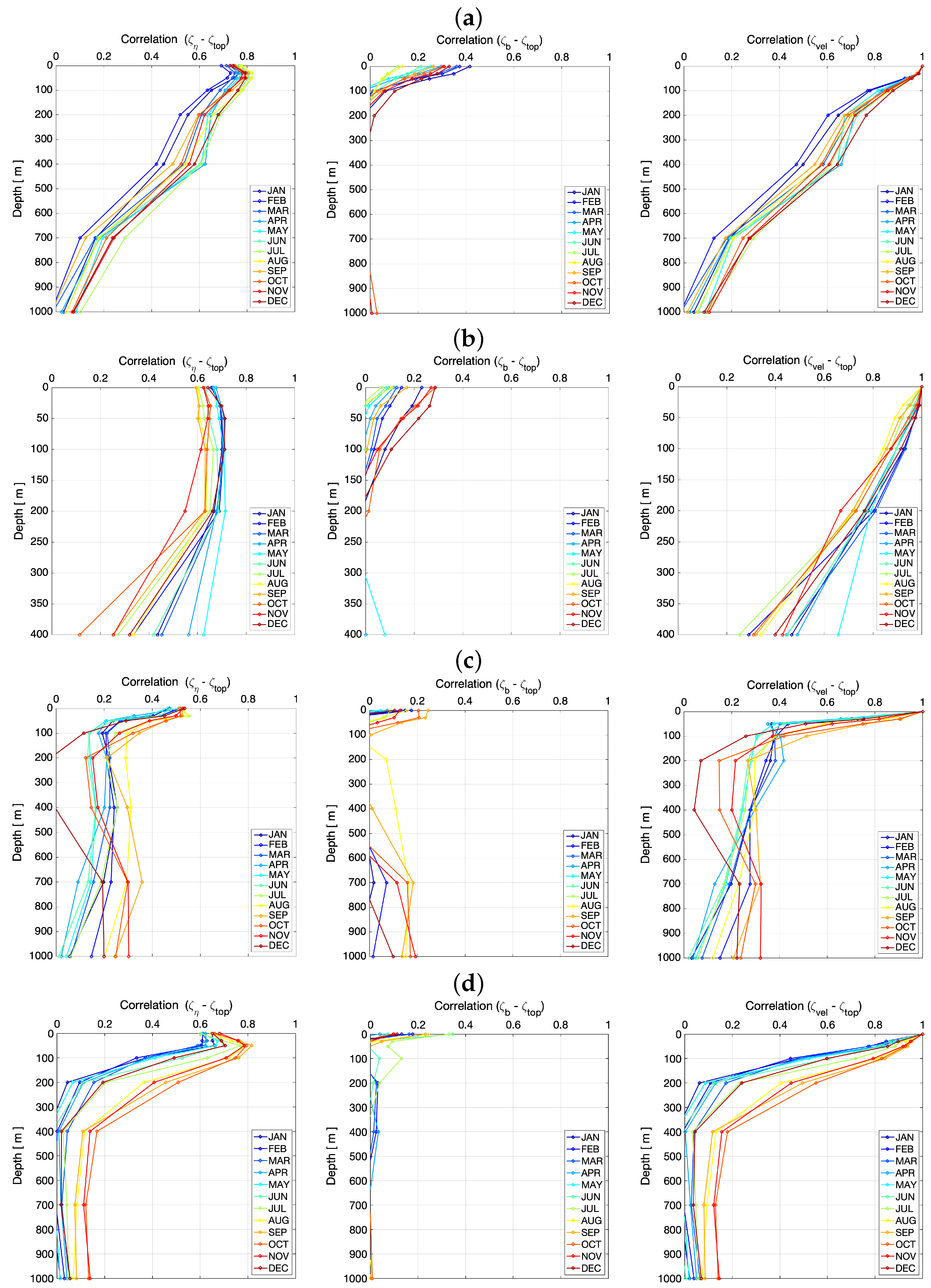
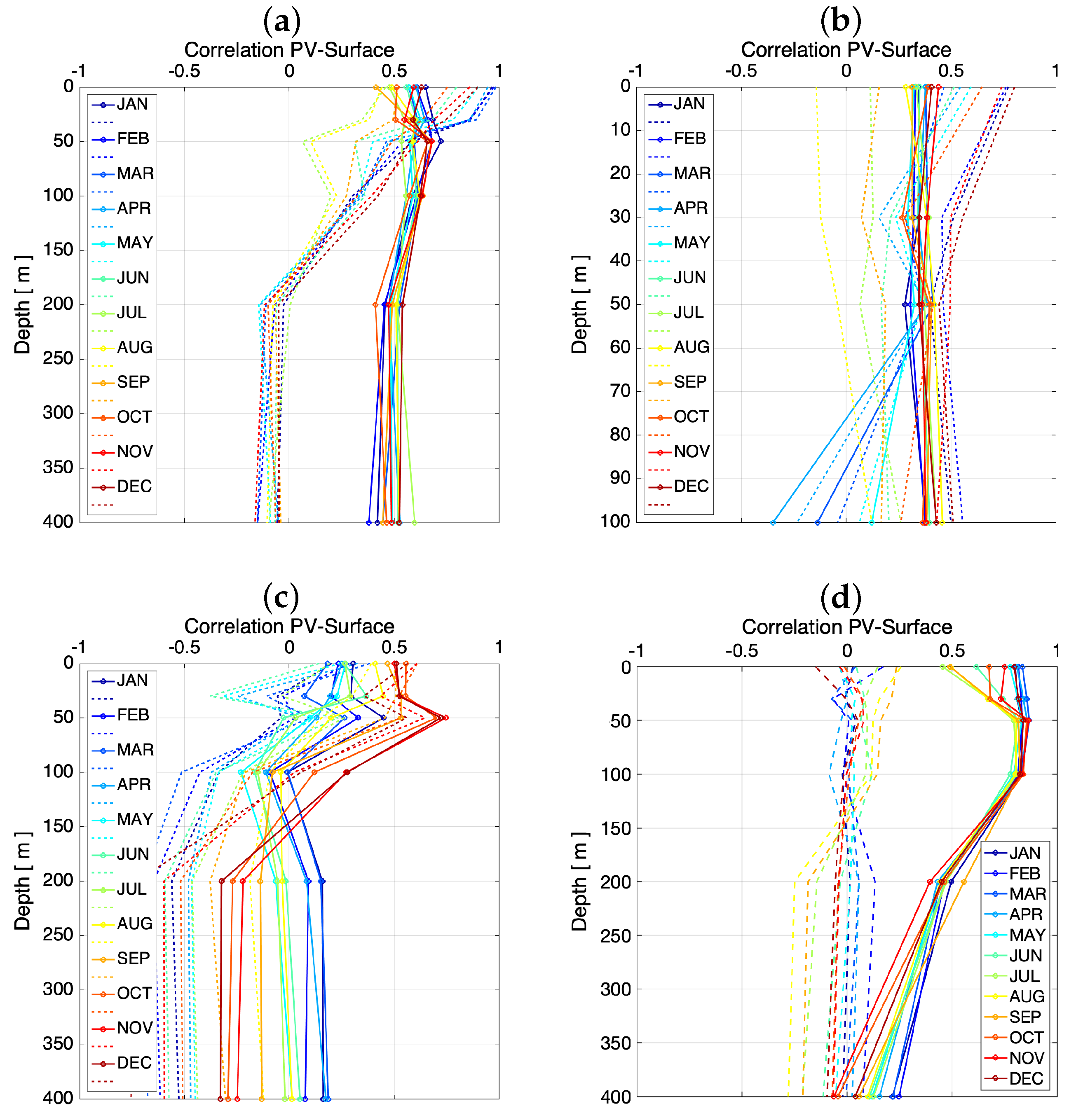
4.1. SQG Assessment Using Reanalysis Data
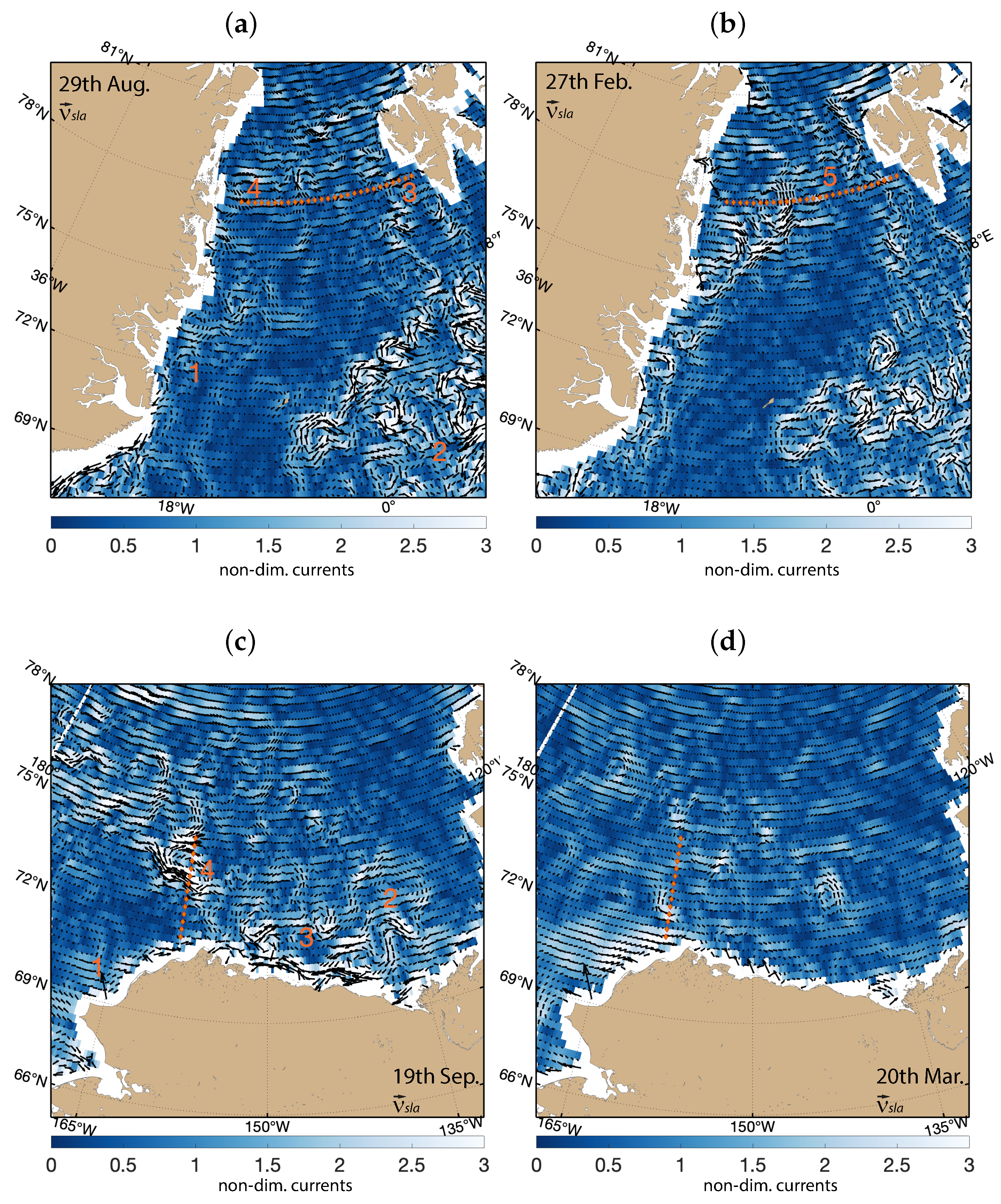
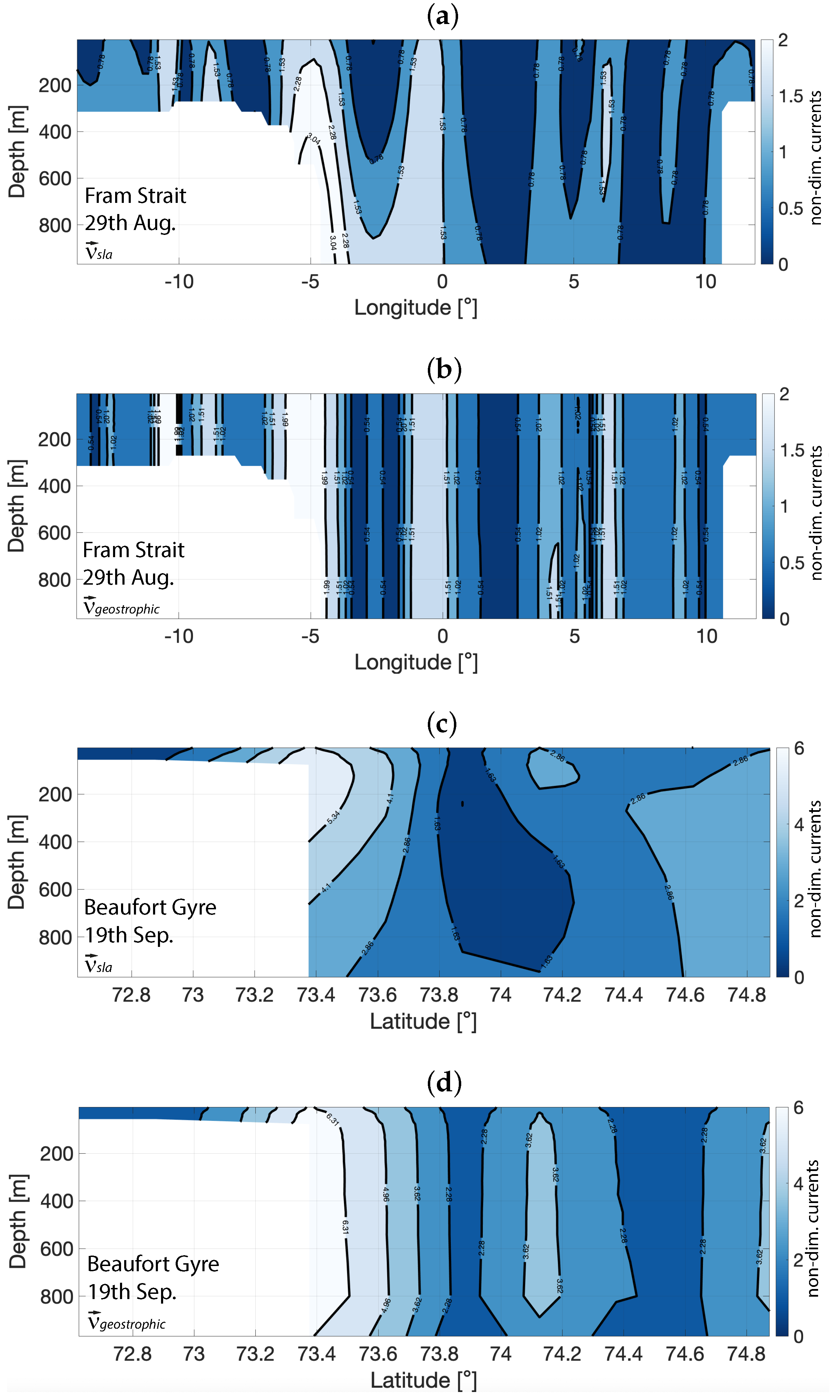
4.2. Reconstruction of 3D Dynamics Using Remotely Sensed Data
5. Conclusions
Author Contributions
Funding
Conflicts of Interest
References
- Morison, J.; Kwok, R.; Peralta-Ferriz, C.; Alkire, M.; Rigor, I.; Andersen, R.; Steele, M. Changing arctic ocean freshwater pathways. Nature 2012, 481, 66–70. [Google Scholar] [CrossRef] [PubMed]
- Haine, T.W.; Curry, B.; Gerdes, R.; Hansen, E.; Karcher, M.; Lee, C.; Rudels, B.; Spreen, G.; de Steur, L.; Stewart, K.D.; et al. Arctic freshwater export: Status, mechanisms, and prospects. Glob. Planet. Chang. 2015, 125, 13–35. [Google Scholar] [CrossRef] [Green Version]
- Morison, J.; Kwok, R.; Dickinson, S.; Andersen, R.; Peralta-Ferriz, C.; Morison, D.; Rigor, I.; Dewey, S.; Guthrie, J. The Cyclonic Mode of Arctic Ocean Circulation. J. Phys. Oceanogr. 2021, 51, 1053–1075. [Google Scholar] [CrossRef]
- Wang, Q.; Danilov, S.; Mu, L.; Sidorenko, D.; Wekerle, C. Lasting impact of winds on Arctic sea ice through the ocean’s memory. Cryosphere 2021, 15, 4703–4725. [Google Scholar] [CrossRef]
- Armitage, T.W.; Manucharyan, G.E.; Petty, A.A.; Kwok, R.; Thompson, A.F. Enhanced eddy activity in the Beaufort Gyre in response to sea ice loss. Nat. Commun. 2020, 11, 761. [Google Scholar] [CrossRef] [Green Version]
- Petty, A.A.; Hutchings, J.K.; Richter-Menge, J.A.; Tschudi, M.A. Sea ice circulation around the Beaufort Gyre: The changing role of wind forcing and the sea ice state. J. Geophys. Res. Ocean. 2016, 121, 3278–3296. [Google Scholar] [CrossRef] [Green Version]
- Campos, C.; Horn, M. The Physical System of the Arctic Ocean and Subarctic Seas in a Changing Climate. In YOUMARES 8–Oceans Across Boundaries: Learning from Each Other; Springer: Cham, Switzerland, 2018; pp. 25–40. [Google Scholar]
- Comiso, J.C. A rapidly declining perennial sea ice cover in the Arctic. Geophys. Res. Lett. 2002, 29, 17-1–17-4. [Google Scholar] [CrossRef] [Green Version]
- Cohen, J.; Screen, J.A.; Furtado, J.C.; Barlow, M.; Whittleston, D.; Coumou, D.; Francis, J.; Dethloff, K.; Entekhabi, D.; Overland, J.; et al. Recent Arctic amplification and extreme mid-latitude weather. Nat. Geosci. 2014, 7, 627–637. [Google Scholar] [CrossRef] [Green Version]
- Timmermans, M.L.; Marshall, J. Understanding Arctic Ocean circulation: A review of ocean dynamics in a changing climate. J. Geophys. Res. Ocean. 2020, 125, e2018JC014378. [Google Scholar] [CrossRef]
- Brakstad, A.; Våge, K.; Håvik, L.; Moore, G. Water mass transformation in the Greenland Sea during the period 1986–2016. J. Phys. Oceanogr. 2019, 49, 121–140. [Google Scholar] [CrossRef]
- Rahmstorf, S. The thermohaline ocean circulation: A system with dangerous thresholds? Clim. Chang. 2000, 46, 247. [Google Scholar] [CrossRef]
- Hansen, B.; Østerhus, S.; Quadfasel, D.; Turrell, W. Already the day after tomorrow? Science 2004, 305, 953–954. [Google Scholar] [CrossRef] [PubMed]
- Blindheim, J.; Osterhus, S. The Nordic Seas, main oceanographic features. Geophys.-Monogr.-Am. Geophys. Union 2005, 158, 11. [Google Scholar]
- Rudels, B.; Björk, G.; Nilsson, J.; Winsor, P.; Lake, I.; Nohr, C. The interaction between waters from the Arctic Ocean and the Nordic Seas north of Fram Strait and along the East Greenland Current: Results from the Arctic Ocean-02 Oden expedition. J. Mar. Syst. 2005, 55, 1–30. [Google Scholar] [CrossRef]
- Shu, Q.; Wang, Q.; Song, Z.; Qiao, F. The poleward enhanced Arctic Ocean cooling machine in a warming climate. Nat. Commun. 2021, 12, 2966. [Google Scholar] [CrossRef]
- Årthun, M.; Eldevik, T.; Smedsrud, L.H. The role of Atlantic heat transport in future Arctic winter sea ice loss. J. Clim. 2019, 32, 3327–3341. [Google Scholar] [CrossRef]
- Anderson, L.G.; Andersson, P.S.; Björk, G.; Peter Jones, E.; Jutterström, S.; Wåhlström, I. Source and formation of the upper halocline of the Arctic Ocean. J. Geophys. Res. Ocean. 2013, 118, 410–421. [Google Scholar] [CrossRef]
- Proshutinsky, A.; Bourke, R.; McLaughlin, F. The role of the Beaufort Gyre in Arctic climate variability: Seasonal to decadal climate scales. Geophys. Res. Lett. 2002, 29, 15-1–15-4. [Google Scholar] [CrossRef] [Green Version]
- Balibrea-Iniesta, F.; Xie, J.; García-Garrido, V.J.; Bertino, L.; Mancho, A.M.; Wiggins, S. Lagrangian transport across the upper arctic waters in the Canada basin. Q. J. R. Meteorol. Soc. 2019, 145, 76–91. [Google Scholar] [CrossRef] [Green Version]
- Pickart, R.S. Shelfbreak circulation in the Alaskan Beaufort Sea: Mean structure and variability. J. Geophys. Res. Ocean. 2004, 109. [Google Scholar] [CrossRef]
- Zhang, J.; Weijer, W.; Steele, M.; Cheng, W.; Verma, T.; Veneziani, M. Labrador Sea freshening linked to Beaufort Gyre freshwater release. Nat. Commun. 2021, 12, 1229. [Google Scholar] [CrossRef] [PubMed]
- Morison, J.; Kwok, R.; Rigor, I. Changes in Arctic Ocean Circulation from In Situ and Remotely Sensed Observations. Oceanography 2022, 35, 57. [Google Scholar] [CrossRef]
- Kelly, S.; Proshutinsky, A.; Popova, E.; Aksenov, Y.; Yool, A. On the origin of water masses in the Beaufort Gyre. J. Geophys. Res. Ocean. 2019, 124, 4696–4709. [Google Scholar] [CrossRef] [Green Version]
- Proshutinsky, A.; Krishfield, R.; Toole, J.; Timmermans, M.L.; Williams, W.; Zimmermann, S.; Yamamoto-Kawai, M.; Armitage, T.; Dukhovskoy, D.; Golubeva, E.; et al. Analysis of the Beaufort Gyre freshwater content in 2003–2018. J. Geophys. Res. Ocean. 2019, 124, 9658–9689. [Google Scholar] [CrossRef] [Green Version]
- Röhrs, J.; Sutherland, G.; Jeans, G.; Bedington, M.; Sperrevik, A.K.; Dagestad, K.F.; Gusdal, Y.; Mauritzen, C.; Dale, A.; LaCasce, J.H. Surface currents in operational oceanography: Key applications, mechanisms, and methods. J. Oper. Oceanogr. 2023, 16, 60–88. [Google Scholar] [CrossRef]
- Reul, N.; Grodsky, S.; Arias, M.; Boutin, J.; Catany, R.; Chapron, B.; d’Amico, F.; Dinnat, E.; Donlon, C.; Fore, A.; et al. Sea surface salinity estimates from spaceborne L-band radiometers: An overview of the first decade of observation (2010–2019). Remote. Sens. Environ. 2020, 242, 111769. [Google Scholar] [CrossRef]
- Martínez, J.; Gabarró, C.; Turiel, A.; González-Gambau, V.; Umbert, M.; Hoareau, N.; González-Haro, C.; Olmedo, E.; Arias, M.; Catany, R.; et al. Improved BEC SMOS Arctic Sea surface salinity product v3. 1. Earth Syst. Sci. Data 2022, 14, 307–323. [Google Scholar] [CrossRef]
- Dohan, K.; Maximenko, N. Monitoring ocean currents with satellite sensors. Oceanography 2010, 23, 94–103. [Google Scholar] [CrossRef] [Green Version]
- Rio, M.H.; Santoleri, R.; Bourdalle-Badie, R.; Griffa, A.; Piterbarg, L.; Taburet, G. Improving the altimeter-derived surface currents using high-resolution sea surface temperature data: A feasability study based on model outputs. J. Atmos. Ocean. Technol. 2016, 33, 2769–2784. [Google Scholar] [CrossRef]
- Chelton, D.B.; DeSzoeke, R.A.; Schlax, M.G.; El Naggar, K.; Siwertz, N. Geographical variability of the first baroclinic Rossby radius of deformation. J. Phys. Oceanogr. 1998, 28, 433–460. [Google Scholar] [CrossRef]
- Nurser, A.; Bacon, S. The rossby radius in the arctic ocean. Ocean. Sci. 2014, 10, 967–975. [Google Scholar] [CrossRef] [Green Version]
- Pascual, A.; Faugere, Y.; Larnicol, G.; LeTraon, P. Improved description of the ocean mesoscale variability by combining four satellite altimeters. Geophys. Res. Lett 2006, 33, 611. [Google Scholar] [CrossRef] [Green Version]
- Ballarotta, M.; Ubelmann, C.; Pujol, M.I.; Taburet, G.; Fournier, F.; Legeais, J.F.; Faugère, Y.; Delepoulle, A.; Chelton, D.; Dibarboure, G.; et al. On the resolutions of ocean altimetry maps. Ocean. Sci. 2019, 15, 1091–1109. [Google Scholar] [CrossRef] [Green Version]
- Pujol, M.I.; Schaeffer, P.; Faugère, Y.; Raynal, M.; Dibarboure, G.; Picot, N. Gauging the improvement of recent mean sea surface models: A new approach for identifying and quantifying their errors. J. Geophys. Res. Ocean. 2018, 123, 5889–5911. [Google Scholar] [CrossRef]
- Armitage, T.W.; Bacon, S.; Ridout, A.L.; Thomas, S.F.; Aksenov, Y.; Wingham, D.J. Arctic sea surface height variability and change from satellite radar altimetry and GRACE, 2003–2014. J. Geophys. Res. Ocean. 2016, 121, 4303–4322. [Google Scholar] [CrossRef] [Green Version]
- Villas Bôas, A.B.; Ardhuin, F.; Ayet, A.; Bourassa, M.A.; Brandt, P.; Chapron, B.; Cornuelle, B.D.; Farrar, J.T.; Fewings, M.R.; Fox-Kemper, B.; et al. Integrated observations of global surface winds, currents, and waves: Requirements and challenges for the next decade. Front. Mar. Sci. 2019, 6, 425. [Google Scholar] [CrossRef]
- Gommenginger, C.; Chapron, B.; Hogg, A.; Buckingham, C.; Fox-Kemper, B.; Eriksson, L.; Soulat, F.; Ubelmann, C.; Ocampo-Torres, F.; Nardelli, B.B.; et al. SEASTAR: A mission to study ocean submesoscale dynamics and small-scale atmosphere-ocean processes in coastal, shelf and polar seas. Front. Mar. Sci. 2019, 6, 457. [Google Scholar] [CrossRef] [Green Version]
- Ciani, D.; Santoleri, R.; Liberti, G.L.; Prigent, C.; Donlon, C.; Buongiorno Nardelli, B. Copernicus Imaging Microwave Radiometer (CIMR) Benefits for the Copernicus Level 4 Sea-Surface Salinity Processing Chain. Remote Sens. 2019, 11, 1818. [Google Scholar] [CrossRef] [Green Version]
- Rodríguez, E.; Bourassa, M.; Chelton, D.; Farrar, J.T.; Long, D.; Perkovic-Martin, D.; Samelson, R. The winds and currents mission concept. Front. Mar. Sci. 2019, 6, 438. [Google Scholar] [CrossRef]
- Chelton, D.B.; Schlax, M.G.; Samelson, R.M.; Farrar, J.T.; Molemaker, M.J.; McWilliams, J.C.; Gula, J. Prospects for future satellite estimation of small-scale variability of ocean surface velocity and vorticity. Prog. Oceanogr. 2019, 173, 256–350. [Google Scholar] [CrossRef]
- Chelton, D.B.; Samelson, R.M.; Farrar, J.T. The Effects of Uncorrelated Measurement Noise on SWOT Estimates of Sea-Surface Height, Velocity and Vorticity. J. Atmos. Ocean. Technol. 2022, 39, 1053–1083. [Google Scholar] [CrossRef]
- Kern, M.; Cullen, R.; Berruti, B.; Bouffard, J.; Casal, T.; Drinkwater, M.R.; Gabriele, A.; Lecuyot, A.; Ludwig, M.; Midthassel, R.; et al. The Copernicus Polar Ice and Snow Topography Altimeter (CRISTAL) high-priority candidate mission. Cryosphere 2020, 14, 2235–2251. [Google Scholar] [CrossRef]
- Buongiorno, B. A Novel Approach for the High-Resolution Interpolation of In Situ Sea Surface Salinity. J. Atmos. Ocean. Technol. 2012, 29, 867–879. [Google Scholar]
- Buongiorno Nardelli, B.; Mulet, S.; Iudicone, D. Three-dimensional ageostrophic motion and water mass subduction in the Southern Ocean. J. Geophys. Res. Ocean. 2018, 123, 1533–1562. [Google Scholar] [CrossRef]
- Lapeyre, G.; Klein, P. Dynamics of the Upper Oceanic Layers in Terms of Surface Quasigeostrophy Theory. J. Phys. Oceanogr. 2006, 36, 165–176. [Google Scholar] [CrossRef]
- LaCasce, J.; Mahadevan, A. Estimating subsurface horizontal and vertical velocities from sea-surface temperature. J. Mar. Res. 2006, 64, 695–721. [Google Scholar] [CrossRef] [Green Version]
- Isern-Fontanet, J.; Shinde, M.; González-Haro, C. On the transfer function between surface fields and the geostrophic stream function in the Mediterranean Sea. J. Phys. Oceanogr. 2014, 44, 1406–1423. [Google Scholar] [CrossRef]
- Isern-Fontanet, J.; García-Ladona, E.; Jiménez-Madrid, J.A.; Olmedo, E.; García-Sotillo, M.; Orfila, A.; Turiel, A. Real-time reconstruction of surface velocities from satellite observations in the Alboran sea. Remote Sens. 2020, 12, 724. [Google Scholar] [CrossRef] [Green Version]
- Isern-Fontanet, J.; García-Ladona, E.; González-Haro, C.; Turiel, A.; Rosell-Fieschi, M.; Company, J.B.; Padial, A. High-Resolution Ocean Currents from Sea Surface Temperature Observations: The Catalan Sea (Western Mediterranean). Remote Sens. 2021, 13, 3635. [Google Scholar] [CrossRef]
- Isern-Fontanet, J.; Chapron, B.; Lapeyre, G.; Klein, P. Potential use of microwave sea surface temperatures for the estimation of ocean currents. Geophys. Res. Lett. 2006, 22, L24608. [Google Scholar] [CrossRef] [Green Version]
- González-Haro, C.; Isern-Fontanet, J. Global ocean current reconstruction from altimetric and microwave SST measurements. J. Geophys. Res. Ocean. 2014, 119, 3378–3391. [Google Scholar] [CrossRef]
- Isern-Fontanet, J.; Olmedo, E.; Turiel, A.; Ballabrera-Poy, J.; García-Ladona, E. Retrieval of eddy dynamics from SMOS sea surface salinity measurements in the Algerian Basin (Mediterranean Sea). Geophys. Res. Lett. 2016, 43, 6427–6434. [Google Scholar] [CrossRef] [Green Version]
- Isern-Fontanet, J.; Lapeyre, G.; Klein, P.; Chapron, B.; Hecht, M.W. Three-dimensional reconstruction of oceanic mesoscale currents from surface information. J. Geophys. Res. Ocean. 2008, 113. [Google Scholar] [CrossRef] [Green Version]
- Miracca-Lage, M.; González-Haro, C.; Napolitano, D.C.; Isern-Fontanet, J.; Polito, P.S. Can the Surface Quasi-Geostrophic (SQG) Theory Explain Upper Ocean Dynamics in the South Atlantic? J. Geophys. Res. Ocean. 2022, 127, e2021JC018001. [Google Scholar] [CrossRef]
- Wang, J.; Flierl, G.R.; LaCasce, J.H.; McClean, J.L.; Mahadevan, A. Reconstructing the ocean’s interior from surface data. J. Phys. Oceanogr. 2013, 43, 1611–1626. [Google Scholar] [CrossRef]
- LaCasce, J.H.; Wang, J. Estimating subsurface velocities from surface fields with idealized stratification. J. Phys. Oceanogr. 2015, 45, 2424–2435. [Google Scholar] [CrossRef] [Green Version]
- de La Lama, M.S.; LaCasce, J.; Fuhr, H.K. The vertical structure of ocean eddies. Dyn. Stat. Clim. Syst. 2016, 1, dzw001. [Google Scholar] [CrossRef] [Green Version]
- Lapeyre, G. Surface quasi-geostrophy. Fluids 2017, 2, 7. [Google Scholar] [CrossRef] [Green Version]
- Lacasce, J.H. The prevalence of oceanic surface modes. Geophys. Res. Lett. 2017, 44, 11–097. [Google Scholar] [CrossRef] [Green Version]
- Klein, P.; Isern-Fontanet, J.; Lapeyre, G.; Roullet, G.; Danioux, E.; Chapron, B.; Le Gentil, S.; Sasaki, H. Diagnosis of vertical velocities in the upper ocean from high resolution sea surface height. Geophys. Res. Lett. 2009, 36, L12603. [Google Scholar] [CrossRef] [Green Version]
- Isern-Fontanet, J.; Hascoët, E. Diagnosis of high-resolution upper ocean dynamics from noisy sea surface temperatures. J. Geophys. Res. Ocean. 2014, 119, 121–132. [Google Scholar] [CrossRef] [Green Version]
- Buongiorno Nardelli, B. A multi-year time series of observation-based 3D horizontal and vertical quasi-geostrophic global ocean currents. Earth Syst. Sci. Data 2020, 12, 1711–1723. [Google Scholar] [CrossRef]
- Stammer, D.; Balmaseda, M.; Heimbach, P.; Köhl, A.; Weaver, A. Ocean data assimilation in support of climate applications: Status and perspectives. Annu. Rev. Mar. Sci. 2016, 8, 491–518. [Google Scholar] [CrossRef] [Green Version]
- Xie, J.; Bertino, L.; Counillon, F.; Lisæter, K.A.; Sakov, P. Quality assessment of the TOPAZ4 reanalysis in the Arctic over the period 1991–2013. Ocean Sci. 2017, 13, 123–144. [Google Scholar] [CrossRef] [Green Version]
- Prandi, P.; Poisson, J.C.; Faugère, Y.; Guillot, A.; Dibarboure, G. Arctic sea surface height maps from multi-altimeter combination. Earth Syst. Sci. Data 2021, 13, 5469–5482. [Google Scholar] [CrossRef]
- Good, S.A.; Martin, M.J.; Rayner, N.A. EN4: Quality controlled ocean temperature and salinity profiles and monthly objective analyses with uncertainty estimates. J. Geophys. Res. Ocean. 2013, 118, 6704–6716. [Google Scholar] [CrossRef]
- Hoskins, B.J.; McIntyre, M.E.; Robertson, A.W. On the use and significance of isentropic potential vorticity maps. Q. J. R. Meteorol. Soc. 1985, 111, 877–946. [Google Scholar] [CrossRef]
- Wright, D.; Pawlowicz, R.; McDougall, T.; Feistel, R.; Marion, G. Absolute Salinity, “Density Salinity” and the Reference-Composition Salinity Scale: Present and future use in the seawater standard TEOS-10. Ocean Sci. 2011, 7, 1–26. [Google Scholar] [CrossRef] [Green Version]
- González-Haro, C.; Isern-Fontanet, J.; Tandeo, P.; Garello, R. Ocean surface currents reconstruction: Spectral characterization of the transfer function between SST and SSH. J. Geophys. Res. Ocean 2020, 125, e2019JC015958. [Google Scholar] [CrossRef]
- Held, I.M.; Pierrehumbert, R.T.; Garner, S.T.; Swanson, K.L. Surface quasi-geostrophic dynamics. J. Fluid Mech. 1995, 282, 1–20. [Google Scholar] [CrossRef]
- Tulloch, R.; Smith, K. A theory for the atmospheric energy spectrum: Depth-limited temperature anomalies at the tropopause. Proc. Natl. Acad. Sci. USA 2006, 103, 14690–14694. [Google Scholar] [CrossRef] [PubMed] [Green Version]
- Vallis, G.K. Atmospheric and Oceanic Fluid Dynamics; Cambridge University Press: Cambridge, UK, 2017. [Google Scholar]
- Wang, Q.; Wekerle, C.; Danilov, S.; Wang, X.; Jung, T. A 4.5 km resolution Arctic Ocean simulation with the global multi-resolution model FESOM 1.4. Geosci. Model Dev. 2018, 11, 1229–1255. [Google Scholar] [CrossRef] [Green Version]
- Stedmon, C.A.; Amon, R.M.; Bauch, D.; Bracher, A.; Gonçalves-Araujo, R.; Hoppmann, M.; Krishfield, R.; Laney, S.; Rabe, B.; Reader, H.; et al. Insights Into Water Mass Origins in the Central Arctic Ocean From In-Situ Dissolved Organic Matter Fluorescence. J. Geophys. Res. Ocean. 2021, 126, e2021JC017407. [Google Scholar] [CrossRef]
- Raj, R.P.; Chafik, L.; Nilsen, J.E.Ø.; Eldevik, T.; Halo, I. The Lofoten vortex of the Nordic seas. Deep. Sea Res. Part I Oceanogr. Res. Pap. 2015, 96, 1–14. [Google Scholar] [CrossRef]
- Richards, C.G.; Straneo, F. Observations of water mass transformation and eddies in the Lofoten Basin of the Nordic Seas. J. Phys. Oceanogr. 2015, 45, 1735–1756. [Google Scholar] [CrossRef] [Green Version]
- Ivanov, V.V.; Korablev, A.A. Formation and regeneration of the pycnocline lens in the Norwegian Sea. Russ. Meteor. Hydrol. 1995, 9, 62–69. [Google Scholar]
- Köhl, A. Generation and stability of a quasi-permanent vortex in the Lofoten Basin. J. Phys. Oceanogr. 2007, 37, 2637–2651. [Google Scholar] [CrossRef]
- Trodahl, M.; Isachsen, P.E.; Lilly, J.M.; Nilsson, J.; Kristensen, N.M. The regeneration of the Lofoten Vortex through vertical alignment. J. Phys. Oceanogr. 2020, 50, 2689–2711. [Google Scholar] [CrossRef]
- Wekerle, C.; Wang, Q.; von Appen, W.J.; Danilov, S.; Schourup-Kristensen, V.; Jung, T. Eddy-resolving simulation of the Atlantic water circulation in the Fram Strait with focus on the seasonal cycle. J. Geophys. Res. Ocean. 2017, 122, 8385–8405. [Google Scholar] [CrossRef]
- Bashmachnikov, I.L.; Kozlov, I.E.; Petrenko, L.A.; Glok, N.I.; Wekerle, C. Eddies in the North Greenland Sea and Fram Strait from satellite altimetry, SAR and high-resolution model data. J. Geophys. Res. Ocean. 2020, 125, e2019JC015832. [Google Scholar] [CrossRef]
- Yuan, M.; Song, Z.; Jing, Z.; Li, Z.; Wu, L. Distinct roles of global cyclonic and anticyclonic eddies in regulating near-inertial internal waves in the ocean interior. Front. Mar. Sci. 2022, 9, 1624. [Google Scholar] [CrossRef]
- Timmermans, M.L.; Toole, J.M. The Arctic Ocean’s Beaufort Gyre. Annu. Rev. Mar. Sci. 2023, 15, 223–248. [Google Scholar] [CrossRef] [PubMed]
- Kubryakov, A.; Kozlov, I.; Manucharyan, G. Large mesoscale eddies in the Western Arctic Ocean from satellite altimetry measurements. J. Geophys. Res. Ocean. 2021, 126, e2020JC016670. [Google Scholar] [CrossRef]
- Rio, M.H.; Mulet, S.; Picot, N. Beyond GOCE for the ocean circulation estimate: Synergetic use of altimetry, gravimetry, and in situ data provides new insight into geostrophic and Ekman currents. Geophys. Res. Lett. 2014, 41, 8918–8925. [Google Scholar] [CrossRef]
- Ciani, D.; Rio, M.H.; Nardelli, B.B.; Etienne, H.; Santoleri, R. Improving the altimeter-derived surface currents using sea surface temperature (SST) data: A sensitivity study to SST products. Remote Sens. 2020, 12, 1601. [Google Scholar] [CrossRef]
- Wunsch, C.; Heimbach, P. Dynamically and kinematically consistent global ocean circulation and ice state estimates. In International Geophysics; Elsevier: Amsterdam, The Netherlands, 2013; Volume 103, pp. 553–579. [Google Scholar]
- Moore, A.M.; Martin, M.J.; Akella, S.; Arango, H.G.; Balmaseda, M.; Bertino, L.; Ciavatta, S.; Cornuelle, B.; Cummings, J.; Frolov, S.; et al. Synthesis of ocean observations using data assimilation for operational, real-time and reanalysis systems: A more complete picture of the state of the ocean. Front. Mar. Sci. 2019, 6, 90. [Google Scholar] [CrossRef] [Green Version]
- Janeković, I.; Rayson, M.; Jones, N.; Watson, P.; Pattiaratchi, C. 4D-Var data assimilation using satellite sea surface temperature to improve the tidally-driven interior ocean dynamics estimates in the Indo-Australian Basin. Ocean Model. 2022, 171, 101969. [Google Scholar] [CrossRef]
- Nardelli, B.B.; Santoleri, R. Methods for the reconstruction of vertical profiles from surface data: Multivariate analyses, residual GEM, and variable temporal signals in the North Pacific Ocean. J. Atmos. Ocean. Technol. 2005, 22, 1762–1781. [Google Scholar] [CrossRef]
- Buongiorno Nardelli, B.; Guinehut, S.; Pascual, A.; Drillet, Y.; Ruiz, S.; Mulet, S. Towards high resolution mapping of 3-D mesoscale dynamics from observations. Ocean Sci. 2012, 8, 885–901. [Google Scholar] [CrossRef] [Green Version]
- Mulet, S.; Rio, M.H.; Mignot, A.; Guinehut, S.; Morrow, R. A new estimate of the global 3D geostrophic ocean circulation based on satellite data and in-situ measurements. Deep. Sea Res. Part II Top. Stud. Oceanogr. 2012, 77, 70–81. [Google Scholar] [CrossRef]
- Umbert, M.; Guimbard, S.; Lagerloef, G.; Thompson, L.; Portabella, M.; Ballabrera-Poy, J.; Turiel, A. Detecting the surface salinity signature of Gulf Stream cold-core rings in Aquarius synergistic products. J. Geophys. Res. Ocean. 2015, 120, 859–874. [Google Scholar] [CrossRef] [Green Version]


| Winter | Spring | Summer | Autumn | Year Mean | |
|---|---|---|---|---|---|
| Nordic Seas | 28.15 | 32.14 | 57.67 | 39.27 | 39.38 |
| Barents Sea | 20.36 | 25.57 | 54.77 | 33.35 | 33.61 |
| East Siberian Sea | 119.20 | 114.57 | 124.89 | 127.19 | 121.50 |
| Beaufort Sea | 69.08 | 63.51 | 83.17 | 80.65 | 74.16 |
| Season | Winter | Spring | Summer | Autumn | Year Mean |
|---|---|---|---|---|---|
| Nordic Seas | 37.47 | 47.69 | 71.51 | 48.97 | 51.36 |
| Barents Sea | 32.98 | 37.95 | 54.52 | 34.47 | 39.92 |
| East Siberian Sea | 119.14 | 114.01 | 145.26 | 131.04 | 127.28 |
| Beaufort Sea | 101.01 | 107.54 | 121.76 | 114.27 | 111.14 |
Disclaimer/Publisher’s Note: The statements, opinions and data contained in all publications are solely those of the individual author(s) and contributor(s) and not of MDPI and/or the editor(s). MDPI and/or the editor(s) disclaim responsibility for any injury to people or property resulting from any ideas, methods, instructions or products referred to in the content. |
© 2023 by the authors. Licensee MDPI, Basel, Switzerland. This article is an open access article distributed under the terms and conditions of the Creative Commons Attribution (CC BY) license (https://creativecommons.org/licenses/by/4.0/).
Share and Cite
Umbert, M.; De-Andrés, E.; Gonçalves-Araujo, R.; Gutiérrez, M.; Raj, R.; Bertino, L.; Gabarró, C.; Isern-Fontanet, J. Surface and Interior Dynamics of Arctic Seas Using Surface Quasi-Geostrophic Approach. Remote Sens. 2023, 15, 1722. https://doi.org/10.3390/rs15071722
Umbert M, De-Andrés E, Gonçalves-Araujo R, Gutiérrez M, Raj R, Bertino L, Gabarró C, Isern-Fontanet J. Surface and Interior Dynamics of Arctic Seas Using Surface Quasi-Geostrophic Approach. Remote Sensing. 2023; 15(7):1722. https://doi.org/10.3390/rs15071722
Chicago/Turabian StyleUmbert, Marta, Eva De-Andrés, Rafael Gonçalves-Araujo, Marina Gutiérrez, Roshin Raj, Laurent Bertino, Carolina Gabarró, and Jordi Isern-Fontanet. 2023. "Surface and Interior Dynamics of Arctic Seas Using Surface Quasi-Geostrophic Approach" Remote Sensing 15, no. 7: 1722. https://doi.org/10.3390/rs15071722