1. Introduction
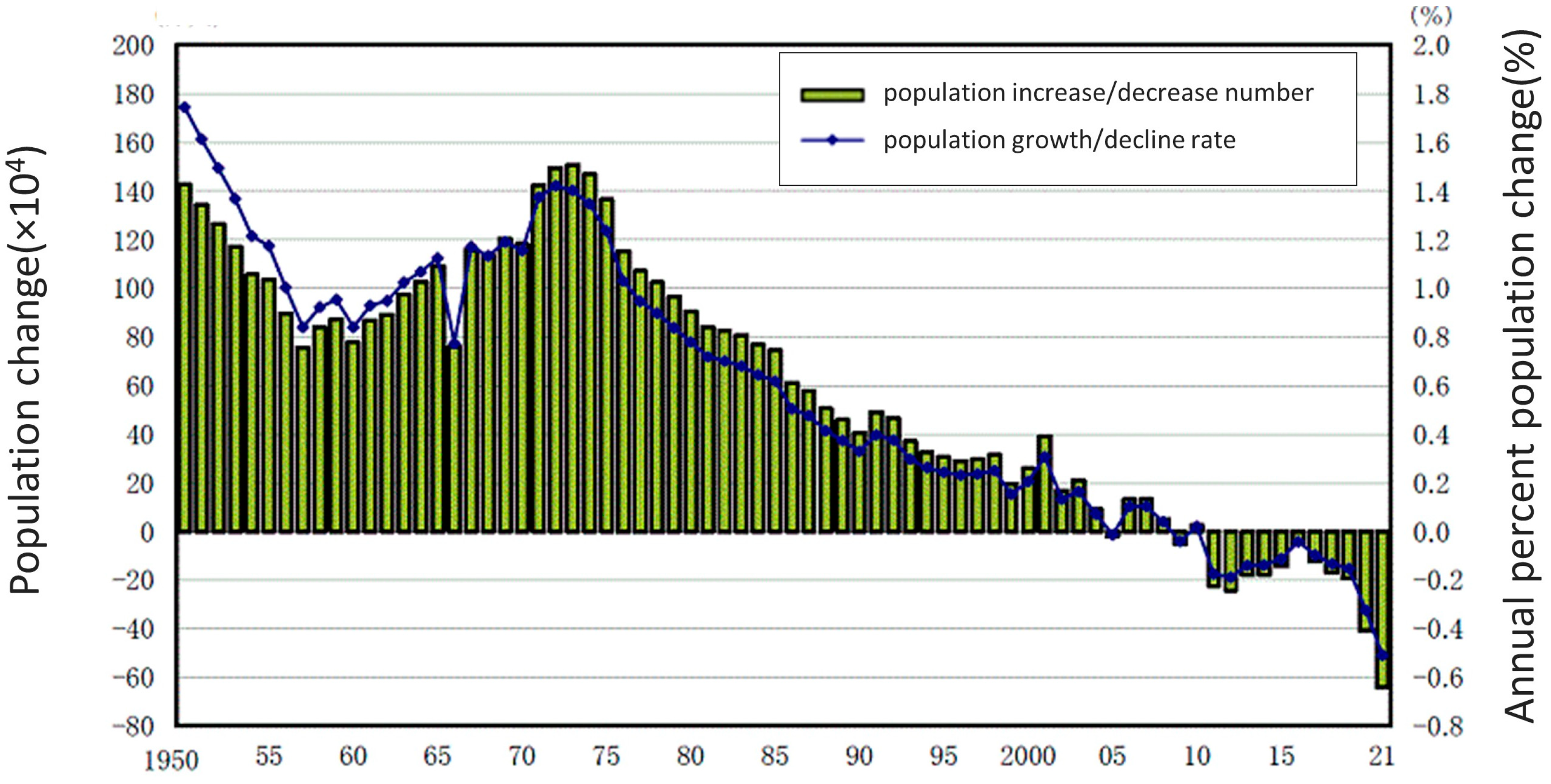
In recent decades, Japan has been grappling with the challenges associated with sustainable regional development, primarily due to depopulation resulting in a declining birth rate and an aging population (
Figure 1) [
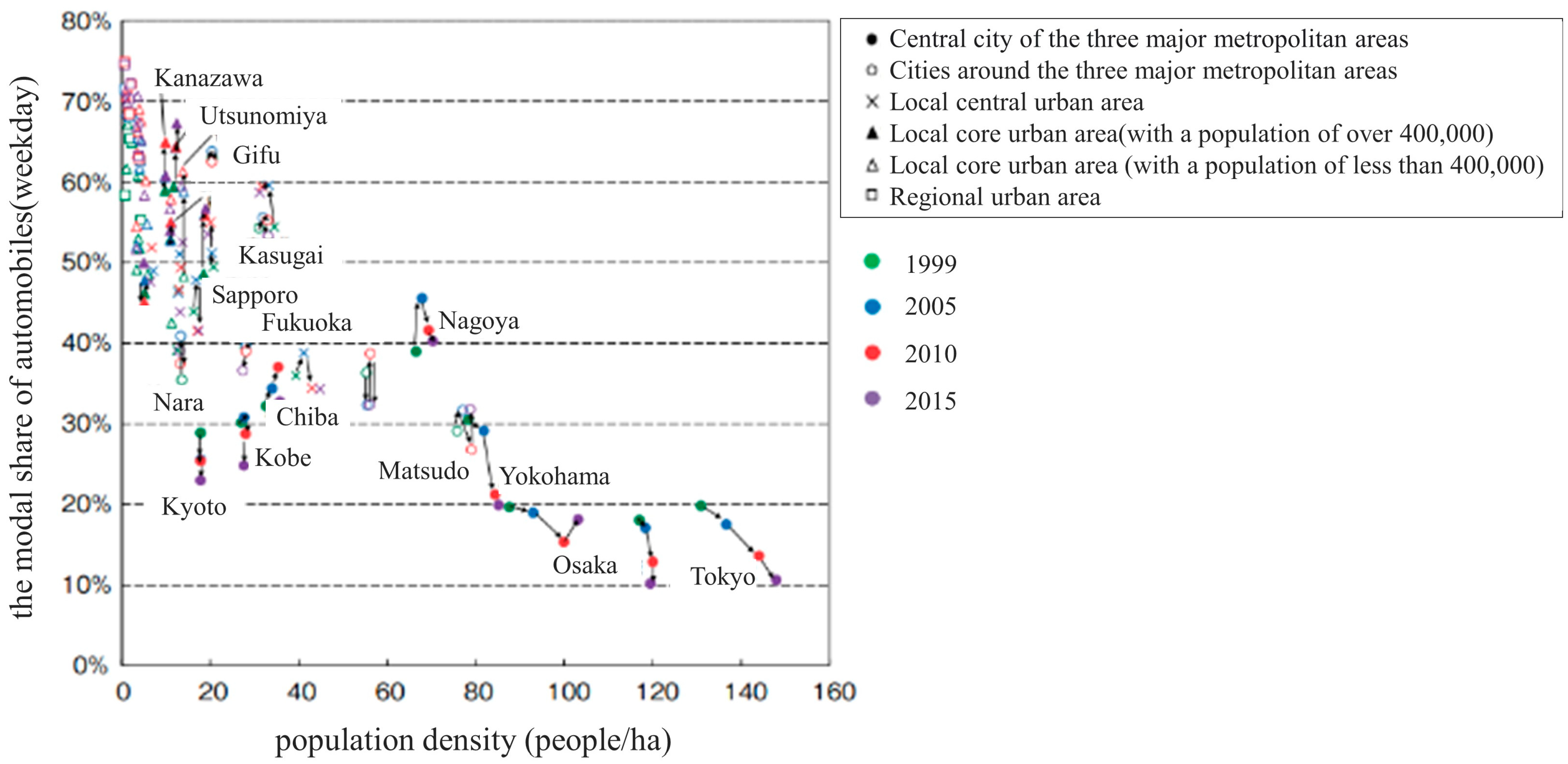
1]. Maintaining a viable population is crucial for ensuring public transportation services. The Ministry of Land, Infrastructure, Transport and Tourism (MLIT) in Japan identified a negative correlation between automobile usage and population density (
Figure 2) [
2]. Against this background, Japan has promoted the Compact Plus Network policy with the goal of improving regional development and public transportation sustainability [
3]. This policy encourages the aggregating of urban facilities and residences while establishing connections between these aggregated facilities and public transportation services.
At the same time, the sustainability of public transportation services, particularly in rural areas, faces increasing challenges. These challenges are driven by factors such as advances in motorized vehicles, a decline in public transportation users, reduced revenue, and a shortage of labor within the transportation industry. Furthermore, the burden on operators to maintain the existing public transportation system has grown heavier due to a decrease in passenger numbers resulting from the COVID-19 epidemic. In an effort to stimulate discussions and propose solutions, railway operators have begun disclosing income and expenditure ratios and other information on unprofitable rail lines [
4]. In response, the Act on Revitalization and Rehabilitation of Local Public Transportation Systems underwent revisions, and the Special Act on the Antimonopoly Law was enacted in Japan, both with the aim of promoting sustainable transportation. These laws urge local governments to take the lead in preserving and improving regional public transportation networks, making the most of their limited resources [
5].
Under these legislative changes, several examples of collaboration between different transportation service operators have emerged. For instance, in the southern part of Tokushima Prefecture, a region experiencing depopulation and a public transportation crisis, a railway company and an express bus company have joined forces to enhance the experience and sustain the services via shared management, offering intermodal transportation services aimed at generating revenue [
6]. In the San-in region, another rural area in Japan, the introduction of a transportation union was proposed in which local governments would be expected to play a role in implementing joint fares, coordinating routes and schedules, and more to achieve a convenient regional transportation service. While such a transportation union has been in place in several European countries for some time, its introduction in Japan, where numerous private transportation operators compete in the transportation market, presents unique challenges. Hence, there is a growing expectation that local governments should take the lead in integrating various public transportation modes.
As mentioned earlier, the coordination between different transportation modes is being encouraged to enhance user convenience. Nonetheless, there remains a lack of indicators to assess this coordination, the connectivity, and the range of transportation modes within a public transportation network. Furthermore, the impact of this coordination on sustainable regional development and public transportation systems has not been thoroughly examined. This study aims to bridge the existing gaps in the literature and offer practical applications by developing an index for evaluating the public transportation system from the perspective of transportation diversity and further considering the connectivity among the services. With a focus on northern Osaka prefecture as the study area, the developed index will be employed to analyze the correlation between transportation diversity in this region and various economic and societal indicators. This study attempts to provide insights for the improved establishment of a seamless and efficient transportation system that fosters sustainable transportation and regional development.
2. Literature Review
2.1. Studies on Sustainable Public Transportation Systems
The relationship between sustainable transportation and sustainable community development has been highlighted in several studies. Banister [
7] emphasized the need for flexible considerations within existing principles to achieve sustainable transportation. The study also underscored the necessity of policies for sustainable transportation to enhance and attain urban sustainability. Similarly, Jabareen [
8] noted that sustainable transportation is an integral part of design concepts related to sustainable urban form, emphasizing the importance of a sustainable transportation system for regional sustainability.
Building on these perspectives, numerous studies have explored evaluation methods for sustainable transportation. Jeon et al. [
9] conducted a review in North America, Europe, and Oceania, examining the components of sustainable transportation and evaluation methods. Tang et al. [
10] analyzed and discussed railways in Hong Kong, highlighting the significance of long-term transportation policy planning for mass transit rail projects. Litman et al. [
11] mentioned that preferred solutions for sustainable transportation can vary depending on the definition of sustainable transportation, suggesting that changing the way people think about and address transportation problems is essential in realizing sustainable planning. Goldman et al. [
12] suggested that sustainable transportation could be achieved via various innovative developments within the transportation sector, indicating a substantial focus on achieving sustainable transportation. However, these studies did not delve into the relationship between the diversity within a public transportation system and regional and transportation sustainability.
In the context of sustainable transportation in societies with declining populations, Kii et al. [
13] made a trial to examine sustainable urban transportation strategies under such conditions, employing a vision-led decision-making approach. However, the study oversimplified public transportation by attempting to cover a broad range of areas and lacked a comprehensive understanding of the diverse functionalities of various transportation modes. Sutradhar et al. [
14] tried to address transportation issues in depopulated areas, emphasizing the importance of tailoring solutions to local conditions, but similarly, few suggestions were provided from the perspective of diversity.
2.2. Studies on Diversity of Public Transportation
Diversity in public transportation has also been examined from various perspectives. For example, Watanabe et al. [
15] emphasized the significance of service coordination among multiple transportation modes to improve the efficiency of intercity networks. Hasegawa et al. [
16] assessed the cost required to achieve a certain level of service for each transportation mode based on travel demand and distance traveled by users. Despite various approaches to transportation diversity, there is a lack of quantitative methods for assessing diversity levels.
In terms of quantitative methods, there are several definitions of the concept of transportation diversity. Litman [
17] defined transportation diversity as the variety of mobility options available in a particular situation. Fujiwara et al. [
18] defined the diversity index as “the degree to which there is a mix of people who use public transportation at various frequencies” and calculated it using the provided index. Feng et al. [
19] defined transportation diversity as the extent to which stakeholders’ needs are met. As demonstrated, there have been various interpretations of diversity in public transportation. As an example of diversity quantitation, Ren et al. [
20] conducted a case study in Hartford, Connecticut, in an attempt to develop a quantitative method for evaluating diverse transportation in terms of both physical infrastructure and travel behavior. In the field of urban planning, Li et al. (2023) used Shannon’s Diversity Index as one of the indicators to assess landscape patterns [
21]. Nakase et al. [
22], Rahimi-Golkhandan et al. [
23], and Hatoko [
24] also linked the concept of ecological diversity with assessing diversity in transportation. Given the similarities between the current study and Nakase et al.’s work [
22] in the context of depopulation, this study draws inspiration from that study and aims to develop a higher spatial resolution method for assessing the diversity of public transportation.
2.3. Quantification of Hierarchical Diversity of Public Transportation
Nakase et al. [
22] defined a diversity index incorporating information on transportation classification by considering public transportation as an analogy of a hierarchical structural system. They set up the diversity index of public transport modes, named Diptm as
where S is the total modes of public transport present in the city and x and w
ij indicate the taxonomic distances between modes x and j in the hierarchical classification.
Taxonomic distance is an indicator defined based on the hierarchical structure, which classifies public transportation according to its functional role. Spatial and temporal coverage is an indicator viewed as the number of individuals suggested by the ecological diversity index and is determined according to the length of routes, the presence or absence of stations, and the service frequencies.
In their study, transportation diversity was calculated for each city and urban employment area. The relationship between the diversity index and the sustainability of the transportation system was also highlighted by analyzing its correlation with population and the modal share of public transportation services. Despite the proposed quantitative transport diversity index, the previous study also has some limitations. Initially, since diversity was calculated based on the presence or absence of each transportation mode within a spatial unit, the connection between modes was not considered in the previous study. Additionally, because the unit of analysis is spatially large and dependent on administrative districts, it cannot verify the effects of public transportation routes, stations, stops, and the population at the neighborhood level.
To address these limitations, this study aims to enhance the spatial resolution of the analysis unit and reconstruct a public transportation diversity index. This effort bridges a current research gap by considering connectivity within the public transportation network.
3. Materials and Methods
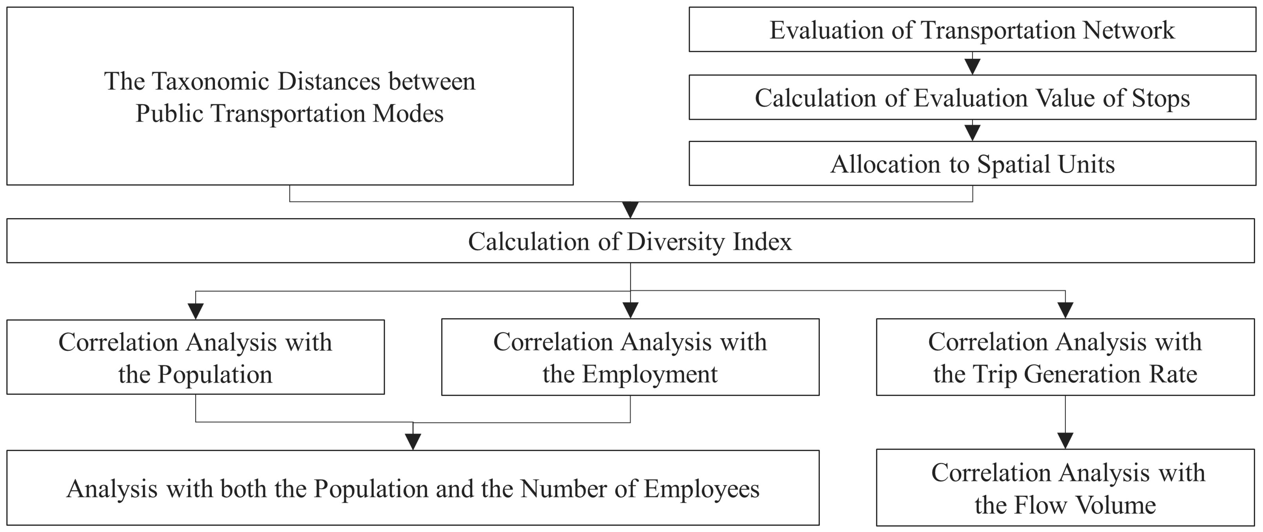
Figure 3 shows the concrete analytical framework of this study. First, the transportation diversity index will be adapted by taking service connectivity into account, and the diversity index will be calculated for each spatial unit. Next, correlation analyses will be conducted between the diversity index and various indicators regarding population, employment, and trip generation rate. Specifically, the employed indicators include population, the number of enterprises, the number of employees, the trip generation rate, and the trip distribution rate. Here, the population of Japan MESH 3, trip generation data, and trip distribution data were based on digital national land information by the Ministry of Land, Infrastructure, Transport and Tourism. In addition, the population of the small zone was based on the 2010 Population Census conducted by the Japanese Statistics Bureau (JSB). Also, economic indicators are based on the 2012 Economic Census of Activity results conducted by the Japanese Statistics Bureau (JSB).
3.1. Study Area and Spatial Resolution of This Study
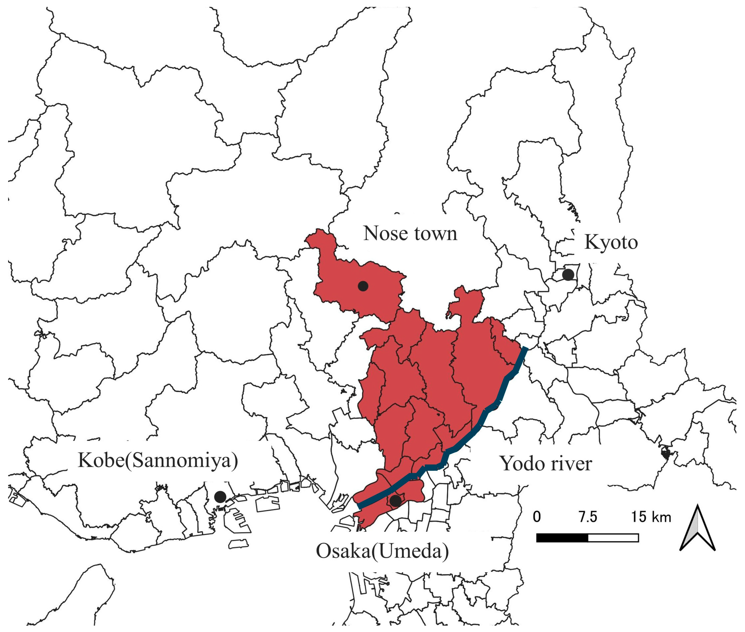
The study area is located in northern Osaka Prefecture, Japan, from the northern edge of Osaka Prefecture (i.e., Nose town) to the north of Yodo River (
Figure 4). It covers the area with various demographic and geographic features, including rural towns, suburban and urban cities, including an important commercial center of Japan—Umeda. The study area site lies within the Kyoto–Osaka–Kobe (also called Keihanshin) metropolitan region, the second largest urban and industrial agglomeration in Japan after Tokyo. However, some edge cities in this area are experiencing rapid rural depopulation due to a decreasing population and rural out-migration.
The area has an integrated transportation network with multimodal transport services. The Japan Railway (JR) and various private companies provide intercity and intracity rail services. There are also many bus services, including highway, municipal, and on-demand buses. One airport in this area offers additional options for long-distance intercity transport. In addition to the current services, ongoing projects are planning to build new rail lines into the suburban areas on the northern edge of Osaka. As shown above, the city is trying to realize a more diverse and sustainable transport system.
This study employed two spatial units: the Japan MESH3 and small zones. The Japan MESH3, known as the “Basic Grid Square”, is an official definition recommended by the Japanese government, where each mesh has a width and height of approximately 1 km. The small zone presents the smallest spatial unit used in the person trip survey to investigate traffic flow.
3.2. Parameters to Assess Connectivity of Public Transportation
This study adopted the Space Syntax (SS) theory to assess connectivity within a multimodal transportation network. SS theory, as affirmed by Hiller et al. [
25,
26], offers a method for quantifying the connectivity of street spaces, providing a graphical representation of spaces at a human scale. In this study, the scope of the theory is expanded to encompass public transportation, and the public transportation network is configured with nodes representing public transportation stations and links signifying the routes of public transportation or walking trips. Furthermore, the assessment is conducted from the user’s perspective by quantifying time and psychological resistance.
The data associated with the location of public transportation stations was sourced from the digital national land information (MLIT, Tokyo, Japan). Information regarding bus routes and their service levels (e.g., timetables) was acquired from the same digital national land information source, while train information was extracted from the timetables provided by service providers. In addition to capturing spatial and temporal service information, this study takes transfer resistance into consideration when assessing the connectivity of public transportation from the user’s perspective. Vertical transfer distances are assumed based on the floor information for buses, set on the first floor, and are for rail transportation, derived from station floor maps. To perform a realistic assessment, the links are weighted based on three factors: travel time, waiting time, and time conversion of resistance due to transfers.
Travel time for public transportation and walking were calculated depending on the linear distance between the origin–destination (OD) and the speed of each mode (
Table 1).
The waiting time for walking is set to 0 min, and the time waiting for the public transportation service is set as follows.
The waiting time for the first public transport trip in a trip chain is set according to Kobayashi et al. [
27] as
where t
w is the waiting time for the first public transport and t
n is headway. The headway of the service was extracted from the timetable. The waiting time for transferring between public transportation services is calculated as the expected value, which is half of the headway of the mode to which the passenger transferred.
In general, the time waiting for the next vehicle (e.g., train or bus) and the distance to walk between stations result in passengers’ psychological resistance to transfer. In this study, this resistance is considered in two categories as follows: the resistance to the behavior of switching from the original mode and moving to the next service. Concerning the former resistance, the uncertainty of travel time often deters people from transferring between modes, with bus services typically considered to have higher uncertainty in travel time compared to railways [
28]. As a result, transfer resistance can vary depending on the travel mode. According to Nakamura and Morimoto [
28],
Table 2 shows the time equivalent of such resistance. Higher values indicate increased resistance to transferring to a particular mode, resulting in higher travel costs.
In terms of the resistance to moving between different modes, psychological resistance is expected to be greater in a transit station, where people travel on foot for transfers.
Table 3 presents the equivalent time coefficients related to moving between services, as provided by the National Institute for Land and Infrastructure Management [
29]. These coefficients are designed to quantify the burden associated with movement compared to standing for waiting, with standing for waiting without moving set as the reference value of 1.0. The quantified resistance varies depending on whether the transfer is completed horizontally or vertically (i.e., moving upstairs or downstairs). A higher value indicates increased resistance to walking for transfer, thereby contributing to higher travel costs.
3.3. Evaluation of Transportation Network
Based on the proposed parameters, this study formulates equations and estimates the performance of each node (i.e., station) in the network. Since the measured spatial units in this study are small, it is rare for more than one mode to exist within each unit. Therefore, the formulation should favor interpreting the centrality of a node in the network of nodes (e.g., a transportation hub is expected to have the role of a central node within the network), as well as the connectivity between nodes.
In this formulation, the total travel cost between two points, including travel time, waiting time, and transfer resistance, is uniquely estimated in terms of time value for each OD pair corresponding to a link in the network. When multiple route choices exist for an OD pair, the route with the smallest cost is assigned. Initially, only public transportation options were considered for assigning routes for each OD for the first trip. The travel cost per OD is denoted as D
uv, where u presents the origin node, and v presents the destination node. It is then used to calculate the average cost for each starting point using the following equation:
where N is the set of the node and k is the number of the node.
Using these indices to quantify centrality and connectivity, we formulated two equations as follows:
where α is the public transportation mode available in the node u, and β presents another public transportation mode. Equation (5) proposes the relative centrality index Rc, quantifying the centrality of a node from the perspective of convenience. On the other hand, Equation (6) proposes the connectivity index Co.
The performance of each node is decided by travel cost. As elaborated in
Section 3.2, travel time is determined by the speed of each mode. In addition, transfer resistance is estimated based on both uncertainty in travel time and types of movement for transfer. Thus, within the network, nodes with routes involving transfers between buses or moving upstairs within a transit station will be assigned a higher time cost, consequently resulting in lower performance of Rc and Co.
3.4. Allocation to Spatial Units
Based on the estimated results for each node, the estimated value for each spatial unit is obtained. A mesh grid is set at a 100 × 100 m square. The center of each mesh is verified to be within the service area of each stop. The distance between the mesh center and the node was calculated. The service area for bus stops and rail stations are, respectively, set to 500 m and 1 km from the node.
The estimated results for each mesh are derived from the values of the nodes, taking the service area into account. Accordingly, Rc (i.e., centrality index) is employed to assess transport modes at each node, while the Co (i.e., connectivity index) is used to assess transport modes at stations serving passengers’ destinations.
3.5. Calculation of Diversity Index
Referring to the previous study by Nakase et al. [
22] The diversity index (DI) in this study is defined as follows:
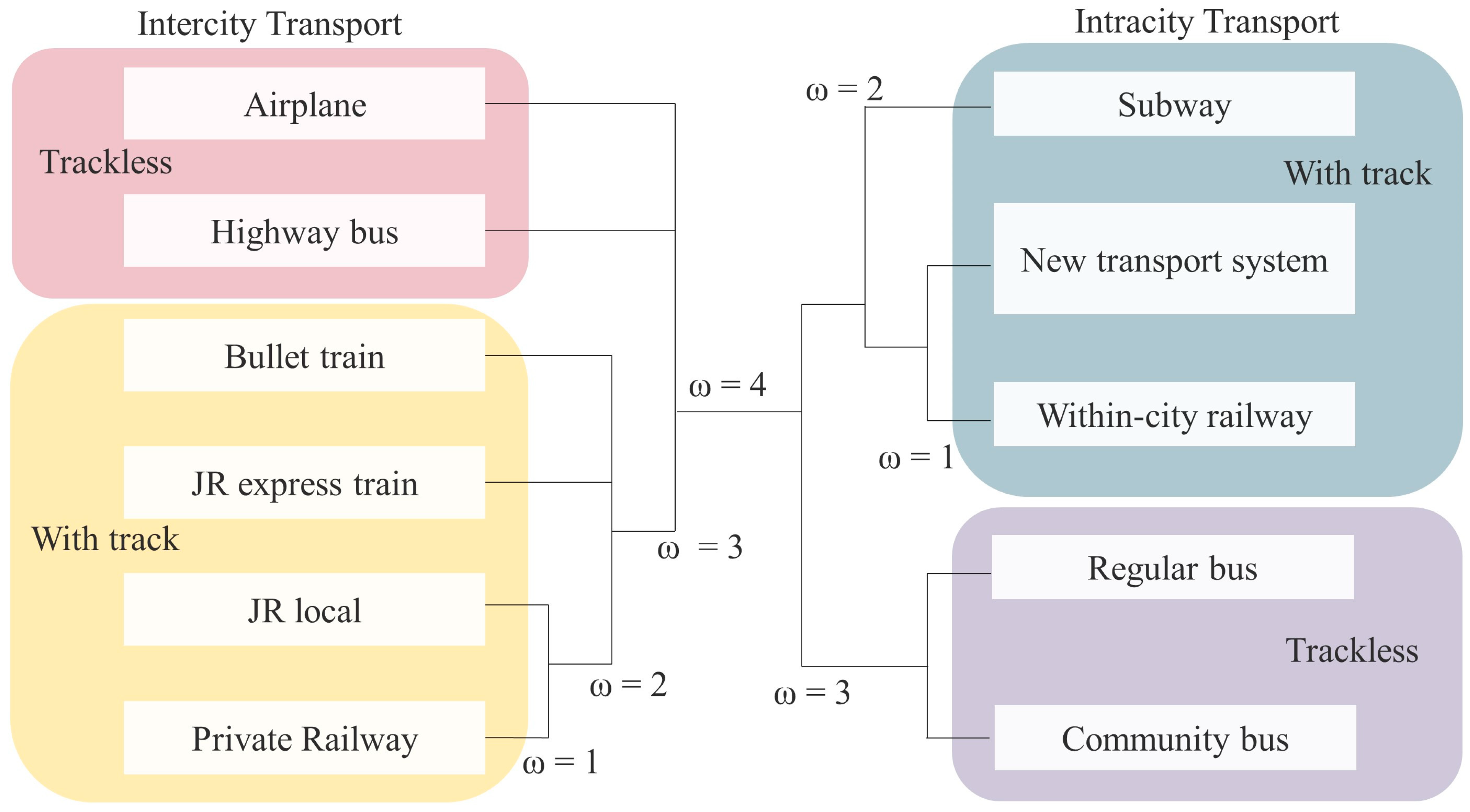
where M is the set of traffic modes, α and β are any transportation mode, ω
αβ indicates the taxonomic distances between modes α and β in the hierarchical classification, and i is the spatial unit. The taxonomic distance is referred to in the previous study and was modified to adapt to the study area of this study (
Figure 5).
4. Results
4.1. Correlation Analysis with the Population
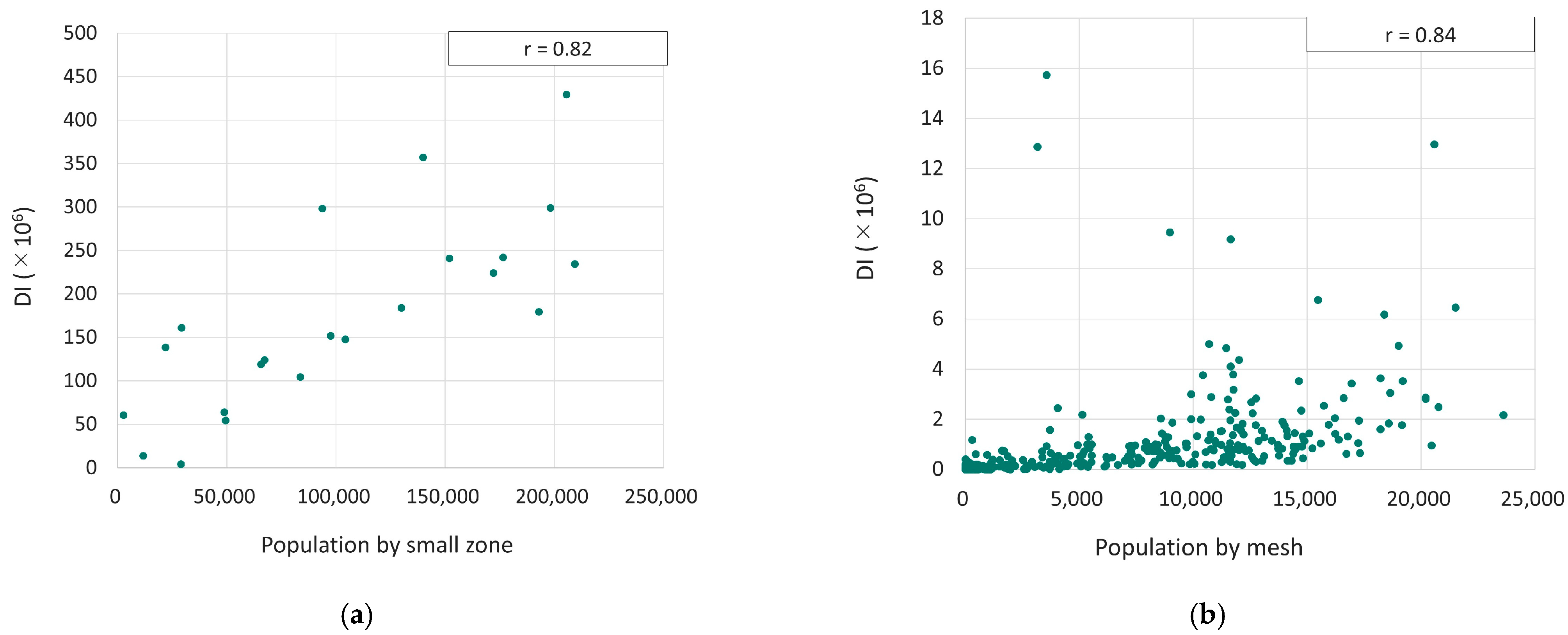
Correlation analysis was first conducted between DI and the population (
Figure 6). Spearman’s correlations showed a significant positive relationship between DI and the population based on Japan MESH3, the officially suggested basic grid square, with a correlation coefficient (r) of 0.84. Similarly, a strong positive relationship was observed between the population of small zones and DI (r = 0.82). For areas with a DI value exceeding 4 million, a smaller coefficient was found between Japan’s MESH3 population and diversity value. These areas are characterized by high commercial activities. Further analysis will be conducted for these areas and presented in
Section 4.3.
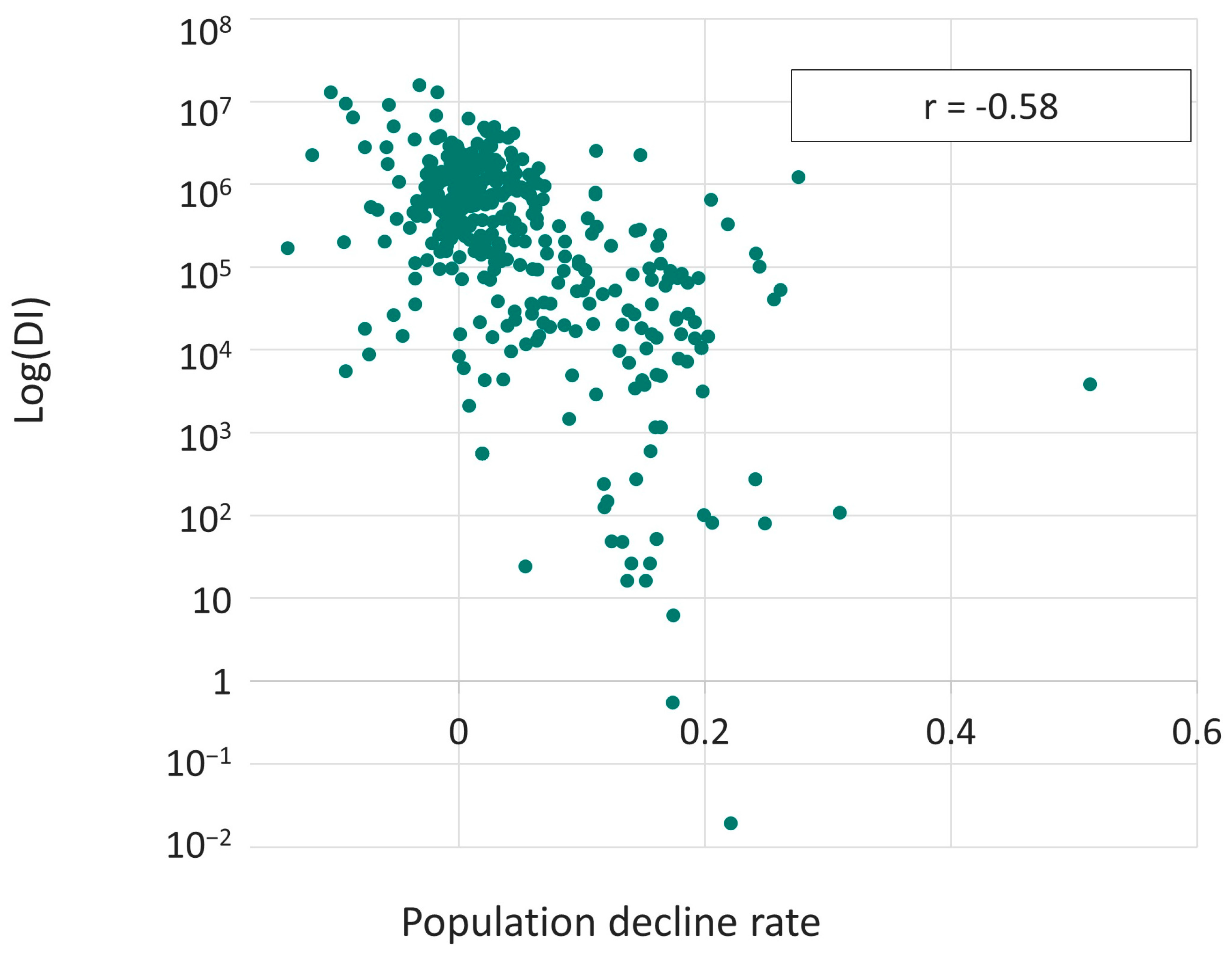
The correlation between DI and the population decline rate, based on a Japan MESH3 (
Figure 7), was analyzed using the same approach. Spearman’s correlation indicated a significant negative relationship, suggesting an ease in the population decline rate in areas with higher DI.
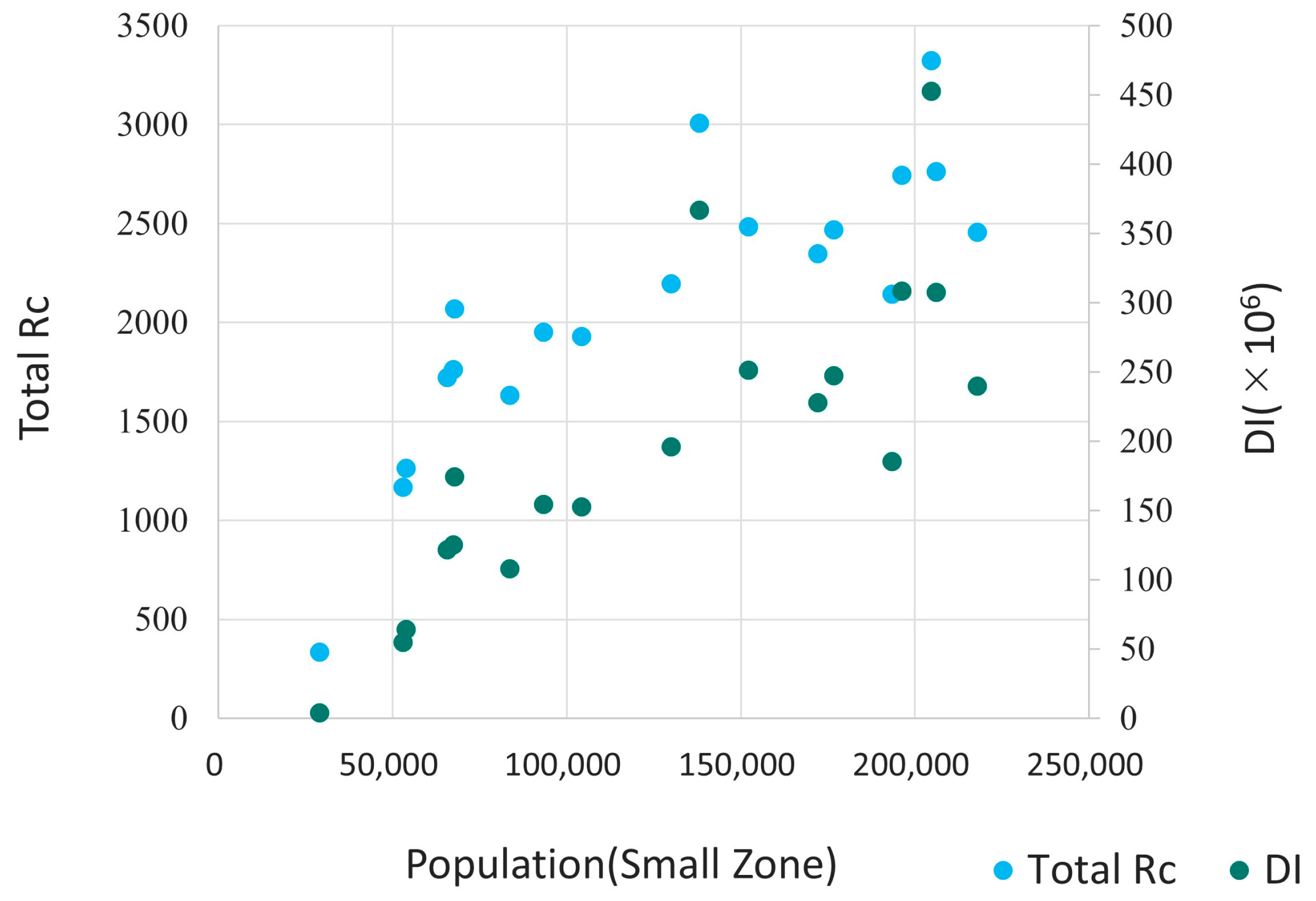
Subsequently, an analysis was conducted to explore the differences between the diversity indicator DI and Rc concerning their relationships with the population. The cumulative Rc value (i.e., total Rc in
Figure 8) for public transportation modes was calculated for each small zone, where Rc serves as the centrality index of a node from the convenience perspective. As depicted in
Figure 8, the relationship between Rc and population is non-linear, implying that a regression equation based on Rc would tend to underestimate the population in densely populated zones. In contrast, the relationship between DI and population distribution demonstrates a close-to-linear correlation, affirming a clear proportional relationship. As illustrated above, DI proves to be a more effective tool in explaining the population, particularly for the central nodes within the public transportation network.
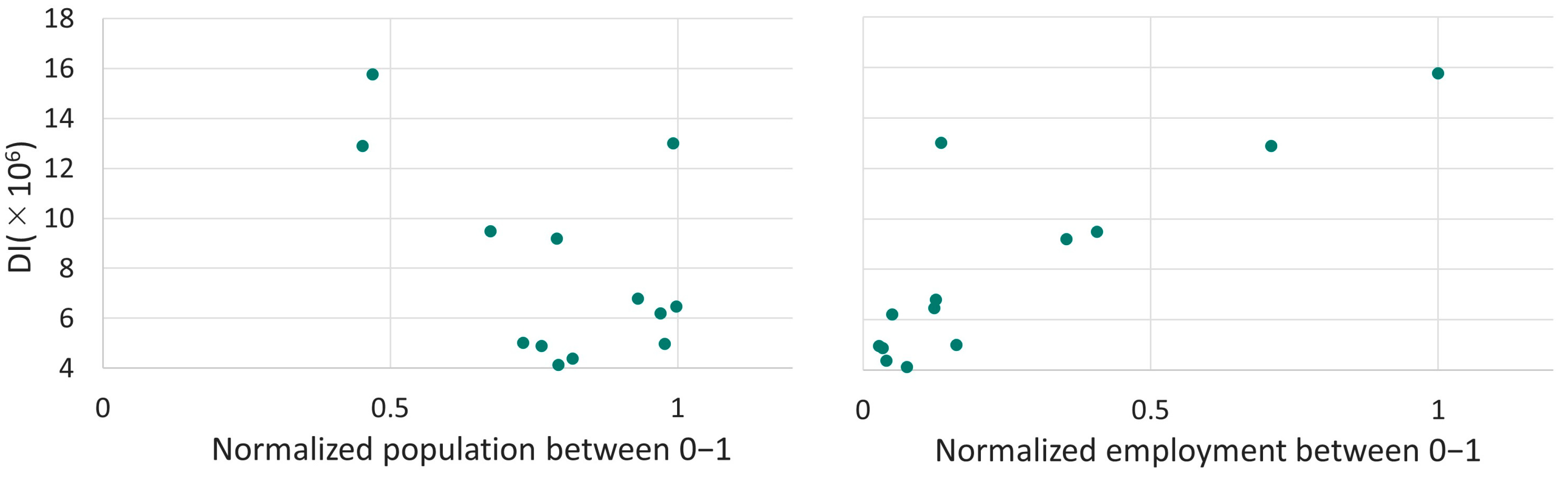
4.2. Correlation Analysis with the Employment
Next, this study examined the relationship between DI and economic indicators. The economic indicators included the number of enterprises and the number of employees categorized by industry (see
Table 4 for the summarized results). Positive correlations were observed between DI and each economic indicator. The correlation was notably strong in the tertiary industry, which has a higher employee density.
4.3. Analysis of Both the Population and the Number of Employees
Furthermore, this study focused on the areas with relatively high DI values. For mesh with a DI value exceeding 4 million, correlations were conducted on their population and employment. The data on population and the number of employees were normalized, with a maximum value of 1 (
Figure 9). The positive relationships indicated that there is a higher demand for economic activity in urban centers with a diverse transportation system.
In
Figure 9, two meshes exhibit symmetric distributions of population and the number of employees while having approximately the same DI. In the mesh with a large population, there are multiple rail stations and bus stops near the terminal, resulting in a distribution of DI within the mesh that is considered to be close to uniform. In contrast, in the mesh with a large number of employees and active economic activities, a significant terminal exists, leading to the somewhat skewed distribution of diversity. As shown above, land use may influence the distribution of DI within the mesh.
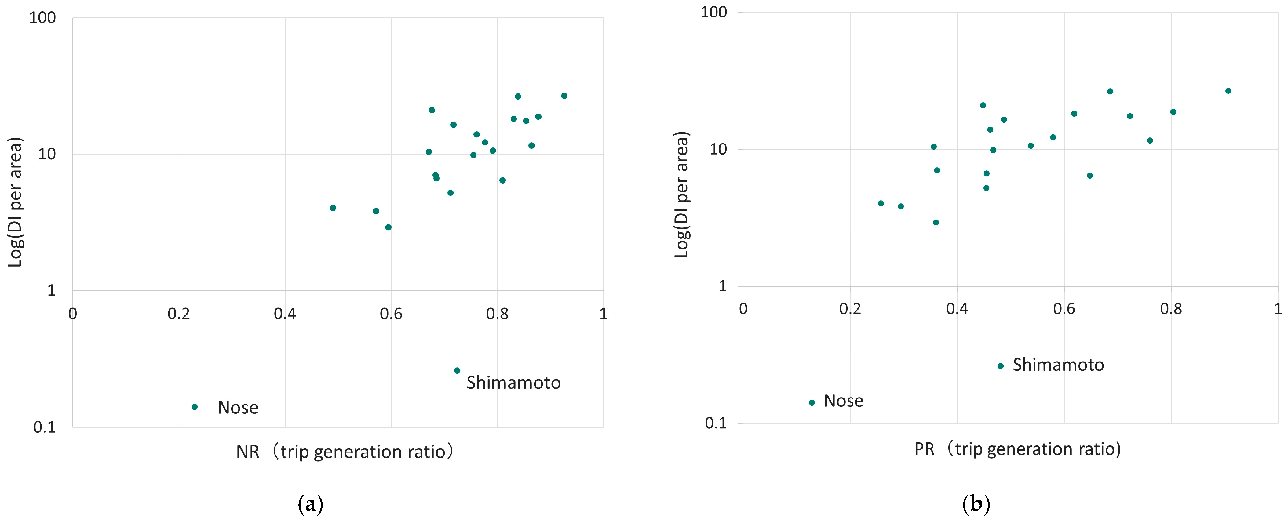
4.4. Correlation Analysis with the Trip Generation Ratio
The relationship between DI and public transportation use for each small zone was analyzed based on the person’s trip survey data obtained from the digital national land information.
First, several indices were categorized based on the representative means of transportation. T1 presents the flow regardless of the representative mode of transportation. T2 presents the flow where the representative transportation mode includes rail, bus, bicycle, or walking. Furthermore, T3 presents the flow where the representative transportation mode includes rail or bus. T4 presents the flow where the representative transportation mode includes rail, bus, car, or bike.
Based on the classification, the correlation between the trip generation ratio and DI is summarized and given in
Table 5. The results confirmed a strong correlation between DI per area, measured in square meters, and the trip generation ratio.
According to the results, the analysis primarily focuses on DI per area. The ratio of T2 flow to total flow is denoted as the non-car trip ratio to total trips (NR), and the ratio of T3 to T4 is denoted as the public transportation trip ratio to total trips, excluding walking- or cycling-only trips (PR). Based on the data of the trip generation ratio, scatter plots were created for NR (T2 flow/T1 flow) and DI per area and PR (T3 flow/T4 flow) and DI per area (
Figure 10).
The results show that almost all small zones are distributed in a linear fashion, except for Shimamoto, which is located on the outskirts of the study area and has strong ties to the Kyoto area, which is excluded in the present study.
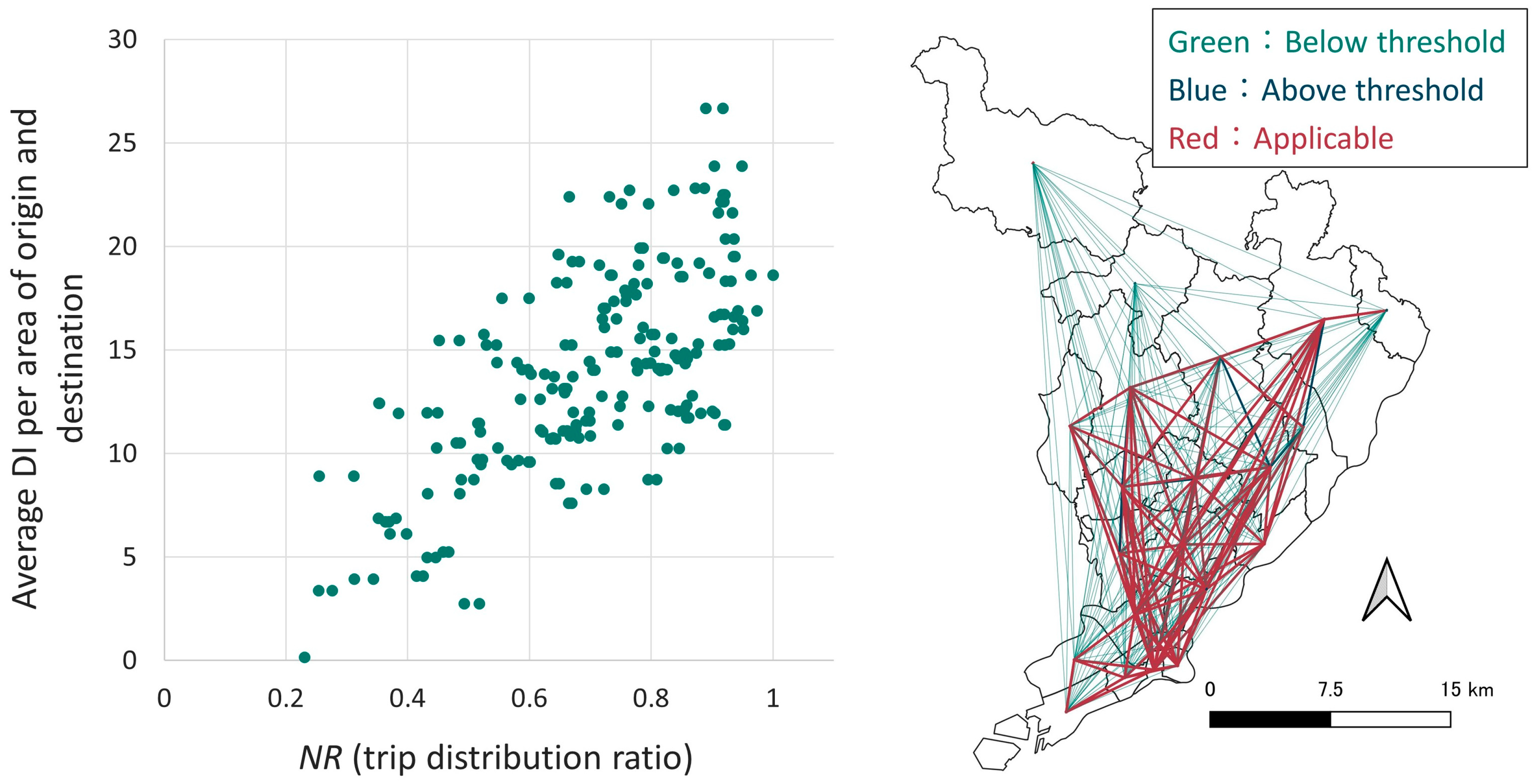
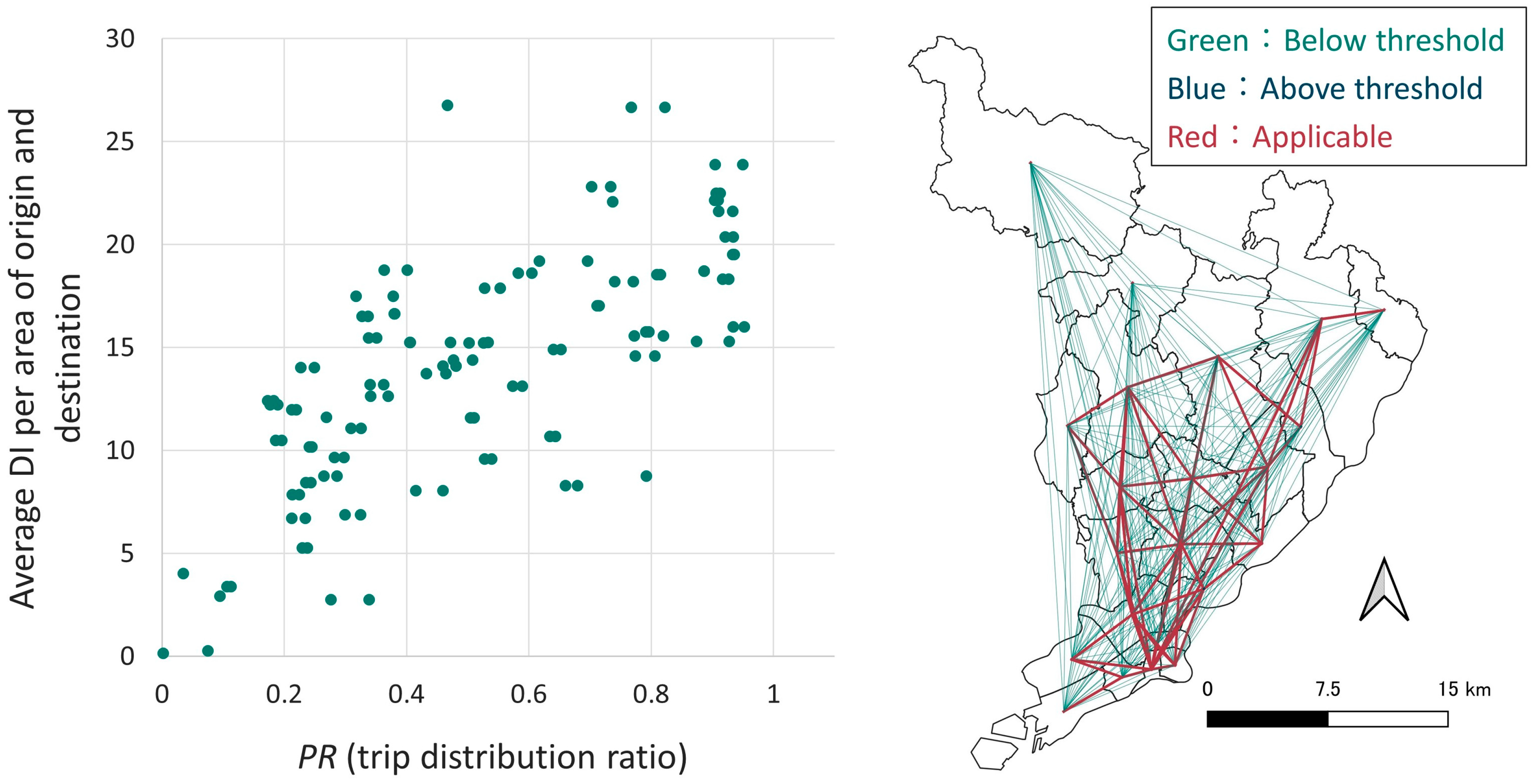
4.5. Correlation Analysis with the Trip Distribution Ratio
Based on the flow data sourced from digital national land information, this analysis focuses on the starting and ending points of the flow. In this context, the amount of traffic moving from one small zone to another is defined as flow. Nakase et al. [
22] indicated that the average diversity between the central city in an urban employment area and the target city strongly correlates with the modal share of public transportation in target cities. Therefore, in this study, the analysis is based on the hypothesis that the average of the average DI per area at the origin and destination of the flow is related to the modal share of public transportation.
There are a total of 484 flows within the study area. Based on the data of the trip distribution ratio on these flows, NR (T2 flow/T1 flow) and PR (T3 flow/T4 flow) were calculated. The correlation between these values and the average DI per area for the origin and destination was 0.51 for NR and 0.41 for PR, indicating moderate correlations. The absence of a strong correlation may be attributed to the inclusion of flows with low demand. Therefore, a more detailed analysis was conducted by ranking the 484 flows based on their respective volumes.
To identify the most relevant patterns, we established upper and lower thresholds for ranking flow volumes. Within these threshold limits, we examined the correlations between NR and DI, as well as between PR and DI. The threshold value was set at a correlation of 0.7, as it is a widely accepted indicator of statistical significance.
Flows with a correlation coefficient of over 0.7 between NR and the average DI per area were ranked from 36th to 249th (
Figure 11). Regarding PR and DI per area, the range of flow ranks extended from 17th to 138th (
Figure 12).
Patterns with both very high and very low flow volumes were not found within the interval with a correlation value exceeding 0.7. This can be attributed to the following reasons: Initially, the top-ranked flow patterns, those with high demand, often involved trips completed within the same small zone. These short-distance flows are less likely to involve public transportation since walking and bicycling are the predominant modes of transportation for such trips. On the other hand, one of the characteristics of public transportation is its suitability for high-volume transportation. Therefore, it can be concluded that the public transportation diversity targeted in this study is not suitable for patterns with low-demand flows. As a result, it can be confirmed that the modal share of transportation is related to DI per area for flows with high demand.
4.6. Analysis of the Presence of Railroads in Terms of DI
To maintain DI, there are two approaches: one is to maintain the level of service, and the other is to sustain the operation of transportation modes. The former involves maintaining service frequency and implementing other measures to ensure user convenience. The latter is aimed at preserving or increasing DI by introducing new transportation services that make use of existing facilities or by maintaining existing transportation systems. In this study, the analysis mainly focuses on the latter approach.
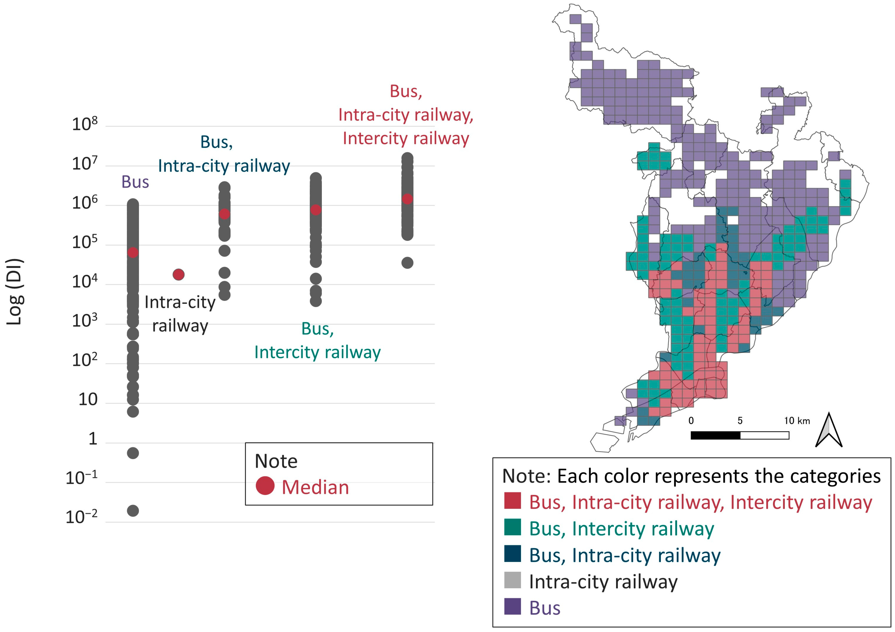
Each mesh was classified into five categories: those within the service area of a bus stop; those within the service area of an intracity rail station; those within the service area of both a bus stop and intracity rail station; those within the service area of a bus stop and intercity rail station; and those within the service area of all mentioned transportation modes (
Figure 13).
It should be noted that the classification is not based on the presence or absence of a station but on whether a node is included or excluded from a public transportation service area. The DI is expected to be higher within the service area of public transportation. On the other hand, a more detailed analysis was conducted for the area with a DI ranging from 10,000 to 1,000,000, as all public transportation patterns that impact this area are present: only bus; bus and intracity rail; bus and intercity rail; and bus, intracity rail, and intercity rail.
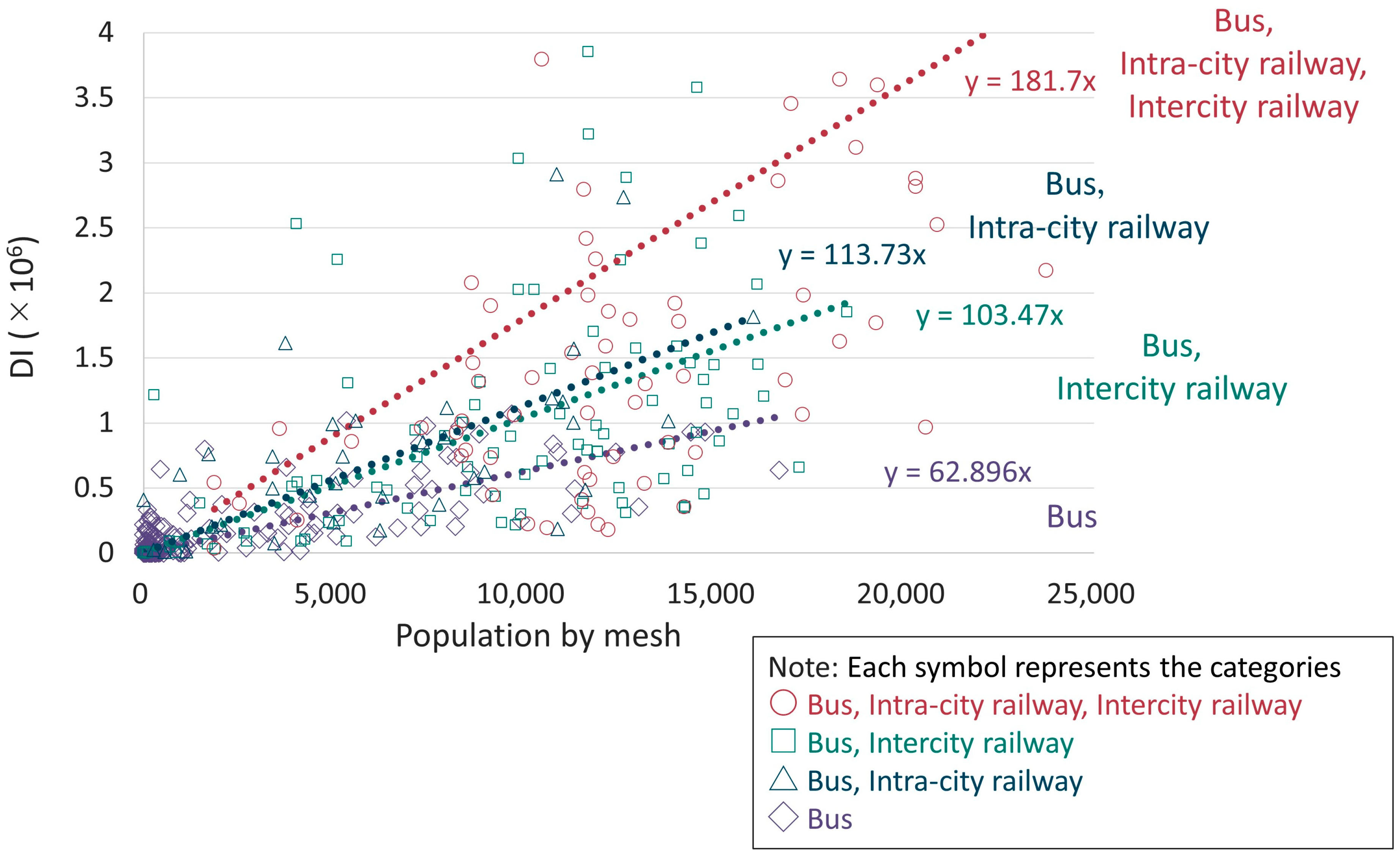
Figure 14 illustrates the relationship between the population decline rate and the DI. The findings suggest that population decline is more likely to be suppressed in areas where diversity is secured by rail transport, even in the same DI section. Thus, it seems desirable to ensure transportation diversity by using multiple transportation modes, especially in areas where population decline is desired to be controlled.
There is a mesh in which there is no bus service but is served by an intracity railway station. This mesh was being developed as a residential area at the time of data acquisition, and the opening of the bus lines resolved this situation. Therefore, the relationship between population and DI is demonstrated for each of the four categories, excluding this mesh (
Figure 15). The findings reveal that the DI per population is higher for the meshes within the service area of the railway than for the other meshes.
5. Discussion
5.1. Evaluating Public Transportation from the Perspective of Diversity
In this study, we evaluated public transportation systems from the perspective of diversity. This study is subsequent research of a previous study conducted by Nakase et al. (2021) [
22]. The results of this study revealed a significant relationship between the diversity index (DI) and population, employment, and the modal share of public transportation. Specifically, the correlation between population and DI was greater than 0.8, and the correlation coefficient between the number of employees and DI was also larger than 0.8. Additionally, it was found that the modal share of public transportation was related to DI per area for flows with high demand. Above all, it is suggested that the diversity of public transportation has a relation to social welfare and human well-being. To clarify such a latent connection, we refer to the concept proposed by Hashimoto [
30], who showed the connection between ecosystem diversity and human well-being.
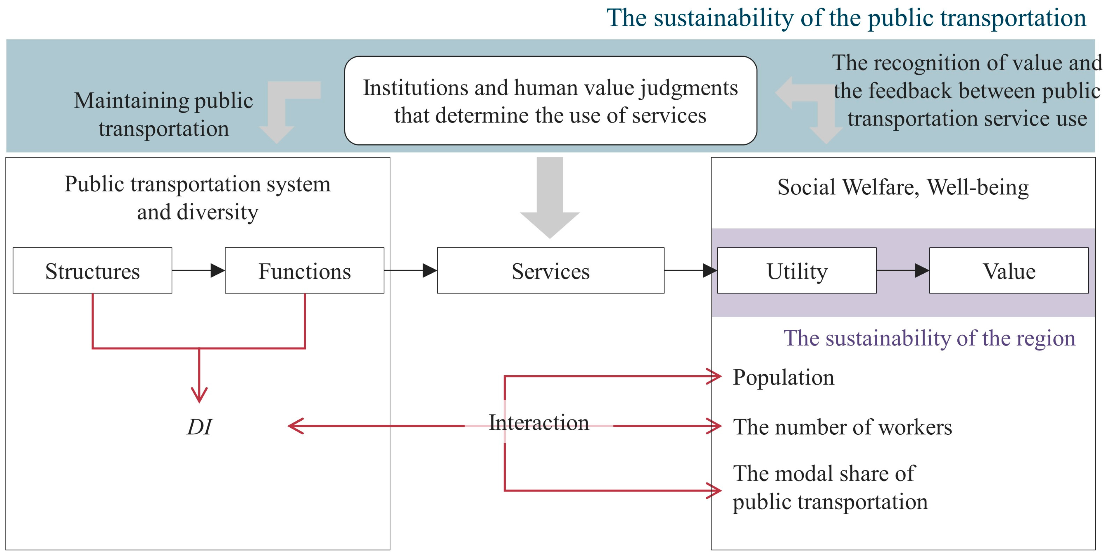
Hashimoto [
30], referring to Kumar’s book, suggested that there are five steps from ecological structures to achieve human well-being. First, there are structures and processes, such as vegetation, and then functions come to exist. The functions of the ecosystem were presented as a slow flow of water. The given two steps are regarded within the scope of ecosystems and biodiversity. The next step is services. The services can be interpreted as benefits provided directly or indirectly by ecosystems. The services are then converted into benefits and finally into value in the form of willingness to pay. The benefits and values are collectively referred to as human well-being. The recognition of the value and the feedback between ecosystem service use leads to institutions and human value judgments that determine the use of services. A series of cycles leads to the conservation of ecosystems and the modification of services.
Transportation diversity can be interpreted using the mentioned analogy. First, the structure can be described as the facilities and institutions of each public transportation service. The combination of these structures provides the functions of transportation. The benefits obtained according to the functions are services, and the individual and social effects obtained by the services can be expressed as a utility. Finally, the diversity of public transportation is maintained based on value, which is the willingness to pay for these services (
Figure 16).
Previous studies have pointed out the impact of public transportation diversity on these utilities and services. According to Makarewicz et al.’s results [
31], diverse transportation options could improve lives, especially for low- and middle-income residents. The middle-income residents, who have multiple choices for transportation, are more satisfied with their health and what they are achieving in life. Talmage et al. [
32] revealed the positive correlations between higher levels of multimodal transport and better quality of life in both counties and metropolitan areas via bivariate and multivariate analysis. Although these studies did not quantify the diversity of public transportation, they suggest the effects of a diverse transportation system. Another study conducted by Gebhardt et al. [
33] also showed the positive effect of using multimodal transportation, which combines different modes of transportation rather than traveling by a single mode.
One of the characteristics of public transportation systems is that external effects are extremely common. Therefore, it is not desirable to modify public transportation systems based solely on indicators such as direct revenue. Nishimura et al. [
34] took cross-sector effects into account to calculate the effects (measured in value) of maintaining public transportation. There has been increasing interest in evaluating public transportation from multiple perspectives. The ecosystem that is used as an analogy in this study is also characterized by large external effects. In this study, we attempted to clarify the effects and values of public transportation from the perspective of “diversity,” which is similar to the focus on ecosystems.
5.2. From the Viewpoints of Transportation and Regional Sustainability
In response to the declining and aging population and the resulting low urban population density, the Ministry of Land, Infrastructure, Transport and Tourism (MLIT) aims to realize sustainable cities where residences and urban functions are concentrated around public transportation based on the concept of “compact plus network” as mentioned above.
Based on the analytical results, it is considered that maintaining a diverse transportation system with multiple modes is more effective than relying on a single mode. Comparisons between regions with similar DI revealed that the extent of population decline was less pronounced in areas where multiple transportation modes with distinct roles coexisted. Thus, it is suggested that such regions can exhibit greater sustainability. This indicates that nodes between different modes of public transportation can become central locations in the area and can serve as hubs for residential and daily life services. The loss of a nodal point between different levels of public transportation may lead to the dispersion of residential and daily life service centers, which is likely to worsen the sustainability of the region. Therefore, modifying traffic in terms of profit based on a short-term perspective may lead to a loss of regional sustainability in the long term. In addition, based on the ideas presented in this study, recognizing the value of sustaining transportation may avoid the deterioration of the sustainability of the region and its transportation system. Furthermore, even in areas where it is difficult to maintain the existing transportation system, the introduction of demand-responsive transport can prevent a sharp decline in the level of diversity and maintain the nodes containing various transportation options. Thus, it may be possible to prevent extreme regional decline due to a rapid decrease in the number of public transportation users and the population.
This study further confirmed that the proposed diversity index (DI) exhibits a distinct proportional relationship with the population when compared to a network-based assessment. This finding suggests that maintaining a central node’s role with a range of public transportation services has the potential not only to sustain but even enhance the local population. In the context of Transit-Oriented Development (TOD), the 3Ds—Density, Diversity, and Design—are recognized as crucial elements. While diversity in TOD traditionally refers to land use diversity, our analysis results propose that public transportation diversity is equally significant. This study provides valuable insights for advancing TOD strategies in the future.
6. Conclusions
This study seeks to quantify the concept of transportation diversity while considering connectivity among services within the network. It contributes to the literature by quantifying and empirically assessing the concept and achieving a higher spatial resolution than previous studies. This enables a more sensitive evaluation of changes in the public transportation system in terms of diversity. Given the need for sustainable public transport with diverse transportation options, particularly in the context of depopulation, this feature provides an advantage for informing transportation and regional planning.
This study developed a methodology and indicators to evaluate public transportation networks from a perspective of diversity, taking the connectivity within the transport network into account. In this study, the spatial resolution of the diversity index was according to Japan MESH3, the basic grid square suggested officially in Japan. The key findings of this study are summarized as follows.
According to the correlation analysis results, it is revealed that strong correlations exist between the diversity of public transportation and population, employment, and public transport modal share. In the regions with relatively high travel demand, a positive correlation was further found between diversity, residence, employment, and transportation flow. Furthermore, we discussed the connection between diversity and regional and transportation sustainability, attempting to inform practical applications. Looking into the hierarchical structure of transportation, this study identified the impacts of the presence or absence of rail transportation. The results show that the population decline tends to be eased in areas where a multimodal transportation system maintains diversity. This suggests that it is important to maintain diversity by offering various public transportation options in the core area of the region.
The results further emphasize the significance of diverse transportation services for establishing a sustainable public transportation system within the constraints of a declining population. As sustainable transportation is a prerequisite for urban sustainability, maintaining transportation diversity is expected to encourage urban sustainability. Therefore, by integrating with urban development, it will be possible to steer a diverse public transportation system toward the realization of sustainable cities and transportation.
This study has several limitations. It focused on northern Osaka Prefecture as the study site without including a broader geographical area. Furthermore, the study did not explore the financial aspects of maintaining transportation diversity, and practical maintenance measures were not fully considered. Future research could conduct a time-series analysis and take financial burdens into consideration. Considering the environmental benefits and social adoption of shared mobility, like bike sharing [
35], future studies could enhance the transportation diversity index by incorporating public or shared mobility services as part of multimodal systems. Acknowledging the limitations related to data availability and parameter settings, future research directions could also include testing the sensitivity of key assumptions, such as equivalent time values concerning transfer resistance or speed of modes, to better reflect the real-world level of service.
Author Contributions
Conceptualization, T.H. and K.D.; supervision, K.D. and K.Y.; methodology, T.H.; validation, K.Y. and K.D.; data curation, T.H.; writing—original draft preparation, T.H.; writing—review and editing, C.-C.C. All authors have read and agreed to the published version of the manuscript.
Funding
This research received no external funding.
Institutional Review Board Statement
Not applicable.
Informed Consent Statement
Not applicable.
Data Availability Statement
The data presented in this study are available on request from the corresponding author.
Conflicts of Interest
The authors declare no conflict of interest.
References
- Population Estimates (as of 1 October 2021). Available online: https://www.stat.go.jp/data/jinsui/2021np/index.html (accessed on 13 March 2023).
- White Book on Transportation Policy. Available online: https://www.mlit.go.jp/sogoseisaku/transport/content/001486804.pdf (accessed on 13 March 2023).
- Compact Town Development to Be Promoted by Everyone. Available online: https://www.mlit.go.jp/common/001171816.pdf (accessed on 13 March 2023).
- Recognition of Issues and Information Disclosure Concerning Local Lines. Available online: https://www.westjr.co.jp/press/article/items/220411_02_local.pdf (accessed on 13 March 2023).
- FY 2020 Regional Public Transportation Human Resource Development Training: Toward the Realization of Sustainable Regional Public Transportation. Available online: https://wwwtb.mlit.go.jp/hokkaido/bunyabetsu/tiikikoukyoukoutsuu/78jinzaiikusei/koutuukikakuka.pdf (accessed on 13 March 2023).
- The Nation’s First Joint Management between Railroad and Bus Operators Will Start in Southern Tokushima Prefecture. Available online: https://www.mlit.go.jp/report/press/content/001471342.pdf (accessed on 13 March 2023).
- Banister, D. The sustainable mobility paradigm. Transp. Policy 2008, 15, 73–80. [Google Scholar] [CrossRef]
- Jabareen, Y.R. Sustainable Urban Forms, Their Typologies, Models, and Concepts. J. Plan. Educ. Res. 2016, 26, 38–52. [Google Scholar] [CrossRef]
- Jeon, C.M.; Amekudzi, A. Addressing Sustainability in Transportation Systems: Definitions, Indicators, and Metrics. J. Infrastruct. Syst. 2005, 11, 31–50. [Google Scholar] [CrossRef]
- Tang, S.; Lo, H.K. The impact of public transport policy on the viability and sustainability of mass railway transit—The Hong Kong experience. Transp. Res. Part A Policy Pract. 2008, 42, 563–576. [Google Scholar] [CrossRef]
- Litman, T.; Burwell, D. Issues in sustainable transportation. Int. J. Glob. Environ. 2006, 6, 331–347. [Google Scholar] [CrossRef]
- Goldman, T.; Gorham, R. Sustainable urban transport: Four innovative directions. Technol. Soc. 2006, 28, 261–273. [Google Scholar] [CrossRef]
- Kii, M.; Suzuki, T.; Tanishita, M.; Doi, K. Strategic visioning model for sustainable urban transport in depopulating society. Proc. JSCE D 2009, 65, 303–316. [Google Scholar] [CrossRef]
- Sutradhar, U.; Badhrudeen, M.; Chauhan, R.S.; Derrible, S. A Survey to Investigate Transport Conditions in Depopulating Cities in Illinois. Transp. Res. Interdiscip. Perspect. 2023, 21, 100886. [Google Scholar] [CrossRef]
- Watanabe, T.; Shibata, M.; Suzuki, T. A study on the evaluation method of inter-regional transportation network based on multi-objective optimization. JSCIP 2016, 72, I903–I916. [Google Scholar]
- Hasegawa, D.; Suzuki, T. Theoretical approach for the selection of public transport system considering urban density and travel distance. J. City Plan. Inst. Jpn. 2017, 52, 1284–1289. [Google Scholar] [CrossRef]
- Litman, T. Evaluating Transportation Diversity: Multimodal Planning for Efficient and Equitable Communities; Victoria Transport Policy Institute: Victoria, BC, Canada, 2017. [Google Scholar]
- Fujiwara, Y.; Urata, J.; Fujiwara, A.; Chikaraishi, M. Exploring Diversity of Public Transport Usage with Smart Card Data and Its Associations with Accessibility and Land Use Patterns. J. East. Asia Soc. Transp. Stud. 2021, 14, 779–794. [Google Scholar]
- Feng, C.M.; Hsieh, C.H. Implications of Transport Diversity for Quality of Life. J. Urban Plan. Dev. 2009, 135, 13–18. [Google Scholar] [CrossRef]
- Ren, Z.; Fusco, G.; Lownes, N.; Zhu, J. Entropy-Based Diversity Quantification of Multimodal Transportation Systems: Physical Infrastructure Perspective versus Travel Behavior Perspective. J. Urban Plan. Dev. 2022, 148, 04022029. [Google Scholar] [CrossRef]
- Li, J.; Fu, J.; Gao, J.; Zhou, R.; Wang, K.; Zhou, K. Effects of the spatial patterns of urban parks on public satisfaction: Evidence from Shanghai, China. Landsc. Ecol. 2023, 38, 1265–1277. [Google Scholar] [CrossRef] [PubMed]
- Nakase, R.; Chou, C.C.; Aoki, Y.; Yoh, K.; Doi, K. Evaluating Hierarchical Diversity and Sustainability of Public Transport: From Metropolis to a Weak Transport Demand Area in Western Japan, Frontiers in Sustainable Cities, Sustainable Infrastructure. Front. Sustain. Cities 2021, 3, 667711. [Google Scholar] [CrossRef]
- Rahimi-Golkhandan, A.; Garvin, M.J.; Brown, B.L. Characterizing and measuring transportation infra-structure diversity through linkages with ecological stability theory. Transp. Res. Part A Policy Pract. 2019, 128, 114–130. [Google Scholar] [CrossRef]
- Hatoko, M. A basic study on measuring diversity index of inter-regional access and its relationship with regional structure. JSCIP 2019, 75, I201–I212. [Google Scholar] [CrossRef]
- Hiller, B.; Hanson, J. The Social Logic of Space; Cambridge University Press: London, UK, 1984. [Google Scholar]
- Hiller, B.; Hanson, J. Space Is the Machine: A Configurational Theory of Architecture; Space Syntax: London, UK, 2007. [Google Scholar]
- Kobayashi, W.; Watabe, S.; Iwakura, S.; Yamashita, Y. Estimation model of passenger waiting time on boarding based on urban railway departure time intervals. JSCIP 2019, 75, I693–I700. [Google Scholar] [CrossRef]
- Nakamura, K.; Morimoto, A. A study on transfer resistance focused on the utilization of public transportation. JSTE J. Trtafic Eng. (Spetial Ed. A) 2021, 7, A270–A279. [Google Scholar]
- Part II: Manual for Evaluation of Transit Convenience at Transit Nodes by Generalized Time (Draft). Available online: http://www.nilim.go.jp/lab/bcg/siryou/tnn/tnn0297pdf/ks0297010.pdf (accessed on 13 March 2023).
- Hashimoto, S. Thinking about Responses to Mainstreaming of ecosystem services, journal of the Japanese Society of Irrigation. Drain. Rural. Eng. 2012, 80, 897–902. [Google Scholar]
- Makarewicz, C.; Németh, J. Are multimodal travelers more satisfied with their lives? A study of accessibility and wellbeing in the Denver, Colorado metropolitan area. Cities 2018, 74, 179–187. [Google Scholar] [CrossRef]
- Talmage, C.A.; Frederick, C. Quality of Life, Multimodality, and the Demise of the Autocentric Metropolis: A Multivariate Analysis of 148 Mid-Size U.S. Cities, Social Indicators Research. Int. Interdiscip. J. Qual.-Life Meas. 2019, 141, 365–390. [Google Scholar]
- Gebhardt, L.; Krajzewicz, D.; Oostendorp, R. Intermodality—Key to a More Efficient Urban Transport System? ECEEE Summer Study Proceedings; ECEEE: Stockholm, Sweden, 2017; pp. 759–769. [Google Scholar]
- Nishimura, K.; Higashi, T.; Doi, T.; Kita, H. Quantitative value of regional public transportation measured by cross sector effects. JSCIP 2019, 75, I809–I820. [Google Scholar] [CrossRef]
- Guangnian, X.; Qiongwen, L.; Anning, N.; Zhang, C. Research on carbon emissions of public bikes based on the life cycle theory. Transp. Lett. 2023, 15, 278–295. [Google Scholar] [CrossRef]
Figure 1.
Population trends in Japan [
1].
Figure 1.
Population trends in Japan [
1].
Figure 2.
Automobile share and population density in Japan [
2].
Figure 2.
Automobile share and population density in Japan [
2].
Figure 3.
Analysis Framework.
Figure 3.
Analysis Framework.
Figure 4.
Study area in this study.
Figure 4.
Study area in this study.
Figure 5.
Taxonomic distance between public transportation.
Figure 5.
Taxonomic distance between public transportation.
Figure 6.
The relationship between DI and the population. (a) The relationship between DI and the population of small zone; (b) the relationship between DI and the population based on Japan MESH3.
Figure 6.
The relationship between DI and the population. (a) The relationship between DI and the population of small zone; (b) the relationship between DI and the population based on Japan MESH3.
Figure 7.
The relationship between DI and population decline rate.
Figure 7.
The relationship between DI and population decline rate.
Figure 8.
Overlapping scatter plots of population vs. DI and population vs. Rc, excluding small zones with less than 20,000 people.
Figure 8.
Overlapping scatter plots of population vs. DI and population vs. Rc, excluding small zones with less than 20,000 people.
Figure 9.
Analysis of both the population and the number of employees.
Figure 9.
Analysis of both the population and the number of employees.
Figure 10.
The relation between DI per area and the index of the trip generation ratio. (a) The relationship between DI and NR; (b) the relationship between DI and PR.
Figure 10.
The relation between DI per area and the index of the trip generation ratio. (a) The relationship between DI and NR; (b) the relationship between DI and PR.
Figure 11.
The relationship between NR and the average DI per area of origin and destination.
Figure 11.
The relationship between NR and the average DI per area of origin and destination.
Figure 12.
The relationship between PR and the average DI per area of origin and destination.
Figure 12.
The relationship between PR and the average DI per area of origin and destination.
Figure 13.
Five categories of each mesh. The red dots present the medians.
Figure 13.
Five categories of each mesh. The red dots present the medians.
Figure 14.
The relationship between the population’s declining rate and DI between 10,000 and 1,000,000.
Figure 14.
The relationship between the population’s declining rate and DI between 10,000 and 1,000,000.
Figure 15.
The relationship between population and DI for each of the four categories.
Figure 15.
The relationship between population and DI for each of the four categories.
Figure 16.
Five steps in the pathway of diversity of public transportation and processes to human well-being.
Figure 16.
Five steps in the pathway of diversity of public transportation and processes to human well-being.
Table 1.
The speed of each mode.
Table 1.
The speed of each mode.
| Traffic Mode | Travel Speed |
|---|
| Intercity rail (express train) | 60 km/h |
| Intercity rail (semi-speed train) | 45 km/h |
| Intercity rail (local train) | 30 km/h |
| Intra-city rail | 30 km/h |
| Bus | 10 km/h |
| Walk | 4 km/h |
Table 2.
Transfer resistance concerning the uncertainty of travel time.
Table 2.
Transfer resistance concerning the uncertainty of travel time.
| Next Mode of Public Transportation to Use | Equivalent Time Values (min) |
|---|
| Train | 7 |
| Bus | 9 |
| These values are decided by referring [28] |
Table 3.
Equivalent time coefficients.
Table 3.
Equivalent time coefficients.
| Types of Movement | Equivalent Time Coefficients |
|---|
| Horizontal | 1.35 |
| Vertical Ascending | 1.90 |
| Vertical descent | 1.41 |
Table 4.
The relationship between DI and economic indicators.
Table 4.
The relationship between DI and economic indicators.
| | Number of Enterprises | Number of Employees |
|---|
Secondary
Industry | Tertiary
Industry | Secondary
Industry | Tertiary
Industry | Total |
|---|
| Correlation coefficient | 0.75 | 0.86 | 0.69 | 0.82 | 0.81 |
Table 5.
The rank correlation coefficient between the amount of concentration and DI.
Table 5.
The rank correlation coefficient between the amount of concentration and DI.
| | DI | DI per Area | DI per Population |
|---|
| Sum of T1 | 0.68 | 0.57 | 0.10 |
| Sum of T2 | 0.59 | 0.66 | 0.10 |
| Sum of T3 | 0.41 | 0.75 | 0.06 |
| Ratio of T2 to total | −0.18 | 0.70 | −0.12 |
| Ratio of T3 to total | −0.13 | 0.70 | −0.04 |
| Ratio of T3 to T4 | −0.20 | 0.69 | −0.14 |
| Disclaimer/Publisher’s Note: The statements, opinions and data contained in all publications are solely those of the individual author(s) and contributor(s) and not of MDPI and/or the editor(s). MDPI and/or the editor(s) disclaim responsibility for any injury to people or property resulting from any ideas, methods, instructions or products referred to in the content. |
© 2023 by the authors. Licensee MDPI, Basel, Switzerland. This article is an open access article distributed under the terms and conditions of the Creative Commons Attribution (CC BY) license (https://creativecommons.org/licenses/by/4.0/).


