1. Introduction
Today, public spaces are the preferred places for analyzing, designing, and experiencing city life, as well as being where citizens live and interact. Urban open spaces have played a significant role in the cultural, political, and economic life of societies since the dawn of time.
Public spaces may be a potent force for change since they contain essential social and environmental infrastructure. The advantages of urban public spaces help address several community demands, from sustainability to safety, and serve as a lever that advances community satisfaction and vitality. In the case of dense and historic urban fabrics within historic cities, the regeneration needs are one of the key approaches of contemporary urban policies, induced by citizens’ demands and the need to countermeasure the negative impact of previous planning experiences and the effects of climate change. In current scientific debates, the question of how to approach the assessment of urban open spaces is therefore central.
The themes of the livability and usability of open spaces are more relevant than ever, especially in relation to the post-COVID-19 pandemic situation and in response to the increasingly evident effects of climate change. Therefore, there is an increasingly pressing need to uncover the singularities of the individual disciplines that have always dealt with the analysis of urban fabrics and to unify reading tools and methods in a single integrated approach that can provide multifaceted solutions to help adapt projects of urban regeneration.
For these reasons, public spaces were chosen as the main research topic of this study. The proposed methodology centers around demonstrating the potential of integrating, in a shared methodology, morphological analysis, pedestrian flow mapping, and environmental analysis to support the design and renovation process.
Urban analysis is a complex subject. When it comes to urban open spaces, diverse tools and numerous sources of data and information can be used to interpret this complex topic. These data involve both physical and material aspects of the urban fabrics; several approaches are focused on historical perspectives [
1], on their state of maintenance, and on intangible aspects linked to the way that citizens make use of a city and its public spaces [
2]. Urban open spaces have played a significant role in the cultural, political, and economic life of societies since the dawn of time; however, any process of urban analysis cannot neglect environmental aspects.
Urban Morphology, an interdisciplinary field involving architecture, landscape architecture, architectural history, geography, history, urban planning, and archeology, faces significant challenges in depicting complex city relationships. It requires new analytical tools and a capacity for synthesis among different disciplines, needs, and information.
The urban fabric is a key small-scale component of urban forms. The Italian School of Urban Morphology [
3,
4,
5,
6,
7], whose role is to propose the direct observation of urban fabrics by interpreting the facades shaping the images of public spaces and the other information hidden inside the structures of buildings, has examined the quantitative and qualitative aspects of urban forms and the wide variety of components since the last century. These days, urban surveying can be carried out utilizing tools like RDF, drones, and laser scanners to identify the physical shapes of a city and comprehend its consistency in time and materials [
8,
9].
This article demonstrates how three different research areas—urban morphology analysis, pedestrian flow analysis, and environmental analysis—can be profitably integrated in the study of urban forms, developing a multilevel approach that, thanks to the use of next-generation software and tools such as ENVI-met 4.4 [
10], QGIS 3.28.1 “Firenze”, and GPS and its incorporation of urban morphology (UM) analysis, pedestrian flow analysis (PFA), and environmental analysis (EA), allows one to extract valuable information on building types, construction phases, functions, microclimatic values, etc., of dense and compact urban fabrics.
The innovative approach underlying the present study therefore comprises a unique workflow that is being presented in for the first time in this paper, and the results and findings derived from the readings of the different maps, despite the fact that they pertain to different research areas, can support each other by validating the results deriving from the other evaluations. The integrated approach proposed herein is therefore able to provide more in-depth, multilayered analyses than those which can be deduced from using the analyses methods individually. In this way, it can more effectively support both the reading and interpretation phase of complex urban processes and be used in recovery and revitalization interventions for urban fabrics.
The methodology proposed in this article is applied to two case studies in the city of Venice (IT).
2. Background
Urban morphology analysis is centered around studying urban contexts through the analysis of urban fabrics; an urban fabric is defined as a specific combination of local patterns made up of buildings, streets, and open spaces and considered as the original and unique outcome of the conscious and unconscious design of the physical city [
11]. Urban morphology is a discipline that was created in the early 1950s as a tool for understanding the problems of the modern city, but it is now clear that it should be integrated with other subjects and tools to be more prepared to face the challenges of evolving societal and citizen needs.
In recent decades, the analysis of the existing city has produced a valid body of research [
12] which has highlighted the need to adopt an increasingly multidisciplinary approach [
13] to address the complex problems of the historical city and contemporary life’s needs in today cities [
14]. Innovative approaches from other disciplines have been paired with urban morphology analysis to bring about diverse solutions that would allow traditional urban fabric analysis to fully integrate historical [
15], pedestrian [
16,
17], environmental [
18,
19], and social perspectives [
20].
Given the inherent multidisciplinary character of urban morphology analysis, there is an ever-increasing number of studies combining the study of urban forms with very distinct themes. What remains disregarded is a reading approach dedicated to the open spaces of densely built cities, typical of historic cities, in which the synchronous reading of different parameters acts as an integrated system of information to support the knowledge of open spaces, their uses, and citizens’ uses.
Recent studies [
21] have emphasized the benefits of synchronous readings from an environmental and morphological perspective, proposing readings of urban fabrics using morphological analysis tools, including analyses of the functions and areas of relevance and thermal analyses of open spaces.
Some contributions focus on the compatibility of the relationship between the morphological and thermal–hygrometric properties of historical spaces [
22], paying attention to the relationship between indoor and outdoor spaces considering climate change effects [
23].
An examination of pedestrian flows in relation to the structure of urban areas has been previously carried out [
24], and an evaluation of the interdependent relationship between nature-based solutions and urban areas, as well as the application of climate-resilient thinking to conventional urban development techniques, has also been carried out [
25]. Lastly, few studies present a methodology for the integration of Computational Fluid Dynamics (CFD), microclimate simulations, and the Geographic Information System (GIS) in the context of existing urban fabrics [
26].
The study aimed to develop an integrated approach to assess outdoor spaces in dense urban areas. The approach combines urban morphology analysis, pedestrian movement flow analysis, and environmental analysis to provide a dynamic tool for urban analysis, urban regeneration processes, and new designs.
3. Materials and Methods
We propose a research methodology that includes three main tasks.
First, a detailed morphological analysis is conducted on two selected urban fabrics; then, the city’s pedestrian movement flows are analyzed, and lastly, an environmental and thermal comfort analysis is set up for each urban texture.
Although the three tools pertain to different disciplines, the objective of this paper is to demonstrate the correspondences and mutual relationships that can derive from the three disciplines and their related instruments.
The method presented in this paper is based on the comparative reading of results obtained through the three main disciplines (UM, PMF, and EA), with the aim of uncovering to what extent the data are comparable and how they can be integrated in assessing urban outdoor spaces.
The output data deriving from each reading layer (UM, PMF, and EA) are then presented via different colored urban maps, which were constructed to investigate the usability and livability of the open spaces in the dense and compact urban tissue. Even though the three layers focus on different urban aspects, they can provide architects, urban planners, and designers with information that could be useful for their projects.
The selected case studies are two open spaces (herein referred to as Campi) in the city of Venice (Italy).
The city of Venice, in fact, due to the clearness of its transformation processes, its pedestrianism, and for the huge topicality of its urban structures, represents an ideal case study for our integrated approach.
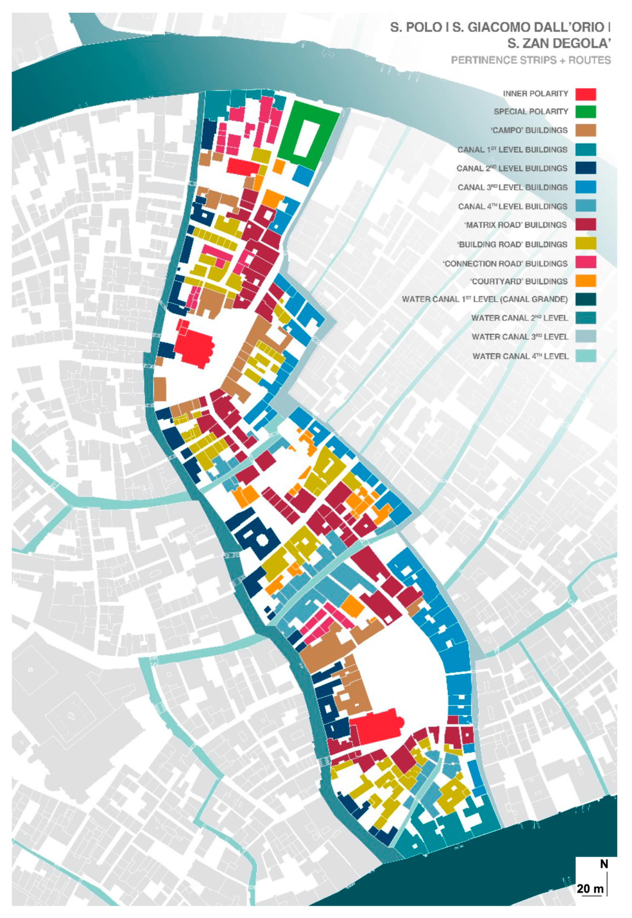
The first stage involved a pertinence strip and route analysis and functional analysis mapping, a widely recognized, valuable tool for providing a large amount of information on an area’s plot system, building types, and the evolution of its typological process that gathers a large amount of data on functions and their distribution in the urban fabrics.
The importance of the pertinence strip and route maps lies in their directly connected routes, as important public spaces for urban connection, and the buildings that define these routes. Each route is, in fact, characterized by its own pertinence strip shaped by the buildings’ envelopes served by the same route.
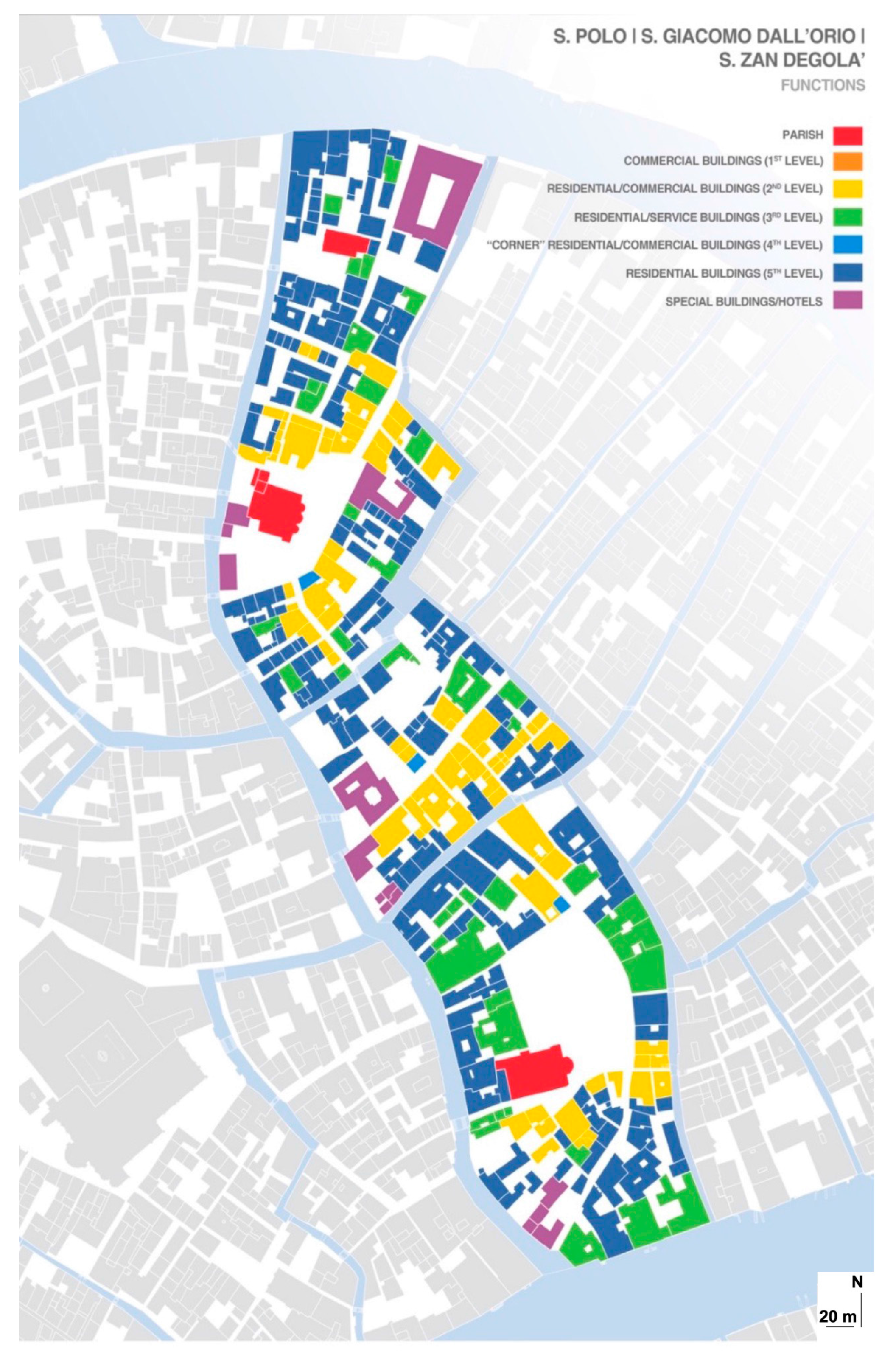
Functional analysis mapping distinguishes parish, residential, commercial, and special buildings. In this phase, the GIS is used to integrate, at a quantitative level, typo-morphological and functional data with other material data, which pertain to, for example, the heights of buildings, the degree of openness regarding their facades, the conservation conditions of buildings, and their historical stratigraphy.
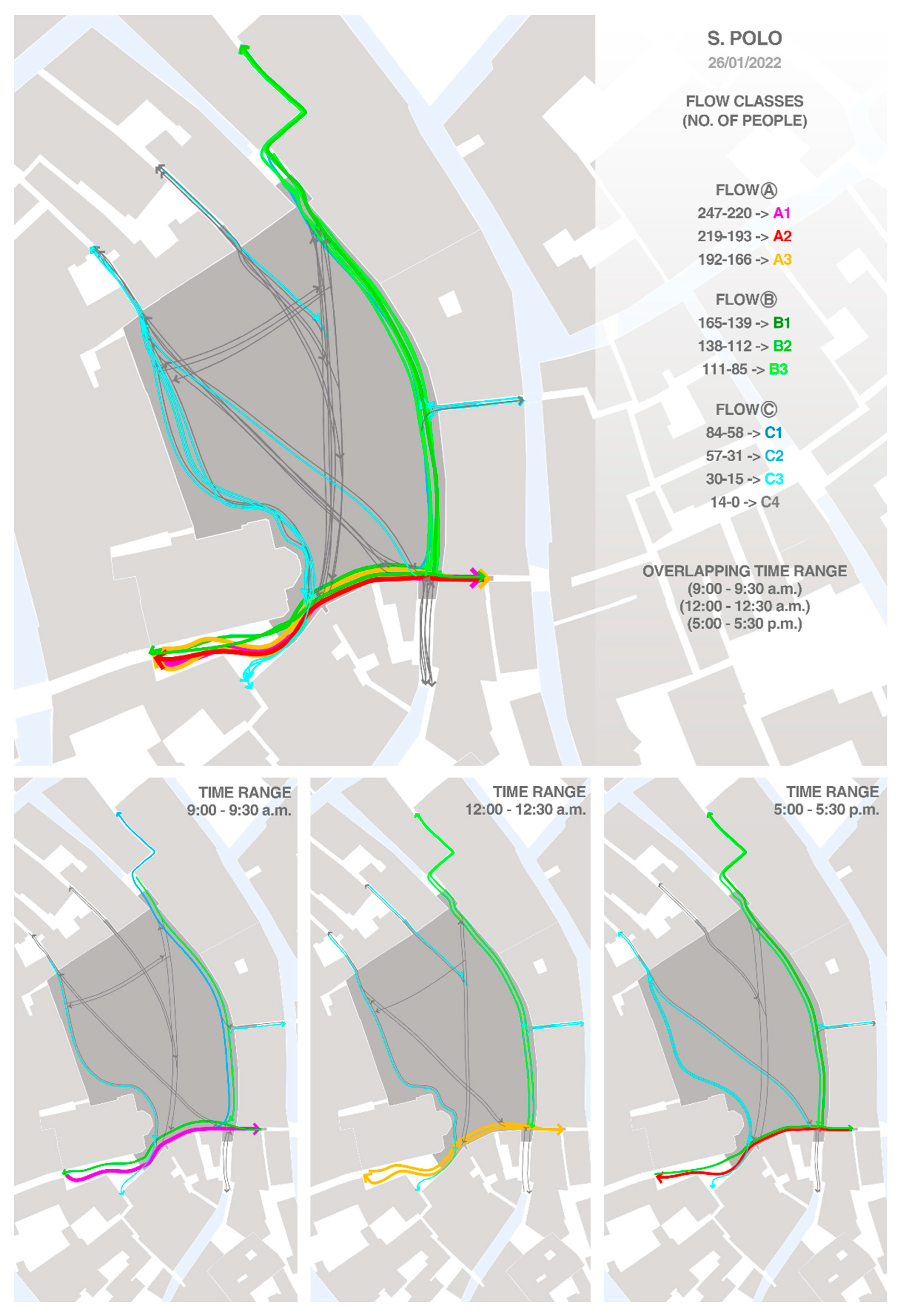
The second stage was based on the reading of the pedestrian movement flow analysis. Pedestrian flows are influenced by the physical aspects of the urban fabric, by the microclimate, and, obviously, by the human needs that generate them. They represent the precise disciplinary and methodological point of convergence of the entire analytical process, with an addition: dynamism.
Mapping the PMFs within a city is valuable for understanding urban needs, from the socio-cultural ones to the architectural-regenerative ones and the business and economic ones. The flow values of urban areas are determined by the quantity of units per hour, the hourly speed of the crossings, and their preferential direction. Data are ordered in classes (A, B, C, D) and can be compared with other contexts or analytically limited to their own contexts. Levels of nodality [
27], urbanity, and relationship are applied to these values, determining the degree of specialization, speed, and direction of a path, as summarized in
Table 1.
Our PMF mapping considered data derived from 27 January 2022, collected via surveys carried out at three time points: 09.00–09:30, 12.00–12.30, 17.00–17.30. The results have been categorized into 3 decreasing classes (A, B, C) and 10 sub-classes (A1, A2…), which were calculated based on the number of passages per direction. From Class A through to Class C, a definite hierarchy is established.
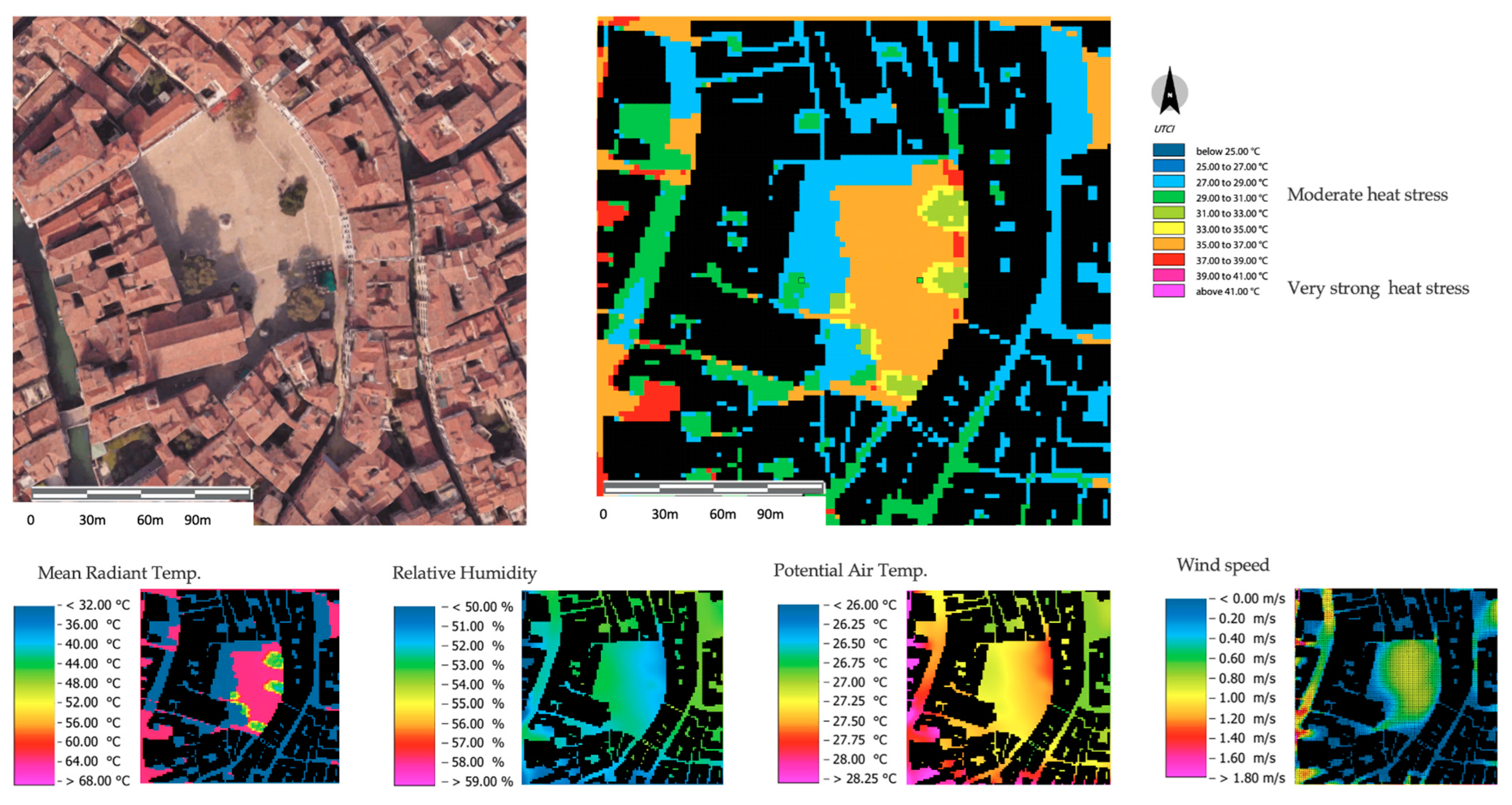
The third stage was based on assessing the local microclimate and the outdoor thermal conditions for the two selected case studies using ENVI-met software (4.4 version) [
28]. ENVI-met is the most used 3D microclimate simulation software, and it has a wide range of applications in urban planning, building design, and energy efficiency since it is able consider every climate parameter and simulate a variety of climate conditions. ENVI-met can also simulate the effects of different building materials, vegetation, and water. The tool is also used to predict the effects of urban design changes on the microclimate environment and the human thermal comfort of people in cities worldwide.
Finally, detailed neighborhood-scale microclimatic simulations were performed for both the case studies, including their urban buildings, trees, and urban finishings (as shown in
Table 2). Microclimatic simulations were performed under the current climate, for the hottest summer day (19 August), and for the year 2020 using the EPW file for Venice–Tessera. They are then evaluated for the hottest hour (4 p.m.). Some selected microclimate parameters, like the Mean Radiant Temperature (MRT), Potential Air Temperature (Pot Air T), and outdoor thermal comfort index—measured using the Universal thermal Comfort Index (UTCI) [
29,
30]—were calculated. The UTCI, defined as an equivalent temperature (°C), measures human physiological responses to the outdoor thermal environment and describes the synergistic heat exchanges between the thermal environment and the human body. Four variables are required to calculate the UTCI: a 2 m air temperature, a 2 m dew point temperature (or relative humidity), wind speed at 10 m above ground level, and Mean Radiant Temperature (MRT). Ten UTCI thermal stress categories were used to depict specific human physiological responses to the thermal environment according to an outdoor heat stress scale.
4. The Case Study: Venice’s Urban Fabrics
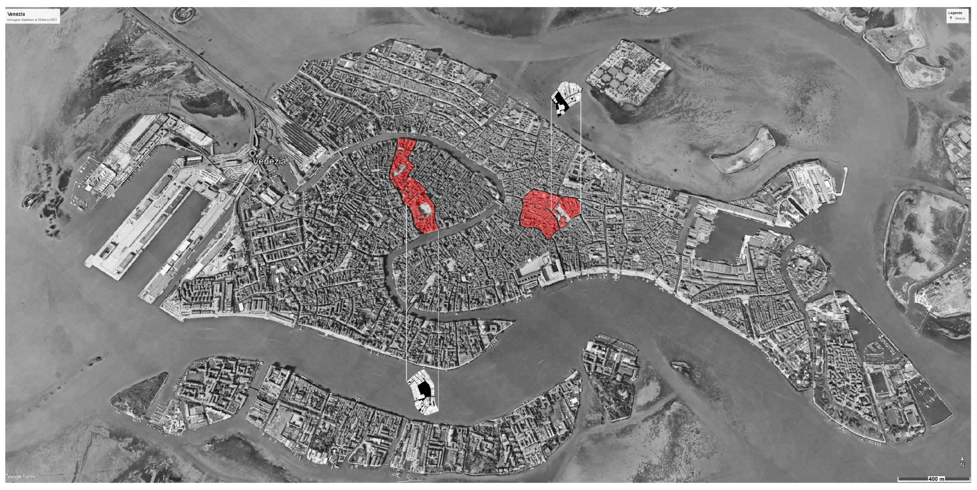
A multilayer analysis was performed at the urban scale for two selected open spaces in the city of Venice. The city of Venice, in fact, due to its pedestrianism, its historical processes, and the notable relevance of its urban structures, represents an ideal case study for the investigation of the proposed method (
Figure 1).
The Venetian urban fabric can be described through three typical settling systems [
31]:
The Quadrangular
Campo [
32] type, a typical example of post-Roman Venice till the 10th–11th century, the so-called
Archipelago city, organized by island-parishes, with clear predominance of waterways over land;
The Spine type, with water and land matrix routes put on parallel axes grafted by secondary structures placed orthogonally: Calli and courtyards. This type refers to the Gothic Venice, with a balance of values between water and land systems;
The type with fondamenta (comb) flanked by canals, with houses and collective courtyards aligned on the fondamenta. All streets are orthogonal to it. This type is typical of Renaissance-era and modern Venice (16th–19th centuries), with the gradual pre-eminence of terrestrial routes over water ones.
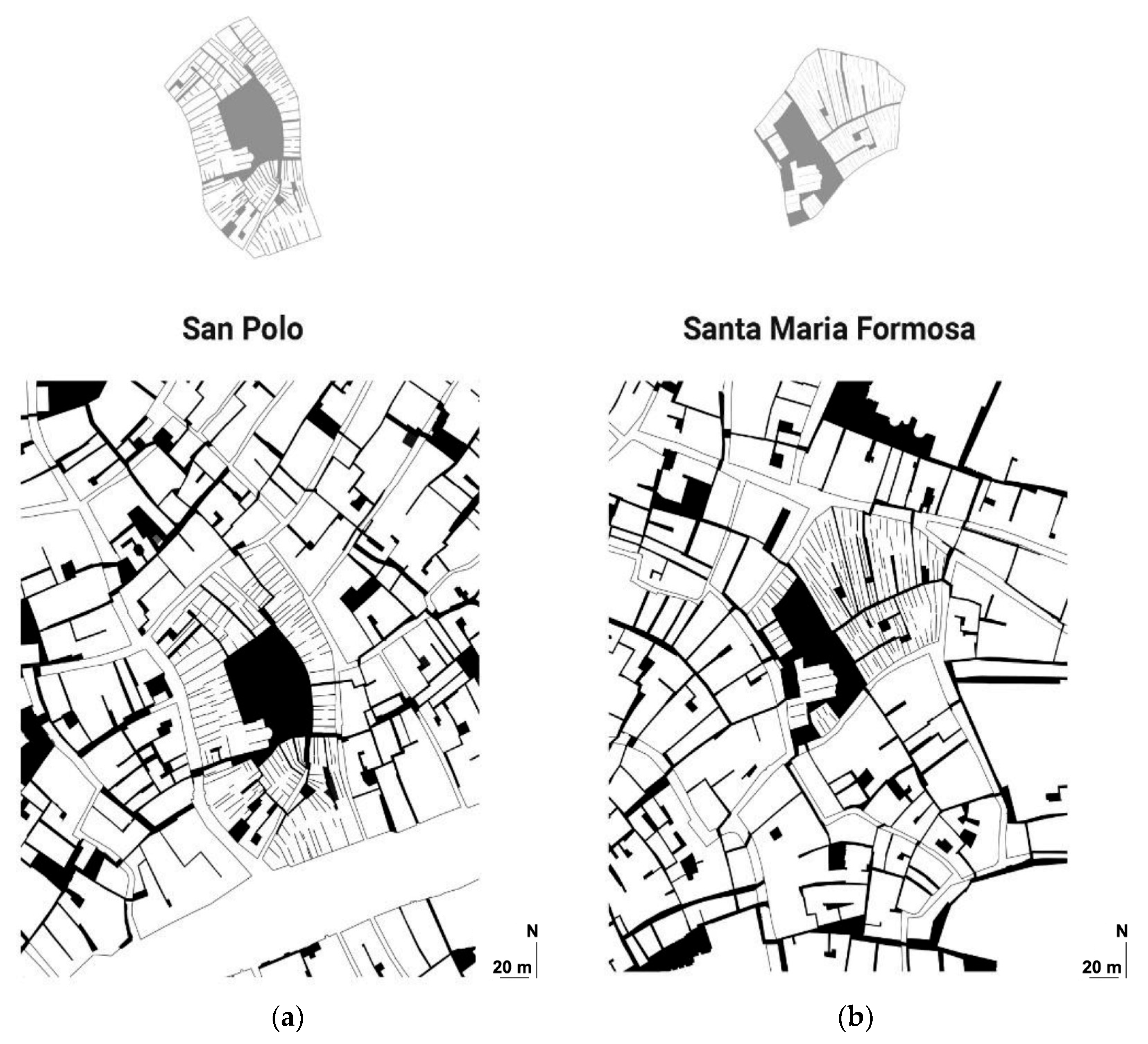
It is commonly known that only the Piazza San Marco is referred to as a piazza in Venice. The term “Campo,” is used to describe all other urban locations involving an open field. Venetian Campi are generally named after the church dominating the Campo.
The selected case studies presented herein and evaluated according to our methodology are two Venetian Campi: Campo San Polo and Campo Santa Maria Formosa (
Figure 2).
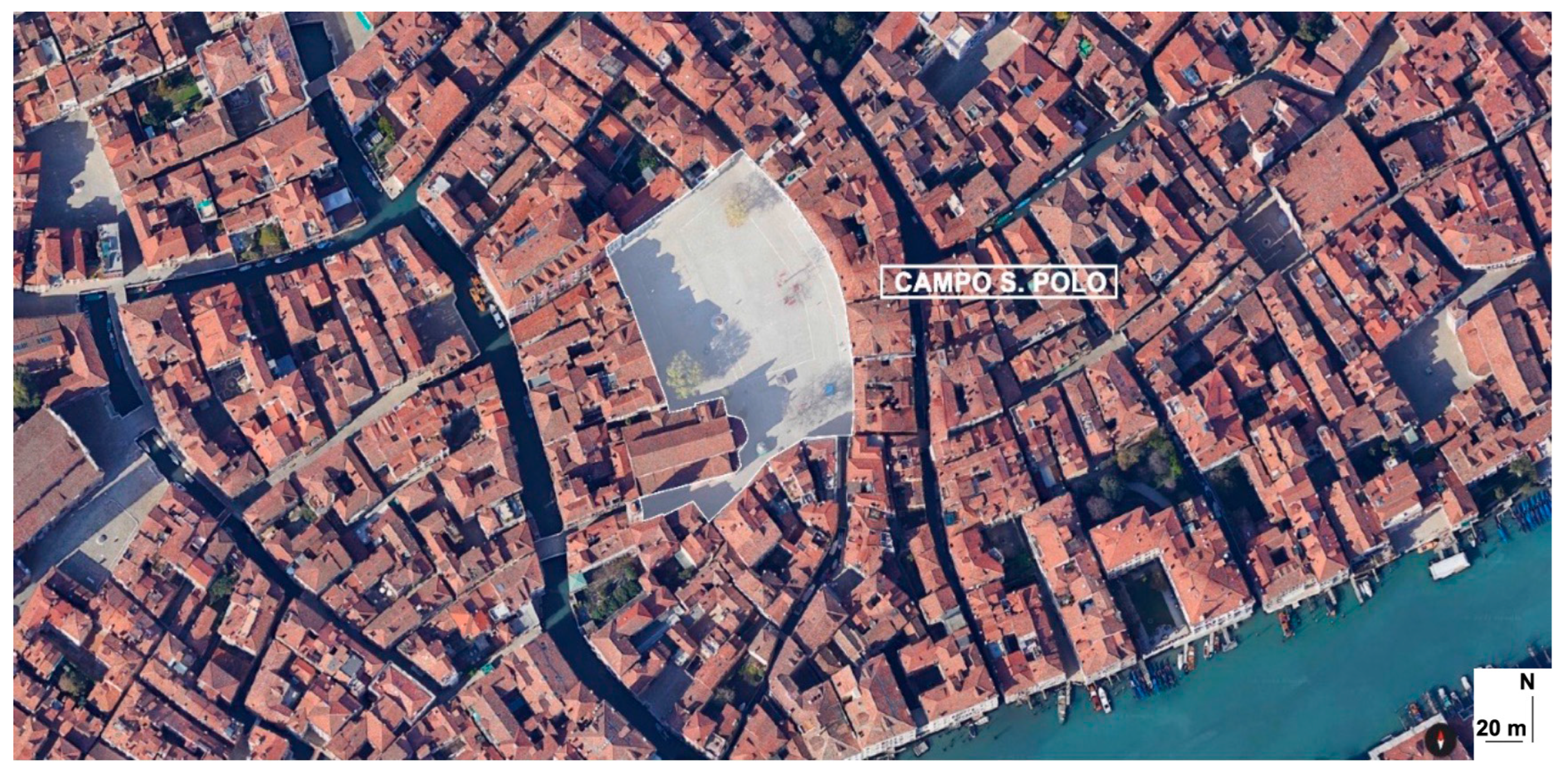
Campo San Polo (
Figure 3) is the largest
Campo in Venice and the second largest Venetian public square after the Piazza San Marco. It is in the
Sestiere San Polo and connects the Canale di Cannaregio with the San Marco districts. Campo San Polo belongs to the first type of the aforementioned typology systems (self-sufficient island-parishes). In this typology, the land systems are morphologically anti-nodal waste areas [
33].
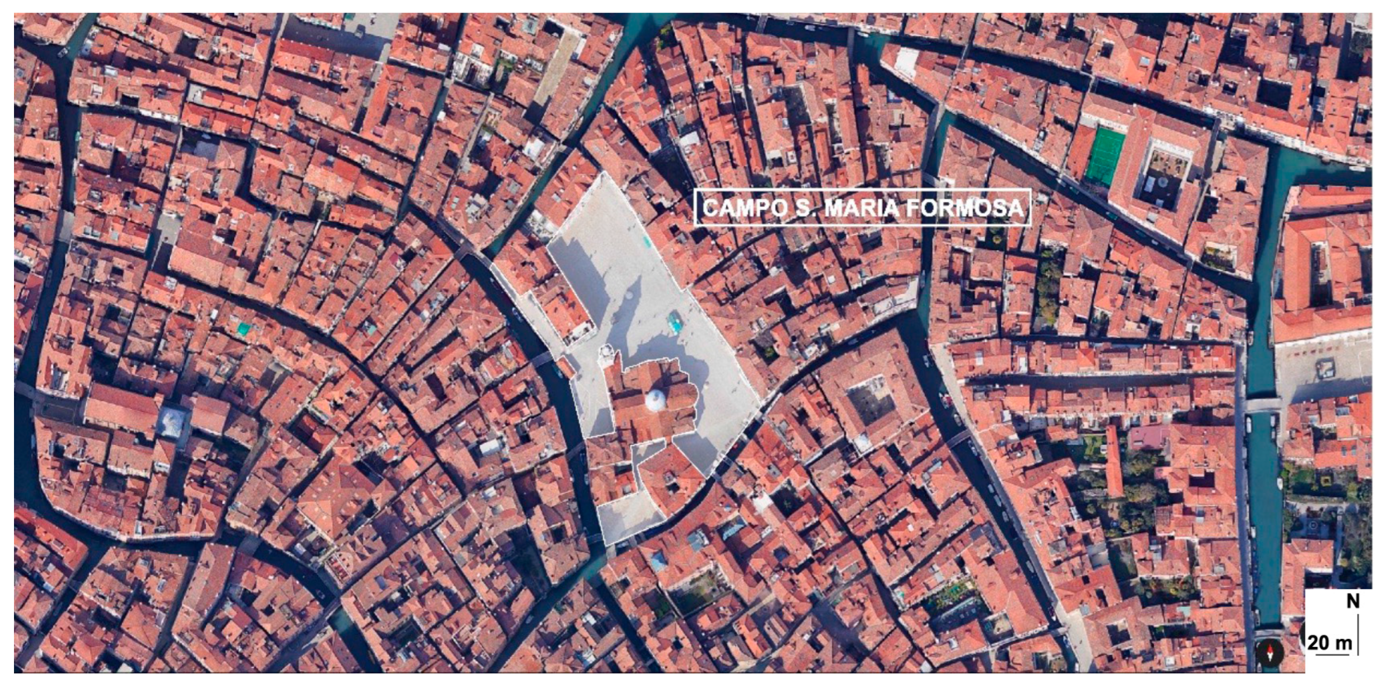
The second selected case study is Campo Santa Maria Formosa (
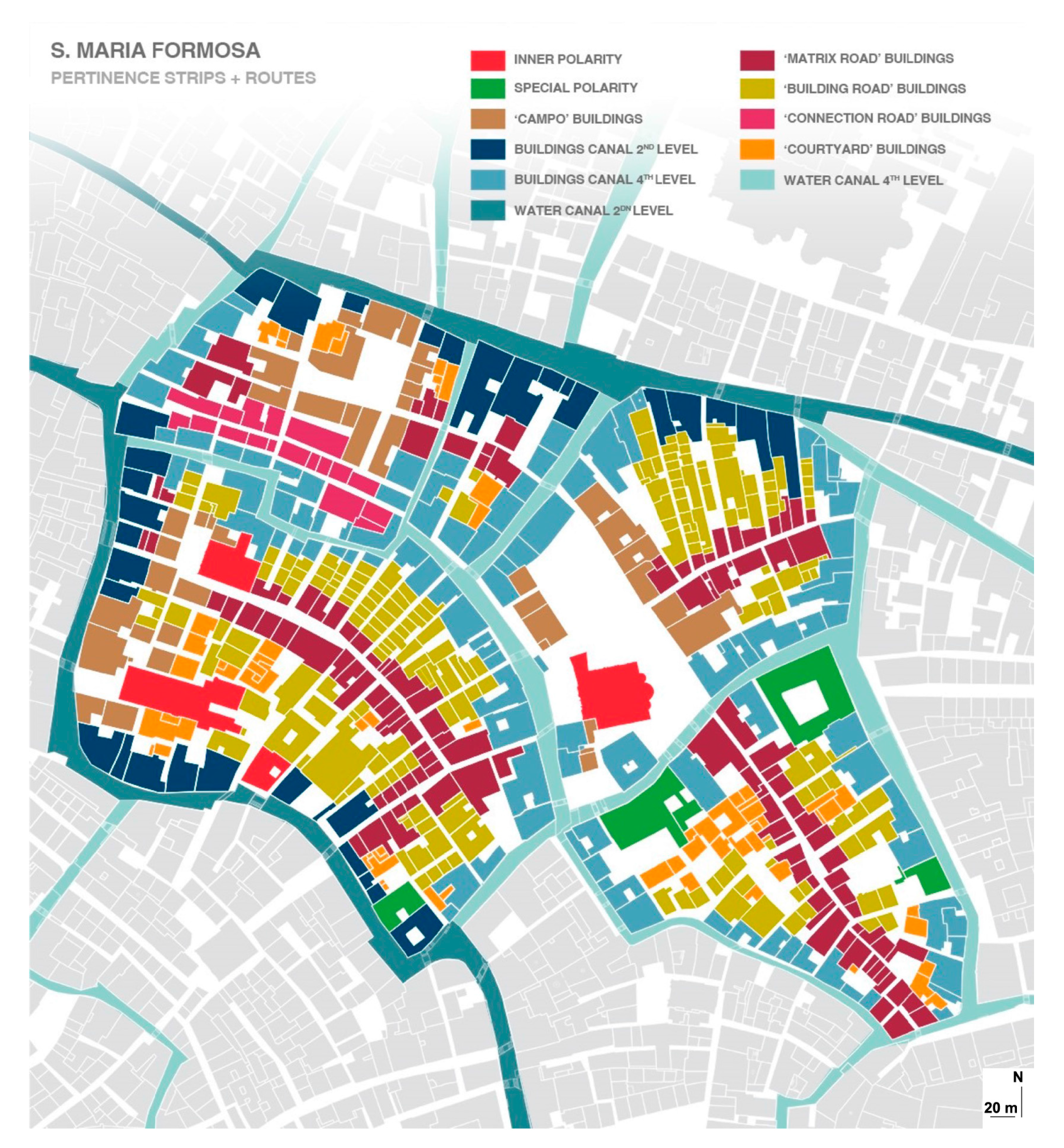
Figure 4), which is an example of an open area located in the overcrowded Castello neighborhood between Piazza San Marco and the Ponte di Rialto. The church of Santa Maria Formosa is what gave the area its name. Eleven bridges and nine distinct
Calli converge in the Campo. Santa Maria Formosa is a part of the second type of fabric, which combines both water and land routes with their corresponding pertinence strips. It is a system that is typical of Gothic Venice. It grafts onto the previous kind (Quadrangular Campo) morphologically, defining highly compact fabrics and routes with a distinct formal continuity.
5. Results
5.1. Campo San Polo
The multidisciplinary methodology (MA; step one) was first applied to Campo San Polo and its surroundings.
The need to extend the area subject to morphological investigation was due to the close functional and urban relationships that connect Campo San Polo with a dense network of other
Campi, including the following: San Zan Degolà, San Giacomo dell’Orio, and Sant’Agostino. The MA analysis aimed to identify the hierarchical structure of the routes and their pertinence strips (
Figure 5). The study of the pertinence strips demonstrates how the “Archipelago City” was settled from the Laguna to the land, with the Campo’s anti-nodal spaces remaining (exactly a “field”) for centuries. They will not adopt square-like characteristics until the end of the Gothic period, after the consolidation of the land
Spine systems. The historical hierarchy of the converging pathways in the Campo is also shown by the investigation of the pertinence strips.
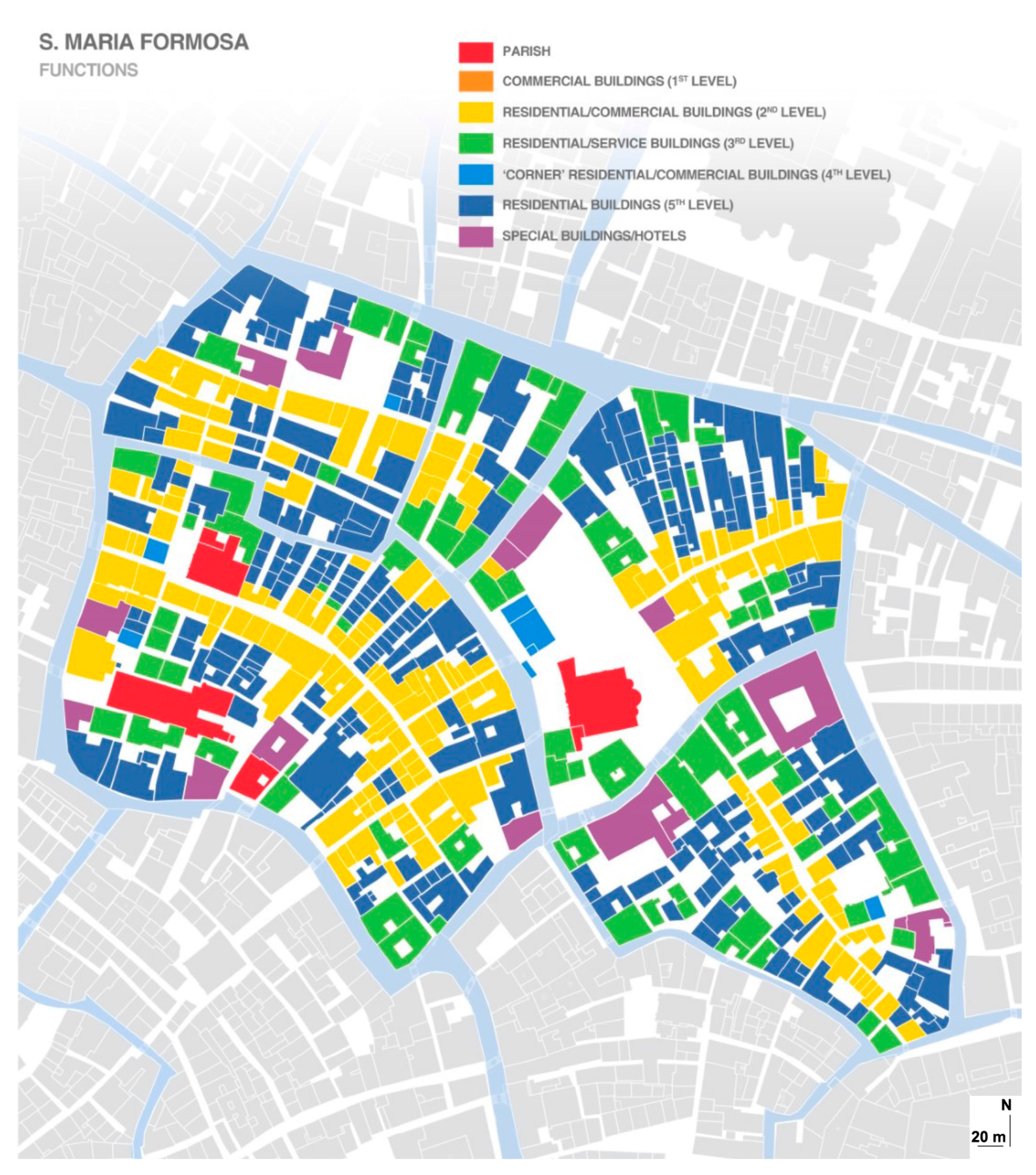
The functional analysis map shown in
Figure 6 confirms the hierarchies of the flows analysis by concentrating the less residential and the more mixed-use functions along the main routes (Matrix) and the
Campo. The survey for this map was conducted thanks to the GIS tool, reinterpreting investigation on site.
Based on the second stage of the proposed methodology, the analysis of the PMF helped identify the presence of a Matrix route built on the edge of the pertinence strip of the houses built on the
Canal Grande (
Figure 5). A second matrix was identified at the northern connection with the other islands in this part of the Venetian fabric, as illustrated in
Figure 5.
In relation to this second type of matrix route, the strongly hierarchized functions are predominantly residential, while the Campo lacks specialized functions. This confirms the anti-nodal nature of the Campo. Once the urbanization process has been completed, in fact, despite assuming the role of a “square”, serving to identify the community of San Polo, it will maintain a basic “morphological peripherality”.
The historical–typological analysis, led through the urban survey and the use of the GIS, has therefore confirmed the water genesis of the urban fabric, starting from the Canal Grande towards the San Polo Canal, while the construction of the building fronts on the
Campo became clear later, as
Figure 5 illustrates.
According to the PMF maps shown in
Figure 7, the main pedestrian flow was observed in the southern part of the Campo, along the E–W direction (A1) and W–E direction (A2). Most of the non-residential activities are located along this flow. A secondary flow was observed in the N–S and S–N directions. Few non-residential functions are displaced on the latter. Basically, no flows cross the Campo. The reasons for this include the lack of commercial activities in the area and some recent thermal distress.
Overall, through observing
Figure 5 and
Figure 6, comparing them with the GIS data (i.e., the survey of the ground floors, the historical stratification of the building walls, the position of the ground and water entrances, and the building heights), and extending the flows analysis to the other
Campi (San Zan Degolà, San Giacomo dell’Orio, Sant’Agostino), it can be observed how a series of highly hierarchized paths come off the Matrix routes and the canal system (also hierarchical), giving us a sequence of
Campi that are still strongly anti-nodal. None of them function as a real urban “square”, maintaining a strongly local role.
In accordance with stage three of the methodology, an EA of
Campo San Polo, performed using ENVI-met software, was conducted to gauge the relationship between heat stress and the outdoor livability of San Polo. The UTCI values represented in
Figure 8 reveal that San Polo is characterized by heat stress near the facades of buildings; the shaded areas in the figure represent areas with lower MRT values.
Due to the lack of shade and the existence of impermeable surfaces that exacerbate the thermal discomfort, there is high heat stress amid the Campo.
Only locations under the canopy of trees, where evapotranspiration and shade are particularly efficient, are acceptable for the Pot Air T (
Figure 8). The UTCI values indicate some thermal stress brought on by extreme heat and humidity, which has a significant impact on how the Campo is used, particularly in the middle where UTCI values approach 35 °C UTCI. Therefore, to improve the use of urban space, both in terms of crossing and remaining, interventions to maximize the Campo’s shaded spaces are required. The findings of the wind simulation throughout the examined day revealed a variation in wind velocity.
The findings of the wind simulation conducted on the observed day showed a variance in wind speed of up to 0.6 m/s (0.2 and 0.2 m/s, respectively) between the Campo’s interior and its outskirts. This can be explained by the absence of air channels that would allow the wind to pass through and leave the Campo.
However, with the integration of the evaluation tools employed, Campo San Polo’s environmental and urban improvement strategies can be advantageous. The introduction of non-residential functions along the western side of the Campo, where most of the late buildings and easily modifiable typologies are located, would strengthen the second Matrix route on a functional and morphological level and encourage more people to use the Campo.
The mitigation of environmental critical issues, by the insertion of trees along the secondary matrix path and partially in the center of the Campo, would then allow wider use of the public space, favoring crossing paths and rest areas.
5.2. Campo Santa Maria Formosa
The MA demonstrates that Campo Santa Maria Formosa is organized as a “spine” on a central Matrix route in line with methodology stage one. Four land “Spine” networks converge in Santa Maria Formosa, and four major routes from San Zaccaria, San Marco, Rialto, and Fondamenta Nove contribute to the city’s high nodality value. A robust network of waterways also functions as an opposing force to the land system.
The study of the Pertinence Strips supports the transition of the “Archipelago City” from the water to the land, where the Campo has persisted as an anti-nodal region (a “field”) for centuries. The characteristics of a square were not be adopted until later (Gothic Venice), with the consolidation of the land “Spine” systems.
The parish church entrance faces the canal, giving its secondary facade to the Campo. The examination of the Pertinence Strips demonstrates the historical hierarchy of the Campo’s converging paths.
The functional analysis map focuses on the less residential and more mixed-use functions along the major route (Matrix) and the Campo, which supports the flow analysis’s hierarchy. According to the study of the corresponding pertinence strips, there is a significant integration between the tissues produced on the canals and those constructed using Matrix pathways. The latter is distinguished by the development of buildings orthogonally to the matrix route, primarily through streets and communal courtyards bordered by terraced and pseudo-terraced homes. The Campo Santa Maria Formosa is then completed and defined as a genuine square, as seen in
Figure 9 and
Figure 10.
Once again, the parish church turns its back on the Campo highlighting its “anti-nodal” role within the city of the early centuries. Once again it opens onto the canal, originally, of greater importance.
All non-residential activities are concentrated, along the Matrix route and around the Campo, leaving the ancient water systems a purely residential and anti-nodal role.
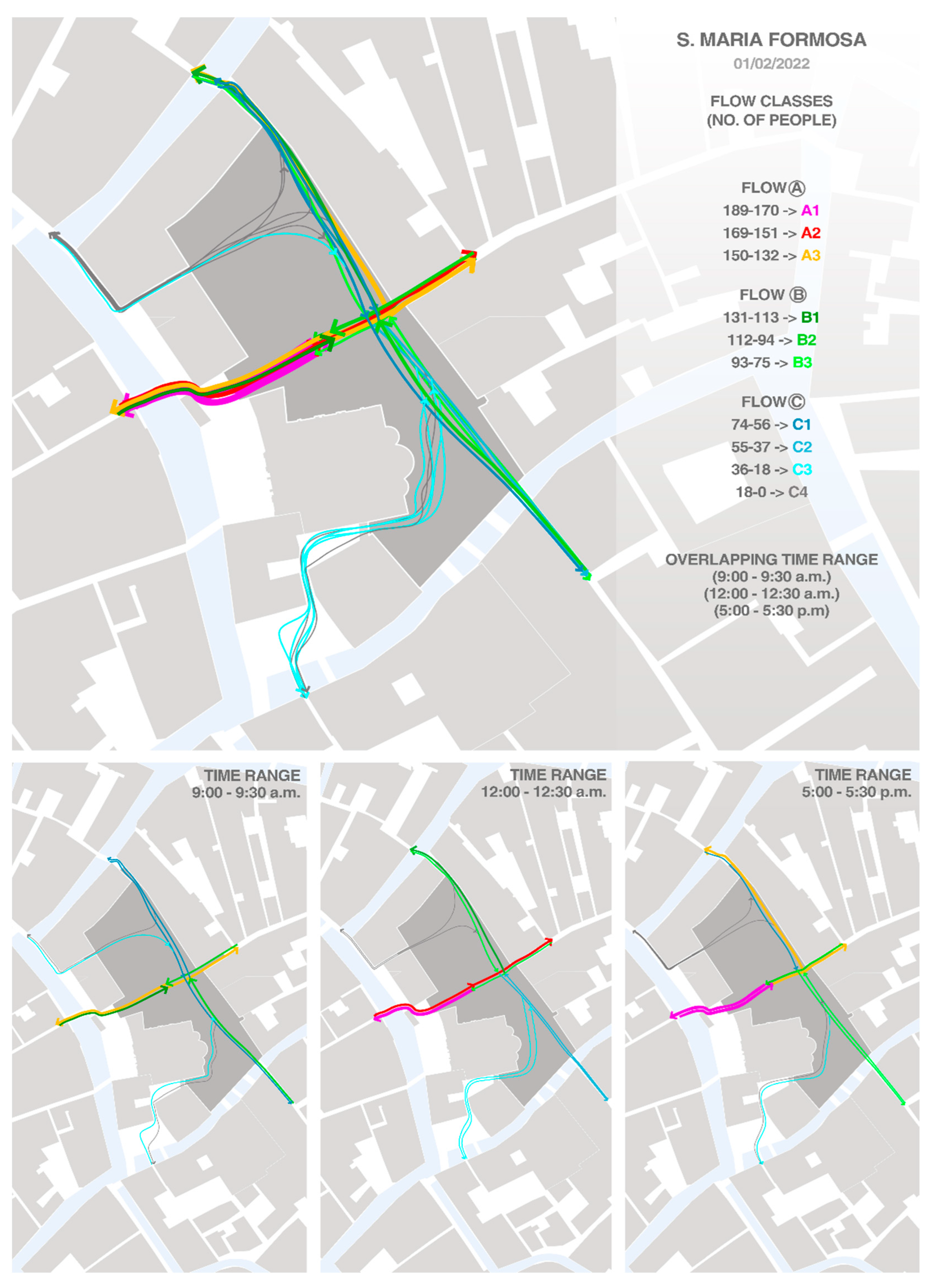
The PMF maps (stage three) contributes to giving a clear hierarchy among these settling systems and paths, as in
Figure 11.
For most of the day, the main flow (A1) enters the public area from the W side and proceeds to the center. Up to Fondamenta Nove, the northern edge of the Venetian urban fabric is reached by a second main flow (A2). A fourth-level flow runs down South towards San Zaccaria while a third-level flow (B1) runs to the N-W. The hierarchy between the four neighborhoods and the four pathways is thus obvious. Campo Santa Maria Formosa is itself a matrix of the main flow up and down with San Marco due to its highly nodal value. It is also one of the “gates” leading from the north into the city center.
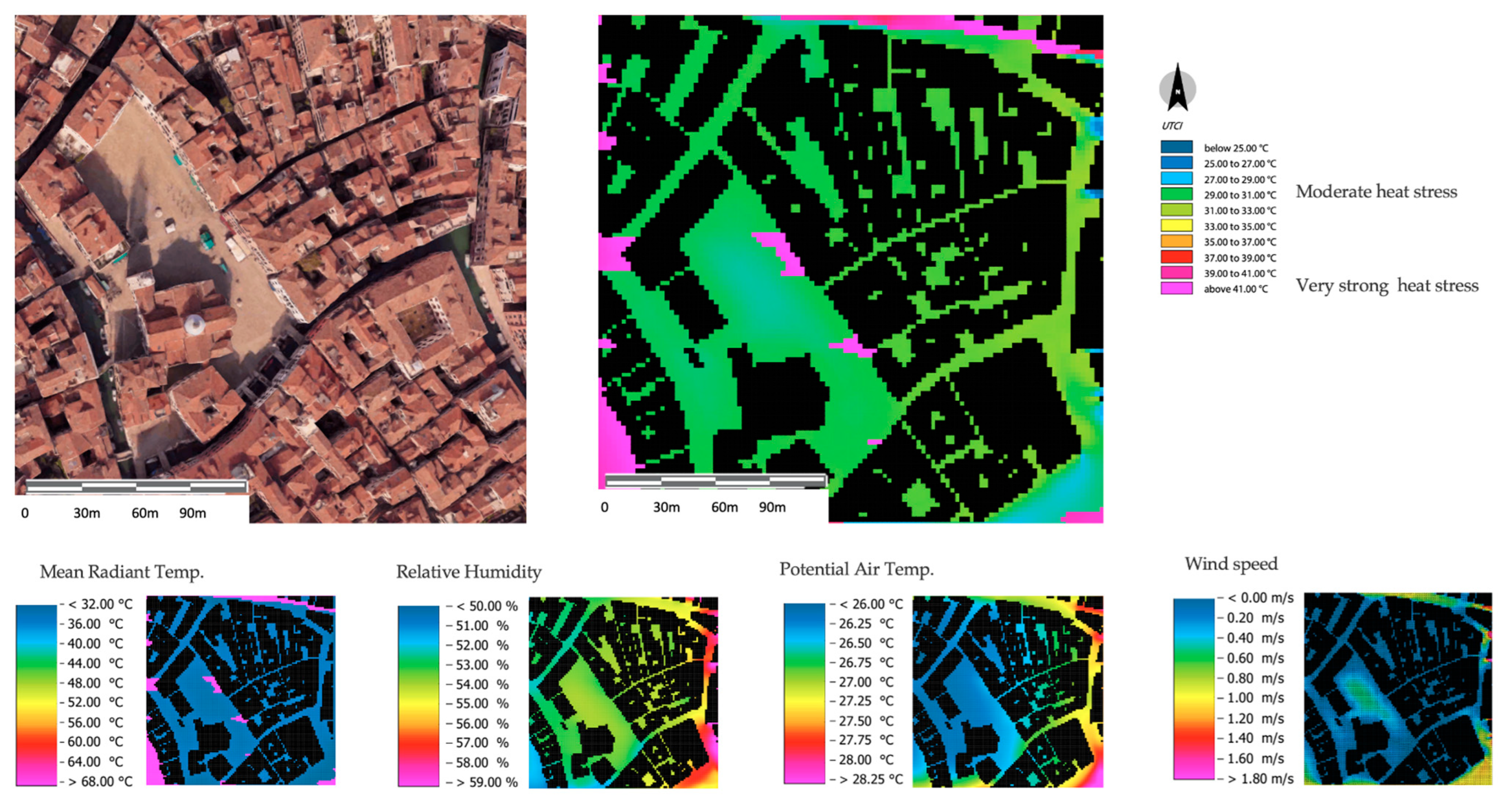
Finally, step 3 is completed, and EA maps are displayed in
Figure 12. From a microclimatic perspective, the integration of water and land systems provides limited possibility for the development of large empty urban spaces. The dense network of
Calli and canals, in fact, allows for substantial thermal neutrality in terms of temperature, relative humidity, and wind speed during summertime and some criticalities in wintertime due to excessive shading and poor ventilation, as reported in UTCI value maps in
Figure 12 (apart from the Campo, whose microclimatic behavior offers acceptable conditions for outdoor comfort in the summer months due to moderate heat stress, as in
Figure 12). The UTCI values show some thermal stress due to excessive heat and humidity, that strongly influence the use of the
Campo. The density of the tissue and its orientation supports an overall acceptable outdoor comfort in the summer, nevertheless some criticalities can be detected in other parameters.
In comparison to San Polo, Santa Maria Formosa is much more expansive. From 1 p.m., the facades of the buildings here, along with the church’s apsidal section, provide more shade. The center of Santa Maria Formosa reflects low stress compared to the neighboring dense urban texture, where tiny streets and courtyards give more shady zones.
The canal on the left is barely there in this Campo. By modifying the urban fabric punctually following the matrix pathways and the prevailing winds, potential interventions to reduce heat stress may be attained.
6. Discussion
In the two selected Venice Campi, the analysis tools used—UM analysis, PMF analysis, and EA analysis—showed clear similarities in identifying the places most likely to be appreciated and used by people.
The most comfortable open spaces, from an urban point of view, include the pedestrian flows, and those that offer a wider thermal acceptability are those that offer the wider shaded areas, those that are closer to building facades, those where shops, cafés, and other commercial buildings are hosted, and those where the presence of the urban fronts offers more protection. These reliable data support the idea that users do not necessarily choose the most direct route to reach their destination if it is characterized by evident thermal stress conditions; instead, they choose the most advantageous (formally functional and environmentally functional) path.
Even though the comparative analyses conducted on the two areas in Venice come from various disciplinary domains, the congruence of the data acquired from the three disciplines exhibit a high degree of comparability. The cases of Campo S. Polo and Santa Maria Formosa are typical, as already mentioned. Although the shortest routes could be the most preferable in terms of user practicability, no diagonal Campo-crossing flows have been found in any scenario. This is primarily caused by the obvious temperature stress of the outdoors and the ensuing functional and formal deficits. Instead, the highest flows were seen around open, dynamic facades, areas hosting commercial activities, and wider shaded spaces, because these locations provide longer but superior paths (from an experiential standpoint).
In other words, the concentration of non-residential activity is where pedestrian flows are quantitatively higher and where the resulting nodality values are higher. More comfortable thermal conditions and improved façade preservation are both benefits. Overall, the general livability of cities can be defined based on each of those areas.
Moreover, the mapping of pedestrian flows (
Figure 7 and
Figure 11) illustrated the social and dynamic facts of urban morphology. The flows are mapped in real-time for every day of the year, giving information about how people use the city and public spaces. Pertinence strips (as seen in
Figure 5 and
Figure 9) are used to express the physical–material information of urban morphology and give structure to the public space. The building volumes that surround an urban public space really shape it.
7. Conclusions
The approach described in this study aims to define the similarity of the data obtained from UM, PMF, and EA analyses, as well as how they can be incorporated into a holistic evaluation of urban outdoor open areas. The findings for the two urban open spaces used as case studies for our research give support to the core research hypothesis that the three stages provide reliable and comparable outcomes.
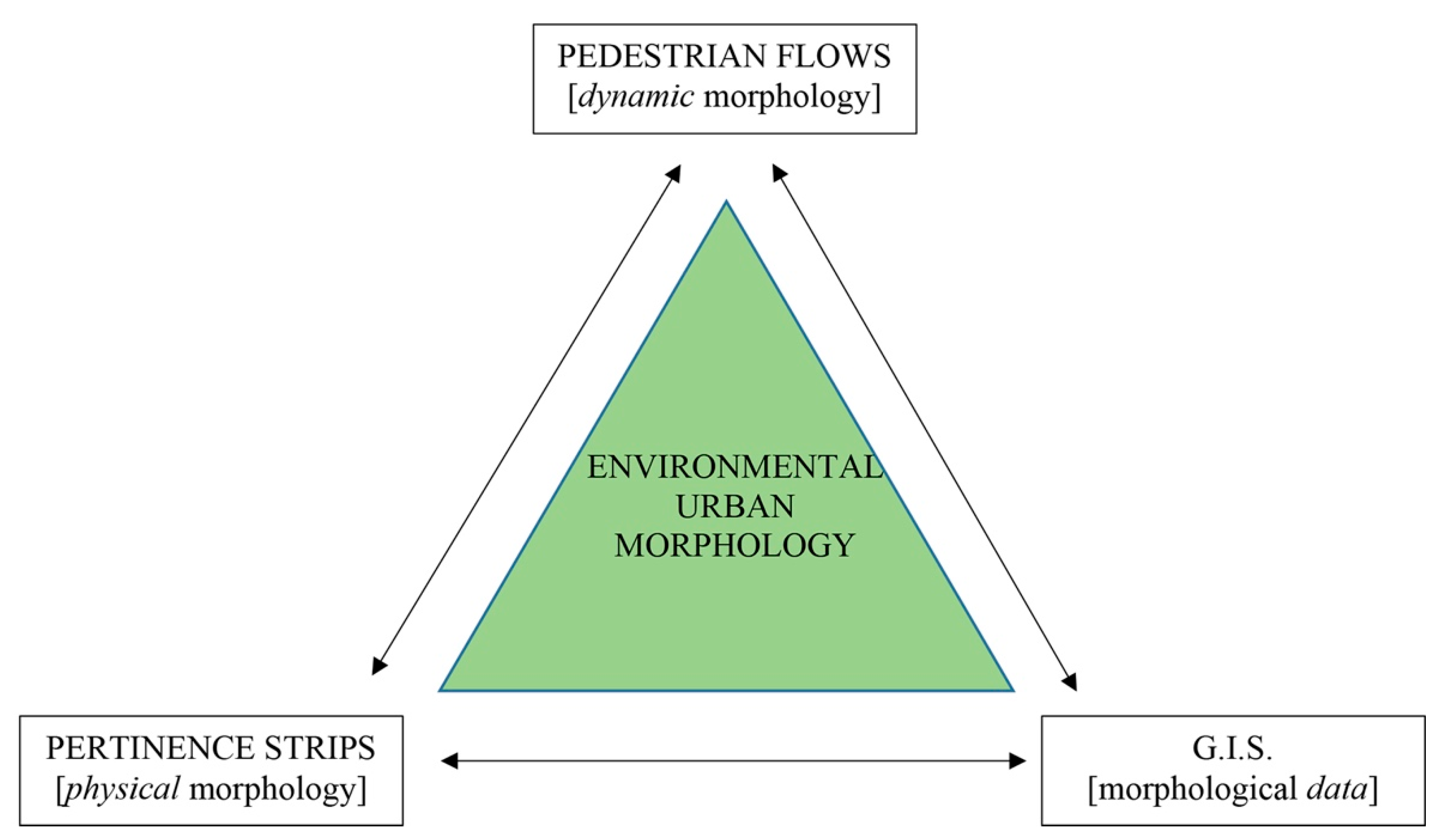
This paper is part of a wider ongoing study that aims to evidence the existence of a direct link between morphological and urban features, human behaviors, and environmental thermal stress. Even though the tools they rely on are very different, the synchronized readings of metropolitan maps, pedestrian movement flow maps, and environmental comfort maps reveal shared evidence (
Figure 13).
Pertinence strips, which stand in for the “physical city”, represent the setting in which all human activities take place, whether privately inside of buildings or publicly in open areas.
Furthermore, flows tell us about how citizens make use of public areas. “The way through which citizens use the public space is the mirror of how they experience the city” [
34]. They take place within the spaces of the physical city, and they are directly correlated with the data of the lived city.
Finally, environmental analysis, with a particular emphasis on microclimate evaluation, represents the natural context that influences the microclimatic and energy-related value of the urban texture and influences the thermal comfort of those residing in the immediate area. The physical form of urban fabrics is influenced by the microclimatic characteristics of open spaces, as well as the microclimatic features of the open spaces’ influence on pedestrian flows.
Increasing pedestrian flows, improving the level of connectivity with the surrounding nodal conditions, and supporting outdoor thermal conditions increases the attractiveness of places and enhances an area’s most valuable urban features, both physical–material and social–economic.
As a result of combining the aforementioned analyses instruments into one tool, the development of a new dynamic, multilayer, and multidisciplinary methodology for the analysis of urban fabrics—Environmental Urban Morphology (EUM)—has been proposed.
In conclusion, this methodology could contribute to better informing urban planning, urban design, and urban redevelopment, especially with regard to dense and compact urban fabrics, supporting architects, practitioners, and local municipalities in constructing specific and targeted interventions that account for citizens’ livability needs, thermal- and climate-based actions while also considering the most used urban areas.
These theoretical assumptions may need to be confirmed and evaluated in a variety of urban textures and in a variety of historical contexts to appraise the methodology’s applicability and reliability, and it is worth highlighting that some more on-site monitoring is expected to be carried out to validate the integrated approach and validate the microclimatic data, along with the morphological assessments.


 ,
, 


