Proceeding Paper

Long-Term Dynamics of the Thermal State of Technogenic Plots in Siberia Based on Satellite Data †

by
Tatiana Ponomareva
1,2,*,
Nikita Yakimov
2,3,
Georgy Ponomarev
4 and
Evgenii Ponomarev
1,2,3
1
V.N. Sukachev Institute of Forest, Siberian Branch, Russian Academy of Sciences, 660036 Krasnoyarsk, Russia
2
Department of Ecology and Environment, Siberian Federal University, 660041 Krasnoyarsk, Russia
3
Federal Research Center “Krasnoyarsk Science Center, Siberian Branch, Russian Academy of Sciences”, 50/45, Akademgorodok, 660036 Krasnoyarsk, Russia
4
Department of Geology and Geophysics, Novosibirsk State University, 1, Pirogova Str., 630090 Novosibirsk, Russia
*
Author to whom correspondence should be addressed.
Presented at the 3rd International Electronic Conference on Forests—Exploring New Discoveries and New Directions in Forests, 15–31 October 2022; Available online: https://iecf2022.sciforum.net/.
Environ. Sci. Proc. 2022, 22(1), 49; https://doi.org/10.3390/IECF2022-13081
Published: 21 October 2022

Abstract

:
We studied the dynamics of relative anomalies (ΔT/Tbg) in the ground cover thermal regime of technogenic territories in Siberia under the conditions of gold mining impact. The impact of gold deposit mining determines the change in the thermal state of the post-technogenic plots for a long time, which is an important feature of ecosystem stability monitoring. We analyzed the spectral characteristics of four technogenic sites that had gold mining quarries of different age. We evaluated the stages of technogenic plots according to the initial level of thermal anomaly, the rate of decrease in thermal anomaly, the time of stabilization recovery processes, and dispersing of the residual level of thermal anomaly.

1. Introduction

In the boreal zone all over the world [1], including in Siberia, vegetation and soils are disturbed over large areas [2,3]. These disturbances are associated both with natural causes, such as forest fires [4,5,6], and anthropogenic impact [7,8]. The most significant factor is the impact of the industrial/mining complex [3,9,10].
Detailing the characteristics of disturbed plots allows for predicting the rate and success of post-technogenic recovery. The vegetation index, proposed by Rouse et al. in 1973, is widely used for monitoring of the vegetation state [11,12]. The most famous vegetation index is the Normalized Difference Vegetation Index (NDVI) [13].
However, post-technogenic plots are always accompanied by a change in the thermal regime of the surface, caused by a decrease in the surface albedo and a change in the heat-insulating properties of the soil and on-ground vegetation [8,14,15]. Abnormal heating of the surface and upper layers of soil persists for a long time (up to 20–40 years), depending on the degree of disturbance and the type of reclamation [16]. Under these conditions, we suggested remote monitoring vegetation restoration by the long-term loss of temperature anomalies in disturbed plots [17,18].
Currently, we have investigated the temperature anomalies of goal mining plots that had mining quarries of different age. We evaluated the stages of technogenic plots according to the initial level of thermal anomaly, the rate of decrease in thermal anomaly, the time of stabilization recovery processes, and dispersing of the residual level of thermal anomaly.

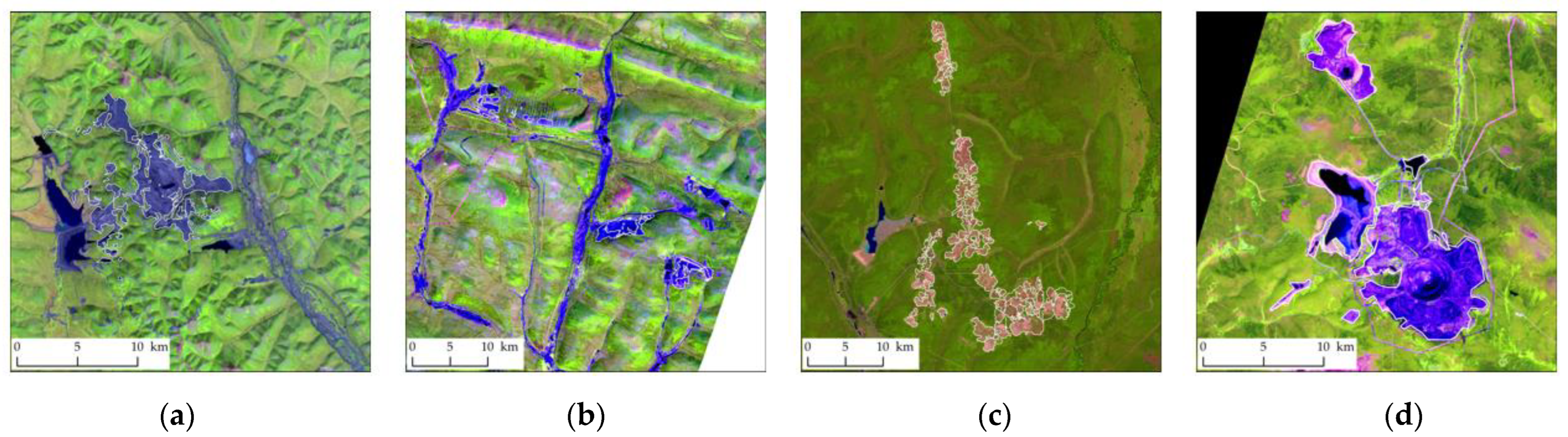
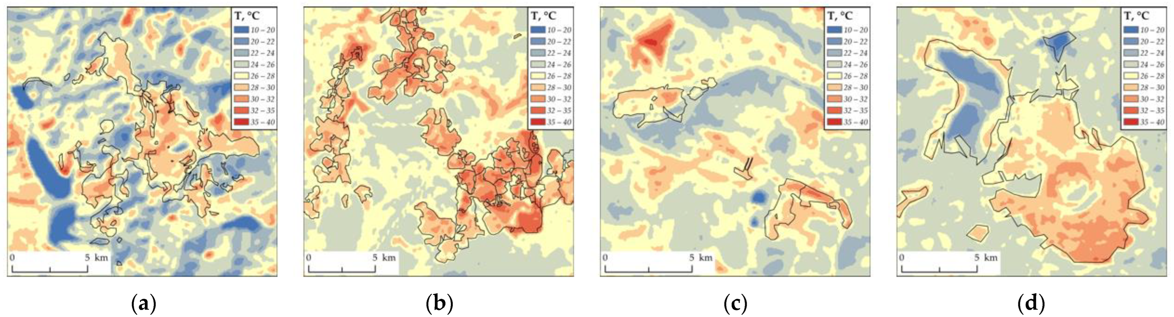
2. Material and Methods

We studied four post-technogenic sites located in the taiga zone of central Siberia, Russia. The identified objects of study are areas of industrial gold mining of different ages (Figure 1). The plot of the Natalka mining plant (NMP) is placed in the Magadan Region and has been in active stage since 1990. In the Irkutsk Region, the plot of the Verninskoye mining plant (VMP) has been in active stage since 2011. The oldest plot of the Kuranakh mining plant (KMP) in the Republic of Sakha (Yakutia) has been in active stage since 1965. The plot of the Olimpiada mining plant (OMP) has been in active stage since 1990 in the Krasnoyarsk Region. Additional information about the studied objects is in the public domain (https://polyus.com/ru/operations/operating_mines/, accessed on 14 October 2022). The peculiarity of the selected technogenic plots is that these are rock dumps, where on-ground cover and soil structure are destroyed. Recovery processes (for vegetation cover and soil structure/characteristics) in such plots are much slower than in other post-technogenic areas.
These plots are located in the East Siberian taiga–permafrost forest sub-region. In this territory, the main species forming stands are larch (Larix sibirica, L. gmelinii) and pine (Pinus sylvestris), which cover up to 55% and 18% of the region [6]. The remaining forest-forming species (Pinus sibirica, Abies sibirica, Picea obovata, Betula spp., Populus tremula) and tundra vegetation make up ~25–27% of the study area [6].
The soil cover is represented by zonal soils (see Table 1) in non-disturbed territories. (soils classified according to World Reference Base (WRB) 2014, https://www.fao.org/3/i3794en/I3794en.pdf, accessed on 14 October 2022). However, technogenic surface formations (Technosol (TC)) and anthropogenic transformed types of zonal soils (Anthrosols (AT)) are typical for the disturbed areas here.
We analyzed the long-term dynamics of spectral characteristics and summer temperature fields for each technogenic plot (Figure 1) from satellite data for 1973–2020. We used images from Landsat 8/OLI/TIRS (Operational Land Imager/Thermal Infrared Sensor), Landsat 7 ETM (Enhanced Thematic Mapper), Landsat 4-5 TM (Thematic Mapper), and Landsat 1 MSS (Multispectral Scanner System) (USGS, https://earthexplorer.usgs.gov/, accessed on 20 July 2022). The spatial resolution is 30 m for data from OLI and is 100 m for temperature data from TIRS. For each disturbed plot, combinations of channels #5-4-3 for Landsat-4/5/7 and channels #6-5-4 for Landsat-8 were used. Finally, we used data for 1973, 1986, 1990, 2000, 2005, 2010, 2015, and 2020.
Based on standard calibration procedure, we evaluated and averaged the surface temperature (B6, B6/2 channels of λ = 10.4–12.5 μm, Landsat-5,7/TM/ETM and B10 channel of λ = 10.6–11.19 μm, Landsat-8/OLI).
We evaluated temperature fields for the selected technogenic plots (Figure 1 and Figure 2). Next, we analyzed thermal fields of each plot, comparing to temperature of non-disturbed territories (background thermal values) during the summer period (ΔT/Tbg, °C/°C):
ΔT/Tbg = 100% × (Ttg − Tbg)/Tbg,
where Ttg is the surface temperature of the target (disturbed area), °C, and Tbg is the surface temperature of the background (neighbor non-disturbed territory), °C.
The background temperature was determined from measurements inside the areas closest to the disturbance zone. The background temperature was averaged over 1000–3900 values measured inside polygons with areas of 0.25 × 10³–1.0 × 10³ ha. Within the disturbed areas, a threshold criterion (Ttg < 15 °C) was additionally used to exclude temperatures in pixels related to technical water bodies, present in some disturbed areas (Figure 2d), from further averaging. Thermal fields were evaluated for 1990–2020 with 5-year intervals.

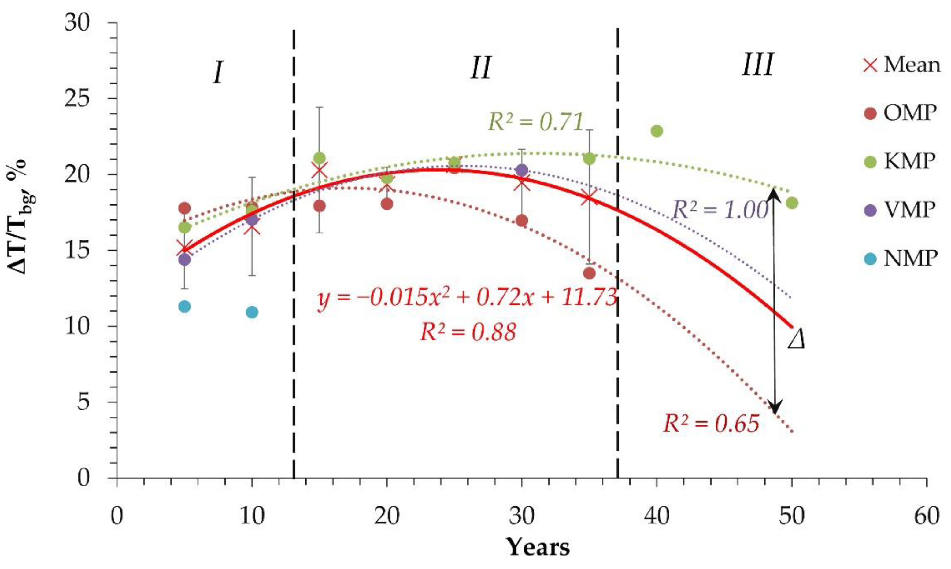
3. Results and Discussion

Disturbed areas of technogenic plots are characterized by a significant change in the summer thermal regime in comparison to non-disturbed background territory. Long-term temperature anomalies (ΔT/Tbg) in disturbed areas were evaluated for 1990–2020 per 5-year intervals (Figure 2). The average temperature was 10–25% higher in disturbed areas than in the non-disturbed background (Figure 3). The same effect was evaluated for temperature anomalies detected in post-fire plots and in technogenic plots of coal mining [16].
According to thermal anomaly values (ΔT/Tbg), we marked out (Figure 3) three stages of technogenic plots functioning during 50 years. These are the initial stages of technogenic impact (I) during the first 10–12 years, the stage of technogenic activity (II) during the next 35 years, and the post-technogenic recovery stage (III), which starts at 35–40 years.
During stage I, the formation of a technogenic territory began. Therefore, the increase in the values of the thermal anomaly is determined by the increase in the area of disturbance.
In stage II, there is a long-term technogenic impact, which significantly affects the ground cover and soils of disturbed areas. Under these conditions, the values of the thermal anomaly (ΔT/Tbg) are smoothed out, and the dispersion tends to a minimal value, which indicates the same state for all variants of studied objects in this stage. However, this stage is unique for technogenic objects of open pit gold mining. Identified objects of study are areas of industrial gold mining where on-ground cover and soil structure have been destroyed completely as the result of initial technogenic impact and further technogenic activity. Under such conditions, restoration of soil and vegetation cover is very difficult, and the start of the recovery process is delayed for 35–40 years.
By the time of stage III, post-technogenic recovery begins by reducing the technogenic impact. At this stage, it is expected to reduce the thermal anomaly to 7–10% above the background norm. Previously, we showed that stage III is typical for other variants of disturbed areas with a long-term restoration process, such as post-technogenic plots and post-fire plots, as well [16,17,18]. However, in post-fire areas, recovery processes are recorded immediately after a fire [7]. The same is true under the conditions of minor technogenic impacts or after the reclamation of disturbed areas [18].
We found that the initial level of thermal anomaly varies in the range of 10–30%, with an average value of ~15%. The highest level of the initial anomaly was recorded for the OMP plot (ΔT/Tbg ~ 30%). The smallest anomaly was recorded for the NMP plot (ΔT/Tbg ~10%). The anomaly leveling process probably stabilized at a level of ΔT/Tbg ~16–20% during stage II.
Thus, during that entire time (20–40 years), thermal anomalies affect both the state of vegetation [2,19] and the microbial community [14,15]. Further, it is possible to predict the processes associated with this effect, which may be most significant in the permafrost zone of Siberia, where additional heating of the soil profile determines the annual dynamics of the permafrost level, as the most important factor in the existence of northern ecosystems [16].

4. Conclusions

The considered plots of gold mining are a unique case of technogenic disturbance, in which there is a long-term (up to 40–50 years) absence of recovery processes. Thus, the efficiency of such processes is significantly lower in comparison with post-technogenic areas of coal mining and post-fire areas, where a significant recovery of the thermal anomaly (ΔT/Tbg) is already observed during the first 20 years.

Author Contributions

Conceptualization, T.P.; methodology, T.P. and E.P.; software, E.P. and N.Y.; validation, E.P., N.Y., and G.P.; formal analysis, T.P.; investigation, E.P., N.Y.; resources, N.Y. and G.P.; data curation, T.P.; writing—original draft preparation, T.P., E.P., N.Y., and G.P.; writing—review and editing, E.P.; visualization, N.Y. and E.P.; supervision, T.P.; project administration, T.P.; funding acquisition, T.P. All authors have read and agreed to the published version of the manuscript.

Funding

This study was performed using the subject of project no. 0287-2021-0010 (IF SB RAS) and no. 0287-2021-0040 (KSC SB RAS).

Institutional Review Board Statement

Not applicable.

Informed Consent Statement

Not applicable.

Data Availability Statement

Publicly available datasets were analyzed in this study. These data can be found here: http://pro-vega.ru/maps/ (accessed on 27 July 2022) and https://worldview.earthdata.nasa.gov/ (accessed on 27 July 2022).

Acknowledgments

The satellite data-receiving equipment used was provided by the Center of Collective Usage of Federal Research Center “Krasnoyarsk Science Center, Siberian Branch of Russian Academy of Sciences”, Krasnoyarsk, Russia.

Conflicts of Interest

The authors declare no conflict of interest.

References

  1. Dror, I.; Yaron, B.; Berkowitz, B. The Human Impact on All Soil-Forming Factors during the Anthropocene. ACS Environ. 2020, 2, 11–19. [Google Scholar] [CrossRef]
  2. Kirdyanov, A.; Saurer, M.; Siegwolf, R.; Knorre, A.; Prokushkin, A.S.; Churakova, O.; Fonti, M.V.; Büntgen, U. Long-term ecological consequences of forest fires in the continuous permafrost zone of Siberia. Environ. Res. Lett. 2020, 15, 034061. [Google Scholar] [CrossRef]
  3. Ponomareva, T.V.; Kovaleva, N.M.; Shishikin, A.S.; Ponomarev, E.I. Biodiversity assessment in the area of Olimpiada mining and processing plant, Polyus Krasnoyarsk. Gorn. Zhurnal 2020, 10, 48–53. [Google Scholar] [CrossRef]
  4. Bartalev, S.A.; Stytsenko, F.V. An Assessment of the Forest Stands Destruction by Fires Based on the Remote Sensing Data on a Seasonal Distribution of Burnt Areas. Russ. J. For. Sci. 2021, 2, 115–122. [Google Scholar] [CrossRef]
  5. de Andres, E.G.; Shestakova, T.A.; Scholten, R.C.; Delcourt Clement, J.F.; Gorina, N.; Camarero, J.J. Changes in tree growth synchrony and resilience in Siberian Pinus sylvestris forests are modulated by fire dynamics and ecohydrological conditions. Agric. For. Meteorol. 2022, 312, 108712. [Google Scholar] [CrossRef]
  6. Kharuk, V.I.; Ponomarev, E.I.; Ivanova, G.A.; Dvinskaya, M.L.; Coogan, S.C.P.; Flannigan, M.D. Wildfires in the Siberian taiga. Ambio 2021, 50, 1953–1974. [Google Scholar] [CrossRef] [PubMed]
  7. Ponomarev, E.I.; Masyagina, O.V.; Litvintsev, K.Y.; Ponomareva, T.V.; Shvetsov, E.G.; Finnikov, K.A. The effect of post-fire disturbances on a seasonally thawed layer in the permafrost larch forests of Central Siberia. Forests 2020, 11, 790. [Google Scholar] [CrossRef]
  8. Sokolov, D.A.; Androkhanov, V.A.; Abakumov, E.V. Soil formation in technogenic landscapes: Trends, results, and representation in the current classifications (Review). Vestn. Tomsk. Gos. Univ. Biologiya. Tomsk State Univ. J. Biol. 2021, 56, 6–32. [Google Scholar] [CrossRef]
  9. Herrick, J.E.; Brown, J.R.; Bestelmeyer, B.T.; Andrews, S.S.; Baldi, G.; Davies, J.; Duniway, M.; Havstad, K.M.; Karl, J.W.; Karlen, D.L.; et al. Revolutionary land use change in the 21st Century: Is (Rangeland) science relevant. Rangel. Ecol. Manag. 2012, 65, 590–598. [Google Scholar] [CrossRef]
  10. Uzarowicz, Ł.; Charzyński, P.; Greinert, A.; Hulisz, P.; Kabała, C.; Kusza, G.; Kwasowski, W.; Pędziwiatr, A. Studies of technogenic soils in Poland: Past, present, and future perspectives. Soil Sci. Annu. 2020, 71, 281–299. [Google Scholar] [CrossRef]
  11. Rouse, J.W., Jr.; Haas, R.H.; Schell, J.A.; Deering, D.W. Monitoring the Vernal Advancement and Retrogradation (Green Wave Effect) of Natural Vegetation; Progress Reports RSC 1978-1 93; Texas A & M University: College Station, TX, USA, 1973. [Google Scholar]
  12. Tucker, C.J. Red and Photographic Infrared Linear Combinations Monitoring Vegetation. J. Remote Sens. Environ. 1979, 8, 127–150. [Google Scholar] [CrossRef] [Green Version]
  13. Delcourt, C.J.F.; Combee, A.; Izbicki, B.; Mack, M.C.; Maximov, T.; Petrov, R.; Rogers, B.M.; Scholten, R.C.; Shestakova, T.A.; van Wees, D.; et al. Evaluating the Differenced Normalized Burn Ratio for Assessing Fire Severity Using Sentinel-2 Imagery in Northeast Siberian Larch Forests. Remote Sens 2021, 13, 2311. [Google Scholar] [CrossRef]
  14. Bezkorovainaya, I.N.; Borisova, I.V.; Klimchenko, A.V.; Shabalina, O.M.; Zakharchenko, L.P.; Ilyin, A.A.; Beskrovny, A.K. The influence of pyrogenic factor on biological activity of soils under conditions of permafrost (Central Evenkia). Bull. KSAU 2017, 9, 181–189. (In Russian) [Google Scholar]
  15. Zhang-Turpeinen, H.; Kivimäenpää, M.; Berninger, F.; Köster, K.; Zhao, P.; Zhou, X.; Pumpanen, J. Age-related response of forest floor biogenic volatile organic compound fluxes to boreal forest succession after wildfires. Agric. For. Meteorol. 2021, 308–309, 108584. [Google Scholar] [CrossRef]
  16. Ponomareva, T.V.; Litvintsev, K.Y.; Finnikov, K.A.; Yakimov, N.D.; Sentyabov, A.V.; Ponomarev, E.I. Soil Temperature in Disturbed Ecosystems of Central Siberia: Remote Sensing Data and Numerical Simulation. Forests 2021, 12, 994. [Google Scholar] [CrossRef]
  17. Ponomarev, E.I.; Ponomareva, T.V. The Effect of Postfire Temperature Anomalies on Seasonal Soil Thawing in the Permafrost Zone of Central Siberia Evaluated Using Remote Data. Contemp. Probl. Ecol. 2018, 11, 420–427. [Google Scholar] [CrossRef]
  18. Yakimov, N.D.; Ponomarev, E.I.; Ponomareva, T.V. Satellite data in thermal range for natural and technogenic ecosystems monitoring. E3S Web Conf. 2021, 333, 02017. [Google Scholar] [CrossRef]
  19. Knorre, A.A.; Kirdyanov, A.V.; Prokushkin, A.S.; Krusic, P.J.; Büntgen, U. Tree ring-based reconstruction of the long-term influence of wildfires on permafrost active layer dynamics in Central Siberia. Sci. Total Environ. 2019, 652, 314–319. [Google Scholar] [CrossRef] [PubMed]
Figure 1. Area of disturbances from Landsat-8/OLI images of 2015–2020 for technogenic plots of (a) NMP (Magadan Region), (b) VMP (Irkutsk Region), (c) KMP (Republic of Sakha (Yakutia)), and (d) OMP (Krasnoyarsk Region).
Environsciproc 22 00049 g001
Figure 2. Temperature field for technogenic plots of (a) NMP (Magadan Region), (b) VMP (Irkutsk Region), (c) KMP (Republic of Sakha (Yakutia)), and (d) OMP (Krasnoyarsk Region).
Environsciproc 22 00049 g002
Figure 3. Thermal anomalies in disturbed areas of selected technogenic plots: (×) average for all areas. (OMP) Olimpiada, (KMP) Kuranakh, (VMP) Verninskoye, (NMP) Natalka. Initial stage of technogenic impact (I), the stage of technogenic activity (II), and post-technogenic recovery stage (III) have been marked out.
Environsciproc 22 00049 g003
Table 1. Study area characteristics.
PlotDisturbed Area, 103 haStart of Industrial Development of the Territory, YearBackground Soils (WRB)Vegetation Types
NMP0.921990Cryosols (CR);
Turbic Spodic Follic Cryosols (CR-fo.sd.tu);
Entic Podzols (PZ-et)
Larch/pine forests with birch and aspen
VMP1.082011Turbic Cryosols (CR-tu);
Turbic Spodic Follic Cryosols (CR-fo.sd.tu);
Gleyic Fluvisols (FL-gl)
Tundra vegetation and forest tundra
KMP3.461965Turbic Cryosols (CR-tu);
Turbic Spodic Follic Cryosols (CR-fo.sd.tu);
Gleyic Cryosols (CR-gl);
Gleyic Fluvisols (FL-gl)
Larch forests, mountain tundra vegetation
OMP3.151990Cryosols (CR);
Entic Podzols (PZ-et)
Pine forests, larch forests and dark coniferous spruce/fir forests
Publisher’s Note: MDPI stays neutral with regard to jurisdictional claims in published maps and institutional affiliations.

