
Investigating Nitrate with Other Constituents in Groundwater in Two Contrasting Tropical Highland Watersheds


Abstract
:1. Introduction
2. Materials and Methods
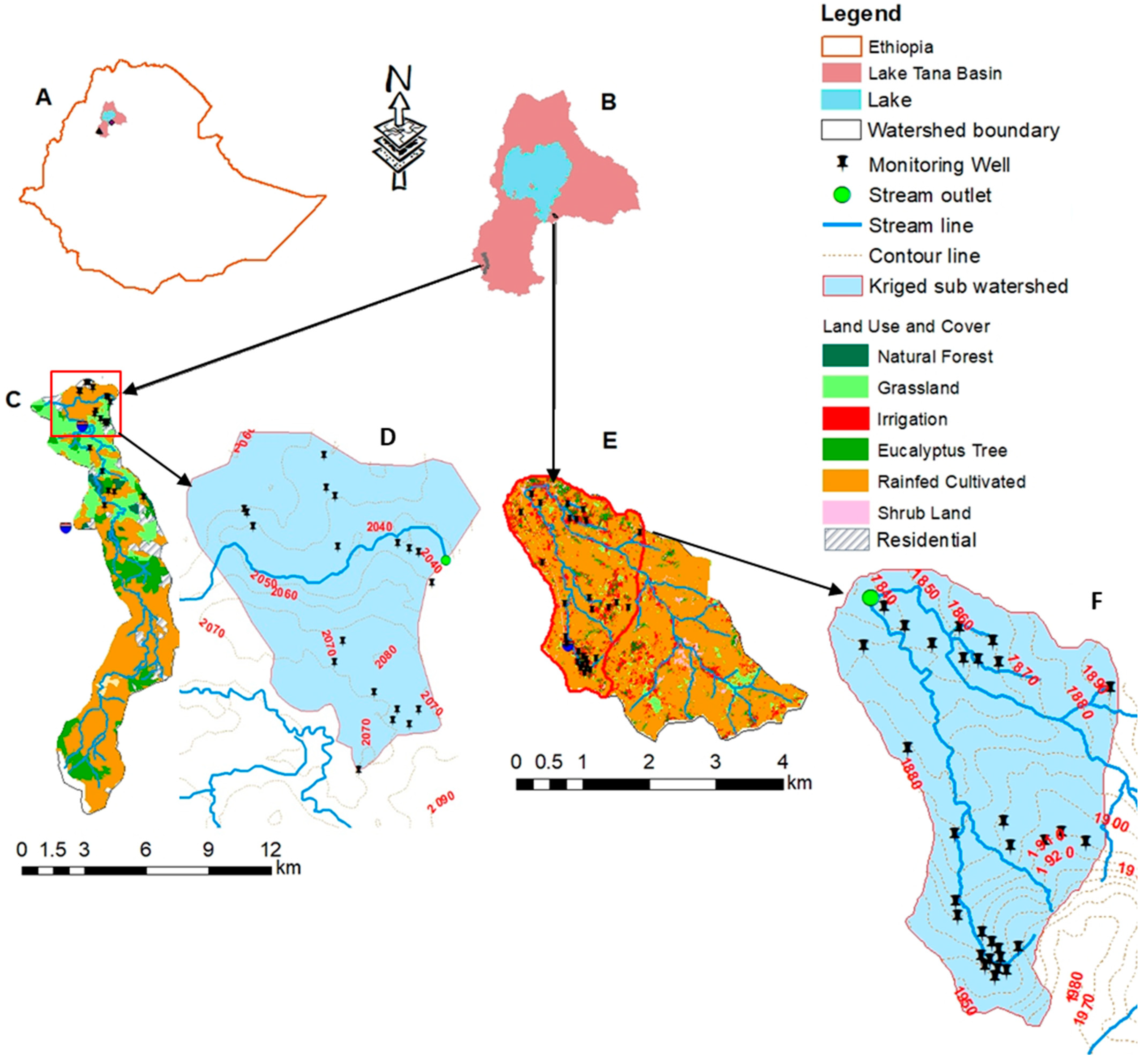
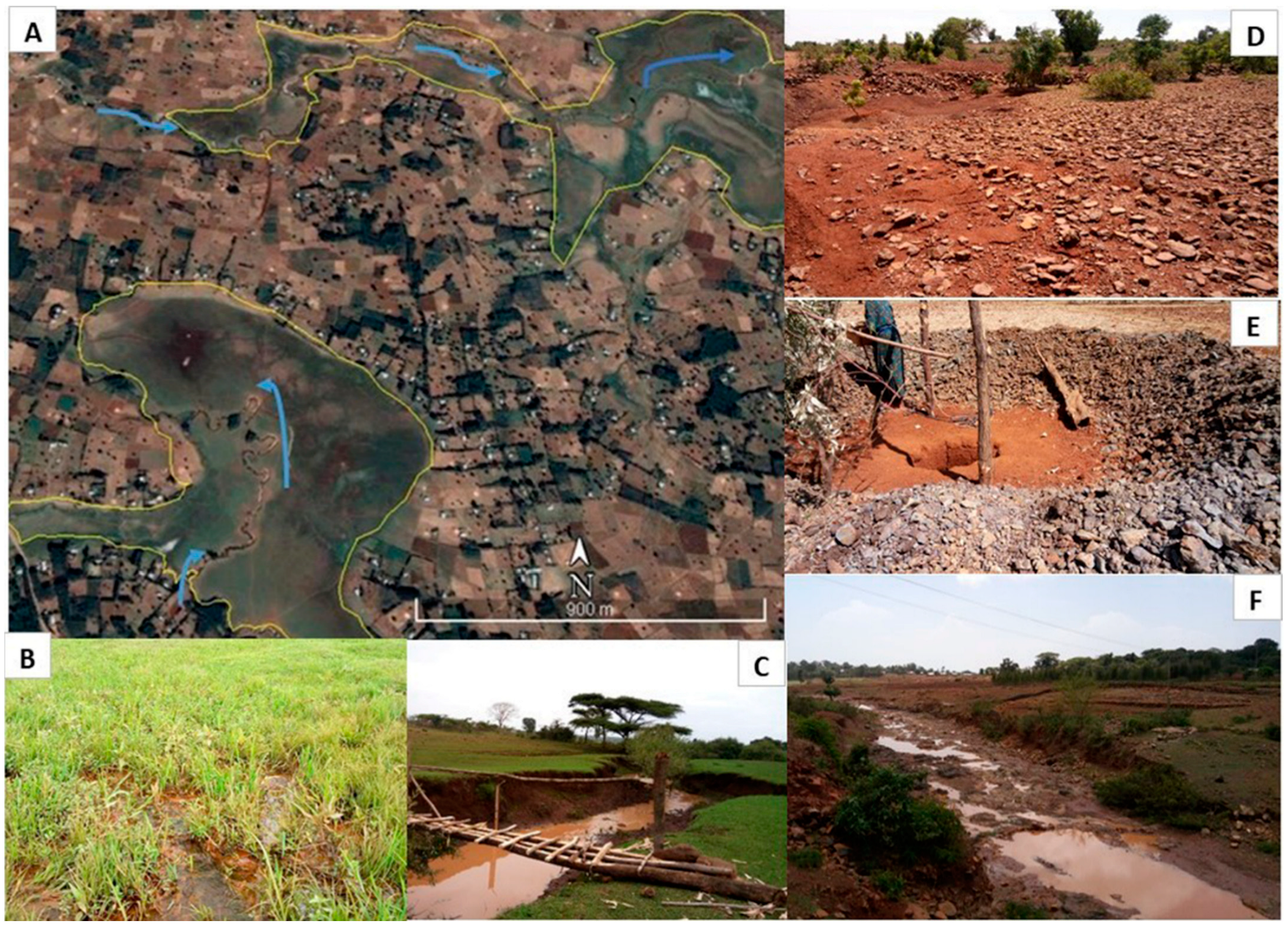
2.1. Description of the Two Watersheds
2.2. Data Collection
2.2.1. Precipitation
2.2.2. Data Collected at the Monitored Shallow Wells
2.2.3. Analysis of Chloride in Precipitation and Nitrate in Streams
2.2.4. Land-Use and Cover Data Acquisition
2.3. Data Analysis
2.3.1. Surface and Groundwater Interaction
2.3.2. Groundwater Redox Potential
2.3.3. Mapping of Groundwater Constituents
2.3.4. Statistical Data Analysis
3. Results
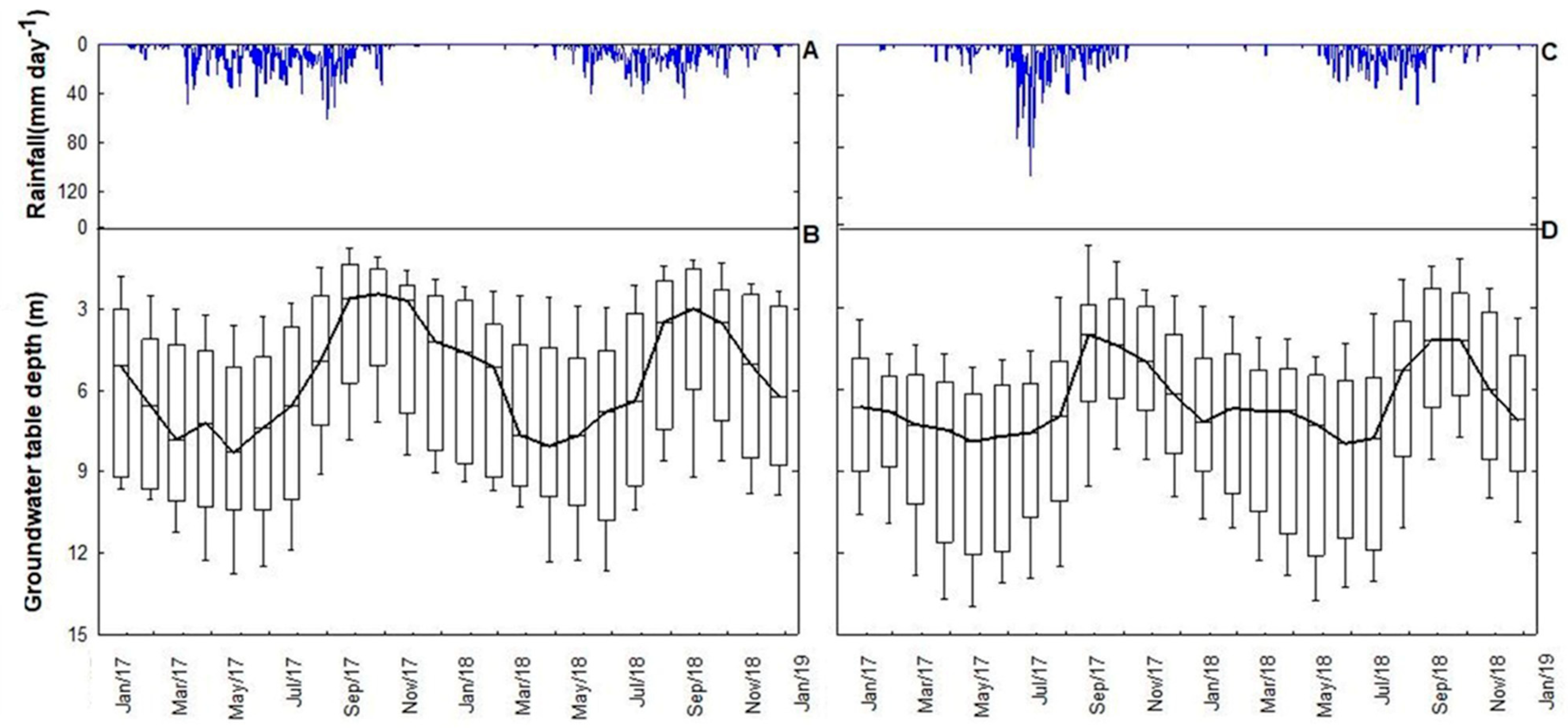
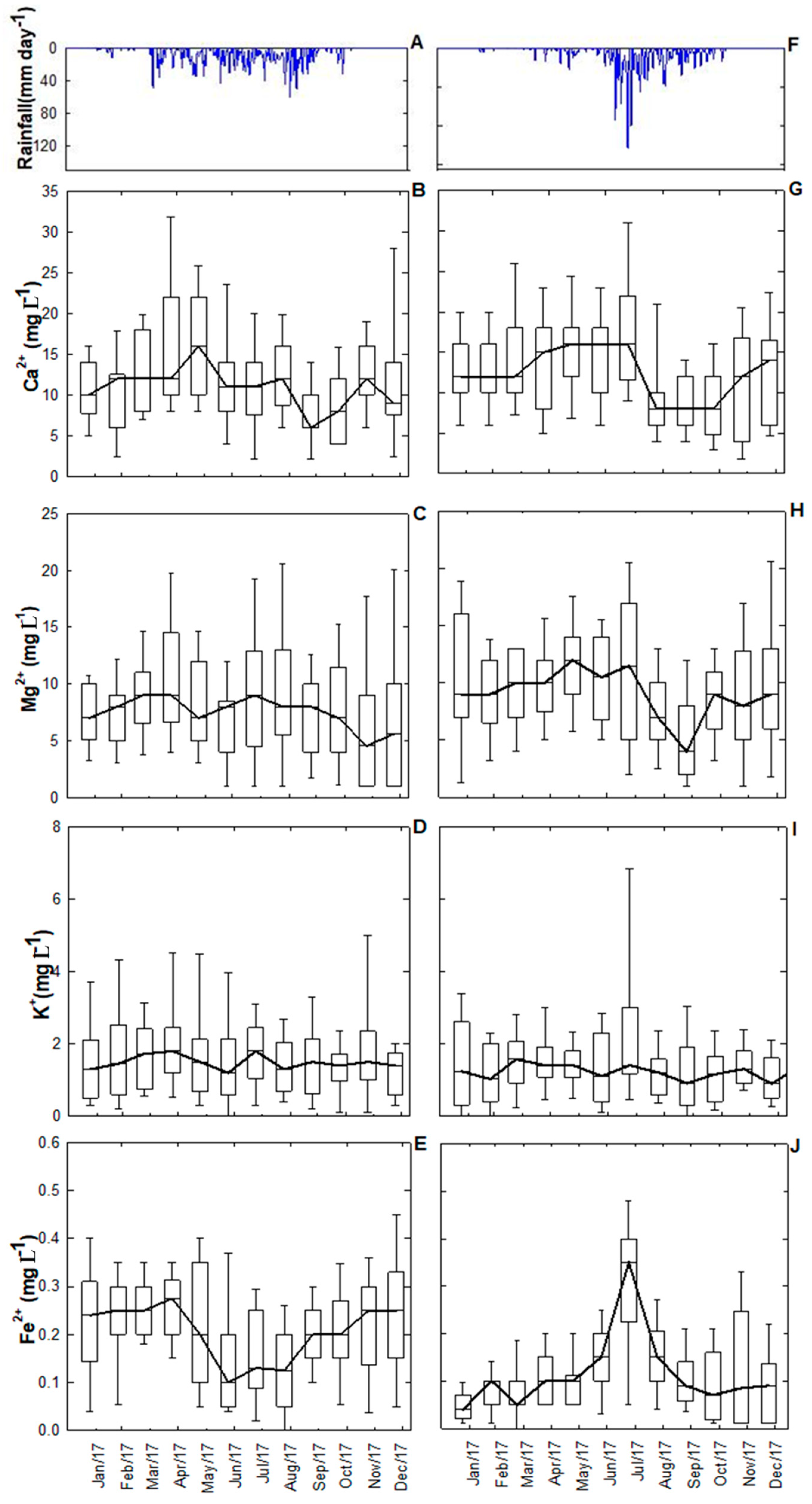
3.1. Precipitation
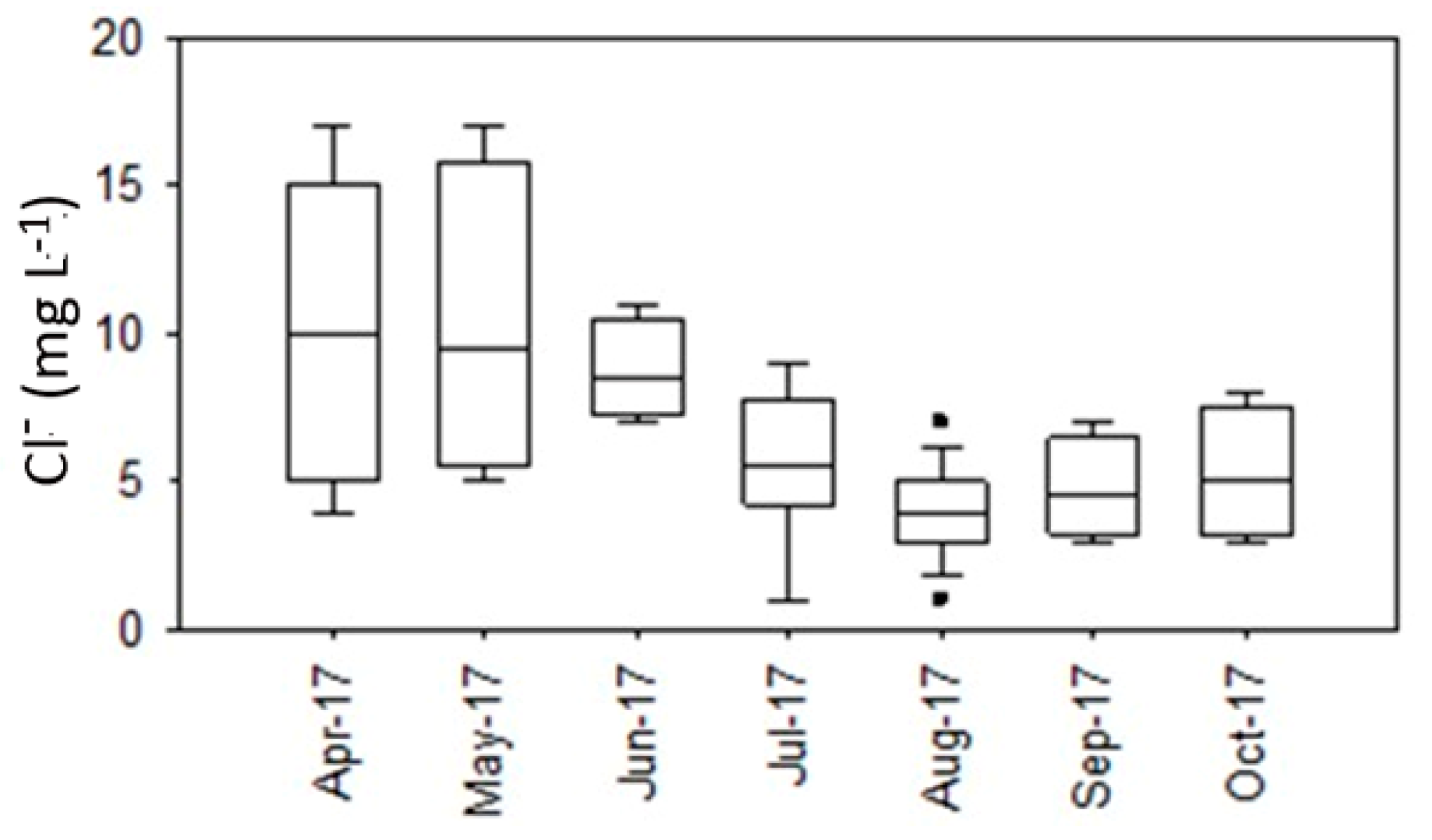
3.2. Chloride Concentration of the Precipitation
3.3. Groundwater
3.3.1. Temporal Variation in Groundwater Levels
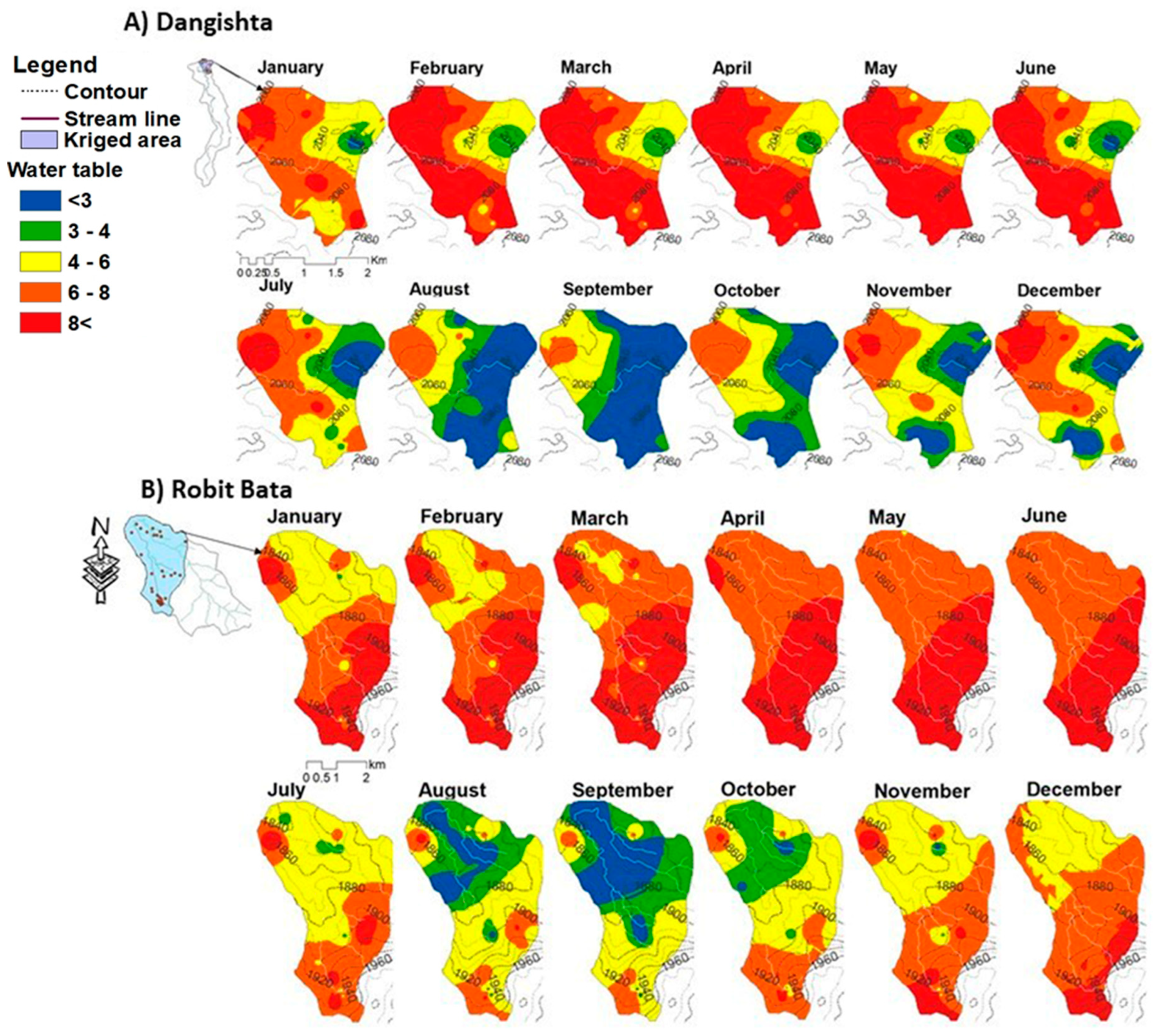
3.3.2. Spatial Occurrence of the Groundwater Table
3.4. Groundwater Constituents
3.4.1. pH
3.4.2. Calcium, Magnesium, and Potassium
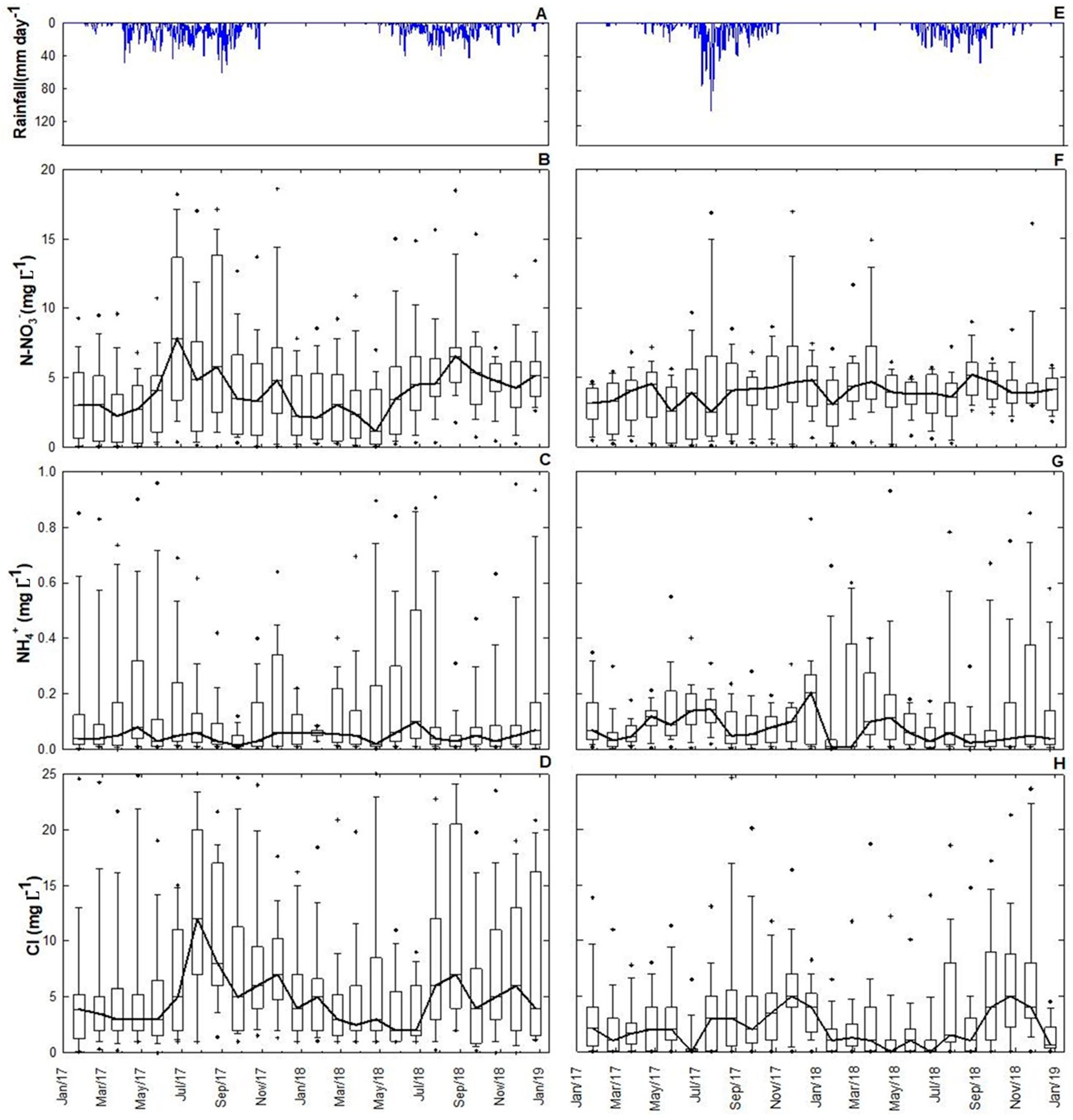
3.4.3. Chloride
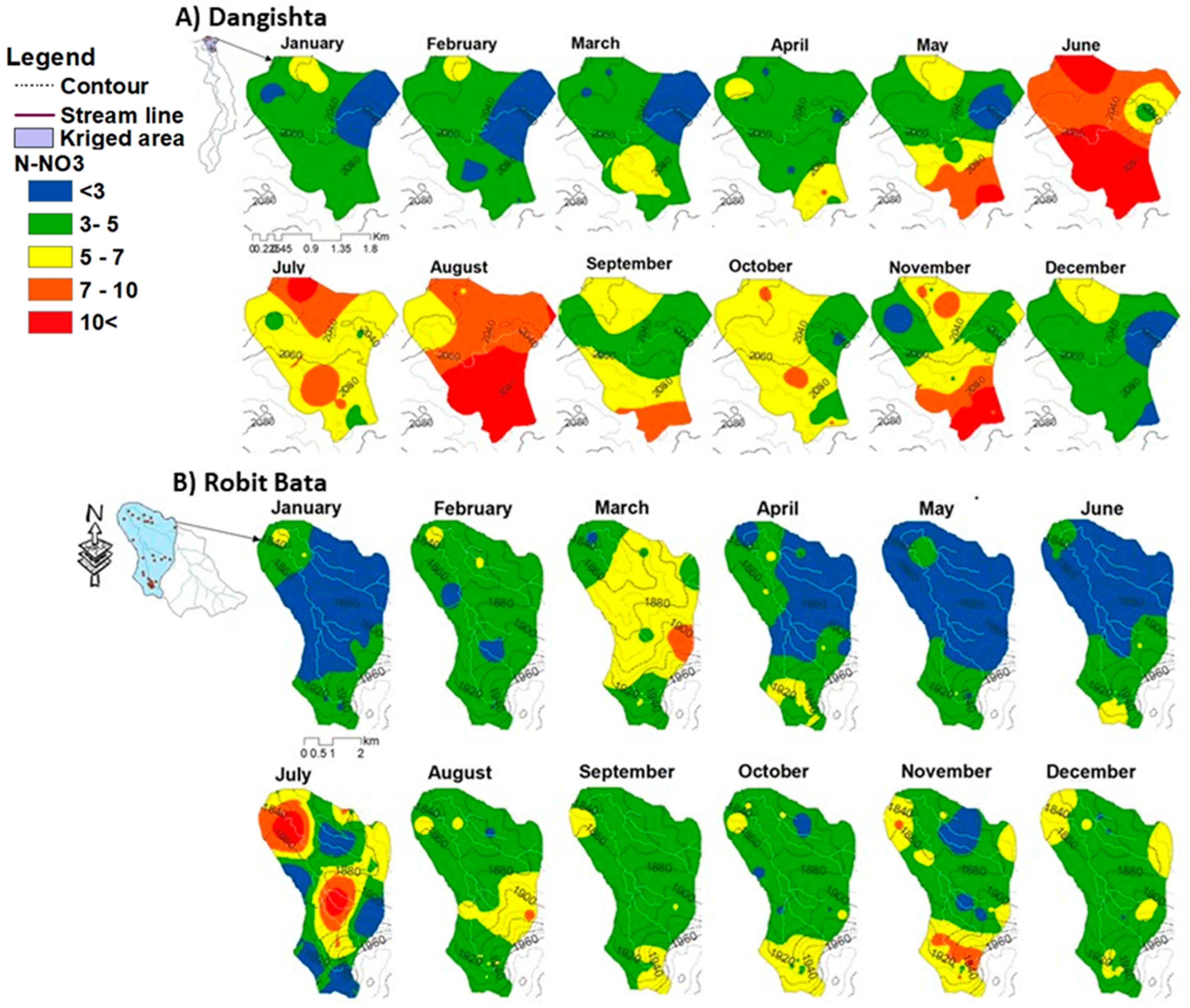
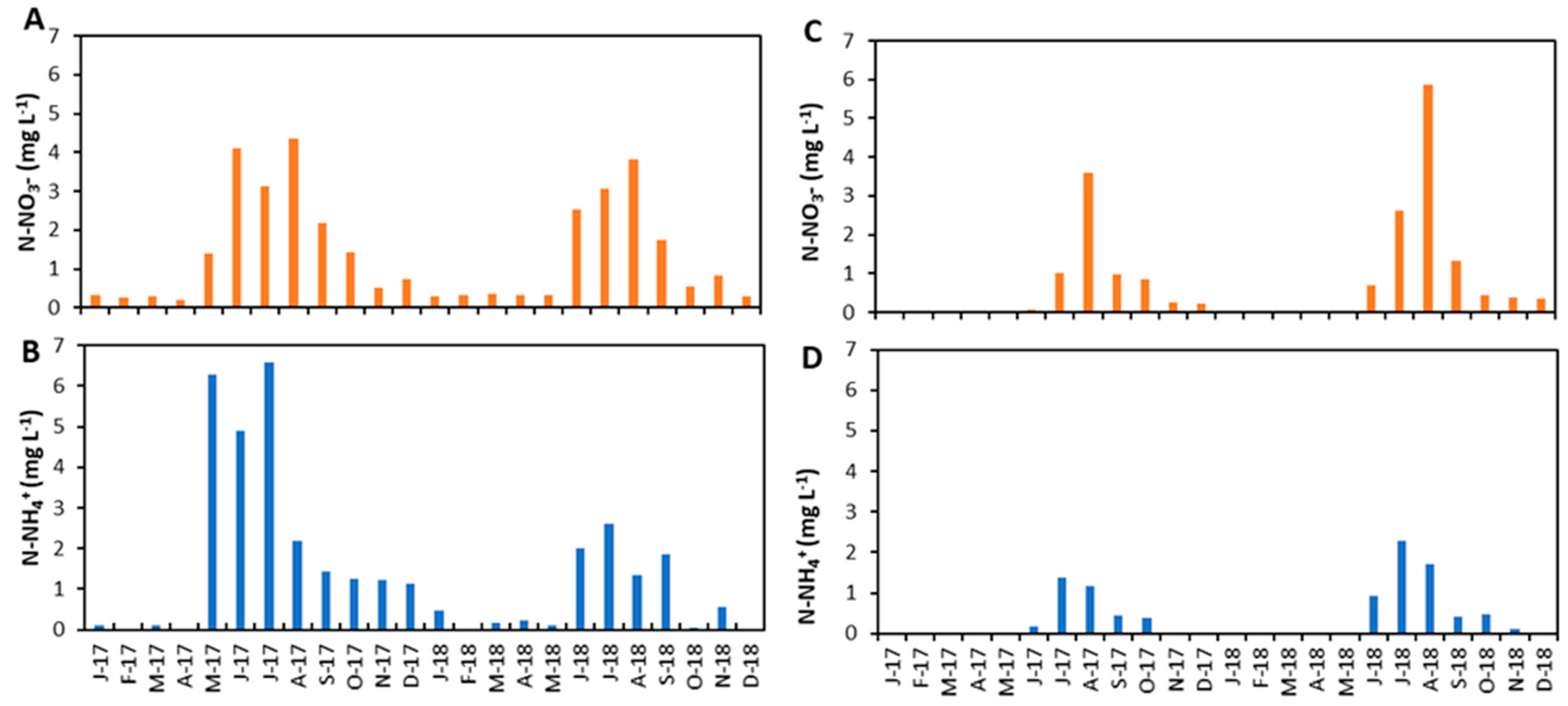
3.4.4. Nitrate
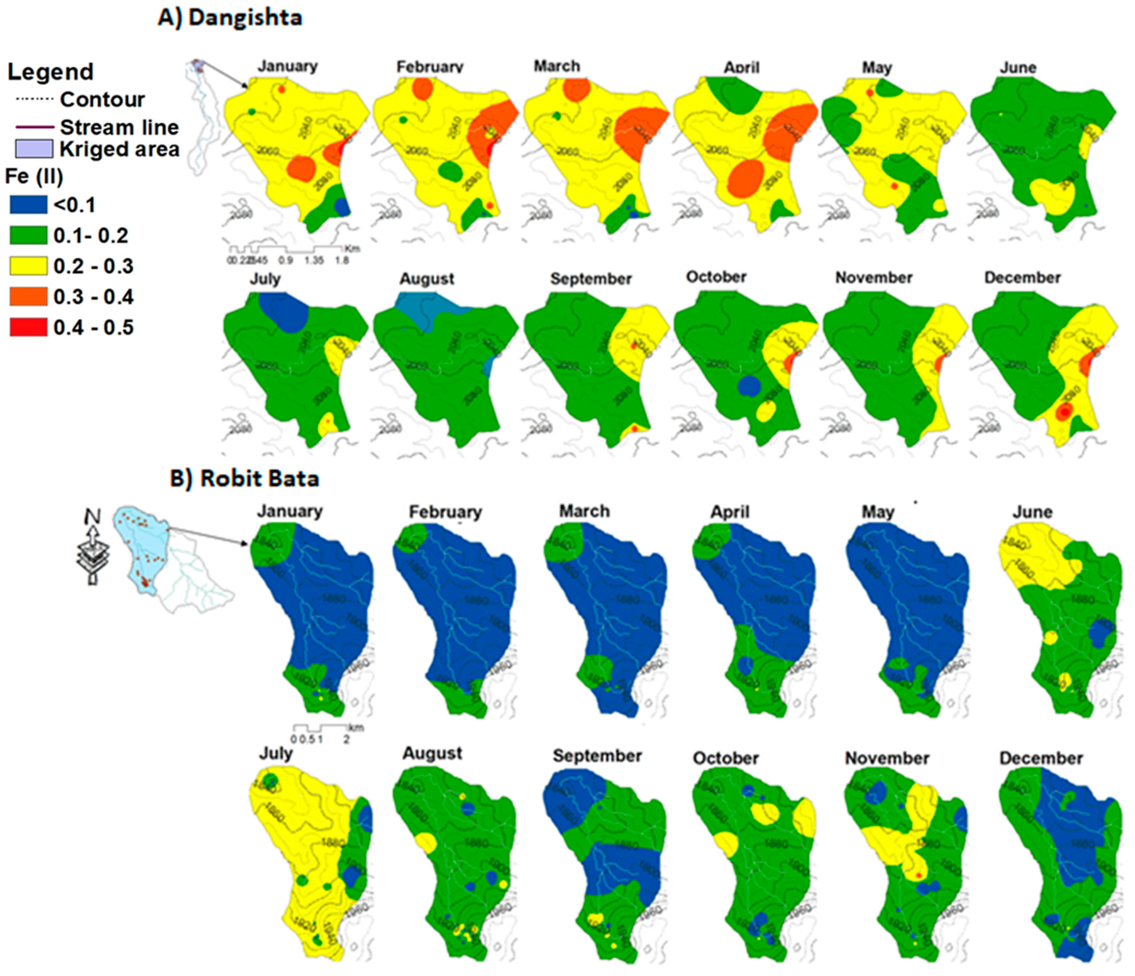
3.4.5. Reduced Iron and Ammonia (Fe2+ and NH4+) Concentration
3.5. Surface Runoff Nitrate and Ammonia Concentrations
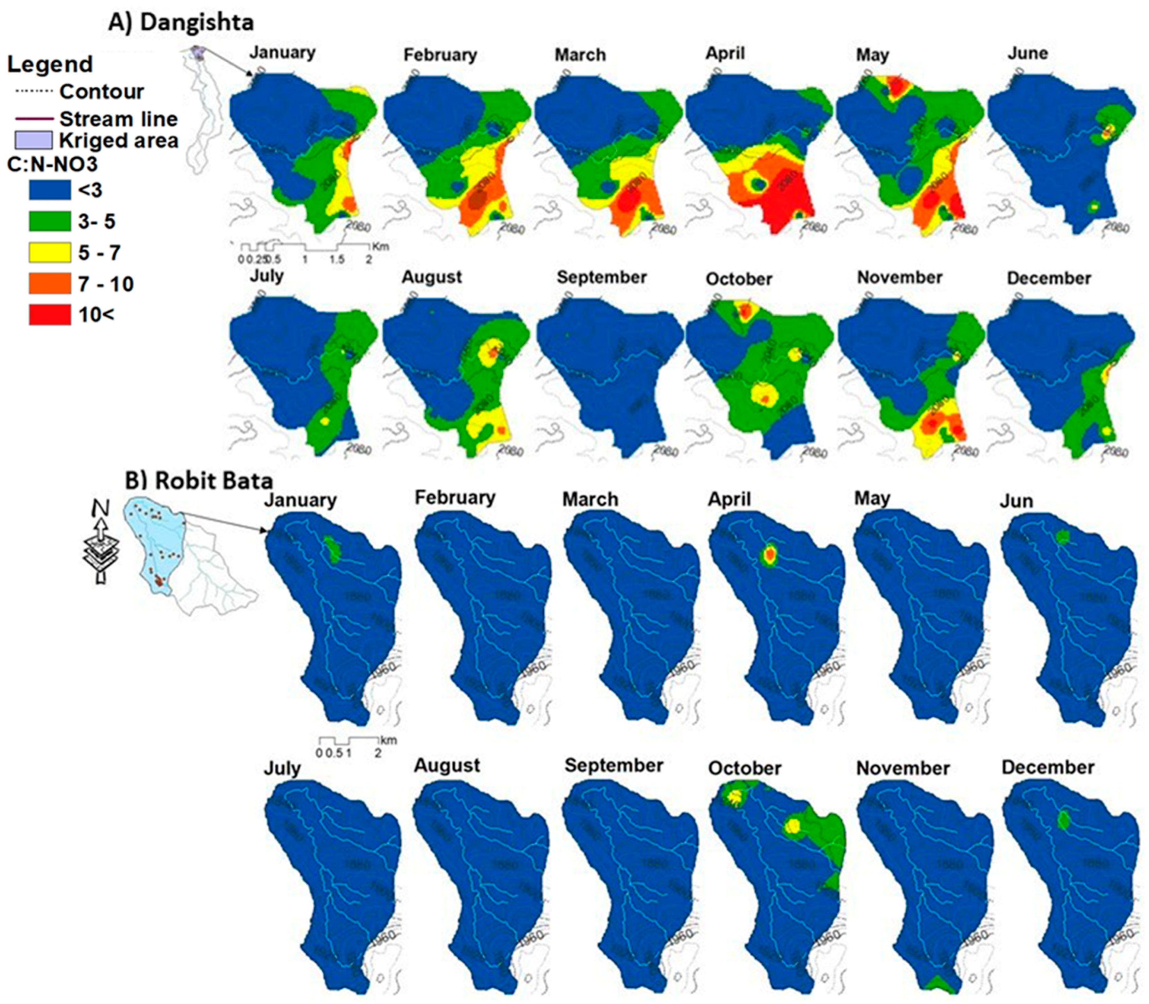
3.6. Relating Nitrate with Groundwater Constituents and Hydrology
3.6.1. Relationships between Nitrate, Hydrology, and Groundwater Constituents
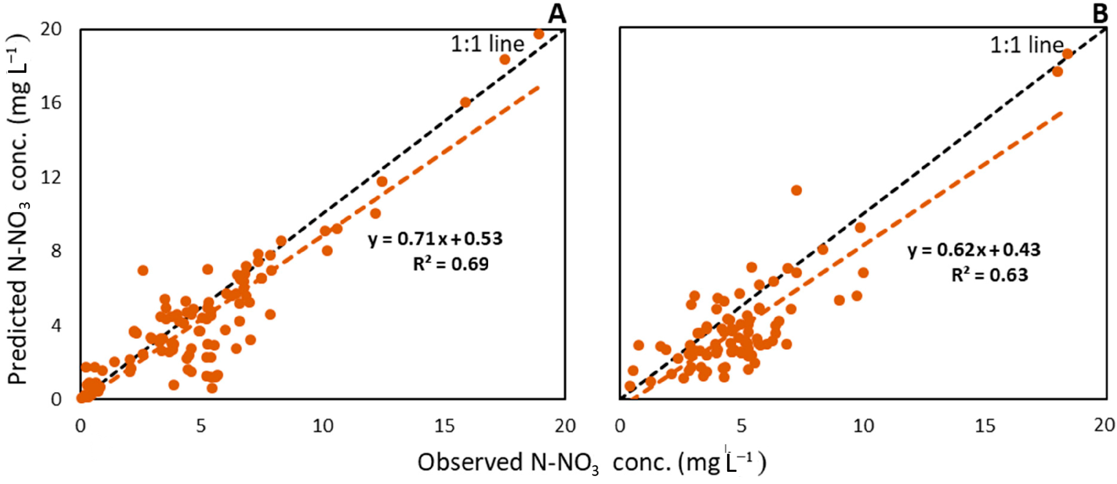
3.6.2. Multiple Linear Regression Model for Nitrate Concentrations
4. Discussion
4.1. Constituent Concentrations in Sloping Hillside Aquifers
4.2. Fate and Transport of Nitrate in Sloping Hillside Aquifers
5. Conclusions
Implications
Supplementary Materials
Author Contributions
Funding
Data Availability Statement
Conflicts of Interest
References
- Suthar, S. Contaminated drinking water and rural health perspectives in Rajasthan, India: An overview of recent case studies. Environ. Monit. Assess. 2011, 173, 837–849. [Google Scholar] [CrossRef] [PubMed]
- Shukla, S.; Saxena, A. Global Status of Nitrate Contamination in Groundwater: Its Occurrence, Health Impacts, and Mitigation Measures. In Handbook of Environmental Materials Management; Springer: Cham, Switzerland, 2019; pp. 869–888. [Google Scholar]
- Antiguedad, I.; Zabaleta, A.; Martinez-Santos, M.; Ruiz, E.; Uriarte, J.; Morales, T.; Comin, F.A.; Carranza, F.; Español, C.; Navarro, E.; et al. A simple multi-criteria approach to delimitate nitrate attenuation zones in alluvial floodplains. Four cases in south-western Europe. Ecol. Eng. 2017, 103, 315–331. [Google Scholar] [CrossRef]
- Gheysari, M.; Mirlatifi, S.M.; Homaee, M.; Asadi, M.E.; Hoogenboom, G. Nitrate leaching in a silage maize field under different irrigation and nitrogen fertilizer rates. Agric. Water Manag. 2009, 96, 946–954. [Google Scholar] [CrossRef]
- Jangam, C.; Pujari, P. Impact of on-site sanitation systems on groundwater sources in a coastal aquifer in Chennai, India. Environ. Sci. Pollut. Res. 2019, 26, 2079–2088. [Google Scholar] [CrossRef]
- Burow, K.R.; Shelton, J.L.; Dubrovsky, N.M. Occurrence of Nitrate and Pesticides in Ground water Beneath Three Agricultural Land-Use Settings in the Eastern San Joaquin Valley, California, 1993–1995; US Department of the Interior, US Geological Survey: Reston, VA, USA, 1998; Volume 97.
- Burow, K.R.; Nolan, B.T.; Rupert, M.G.; Dubrovsky, N.M. Nitrate in groundwater of the United States, 1991−2003. Environ. Sci. Technol. 2010, 44, 4988–4997. [Google Scholar] [CrossRef]
- Banks, E.W.; Cook, P.G.; Owor, M.; Okullo, J.; Kebede, S.; Nedaw, D.; Mleta, P.; Fallas, H.; Gooddy, D.; John MacAllister, D.; et al. Environmental tracers to evaluate groundwater residence times and water quality risk in shallow unconfined aquifers in sub Saharan Africa. J. Hydrol. 2021, 598, 125753. [Google Scholar] [CrossRef]
- MacAllister, D.J.; MacDonald, A.M.; Kebede, S.; Godfrey, S.; Calow, R. Comparative performance of rural water supplies during drought. Nat. Commun. 2020, 11, 1099. [Google Scholar] [CrossRef] [Green Version]
- Plumpton, H.; Cornforth, R. Groundwater Country Profiles for Seven UpGro Consortium Project Countries in Africa. Available online: https://upgro.org/country-profiles/ethiopia/ (accessed on 23 October 2022).
- Pavelic, P.; Giordano, M.; Keraita, B.N.; Ramesh, V.; Rao, T. Groundwater Availability and Use in Sub-Saharan Africa: A review of 15 Countries; International Water Management Institute: Colombo, Sri Lanka, 2012; p. 224. [Google Scholar]
- Fan, A.M.; Steinberg, V.E. Health Implications of Nitrate and Nitrite in Drinking Water: An Update on Methemoglobinemia Occurrence and Reproductive and Developmental Toxicity. Regul. Toxicol. Pharm. 1996, 23, 35–43. [Google Scholar] [CrossRef]
- WHO. Guidelines for Drinking-Water Quality, 3rd ed.; World Health Organization: Geneva, Switzerland, 2004; Volume 1, p. 494. [Google Scholar]
- Fenta, M.C.; Anteneh, Z.L.; Szanyi, J.; Walker, D. Hydrogeological framework of the volcanic aquifers and groundwater quality in Dangila Town and the surrounding area, Northwest Ethiopia. Groundw. Sustain. Dev. 2020, 11, 100408. [Google Scholar] [CrossRef]
- Berhanu, K.G.; Tegegn, A.M.; Aragaw, T.T.; Angualie, G.S.; Yismaw, A.B. The Secret of the Main Campus Water-Wells, Arba Minch University, Ethiopia. J. Environ. Public Health 2021, 2021, 4248505. [Google Scholar] [CrossRef]
- Asfaw, D.; Mengistu, D. Modeling megech watershed aquifer vulnerability to pollution using modified DRASTIC model for sustainable groundwater management, Northwestern Ethiopia. Groundw. Sustain. Dev. 2020, 11, 100375. [Google Scholar] [CrossRef]
- Tefera, A.K.; Wassie, A.B.; Sinshaw, B.G.; Defersha, D.T.; Takele, T.A.; Atanaw, S.B.; Tesfaye, A.T.; Getu, E.; Fenta, H.M.; Atinkut, H.B.; et al. Groundwater quality evaluation of the alluvial aquifers using GIS and water quality indices in the Upper Blue Nile Basin, Ethiopia. Groundw. Sustain. Dev. 2021, 14, 100636. [Google Scholar] [CrossRef]
- Schepp, C.; Diekkrüger, B.; Becker, M. Hillslope Hydrology in a Deeply Weathered Saprolite and Associated Nitrate Transport to a Valley Bottom Wetland in Central Uganda. Hydrology 2022, 9, 229. [Google Scholar] [CrossRef]
- Yimam, A.Y.; Bekele, A.M.; Nakawuka, P.; Schmitter, P.; Tilahun, S.A. Rainfall-Runoff Process and Groundwater Recharge in the Upper Blue Nile Basin: The Case of Dangishta Watershed. In Proceedings of the International Conference on Advances of Science and Technology, Bahir Dar, Ethiopia, 5–7 October 2018; pp. 536–549. [Google Scholar]
- Tilahun, S.A.; Yilak, D.L.; Schmitter, P.; Zimale, F.A.; Langan, S.; Barron, J.; Parlange, J.Y.; Steenhuis, T.S. Establishing irrigation potential of a hillside aquifer in the African highlands. Hydrol. Process. 2020, 34, 1741–1753. [Google Scholar] [CrossRef] [Green Version]
- Adem, A.A.; Addis, G.G.; Aynalem, D.W.; Tilahun, S.A.; Mekuria, W.; Azeze, M.; Steenhuis, T.S.J.W. Hydrogeology of Volcanic Highlands Affects Prioritization of Land Management Practices. Water 2020, 12, 2702. [Google Scholar] [CrossRef]
- Azagegn, T.; Asrat, A.; Ayenew, T.; Kebede, S. Litho-structural control on interbasin groundwater transfer in central Ethiopia. J. Afr. Earth Sci. 2015, 101, 383–395. [Google Scholar] [CrossRef]
- Dagnew, D.C.; Guzman, C.D.; Akale, A.T.; Tebebu, T.Y.; Zegeye, A.D.; Mekuria, W.; Tilahun, S.A.; Steenhuis, T.S. Effects of land use on catchment runoff and soil loss in the sub-humid Ethiopian highlands. Ecohydrol. Hydrobiol. 2017, 17, 274–282. [Google Scholar] [CrossRef]
- Droppelmann, K.J.; Snapp, S.S.; Waddington, S.R. Sustainable intensification options for smallholder maize-based farming systems in sub-Saharan Africa. Food Secur. 2017, 9, 133–150. [Google Scholar] [CrossRef]
- CSA. Farm Management Practices; The Federal Democratic Republic of Ethiopia Central Statistical Agency (CSA): Addis Ababa, Ethiopia, 2021.
- Nigate, F.; Van Camp, M.; Kebede, S.; Walraevens, K. Hydrologic interconnection between the volcanic aquifer and springs, Lake Tana basin on the Upper Blue Nile. J. Afr. Earth Sci. 2016, 121, 154–167. [Google Scholar] [CrossRef]
- BCEOM. Abay River Basin Integrated Master Plan, Main Report; Ministry of Water Resource (MOWR): Addis Ababa, Ethiopia, 1999.
- Abidela, M.H.; Muche, H.; Schmitter, P.; Nakawuka, P.; Tilahun, S.A.; Langan, S.; Barron, J.; Steenhuis, T.S. Deep Tillage Improves Degraded Soils in the (Sub) Humid Ethiopian Highlands. Land 2019, 8, 159. [Google Scholar] [CrossRef] [Green Version]
- Sishu, F.K.; Bekele, A.M.; Schmitter, P.; Tilahun, S.A.; Steenhuis, T.S. Phosphorus Export From Two Contrasting Rural Watersheds in the (Sub) Humid Ethiopian Highlands. Front. Earth Sci. 2021, 9, 1212. [Google Scholar] [CrossRef]
- Yimam, A.Y.; Assefa, T.T.; Sishu, F.K.; Tilahun, S.A.; Reyes, M.R.; Prasad, P.V.V. Estimating Surface and Groundwater Irrigation Potential under Different Conservation Agricultural Practices and Irrigation Systems in the Ethiopian Highlands. Water 2021, 13, 1645. [Google Scholar] [CrossRef]
- Getahun, A. Agricultural systems in Ethiopia. Agric. Syst. 1978, 3, 281–293. [Google Scholar] [CrossRef]
- Amejo, A.G.; Gebere, Y.M.; Kassa, H.; Tana, T. Characterization of smallholder mixed crop–livestock systems in integration with spatial information: In case Ethiopia. Cogent Food Agric. 2019, 5, 1565299. [Google Scholar] [CrossRef]
- Sishu, F.K.; Thegaye, E.K.; Schmitter, P.; Habtu, N.G.; Tilahun, S.A.; Steenhuis, T.S. Endosulfan Pesticide Dissipation and Residue Levels in Khat and Onion in a Sub-Humid Region of Ethiopia. In Proceedings of the International Conference on Advances of Science and Technology, Bahir Dar, Ethiopia, 2–4 August 2019; pp. 16–28. [Google Scholar]
- Brown, E.; Skougstad, M.W.; Fishman, M. Methods for Collection and Analysis of Water Samples for Dissolved Minerals and Gases; U.S. Government Printing Office: Washington, DC, USA, 1970.
- Baird, R.B.; Eaton, A.D.; Rice, E.W.; Bridgewater, L. Standard Methods for the Examination of Water and Wastewater, 23rd ed.; American Public Health Association, American Water Works Association, Water Environment Federation: Washington, DC, USA, 2017; Volume 23. [Google Scholar]
- Palin, A.T. Palintest Water Analysis Technology. Available online: https://www.palintest.com/parameters/ (accessed on 27 November 2021).
- ADSEW. Land Use Development and Management Planning. Available online: http://www.adswe.com.et/ (accessed on 19 March 2023).
- McLay, C.D.A.; Dragten, R.; Sparling, G.; Selvarajah, N. Predicting groundwater nitrate concentrations in a region of mixed agricultural land use: A comparison of three approaches. Environ. Pollut. 2001, 115, 191–204. [Google Scholar] [CrossRef]
- Koh, D.-C.; Kim, E.-Y.; Ryu, J.-S.; Ko, K.-S. Factors controlling groundwater chemistry in an agricultural area with complex topographic and land use patterns in mid-western South Korea. Hydrol. Process. 2009, 23, 2915–2928. [Google Scholar] [CrossRef]
- Ki, M.-G.; Koh, D.-C.; Yoon, H.; Kim, H.-S. Temporal variability of nitrate concentration in groundwater affected by intensive agricultural activities in a rural area of Hongseong, South Korea. Environ. Earth Sci. 2015, 74, 6147–6161. [Google Scholar] [CrossRef]
- McMahon, P.; Cowdery, T.; Chapelle, F.; Jurgens, B. Redox Conditions in Selected Principal Aquifers of the United States; 2327–6932; US Geological Survey: Reston, VA, USA, 2009.
- Krige, D.G. A statistical approach to some basic mine valuation problems on the Witwatersrand. J. South. Afr. Inst. Min. Metall. 1951, 52, 119–139. [Google Scholar]
- Matheron, G. Principles of geostatistics. Econ. Geol. 1963, 58, 1246–1266. [Google Scholar] [CrossRef]
- Goovaerts, P. Geostatistics in soil science: State-of-the-art and perspectives. Geoderma 1999, 89, 1–45. [Google Scholar] [CrossRef]
- Alemie, T.C.; Tilahun, S.A.; Ochoa-Tocachi, B.F.; Schmitter, P.; Buytaert, W.; Parlange, J.Y.; Steenhuis, T.S. Predicting shallow groundwater tables for sloping highland aquifers. Water Resour. Res. 2019, 55, 11088–11100. [Google Scholar] [CrossRef]
- Woldemariyam, F.; Ayenew, T. Identification of hydrogeochemical processes in groundwater of Dawa River basin, southern Ethiopia. Environ. Monit. Assess. 2016, 188, 481. [Google Scholar] [CrossRef]
- Enku, T.; Melesse, A.M.; Ayana, E.K.; Tilahun, S.A.; Abate, M.; Steenhuis, T.S. Groundwater Evaporation and Recharge for a Floodplain in a Sub-humid Monsoon Climate in Ethiopia. Land Degrad. Dev. 2017, 28, 1831–1841. [Google Scholar] [CrossRef]
- Walker, D.; Parkin, G.; Gowing, J.; Haile, A.T. Development of a Hydrogeological Conceptual Model for Shallow Aquifers in the Data Scarce Upper Blue Nile Basin. Hydrology 2019, 6, 43. [Google Scholar] [CrossRef] [Green Version]
- Katou, H. Determining competitive nitrate and chloride adsorption in an andisol by the unsaturated transient flow method. Soil Sci. Plant Nutr. 2004, 50, 119–127. [Google Scholar] [CrossRef]
- Akale, A.T.; Moges, M.A.; Dagnew, D.C.; Tilahun, S.A.; Steenhuis, T.S. Assessment of Nitrate in Wells and Springs in the North Central Ethiopian Highlands. Water 2018, 10, 476. [Google Scholar] [CrossRef] [Green Version]
- Lentz, R.D.; Lehrsch, G.A. Temporal changes in δ18O and δ15N of nitrate nitrogen and H2O in shallow groundwater: Transit time and nitrate-source implications for an irrigated tract in southern Idaho. Agric. Water Manag. 2019, 212, 126–135. [Google Scholar] [CrossRef]
- Castro-Barros, C.M.; Jia, M.; van Loosdrecht, M.C.M.; Volcke, E.I.P.; Winkler, M.K.H. Evaluating the potential for dissimilatory nitrate reduction by anammox bacteria for municipal wastewater treatment. Bioresour. Technol. 2017, 233, 363–372. [Google Scholar] [CrossRef]
- Setargie, T.A.; Tilahun, S.A.; Schmitter, P.; Moges, M.A.; Gurmessa, S.K.; Tsunekawa, A.; Tsubo, M.; Berihun, M.L.; Fenta, A.A.; Haregeweyn, N. Characterizing shallow groundwater in hillslope aquifers using isotopic signatures: A case study in the Upper Blue Nile basin, Ethiopia. J. Hydrol. Reg. Stud. 2021, 37, 100901. [Google Scholar] [CrossRef]
- Abebe, T.G.; Tamtam, M.R.; Abebe, A.A.; Abtemariam, K.A.; Shigut, T.G.; Dejen, Y.A.; Haile, E.G. Growing Use and Impacts of Chemical Fertilizers and Assessing Alternative Organic Fertilizer Sources in Ethiopia. Appl. Environ. Soil Sci. 2022, 2022, 4738416. [Google Scholar] [CrossRef]
- Brhane, G.K. Characterization of hydro chemistry and groundwater quality evaluation for drinking purpose in Adigrat area, Tigray, northern Ethiopia. Water Sci. 2018, 32, 213–229. [Google Scholar] [CrossRef] [Green Version]


| Fertilizers | Ingredients | Application Rate (kg N or P ha−1) | National-Level Application (CSA 2021) | ||||||
|---|---|---|---|---|---|---|---|---|---|
| Dangishta | Robit Bata | ||||||||
| Rainfed | Rainfed | Irrigation | |||||||
| N | P | N | P | N | P | N | P | ||
| UREA CO(NH2)2 | N.P.K (46:0:0) | 48 | 0 | 45 | 0 | 5 | 0 | ||
| DAP (NH4)2HPO4 | 18% N, and 20% P | 24 | 27 | 23 | 25 | 2 | 3 | ||
| Compost | 1.8% N, 0.25% P | 3 | 0.4 | 1 | 0.1 | 22 | 3 | ||
| Total | Total applied (kg ha−1) | 75 | 27 | 69 | 25 | 29 | 6 | 43 | 17 |
| Watershed | Statistic | pH | EC | N-NO3− | N-NH4+ | Cl− | K+ | Mg2+ | Ca2+ | Fe2+ |
|---|---|---|---|---|---|---|---|---|---|---|
| Dangishta | Min. | 5.1 | 44 | 0.1 | <0.01 | <0.01 | <0.01 | 2 | 1 | <0.01 |
| Max. | 7.1 | 296 | 20.2 | 4.4 | 82 | 31 | 41 | 44 | 0.7 | |
| mean | 5.8 | 152 | 4.6 | 0.1 | 6.9 | 1.8 | 9 | 12 | 0.2 | |
| Sd. | 0.4 | 56 | 3.9 | 0.3 | 9.1 | 2 | 8 | 12 | 0.1 | |
| Med. | 6.1 | 150 | 4.0 | 0.1 | 4 | 1.5 | 6 | 7 | 0.3 | |
| %Cv. | 6.7 | 37 | 84.4 | 289 | 132.1 | 90.4 | 71 | 56 | 83.3 | |
| Robit Bata | Min. | 5.6 | 43 | 0.1 | <0.01 | <0.01 | <0.01 | 4 | 1 | <0.01 |
| Max. | 7.5 | 646 | 19 | 2.4 | 38 | 10.5 | 42 | 48 | 0.8 | |
| Mean | 6.7 | 144 | 4.0 | 0.1 | 4.1 | 1.3 | 10 | 13 | 0.1 | |
| Sd. | 0.3 | 59 | 2.6 | 0.2 | 4.6 | 1 | 9 | 12 | 0.1 | |
| Med. | 6.5 | 138 | 4.1 | 0.1 | 3 | 1.2 | 5.5 | 6.8 | 0.11 | |
| %Cv. | 4.8 | 41 | 65.3 | 199 | 112 | 80.2 | 57.7 | 51.3 | 89.9 |
| (A) | P | GWTD | pH | EC | Mg2+ | Ca2+ | K+ | Fe2+ | N-NH4+ | Cl− | N-NO3− |
| P | 1 | ||||||||||
| GWTD | −0.191 ** | 1 | |||||||||
| pH | 0.044 | −0.105 | 1 | ||||||||
| Ec | −0.361 ** | 0.029 | 0.323 ** | 1 | |||||||
| Mg2+ | 0.038 | −0.040 | 0.007 | 0.320 ** | 1 | ||||||
| Ca2+ | 0.009 | −0.020 | 0.008 | 0.357 ** | 0.981 ** | 1 | |||||
| K+ | −0.002 | 0.156 ** | 0.313 ** | 0.235 ** | −0.007 | −0.015 | 1 | ||||
| Fe2+ | −0.256 ** | 0.106 | 0.064 | 0.030 | −0.064 | −0.064 | 0.162 ** | 1 | |||
| N-NH4+ | −0.04 | 0.095 | 0.088 | 0.098 | −0.081 | −0.088 | 0.420 ** | 0.136 | 1 | ||
| Cl− | 0.196 ** | −0.110 * | −0.162 * | −0.096 | 0.242 ** | 0.235 ** | 0.092 | −0.168 ** | −0.012 | 1 | |
| N-NO3− | 0.127 ** | 0.197 ** | −0.248 ** | −0.128 ** | 0.089 | 0.099 | −0.060 | −0.551 ** | −0.136 ** | 0.511 ** | 1 |
| (B) | P | GWTD | pH | EC | Mg2+ | Ca2+ | K+ | Fe2+ | N-NH4+ | Cl− | N-NO3− |
| P | 1 | ||||||||||
| GWTD | −0.216 ** | 1 | |||||||||
| pH | −0.156 * | −0.190 ** | 1 | ||||||||
| Ec | −0.295 ** | 0.259 ** | 0.010 | 1 | |||||||
| Mg2+ | −0.153 * | 0.077 | 0.232 ** | 0.265 ** | 1 | ||||||
| Ca2+ | −0.113 | 0.347 ** | 0.117 * | 0.412 ** | 0.286 ** | 1 | |||||
| K+ | 0.148 * | 0.222 ** | 0.165 ** | 0.131 * | 0.228 ** | 0.124 * | 1 | ||||
| Fe2+ | 0.236 ** | −0.077 | 0.174 ** | −0.037 | −0.015 | −0.015 | 0.022 | 1 | |||
| N-NH4+ | −0.005 | −0.018 | 0.138 * | 0.074 | 0.094 | 0.196 ** | 0.288 ** | 0.083 | 1 | ||
| Cl− | 0.129 * | −0.170 ** | 0.091 | −0.122 | 0.025 | −0.104 | −0.032 | −0.019 | 0.024 | 1 | |
| N-NO3− | 0.162 * | 0.144 * | −0.008 | −0.053 | 0.106 | −0.044 | 0.291 ** | −0.059 | −0.035 | 0.672 ** | 1 |
| Watersheds | Name | Coefficient (β) | t-Test | p | Adjusted R2 | Relative Importance |
|---|---|---|---|---|---|---|
| Dangishta | Intercept | 8.6 | 3.6 | 0.02 | 0.70 | |
| Cl− | 0.31 | 13 | <0.001 | 0.52 | ||
| Fe2+ | 12.6 | −6.7 | <0.001 | 0.39 | ||
| GWD | 0.25 | 5.5 | <0.001 | 0.08 | ||
| Robit Bata | Intercept | 0.55 | 1.3 | 0.09 | 0.63 | |
| Cl− | 0.62 | 15.1 | <0.001 | 0.84 | ||
| Fe2+ | −1.85 | −2.0 | 0.042 | 0.01 | ||
| GWD | 0.14 | 3.5 | <0.001 | 0.07 | ||
| P | 0.002 | 3.2 | 0.002 | 0.06 |
Disclaimer/Publisher’s Note: The statements, opinions and data contained in all publications are solely those of the individual author(s) and contributor(s) and not of MDPI and/or the editor(s). MDPI and/or the editor(s) disclaim responsibility for any injury to people or property resulting from any ideas, methods, instructions or products referred to in the content. |
© 2023 by the authors. Licensee MDPI, Basel, Switzerland. This article is an open access article distributed under the terms and conditions of the Creative Commons Attribution (CC BY) license (https://creativecommons.org/licenses/by/4.0/).
Share and Cite
Sishu, F.K.; Tilahun, S.A.; Schmitter, P.; Steenhuis, T.S. Investigating Nitrate with Other Constituents in Groundwater in Two Contrasting Tropical Highland Watersheds. Hydrology 2023, 10, 82. https://doi.org/10.3390/hydrology10040082
Sishu FK, Tilahun SA, Schmitter P, Steenhuis TS. Investigating Nitrate with Other Constituents in Groundwater in Two Contrasting Tropical Highland Watersheds. Hydrology. 2023; 10(4):82. https://doi.org/10.3390/hydrology10040082
Chicago/Turabian StyleSishu, Feleke K., Seifu A. Tilahun, Petra Schmitter, and Tammo S. Steenhuis. 2023. "Investigating Nitrate with Other Constituents in Groundwater in Two Contrasting Tropical Highland Watersheds" Hydrology 10, no. 4: 82. https://doi.org/10.3390/hydrology10040082