
The Imprint of Recent Meteorological Events on Boulder Deposits along the Mediterranean Rocky Coasts


Abstract
:1. Introduction
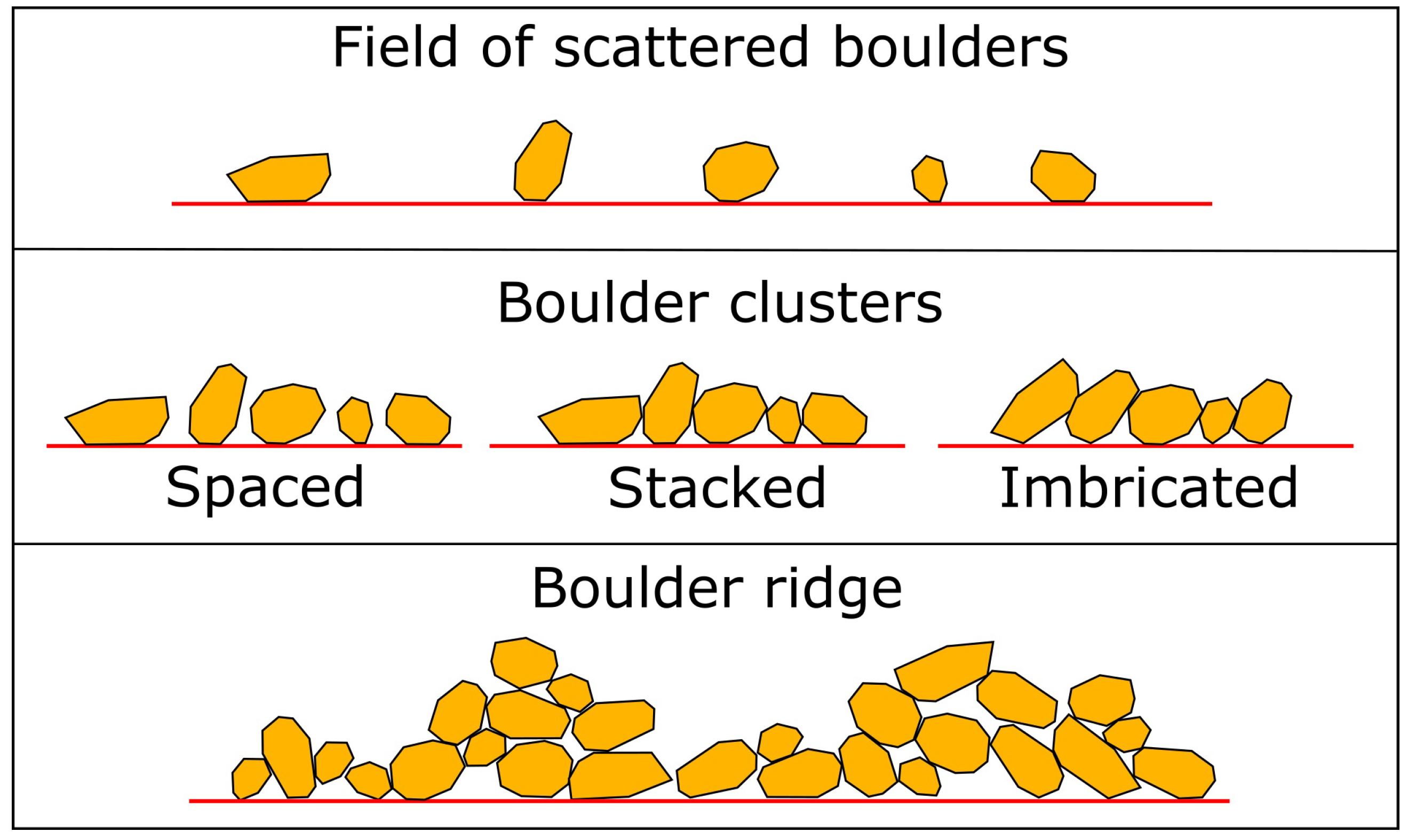
2. Basic Concepts
3. Materials and Methods
4. Review Results
5. Analysis of the Causative Events
5.1. Meteorological Events Description
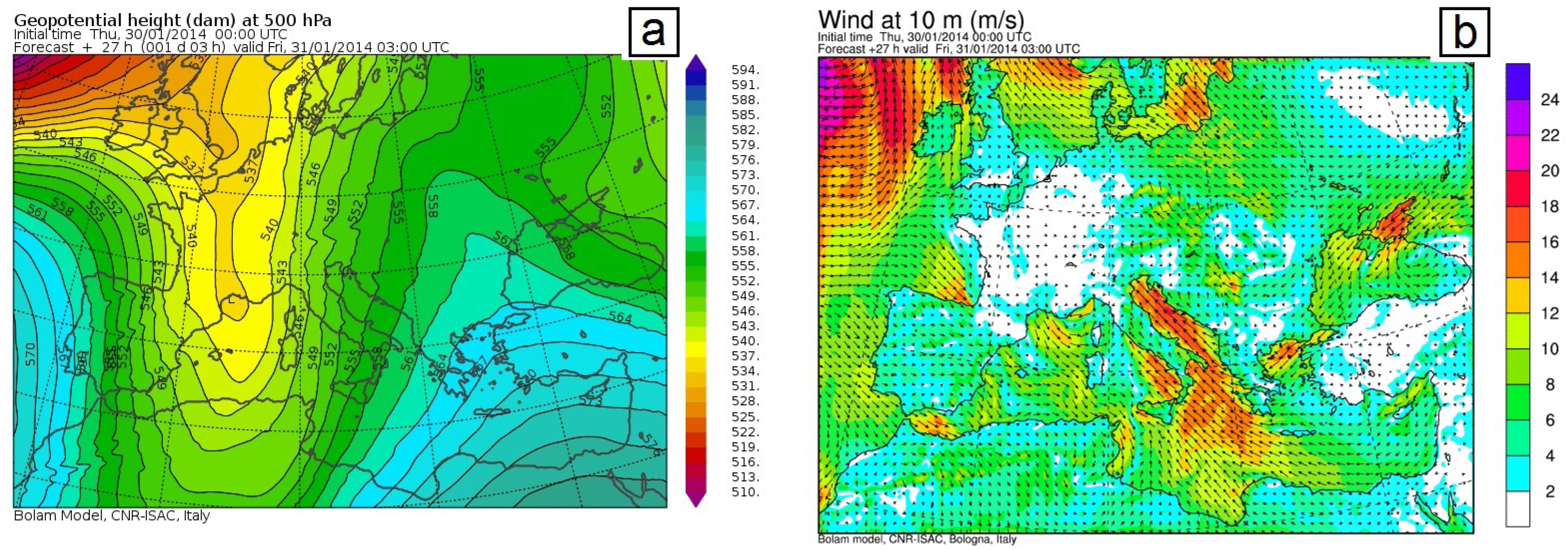
5.1.1. 31 January 2014
5.1.2. 7 November 2014 (Medicane Qendresa)
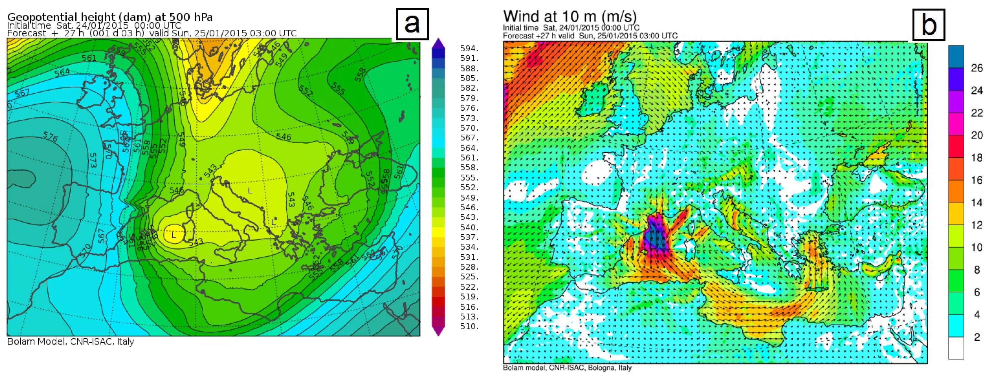
5.1.3. 25 January 2015
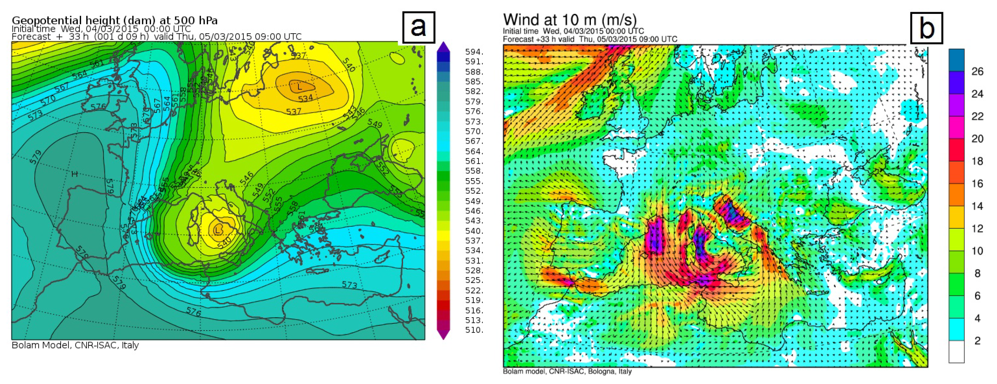
5.1.4. 5 March 2015
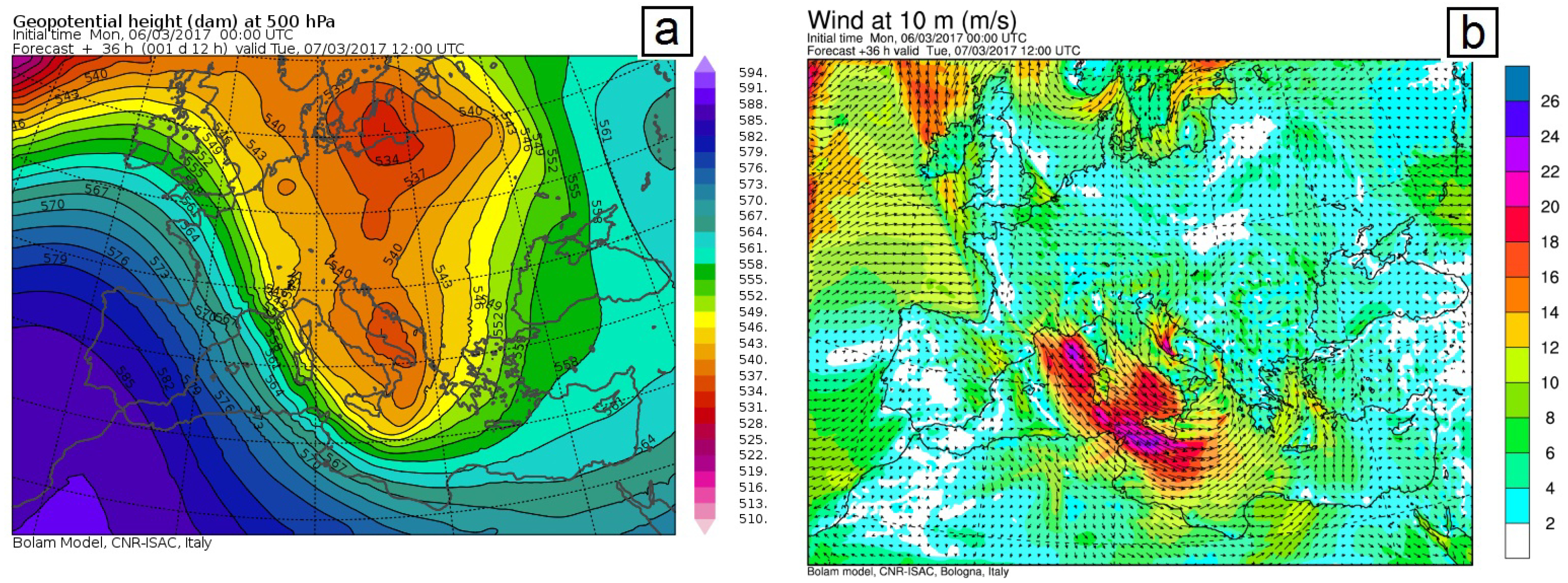
5.1.5. 7 March 2017
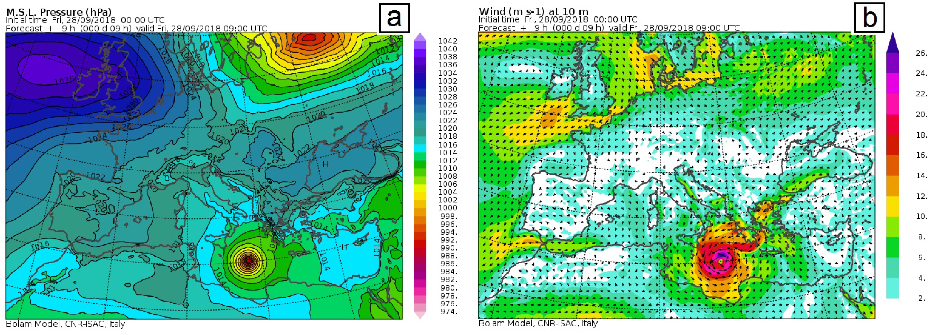
5.1.6. 28 September 2018 (Medicane Zorbas)
5.1.7. 29 October 2018 (Storm Vaia)
5.1.8. 13 November 2019 (Storm Detlef)
5.2. Inferred General Features
- Regional topography in wind-wave generation;
- Storm surges, sea level, and coastal morphology;
- Locations of boulder deposits.
5.2.1. Regional Topography in Wind-Wave Generation
5.2.2. Storm Surges, Sea Level, and Coastal Morphology
5.2.3. Locations of Boulder Deposits
6. Discussion
- The increase in the number of CBDs case studies;
- The suitability of rocky coasts as storm archives;
- The interdisciplinary research perspectives.
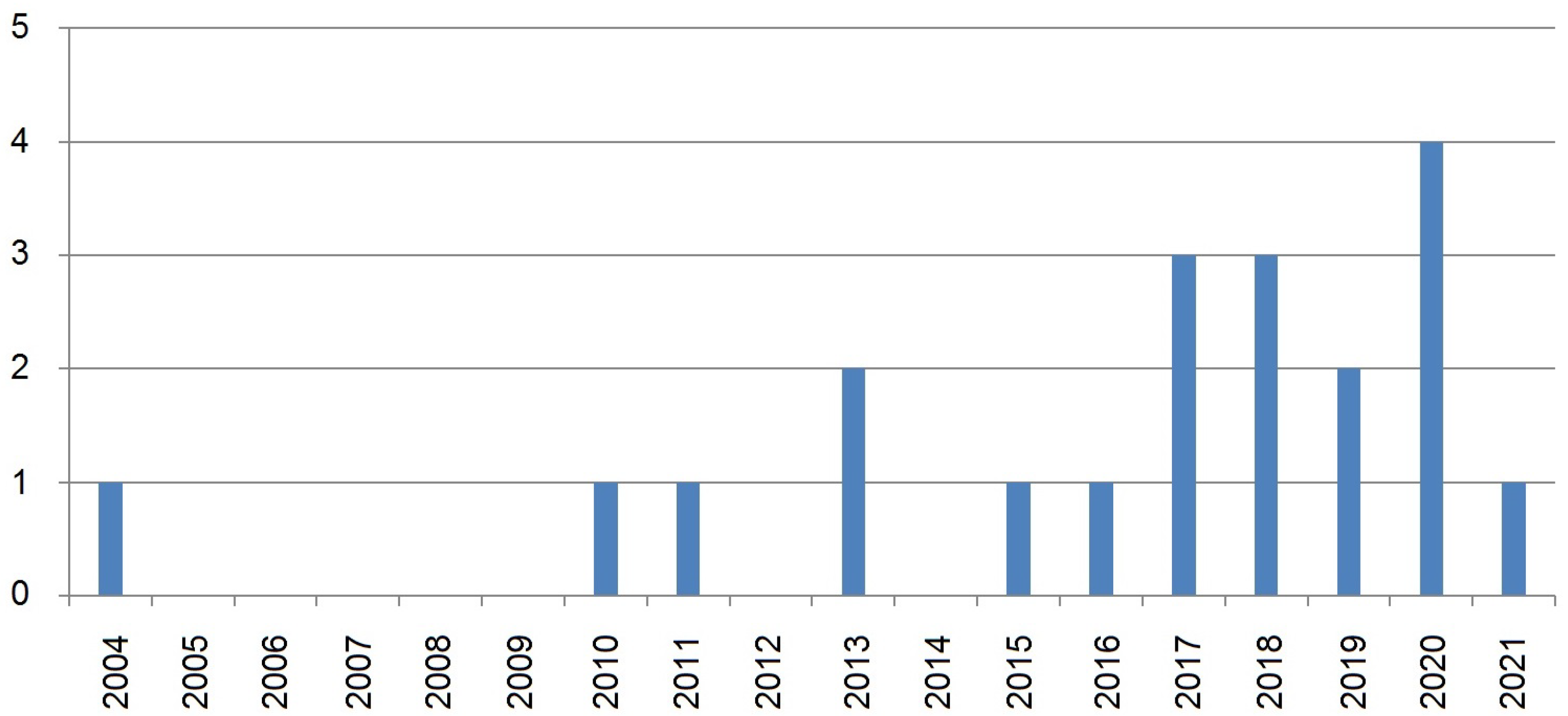
6.1. The Increase in the Number of CBDs Case Studies
6.2. The Suitability of Rocky Coasts as Storm Archives
6.3. The Interdisciplinary Research Perspectives
7. Conclusions
Author Contributions
Funding
Institutional Review Board Statement
Informed Consent Statement
Acknowledgments
Conflicts of Interest
Appendix A

| Author (s) and Year | Main Objective | Exclusion Cause |
|---|---|---|
| Dominey-Howes et al. (2000) [98] | process identification | CBDs produced by tsunami |
| Mastronuzzi et al. (2004) [99] | vulnerability study | No CBD dynamics data are reported |
| Andriani and Walsh (2007) [100] | process identification | No CBD dynamics data are reported |
| Scicchitano et al. (2010) [101] | process identification | No CBD dynamics data are reported |
| Furlani et al. (2011) [102] | process identification | No CBD dynamics data are reported |
| Paris et al. (2011) [2] | review preface | No CBD dynamics data are reported |
| Mastronuzzi and Pignatelli (2012) [103] | process identification | CBDs produced by tsunami |
| Katz and Mushkin (2013) [104] | process identification | No CBD dynamics data are reported |
| Mottershead et al. (2015) [105] | process identification | CBDs produced by tsunami |
| Shah-Hosseini et al. (2016) [106] | hazards study | No CBD dynamics data are reported |
| Amores et al. (2020) [107] | storm simulation | No CBD dynamics data are reported |
| Ruban (2020) [3] | virtual perspective | No CBD dynamics data are reported |
| Ferrando et al. (2021) [108] | process identification | No CBD dynamics data are reported |
| Fortelli et al. (2021) [109] | process identification | No CBD dynamics data are reported |
| Lollino et al. (2021) [110] | process identification | No CBD dynamics data are reported |
References
- Nott, J. Extremely high-energy wave deposits inside the Great Barrier Reef, Australia: Determining the cause-tsunami or tropical cyclone. Mar. Geol. 1997, 141, 193–207. [Google Scholar] [CrossRef]
- Paris, R.; Naylor, L.A.; Stephensonc, W.J. Boulders as a signature of storms on rock coasts. Mar. Geol. 2011, 283, 1–11. [Google Scholar] [CrossRef]
- Ruban, D.A. Finding Coastal Megaclast Deposits: A Virtual Perspective. J. Mar. Sci. Eng. 2020, 8, 164. [Google Scholar] [CrossRef] [Green Version]
- Dewey, J.F.; Goff, J.; Ryan, P.D. The origins of marine and non-marine boulder deposits: A brief review. Nat. Hazards 2021, 109, 1981–2002. [Google Scholar] [CrossRef]
- Terry, J.P.; Lau, A.Y.A.; Nguyen, K.A.; Liou, Y.A.; Switzer, A.D. Clustered, Stacked and Imbricated Large Coastal Rock Clasts on Ludao Island, Southeast Taiwan, and Their Application to Palaeotyphoon Intensity Assessment. Front. Earth Sci. 2021, 9, 792369. [Google Scholar] [CrossRef]
- Nott, J.; Bryant, E. Extreme Marine Inundations (Tsunamis?) of Coastal Western Australia. J. Geol. 2003, 111, 691–706. [Google Scholar] [CrossRef] [Green Version]
- Pignatelli, C.; Sansò, P.; Mastronuzzi, G. Evaluation of tsunami flooding using geomorphologic evidence. Mar. Geol. 2009, 260, 6–18. [Google Scholar] [CrossRef]
- Hastewell, L.; Inkpen, R.; Bray, M.; Schaefer, M. Quantification of contemporary storm-induced boulder transport on an intertidal shore platform using radio frequency identification technology. Earth Surf. Process. Landforms 2020, 45, 1601–1621. [Google Scholar] [CrossRef]
- Kelletat, D.; Engel, M.; May, S.M.; Erdmann, W.; Scheffers, A.; Brückner, B. Chapter 26-Erosive impact of tsunami and storm waves on rocky coasts and post-depositional weathering of coarse-clast deposits. In Geological Records of Tsunamis and Other Extreme Waves; Engel, M., Pilarczyk, J., May, S.M., Brill, D., Garrett, E., Eds.; Elsevier: Amsterdam, The Netherlands, 2020; pp. 561–584. [Google Scholar]
- McIntire, W.G.; Walker, H.J. Tropical cyclones and coastal morphology in Mauritius. Ann. Am. Assoc. Geogr. 1964, 54, 582–596. [Google Scholar] [CrossRef]
- Kennedy, A.B.; Mori, N.; Yasuda, T.; Shimozono, T.; Tomiczek, T.; Donahue, A.S.; Shimura, T.; Imai, Y. Extreme block and boulder transport along a cliffed coastline (Calicoan Island, Philippines) during Super Typhoon Haiyan. Mar. Geol. 2017, 383, 65–77. [Google Scholar] [CrossRef] [Green Version]
- Huang, S.Y.; Yen, J.Y.; Wu, B.L.; Shih, N.W. Field observations of sediment transport across the rocky coast of east Taiwan: Impacts of extreme waves on the coastal morphology by Typhoon Soudelor. Mar. Geol. 2020, 421, 106088. [Google Scholar] [CrossRef]
- Saintilan, N.; Rogers, K. Recent storm boulder deposits on the Beecroft Peninsula, New South Wales, Australia. Geogr. Res. 2005, 43, 429–432. [Google Scholar] [CrossRef]
- Hall, A.M.; Hansom, J.D.; Jarvis, J. Patterns and rates of erosion produced by high energy wave processes on hard rock headlands: The Grind of the Navir, Shetland, Scotland. Mar. Geol. 2008, 248, 28–46. [Google Scholar] [CrossRef] [Green Version]
- Goto, K.; Miyagi, K.; Kawana, T.; Takahashi, J.; Imamura, F. Emplacement and movement of boulders by known storm waves—Field evidence from the Okinawa Islands, Japan. Mar. Geol. 2011, 283, 66–78. [Google Scholar] [CrossRef]
- Mastronuzzi, G.; Sansò, P. Large boulder accumulation by extreme waves along the Adriatic coast of southern Apulia (Italy). Quat. Int. 2004, 120, 173–184. [Google Scholar] [CrossRef]
- Biolchi, S.; Furlani, S.; Devoto, S.; Scicchitano, G.; Korbar, T.; Vilibic, I.; Sepic, J. The origin and dynamics of coastal boulders in a semi-enclosed shallow basin: A northern Adriatic case study. Mar. Geol. 2019, 411, 62–77. [Google Scholar] [CrossRef]
- Mhammdi, N.; Medina, F.; Belkhayat, Z.; El Aoula, R.; Geawahri, M.A.; Chiguer, A. Marine storms along the Moroccan Atlantic coast: An underrated natural hazard? J. Afr. Earth Sci. 2020, 163, 103730. [Google Scholar] [CrossRef]
- Nissen, K.M.; Leckebusch, G.C.; Pinto, J.G.; Ulbrich, U. Mediterranean cyclones and windstorms in a changing climate. Reg. Environ. Chang. 2014, 14, 1873–1890. [Google Scholar] [CrossRef] [Green Version]
- González-Alemán, J.J.; Pascale, S.; Gutierrez-Fernandez, J.; Murakami, H.; Gaertner, M.A.; Vecchi, G.A. Potential increase in hazard from Mediterranean hurricane activity with global warming. Geophys. Res. Lett. 2019, 46, 1754–1764. [Google Scholar] [CrossRef]
- Autret, R.; Dodet, G.; Suanez, S.; Roudaut, G.; Fichaut, B. Long–term variability of supratidal coastal boulder activation in Brittany (France). Geomorphology 2018, 304, 184–200. [Google Scholar] [CrossRef]
- Cox, R.; O’Boyle, L.; Cytrynbaum, J. Imbricated Coastal Boulder Deposits are Formed by Storm Waves, and Can Preserve a Long-Term Storminess Record. Sci. Rep. 2019, 9, 10784. [Google Scholar] [CrossRef] [PubMed]
- Engelhart, S.E.; Pilarczyk, J.E.; Rovere, A. Storms and extreme events: Insights from the historical and paleo record. Past Glob. Chang. Mag. 2019, 27, 26–27. [Google Scholar]
- GLOBO-BOLAM-MOLOCH Forecasts. Available online: http://www.isac.cnr.it/dinamica/projects/forecasts/index.html (accessed on 15 April 2022).
- Blair, T.C.; McPherson, J.G. Grain-size and textural classification of coarse sedimentary particles. J. Sediment. Res. 1999, 69, 6–19. [Google Scholar] [CrossRef]
- Nandasena, N.A.K.; Scicchitano, G.; Scardino, G.; Milella, M.; Piscitelli, A.; Mastronuzzi, G. Boulder displacements along rocky coasts: A new deterministic and theoretical approach to improve incipient motion formulas. Geomorphology 2022, 407, 108217. [Google Scholar] [CrossRef]
- Knight, J.; Burningham, H. Boulder dynamics on an Atlantic-facing rock coastline, northwest Ireland. Mar. Geol. 2011, 283, 56–65. [Google Scholar] [CrossRef]
- Gornitz, V. (Ed.) Paleoclimate Proxies, an Introduction. In Encyclopedia of Paleoclimatology and Ancient Environments; Encyclopedia of Earth Sciences Series; Springer: Dordrecht, The Netherlands, 2009; pp. 716–721. [Google Scholar]
- Le Treut, H.; Somerville, R.; Cubasch, U.; Ding, Y.; Mauritzen, C.; Solomon, S.; Qin, D.; Manning, M.; Chen, Z.; Marquis, M.; et al. Historical Overview of Climate Change. In Climate Change 2007: The Physical Science Basis. Contribution of Working Group I to the Fourth Assessment Report of the Intergovernmental Panel on Climate Change; Solomon, S., Qin, D., Manning, M., Chen, Z., Marquis, M., Averyt, M., Tignor, M., Miller, H.L., Eds.; Cambridge University Press: Cambridge, UK; New York, NY, USA, 2007; pp. 94–127. [Google Scholar]
- Borgatti, L.; Soldati, M. Landslides as a geomorphological proxy for climate change: A record from the Dolomites (northern Italy). Geomorphology 2010, 120, 56–64. [Google Scholar] [CrossRef]
- Chandler, B.M.P.; Evans, D.J.A.; Roberts, D.H. Characteristics of recessional moraines at a temperate glacier in SE Iceland: Insights into patterns, rates and drivers of glacier retreat. Quat. Sci. Rev. 2016, 135, 171–205. [Google Scholar] [CrossRef] [Green Version]
- Boccotti, P. Chapter 6 The Wave Climate. In Elsevier Oceanography Series. Wave Mechanics for Ocean Engineering; Boccotti, P., Ed.; Elsevier: Amsterdam, The Netherlands, 2000; pp. 183–206. [Google Scholar]
- Martzikos, N.T.; Prinos, P.E.; Memos, C.D.; Tsoukala, V.K. Statistical analysis of Mediterranean coastal storms. Oceanologia 2021, 63, 133–148. [Google Scholar] [CrossRef]
- Ciavola, P.; Coco, G. Coastal Storms: Processes and Impacts; John Wiley & Sons Ltd.: Hoboken, NJ, USA, 2017. [Google Scholar]
- Menéndez, M.; Méndez, F.J.; Losada, I.J.; Graham, N.E. Variability of extreme wave heights in the northeast Pacific Ocean based on buoy measurements. Geophys. Res. Lett. 2008, 35, L22607. [Google Scholar] [CrossRef]
- Hemer, M.A. Historical trends in Southern Ocean storminess: Long-term variability of extreme wave heights at Cape Sorell, Tasmania. Geophys. Res. Lett. 2010, 37, L18601. [Google Scholar] [CrossRef]
- Hansom, J.D.; Hall, A.M. Magnitude and frequency of extra-tropical North Atlantic cyclones: A chronology from cliff-top storm deposits. Quat. Int. 2009, 195, 42–52. [Google Scholar] [CrossRef]
- Naylor, L.A.; Spencer, T.; Lane, S.N.; Darby, S.E.; Magilligan, F.J.; Macklin, M.G.; Möller, I. Stormy geomorphology: Geomorphic contributions in an age of climate extremes. Earth Surf. Process. Landforms 2017, 42, 166–190. [Google Scholar] [CrossRef]
- Moher, D.; Liberati, A.; Tetzlaff, J.; Altman, D.G.; PRISMA Group. Preferred reporting items for systematic reviews and meta-analyses: The PRISMA statement. Biomed. J. 2009, 339, b2535. [Google Scholar]
- Page, M.J.; McKenzie, J.E.; Bossuyt, P.M.; Boutron, I.; Hoffmann, T.C.; Mulrow, C.D.; Shamseer, L.; Tetzlaff, J.M.; Akl, E.A.; Brennan, S.E.; et al. The PRISMA 2020 statement: An updated guideline for reporting systematic reviews. Biomed. J. 2021, 372, 71. [Google Scholar]
- Li, K.; Rollins, J.; Yan, E. Web of Science use in published research and review papers 1997–2017: A selective, dynamic, cross-domain, content-based analysis. Scientometrics 2018, 115, 1–20. [Google Scholar] [CrossRef] [Green Version]
- Birkle, C.; Pendlebury, D.A.; Schnell, J.; Adams, J. Web of Science as a data source for research on scientific and scholarly activity. Quant. Sci. Stud. 2020, 1, 363–376. [Google Scholar] [CrossRef]
- Visser, M.; van Eck, N.J.; Waltman, L. Large-scale comparison of bibliographic data sources: Scopus, Web of Science, Dimensions, Crossref, and Microsoft Academic. Quant. Sci. Stud. 2021, 2, 20–41. [Google Scholar] [CrossRef]
- Hsu, S.A. (Ed.) Coastal Meteorology; Academic Press: Cambridge, MA, USA, 1988; p. 260. [Google Scholar]
- Delle Rose, M.; Martano, P.; Orlanducci, L. Coastal Boulder Dynamics Inferred from Multi-Temporal Satellite Imagery, Geological and Meteorological Investigations in Southern Apulia, Italy. Water 2021, 13, 2426. [Google Scholar] [CrossRef]
- Galea, P.; Bozionelos, G.; D’Amico, S.; Drago, A.; Colica, E. Seismic Signature of the Azure Window Collapse, Gozo, Central Mediterranean. Seismol. Res. Lett. 2018, 89, 1108–1117. [Google Scholar] [CrossRef]
- Barbano, M.S.; Pirrotta, C.; Gerardi, F. Large boulders along the south-eastern Ionian coast of Sicily: Storm or tsunami deposit? Mar. Geol. 2010, 275, 140–154. [Google Scholar] [CrossRef]
- Barbano, M.S.; Gerardi, F.; Pirrotta, C. Differentiation between boulders deposited by tsunamis and storm waves along the south-eastern Ionian coast of Sicily (Italy). Boll. Geofis. Teory Appl. 2011, 52, 707–728. [Google Scholar]
- Hoffmeister, D.; Tilly, N.; Curdt, C.; Ntageretzis, K.; Bareth, G.; Vott, A. Monitoring annual changes of the coastal sedimentary budget in western Greece by terrestrial laser scanning. Z. Geomorphol. Suppl. Issues 2013, 57, 47–67. [Google Scholar] [CrossRef]
- Shah-Hosseini, M.; Morhange, C.; De Marco, A.; Wante, J.; Anthony, E.J.; Bareth, G.; Vott, A. Coastal boulders in Martigues, French Mediterranean: Evidence for extreme storm waves during the Little Ice Age. Z. Geomorphol. Suppl. Issues 2013, 57, 181–199. [Google Scholar] [CrossRef]
- Torab, M.; Dalal, N. Natural hazards mapping of mega sea waves on the NW coast of Egypt. J. Afr. Earth Sci. 2015, 112, 353–357. [Google Scholar] [CrossRef]
- Biolchi, S.; Furlani, S.; Antonioli, F.; Baldassini, N.; Causon Deguara, J. Boulder accumulations related to extreme wave events on the eastern coast of Malta. Nat. Hazards Earth Syst. 2016, 16, 737–756. [Google Scholar] [CrossRef] [Green Version]
- Causon Deguara, J.; Gauci, R. Evidence of extreme wave events from boulder deposits on the south-east coast of Malta (Central Mediterranean). Nat. Hazards 2017, 86, 543–568. [Google Scholar] [CrossRef]
- Piscitelli, A.; Milella, M.; Hippolyte, J.C.; Shah-Hosseini, M.; Morhange, C.; Mastronuzzi, G. Numerical approach to the study of coastal boulders: The case of Martigues, Marseille, France. Quat. Int. 2017, 439, 52–64. [Google Scholar] [CrossRef]
- Roig-Munar, F.X.; Martín-Prieto, J.A.; Rodríguez-Perea, A.; Gelabert, B.; Vilaplana, J.M. Morfometría y dinámica de bloques asociados a tsunami en una rampa litoral del norte de Menorca (Illes Balears). Rev. Soc. Geol. Esp. 2017, 30, 97–111. (In Spanish) [Google Scholar]
- Pepe, F.; Corradino, M.; Parrino, N.; Besio, G.; Lo Presti, V. Boulder coastal deposits at Favignana Island rocky coast (Sicily, Italy): Litho-structural and hydrodynamic control. Geomorphology 2018, 303, 191–209. [Google Scholar] [CrossRef]
- Roig-Munar, F.X.; Vilaplana, J.M.; Rodríguez-Perea, A.; Martín-Prieto, J.A.; Gelabert, B. Tsunamis boulders on the rocky shores of Minorca (Balearic Islands). Nat. Hazards Earth Syst. Sci. 2018, 18, 1985–1998. [Google Scholar] [CrossRef] [Green Version]
- Biolchi, S.; Denamiel, C.; Devoto, S.; Korbar, T.; Macovaz, V.; Scicchitano, G.; Vilibic, I.; Furlani, S. Impact of the October 2018 storm Vaia on coastal boulders in the northern Adriatic Sea. Water 2019, 11, 2229. [Google Scholar] [CrossRef] [Green Version]
- Delle Rose, M.; Fidelibus, C.; Martano, P.; Orlanducci, L. Storm-induced boulder displacements: Inferences from field surveys and hydrodynamic equations. Geosciences 2020, 10, 374. [Google Scholar] [CrossRef]
- Hoffmeister, D.; Curdt, C.; Bareth, G. Monitoring the sedimentary budget and dislocated boulders in western Greece—Results since 2008. Sedimentology 2020, 67, 1411–1430. [Google Scholar] [CrossRef] [Green Version]
- Mottershead, D.N.; Soar, P.J.; Bray, M.J.; Hastewell, L.J. Reconstructing Boulder Deposition Histories: Extreme Wave Signatures on a Complex Rocky Shoreline of Malta. Geosciences 2020, 10, 400. [Google Scholar] [CrossRef]
- Scicchitano, G.; Scardino, G.; Tarascio, S.; Monaco, C.; Barracane, G.; Locuratolo, G.; Milella, M.; Piscitelli, A.; Mazza, G.; Mastronuzzi, G. The First Video Witness of Coastal Boulder Displacements Recorded during the Impact of Medicane “Zorbas” on Southeastern Sicily. Water 2020, 12, 1497. [Google Scholar] [CrossRef]
- Ganas, A.; Briole, P.; Bozionelos, G.; Barberopoulou, A.; Elias, P.; Tsironi, V.; Valkaniotis, S.; Moshou, A.; Mintourakis, I. The 25 October 2018 Mw = 6.7 Zakynthos earthquake (Ionian Sea, Greece): A low-angle fault model based on GNSS data, relocated seismicity, small tsunami and implications for the seismic hazard in the west Hellenic Arc. J. Geodyn. 2020, 137, 101731. [Google Scholar] [CrossRef]
- Dee, D.P.; Uppala, S.M.; Simmons, A.J.; Berrisford, P.; Poli, P.; Kobayashi, S.; Andrae, U.; Balmaseda, M.A.; Balsamo, G.; Bauer, P.; et al. The ERA-Interim reanalysis: Configuration and performance of the data assimilation system. Q. J. R. Meteorol. Soc. 2011, 137, 553–597. [Google Scholar] [CrossRef]
- Miglietta, M. Mediterranean Tropical-Like Cyclones (Medicanes). Atmosphere 2019, 10, 206. [Google Scholar] [CrossRef] [Green Version]
- Carrió, D.S.; Homar, V.; Jansà, A.; Romero, R.; Picornell, M. Tropicalization process of the 7 November 2014 Mediterranean cyclone: Numerical sensitivity study. Atmos. Res. 2017, 197, 300–312. [Google Scholar] [CrossRef] [Green Version]
- Hasselmann, K.; Bauer, E.; Janssen, P.; Komen, G.; Bertotti, L.; Lionello, P.; Guillame, A.; Cardone, V.C.; Greenwood, J.A.; Reistad, M.; et al. The WAM model-a third generation ocean wave prediction model. J. Phys. Oceanogr. 1988, 18, 1775–1810. [Google Scholar]
- Stathopoulos, C.; Patlakas, P.; Tsalis, C.; Kallos, G. The Role of Sea Surface Temperature Forcing in the Life-Cycle of Mediterranean Cyclones. Remote Sens. 2020, 12, 825. [Google Scholar] [CrossRef] [Green Version]
- Ferrarin, C.; Valentini, A.; Vodopivec, M.; Klaric, D.; Massaro, G.; Bajo, M.; De Pascalis, F.; Fadini, A.; Ghezzo, M.; Menegron, S.; et al. Integrated sea storm management strategy: The 29 October 2018 event in the Adriatic Sea. Nat. Hazards Earth Sys. Sci. 2020, 20, 73–93. [Google Scholar] [CrossRef] [Green Version]
- Davolio, S.; Della Fera, S.; Laviola, S.; Miglietta, M.M.; Levizzani, V. Heavy Precipitation over Italy from the Mediterranean Storm “Vaia” in October 2018: Assessing the Role of an Atmospheric River. Mon. Weather Rev 2020, 148, 3571–3588. [Google Scholar] [CrossRef]
- Cavaleri, L.; Bajo, M.; Barbariol, F.; Bastianini, M.; Benetazzo, A.; Bertotti, L.; Chiggiato, J.; Davolio, S.; Ferrarin, C.; Magnusson, L.; et al. The 29 October 2018 storm in Northern Italy–An exceptional event and its modeling. Prog. Oceanogr. 2019, 178, 102178. [Google Scholar] [CrossRef]
- Nimbus Web. Available online: http://www.nimbus.it/eventi/2019/191115MareaEccezionaleVenezia.htm (accessed on 8 March 2022). (In Italian).
- OGIMET Weather Information Service. Available online: https://www.ogimet.com/home.phtml.en (accessed on 11 December 2019).
- Ferrarin, C.; Bajo, M.; Benetazzo, A.; Cavaleri, L.; Chiggiato, J.; Barbariol, F.; Bastianini, M.; Bertotti, L.; Davolio, S.; Magnusson, L.; et al. Local and large-scale controls of the exceptional Venice floods of November 2019. Prog. Oceanogr. 2021, 197, 102628. [Google Scholar] [CrossRef]
- Flaounas, E.; Davolio, S.; Raveh-Rubin, S.; Pantillon, F.; Miglietta, M.M.; Gaertner, M.A.; Hatzaki, M.; Homar, V.; Khodayar, S.; Korres, G.; et al. Mediterranean cyclones: Current knowledge and open questions on dynamics, prediction, climatology and impacts. Weather Clim. Dynam. 2022, 3, 173–208. [Google Scholar] [CrossRef]
- Marcos, M.; Rohmer, J.; Vousdoukas, M.I.; Mentaschi, L.; Le Cozannet, G.; Amores, A. Increased extreme coastal water levels due to the combined action of storm surges and wind waves. Geophys. Res. Lett. 2019, 46, 4356–4364. [Google Scholar] [CrossRef] [Green Version]
- Petterssen, S. Weather Analysis and Forecasting, Volume 1: Motion and Motion Systems, 2nd ed.; McGraw-Hill: New York, NY, USA, 1956; p. 428. [Google Scholar]
- Maheras, P.; Flocas, H.A.; Patrikas, I.; Anagnostopoulou, C. A 40 year objective climatology of surface cyclones in the Mediterranean region: Spatial and temporal distribution. Int. J. Climatol. 2001, 21, 109–130. [Google Scholar] [CrossRef]
- Pirazzoli, P.A.; Tomasin, A. Recent near-surface wind changes in the central Mediterranean and Adriatic areas. Int. J. Climatol. 2003, 23, 963–973. [Google Scholar] [CrossRef]
- Grabowska, K. Change in storm frequency in the Mediterranean Sea region. Misc. Geogr. 2010, 14, 71–78. [Google Scholar] [CrossRef] [Green Version]
- Amarouche, K.; Akpinar, A. Increasing Trend on Storm Wave Intensity in the Western Mediterranean. Climate 2021, 9, 11. [Google Scholar] [CrossRef]
- Caloiero, T.; Aristodemo, F.; Ferraro, D.A. Annual and seasonal trend detection of significant wave height, energy period and wave power in the Mediterranean Sea. Ocean Eng. 2022, 243, 110322. [Google Scholar] [CrossRef]
- Toomey, T.; Amores, A.; Marcos, M.; Orfila, A.; Romero, R. Coastal hazards of tropical-like cyclones over the Mediterranean Sea. J. Geophys. Res. Oceans 2022, 127, e2021JC017964. [Google Scholar] [CrossRef]
- Scicchitano, G.; Scardino, G.; Monaco, C.; Piscitelli, A.; Milella, M.; De Giosa, F.; Mastronuzzi, G. Comparing impact effects of common storms and Medicanes along the coast of south-eastern Sicily. Mar. Geol. 2021, 439, 106556. [Google Scholar] [CrossRef]
- Scheffers, A.M.; Kinis, S. Stable imbrication and delicate/unstable settings in costal boulder deposits: Indicators for tsunami dislaocation? Quat. Int. 2014, 332, 73–84. [Google Scholar] [CrossRef]
- Anagnostopoulou, C.; Tolika, K.; Flocas, H.; Maheras, P. Cyclones in the Mediterranean region: Present and future climate scenarios derived from a general circulation model (HadAM3P). Adv. Geosci. 2006, 7, 9–14. [Google Scholar] [CrossRef] [Green Version]
- Giorgi, F.; Lionello, P. Climate change projections for the Mediterranean region. Glob. Planet. Chang. 2008, 63, 90–104. [Google Scholar] [CrossRef]
- Masselink, G.; Austin, M.; Scott, T.; Poate, T.; Russell, P. Role of wave forcing, storms and NAO in outer bar dynamics on a high–energy, macro–tidal beach. Geomorphology 2014, 226, 76–93. [Google Scholar] [CrossRef] [Green Version]
- Robinet, A.; Castelle, B.; Idier, D.; Cozannet, G.L.; Déqué, M.; Charles, E. Statistical modeling of interannual shoreline change driven by North Atlantic climate variability spanning 2000–2014 in the Bay of Biscay. Geo-Mar. Lett. 2016, 36, 479–490. [Google Scholar] [CrossRef] [Green Version]
- Helman, P.; Tomlinson, R. Two Centuries of Climate Change and Climate Variability, East Coast Australia. J. Mar. Sci. Eng. 2018, 6, 3. [Google Scholar] [CrossRef] [Green Version]
- Stive, M.J.F.; Aarninkhof, S.G.J.; Hamm, L.; Hanson, H.; Larson, M.; Wijnberg, K.M.; Nicholls, R.J.; Capobianco, M. Variability of shore and shoreline evolution. Coast. Eng. 2002, 47, 211–235. [Google Scholar] [CrossRef]
- Oliveira, M.A.; Llop, E.; Andrade, C.; Branquinho, C.; Goble, R.; Queiroz, S.; Freitas, M.C.; Pinho, P. Estimating the age and mechanism of boulder transport related with extreme waves using lichenometry. Prog. Phys. Geogr. Earth Env. 2020, 44, 870–897. [Google Scholar] [CrossRef]
- Brill, D.; May, S.M.; Mhammdi, N.; King, G.; Lehmann, B. Evaluating optically stimulated luminescence rock surface exposure dating as a novel approach for reconstructing coastal boulder movement on decadal to centennial timescales. Earth Surf. Dynam. 2021, 9, 205–234. [Google Scholar] [CrossRef]
- Shaman, J.; Solomon, S.; Colwell, R.R.; Field, C.B. Fostering advances in interdisciplinary climate science. Proc. Natl. Acad. Sci. USA 2013, 110, 3653–3656. [Google Scholar] [CrossRef] [Green Version]
- Dunne, T. Relation of field studies and modeling in the prediction of storm runoff. J. Hydrol. 1983, 65, 25–48. [Google Scholar] [CrossRef]
- Li, L.; Yang, J.; Lin, C.Y.; Chua, C.; Wang, Y.; Zhao, K.; Wu, Y.-T.; Liu, F.; Switzer, A.D.; Mok, K.M.; et al. Field survey of the 2017 Typhoon Hato and a comparison with storm surge modeling in Macau. Nat. Hazards Earth Syst. Sci. 2018, 18, 3167–3178. [Google Scholar] [CrossRef] [Green Version]
- Kottmeier, C.; Agnon, A.; Al-Halbouni, D.; Alpert, P.; Corsmeier, U.; Dahm, T.; Eshel, A.; Geyer, S.; Haas, M.; Holohan, E.; et al. New perspectives on interdisciplinary earth science at the Dead Sea: The DESERVE project. Sci. Total Environ. 2016, 544, 1045–1058. [Google Scholar] [CrossRef] [Green Version]
- Dominey-Howes, D.; Cundy, A.; Croudace, I. High energy marine flood deposits on Astypalaea Island, Greece: Possible evidence for the AD 1956 southern Aegean tsunami. Mar. Geol. 2000, 163, 303–315. [Google Scholar] [CrossRef]
- Mastronuzzi, G.; Pignatelli, C. Assessment of catastrophic wave impact in Apulia region (Southern Italy). In Management Information Systems; Brebbia, C.A., Ed.; Wessex Institute of Technology: Wessex, UK, 2004; pp. 681–689. [Google Scholar]
- Andriani, G.F.; Walsh, N. Rocky coast geomorphology and erosional processes: A case study along the Murgia coastline South of Bari, Apulia-SE Italy. Geomorohology 2007, 87, 224–238. [Google Scholar] [CrossRef]
- Scicchitano, G.; Costa, B.; Di Stefano, A.; Longhitano, S.G.; Monaco, C. Tsunami and storm deposits preserved within a ria-type rocky coastal setting (Siracusa, SE Sicily). Z. Geomorphol. Suppl. Issues 2010, 54, 51–77. [Google Scholar] [CrossRef] [Green Version]
- Furlani, S.; Devoto, S.; Biolchi, S.; Cucchi, F. Factors Triggering Sea Cliff Instability Along the Slovenian Coasts. J. Coast. Res. 2011, 61, 387–393. [Google Scholar] [CrossRef]
- Mastronuzzi, G.; Pignatelli, C. The boulder berm of Punta Saguerra (Taranto, Italy): A morphological imprint of the Rossano Calabro tsunami of 24 April 1836? Earth Planet. Space 2012, 64, 829–842. [Google Scholar] [CrossRef] [Green Version]
- A Katz, O.; Mushkin, A. Characteristics of sea-cliff erosion induced by a strong winter storm in the eastern Mediterranean. Quat. Res. 2013, 80, 20–32. [Google Scholar] [CrossRef]
- Mottershead, D.N.; Bray, M.J.; Soar, P.J.; Farres, P.J. Characterisation of erosional features associated with tsunami terrains on rocky coasts of the Maltese islands. Earth Surf. Process Landforms 2015, 40, 2093–2111. [Google Scholar] [CrossRef] [Green Version]
- Shah-Hosseini, M.; Saleem, A.; Mahmoud, A.M.A.; Morhange, C. Coastal boulder deposits attesting to large wave impacts on the Mediterranean coast of Egypt. Nat. Hazards 2016, 83, 849–865. [Google Scholar] [CrossRef]
- Amores, A.; Marcos, M.; Carrió, D.S.; Gómez-Pujol, L. Coastal impacts of Storm Gloria (January 2020) over the north-western Mediterranean. Nat. Hazards Earth Sys. Sci. 2020, 7, 1955–1968. [Google Scholar] [CrossRef]
- Ferrando, I.; Brandolini, P.; Federici, B.; Lucarelli, A.; Sguerso, D.; Morelli, D.; Nicola, C. Coastal Modification in Relation to Sea Storm Effects: Application of 3D Remote Sensing Survey in Sanremo Marina (Liguria, NW Italy). Water 2021, 13, 1040. [Google Scholar] [CrossRef]
- Fortelli, A.; Fedele, A.; De Natale, G.; Matano, F.; Sacchi, M. Analysis of Sea Storm Events in the Mediterranean Sea: The Case Study of 28 December 2020 Sea Storm in the Gulf of Naples, Italy. Appl. Sci. 2021, 11, 11460. [Google Scholar] [CrossRef]
- Lollino, P.; Pagliarulo, R.; Trizzino, R.; Santaloia, F.; Pisano, L. Multi-scale approach to analyse the evolution of soft rock coastal cliffs and role of controlling factors: A case study in South-Eastern Italy. Geomat. Nat. Hazards Risk 2021, 12, 1058–1081. [Google Scholar] [CrossRef]


| Author(s) and Year | Location | Meteorological Event(s) |
|---|---|---|
| Mastronuzzi and Sansò (2004) [16] | South Adriatic | identified |
| Barbano et al. (2010) [47] | West Ionian | identified |
| Barbano et al. (2011) [48] | West Ionian | roughly identified |
| Hoffmeister et al. (2013) [49] | East Ionian | roughly identified |
| Shah-Hosseini et al. (2013) [50] | Gulf of Lion | not identified |
| Torab and Dalal (2015) [51] | Eastern Mediterranean | not identified |
| Biolchi et al. (2016) [52] | South Central Mediterranean | not identified |
| Causon Deguara and Gauci (2017) [53] | South Central Mediterranean | not identified |
| Piscitelli et al. (2017) [54] | Gulf of Lion | not identified |
| Roig-Munar et al. (2017) [55] | Balearic Sea | identified |
| Galea et al. (2018) [46] | South Central Mediterranean | identified |
| Pepe et al. (2018) [56] | South Tyrrhenian | not identified |
| Roig-Munar et al. (2018) [57] | Balearic Sea | not identified |
| Biolchi et al. (2019a) [17] | North Adriatic | identified |
| Biolchi et al. (2019b) [58] | North Adriatic | identified |
| Delle Rose et al. (2020) [59] | North Ionian | identified |
| Hoffmeister et al. (2020) [60] | East Ionian | not identified |
| Mottershead et al. (2020) [61] | South Central Mediterranean | not identified |
| Scicchitano et al. (2020) [62] | West Ionian | identified |
| Delle Rose et al. (2021) [45] | North Ionian | identified |
| Disciplines | Researches |
|---|---|
| Applied Physics | 2 |
| Atmosphere Physics | 1 |
| Coastal Engineering | 2 |
| Cultural Heritage | 2 |
| Geomorphology | 56 |
| Marine Biology | 3 |
| Physical Oceanography | 3 |
| Storm Events | Sites Location | Boulders | References | Methods |
|---|---|---|---|---|
| 4 January 2002 | Santa Sabina, Apulia (Italy) | 1 | [16] | A |
| 12 January 2003 | Santa Sabina, Apulia (Italy) | 1 | [16] | A |
| winter 2008/2009 | San Lorenzo, Sicily (Italy) | U | [48] | A |
| winter 2008/2009 | West Cefalonia (Greece) | 1 | [49,60] | A, B |
| 13 January 2009 | Maddalena, Sicily (Italy) | 5 | [62] | A |
| 14 January 2009 | Vendicari, Sicily (Italy) | 5 | [47] | A |
| 31 January 2014 | Kamenjak Cape, Istria (Croatia) | 1 | [17] | A, C |
| Medicane Qendresa | Maddalena, Sicily (Italy) | U | [62] | A, B, D |
| 25 January 2015 | North Minorca (Spain) | 9 | [55] | A |
| 5 March 2015 | North Minorca (Spain) | 14 | [55] | A |
| 7 March 2017 | West Gozo (Malta) | U | [46] | A |
| Medicane Zorbas | Maddalena, Sicily (Italy) | 28 | [62] | A, E |
| Storm Vaia | Kamenjak Cape, Istria (Croatia) | 14 | [58] | A, D |
| Storm Vaia | Torre Suda, Apulia (Italy) | 1 | [45] | A |
| Storm Detlef | 2 sites, Apulia (Italy) | 17 | [45,59] | A, F |
| Storms Vaia and Detlef | 8 sites, Apulia (Italy) | 64 | [45] | A, G |
Publisher’s Note: MDPI stays neutral with regard to jurisdictional claims in published maps and institutional affiliations. |
© 2022 by the authors. Licensee MDPI, Basel, Switzerland. This article is an open access article distributed under the terms and conditions of the Creative Commons Attribution (CC BY) license (https://creativecommons.org/licenses/by/4.0/).
Share and Cite
Delle Rose, M.; Martano, P. The Imprint of Recent Meteorological Events on Boulder Deposits along the Mediterranean Rocky Coasts. Climate 2022, 10, 94. https://doi.org/10.3390/cli10070094
Delle Rose M, Martano P. The Imprint of Recent Meteorological Events on Boulder Deposits along the Mediterranean Rocky Coasts. Climate. 2022; 10(7):94. https://doi.org/10.3390/cli10070094
Chicago/Turabian StyleDelle Rose, Marco, and Paolo Martano. 2022. "The Imprint of Recent Meteorological Events on Boulder Deposits along the Mediterranean Rocky Coasts" Climate 10, no. 7: 94. https://doi.org/10.3390/cli10070094