
A Knowledge-Guided Fusion Visualisation Method of Digital Twin Scenes for Mountain Highways
Abstract
:1. Introduction
2. Methods
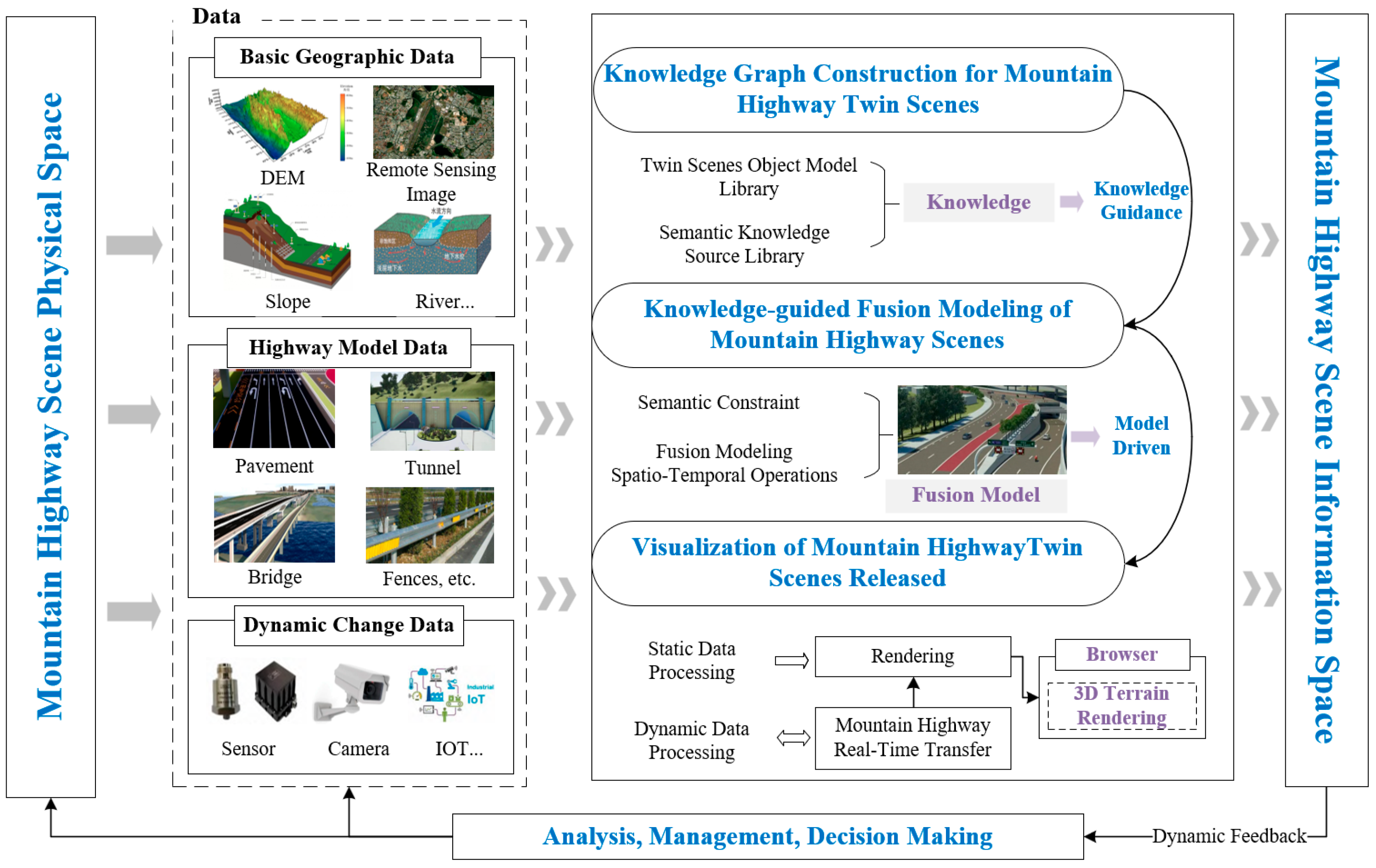
2.1. Overall Research Idea
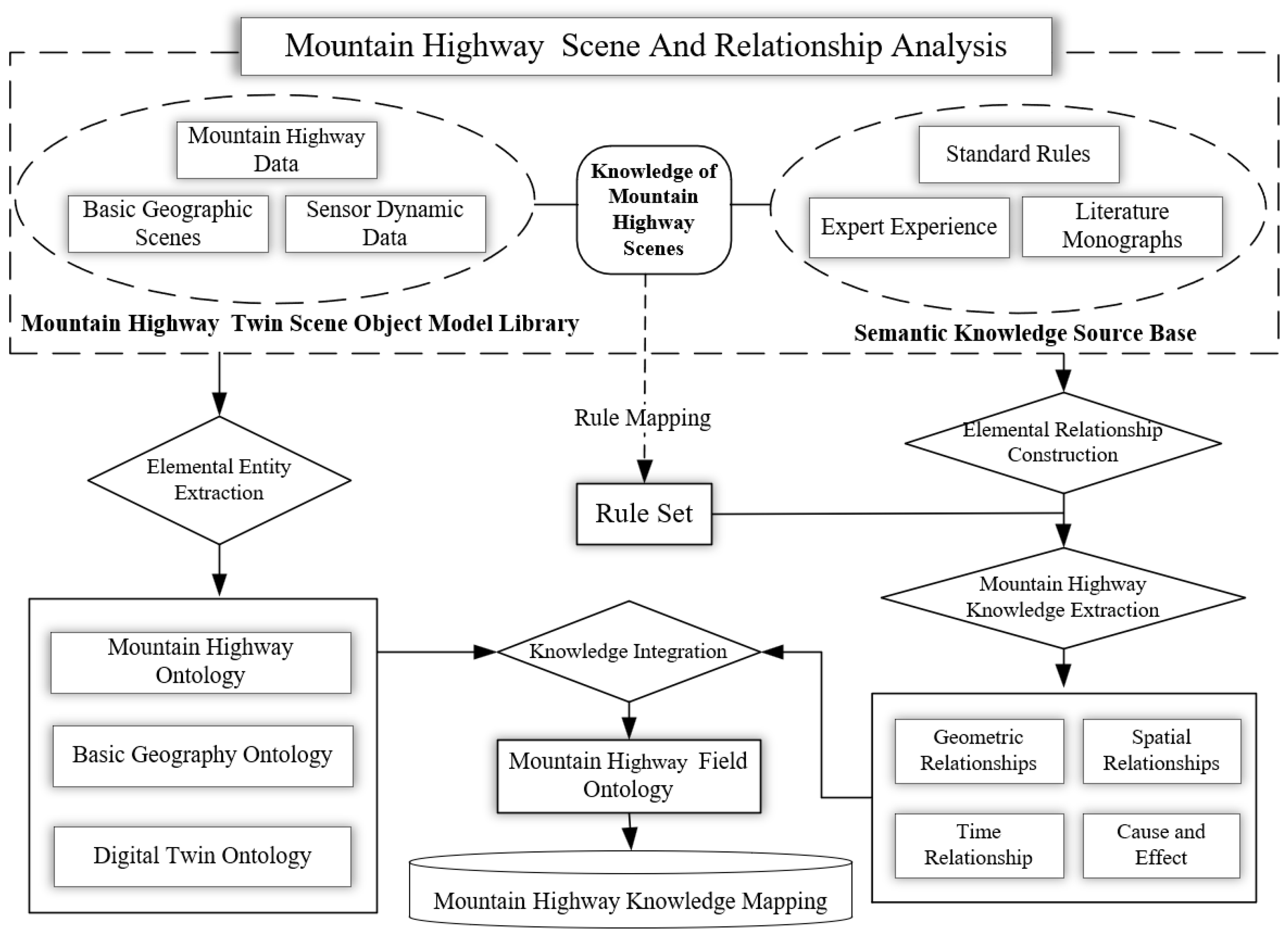
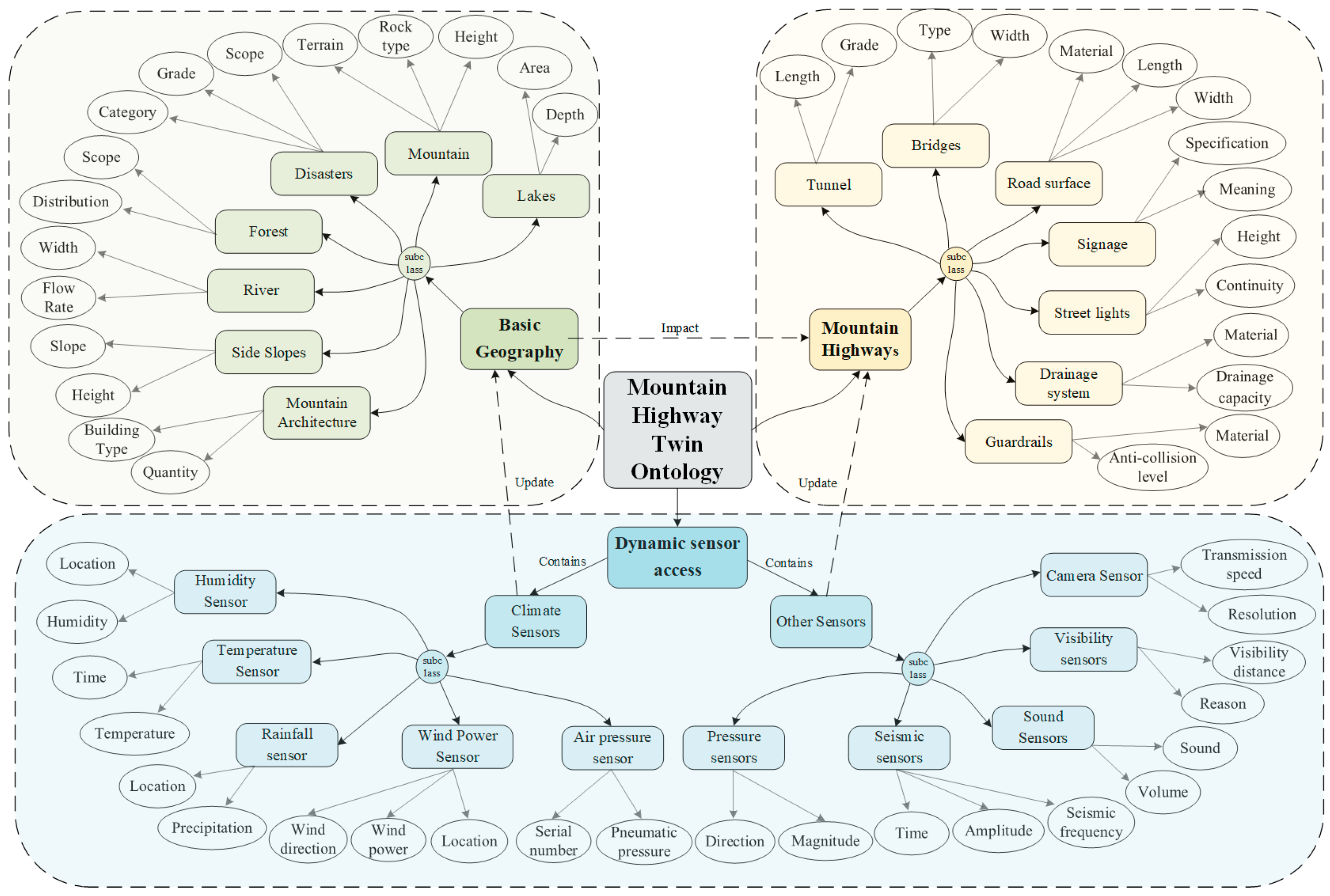
2.2. Knowledge Graph Construction for Mountain Highway Twin Scenes
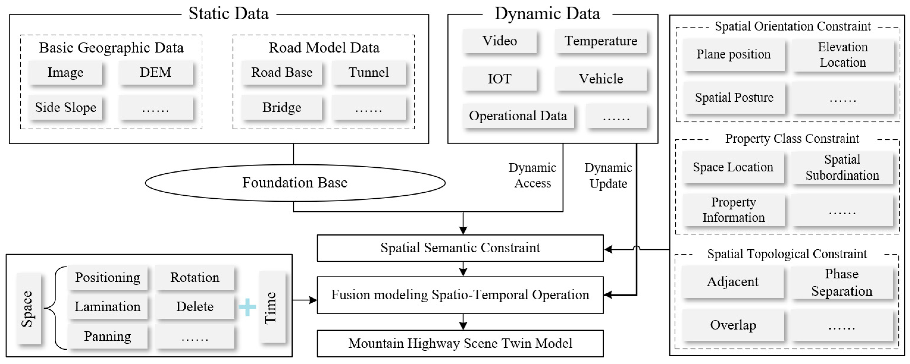
2.3. Knowledge-Guided Fusion Modeling of Mountain Highway Scenes
2.3.1. Spatial Semantic Constraints Rules
- (1)
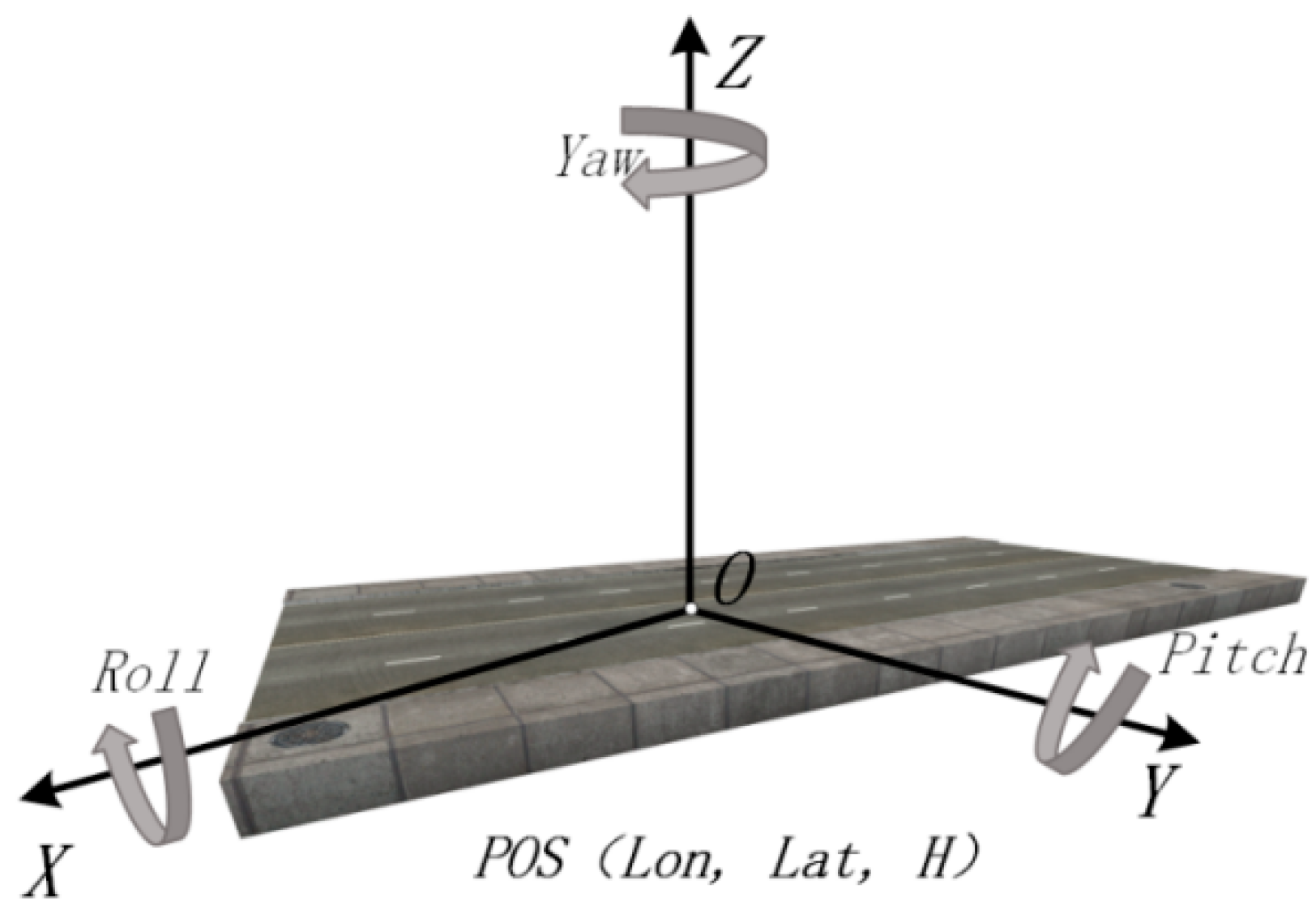
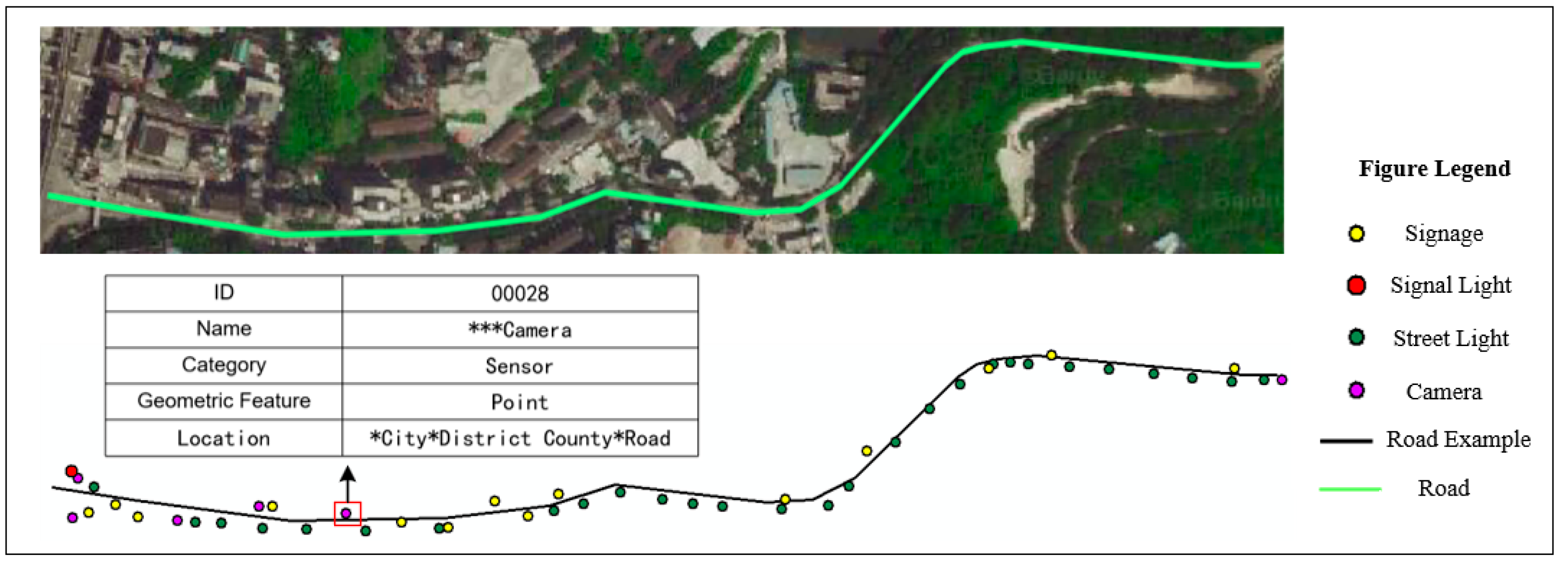
- Spatial Orientation constraints
- (2)
- Attribute Category Constraints
- (3)
- Spatial Topological Constraints
2.3.2. Fusion Modeling of Mountain Highway Scenes
- (1)
- Symbolic Modeling of Sensors
- (2)
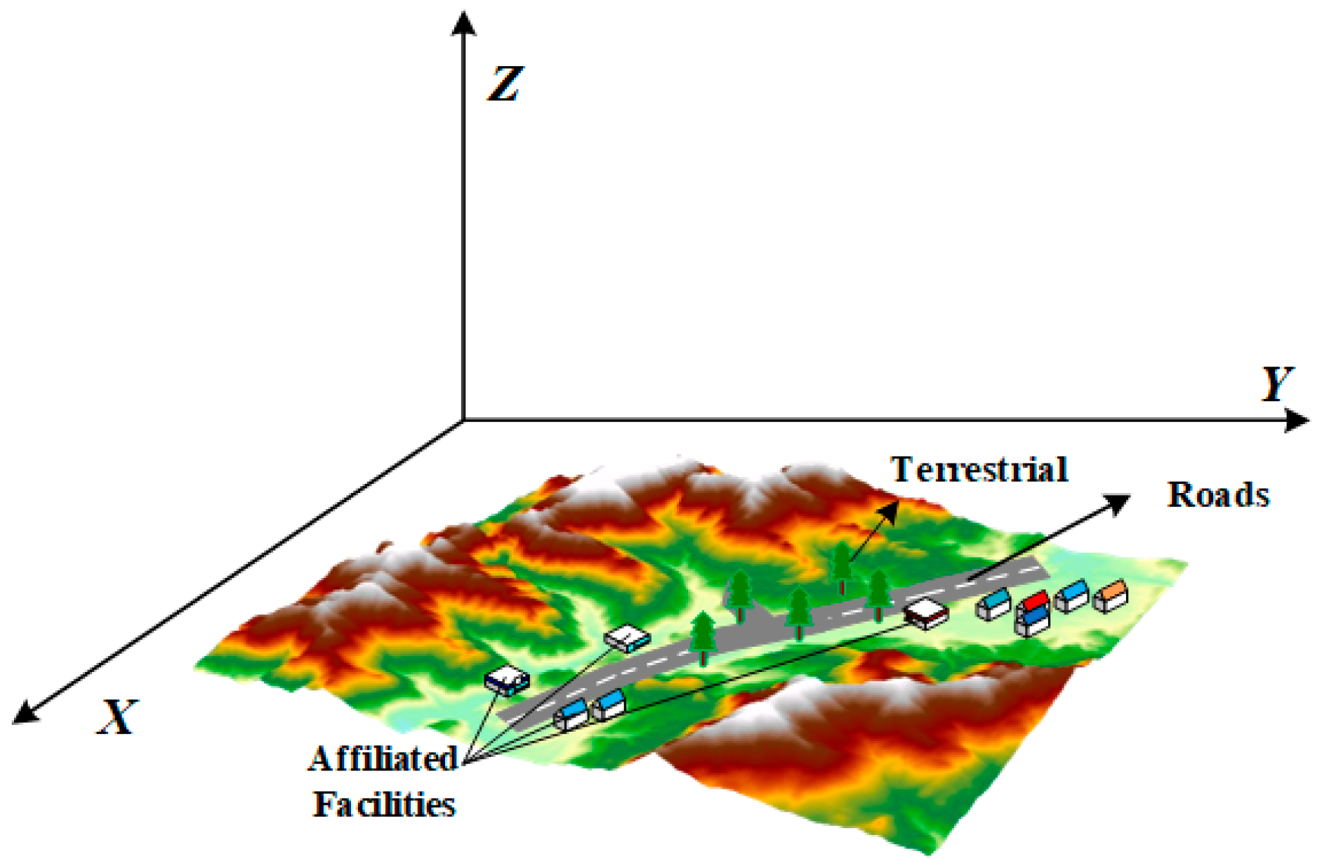
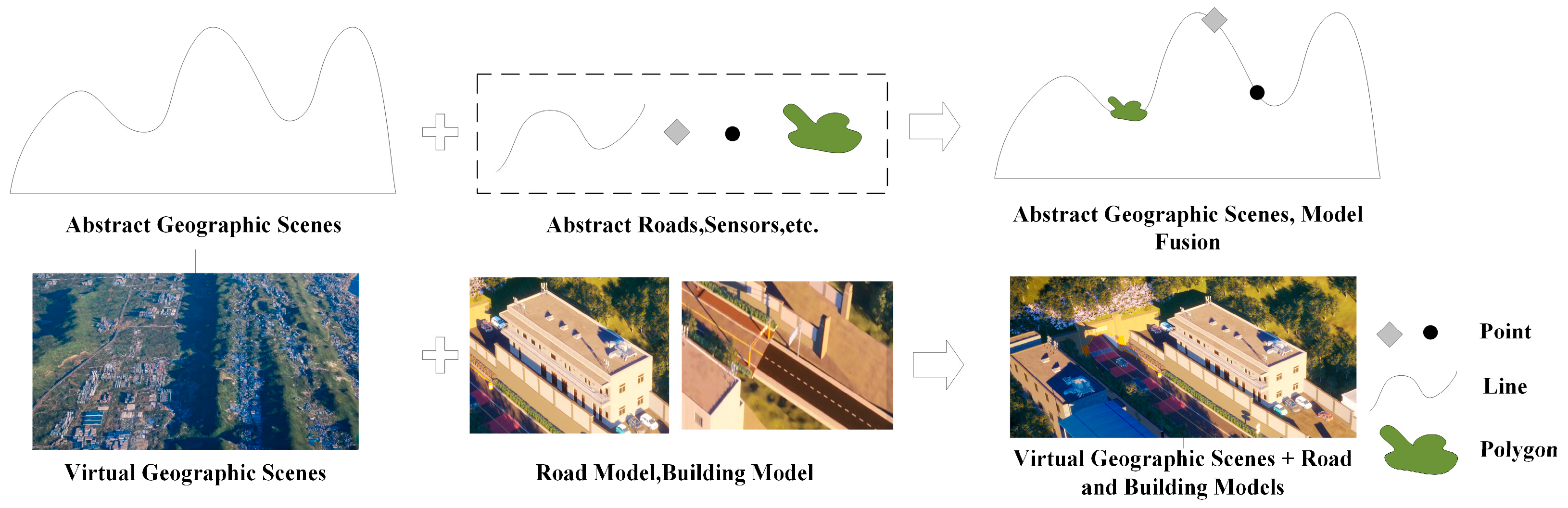
- Fusion Processing of Terrain and Highway Models
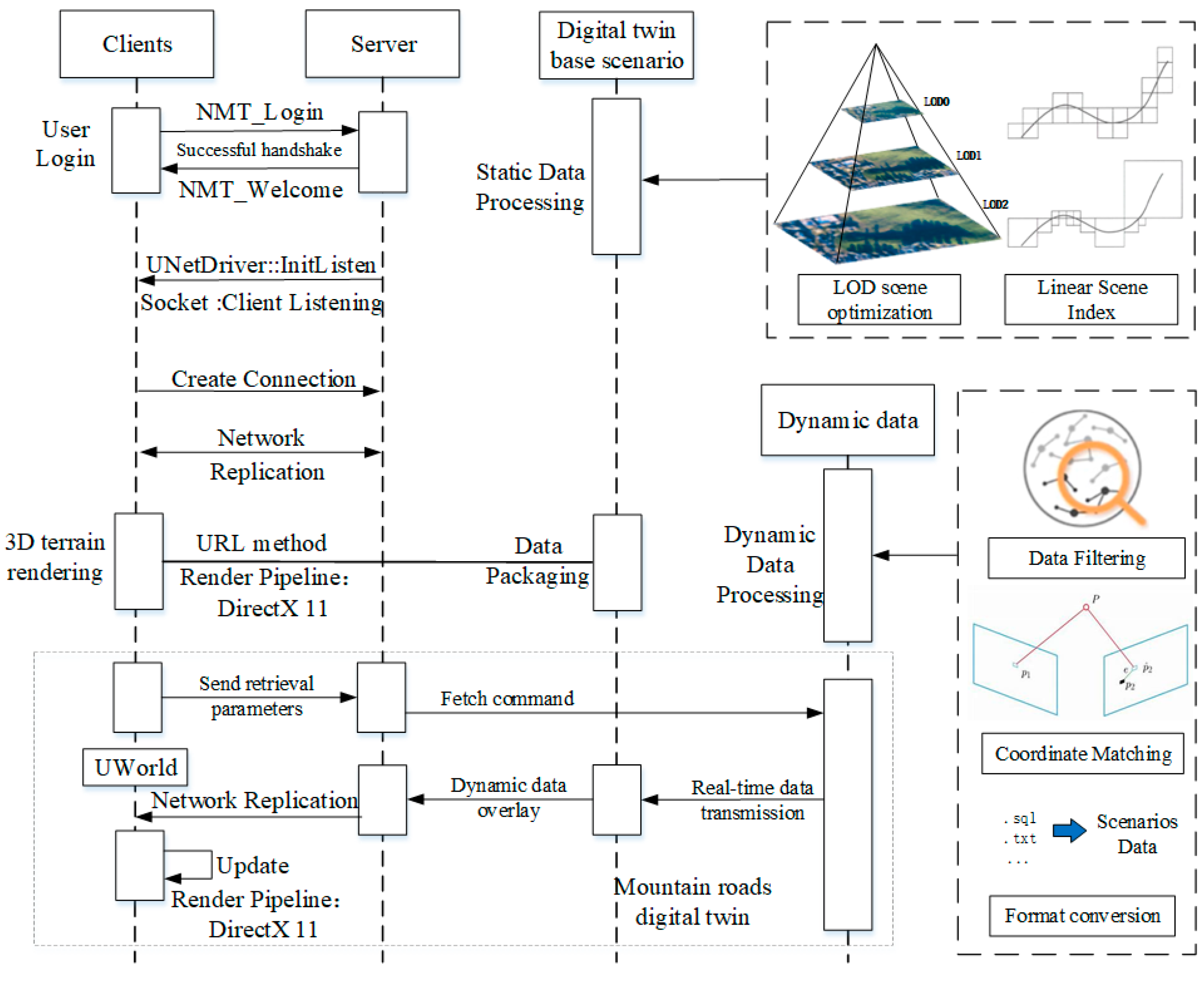
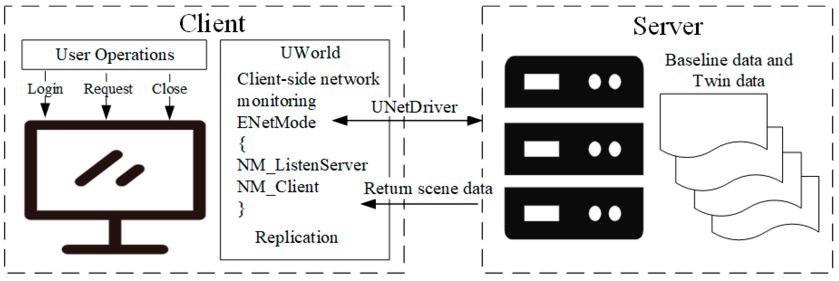
2.4. Visualisation of Mountain Highway Twin Scenes
2.4.1. Digital Twin Base Scenario Optimization and Visual Display
2.4.2. Digital Twin Dynamic Data Access and Visual Presentation
3. Experiment and Analysis
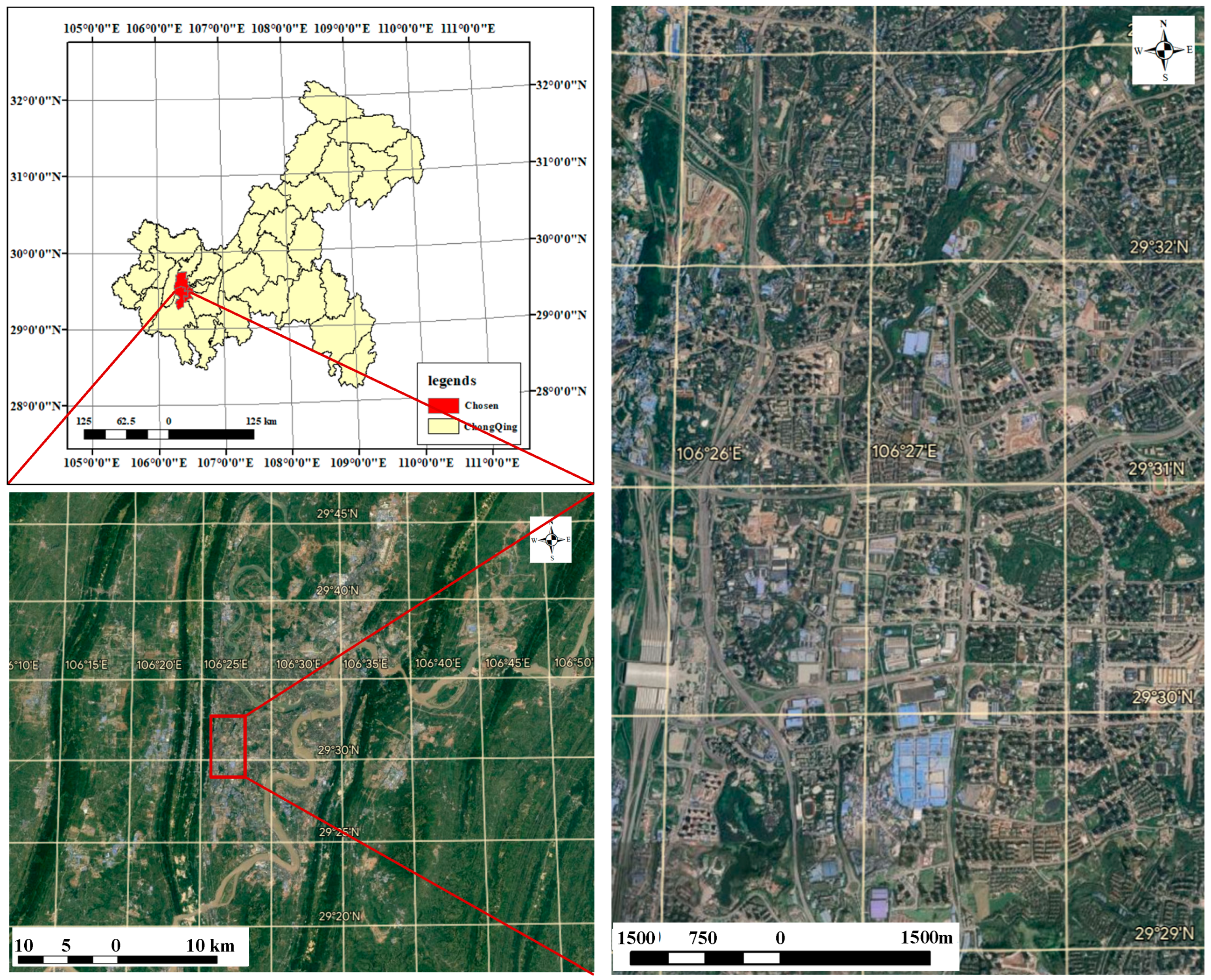
3.1. Case Study
3.2. Prototype System
3.2.1. Development Environment
3.2.2. System Interface Introduction
- (1)
- Basic Geographic Data
- (2)
- Highway Model Data
- (3)
- Dynamic Data
3.2.3. System Interface Introduction
3.3. Case Experiment Analysis
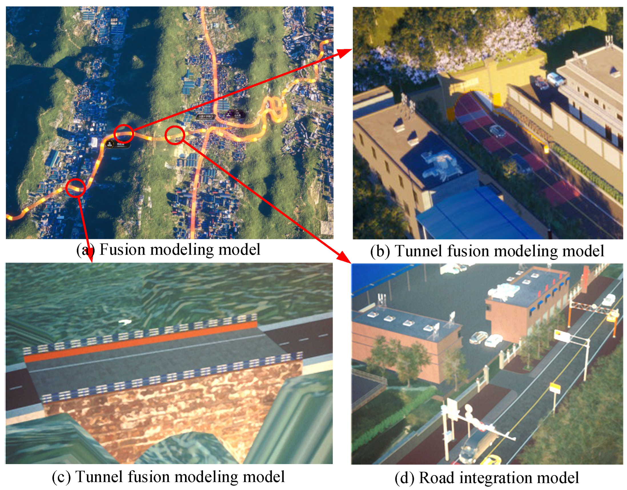
3.3.1. Mountain Highway Integration Modeling
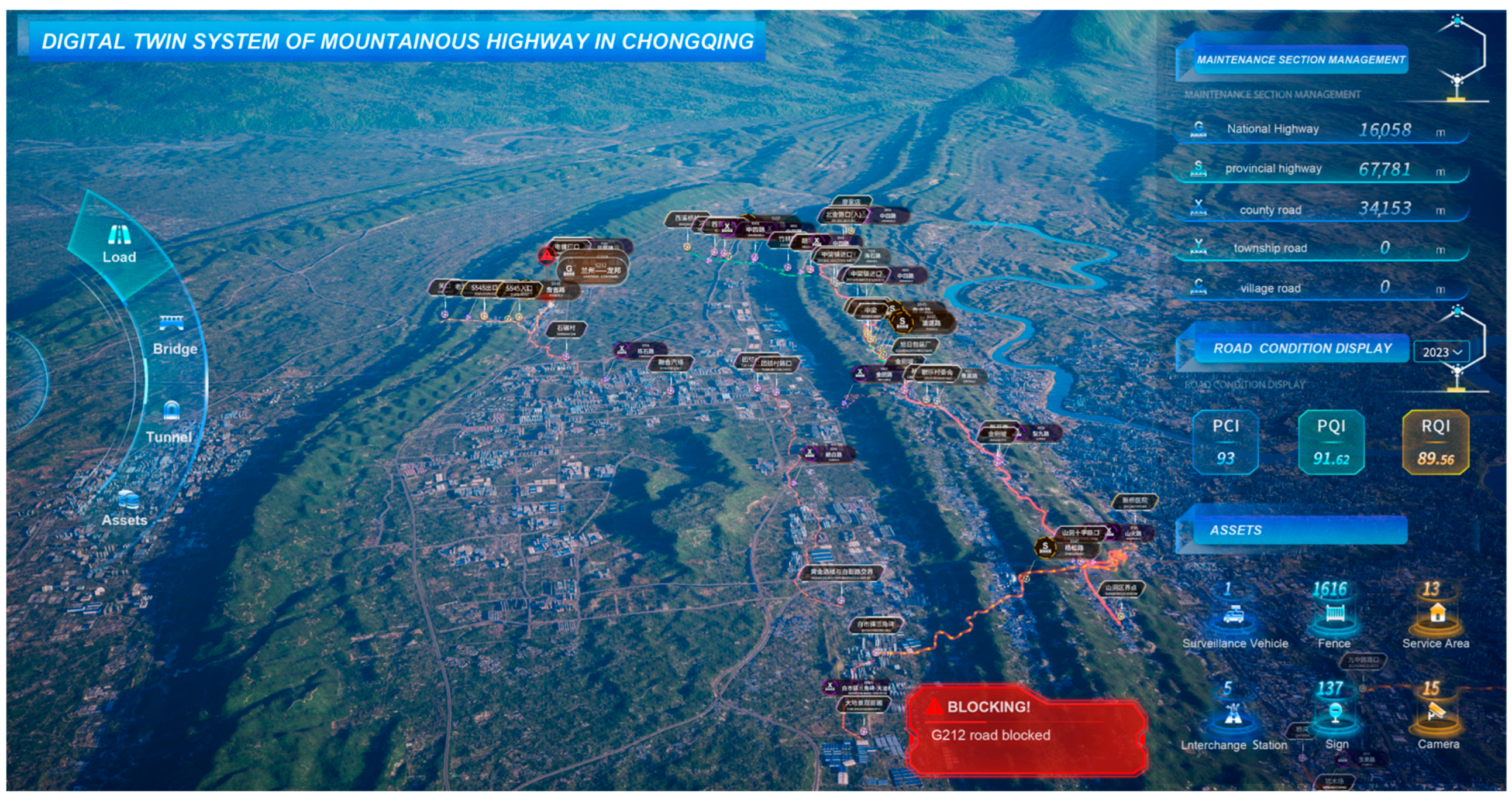
3.3.2. Dynamic Expression of the Scene
- (1)
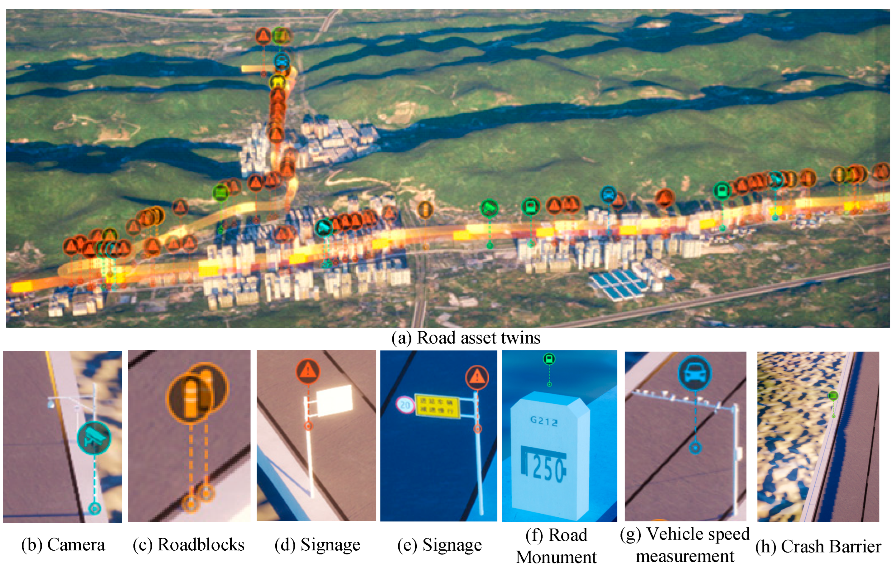
- Road Asset Management
- (2)
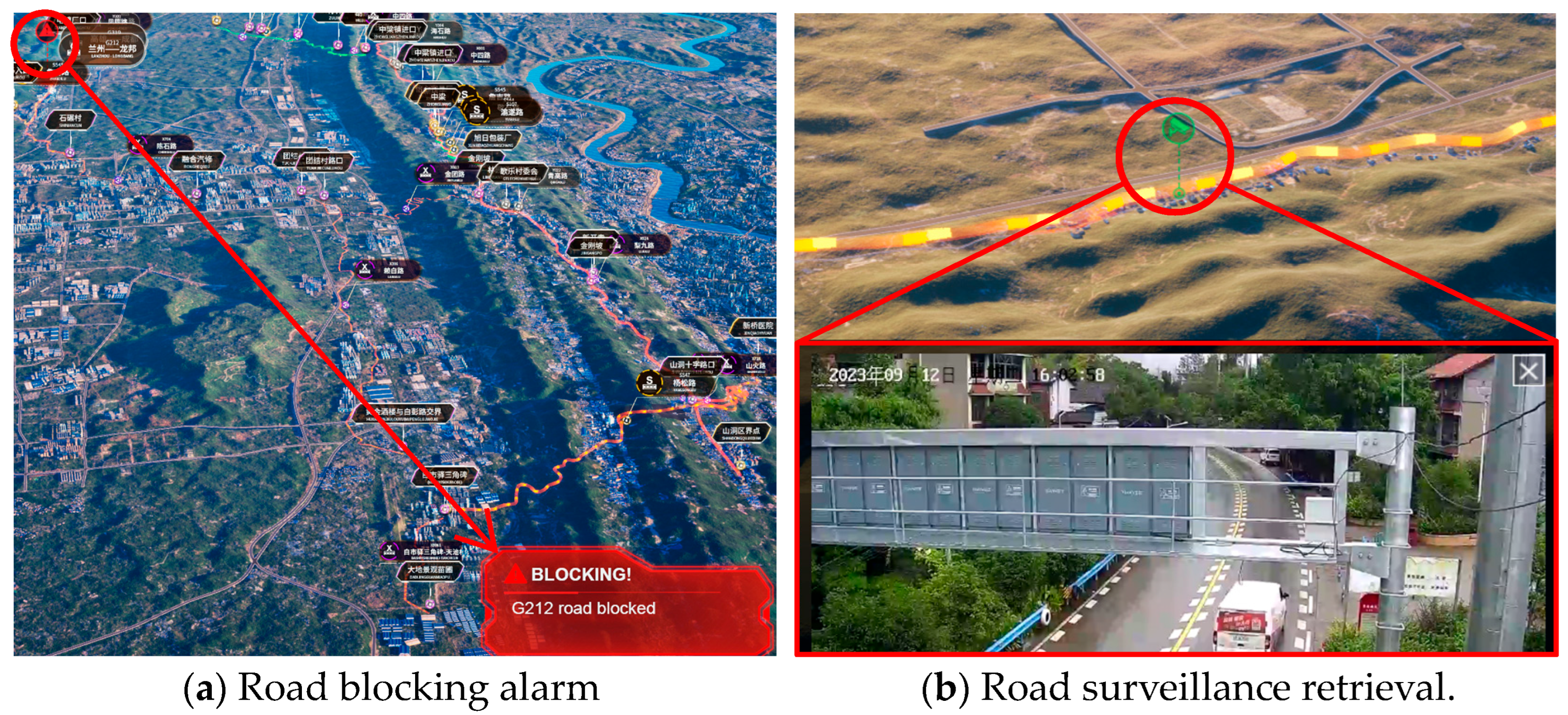
- Road condition monitoring
- (3)
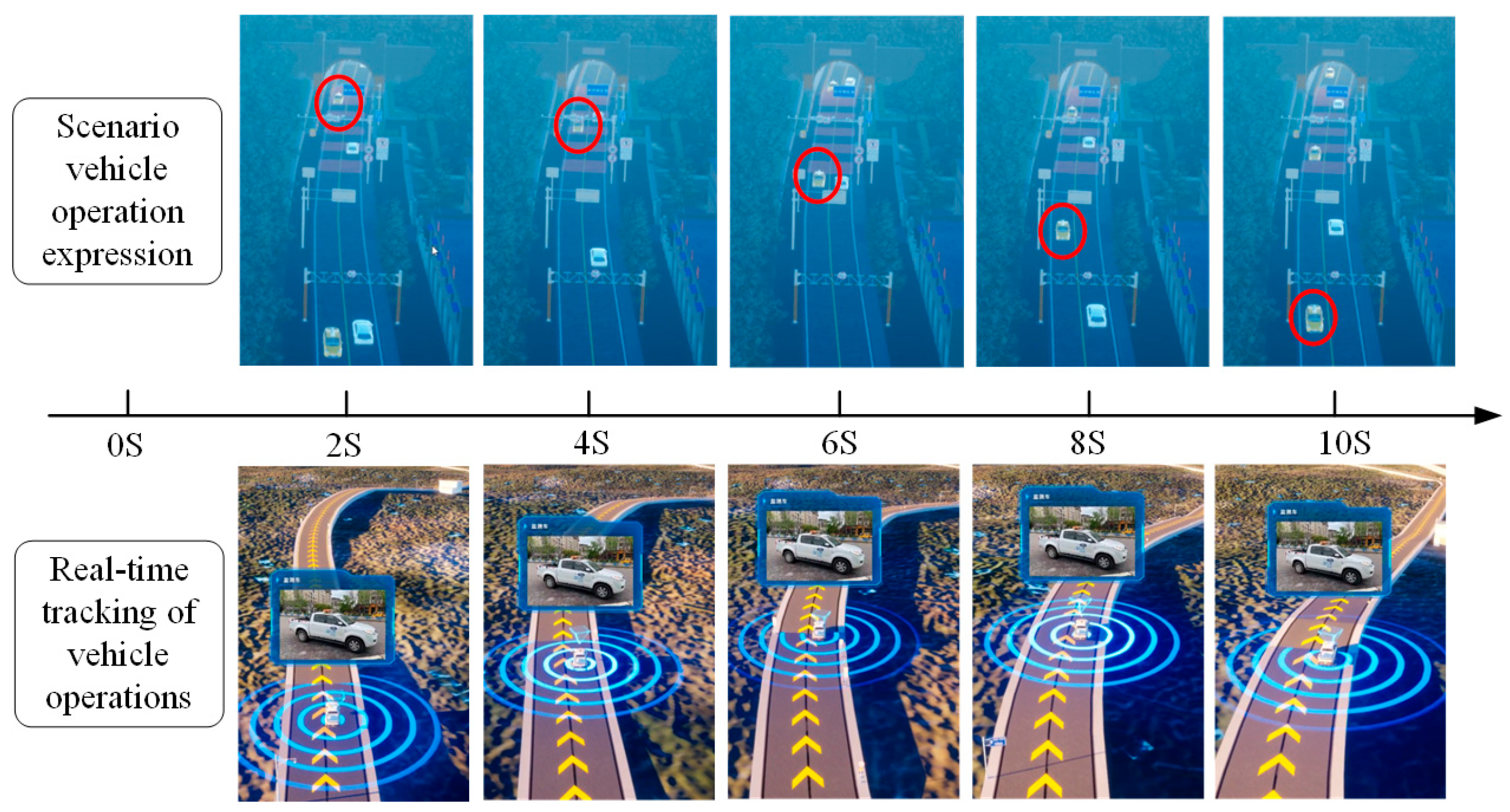
- Dynamic Monitoring of Vehicle Information
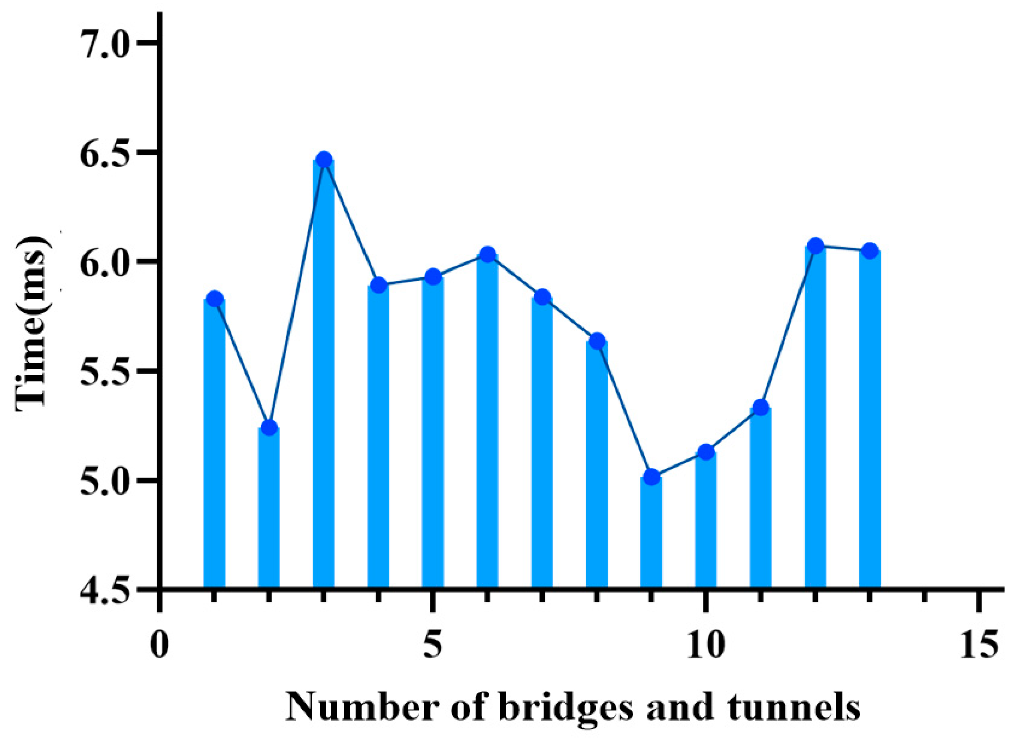
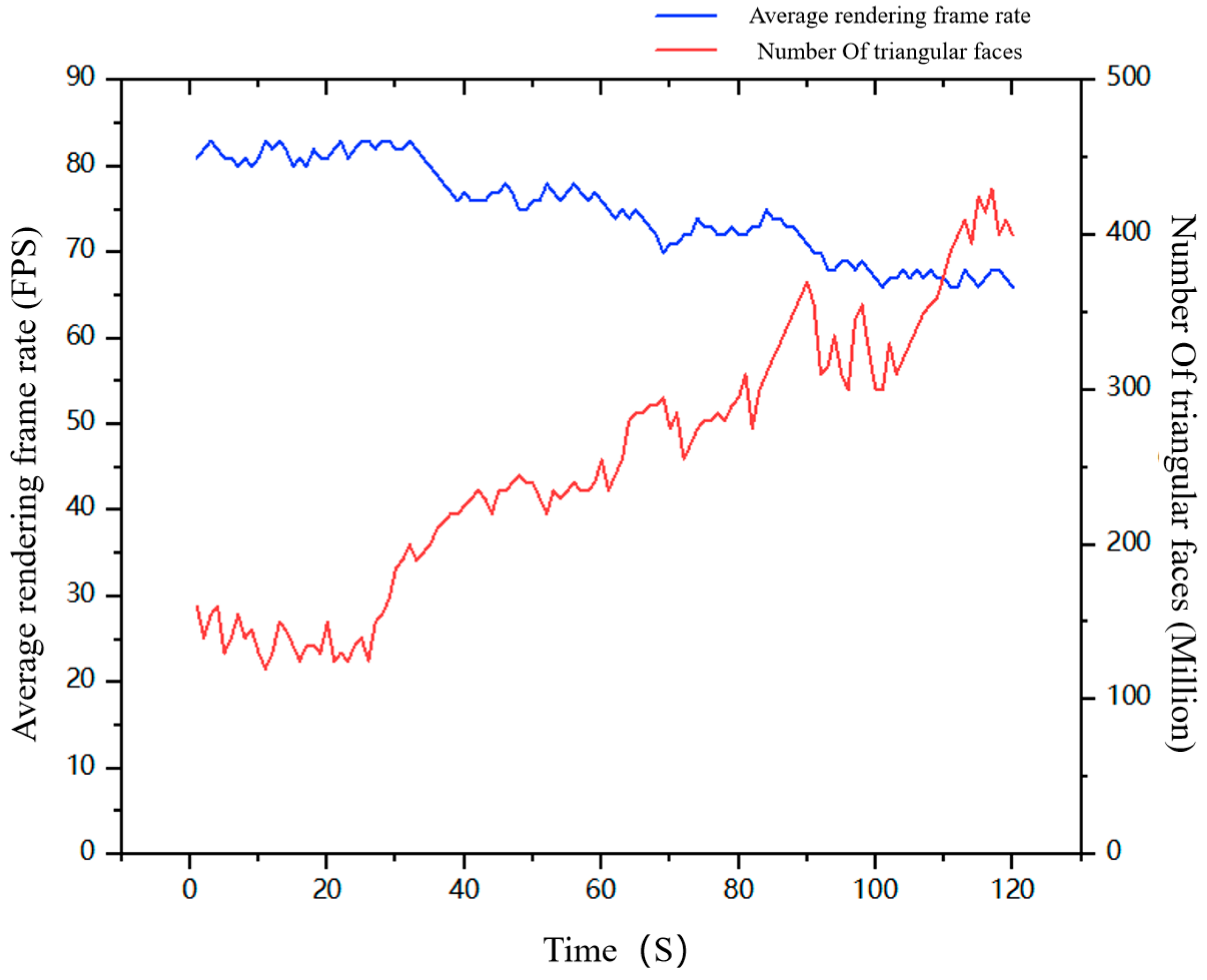
3.3.3. Scene Rendering Efficiency
3.3.4. Comparison of Existing Digital Twin Visualisation Methods
4. Discussion
4.1. Strengths
4.2. Limitations
4.3. Suggestions
5. Conclusions and Future Work
Author Contributions
Funding
Data Availability Statement
Acknowledgments
Conflicts of Interest
References
- Courtial, A.; El Ayedi, A.; Touya, G.; Zhang, X. Exploring the potential of deep learning segmentation for mountain roads generalisation. ISPRS Int. J. Geo-Inf. 2020, 9, 338. [Google Scholar] [CrossRef]
- Courtial, A.; Touya, G.; Zhang, X. Deriving map images of generalised mountain roads with generative adversarial networks. Int. J. Geogr. Inf. Sci. 2023, 37, 499–528. [Google Scholar] [CrossRef]
- Vega-Zamanillo, Á.; Juli-Gándara, L.; Calzada-Pérez, M.A.; Teijón-López-Zuazo, E. Study on the conservation of bituminous mixes in high mountain roads and coastal zones. Transp. Res. Procedia 2021, 58, 325–332. [Google Scholar] [CrossRef]
- Xia, H.; Liu, Z.; Maria, E.; Xiaotong, L.; Chunxiang, L. Study on city digital twin technologies for sustainable smart city de-sign: A review and bibliometric analysis of geographic information system and building information modeling integration. Sustain. Cities Soc. 2022, 84, 104009. [Google Scholar] [CrossRef]
- Gong, S.; Hua, G. Decision making analysis of traffic accidents on mountain roads in Yunnan province. In Proceedings of the International Conference on Machine Learning for Cyber Security, Nanjing, China, 3–5 March 2023; pp. 228–237. [Google Scholar] [CrossRef]
- Sofia, H.; Anas, E.; Faïz, O. Mobile mapping, machine learning and digital Twin for road infrastructure monitoring and maintenance: Case study of mohammed VI bridge in Morocco. In Proceedings of the International Conference of Moroccan Geomatics, Casablanca, Morocco, 11–13 May 2020. [Google Scholar]
- Jones, D.; Snider, C.; Nassehi, A.; Yon, J.; Hicks, B. Characterising the Digital Twin: A systematic literature review. CIRP J. Manuf. Sci. Technol. 2020, 29, 36–52. [Google Scholar] [CrossRef]
- Liu, M.; Fang, S.; Dong, H.; Xu, C. Review of digital twin about concepts, technologies, and industrial applications. J. Manuf. Syst. 2021, 58, 346–361. [Google Scholar] [CrossRef]
- Bauer, P.; Stevens, B.; Hazeleger, W. A digital twin of Earth for the green transition. Nat. Clim. Chang. 2021, 11, 80–83. [Google Scholar] [CrossRef]
- Voosen, P. Europe builds ‘digital twin’ of Earth to hone climate forecasts. Science 2020, 370, 16–17. [Google Scholar] [CrossRef]
- Li, Y.; Zhang, W. Traffic flow digital twin generation for highway scenario based on radar-camera paired fusion. Sci. Rep. 2023, 13, 642. [Google Scholar] [CrossRef]
- Zheng, Y.; Yang, S.; Cheng, H. An application framework of digital twin and its case study. J. Ambient. Intell. Humaniz. Comput. 2019, 10, 1141–1153. [Google Scholar] [CrossRef]
- Tao, F.; Xiao, B.; Qi, Q.; Cheng, J.; Ji, P. Digital twin modeling. J. Manuf. Syst. 2022, 64, 372–389. [Google Scholar] [CrossRef]
- Lu, S.; Fang, C.; Xiao, X. Virtual scene construction of wetlands: A case study of Poyang Lake, China. Int. J. Geo-Inf. 2023, 12, 49. [Google Scholar] [CrossRef]
- Li, W.; Zhu, J.; Dang, P.; Wu, J.; Zhang, J.; Fu, L.; Zhu, Q. Immersive virtual reality as a tool to improve bridge teaching communication. Expert Syst. Appl. 2023, 217, 119502. [Google Scholar] [CrossRef]
- Dang, P.; Zhu, J.; Qiao, X.; Wu, J.; Li, W.; You, J.; Fu, L. How does spatial cognitive style affect indoor fire evacuation way-finding in mobile virtual reality? Cartogr. Geogr. Inf. Sci. 2023, 50, 272–288. [Google Scholar] [CrossRef]
- Dang, P.; Zhu, J.; Pirasteh, S.; Li, W.; You, J.; Xu, B.; Liang, C. A chain navigation grid based on cellular automata for large-scale crowd evacuation in virtual reality. Int. J. Appl. Earth Obs. Geoinf. 2021, 103, 102507. [Google Scholar] [CrossRef]
- Fu, L.; Zhu, J.; Li, W.; Zhu, Q.; Xu, B.; Xie, Y.; Zhang, Y.; Hu, Y.; Lu, J.; Dang, P.; et al. Tunnel vision optimization method for VR flood scenes based on Gaussian blur. Int. J. Digit. Earth 2021, 14, 821–835. [Google Scholar] [CrossRef]
- Semeraro, C.; Lezoche, M.; Panetto, H.; Dassisti, M. Digital twin paradigm: A systematic literature review. Comput. Ind. 2021, 130, 103469. [Google Scholar] [CrossRef]
- Li, L.; Lei, B.; Mao, C. Digital twin in smart manufacturing. J. Ind. Inf. Integr. 2022, 26, 100289. [Google Scholar] [CrossRef]
- Avila, A.M.; Mezić, I. Data-driven analysis and forecasting of highway traffic dynamics. Nat. Commun. 2020, 11, 2090. [Google Scholar] [CrossRef]
- Shahat, E.; Hyun, C.T.; Yeom, C. City digital twin potentials: A review and research agenda. Sustainability 2021, 13, 3386. [Google Scholar] [CrossRef]
- Liao, Z.; Huang, H.; Zhao, Y.; Liu, Y.; Zhang, G. Analysis and Forecast of Traffic Flow between Urban Functional Areas Based on Ride-Hailing Trajectories. ISPRS Int. J. Geo-Inf. 2023, 12, 144. [Google Scholar] [CrossRef]
- Feng, Y.; Ge, N.; Tao, X.; Song, Q.; Xiang, T. Channel Modelling for V2V Highway Scenario Based on Birth and Death Process. Wirel. Commun. Mob. Comput. 2022, 2022, 3384362. [Google Scholar] [CrossRef]
- Li, W.; Zhu, J.; Pirasteh, S.; Zhu, Q.; Fu, L.; Wu, J.; Hu, Y.; Dehbi, Y. Investigations of disaster information representation from a geospatial perspective: Progress, challenges and recommendations. Trans. GIS 2022, 26, 1376–1398. [Google Scholar] [CrossRef]
- Li, W.; Zhu, J.; Fu, L.; Zhu, Q.; Xie, Y.; Hu, Y. An augmented representation method of debris flow scenes to improve public perception. Int. J. Geogr. Inf. Sci. 2021, 35, 1521–1544. [Google Scholar] [CrossRef]
- Zhu, X.; Chen, J.; Gao, F.; Chen, X.; Masek, J.G. An enhanced spatial and temporal adaptive reflectance fusion model for complex heterogeneous regions. Remote Sens. Environ. 2010, 114, 2610–2623. [Google Scholar] [CrossRef]
- Esteban, J.; Starr, A.; Willetts, R.; Hannah, P.; Bryanston-Cross, P. A Review of data fusion models and architectures: Towards engineering guidelines. Neural Comput. Appl. 2005, 14, 273–281. [Google Scholar] [CrossRef]
- Majumder, N.; Hazarika, D.; Gelbukh, A.; Cambria, E.; Poria, S. Multimodal sentiment analysis using hierarchical fusion with context modeling. Knowl. Based Syst. 2018, 161, 124–133. [Google Scholar] [CrossRef]
- Zhang, J.; Zhu, J.; Dang, P.; Wu, J.; Zhou, Y.; Li, W.; Fu, L.; Guo, Y.; You, J. An improved social force model (ISFM)-based crowd evacuation simulation method in virtual reality with a subway fire as a case study. Int. J. Digit. Earth 2023, 16, 1186–1204. [Google Scholar] [CrossRef]
- Wu, J.; Zhu, J.; Zhang, J.; Dang, P.; Li, W.; Guo, Y.; Fu, L.; Lai, J.; You, J.; Xie, Y.; et al. A dynamic holographic modelling method of digital twin scenes for bridge construction. Int. J. Digit. Earth 2023, 16, 2404–2425. [Google Scholar] [CrossRef]
- Dang, P.; Zhu, J.; Zhou, X.; Rao, Y.; You, J.; Wu, J.; Zhang, M.; Li, W. A 3D-Panoramic fusion flood enhanced visualization method for VR. Environ. Model. Softw. 2023, 169, 105810. [Google Scholar] [CrossRef]
- Xie, Y.; Feng, D.; Chen, H.; Lai, Z.; Zhu, J.; Li, C.; Sung, W.B. An Omni-scale Global-Local Aware Network for Shadow Ex-traction in Remote Sensing Imagery. ISPRS J. Photogramm. Remote Sens. 2022, 193, 29–44. [Google Scholar] [CrossRef]
- Bakshi, N.; Shivani, S.; Tiwari, S.; Khurana, M. Optimized Z-Buffer Using Divide and Conquer. In Innovations in Computational Intelligence and Computer Vision: Proceedings of ICICV; Springer: Singapore, 2021; Volume 2020, pp. 41–47. [Google Scholar]
- Hänel, M.L.; Völkel, J.; Henrich, D. Multi camera placement via Z-buffer rendering for the optimization of the coverage and the visual hull. arXiv 2021, arXiv:2103.11211. [Google Scholar]
- Luo, G.; Wang, R.; Wu, H.; Zhao, X.; Huang, X.; Cao, Y.; Liao, C. Fast hidden line removal method for large-scale 3D substa-tion scene model based on Z-buffer algorithm optimization. J. Graph. 2021, 42, 775. [Google Scholar]
- Polis, M.F.; Gifford, S.J.; MckKeown, D.M. Automating the construction of large-scale virtual worlds. Computer 1995, 28, 57–65. [Google Scholar] [CrossRef]
- Papandreou, G.; Zhu, T.; Chen, L.-C.; Gidaris, S.; Tompson, J.; Murphy, K. PersonLab: Person pose Estimation and instance segmentation with a bottom-up, part-based, geometric embedding model. In Proceedings of the European Conference on Computer Vision (ECCV), Munich, Germany, 8–14 September 2018; pp. 282–299. [Google Scholar] [CrossRef]
- Wu, H.; Yan, Y.; Ye, Y.; Ng, M.K.; Wu, Q. Geometric knowledge embedding for unsupervised domain adaptation. Knowl. Based Syst. 2020, 191, 105155. [Google Scholar] [CrossRef]
- Chen, B.; Huang, B.; Xu, B. Comparison of spatiotemporal fusion models: A review. Remote Sens. 2015, 7, 1798–1835. [Google Scholar] [CrossRef]
- Zhao, X.; Zhan, P.; Liu, Y. Rapid construction algorithm of 3D urban road network from raster maps. In Proceedings of the International Conference on Virtual Reality and Visualization (ICVRV), Zhengzhou, China, 21–22 October 2017. [Google Scholar]
- Solovyev, R.; Wang, W.; Gabruseva, T. Weighted boxes fusion: Ensembling boxes from different object detection models. Image Vis. Comput. 2021, 107, 104117. [Google Scholar] [CrossRef]
- Chen, J.; Liu, T.; Hou, X. Virtual globe-oriented visualization method of multi-scale vector data. Wuhan Daxue Sxuebao (Xinxi Kexue Ban)/Geomat. Inf. Sci. Wuhan Univ. 2015, 40, 1195–1200. [Google Scholar]
- Dinçer, S.G.; Yazar, T. A comparative analysis of the digital re-constructions of muqarnas systems: The case study of Sultanhanı muqarnas in Central Anatolia. Int. J. Arch. Comput. 2021, 19, 360–385. [Google Scholar] [CrossRef]
- Huo, Y.; Yang, A.; Jia, Q.; Chen, Y.; He, B.; Li, J. Efficient visualization of large-scale oblique photogrammetry models in un-real engine. ISPRS Int. J. Geo-Inf. 2021, 10, 643. [Google Scholar] [CrossRef]
- You, J.; Zhu, J.; Li, W.; Guo, Y.; Fu, L.; Dang, P. ROI-constrained visualization of flood scenes to improve perception efficiency. Int. J. Digit. Earth 2023, 16, 3065–3084. [Google Scholar] [CrossRef]
- Tiwari, S.; Al-Aswadi, F.N.; Gaurav, D. Recent trends in knowledge graphs: Theory and practice. Soft Comput. 2021, 25, 8337–8355. [Google Scholar] [CrossRef]
- Zhu, Y.; Wang, X.; Chen, J.; Qiao, S.; Ou, Y.; Yao, Y.; Deng, H.; Chen, H.; Zhang, N. LLMs for Knowledge Graph Construc-tion and Reasoning: Recent Capabilities and Future Opportunities. arXiv 2023, arXiv:2305.13168. [Google Scholar]
- Verma, S.; Bhatia, R.; Harit, S.; Batish, S. Scholarly knowledge graphs through structuring scholarly communication: A review. Complex Intell. Syst. 2023, 9, 1059–1095. [Google Scholar] [CrossRef] [PubMed]
- Lai, J.B.; Zhu, J.; Luo, N.Y.; Zhang, Y.; Zuo, L.; Guo, Y.K.; You, J.G. Visual supervision of large-scope heat source factories based on knowledge graph. Trans. GIS 2023, 27, 408–424. [Google Scholar] [CrossRef]
- Lai, J.; Zhu, J.; Chai, J.; Xu, B. Spatial-temporal analysis of industrial heat and productivity in China. Appl. Geogr. 2022, 138, 102618. [Google Scholar] [CrossRef]
- Xie, Y.; Zhu, J.; Lai, J.; Wang, P.; Feng, D.; Cao, Y.; Hussain, T.; Baik, S.W. An enhanced relation-aware global-local attention network for escaping human detection in indoor smoke scenarios. ISPRS J. Photogramm. Remote Sens. 2022, 186, 140–156. [Google Scholar] [CrossRef]
- Xie, Y.; Feng, D.; Shen, X.; Liu, Y.; Zhu, J.; Hussain, T.; Baik, S.W. Clustering feature constraint multiscale attention network for shadow extraction from remote sensing images. IEEE Trans. Geosci. Remote Sens. 2022, 15, 1–4. [Google Scholar] [CrossRef]
- Ryen, V.; Soylu, A.; Roman, D. Building semantic knowledge graphs from (Semi-)structured data: A review. Futur. Internet 2022, 14, 129. [Google Scholar] [CrossRef]
- Issa, S.; Adekunle, O.; Hamdi, F.; Cherfi, S.S.-S.; Dumontier, M.; Zaveri, A. Knowledge Graph Completeness: A Systematic Literature Review. IEEE Access 2021, 9, 31322–31339. [Google Scholar] [CrossRef]
- Guo, Y.; Zhu, J.; You, J.; Pirasteh, S.; Li, W.; Wu, J.; Lai, J.; Dang, P. A dynamic visualization based on conceptual graphs to capture the knowledge for disaster education on floods. Nat. Hazards 2023, 119, 203–220. [Google Scholar] [CrossRef]
- Sun, T.; Cao, Y.; Mao, B. 3D city cadaster data visualization and viewer behavior analysis in virtual reality environment. In Proceedings of the 2020 IEEE/WIC/ACM International Joint Conference on Web Intelligence and Intelligent Agent Technology (WI-IAT), Melbourne, VIC, Australia, 14–17 December 2020. [Google Scholar]
- Zhang, Y.; Wang, Y.; Li, M.; Mao, B. Online 3D electricity infrastructure visualization based on cesium framework. In Proceedings of the IEEE/WIC/ACM International Conference on Web Intelligence and Intelligent Agent Technology, Melbourne, VIC, Australia, 14–17 December 2021. [Google Scholar]
- Wen, F.K.; Wen, L.G.; Juan, Y.X.; Yang, P.L.; Yu, T.Y. 3D visualization of urban underground pipelines by using Super-Map. In Proceedings of the IOP Conference Series: Earth and Environmental Science, Kuala Lumpur, Malaysia, 24 May 2019. [Google Scholar]


| Specifications | Specifications Information | |
|---|---|---|
| Hardware | CPU | Inter i7-12700H |
| Memory | 16G | |
| Video Cards | NVIDIA GTX 3060 | |
| Video Memory | 6G | |
| Software | PC-based system | Windows11 |
| Software | UE4.27 | |
| VS2017 |
Disclaimer/Publisher’s Note: The statements, opinions and data contained in all publications are solely those of the individual author(s) and contributor(s) and not of MDPI and/or the editor(s). MDPI and/or the editor(s) disclaim responsibility for any injury to people or property resulting from any ideas, methods, instructions or products referred to in the content. |
© 2023 by the authors. Licensee MDPI, Basel, Switzerland. This article is an open access article distributed under the terms and conditions of the Creative Commons Attribution (CC BY) license (https://creativecommons.org/licenses/by/4.0/).
Share and Cite
Tang, R.; Zhu, J.; Ren, Y.; Ding, Y.; Wu, J.; Guo, Y.; Xie, Y. A Knowledge-Guided Fusion Visualisation Method of Digital Twin Scenes for Mountain Highways. ISPRS Int. J. Geo-Inf. 2023, 12, 424. https://doi.org/10.3390/ijgi12100424
Tang R, Zhu J, Ren Y, Ding Y, Wu J, Guo Y, Xie Y. A Knowledge-Guided Fusion Visualisation Method of Digital Twin Scenes for Mountain Highways. ISPRS International Journal of Geo-Information. 2023; 12(10):424. https://doi.org/10.3390/ijgi12100424
Chicago/Turabian StyleTang, Ranran, Jun Zhu, Ying Ren, Yongzhe Ding, Jianlin Wu, Yukun Guo, and Yakun Xie. 2023. "A Knowledge-Guided Fusion Visualisation Method of Digital Twin Scenes for Mountain Highways" ISPRS International Journal of Geo-Information 12, no. 10: 424. https://doi.org/10.3390/ijgi12100424