1. Introduction
The problem of deformation control of an excavation retaining wall has become the core problem of deep excavation projects in prosperous urban areas. The excavation retaining structure is a temporary structure with distinct regional characteristics. And excavation engineering is a highly practical engineering application. Each city should actively collect the data of excavation cases in their own areas and establish an excavation case deformation database guided by local regional experience, so as to guide the subsequent design and construction of excavations in their regions.
Peck [
1] has collected worldwide excavation examples and summarized the influencing factors of excavation deformation since 1969. Many scholars (such as Clough, Ou, Long, Yoo, and Moormann [
2,
3,
4,
5,
6]) followed the same approach to research behaviors of excavation engineering, including the main deformation forms of excavations, the zoning of excavation deformation affected areas, and the main factors affecting excavation deformation.
Establishing a regional excavation deformation database can clarify the reasonable scheme for the design and construction of excavations in the region, draw on deformation control indicators, and predict the deformation impact areas outside of excavations.
With the development of the economy, the application of deep excavation cases in China was increasing day by day. Chinese scholars also participated in the deformation statistics analysis and research of excavation engineering, among which the research results in the Shanghai area were the most systematic and comprehensive. Wang, Xu, and other scholars [
7,
8,
9,
10] formed an excavation deformation database in Shanghai by collecting the measurement data of excavation deformation in Shanghai and developed it into an excavation deformation control standard in Shanghai. Many scholars in Hangzhou [
11,
12] have carried out statistical analysis of excavation case information in the Hangzhou area. However, the strata in the Hangzhou urban area had been affected by the joint action of the marine siltation in Hangzhou Bay and the alluviation of Qiantang River over the past thousand years. Its geological conditions vary greatly within the urban area of Hangzhou, and the research of excavation engineering of the Hangzhou area should be discussed according to its geological characteristics. From the perspective of geological stratification, the Hangzhou area can be divided into alluvial areas along the Qiantang River and siltation areas far from the river. In order to facilitate the description, this paper later calls the area along the river the alluvial area, and the non-riverside area is referred to as the silted area or silty soil area.
In this paper, 79 case data of excavations in urban areas of Hangzhou were collected through papers and cooperative projects. Among them, the deformation data of 42 excavations were obtained from published papers [
11,
12,
13,
14], and the remaining 37 cases were obtained by sorting out engineering data such as design, construction, and monitoring of excavations. The deformation characteristics of excavations in the two regions were systematically analyzed based on the geological differences between the alluvial area and silted area of Hangzhou, and the influencing factors of excavation deformation were discussed.
2. Geological Conditions and Case Information
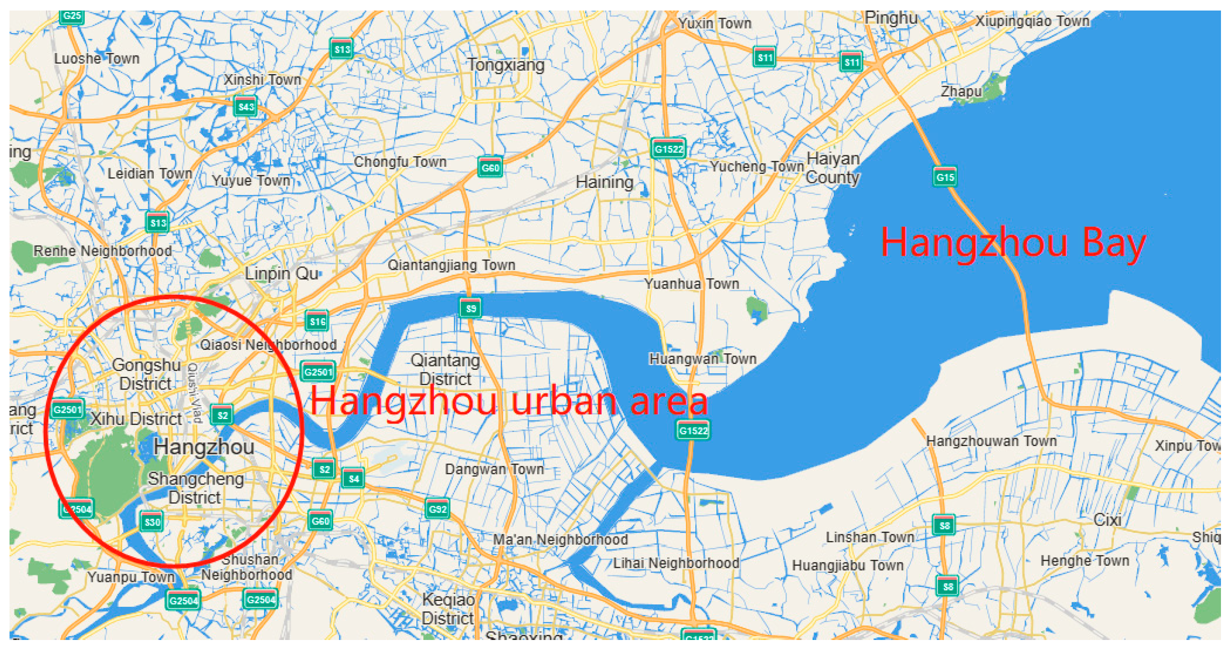
Hangzhou is the capital city of Zhejiang Province, China, and its geographical location is shown in
Figure 1 on both sides of the Qiantang River, near the mouth of Hangzhou Bay. More than 3000 years ago, the urban area of Hangzhou was below sea level, and silt clay with a depth of 10~30 m accumulated in Hangzhou during this period; 1200 years ago, the land in Hangzhou urban area gradually formed, and the area along the river was affected by the alluvium of the Qiantang River, and gradually deposited ranged from 5 to 15 m of sandy silt. As a result, the geological conditions of the alluvial area and the silted area are significantly difference in the main urban area of Hangzhou.
In this paper, a total of 79 cases of excavation cases were collected in Hangzhou, and the grouping and number of cases are shown in
Table 1. A total of 37 cases were in the alluvial area and 42 cases were in the silt area. The excavation in the alluvial area used more bored pile walls as retaining wall, and the proportion of diaphragm wall adopted as retaining wall in the silt area was higher. Early construction referred to excavation cases where the construction time of the excavation was before 2010, and recent construction referred to the cases from 2010 to the present. The scale of cases in the two periods was similar, among which the silted area belonged to the old city of Hangzhou, which was developed earlier and had many early construction cases. The alluvial area was a new urban area, and there have been many recent construction cases.
The average excavation depth of excavations in Hangzhou area was 15.4 m, among which the geological conditions of the alluvial area were better, the average excavation depth was larger, the silty soil area was limited by the geological conditions, and the excavation depth of the excavation was small. The minimum excavation depth of the excavation in the alluvial area was 10.2 m, and the maximum excavation depth was 35.0 m. On the other hand, the minimum excavation depth of the excavation in the silted area was 6.2 m, and the maximum excavation depth was 27.7 m.
Some of the cases collected from the literature lacked geological condition information, and thus the number of geological cases was less than the number of excavation cases.
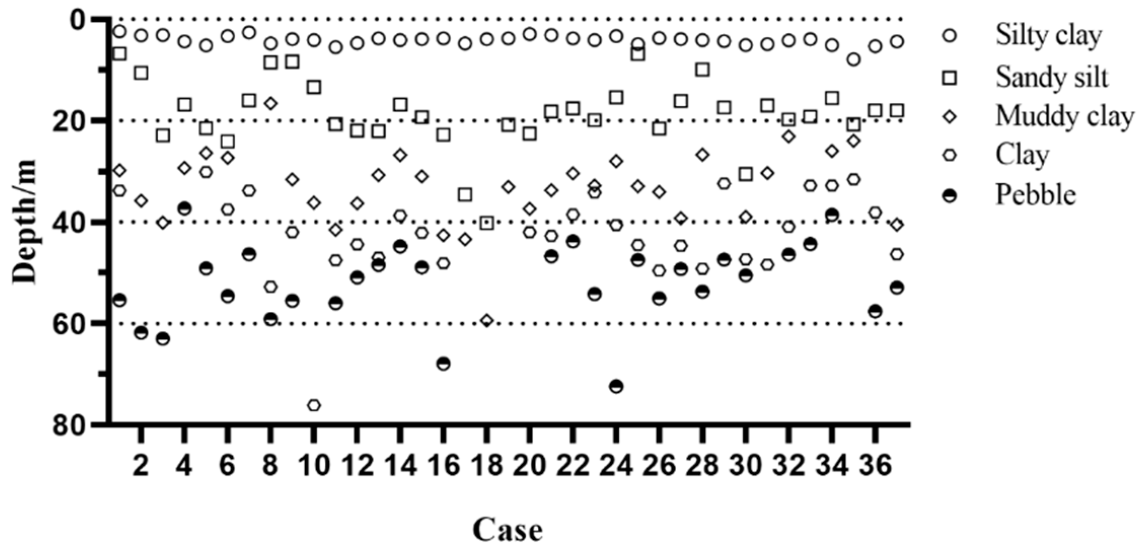
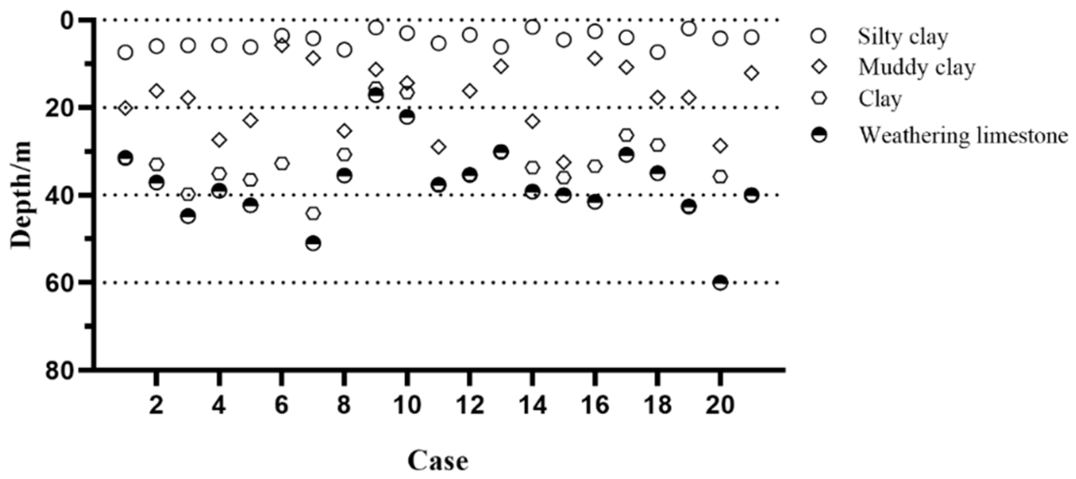
Figure 2 and
Figure 3 show soil stratification of the alluvial area and silt area based on the excavation cases with geological condition information. In order to simplify the analysis, some geological sublayers were merged. There were 37 geological cases in the alluvial area. The thickness of the sandy silt layer generally ranged from 5 to 15 m, there was 10~25 m thick muddy clay and clay under the sandy silt, and about 50 m underground was the pebble or gravel layer. There were only 21 cases with geological condition in the silt area. There was a 5~15 m muddy clay layer 5 m underground, under which was a clay layer ranging from 5 to 15 m with better properties, and generally 40 m underground was the weathered rock layer. The biggest difference between the alluvial area and silty soil area was that the shallow strata did not have a sandy silt layer with relatively good properties.
The average strata thickness of the two areas is shown in
Table 2. The average thickness of the muddy clay or clay layer in the silt area was 29.13 m, the value of the alluvial area was 24.06 m, and the difference between the thickness of two region layers was 21.1%. The shallow strata in the alluvial area were buried with 14.10 m of sandy silt. The geological conditions of the alluvial area were significantly better than those in the silted area. Due to the difference in geological conditions, the integration of excavation case data of the two regions as an overall statistical index of the region would be unrepresentative, so although the urban area of Hangzhou is small, it should still be studied separately when conducting regional excavation deformation statistics.
3. Statistical Analysis
This paper defined the excavation depth of excavations as H, the toe depth of the retaining wall as Ht, the maximum lateral displacement of the retaining wall as δhm, and the maximum ground surface settlement as δvm. The insertion ratio was (Ht − H)/H.
3.1. Movements Affected by Geological Condition
Table 3 shows the difference of statistical analysis method between a single excavation and regional excavations. The single excavation case report focused on the design, construction, and final implementation of an excavation project, as well as the statistical analysis of the deformation curve of the excavation as the project progresses. The statistical analysis of the regional excavations focused on the analysis of deformation characteristic indicators of excavations in the region, focusing on the final wall lateral deformation and surface settlement of excavations, as well as using analysis of the mean, median, and quantile values to study the implementation level and deformation control indicators of the excavation in the region. The mean and median values reflected the average design and construction level of excavations in the region, while the quantile values reflected the deformation distribution of excavations in the region and were helpful in screening out extreme cases and analyzing the causes.
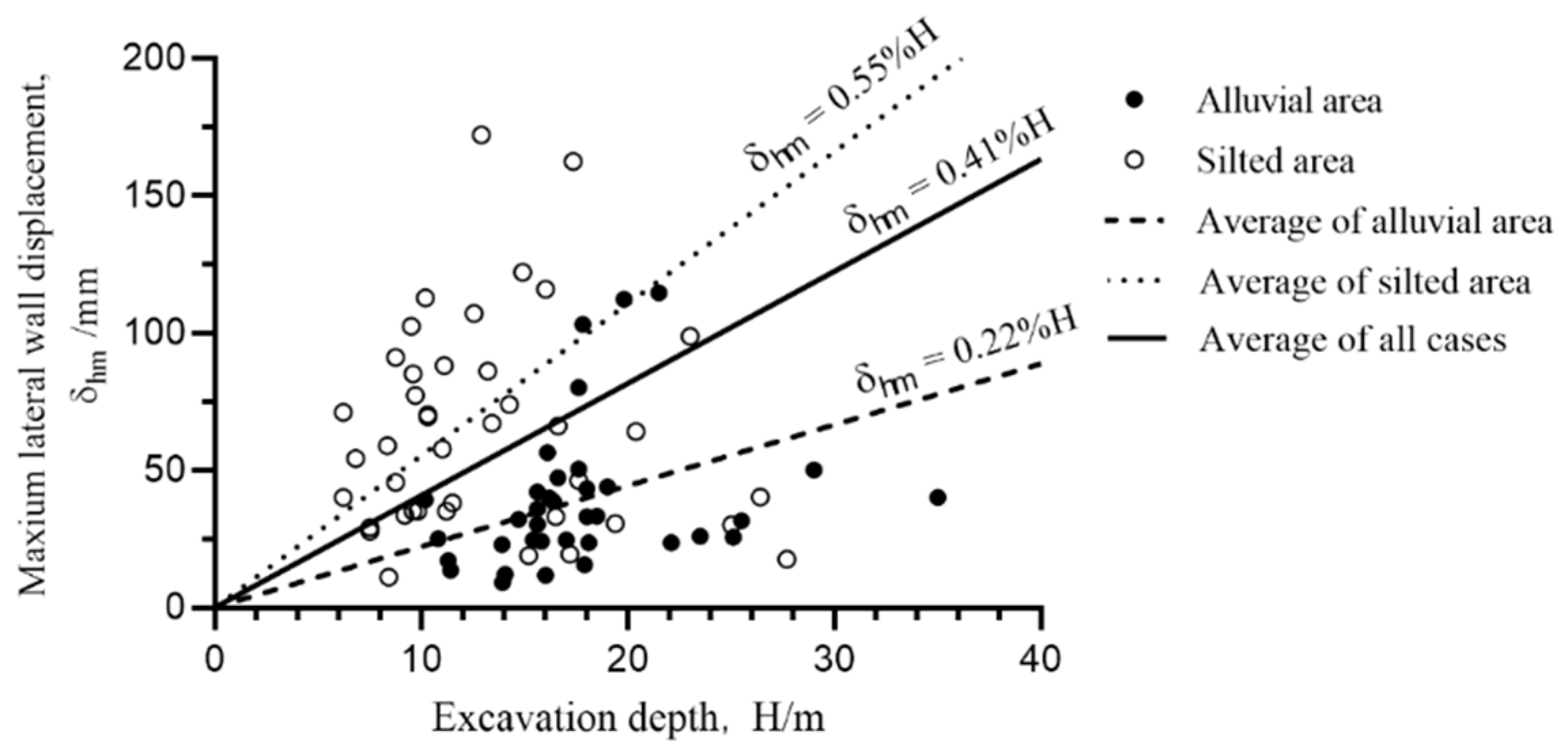
Figure 4 shows the relationship between the maximum lateral wall displacement of the excavation and the excavation depth. It was classified according to the geological area to which the excavation belongs, and an average line was drawn for all excavations, alluvial area excavations, and silt area excavations.
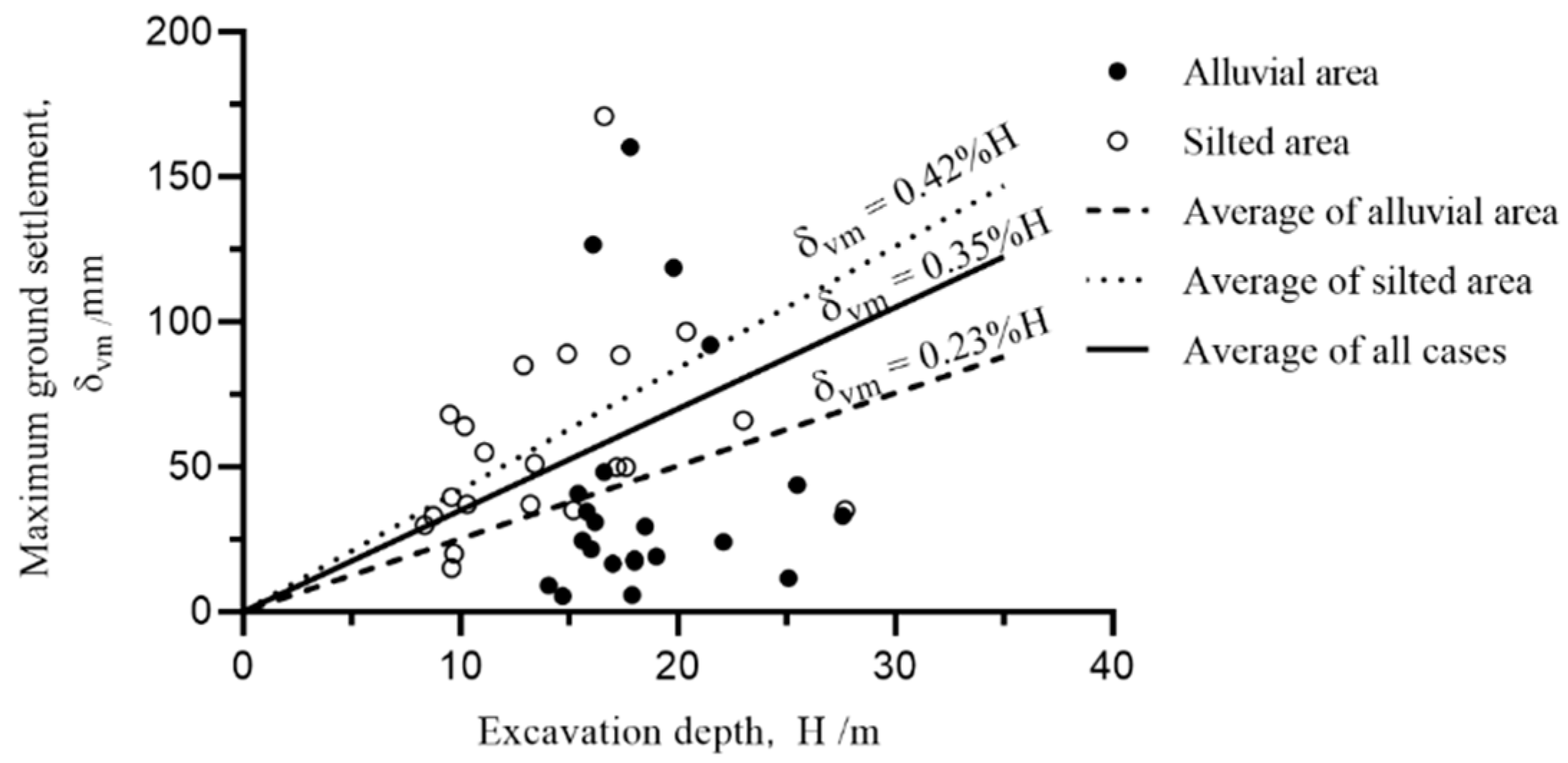
It can be seen from
Figure 4 that the lateral wall displacement of the excavation in the alluvial area was significantly smaller than that in the silted area. And its value was between 0.06%H and 0.58%H, with an average value of 0.22%H. The lateral wall displacement distribution of the excavations in the silt area was more scattered, and its value ranged from 0.06%H to 1.33%H, with an average value of 0.55%H, and the average value of all excavation cases was 0.41%H.
Compared with other deep excavation statistical literatures in the Hangzhou area, the lateral wall displacement values of the 15 excavations in Hangzhou calculated by Liu [
7] were between 0.20%H and 0.90%H, with an average value of 0.50%H, which was close to the lateral wall displacement value of the silted area in this paper. Ding [
9] compiled 37 cases of excavation deformation in the Zhejiang soft soil area and found that the maximum horizontal displacement in Zhejiang area was between 0.04%H and 0.95%H, with an average value of 0.34%H, which was slightly smaller than the value in this paper.
The case data in the alluvial area were concentrated near the mean line, whereas the case data in the silt area were more scattered, indicating that the soft soil in the silt area was more susceptible to disturbance, resulting in poor control of excavation deformation.
Figure 5 is a diagram showing the relationship between ground surface settlement around the excavation and excavation depth. The average surface settlement in the alluvial area was 0.23%H, and its value was between 0.03% and 0.90%. There were four cases that were significantly larger than other cases, and the average value of surface settlement was reduced to 0.14%H when the values of these four cases were removed. The surface settlement in the silted area was distributed in the range of 0.13% to 1.03%, with an average value of 0.42%H, and the average value of surface settlement in the entire Hangzhou area was 0.35%H.
3.2. Movements Affected by Retaining Wall
The dimensionless index δ
hm/H was used to compare the deformation of the retaining wall of different deep excavations.
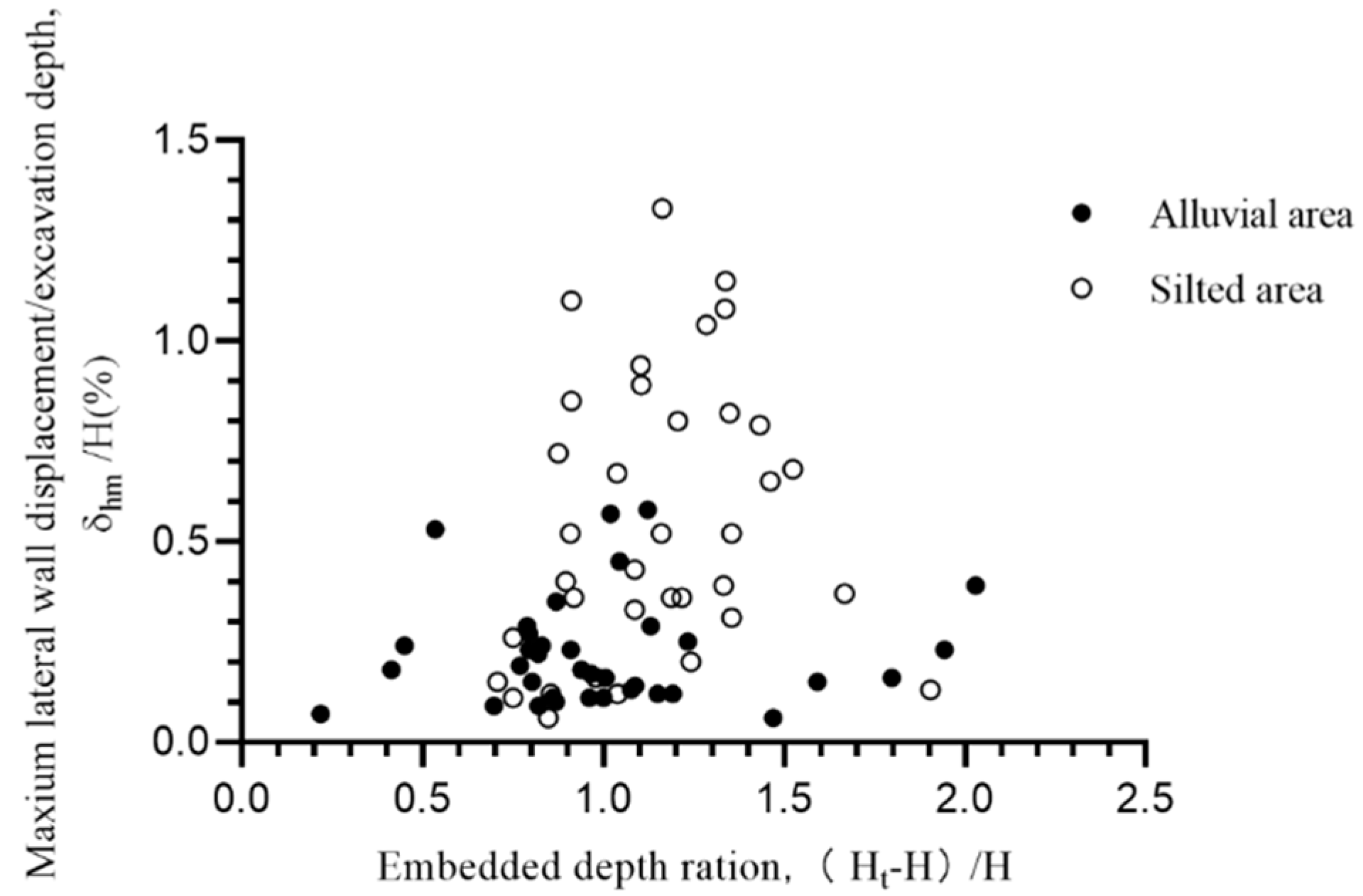
Figure 6 shows the relationship between the insertion ratio of the excavation and the maximum lateral wall displacement. The insertion ratio of the wall in Hangzhou scattered between 0.7 and 1.5, among which the alluvial area ranged from 0.8 to1.3, while the silt area scattered in the 0.9–1.5 range.
The deformation values of the alluvial area were relatively concentrated, and the case values of the silty soil area were more discrete. From the analysis of the case in this paper, most excavations of the alluvial area entered the sandy silt layer strata, and a few entered the deeper silty clay, while the excavation depth of the silted area was mostly in silty clay and deeper clay. The excavation deformation in the silted area was more likely to increase abruptly due to construction factors such as construction disturbance, over-excavation, and delay in the completion of the supporting system, while the sensitivity of the sand layer in the alluvial area was much weaker than that of muddy clay. And the deformation of the excavation in the alluvial area was mainly determined by the geological conditions and the design conditions of the excavation, being less affected by the construction conditions.
Hangzhou has a deep clay layer and abundant groundwater, so the deep excavation support structure basically adopts bored pile walls and diaphragm walls and does not use support types such as soil nails and anchors.
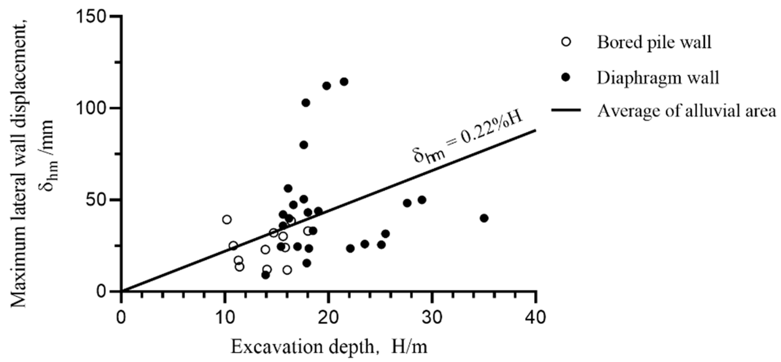
Figure 7 shows the relationship between the maximum lateral wall displacement of the retaining wall of excavations and the excavation depth when the retaining wall was used in different forms in the alluvial area. The excavation depth of the excavation using bored pile walls ranged from 10 to 18 m, and the excavation depth of excavations using diaphragm walls was 15~35 m. The average lateral wall displacement was 0.21%H when using bored pile walls and 0.24%H when using diaphragm walls, which were not significantly different from the average lateral wall displacement of 0.22%H in the alluvial area.
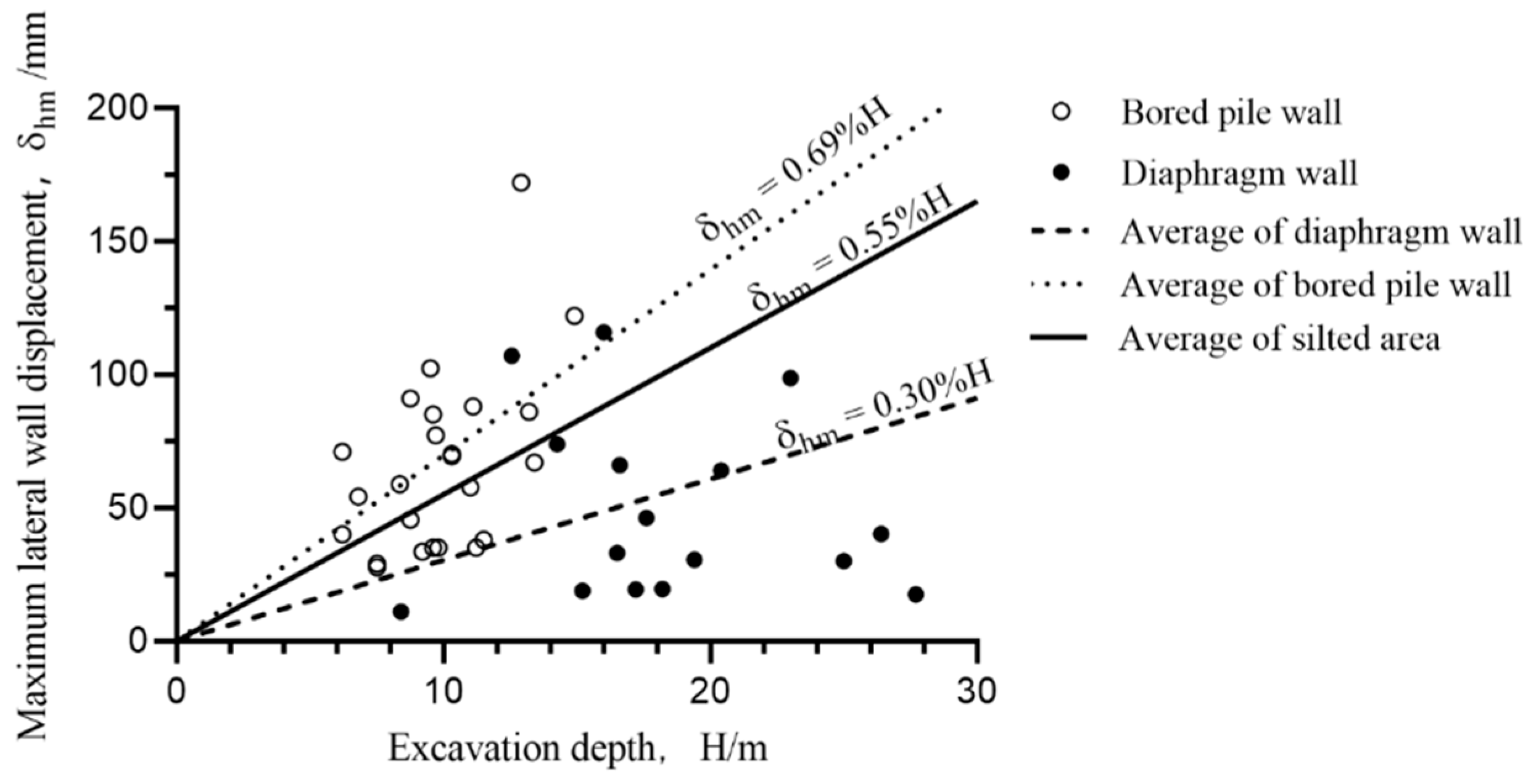
Figure 8 shows the maximum lateral wall displacement diagram of excavations with different wall types in the silt area. The excavation depth of the excavation retaining wall by bored pile walls was between 8 and 15 m, and the diaphragm wall was suitable for the excavation of the silted area with a larger excavation depth, with the general excavation depth being 14~26 m. The average maximum lateral wall displacement of all excavations in the silt area was 0.55%H; the value was 0.30%H for excavations with diaphragm walls as retaining structure and 0.69%H for bored pile walls. It is known from
Figure 8 that the diaphragm wall was used as the excavation retaining structure in the silted area, which had a good effect on the deformation control of the excavation.
Comparing
Figure 7 and
Figure 8, in the alluvial area, using bored pile walls or diaphragm walls as the retaining structure can control the ground movement of the excavation well. In the silty soil area, using diaphragm walls as a retaining structure, which has a better control effect, and diaphragm walls should be used as the retaining structure for the excavation sensitive to environmental deformation.
3.3. Comparison of Influenceing Factors
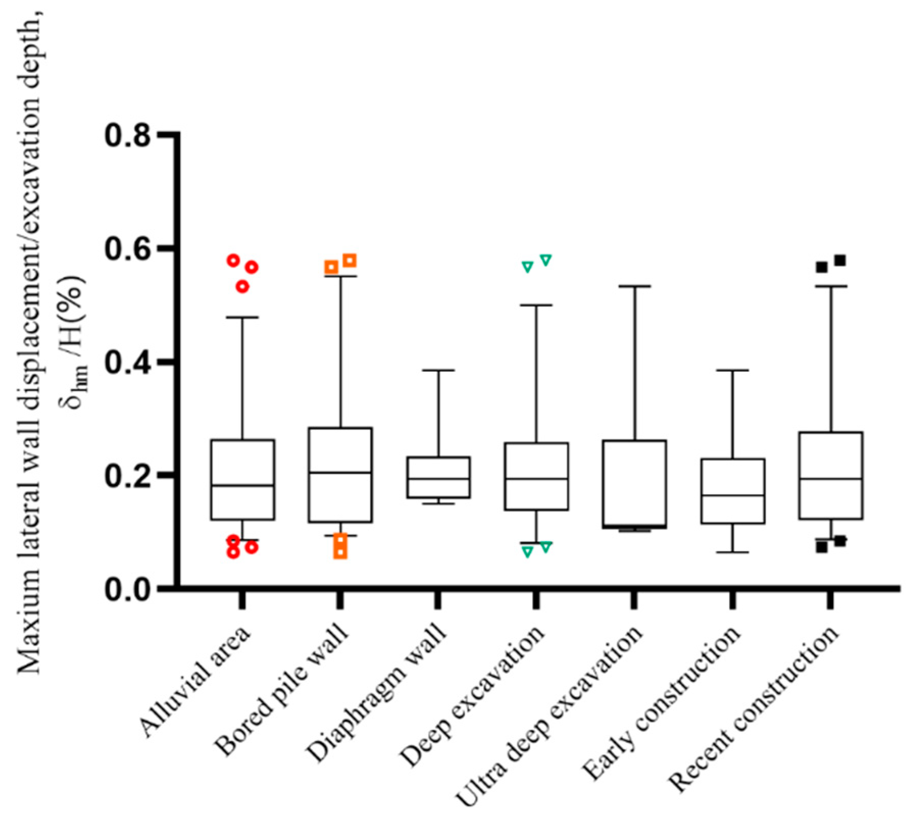
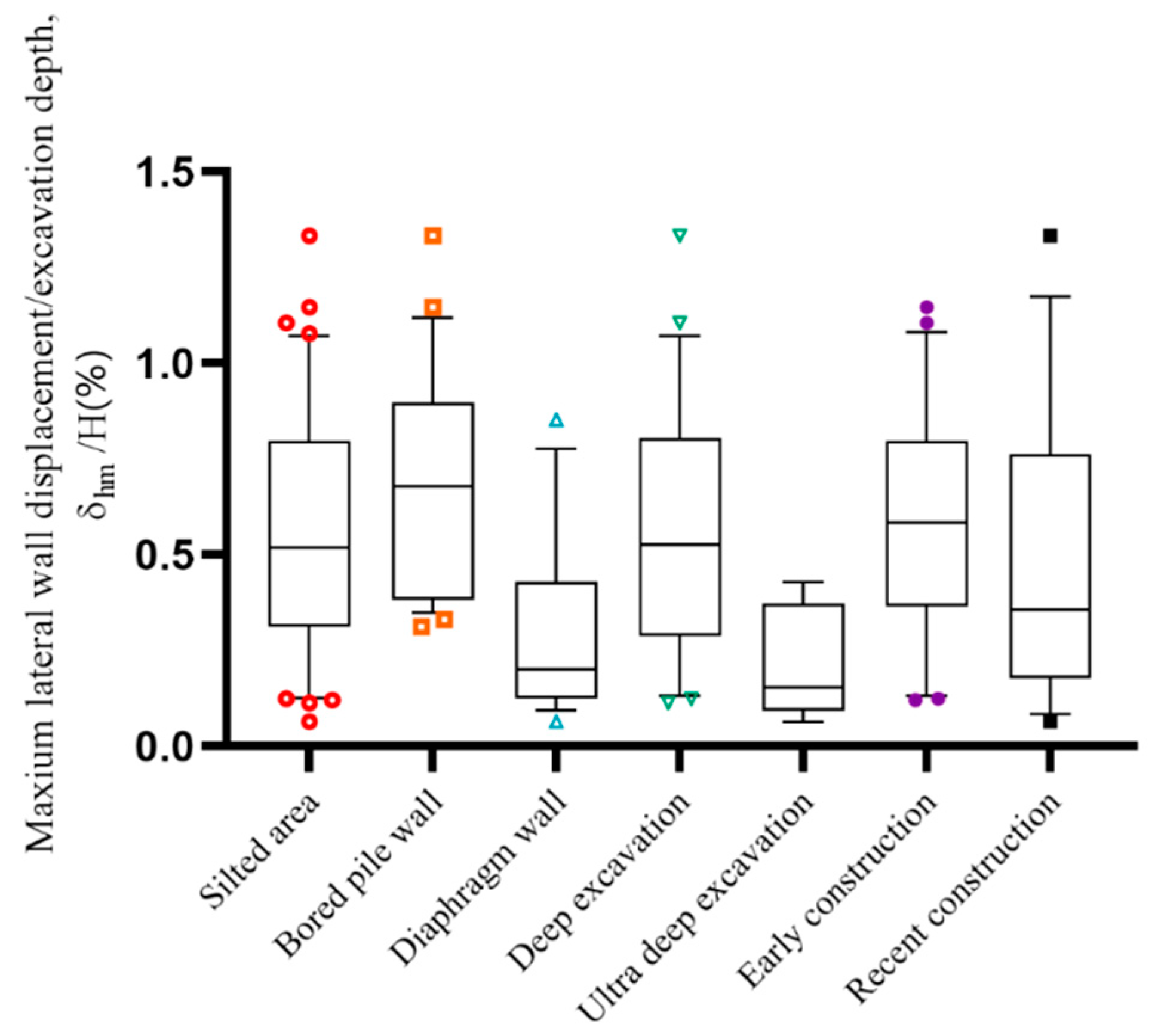
In order to more intuitively compare the impact of various conditions on the environmental effects, we plotted multiple influencing factors in the same figure. As shown in
Figure 9 and
Figure 10, the box plot was used to show the distribution of environmental effects of the excavations, and the curves of the box from top to bottom were 90%, 75%, 50%, 25%, and 10% deformation quantile values. Due to the large number of cases, the case data in the middle box are hidden in the figure. And only the cases of the two extreme deformation intervals of 0~10% and 90~100% are displayed, wherein symbols in
Figure 9 and
Figure 10 represent the deformation values of excavations in the extreme deformation interval. Therefore, there were no specific case data when the group of cases was less than 10. The influencing factors of statistics included the selected retaining wall structure form, excavation depth of excavations, and construction period, among which the deep excavation group refers to the excavations with an excavation depth ranging from 10 to 20 m, and ultra deep excavation refers to excavations with an excavation depth larger than 20 m.
Using the median deformation value of each group as the evaluation index, the median lateral wall displacement value of the excavation in the alluvial area was 0.18%H, and the median deformation value of the excavation in the alluvial area except the ultra-deep excavation group was 0.17~0.22%H. There were six cases in the ultra-deep excavation group, of which four cases’ lateral wall displacement values were around 0.11%, so the 10% quantile, lower ¼, and median values were all at 0.11%H. Among them, the median deformation value of excavation with bored pile walls was 0.19%H, being 0.20%H for the diaphragm wall, 0.20%H for the deep excavation group, 0.11%H for the ultra-deep excavation group, 0.22%H for early construction, and 0.17%H for recent construction. It shows that the deformation of the excavation in the alluvial area of Hangzhou was not sensitive to these factors.
Similarly, taking the median deformation value of each group as the evaluation index, the median deformation value of excavation in the silt area was 0.52%H, and the median deformation value of each group in the silty soil area was distributed in the range of 0.15~0.68%H, which made a significant difference. From
Figure 10, it can be seen that the median lateral wall displacement of the excavations of each group varied greatly. Among them, the median deformation value of excavation using bored pile walls was 0.68%H, being 0.20%H for diaphragm walls, 0.53%H for deep excavation, 0.15%H for ultra-deep excavation, 0.59%H for early construction, and 0.36%H for recent construction. Looking at the 90% quantile value, we found 0.38%H for ultra-deep excavations, 0.77%H for excavations with diaphragm walls, and 1.08~1.19%H for other grouped excavations. It shows that using diaphragm walls as a support structure led to a smaller deformation than other groups. Although in the silted area, the excavation deformation value was larger, the deformation control technique can also effectively reduce the deformation of the excavation.
Compared to the latest excavation deformation examples in Hangzhou that were not in this paper’s database [
15,
16,
17,
18,
19], three of them were in the silty soil area and two were in the alluvial area. The excavation depth in the siltation area case was 28.2 to 34.5 m, and the lateral deformation index ranged between 0.17% and 0.37%H, which was similar to the deformation interval of the ultra-deep excavation group in this paper. The excavation depths of the alluvial area cases were 18.6m and 46.2 m, with deformation indicators δ
hm/H at 0.39% and 0.20%H, respectively. There were also characteristics of a larger excavation depth of excavations, more comprehensive deformation control measures, and a higher level of deformation control.
The geological conditions in Shanghai are similar to the silt area in Hangzhou. The latest regional excavation deformation characteristics analysis paper from Shanghai [
10] counted 664 excavation cases, with a median value of 0.52% for the maximum lateral displacement of the excavation retaining walls. The 25–75% quantile values for the deformation of the excavation retaining wall using bored pile walls were 0.28 and 0.66%H, while the 25–75% quantile values for the excavation deformation using diaphragm walls were 0.20 to 0.40%H, being similar to the quantile values presented in this paper.
The deformation control level of ultra-deep excavations in two areas was the best, indicating that the excavations with large excavation depth were paid high attention; moreover, various deformation control measures were adopted in the design and construction procedure of excavations, which effectively reduced the deformation value of excavations.
4. Discussion
By comparing the statistical average or median value of the dimensionless index to evaluate the deformation control effect of different depth excavations, we found from the previous statistical analysis that the geological differences between the alluvial area and silt area in Hangzhou area will affect the excavation deformation behavior of excavations. The average deformation value of excavation in the alluvial area was 0.22%H, and that in the silted area was 0.55%H, wherein the difference between the two regions was significant. If considering the deformation behavior of two region excavations as one region, it is believed that clustering analysis in urban areas will introduce errors.
The excavation deformation of excavations in an alluvial area is generally small, and it is not easily affected by various factors, with the difference between the average deformation value of each group and the regional value of 0.22%H being small. The mean or median lateral wall deformation values were investigated, and the use of different forms of retaining wall structure or insertion ratio had no significant effect on the deformation of excavations in the alluvial area. The deformation control level of the excavation using diaphragm wall was better overall, while the excavation using the bored pile walls was relatively discrete.
The lateral deformation of excavations in the silty soil area was large, and because the thickness of the muddy clay layer that was susceptible to disturbance was large and the burial depth was shallow, it was more affected by various factors. Compared with bored pile walls, the diaphragm walls had a larger stiffness, which was a better choice for excavation deformation control in a silted area. And the average wall lateral displacement value of excavation using bored pile walls was 0.69%H, with the average deformation value of excavations using a diaphragm wall being 0.30%H. The relationship between the deformation of the excavation in the silty soil area and the insertion ratio of the retaining wall structure was relatively discrete, with the increase in the insertion ratio of the retaining wall structure being not directly related to the improvement of the control ability of the deformation of the excavations. From a design point of view, increasing the insertion ratio is generally in order to embed the walls into the formation with a better holding layer to improve the stability of the excavation.
The statistical characteristics of deformation of excavations in different groups in the silted area were significantly different. The performance of all statistical indicators of the bored pile walls group was poor, indicating that using bored pile as the retaining structure must involve excavations in the silted area that were insensitive to the deformation control. The ultra-deep excavations all used diaphragm walls as the retaining structure, and the deformation control effect of the excavation was better in combination with other engineering measures. The deformation value of the excavation of the recently constructed project was smaller than that of the early construction, indicating that with the development of economic and technical level, the deformation control technology of the excavation had made great progress. Although the geological conditions of the silted area are unfavorable, under the condition of controlling the deformation of the excavation with high standards, the horizontal deformation of the excavation can be effectively reduced by adopting appropriate technology in the design and construction.
In the future study of excavation deformation in Hangzhou, it is necessary to collect excavation case information according to geological zoning grouping and perform well in the collection of design, construction, and excavation deformation information in order to improve the grouping accuracy of subsequent excavation deformation research.
5. Conclusions
In this paper, by collecting the measured data of 79 excavation cases in the Hangzhou area, as well as through statistical processing and analysis, the influence of geological conditions on the horizontal deformation and surface settlement of excavations in the Hangzhou area was studied. The main conclusions are as follows:
- (1)
The geological conditions in Hangzhou can be divided into alluvial area along the river and non-riverside silt area due to different historical causes, with the geological conditions of the alluvial area being better.
- (2)
The average maximum lateral wall displacement of the deep excavations in the Hangzhou area was 0.41%H, the average value of the alluvial area was 0.22%H, and the average value of the silted area was 0.55%H, where H is the excavation depth of excavations.
- (3)
The average maximum surface settlement around excavations in Hangzhou was 0.35%H, the value of the alluvial area was 0.23%H, and the value of the silty soil area was 0.42%H.
- (4)
The deformation of excavations in the alluvial area was less affected by various influencing factors, while excavations in the silted area were more susceptible to influencing factors, such as retaining wall type and excavation depth. And the deformation control of the excavations in the silted area was better supported by diaphragm wall.
- (5)
The difference in geological conditions in Hangzhou leads to significant differences in the deformation behavior of excavations, and the design methods and control indicators of corresponding regions should be discussed according to regional divisions when designing, implementing, and analyzing excavation projects.
Author Contributions
Conceptualization, Y.Z.; methodology, Y.Z.; validation, J.Y. and R.X.; formal analysis, Y.Z. and M.W.; investigation, T.Y.; resources, G.Z. and Q.X.; writing—original draft preparation, Y.Z. and T.Y.; writing—review and editing, J.Y. and R.X.; visualization, M.W.; supervision, R.X.; project administration, R.X.; funding acquisition, R.X. All authors have read and agreed to the published version of the manuscript.
Funding
This research was funded by the National Natural Science Foundation of China (No.41672264).
Institutional Review Board Statement
Not applicable.
Informed Consent Statement
Not applicable.
Data Availability Statement
Publicly available datasets were analyzed in this study. The references are provided in the article.
Conflicts of Interest
The authors declare no conflict of interest.
References
- Peck, R.B. Deep excavations and tunneling in soft ground. In Proceedings of the 7th International Conference of Soil Mechanics and Foundation Engineering, Mexico City, Mexico; 1969; pp. 225–281. Available online: https://www.issmge.org/publications/publication/deep-excavations-and-tunneling-in-soft-ground (accessed on 9 August 2023).
- Clough, G.W.; O’Rourke, T.D. Construction induced movements of insitu walls. In Geotechnical Special Publication: Design and Performance of Earth Retaining Structures; Geotechnical Engineering Division of the American Society of Civil Engineers: Reston, VA USA, 1990; pp. 439–470. [Google Scholar]
- Ou, C.Y.; Hsieh, P.G.; Chiou, D.C. Characteristics of ground surface settlement during excavation. Can. Geotech. J. 1993, 30, 758–767. [Google Scholar] [CrossRef]
- Yoo, C. Behavior of braced and anchored walls in soils overlying rock. J. Geotech. Geoenviron. Eng. 2001, 127, 225–233. [Google Scholar] [CrossRef]
- Long, M. Database for retaining wall and ground movements due to deep excavations. J. Geotech. Geoenviron. Eng. 2001, 127, 203–224. [Google Scholar] [CrossRef]
- Moormann, C. Analysis of wall and ground movements due to deep excavation in soft soils based on a new worldwide database. Soils Found. 2004, 44, 87–98. [Google Scholar] [CrossRef]
- Wang, J.H.; Xu, Z.H.; Wang, W.D. Wall and ground movements due to deep excavations in Shanghai soft soils. J. Geotech. Geoenviron. Eng. 2010, 136, 985–994. [Google Scholar] [CrossRef]
- Wang, J.H.; Xu, Z.H.; Chen, J.J.; Wang, W.D. Deformation Properties of Diaphragm Wall Due to Deep Excavation in Shanghai Soft Soil. Chin. J. Undergr. Space Eng. 2005, 1, 485–489. [Google Scholar]
- Xu, Z.H.; Wang, J.H.; Wang, W.D. Deformation behavior of diaphragm walls in deep excavations in Shanghai. China Civ. Eng. J. 2008, 41, 81–86. [Google Scholar]
- Tan, Y.; Fan, D.D.; Lu, Y. Statistical analyses on a database of deep excavations in Shanghai soft clays in China from 1995–2018. Pract. Period. Struct. Des. Constr. 2021, 27, 04021067. [Google Scholar] [CrossRef]
- Liu, X.W.; Shi, Z.Y.; Yi, D.Q.; Wu, S. Deformation characteristics analysis of braced excavation on soft clay. Chin. J. Geotech. Eng. 1999, 21, 456–460. [Google Scholar]
- Yu, J.; Gong, X.N.; Li, Y.H. Deformation characteristics of deep excavations based on mass data. Chin. J. Geotech. Eng. 2014, 36, 319–324. [Google Scholar]
- Ding, Z.; Wang, D.; Wang, J.Y. Deformation characteristics of Zhejiang soft soil deep excavations and their predictive analysis. Rock Soil Mech. 2015, 36, 507–512. [Google Scholar]
- Ying, H.W.; Yang, Y.W. Characteristics of large and deep soft clay excavation in Hangzhou. Chin. J. Geotech. Eng. 2011, 33, 1838–1846. [Google Scholar]
- Liu, N.W.; Pan, J.J.; Li, M.G.; Li, Y. Deformation characteristics of an ultra-deep and small-scale rectangular excavation in Hangzhou soft clay. Tunn. Undergr. Space Technol. 2023, 137, 105–117. [Google Scholar] [CrossRef]
- Ying, H.W.; Cheng, K.; Liu, S. An efficient method for evaluating the ground surface settlement of Hangzhou metro deep basement considering the excavation process. Acta Geotech. 2022, 17, 5759–5771. [Google Scholar] [CrossRef]
- Mei, Y.; Wang, L.; Zhou, D.B.; Fu, L. Displacement Characteristics of a Deep Excavation in Hangzhou Soft Clay. Adv. Civ. Eng. 2022, 2022, 5469471. [Google Scholar] [CrossRef]
- Chen, D.; Yang, X.L.; Liu, X.Y.; Li, Y.; Liu, X.W.; Xie, X.R.; Chen, J. Reverse construction method design of landside traffic center foundation pit of Ⅲ project of Hangzhou Xiaoshan International Airport. Build. Struct. 2022, 52, 130–135. [Google Scholar]
- Wei, G.; Feng, F.F.; Zhu, J.X.; Li, J.; Zhang, X.J.; Chen, C.L. Measurement and analysis of deep foundation pit excavation of adjacent shield tunnel with servo steel support. J. Nat. Disasters 2023, 32, 130–135. [Google Scholar] [CrossRef]
| Disclaimer/Publisher’s Note: The statements, opinions and data contained in all publications are solely those of the individual author(s) and contributor(s) and not of MDPI and/or the editor(s). MDPI and/or the editor(s) disclaim responsibility for any injury to people or property resulting from any ideas, methods, instructions or products referred to in the content. |
© 2023 by the authors. Licensee MDPI, Basel, Switzerland. This article is an open access article distributed under the terms and conditions of the Creative Commons Attribution (CC BY) license (https://creativecommons.org/licenses/by/4.0/).


 ,
, 


