


Geological Uniqueness and Potential Geotouristic Appeal of Murge and Premurge, the First Territory in Puglia (Southern Italy) Aspiring to Become a UNESCO Global Geopark
 , , , , , , , , , and
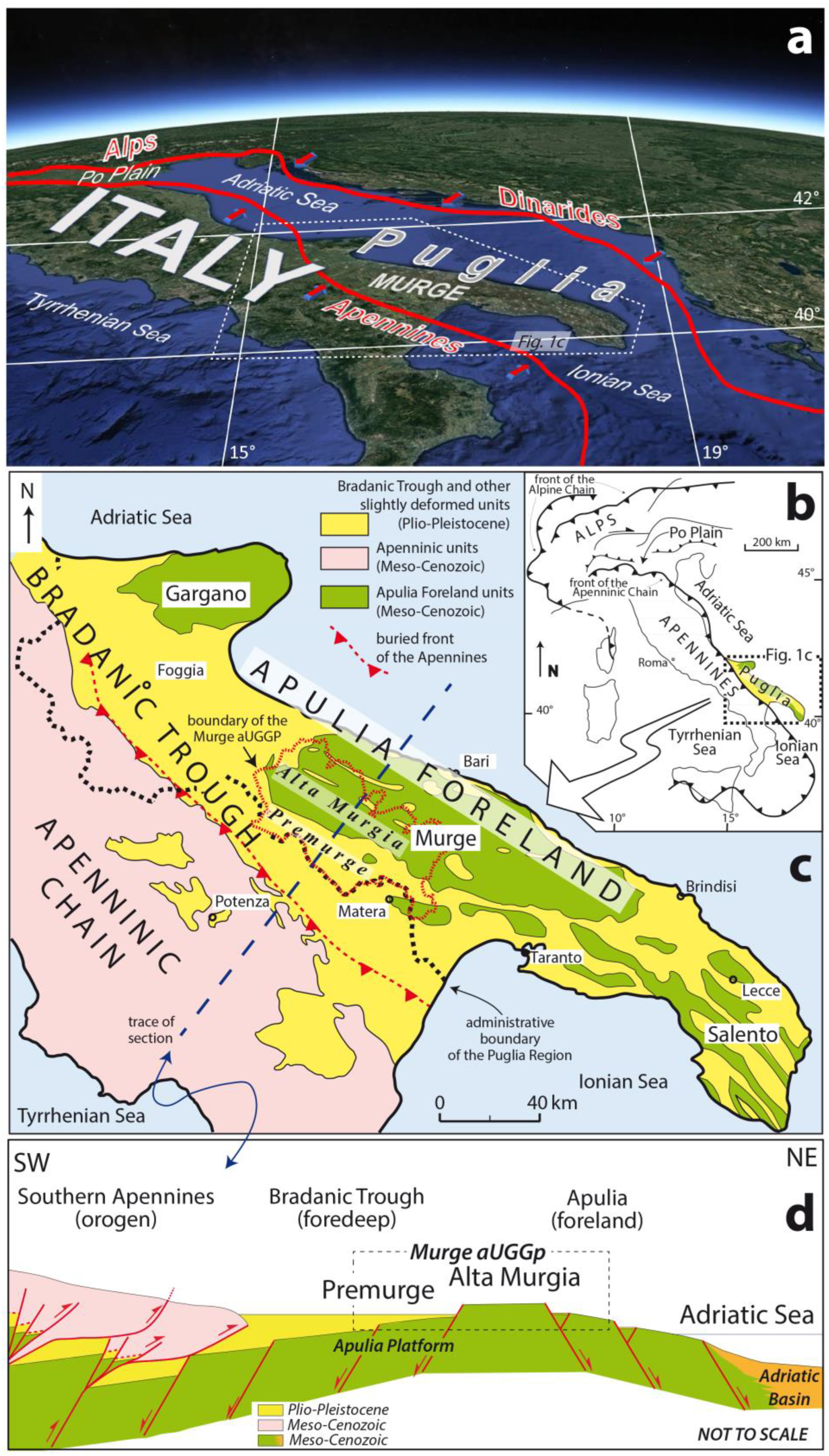
Abstract
:1. Introduction
2. Preliminary Geographic Information
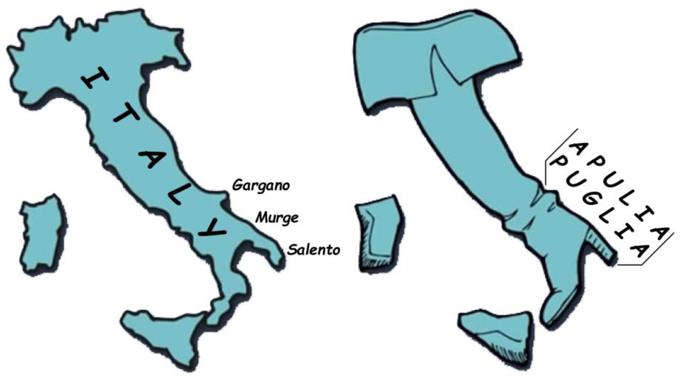
2.1. Puglia/Apulia
2.2. Murge/Murgia
2.3. The Proposed Geopark Name
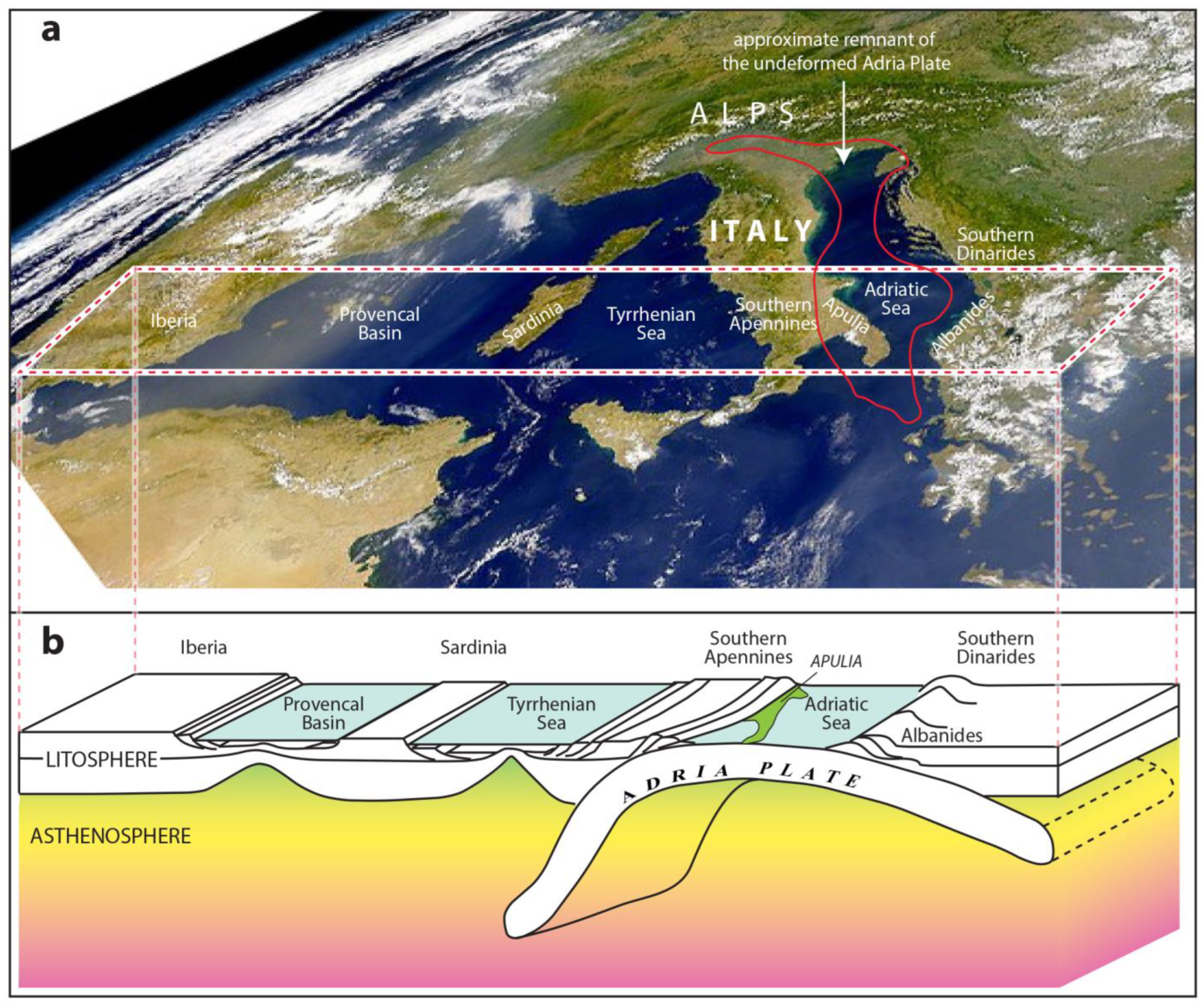
3. Geological Evolution of Apulia: The Leitmotiv of the Murge aUGGp


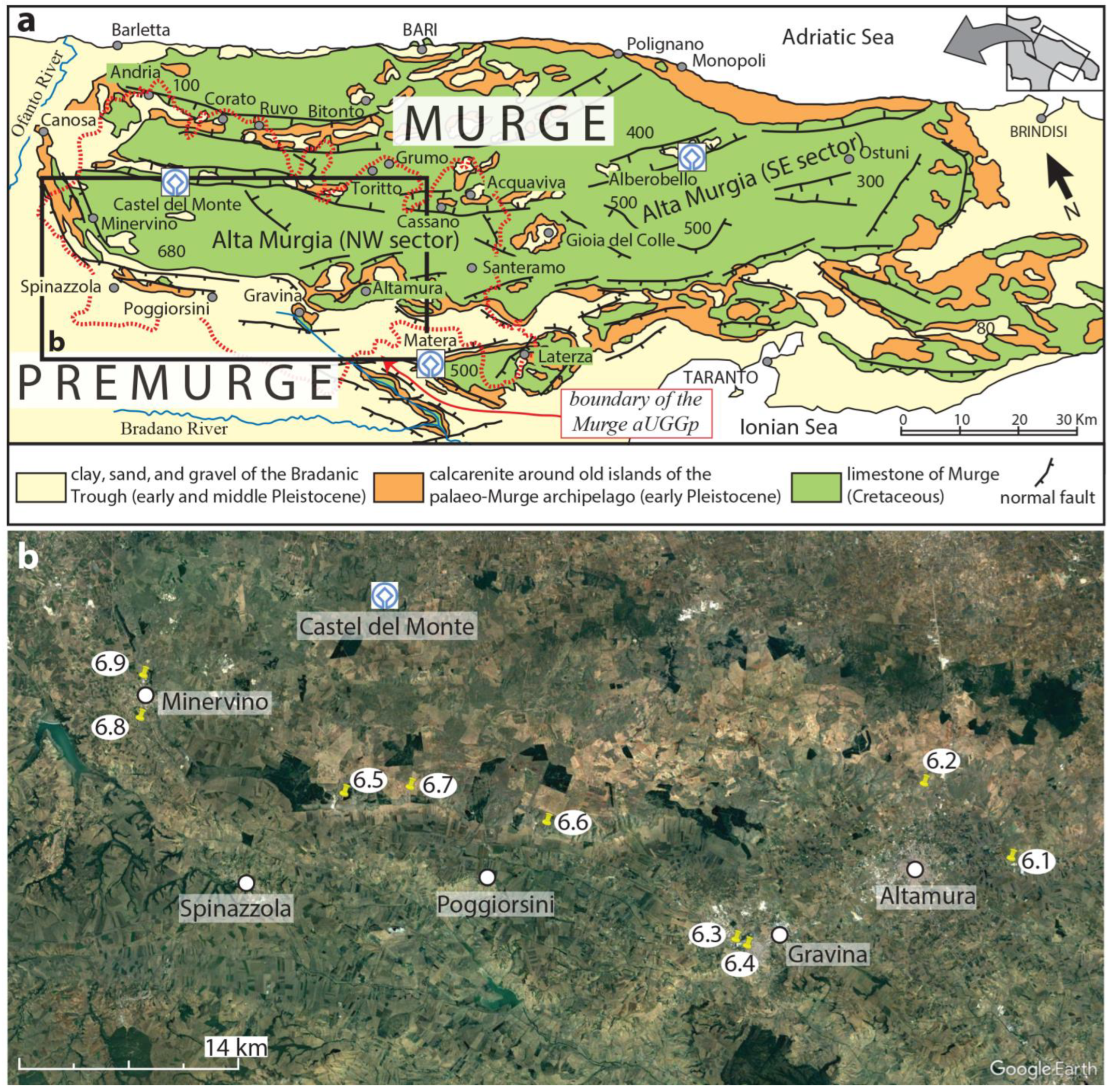
4. Main Geological Features of the Murge aUGGp
5. The Geotouristic Appeal of the Murge aUGGp
- -
- -
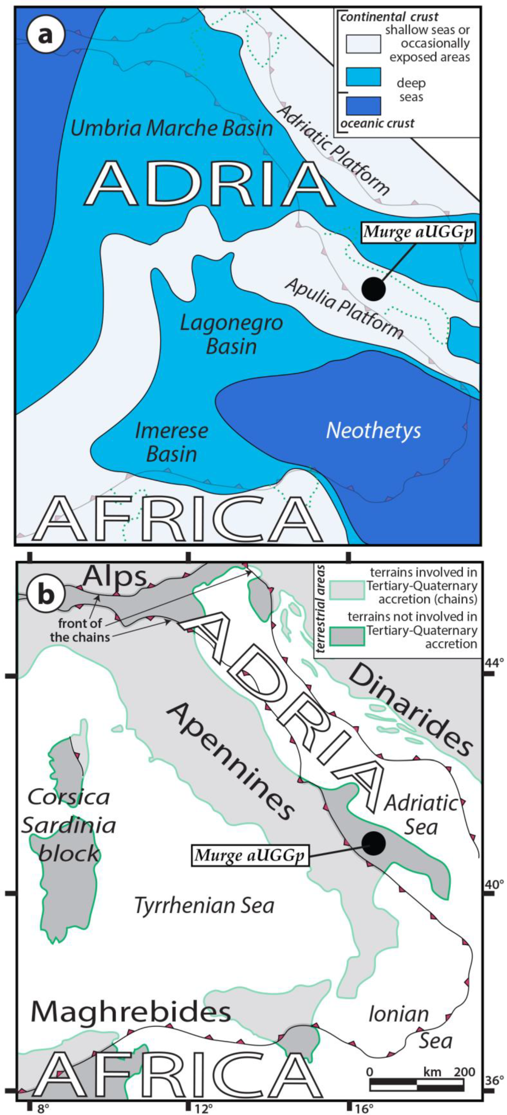
- The crust of Adria is still rooted to its mantle, as suggested by the analysis of several seismic lines crossing Apulia ([60] and quoted references), and the Cretaceous evolution of the plate is spectacularly recorded in the Murge area due to the outcropping shallow-water carbonate succession of one of the biggest peri-Adriatic carbonate platforms (the Apulia Carbonate Platform) [32].
- -
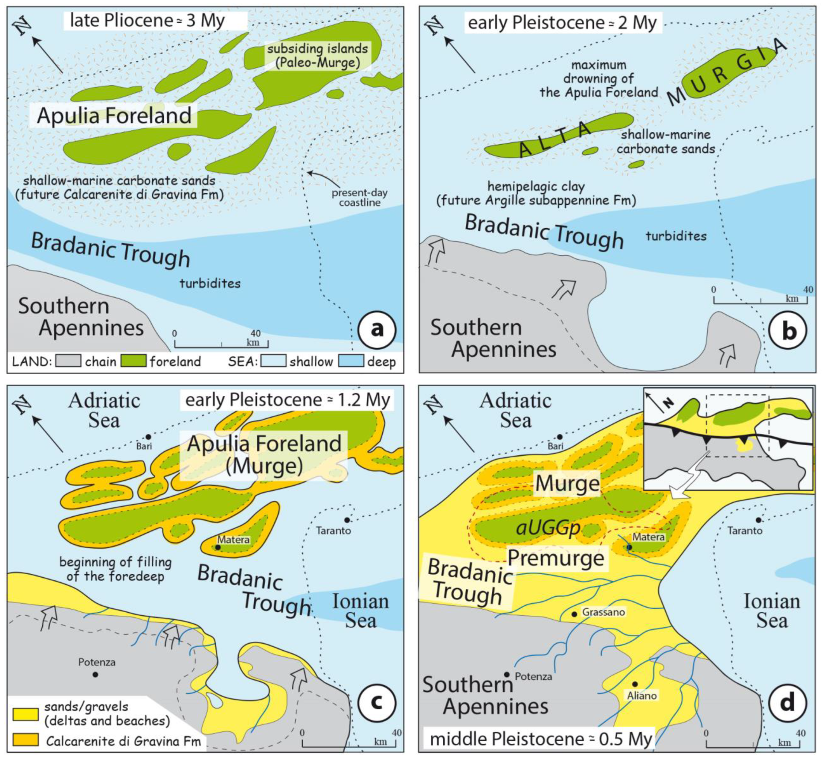
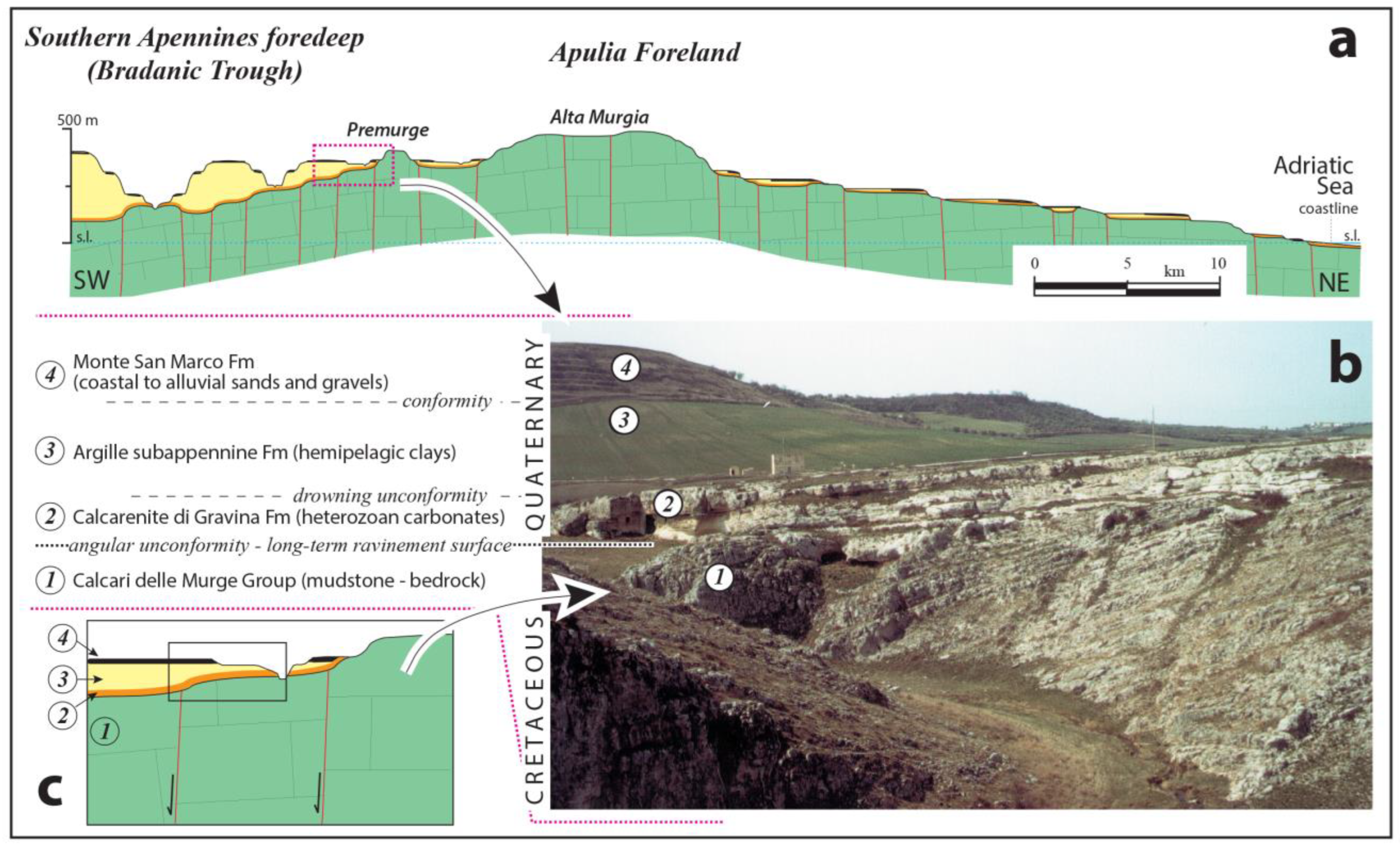
- An “anomalous” regional middle-late Quaternary foreland uplift led to spectacular exposition from the bedrock of a complete foredeep succession, pointing out that the latter can commonly be observed only after being deformed and involved in the mountain chain or visualized from subsurface data (i.e., seismic lines), especially in marine settings [42,43,54,93].
6. Some Examples of Geosites of the Murge aUGGp
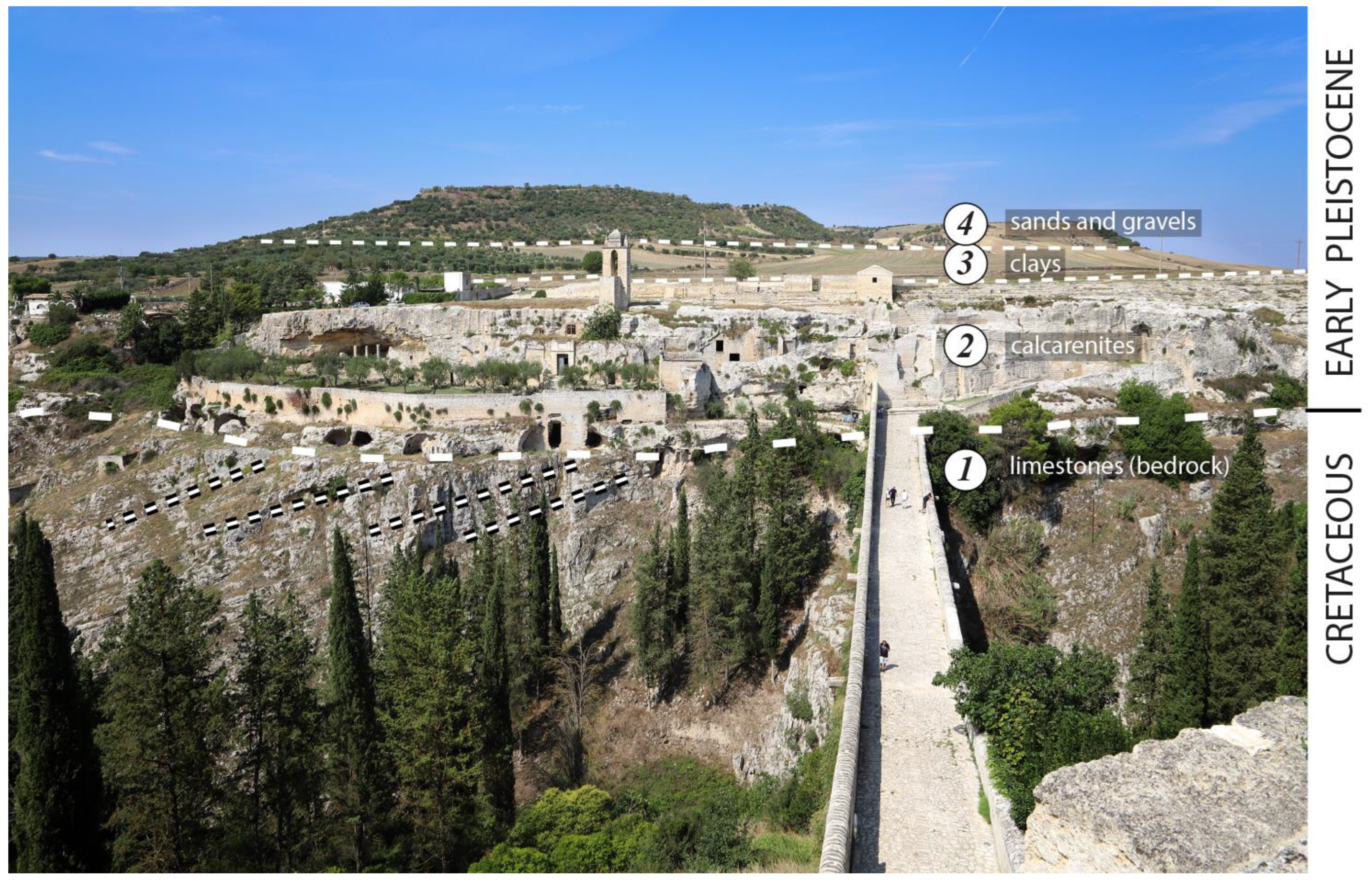
6.1. Apulia Carbonate Platform Geosites: The Disused Quarry “Cava Pontrelli” of Altamura
- (a)
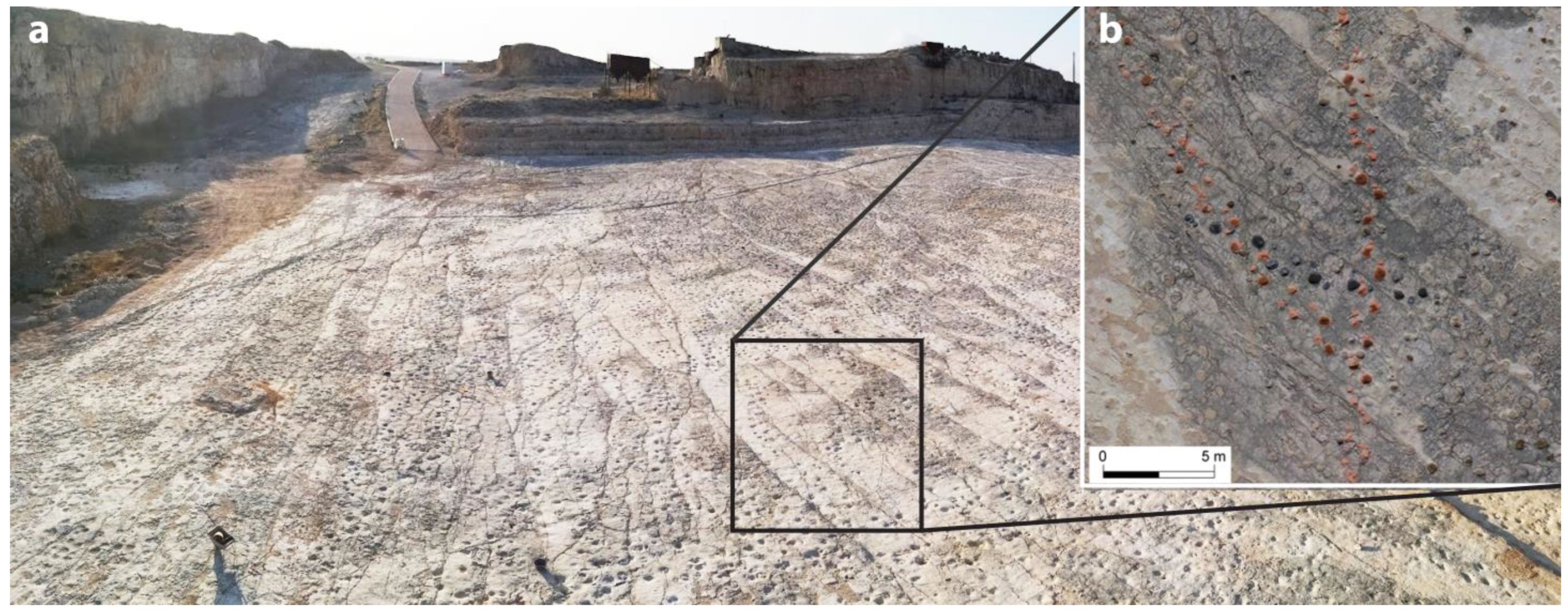
- The dinosaur tracksite
- (b)
- Orbitally-controlled shallowing-upward peritidal sequences
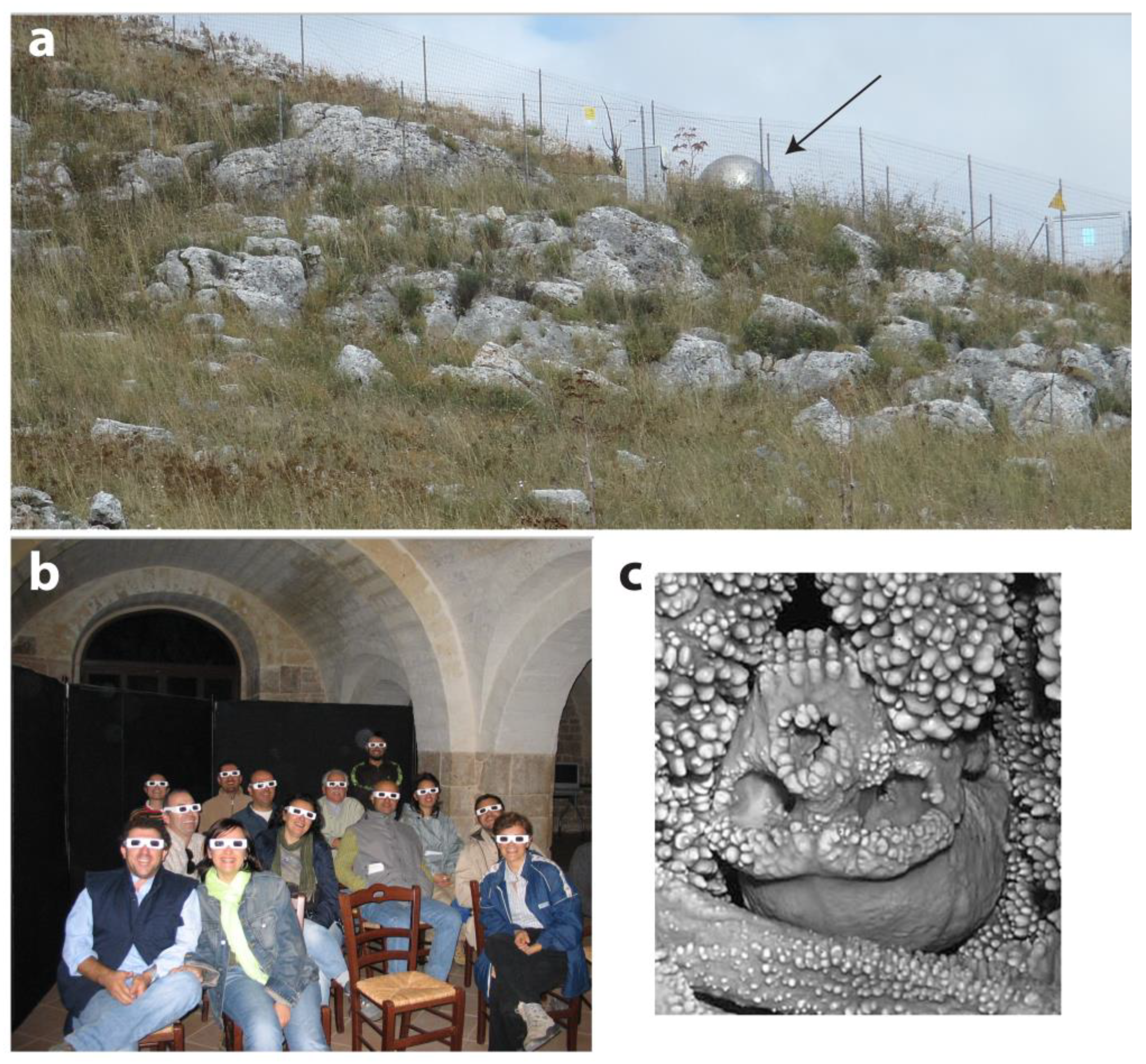
6.2. Karst Geosites/Man and Geology Geosites: The “Grotta di Lamalunga” (Lamalunga Cave), in the Vicinity of Altamura
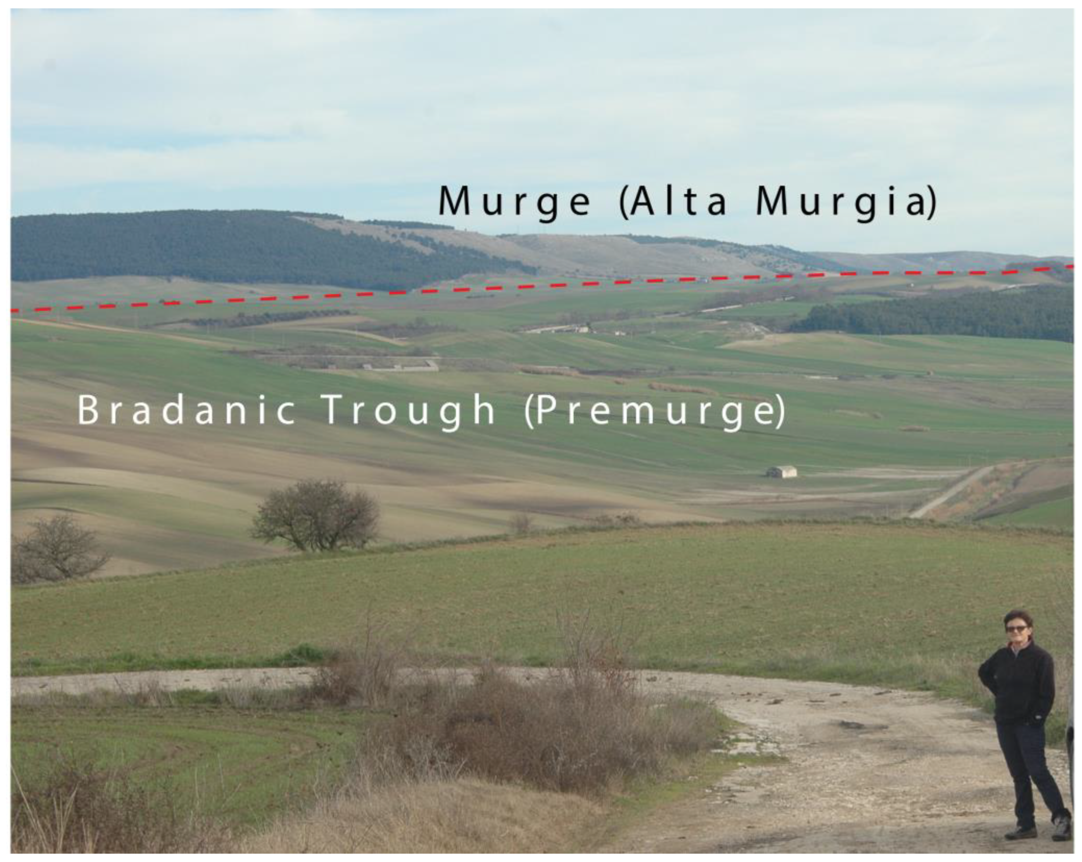
6.3. Spatial and/or Panoramic Geosites/Bradanic Trough Geosites/Quaternary Uplift-Related Geosites: The Panoramic Point of Gravina in Puglia
6.4. Hydrogeology- and Water-Related Geosites: The Sant’Angelo—Fontana della Stella Aqueduct, an Example of Tapping and Distributing Water since Middle Age
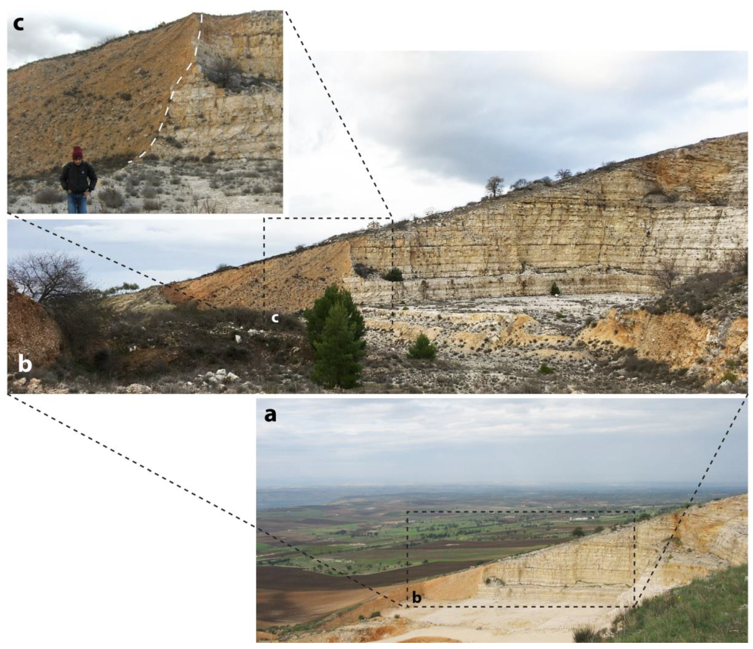
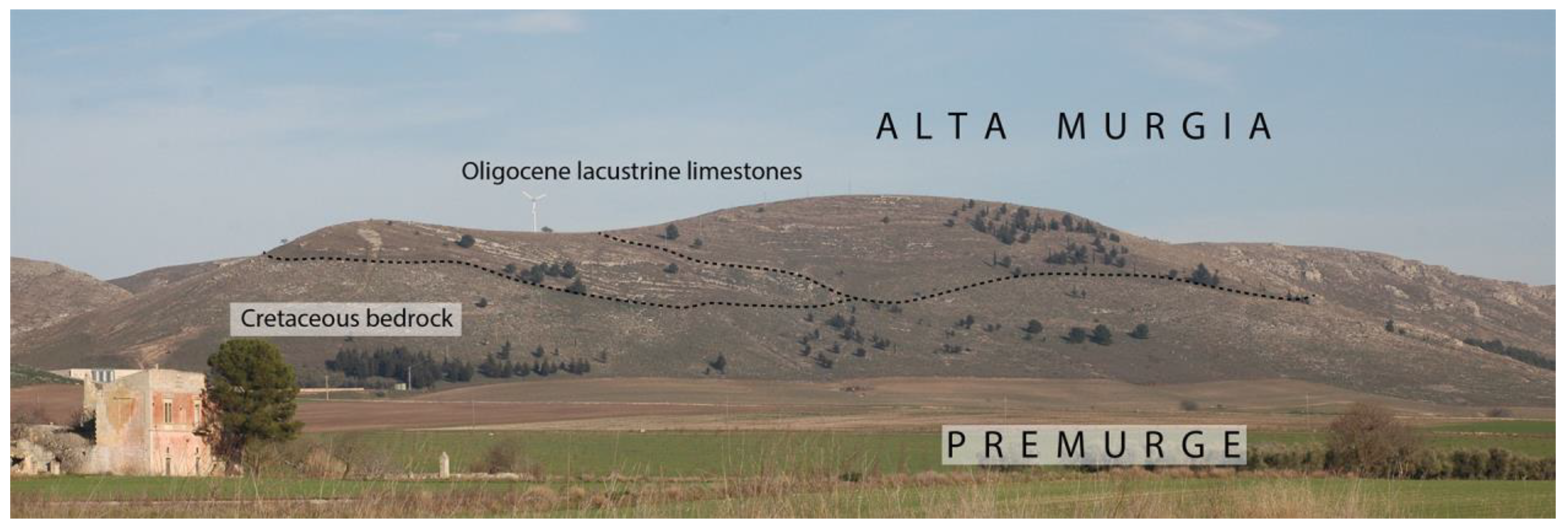
6.5. Spatial and/or Panoramic Geosites/Tectonics-Related Geosites: The Alta Murgia (or Murge Alte) Scarp
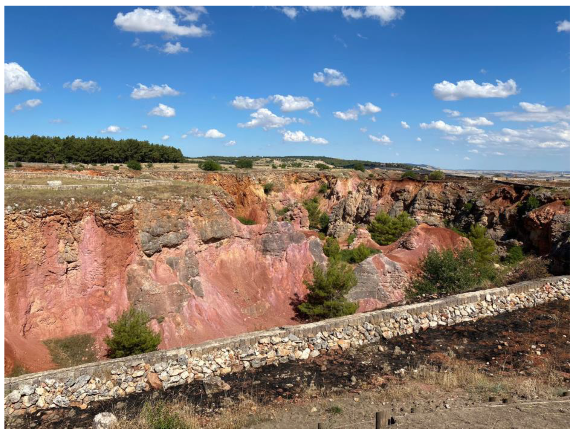
6.6. Apulia Carbonate Platform Geosites/Tectonics-Related Geosites: The Oligocene Calcare a Planorbis Formation
6.7. Apulia Carbonate Platform Geosites/Tectonics-Related Geosites: The intra-Cretaceous Unconformity
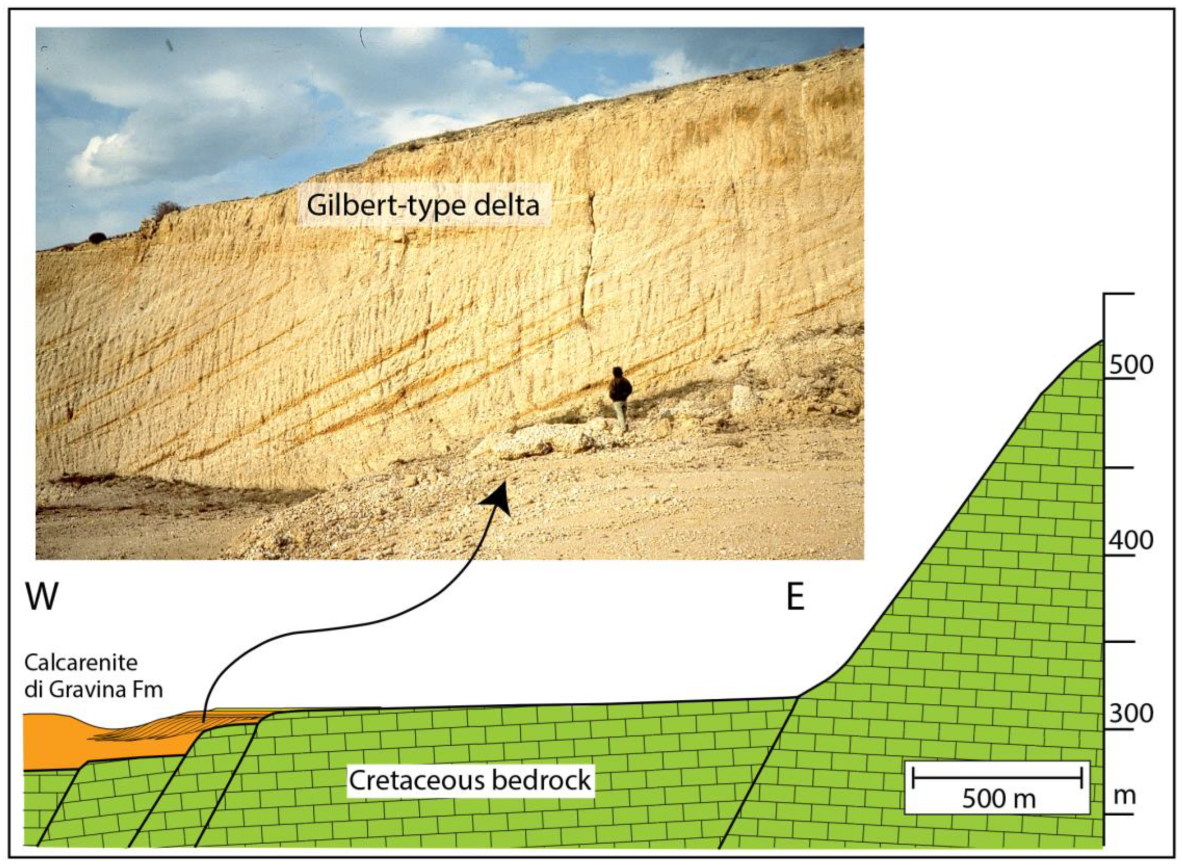
6.8. Bradanic Trough Geosites: A Gilbert-Type Delta in Carbonate Succession
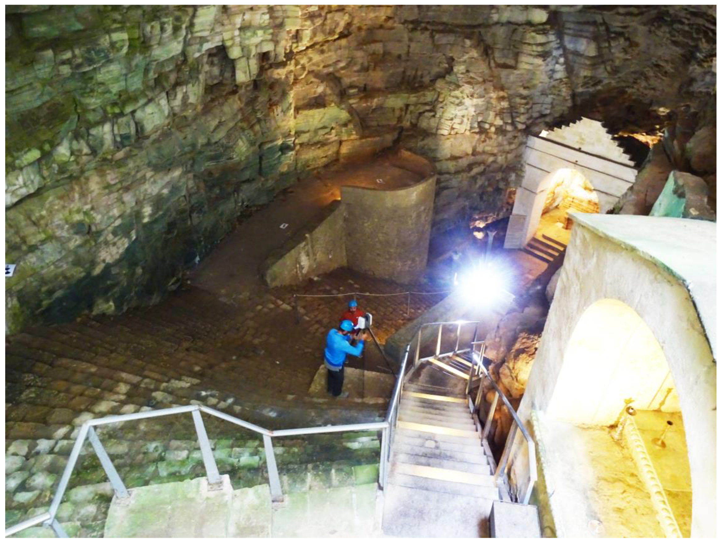
6.9. Karst Geosites/Man and Geology Geosites: The “Grotta di San Michele” (San Michele Cave) at Minervino
7. Conclusions
8. A General Remark
Author Contributions
Funding
Institutional Review Board Statement
Informed Consent Statement
Data Availability Statement
Acknowledgments
Conflicts of Interest
References
- Fiore, A.; Valletta, S. Il Patrimonio Geologico Della Puglia. Territorio e Geositi; Fiore, A., Valletta, S., Eds.; SIGEA: Avigliana, Italy, 2010. [Google Scholar]
- Bentivenga, M.; Geremia, F.; Fiore, A.; Valletta, S. Geoheritage: Protecting and Sharing. In Proceedings of the 7th Int. Symp. ProGEO on the Conservation of the Geological Heritage “Geoheritage: Protecting and Sharing”, Bari, Italy, 24–28 September 2012. [Google Scholar]
- Mastronuzzi, G.; Valletta, S.; Damiani, A.; Fiore, A.; Francescangeli, R.; Giandonato, P.B.; Iurilli, V.; Sabato, L. Geositi Della Puglia. Ricognizione e Verifica Dei Geositi e Delle Emergenze Geologiche Della Regione Puglia; Mastronuzzi, G., Valletta, S., Damiani, A., Fiore, A., Francescangeli, R., Giandonato, P.B., Iurilli, V., Sabato, L., Eds.; Graphic Concept Lab.: Bari, Italy, 2015. [Google Scholar]
- Doglioni, C. Foredeeps versus Subduction Zones. Geology 1994, 22, 271. [Google Scholar] [CrossRef]
- Sabato, L.; Tropeano, M.; Festa, V.; Longhitano, S.G.; Dell’Olio, M. Following Writings and Paintings by Carlo Levi to Promote Geology within the “Matera-Basilicata 2019, European Capital of Culture” Events (Matera, Grassano, Aliano—Southern Italy). Geoheritage 2019, 11, 329–346. [Google Scholar] [CrossRef]
- Ghielmi, M.; Tropeano, M.; Carubelli, P.; Pugliese, A.; Sabato, L. Evoluzione Tettono-Stratigrafica Nel Pliocene e Quaternario, Con Particolare Riferimento All’avanfossa Appenninica. In Basilicata; Tropeano, M., Sabato, L., Schiattarella, M., Eds.; Società Geologica Italiana: Bologna, Italy, 2020; pp. 51–61. [Google Scholar]
- Zackabier. Europe According to Creative People—What Europe’s Countries Look Like. Available online: https://www.youtube.com/watch?v=2L-ZYcqqGds (accessed on 15 March 2023).
- Wilson, J.T. Hypothesis of Earth’s Behaviour. Nature 1963, 198, 925–929. [Google Scholar] [CrossRef]
- Dewey, J.F.; Horsfield, B. Plate Tectonics, Orogeny and Continental Growth. Nature 1970, 225, 521–525. [Google Scholar] [CrossRef]
- Dewey, J.F.; Bird, J.M. Mountain Belts and the New Global Tectonics. J. Geophys. Res. 1970, 75, 2625–2647. [Google Scholar] [CrossRef]
- Cuffaro, M.; Riguzzi, F.; Scrocca, D.; Antonioli, F.; Carminati, E.; Livani, M.; Doglioni, C. On the Geodynamics of the Northern Adriatic Plate. Rend. Lincei 2010, 21, 253–279. [Google Scholar] [CrossRef]
- Carminati, E.; Petricca, P.; Doglioni, C. Mediterranean Tectonics. In Encyclopedia of Geology (Second Edition); Alderton, D., Scott, A.E., Eds.; Academic Press: Cambridge, MA, USA, 2021; Volume 4, pp. 408–419. [Google Scholar]
- Benioff, H. Orogenesis and Deep Crustal Structure—Additional Evidence from Seismology. Bull. Geol. Soc. Am. 1954, 65, 385–400. [Google Scholar] [CrossRef]
- White, D.A.; Roeder, D.H.; Nelson, T.H.; Crowell, J.C. Subduction. Geol. Soc. Am. Bull. 1970, 81, 3431–3432. [Google Scholar] [CrossRef]
- Suess, E. Das Antlitz Der Erde (The Face of the Earth); F. Tempsky: Prague, Czech Republic, 1883. [Google Scholar]
- Argand, É. La Tectonique de l’Asie. In Proceedings of the Proceedings of the XIIIth International Geological Congress, Brussels, Belgium, 10 August 1924; pp. 171–372. [Google Scholar]
- Channell, J.; D’Argenio, B.; Horvath, F. Adria, the African Promontory, in Mesozoic Mediterranean Palaeogeography. Earth Sci. Rev. 1979, 15, 213–292. [Google Scholar] [CrossRef]
- Pieri, P.; Festa, V.; Moretti, M.; Tropeano, M. Quaternary Tectonic Activity of the Murge Area Apulian Foreland—Southern Italy. Ann. Geofis. 1997, 40, 1395–1404. [Google Scholar] [CrossRef]
- Tropeano, M.; Pieri, P.; Moretti, M.; Festa, V.; Calcagnile, G.; Del Gaudio, V.; Pierri, P. Tettonica Quaternaria Ed Elementi Di Sismotettonica Nell’area Delle Murge (Avampaese Apulo). Il Quat. 1997, 10, 543–548. [Google Scholar]
- Dewey, J.F.; Pitman, W.C.; Ryan, W.B.F.; Bonnin, J. Plate Tectonics and the Evolution of the Alpine System. Geol. Soc. Am. Bull. 1973, 84, 3137–3180. [Google Scholar] [CrossRef]
- Van Hinsbergen, D.J.J.; Torsvik, T.H.; Schmid, S.M.; Maţenco, L.C.; Maffione, M.; Vissers, R.L.M.; Gürer, D.; Spakman, W. Orogenic Architecture of the Mediterranean Region and Kinematic Reconstruction of Its Tectonic Evolution since the Triassic. Gondwana Res. 2020, 81, 79–229. [Google Scholar] [CrossRef]
- Lort, J.M. The Tectonics of the Eastern Mediterranean: A Geophysical Review. Rev. Geophys. 1971, 9, 189–216. [Google Scholar] [CrossRef]
- Stampfli, G.M.; Mosar, J. The Making and Becoming of Apulia. Mem. Sci. Geol. 1999, 51, 141–154. [Google Scholar]
- Stampfli, G.M. Plate Tectonics of the Apulia-Adria Microcontinents. In CROP PROJECT: Deep Seismic Exploration of the Central Mediterranean and Italy; Finetti, I.R., Ed.; Elsevier: Amsterdam, The Netherlands, 2005; pp. 747–766. ISBN 9780080457604. [Google Scholar]
- Bernoulli, D.; Jenkyns, H.C. Alpine, Mediterranean, and Central Atlantic Mesozoic Facies in Relation to the Early Evolution of the Tethys. In Modern and Ancient Geosynclinal Sedimentation; Sp. Publ. 19; Dott, R.H., Shaver, R.H., Eds.; SEPM (Society of Economic Paleontologists and Mineralogists): Tulsa, OK, USA, 1974; pp. 129–160. [Google Scholar]
- Stampfli, G.M.; Hochard, C. Plate Tectonics of the Alpine Realm. Geol. Soc. Lond. Spec. Publ. 2009, 327, 89–111. [Google Scholar] [CrossRef]
- Catalano, R. Appunti Di Geologia Regionale. Available online: http://www.siripro.it/dipgeopa.asp?structure=education&where=regionale&cap=09&subc=5&lang=it (accessed on 15 March 2023).
- Doglioni, C.; Moretti, I.; Roure, F. Basal Lithospheric Detachment, Eastward Mantle Flow and Mediterranean Geodynamics: A Discussion. J. Geodyn. 1991, 13, 47–65. [Google Scholar] [CrossRef]
- Ricchetti, G.; Ciaranfi, N.; Luperto Sinni, E.; Mongelli, F.; Pieri, P. Geodinamica Ed Evoluzione Sedimentaria e Tettonica Dell’avampaese Apulo. Mem. Soc. Geol. Ital. 1988, 41, 57–82. [Google Scholar]
- Bernoulli, D. Mesozoic-Tertiary Carbonate Platforms, Slopes and Basins of the External Apennines and Sicily. In Anatomy of an Orogen: The Apennines and Adjacent Mediterranean Basins; Springer: Dordrecht, The Netherlands, 2001; pp. 307–325. [Google Scholar]
- Mostardini, F.; Merlini, S. Appennino Centro Meridionale. Sezioni Geologiche e Proposta Di Modello Strutturale. Boll. Soc. Geol. Ital. 1986, 7, 117–202. [Google Scholar]
- Zappaterra, E. Carbonate Paleogeographic Sequences of the Periadriatic Region. Boll. Soc. Geol. Ital. 1990, 109, 5–20. [Google Scholar]
- Zappaterra, E. Source-Rock Distribution Model of the Periadriatic Region. Am. Assoc. Pet. Geol. Bull. 1994, 78, 333–354. [Google Scholar] [CrossRef]
- D’Argenio, B. Le Piattaforme Carbonatiche Periadriatiche. Una Rassegna Di Problemi Nel Quadro Geodinamico Mesozoico Dell’area Periadriatica. Mem. Soc. Geol. Ital. 1974, 13, 137–161. [Google Scholar]
- Ricchetti, G. Nuovi Dati Stratigrafici Sul Cretaceo Delle Murge Emersi Da Indagini Nel Sottosuolo. Boll. Soc. Geol. Ital. 1975, 94, 1083–1108. [Google Scholar]
- Eberli, G.P.; Anselmetti, F.S.; Betzler, C.; Konijnenburg, J.-H.; Van Bernoulli, D. Carbonate Platform to Basin Transitions on Seismic Data and in Outcrops: Great Bahama Bank and the Maiella Platform Margin, Italy. In Seismic Imaging of Carbonate Reservoirs and Systems; Eberli, G.P., Masaferro, J.L., Sarg, J.F., Eds.; American Association of Petroleum Geologists: Tulsa, OK, USA, 2004; pp. 207–250. ISBN 0891813624. [Google Scholar]
- Bosellini, A. Dinosaurs “Re-Write” the Geodynamics of the Eastern Mediterranean and the Paleogeography of the Apulia Platform. Earth Sci. Rev. 2002, 59, 211–234. [Google Scholar] [CrossRef]
- Zarcone, G.; Petti, F.M.; Cillari, A.; Di Stefano, P.; Guzzetta, D.; Nicosia, U. A Possible Bridge between Adria and Africa: New Palaeobiogeographic and Stratigraphic Constraints on the Mesozoic Palaeogeography of the Central Mediterranean Area. Earth Sci. Rev. 2010, 103, 154–162. [Google Scholar] [CrossRef]
- Randazzo, V.; Di Stefano, P.; Schlagintweit, F.; Todaro, S.; Cacciatore, M.S.; Zarcone, G. The Migration Path of Gondwanian Dinosaurs toward Adria: New Insights from the Cretaceous of NW Sicily (Italy). Cretac. Res. 2021, 126, 104919. [Google Scholar] [CrossRef]
- Boccaletti, M.; Elter, P.; Guazzone, G. Plate Tectonic Models for the Development of the Western Alps and Northern Apennines. Nat. Phys. Sci. 1971, 234, 108–111. [Google Scholar] [CrossRef]
- Hsü, K.J. Origin of the Alps and Western Mediterranean. Nature 1971, 233, 44–48. [Google Scholar] [CrossRef]
- Cicala, M. Relationships between Flexure of the Apulia Foreland and Sedimentation: Onshore and Offshore Examples. Ph. D. Thesis, University of Bari “Aldo Moro”, Bari, Italy, 2023. [Google Scholar]
- Cicala, M.; Festa, V.; Sabato, L.; Tropeano, M.; Doglioni, C. Interference between Apennines and Hellenides Foreland Basins around the Apulian Swell (Italy and Greece). Mar. Pet. Geol. 2021, 133, 105300. [Google Scholar] [CrossRef]
- De Alteriis, G. Different Foreland Basins in Italy: Examples from the Central and Southern Adriatic Sea. Tectonophysics 1995, 252, 349–373. [Google Scholar] [CrossRef]
- Gueguen, E.; Doglioni, C.; Fernandez, M. On the Post-25 Ma Geodynamic Evolution of the Western Mediterranean. Tectonophysics 1998, 298, 259–269. [Google Scholar] [CrossRef]
- Patacca, E.; Scandone, P. Geology of the Southern Apennines. Boll. Soc. Geol. Ital. 2007, 7, 75–119. [Google Scholar]
- Patacca, E.; Scandone, P. Il Contributo Degli Studi Stratigrafici Di Superficie e Sottosuolo Alla Conoscenza Dell’Appennino Lucano. In Proceedings of the Atti del Congresso Ricerca, Sviluppo e Utilizzo delle Fonti Fossili: Il Ruolo del Geologo, Potenza, Italy, 30 November–2 December 2013; pp. 97–153. [Google Scholar]
- Festa, V. Cretaceous Structural Features of the Murge Area (Apulian Foreland, Southern Italy). Ecol. Geol. Helv. 2003, 96, 11–22. [Google Scholar]
- Aubouin, J. Geosynclines; Elsevier: Amsterdam, The Netherlands, 1965. [Google Scholar]
- Dewey, J.F. Continental Margins: A Model for Conversion of Atlantic Type to Andean Type. Earth Planet Sci. Lett. 1969, 6, 189–197. [Google Scholar] [CrossRef]
- Dickinson, W.R. Plate Tectonics and Sedimentation. In Tectonics and Sedimentation; Sp. Publ. 22; SEPM Society for Sedimentary Geology: Tulsa, OK, USA, 1974. [Google Scholar]
- Holmes, A.; Duff, P.M.D. Holmes’ Principles of Physical Geology; Duff, P.M.D., Ed.; Stanley Thornes Publishers Ltd.: Cheltenham, UK, 1993; ISBN 0-7487-4381-2. [Google Scholar]
- Bally, A.W.; Gordy, P.L.; Steward, G.A. Structure, Seismic Data, and Orogenic Evolution of the Southern Canadian Rocky Mountains. Bull. Can. Pet. Geol. 1966, 14, 337–381. [Google Scholar]
- Allen, P.A.; Homewood, P. Foreland Basins; Allen, P.A., Homewood, P., Eds.; Blackwell Publishing Ltd.: Oxford, UK, 1986; ISBN 9781444303810. [Google Scholar]
- Roberts, D.G.; Bally, A.W. Regional Geology and Tectonics: Principles of Geologic Analysis; Roberts, D.G., Bally, A.W., Eds.; Elsevier: Amsterdam, The Netherlands, 2012; ISBN 9780444530424. [Google Scholar]
- D’Argenio, B.; Pescatore, T.; Scandone, P. Schema Geologico Dell’Appennino Meridionale (Campania e Lucania). In Proceedings of the Moderne vedute sulla geologia dell’Appennino, Roma, Italy, 16–18 February 1973; pp. 49–72. [Google Scholar]
- Boccaletti, M.; Calamita, F.; Deiana, G.; Gelati, R.; Massari, F.; Moratti, G.; Ricci Lucchi, F. Migrating Foredeep-Thrust Belt Systems in the Northern Apennines and Southern Alps. Palaeogeogr. Palaeoclimatol. Palaeoecol. 1990, 77, 3–14. [Google Scholar] [CrossRef]
- Boccaletti, M.; Ciaranfi, N.; Cosentino, D.; Deiana, G.; Gelati, R.; Lentini, F.; Massari, F.; Moratti, G.; Pescatore, T.; Ricci Lucchi, F.; et al. Palinspastic Restoration and Paleogeographic Reconstruction of the Peri-Tyrrhenian Area during the Neogene. Palaeogeogr. Palaeoclimatol. Palaeoecol. 1990, 77, 41–50. [Google Scholar] [CrossRef]
- Tropeano, M.; Sabato, L.; Pieri, P. Filling and Cannibalization of a Foredeep: The Bradanic Trough, Southern Italy. Geol. Soc. Lon. Spec. Publ. 2002, 191, 55–79. [Google Scholar] [CrossRef]
- Finetti, I.R.; Del Ben, A. Crustal Tectono-Stratigraphic Setting of the Adriatic Sea. In CROP PROJECT: Deep Seismic Exploration of the Central Mediterranean and Italy; Finetti, I.R., Ed.; Elsevier Science: Amsterdam, The Netherlands, 2005; pp. 519–547. [Google Scholar]
- Scrocca, D.; Carminati, E.; Doglioni, C. Deep Structure of the Southern Apennines, Italy: Thin-Skinned or Thick-Skinned? Tectonics 2005, 24, 1–20. [Google Scholar] [CrossRef]
- Ricchetti, G. Contributo Alla Conoscenza Strutturale Della Fossa Bradanica e Delle Murge. Boll. Soc. Geol. Ital. 1980, 99, 421–430. [Google Scholar]
- Pieri, P. Principali Caratteri Geologici e Morfologici Delle Murge. Murgia Sotter. 1980, 2, 13–19. [Google Scholar]
- Casnedi, R. La Fossa Bradanica: Origine, Sedimentazione e Migrazione. Mem. Soc. Geol. Ital. 1988, 41, 439–448. [Google Scholar]
- Spalluto, L.; Pieri, P.; Ricchetti, G. Le Facies Carbonatiche Di Piattaforma Interna Del Promontorio Del Gargano: Implicazioni Paleoambientali e Correlazioni Con La Coeva Successione Delle Murge. (Italia Meridionale, Puglia). Boll. Soc. Geol. Ital. 2005, 124, 675–690. [Google Scholar]
- Iannone, A.; Pieri, P. Caratteri Neotettonici Delle Murge. Geol. Appl. Idrogeol. 1982, 18, 147–159. [Google Scholar]
- Sauro, U. A Polygonal Karst in Alte Murge (Puglia, Southern Italy). Z. für Geomorphol. 1991, 35, 207–223. [Google Scholar] [CrossRef]
- Parise, M. Surface and Subsurface Karst Geomorphology in the Murge (Apulia, Southern Italy). Acta Carsologica 2011, 40, 79–93. [Google Scholar] [CrossRef]
- Tropeano, M.; Sabato, L. Response of Plio-Pleistocene Mixed Bioclastic-Lithoclastic Temperate-Water Carbonate Systems to Forced Regressions: The Calcarenite Di Gravina Formation, Puglia, SE Italy. Geol. Soc. Lon. Spec. Publ. 2000, 172, 217–243. [Google Scholar] [CrossRef]
- Tropeano, M.; Sabato, L.; Pieri, P. The Quaternary «Post-Turbidite» Sedimentation in the South-Apennines Foredeep (Bradanic Trough-Southern Italy). Boll. Soc. Geol. Ital. 2002, 1, 449–454. [Google Scholar]
- Pomar, L.; Tropeano, M. The Calcarenite Di Gravina Formation in Matera (Southern Italy): New Insights for Coarse-Grained, Large-Scale, Cross-Bedded Bodies Encased in Offshore Deposits. Am. Assoc. Pet. Geol. Bull. 2001, 85, 661–689. [Google Scholar] [CrossRef]
- Mateu-Vicens, G.; Pomar, L.; Tropeano, M. Architectural Complexity of a Carbonate Transgressive Systems Tract Induced by Basement Physiography. Sedimentology 2008, 55, 1815–1848. [Google Scholar] [CrossRef]
- Tropeano, M.; Spalluto, L.; Meloni, D.; Moretti, M.; Sabato, L. ‘Isolated Base-of-slope Aprons’: An Oxymoron for Shallow-marine Fan-shaped, Temperate-water, Carbonate Bodies along the South-east Salento Escarpment (Pleistocene, Apulia, Southern Italy). Sedimentology 2022, 69, 345–371. [Google Scholar] [CrossRef]
- Longhitano, S.G.; Tropeano, M.; Chiarella, D.; Festa, V.; Mateu-Vicens, G.; Pomar, L.; Sabato, L.; Spalluto, L. The Sedimentary Response of Mixed Lithoclastic-Bioclastic Lower- Pleistocene Shallow-Marine Systems to Tides and Waves in the South Apennine Foredeep (Basilicata, Southern Italy) Tidalites Field Trips Special Volume—Tidalites, Matera, Field Trip T3. Geol. Field Trips 2021, 13, 1–54. [Google Scholar] [CrossRef]
- Tropeano, M.; Sabato, L.; Festa, V.; Capolongo, D.; Casciano, C.I.; Chiarella, D.; Gallicchio, S.; Longhitano, S.G.; Moretti, M.; Petruzzelli, M.; et al. “Sassi”, the Old Town of Matera (Southern Italy): First Aid for Geotourists in the “European Capital of Culture 2019”. Alp. Mediterr. Quat. 2018, 31, 133–145. [Google Scholar] [CrossRef]
- Chiarella, D.; Festa, V.; Sabato, L.; Tropeano, M. The City of Matera and Its ‘Sassi’ (Italy): An Opportunity to Broadcast Geology in the European Capital of Culture 2019. Geol. Today 2019, 35, 174–178. [Google Scholar] [CrossRef]
- Belfiore, D. Ponte Di Gravina.Jpg. Available online: https://commons.wikimedia.org/wiki/File:Ponte_di_Gravina.jpg (accessed on 15 March 2023).
- Sabato, L. Quadro Stratigrafico-Deposizionale Dei Depositi Regressivi Nell’area Di Irsina (Fossa Bradanica). Geol. Romana 1996, 32, 219–230. [Google Scholar]
- Pieri, P.; Sabato, L.; Tropeano, M. Significato Geodinamico Dei Caratteri Deposizionali e Strutturali Della Fossa Bradanica Nel Pleistocene. Mem. Soc. Geol. Ital. 1996, 51, 501–515. [Google Scholar]
- Sabato, L.; Tropeano, M.; Pieri, P. Problemi Di Cartografia Geologica Relativa Ai Depositi Quaternari Del F° 471 “Irsina”. Il Conglomerato Di Irsina: Mito o Realtà? Il Quat. 2004, 17, 391–404. [Google Scholar]
- Sabato, L.; Tropeano, M.; Cilumbriello, A.; Gallicchio, S.; Pieri, P. Stratigraphic Architecure of Bradanic Trough Deposits (Southern Italy): Geological News and Their Potential Use in Applied Fields. Rend. Online Soc. Geol. Ital. 2011, 12, 83–86. [Google Scholar]
- Ciaranfi, N.; Maggiore, M.; Pieri, P.; Rapisardi, L.; Ricchetti, G.; Walsh, N. Considerazioni Sulla Neotettonica Della Fossa Bradanica; CNR: Bari, Italy, 1979. [Google Scholar]
- Doglioni, C.; Mongelli, F.; Pieri, P. The Puglia Uplift (SE Italy): An Anomaly in the Foreland of the Apenninic Subduction Due to Buckling of a Thick Continental Lithosphere. Tectonics 1994, 13, 1309–1321. [Google Scholar] [CrossRef]
- Doglioni, C.; Tropeano, M.; Mongelli, F.; Pieri, P. Middle-Late Pleistocene Uplift of Puglia: An Anomaly in the Apenninic Foreland. Mem. Soc. Geol. Ital. 1996, 51, 101–117. [Google Scholar]
- Gioia, D.; Sabato, L.; Spalluto, L.; Tropeano, M. Fluvial Landforms in Relation to the Geological Setting in the “Murge Basse” Karst of Apulia (Bari Metropolitan Area, Southern Italy). J. Maps 2011, 7, 148–155. [Google Scholar] [CrossRef]
- Boenzi, F. Gravine. In Italia—Atlante dei tipi geografici dell’IGM; Istituto Geografico Militare: Firenze, Italy, 2004; pp. 164–166. [Google Scholar]
- Donnaloia, M.; Giachetta, E.; Capolongo, D.; Pennetta, L. Evolution of Fluviokarst Canyons in Response to the Quaternary Tectonic Uplift of the Apulia Carbonate Platform (Southern Italy): Insights from Morphometric Analysis of Drainage Basins. Geomorphology 2019, 336, 18–30. [Google Scholar] [CrossRef]
- Parise, M.; Federico, A.; Delle Rose, M.; Sammarco, M. Karst Terminology in Apulia (Southern Italy). Acta Carsologica 2003, 32, 65–82. [Google Scholar] [CrossRef]
- Arouca Declaration on Geotourism November 12, 2011 Portugal. Available online: https://www.europeangeoparks.org/?p=223 (accessed on 15 March 2023).
- UNESCO Global Geoparks (UGGp). Available online: https://en.unesco.org/global-geoparks (accessed on 15 March 2023).
- Panizza, M.; Piacente, S. Geomorphosites: A Bridge Betwenn Scientific Research, Cultural Integration and Artistic Suggestion. Alp. Mediterr. Quat. 2005, 18, 3–10. [Google Scholar]
- Van Hinsbergen, D.J.J.; Mensink, M.; Langereis, C.G.; Maffione, M.; Spalluto, L.; Tropeano, M.; Sabato, L. Did Adria Rotate Relative to Africa? Solid Earth 2014, 5, 611–629. [Google Scholar] [CrossRef]
- Butler, R.W.H. Relationships between the Apennine Thrust Belt, Foredeep and Foreland Revealed by Marine Seismic Data, Offshore Calabria. Boll. Soc. Geol. Ital. 2009, 128, 269–278. [Google Scholar] [CrossRef]
- Petti, F.M.; Antonelli, M.; Sacco, E.; Conti, J.; Petruzzelli, M.; Spalluto, L.; Cardia, S.; Festa, V.; La Perna, R.; Marino, M.; et al. Geothematic Map of the Altamura Dinosaur Tracksite (Early Campanian, Apulia, Southern Italy). Geol. Field Trips 2022, 14, 1–19. [Google Scholar] [CrossRef]
- Nicosia, U.; Petti, F.M.; Perugini, G.; Porchetti, S.D.; Sacchi, E.; Conti, M.A.; Mariotti, N.; Zarattini, A. Dinosaur Tracks as Paleogeographic Constraints: New Scenarios for the Cretaceous Geography of the Periadriatic Region. Ichnos 2007, 14, 69–90. [Google Scholar] [CrossRef]
- Interventi Urgenti Di Protezione e Conservazione Delle Impronte Di Dinosauro e Della Paleo Superficie Alla Cava Pontrelli in Altamura (BA). Relazione Finale—Marzo 2020—Nell’ambito Del Bando Promosso Dal MiBACT—CIG: 736256767D CUP: F72. C16000040001; 2020; Bari, Italy. Available online: https://www.dinosauridialtamura.it/lavori-in-cava/ (accessed on 15 March 2023).
- Petti, F.M.; Antonelli, M.; Citton, P.; Mariotti, N.; Petruzzelli, M.; Pignatti, J.; D’Orazi Porchetti, S.; Romano, M.; Sacchi, E.; Sacco, E.; et al. Cretaceous Tetrapod Tracks from Italy: A Treasure Trove of Exceptional Biodiversity. J. Mediterr. Earth Sci. 2020, 12, 167–191. [Google Scholar]
- Iannone, A. Facies Analysis of Upper Cretaceous Peritidal Limestones Characterised by the Presence of Dinosaur Tracks (Altamura, Southern Italy). Mem. Sci. Geol. 2003, 55, 1–12. [Google Scholar]
- Strasser, A.; Hilgen, F.J.; Heckel, P.H. Cyclostratigraphy Concepts, Definitions, and Applications. Newsl. Stratigr. 2006, 42, 75–114. [Google Scholar] [CrossRef]
- Strasser, A. Hiatuses and Condensation: An Estimation of Time Lost on a Shallow Carbonate Platform. Depos. Rec. 2015, 1, 91–117. [Google Scholar] [CrossRef]
- Spalluto, L. Sedimentology and High-Resolution Sequence Stratigraphy of an Early Cretaceous Shallow-Water Carbonate Succession Cropping out in the Western Gargano Promontory (Puglia, Southern Italy). GeoActa 2008, 1, 173–191. [Google Scholar]
- Spalluto, L. Facies Evolution and Sequence Chronostratigraphy of a “Mid”-Cretaceous Shallow Water Carbonate Succession of the Apulia Carbonate Platform from the Northern Murge Area (Apulia, Southern Italy). Facies 2012, 58, 17–36. [Google Scholar] [CrossRef]
- Spalluto, L.; Caffau, M. Stratigraphy of the Mid-Cretaceous Shallow-Water Limestones of the Apulia Carbonate Platform (Murge, Apulia, Southern Italy). Ital. J. Geosci. 2010, 335–352. [Google Scholar] [CrossRef]
- Vacca, E.; Pesce Delfino, V. Three-Dimensional Topographic Survey of the Human Remains in Lamalunga Cave (Altamura, Bari, Southern Italy). Coll. Antropol. 2004, 28, 113–119. [Google Scholar] [PubMed]
- Pesce Delfino, V.; Vacca, E. Report of an Archaic Human Skeleton Discovered at Altamura (Bari), in the “Lamalunga” District. Hum. Evol. 1994, 9, 1–9. [Google Scholar] [CrossRef]
- Lari, M.; Di Vincenzo, F.; Borsato, A.; Ghirotto, S.; Micheli, M.; Balsamo, C.; Collina, C.; De Bellis, G.; Frisia, S.; Giacobini, G.; et al. The Neanderthal in the Karst: First Dating, Morphometric, and Paleogenetic Data on the Fossil Skeleton from Altamura (Italy). J. Hum. Evol. 2015, 82, 88–94. [Google Scholar] [CrossRef]
- Mastronuzzi, G.; Mirella, M.; Piscitelli, A.; Parise, M.; Scardino, G. Patrimonio Culturale e Geositi Dell’area Murgiana. In Proceedings of the Paesaggi di Pietra, Ostuni, Italy, 18 October 2019; pp. 43–50. [Google Scholar]
- Pieri, P.; Sabato, L.; Tropeano, M. Evoluzione Tettonico-Sedimentaria Della Fossa Bradanica a Sud Dell’Ofanto Nel Pleistocene. In Proceedings of the Guida alle escursioni. 77° Congresso Nazionale della Società Geologica Italiana, Quaderni della Biblioteca Provinciale di Matera, Bari, Italy, 18–20 September 1994; pp. 35–54. [Google Scholar]
- Spalluto, L.; Cicala, M.; Festa, V.; Sabato, L.; Tropeano, M. From the Apulia Foreland to the Bradanic Trough (Puglia, Southern Italy): A One-Day Geological Field Trip “Jumping” from Cretaceous to Pleistocene in the Murge Area. Geol. Field Trips Maps, 2023; Submitted. [Google Scholar]
- Bakalowicz, M. Karst Groundwater: A Challenge for New Resources. Hydrogeol. J. 2005, 13, 148–160. [Google Scholar] [CrossRef]
- Parise, M.; Galeazzi, C.; Germani, C.; Bixio, R.; Del Prete, S.; Sammarco, M. The Map of Ancient Underground Aqueducts in Italy: Updating of the Project, and Future Perspectives. In Proceedings of the International Congress in Artificial Cavities “Hypogea 2015”, Rome, Italy, 11–15 March 2015; pp. 235–243. [Google Scholar]
- Stevanovic, Z. Karst Aquifers—Characterization and Engineering; Stevanović, Z., Ed.; Professional Practice in Earth Sciences; Springer International Publishing: Cham, Switzerland, 2015; ISBN 978-3-319-12849-8. [Google Scholar]
- Laureano, P. The Water Atlas: Traditional Knowledge to Combat Desertification; Bollati Boringhieri: Turin, Italy, 2001; ISBN 84-933371-6-1. [Google Scholar]
- Parise, M.; Sammarco, M. The Historical Use of Water Resources in Karst. Environ. Earth Sci. 2015, 74, 143–152. [Google Scholar] [CrossRef]
- Valipour, M.; Ahmed, A.T.; Antoniou, G.P.; Sala, R.; Parise, M.; Salgot, M.; Sanaan Bensi, N.; Angelakis, A.N. Sustainability of Underground Hydro-Technologies: From Ancient to Modern Times and toward the Future. Sustainability 2020, 12, 8983. [Google Scholar] [CrossRef]
- Parise, M.; Bixio, R.; Burri, E.; Caloi, V.; Del Prete, S.; Galeazzi, C.; Germani, C.; Guglia, P.; Meneghini, M.; Sammarco, M. The Map of Ancient Underground Aqueducts: A Nation-Wide Project by the Italian Speleological Society. In Proceedings of the 15th International Congress of Speleology, Kerrville, TX, USA, 16–26 July 2009; pp. 2027–2032. [Google Scholar]
- Bixio, R.; Parise, M.; Saj, S.; Traverso, M. Opera Ipogea; A.G.E. s.r.l.: Urbino, Italy, 2007; pp. 105–112. [Google Scholar]
- Fiore, A.; Martimucci, V.; Parise, M.; Sammarco, M. Artificial Caves of Apulia, a Poorly Exploited Cultural Heritage. In Proceedings of the 7th International Symposium ProGEO on the Conservation of the Geological Heritage “Geoheritage: Protecting and Sharing”, Bari, Italy, 24–28 September 2012; pp. 58–59. [Google Scholar]
- Martimucci, V.; Parise, M.; Antonicelli, A.; Antonucci, M.P.; Carbonara, M.; Chieco, M.; Pace, F. The Regional Registers of Natural and Artificial Caves of Apulia (Southern Italy): Recent Developments from a Joint Project Regione Puglia—Federazione Speleologica Pugliese. In Proceedings of the 7th Int. Symp. ProGEO on the Conservation of the Geological Heritage “Geoheritage: Protecting and Sharing”, Bari, Italy, 24–26 September 2012; pp. 43–50. [Google Scholar]
- Ciaranfi, N.; Ghisetti, F.; Guida, M.; Iaccarino, G.; Lambiase, S.; Pieri, P.; Rapisardi, L.; Ricchetti, G.; Torre, M.; Tortorici, L.; et al. Carta Neotettonica Dell’Italia Meridionale; CNR: Bari, Italy, 1983. [Google Scholar]
- Martinis, B. Sulla Tettonica Delle Murge Nord-Occidentali; Rendiconti della Classe di Scienze fisiche, matematiche e naturali; Accademia Nazionale dei Lincei: Rome, Italy, 1961; p. 31. [Google Scholar]
- Caldara, M.; Ciaranfi, N. Le Brecce Polifasiche Quaternarie Delle Murge Settentrionali. Mem. Soc. Geol. Ital. 1988, 41, 685–695. [Google Scholar]
- Stigliano, E. Geological Features of an Aspiring Geopark (AUGGp): The Murgeopark. Master’s Thesis, University of Bari “Aldo Moro”, Bari, Italy, 2021. [Google Scholar]
- Iannone, A. Sequenze Lacustri Carbonatiche Nelle Murge Nord-Occidentali. Mem. Soc. Geol. Ital. 1996, 51, 217–225. [Google Scholar]
- Lippolis, E.; Sabato, L.; Spalluto, L.; Tropeano, M. Geotourism around Poggiorsini: Unexpected Geological Elements for a Sustainable Tourism in Internal Areas of Murge (Puglia, Southern Italy). Rend. Online Soc. Geol. Ital. 2023, 59, 152–158. [Google Scholar] [CrossRef]
- Onofrio, V.; Tropeano, M.; Festa, V.; Moretti, M.; Sabato, L. Quaternary Transpression and Lacustrine Sedimentation in the San Lorenzo Area (Sant’Arcangelo Basin, Italy). Sediment. Geol. 2009, 222, 78–88. [Google Scholar] [CrossRef]
- D’Argenio, B.; Mindszenty, A. Bauxites and Related Paleokarst: Tectonic and Climatic Event Markers at Regional Unconformity. Eclogae Geol. Helv. 1995, 88, 453–499. [Google Scholar]
- Mindszenty, A.; D’Argenio, B.; Aiello, G. Lithospheric Bulges Recorded by Regional Unconformities. The Case of Mesozoic-Tertiary Apulia. Tectonophysics 1995, 252, 137–161. [Google Scholar] [CrossRef]
- Mongelli, G. Ce-Anomalies in the Textural Components of Upper Cretaceous Karst Bauxites from the Apulian Carbonate Platform (Southern Italy). Chem. Geol. 1997, 140, 69–79. [Google Scholar] [CrossRef]
- Mongelli, G.; Boni, M.; Buccione, R.; Sinisi, R. Geochemistry of the Apulian Karst Bauxites (Southern Italy): Chemical Fractionation and Parental Affinities. Ore Geol. Rev. 2014, 63, 9–21. [Google Scholar] [CrossRef]
- Mongelli, G.; Buccione, R.; Sinisi, R. Genesis of Autochthonous and Allochthonous Apulian Karst Bauxites (Southern Italy): Climate Constraints. Sediment. Geol. 2015, 325, 168–176. [Google Scholar] [CrossRef]
- Buccione, R.; Mongelli, G.; Sinisi, R.; Boni, M. Relationship between Geometric Parameters and Compositional Data: A New Approach to Karst Bauxites Exploration. J. Geochem. Explor. 2016, 169, 192–201. [Google Scholar] [CrossRef]
- Agosta, F.; Manniello, C.; Cavalcante, F.; Belviso, C.; Prosser, G. Late Cretaceous Transtensional Faulting of the Apulian Platform, Italy. Mar. Pet. Geol. 2021, 127, 104889. [Google Scholar] [CrossRef]
- Sabato, L. Delta Calcareo Terrazzato Nella Calcarenite Di Gravina (Pleistocene Inferiore) (Minervino, Murge Nord-Occidentali). Mem. Soc. Geol. Ital. 1996, 51, 517–526. [Google Scholar]
- Postma, G.; Babic, L.; Zupanic, J.; Roe, S.L. Delta-Front Failure and Associated Bottomset Deformation in a Marine, Gravelly Gilbert-Type Fan Delta. In Fan Deltas: Sedimentology and Tectonic settings; Nemec, W., Steel, R., Eds.; Blackie & Son: Glasgow, UK, 1988; pp. 91–102. [Google Scholar]
- Cardia, S. STARM (Stability Assessment in Rock Masses)—An Integrated Approach by Combining Rock Mechanics, Remote Sensing and Engineering Geology. Ph. D. Thesis, University of Bari “Aldo Moro”, Bari, Italy, 2023. [Google Scholar]
- Cardia, S.; Langella, F.; Pagano, M.; Palma, B.; Sabato, L.; Tropeano, M. 3D Digital Analysis for Geo-Structural Monitoring and Virtual Documentation of the Saint Michael Cave in Minervino Murge, Bari (Italy). Digit. Appl. Archaeol. Cult. Herit. 2023. Submitted. [Google Scholar]


Disclaimer/Publisher’s Note: The statements, opinions and data contained in all publications are solely those of the individual author(s) and contributor(s) and not of MDPI and/or the editor(s). MDPI and/or the editor(s) disclaim responsibility for any injury to people or property resulting from any ideas, methods, instructions or products referred to in the content. |
© 2023 by the authors. Licensee MDPI, Basel, Switzerland. This article is an open access article distributed under the terms and conditions of the Creative Commons Attribution (CC BY) license (https://creativecommons.org/licenses/by/4.0/).
Share and Cite
Tropeano, M.; Caldara, M.A.; De Santis, V.; Festa, V.; Parise, M.; Sabato, L.; Spalluto, L.; Francescangeli, R.; Iurilli, V.; Mastronuzzi, G.A.; et al. Geological Uniqueness and Potential Geotouristic Appeal of Murge and Premurge, the First Territory in Puglia (Southern Italy) Aspiring to Become a UNESCO Global Geopark. Geosciences 2023, 13, 131. https://doi.org/10.3390/geosciences13050131
Tropeano M, Caldara MA, De Santis V, Festa V, Parise M, Sabato L, Spalluto L, Francescangeli R, Iurilli V, Mastronuzzi GA, et al. Geological Uniqueness and Potential Geotouristic Appeal of Murge and Premurge, the First Territory in Puglia (Southern Italy) Aspiring to Become a UNESCO Global Geopark. Geosciences. 2023; 13(5):131. https://doi.org/10.3390/geosciences13050131
Chicago/Turabian StyleTropeano, Marcello, Massimo A. Caldara, Vincenzo De Santis, Vincenzo Festa, Mario Parise, Luisa Sabato, Luigi Spalluto, Ruggero Francescangeli, Vincenzo Iurilli, Giuseppe A. Mastronuzzi, and et al. 2023. "Geological Uniqueness and Potential Geotouristic Appeal of Murge and Premurge, the First Territory in Puglia (Southern Italy) Aspiring to Become a UNESCO Global Geopark" Geosciences 13, no. 5: 131. https://doi.org/10.3390/geosciences13050131