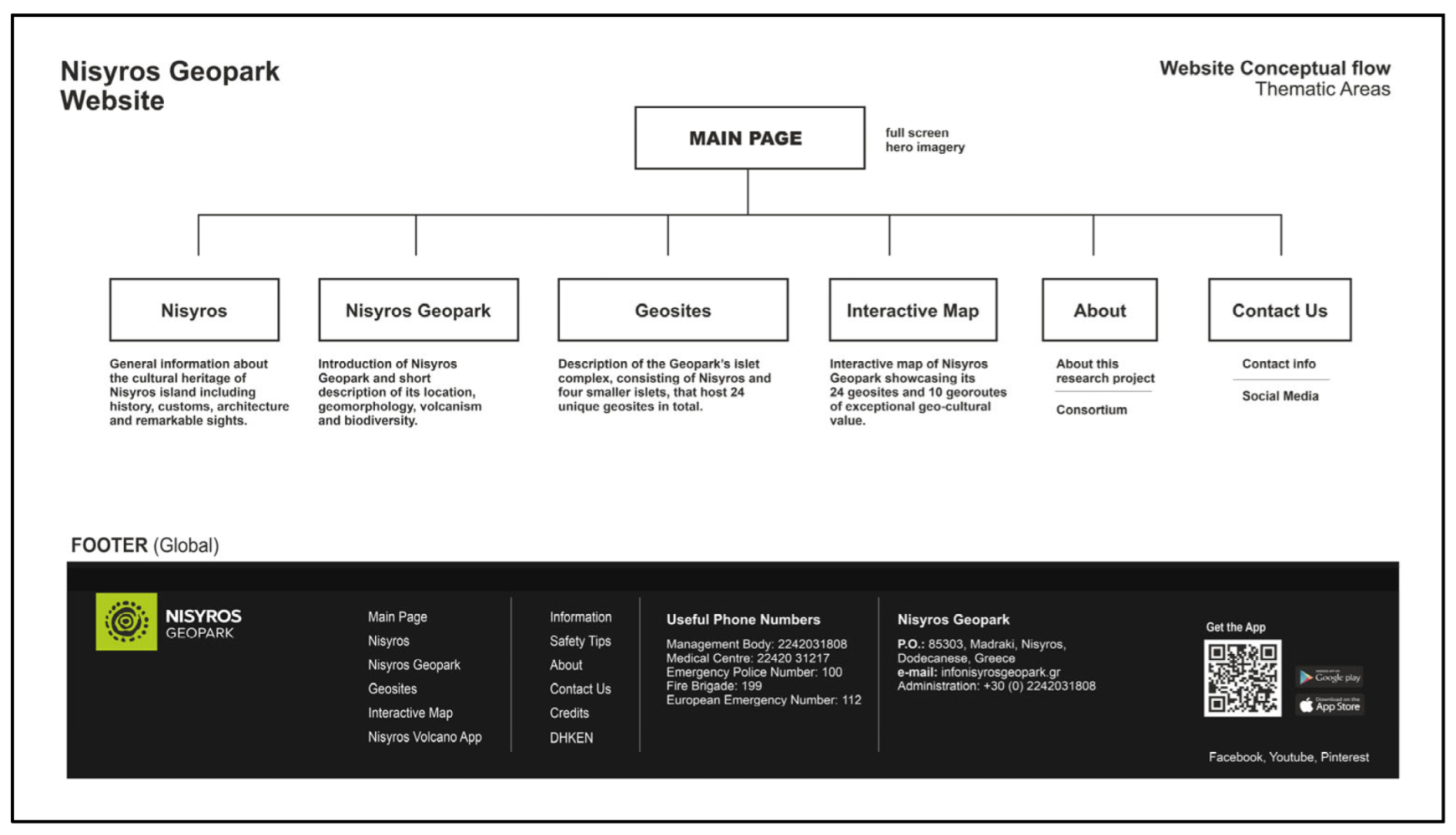
Article

Nisyros Aspiring UNESCO Global Geopark: Crucial Steps for Promoting the Volcanic Landscape’s Unique Geodiversity

by
Paraskevi Nomikou
1,*,
Dimitrios Panousis
1,
Elisavet Nikoli
1,
Varvara Antoniou
1,
Dimitrios Emmanouloudis
2,3,
Georgios Pehlivanides
4,
Marios Agiomavritis
5,
Panagiotis Nastos
1,
Emma Cieslak-Jones
1 and
Aris Batis
5
1
Department of Geology and Geoenvironment, School of Science, National and Kapodistrian University of Athens, Panepistimioupoli, 15784 Athens, Greece
2
Department of Forest and Natural Environment Sciences, School of Geotechnical Sciences, International Hellenic University, 66100 Drama, Greece
3
UNESCO Chair on Conservation and Ecotourism of Riparian and Deltaic Ecosystems, 66100 Drama, Greece
4
Hands-On Studio, Research and Art Direction, Branding, UX/UI Design, Project Management, 54655 Thessaloniki, Greece
5
Econtent Systems P.C, Software, Website and Mobile Application Development, 15784 Athens, Greece
*
Author to whom correspondence should be addressed.
Geosciences 2023, 13(3), 70; https://doi.org/10.3390/geosciences13030070
Submission received: 27 January 2023 / Revised: 21 February 2023 / Accepted: 27 February 2023 / Published: 1 March 2023

Abstract

:
Nisyros Geopark, an island geopark in the Southeastern Aegean Sea, Greece, is here presented as an official candidate for the UNESCO Global Geoparks designation, featuring outstanding geological, natural and cultural characteristics tightly connected to its volcanic origin. It covers a total area of 481 km2 and includes Nisyros, an active volcano and the main island, the surrounding islets of Pachia, Strongyli, Pergousa, Kandeliousa and the marine region among them. It features 24 geosites and a network of well-established walking trails. Furthermore, there are two internationally designated Natura 2000 areas covering its entire surface and also exceptional archaeological and cultural sites, including fortresses, remnants of ancient habituations and numerous churches and monasteries. It is the only area in the broader region of the Eastern Mediterranean that hosts all these features within such a restricted area. The initial efforts of the management body of Nisyros Geopark and its scientific team to promote its unique geodiversity included the complete design, construction and launch of the official website, the mobile application “Nisyros Volcano App’’, a modern informative leaflet regarding the region of the hydrothermal craters (Lakki), a Geopark guidebook and a series of panels and signs for the geosites.

1. Introduction

Throughout the history of Earth, complex geological processes gradually shaped every aspect of the environment of a living, dynamic world that became home to countless life forms and, eventually, humans. As the evolution of geosciences worldwide uncovers the scientific importance of the different stages of the planet’s evolution, it has become apparent that geology and the landscape provided the seeds for humanity to flourish and develop. Thus, the need for protection, conservation and promotion of the many geological and geomorphological monuments that are scattered all across the globe has slowly initiated new forms of geology-related education, tourism and other environmentally responsible activities seeking to uncover and preserve the roots of modern-day societies. Geotourism, a form of alternative, sustainable and responsible tourism that focuses on discovering a region’s geological and geomorphological heritage, is recently becoming more and more sought after, not only by earth science enthusiasts, but also by the broader public [1,2]. It offers opportunities for exploring the history of the Earth through geosites, sites of unique geological and geomorphological value, and geotrails that promote an area’s geodiversity, thus attracting the interest of a significant number of tourists in an area [3]. At the same time, it is helping a new type of environmentally aware and geo-culturally respectful tourist to emerge, through proper educational activities based on simple and understandable scientific information dissemination methods, both traditional and digital [4,5,6,7]. Thus, geotourism, along with all the educational value it has to offer, has become a powerful tool for the sustainable development of local and regional communities [1]. The best way to enhance and further diversify the geological value of an area, with geotourism and education, while incorporating local communities and all the other aspects of local societies in a sustainable development manner, is through the initiative of UNESCO Global Geoparks (UGGps) [8,9,10].
According to [11], ‘UNESCO Global Geoparks are single, unified geographical areas where sites and landscapes of international geological significance are managed with a holistic concept of protection, education and sustainable development’. Having the area’s geological heritage at their core, they form uniquely diverse societies where topics regarding the sustainable use of the Earth’s resources, the mitigation of the effects of climate change and the reduction of the impact of natural disasters are enhanced and connected to all other aspects of the area’s cultural and natural heritage [12,13]. Hence, they strengthen shared cultural bonds among their communities, create resilience regarding possible geological threats that may affect those communities, and enhance the quality and quantity of economic activities, education and geotourism, all while the geoheritage of the area is protected. UGGps were first established in 2015 [14], although the initiative for the promotion and preservation of geological features through a holistic approach involving biological, cultural, tangible and intangible heritage, as well as the local communities, had already been around since the mid-90s [2,5,15]. They are established as a bottom-up process that involves all relevant local and regional stakeholders and authorities, thus demanding a strong and lasting commitment of the local communities, as well as local multiple partnerships with long-term support by all parts of the local society, both public and political. Thus, UGGps, along with the other two UNESCO site designations (Biosphere Reserves and World Heritage Sites), provide a complete visibility and conservation schema for the world’s most outstanding and endangered cultural, biological and geological diversity [11]. Today, there are 177 officially recognized UGGps in 46 countries spread across all continents (as of December 2022), each one been connected to regional and continental networks, which are the European Geoparks Network—EGN, the Asia-Pacific Geoparks Network—APGN, the Latin America and the Caribbean Geoparks Network—LACGN and the newest African UNESCO Global Geoparks Network (AUGGN) [16].
For an area to become a UGGp, a series of crucial steps needs to be taken in order to prepare the application dossier and then function as a de facto UGGp for at least one year, before eventually undergoing its evaluation process. During this period, the area is referred to as an Aspiring UNESCO Global Geopark (aUGGp). It must adhere to the four essential values that a UGGp incorporates, which include geological heritage of outstanding international value, as it is implied by thorough research and scientific publications, a strong management body with legal existence under a national legislation, enhanced visibility through sustainable geotourism and geoeducation, as well as strong networking capabilities [2,11]. Gradually, an aspiring Geopark must incorporate within its local communities, local stakeholders, political entities and facilities a management plan focusing on the ten most important topics within a UGGp: the sustainable development of all its inhabitants, as well as the wise exploitation of the area’s natural resources; the promotion of awareness of possible geological hazards and climate change, their impact and their mitigation; the encouragement of new and innovative scientific research and public dissemination of its results on topics regarding the geological heritage of the Geopark, geoconservation, as well as its cultural history, local and indigenous knowledge and the empowerment of women through the development of their cooperatives [2,5,9,11,12].
Of particular interest is the aspect of visibility of a UGGp, which is mainly achieved not only by its network, but also through its geotourism initiatives that stem from a strong educational plan primarily focusing on sustainability. The development and promotion of educational activities for all kinds of audiences is a substantial factor that can determine a Geopark’s positive impact both on local societies and tourists, thus offering a better understanding of the importance of the geological, biological, cultural, tangible and intangible heritage of the area. This understanding will then provide the roots for a further appreciation and respect for the Geopark’s natural and human environment, which will eventually guarantee the conservation of geoheritage [8]. It will also play a decisive role in the UGGp’s contribution to the fulfillment of the 17 United Nations Sustainable Development Goals (SDGs), that comprise the Agenda 2030 for Sustainable Development adopted by the United Nations [17,18]. Thus, sustainable educational activities within Geoparks should always be supported by local schools, academic institutions and universities, and include training activities not only for students, locals and tourists, but also for teachers and special tour guides, in order to establish responsible promoters of the area’s geo-cultural and natural environment. The involvement of the geoscientific community, that comprises the core of the activities provided by a UGGp, is crucial for the achievement of these goals [19].
The promotion and communication of scientific information through innovative educational initiatives has started shifting from traditional means, such as books, leaflets and classic informative panels, towards more digital approaches that further improve the educational and geotouristic value of a UGGp. During the past few years, many Geoparks have adopted initiatives regarding the implementation of digital technologies (GIS mapping, websites and mobile applications, UAVs) in many aspects of their provided services, particularly for geoeducational purposes and to enhance the management of their geoheritage, thus providing innovative and diversified geotourism opportunities [13,20]. Those include examples of digital 3D virtual geo-routes [21], virtual field trips and virtual reality environments [22,23]. In this way, accessibility to almost every aspect of a Geopark is gradually made far more possible in a world where modern everyday life is primarily carved by technology, thus opening a window to some of nature’s most beautiful and unique places worldwide that the UGGps represent, and communicating their social and environmental goals [24]. However, as more and more people, especially younger audiences, refer to technological developments like computers, smartphones and tablets both for recreational and educational activities, the need to spread the concept and goals of UGGps more easily to the wider public has gradually led to the development of geotouristic mobile applications [13,25]. Such applications would have a greater educational impact on younger audiences and inspire them to discover what a UGGp has to offer.
The aim of this paper is to present the initial efforts of the management body of Nisyros aUGGp, Greece, toward the goal of achieving the UNESCO Global Geopark status, through a series of both traditional and digital developments focusing on the introduction of the Geopark’s extraordinary features to the global geotourism and geoeducational scene. These included the design, construction and installation of informative panels and signs on the designated geosites, as well as signs indicating possible hazardous areas at the most important geological attractions of the main island of Nisyros. A new, informative leaflet regarding the hydrothermal area of Lakki was also produced, with a unique and innovative foldable, poster-like design, as well as a comprehensive, plain language Nisyros Geopark guidebook, describing all aspects of the Nisyros Geopark. Finally, two digital products were also highlighted, the official Nisyros Geopark website and the first free informative mobile application for the touristic exploration and geo-interpretation of the area of Lakki within the volcano’s caldera.

2. Nisyros Aspiring UNESCO Global Geopark

The Nisyros aspiring UNESCO Global Geopark (Nisyros Geopark) is an island complex located between Kos and Tilos islands (Dodecanese prefecture) in the southeastern part of the Aegean Sea in Greece. It includes Nisyros island, the youngest—and still active—volcano of the South Aegean Volcanic Arc, together with the surrounding volcanic islets of Strongyli, Pachia, Pergousa, the non-volcanic islet of Kandeliousa as well as the marine area between them (Figure 1). It occupies a total land and sea area of 481 km2.
Nisyros Geopark is an active volcanic field located in the South-Εastern Aegean Sea, and is part of the South Aegean Volcanic Arc (also known as the Hellenic Volcanic Arc), a chain of active Quaternary volcanoes that stretches from mainland Greece (Sousaki, Methana) to the southeastern corner of the Aegean (Milos, Santorini Volcanic Field and Kos-Yali—Nisyros Volcanic Field) [26,27]. Being part of the Dodecanese group in the eastern Aegean Sea, and located between the islands of Kos and Tilos, it lays within a prehistoric volcanic field that generated the largest volcanic eruption in the Eastern Mediterranean Sea (Kos Plateau Tuff), 161,00 years ago [28,29,30,31,32]. With only 160,000 years of volcanic activity, following the tremendous eruptive cycles of Kos Plateau Tuff, Nisyros is considered Greece’s youngest active volcanic edifice [33].
From a geodynamic perspective, Nisyros is located within one of the most tectonically complex regions of the eastern Mediterranean, featuring important geodynamic events that eventually shaped the area and gave birth to the volcano [34,35,36]. The dominant geodynamic events that characterize the region are the ongoing northward subduction of the African plate beneath the Eurasian plate, along with an extensional geodynamic regime that has been established within the entire Aegean Sea region since the Late Miocene, leading to the thinning of the continental crust accompanied by the development of a series of fault systems that accommodate deformation (Figure 2 and Figure 3). As a result of the above processes, the entire region of the eastern Aegean Sea has been subjected to the development of graben—horst systems, bounded by faults. In the southeastern Aegean, the submarine area between Kos and Tilos islands constitutes a regional graben, through which hot molten rock produced due to the subduction rises to upper lithospheric levels and finally to the surface, thus creating volcanism [37]. Over the past 160,000 years, volcanic products have filled the regional graben, giving birth to the Nisyros volcanic complex.
Systematic research has been taking place in the region for many years, yielding important results regarding the volcano both from onshore and offshore observations, and in many fields of geosciences, including volcanology, geochemistry, geophysics, oceanography and seismology [38,39,40,41,42,43,44,45,46,47,48].
Thanks to that research, it is now known that Nisyros and the surrounding islets of the Geopark are entirely composed of volcanic rocks, apart from Kondelioussa, which consists of Mesozoic limestones and forms a small-scale regional horst between Kos and Tilos [49]. The volcanic evolution of Nisyros is divided into five eruptive cycles, each one of which produced volcanic products such as lava flows of variable composition, pyroclastic deposits such as tuff and pumice successions, domes, the caldera, hydrothermal craters and faults. They consist of the ‘Submarine Volcanic Base’ cycle, the ‘Early Shield Volcanic cycles’, the ‘Composite Stratovolcano’ cycle, the ‘Caldera Forming’ eruptive cycle and the ‘Post-Caldera’ eruptive cycle, leading to the currently active hydrothermal system [33].
As a result of its volcanic history, the region hosts spectacular onshore and offshore geological formations that clearly depict the stages of the volcano’s evolution, as well as breathtaking geomorphological landmarks such as the iconic caldera, domes, offshore basins and canyons. It is also home to a spectacular active hydrothermal system that has endowed Nisyros with a number of hot springs along its coastline, hot steam emissions, fumaroles and of course the hydrothermal craters at Lakki. Some of the designated geosites of international value of the Geopark are Stefanos Crater, one of the largest and most well-preserved hydrothermal craters in the world featuring degassing fumaroles (Figure 4 and Figure 5a), the Parletia lava neck at Nikia (Figure 5b), the scoria cones at Avlaki, the volcanic cone of Strongyli to the north of Nisyros and the voluminous pumice deposits at Cape Katsouni.
Apart from research, the region’s rich geodiversity attracts the interest of many students and early career scientists, thus giving them the chance to work on an open geological laboratory [50,51,52]. It is an ideal place for excursions of scientists, students as well as the public in general, because it is the most characteristic and interesting volcanic edifice in Greece and hosts well-preserved geological and geomorphological formations, which not only produce scientific results, but also disseminate information in an easy-to-understand manner [7].
Figure 5. Nisyros is a prime example of an open volcanological laboratory, featuring a number of geological features of great educational and scientific interest: (a) Active fumarole within the bottom of Stefanos Crater, with characteristic sulfur deposits (crystals) formed around its vent. Approximate diameter 3–4 cm; (b) The Parletia Mound, one of the best examples of a rhyolitic lava neck formed between the two successive eruptions of the Caldera Eruptive Cycle of Nisyros [33]. It is exposed on the eastern caldera wall at an approximate altitude of 300 m a.s.l.
Geosciences 13 00070 g005
The flora and fauna of Nisyros Geopark present great interest both because of the volcanic nature of the region and also due to its geographic position on the immigration routes of the Asian species towards southern Europe and vice versa. There are two areas that belong to the European network Natura 2000 (areas GR4210032 and GR4210007) and three areas identified as Wildlife Refuges. The documented presence of 450 species of flora and 85 species of avifauna highlight Nisyros as a place worthy of special protection and study. This also includes seven species of reptiles, like Kourkoutavlos (traditional name of the lizard Agame stelio)—huge black and brown lizards hiding under volcanic rocks— as well as the presence of Monachus monachus—Mediterranean seals on its shores. The dense bushy vegetation includes the thorny burnet (Sacropoterium spinosum), the lavender (Lavandula stoechas), the hoary rock rose and Gallipoli rose (Cistus criticus and Cistus salvifolius), the thyme (Thimus capitatus), the laurel (Daphne gnidioides) and the Nisyros bellflower (Campanula nisyria), which is a unique endemic plant species.
Nisyros Geopark goes beyond presenting a unique volcanic history and the beauty of its nature. It is found at the crossroads between western and oriental civilizations, and the fascinating cultural and historical heritage of the island is courtesy of its geographical position and its circular and mountainous volcanic morphology, making it a rather inaccessible island, where values are more easily preserved [53]. It also exposes the splendor of art and civilization, expressed through prehistoric and historic locations and monuments. Prehistoric witnesses are present from Early Neolithic times, in the form of relicts from the Cycladic and Minoan civilizations, while historical records start from the Hellenistic epoch and continue uninterrupted through Roman, Byzantine, Venetian and Ottoman eras, into modern times [54,55,56]. Each of these periods has enriched the region with ancient caverns and spas, magnificent castles like Palaiokastro, the most well-known fortress of Nisyros (Figure 6), churches and monasteries with hagiographic frescoes (like the Monastery of Panagia Spiliani). In this respect, and considering its small size, Nisyros aUGGp differs from all Dodecanese and Aegean islands and stands out as a strong candidate for UNESCO’s Global Geoparks project.
In charge of the operation of Nisyros Geopark is the Municipality of Nisyros in cooperation with the Municipal Public Benefit Enterprise of Nisyros (DIKEN). All decisions regarding the financial management and daily operation of the Geopark are also made by the Municipality of Nisyros in cooperation with DIKEN. As a result, local participation in decision-making is guaranteed. Moreover, some of the employees of DIKEN, who may be considered as local decision-makers, participate in the administrative scheme of the Geopark’s management body; hence, having an important role in the decision-making process. The Geopark’s management body president is the Mayor of Nisyros.

3. Materials and Methods

For the communication, promotion and networking needs of the Geopark concerning both the public and institutional bodies, an integrated communication strategy was formulated. The practices followed were: (a) the initial design of the Geopark’s corporate identity; (b) the design and development of the institution’s website; (c) the design of a series of printed information materials and specially designed signage (environmental graphics) for the needs of the Geopark; (d) the design and development of a multimedia application specially designed for smartphones for both Android and iOS environments. The main objective of the communication strategy followed was for the distinctive features of the above actions to reflect the recognition of the institution as a geo-environmental monument of unique and global value in a modern way. For this purpose, an extensive study and research was conducted in the first phase regarding the design of corporate identities in related institutions and Geoparks, as well as the specific characteristics of architectural information and design trends utilized by their respective websites. Based on the research conducted in this first stage, the Geopark’s corporate identity was designed and developed, as well as a series of specially designed icons aimed at conceptually representing the main activities and characteristics of the Geopark.
In a second stage, after extensive research, the UX/UI (User Experience/User Interface) design solutions for the needs of the website were formulated through a human-centered design approach, focused on responsive design and covering both its use through desktop computer systems, as well as through smartphones and tablets. For the needs of the website, with specialized functionality regarding publicity and communication, a content management platform system (CMS) was formulated, which supports the posting and publication of relevant information material, announcements and other information. The website, as a communication and reporting hub for the Geopark’s activities, was designed with the following information architecture: Initial Page (Landing Page), Nisyros Page, Nisyros Geopark Page, Geosites Page and Interactive Map Page (Figure 7—see ‘Results’ for a complete description).
For the needs of the dissemination of information on the Geopark’s activities, a leaflet with a modern design and easy-to-understand content was produced, aiming at providing sufficient information and comfort of use by visitors and locals alike. The brochure, in the form of a foldable poster, provides rich informational material backed by scientific data on the geology of the Geopark, as well as historical facts concerning Nisyros, enriched with a specially designed topographical map of the Geopark area illustrating the paths and points of interest, featuring diagrams and photographic material. The leaflet provides a geological explanation of the points of interest (visitor observation points), useful information on potential hazards, appropriate clothing by visitors and other safety tips, as well as contact information by using a QR hyperlink directing to the geopark’s website.
In combination with the informational leaflet, a digital guide was designed and implemented for Nisyros Geopark in order to improve the services of the institution. The user of the application can discover the morphological characteristics of the area and learn about the history of the development of the Geopark through an interdisciplinary framework of up-to-date material.

4. Results

4.1. Website

The modern, responsive and fully interactive official website of Nisyros Geopark www.nisyrosgeopark.gr (accessed on 25 January 2023) constitutes one of the main digital communication tools of high quality and design, providing users with all of the initial information they need to be introduced to its various aspects and help them plan their visit (Figure 8 and Figure 9). The website is currently available in English, while its translations into Greek and other significantly spoken European and Asian languages are under progress and/or consideration. The Home section is the first level of communication (landing page) with the web visitor to the Nisyros Geopark. It showcases the main components of the website’s structure, which include the header with the linked subpages to further content, the main body depicting brief information about the Geopark as well as the footer that displays useful information for visitors. Upon official recognition of Nisyros as a UGGp, this level will be the most important in terms of information architecture, since it will essentially consist of live (daily updated) feeds/actions of the Geopark through dedicated sub-areas where the Geopark’s “Latest News”, the Geopark’s actions (Events) and various announcements will be hosted. These areas will provide rich informational material in a chronological order that will follow suit with the Geopark’s work/actions and progress through time.
The “Nisyros” section brings the visitor into contact with the island of Nisyros through the following subsections: (a) Mythology, (b) History, (c) Nisyrian People, (d) Customs and Traditions, (e) Nisyrian Villages, (f) Museums and (g) Sights. It starts with the mythological context about the creation of the region (Giantomachy, in ‘Mythology’), followed by the presentation of the long history of Nisyros with rich informational material (‘History’). The ‘Nisyrian People’ section provides important information about the modern history, folklore, customs and traditions of the island, with the aim of highlighting the unique intellectual wealth of Nisyros, as well as the work of important Nisyrians. The ‘Customs and Traditions’ section presents information material on the customs and traditions of Nisyros, the remarkable architecture of the island, the folk culture and the various cultural events of the island. The remaining three sections provide brief descriptions on the island’s four main villages, the different museums available for exploration as well as other important geological, natural and cultural sites around the Geopark.
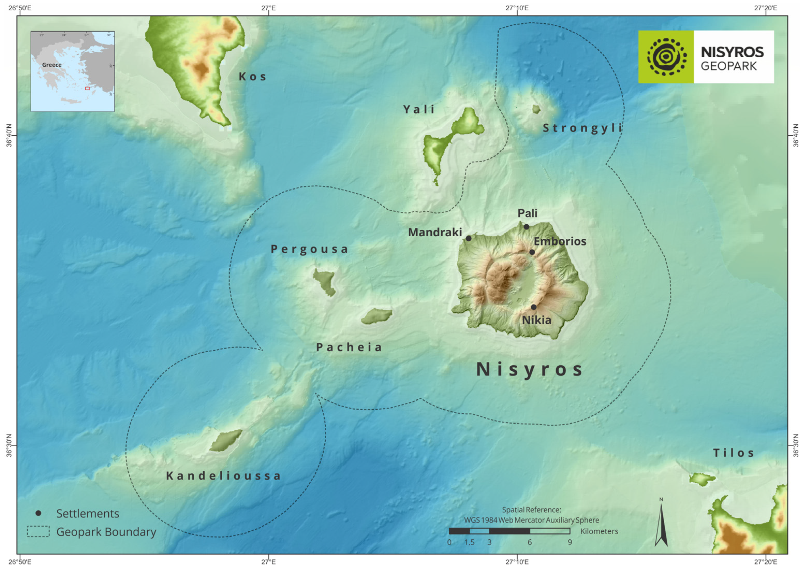
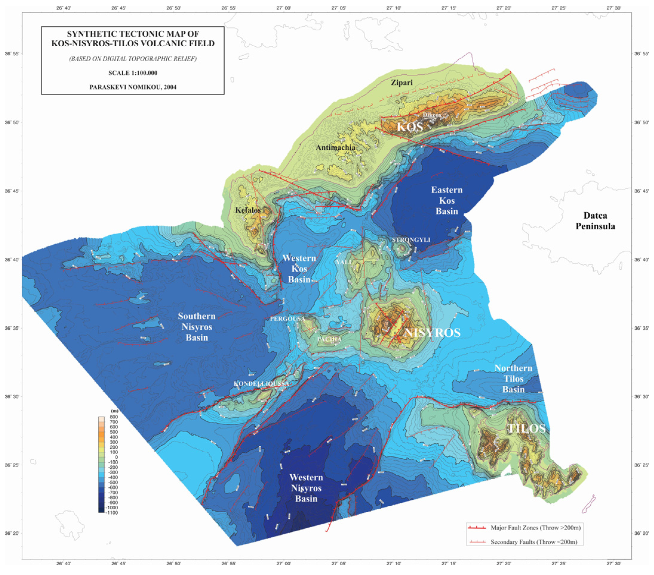
The section “Nisyros Geopark” introduces the visitor to the concept of the Geopark, which is directly linked to the geocultural environment of the island complex of Nisyros and the surrounding islets. Its subsections are: (a) Location, (b) Islets Complex, (c) Geomorphology, (d) Volcanism and (e) Biodiversity. The subsection ‘Location’ includes the clear geographical positioning of Nisyros Geopark in Greece, while the subsection ‘Islets Complex’ provides a brief description of the physical and anthropogeographical characteristics of both Nisyros and the individual islets that make up the Geopark. The subsection ‘Geomorphology’ lists the physiographic and morphotectonic features that make up the volcanic environment of the Geopark. In the subsection “Volcanism”, the visitor can get in touch with the rich geological history of the area. Finally, the subsection ‘Biodiversity’ provides useful information on the flora and fauna of the island complex of the Geopark, which thrive due to the fertile soils of volcanic origin and feature scarcity and interesting geographical spread.
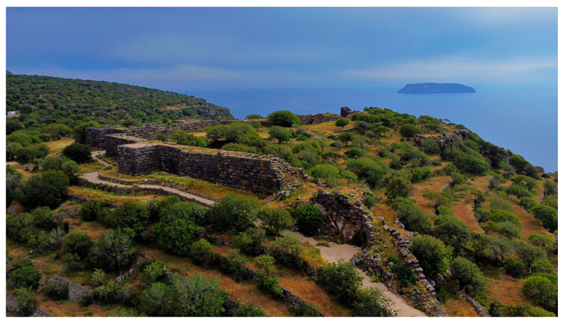
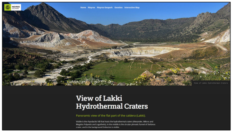
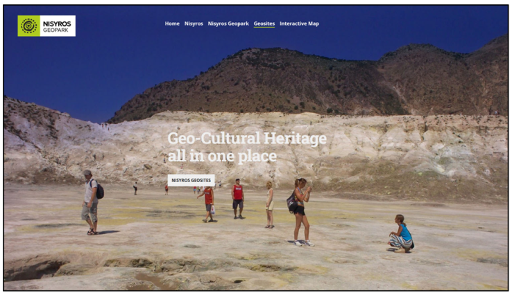
The “Geosites” section highlights the 24 designated geosites of the Geopark, providing all the important scientific information accompanied by visual material to the public. It is linked to the last section, “Interactive Map”, that presents the 10 proposed georoutes of the geopark while focusing on the interactive experience of the users through the interactive map that displays all the points of interest concerning the geological heritage. It consists of the sub-sections: (a) Geosites, (b) Georoutes and (c) Travels and tours. The subsections ‘Geosites’ and ‘Georoutes’ provide visitors with the opportunity to navigate the walking routes of the Geopark, with emphasis mainly on the island of Nisyros, through easy-to-use and user-friendly interactive maps with text, photos, video and sound. The subsection ‘Travels and tours’ will further diversify the website’s content in the future, by including interactive material concerning the other islets of the Geopark, so that visitors will have the opportunity to tour this remote region of the Geopark, currently inaccessible to direct visits.

4.2. Nisyros Volcano App

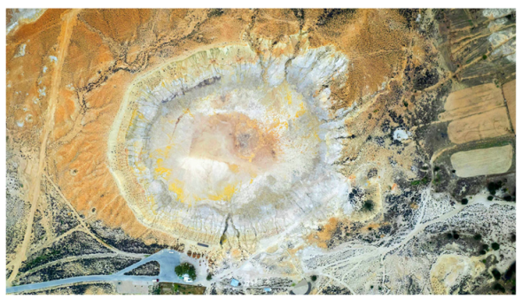
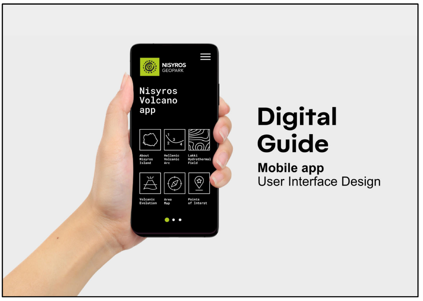
The Geopark’s first educational mobile application, named ‘Nisyros Volcano App’, is a free, offline and easy to use virtual guide focusing on the area of Lakki within the central caldera of Nisyros Volcano (Figure 10). This area was primarily selected due to its international geological significance, as it is located within the youngest volcanic caldera of the South Aegean Volcanic Arc and is a representative example of an onshore active hydrothermal field [31]. It comprises the eastern part of the caldera’s bottom, having a very smooth relief and featuring a number of active hydrothermal craters and lots of fumaroles. One of the craters, Stefanos, is the main touristic highlight of Nisyros Geopark and is one of the largest of its kind in the world [44].
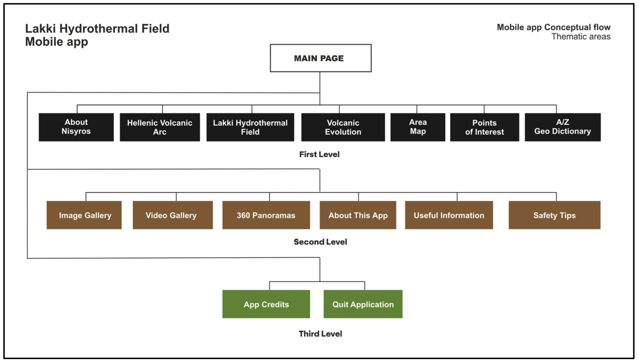
The app features an easy-to-navigate interface (main page) immediately accessed after the opening page once users hit ‘Enter’. All the information provided by the app consists of plain language text descriptions, high resolution photos, figures and videos, interactive 2D and 3D maps as well as 360° panoramas. It is organized into three main informational levels, each one of which represents a set of subunits on the interface.Users can easily swipe from one level to another, to find different subunits corresponding to the type of information they want to access (Figure 11). On the upper right side of the main page is a hamburger menu providing instant access to all the subunits of the app, while two buttons were more recently added to provide access to the smartphone’s camera, giving the ability to scan the different QR codes used at the Geopark’s services. As with the website, the app is currently available in English, while its translations into Greek and other significantly spoken European and Asian languages are under progress and/or consideration.
The first informational level consists of six subunits. The first subunit is named ‘About Nisyros Island’ and provides a first, brief but efficient introduction to the geological and cultural environment of the island. It presents the geographic and geodynamic position of the island, describes the main types of geological and geomorphological features that make it unique and links its volcanic history to the rich ancient Greek mythology, which had already attempted to geo-interpret the active volcano’s behavior. Preceding the text is a simplified interactive map of Nisyros that features five important points of interest, which are the four settlements of the island: Mandraki, the capital and main port, Pali, Emborios and Nikia, as well as the Lakki Hydrothermal Field. Users can touch each one of those points to access a page that provides additional information regarding not only the settlements themselves, but also other significant archeological, cultural or even spiritual points of interest nearby. The descriptions are accompanied by a dedicated image gallery, through which users can admire high resolution photos of a given point of interest, complete with plain language captions.
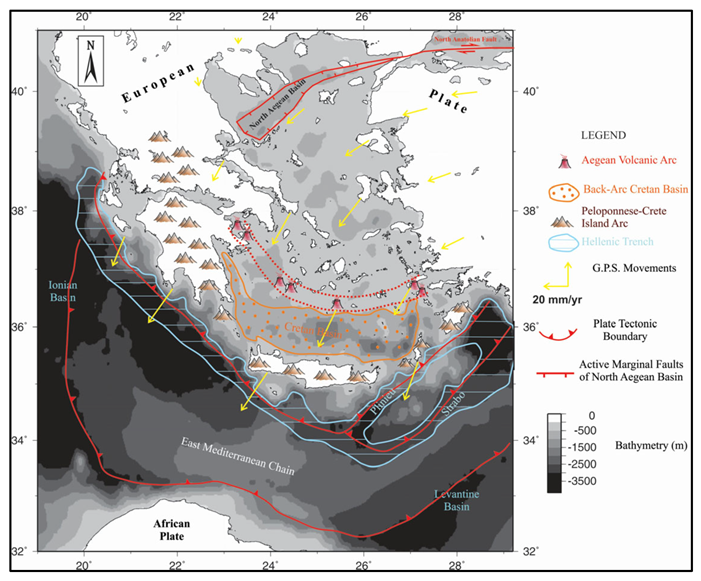
The second subunit is named ‘Hellenic Volcanic Arc’ and its information provides the first step in understanding the general geodynamic regime in which volcanism at Nisyros occurred. It gives a plain language explanation of the complex geotectonic processes that have shaped the southeastern region of the Aegean Sea for the past millions of years and gives additional details about the other volcanic centers that comprise the Hellenic Volcanic Arc, along with a simple, static map showing their location. By placing the Geopark’s geological highlights in a broader context that also includes other well-known islands in the Aegean, like Santorini and Milos, its outstanding geological heritage can be made easier to understand, and thus, noticed and admired. It is important to note that the informative text here, and also in other subunits of the app, is presented as both a short and a long version. The short version gives an efficient description of the most important information on each topic, while the long version takes this a step further, by providing additional details for visitors who have more time in the area or who want to explore more later at home. The short version is not cut in half, with the remaining text in the longer version, but instead is a complete paragraph itself. To access the longer version, users must touch the ’more’ button.
The third subunit is named ‘Lakki Hydrothermal Field’ and specifies the geological processes that power one of the most impressive such fields for the past 24,000 years. It describes what a hydrothermal crater is and how it can form, while providing a comprehensive graphic timeline of the history of the hydrothermal craters over the years. The goal of this subunit is not only to scientifically describe the hydrothermal field, but also help users realize the important difference between the type of eruption that formed the impressive craters and the volcanic eruptions of Nisyros in general. The timeline also aims to give an age context of the craters, thus proving the undoubtable bond that connects volcanism with the local communities of Nisyros, who both struggled and were benefited throughout the island’s history.
The fourth subunit is named ‘Volcanic Evolution’ and is one of the most important throughout the app. It describes the six eruptive cycles that gradually built Nisyros over the past 160,000 years, from mild underwater volcanic activity to a composite stratovolcano that produced voluminous eruptions and eventually formed the edifice seen today [33]. The successive eruptive cycles of Nisyros are individually presented at the end of the subunit, in a form of a timeline that consists of the title of each cycle, a short text description and a high-quality Digital Elevation Model of Nisyros island, highlighting the areas covered by each volcanic cycle’s eruptive products. This way visitors are provided with a first means of geo-interpretation for the entire island, as the information can be used to start describing the different volcanic products of Nisyros, regardless of the app’s main focus on Lakki hydrothermal field.
The fifth subunit is the Lakki Hydrothermal Field ‘Area Map’, and the core of the mobile application. It is a virtual guide that gives the opportunity of exploring the three designated points of interest within Lakki, by providing a comprehensive 2D and 3D map of the area. At the beginning, an informative text gives general directions on the accessibility and safety of Lakki, and presents the three points of interest (Stefanos Crater, Lofos Hydrothermal Area and Polyvotis Craters). By exploring the map, users will then find a 2D map of the Lakki area, that includes the location of the craters along with their official names, the main asphalt road that leads to Lakki, the three points of interest and the walking trails that connect them. While in the area, the user’s location is also visible in real-time, without the need for an internet connection. This further improves the accessibility to the points of interest, as it can be combined with the informative panels and directions directly found on site. A complete legend of the map can be activated or hidden by touching the button to the right of the 2D mode (Figure 12). The button to the right of the Legend activated 3D mode. Again, visible are the main asphalt road, part of the broader ‘Caldera—Lakki’ route (one of the ten official georoutes of Nisyros Geopark), the walking trail and the points of interest. This time, the identification of the geosites is easier due to the use of a satellite image background for the map. The final button to the right activates the elevation of the walking trail. It is a useful addition for the app, because it can help plan an excursion at the area by providing the changes in elevation, giving visitors an expected level of difficulty for the georoute. All the points of interest both on the 2D and the 3D maps are interactive and connect to the next subunit.
The sixth and final subunit of the first informative level is the ‘Points of Interest’ table. It provides detailed information about the geology of the three designated points of interest (geosites) within Lakki, which are Stefanos, the larger hydrothermal crater at the bottom of which visitors can walk, Lofos Hydrothermal area and the Polyvotis Craters. It complements the descriptions with a collection of impressive photos from each of the geosites.
The second informative level consists of another six subunits (seven to twelve). The seventh subunit is the ‘Geo Dictionary’. It is an A–Z dictionary that explains complex but important terms used throughout the informative texts of the mobile application, including not only geological, but also other terms as well. The goal of the dictionary is to ensure that users will make the most out of the educational purposes of the app, even when it is impossible to avoid the use of scientific words that a non-specialist audience may not be familiar with. For this reason, the Geo Dictionary can also be accessed by touching underlined terms found within the text of other subunits throughout the app. Doing so will instantly bring the user to the term’s description within the dictionary. It also simplifies additional geologic terms that may be encountered during a visit at the Geopark or in general. The enrichment of the application by adding this dictionary was considered a necessity, primarily due to the lack of such easy-to-use explanatory means by other Geoparks.
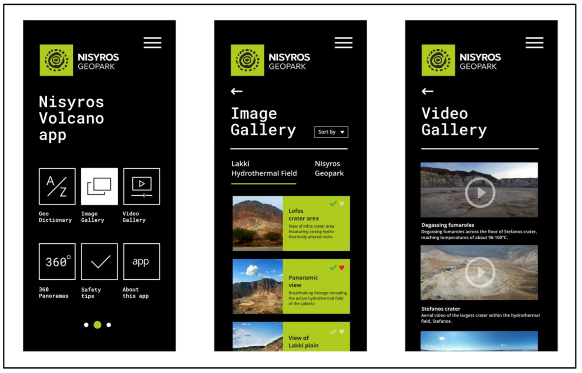
The eighth subunit is the ‘Photo Gallery’ of the app. It includes the best of the high-resolution images used throughout the app, both from the Lakki area and the rest of Nisyros Geopark. The layout of the gallery is such that users are aware of all the photos they have already seen (a green check mark appears on the upper right of the photo). They can also select their favorites, by activating the heart icon on the upper right of the photo, and then accordingly short all the images, on the ‘Short by’ button. Upon selection of an image, the rest appears at the bottom of the interface, providing instant access. All photos are accompanied by a title and a short explanatory caption (Figure 13).
The ninth subunit is the ‘Video Gallery’ of the mobile application. It includes four high resolution aerial videos filmed by the Geopark’s cooperation colleagues by using photography UAVs. The videos present stunning high-altitude views of the hydrothermal field, aerial views of Stefanos and the degassing fumaroles found at its interior, as well as a flight within Megalos Polyvotis crater. Users can play, pause and select a different time marker at any given moment when viewing the videos.
Another spectacular addition to the mobile application is the tenth subunit, the ‘360 panoramas’. It includes three high resolution UAV panoramas that can be interactively explored at all directions, giving the idea of flying above Nisyros. Views are provided for Lakki, the Polyvotis craters and the caldera of Nisyros, above the Nikia settlement.
Complying with the regulations of UNESCO regarding safety and geoconservation, the eleventh subunit of the app presents the ‘Safety Tips’ of Nisyros Geopark. It is a comprehensive catalog of 12 points that include rules and suggestions for the safety of visitors, as the area is an active volcano, and also for the protection of geological and natural heritage.
Finally, the twelfth subunit ‘About this app’ provides a brief explanation of the purposes of the mobile application, its connection to the official website of Nisyros Geopark and its availability.
The third and last informative level of the app consists of the remaining three subunits. ‘Useful Info’ describes the operational framework of Nisyros Geopark and provides useful links, phone numbers, social media and websites for the Municipality of Nisyros, Nisyros DIKEN and Nisyros Geopark. ‘App credits’ includes credits to the scientific and technical team that gathered the informative material, the photos and videos, wrote the texts and developed the mobile application (Figure 14). It also includes selected references and papers that helped with the scientific aspect of the texts. Finally, the ‘Exit Application’ subunit allows for instant deactivation of the app.

4.3. Leaflet

The purpose of the new informative leaflet of Nisyros Geopark is to further complement the services provided by the ‘Nisyros Volcano App’, once again regarding the Lakki hydrothermal area. It includes brief sections of the main information that is also presented within the app, while focusing on the area’s 2D and 3D maps. Thus, an alternative, more traditional way of navigating through Lakki is provided, allowing for full accessibility of the region for locals and tourists that do not have the means or simply do not want to download and install the mobile application.
Each foldable level of the leaflet presents, step by step, the geological frame and history of Nisyros, starting with the general geodynamic setting and eventually focusing on the three points of interest at Lakki. The first foldable level includes a brief introduction to the Lakki hydrothermal field of Nisyros, along with the Geopark’s logo and the official website on the front side. On the rear side, it features 11 simple but significant pieces of safety information, as determined by the scientific team that studied the volcanic landscape and visited all the included touristic spots within Lakki during all seasons. It is very important for these ‘Safety Tips’ to be the easiest to access; thus, they are included both within the mobile application and the very first foldable level of the leaflet.
The second foldable level focuses on the South Aegean Volcanic Arc (or the Hellenic Volcanic Arc), presenting a brief description of its geodynamic setting, history and the location of Nisyros Geopark within it. It also provides an over simplified map of southern Greece, highlighting the location of the other volcanic fields that belong to the arc, as well as the boundary along which the subduction of the African plate beneath the Eurasian plate takes place.
The third foldable level presents the six successive eruptive cycles of the volcano. It includes a brief description regarding the scientific methods that contributed to deciphering the volcanic evolution of Nisyros, and then showcases six detailed geologic maps with the land cover of each cycle’s volcanic products, gradually forming the modern-day landscape of the island. It is therefore made clear to the reader that Nisyros is an entirely volcanic island and traces of its violent past can be found all along its region. It is also the first time that the most up to date volcanic evolution maps of Nisyros are used on an informative leaflet. This level provides a fine example of how the leaflet can be used along with the digital products; a visitor can gain instant insight into the volcanic cycles of Nisyros and then proceed to find out more within the mobile application, and even further at the Geopark’s website.
The fourth foldable level presents the Lakki area’s 3D map, an inclined satellite view with the main road to the hydrothermal craters highlighted (a road that is also part of the broader ‘Caldera—Lakki’ route, one of the ten official georoutes of Nisyros Geopark). It is a static, paper version of the map presented within the mobile application. Alongside the map, brief information and high-resolution aerial imagery of the points of interest are provided. The level also includes the elevation profile that illustrates the topography along the section of the ‘Caldera-Lakki’ route and the paths, while highlighting the location of the three points of interest.
Finally, the fifth foldable level is the full, unfolded extent of the leaflet with total paper dimensions of A2 (42 × 59.4 cm—Figure 15). It presents the Lakki area’s 2D map, based on a detailed digital elevation model. It includes the main road to the hydrothermal craters and other secondary parts of the road network, the location of the main such craters within Lakki, the three points of interest as well as the trail that connects them. Detailed altitude information is also provided (easy to discern contour lines) as well as the names and the peaks of the lava domes that fill the western part of the caldera and dominate the views above Lakki. An index map to the left of the unfolded poster showcases the entire area with the five distinctive islands that compose the landscape of Nisyros Geopark, while the Geopark’s website and mobile application are accessible via the provided QR code.

4.4. Guidebook

To successfully approach the closer (local communities) and wider (visitors) social environments of the Geopark, its scientific team decided to create a socially appealing, informative guidebook with the aim of scientific education and the rise of environmental consciousness. The guidebook condenses all available important information, regarding every aspect of Nisyros Geopark related to geology, archaeology, culture, activities, educational events, biodiversity and natural disasters.
The guidebook is titled ‘The Nisyros Geopark Guidebook’ and is a small, paper book of A5 dimension, with a durable cover and a total of 64 pages, written in English language with the aim of future translations in Greek and other widely used European and Asian languages.
The information presented by the guidebook is rendered through short, synoptic texts written in plain language. In this way, scientific content becomes easier and more pleasing to understand by audiences of all ages. Texts are accompanied by maps, diagrams, brief tables and rich photographic material, while instant access to the digital products is thoroughly provided via QR codes and links to the website and the Geopark’s social media accounts. The final product provides a traditional and artistic opportunity for easy reading, transport and use by visitors and locals alike, providing information that can be decisive even for planning a trip to Nisyros.
At the beginning is the special thanks section and the link to the Geopark’s social media. Then, readers encounter a general touristic map of Nisyros featuring the settlements, the location of the geosites and the georoutes. The map covers both pages of that particular section, to allow for a convenient use. Following are two pages that host the map’s legend and a geotouristic index map of the entire Nisyros Geopark, also showcasing its general geographic position (Figure 16).
The main content of the guidebook then starts, with general information on the geodynamic context that gave birth to volcanism in the area, the mythological background established for millennia by the island’s first inhabitants as well as a brief description of the history and culture of Nisyros, from past centuries to present.
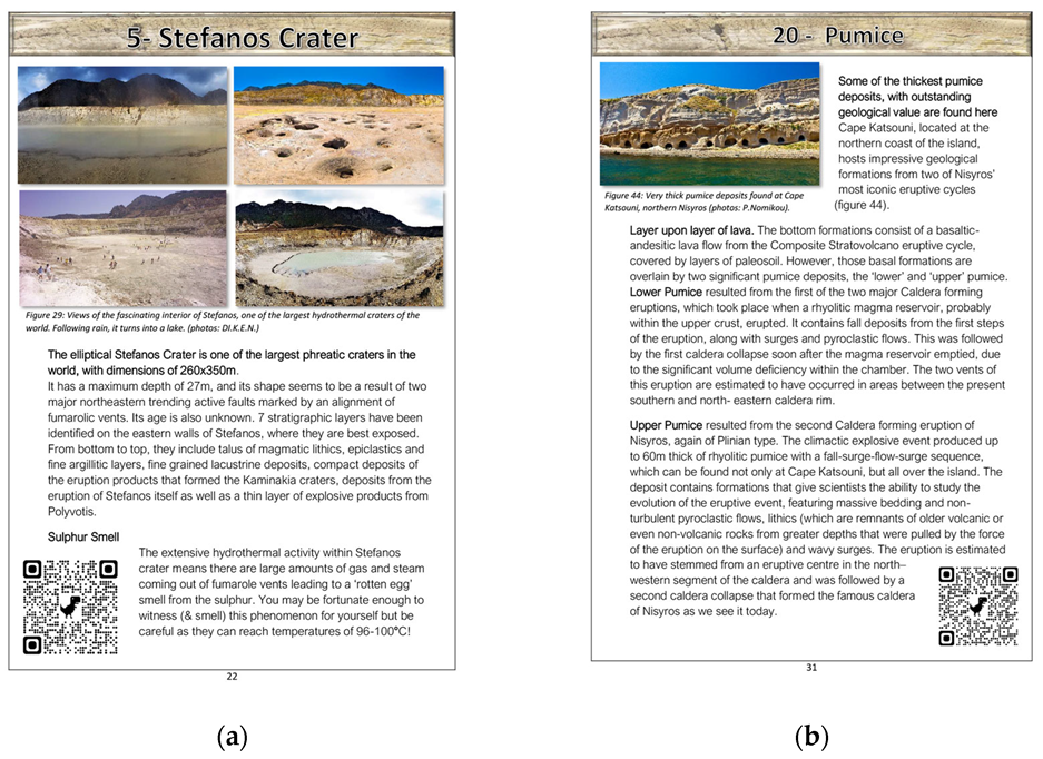
What follows is the detailed presentation and description of the 24 official geosites of Nisyros Geopark. For each geosite, representative photographic material is provided along with highlighted geological, geoenvironmental and other useful information. All of the above are accompanied by special QR codes that link readers to each geosite’s dedicated page on the Geopark’s website, after being scanned by a smart mobile device (Figure 17). The section of the geosites descriptions is followed by the presentation of cultural and archaeological points of interest (museums, archaeological spaces). Then follow the main safety and function rules and regulations of Nisyros Geopark (Code of Conduct—Safety Tips). The appearance of the safety tips here, as well as in the mobile application and the leaflet, is necessary for the even management of the Geopark and, mainly, for the personal safety of all its visitors.
The following section of the guidebook offers a detailed presentation of the 10 georoutes of the geopark, having a similar structure to the geosites section. Again, it is accompanied by maps, photographs and also more useful information regarding the length of each georoute, the approximate traverse time, the difficulty level and the type of points of interest to be encountered along the way. This section also features QR codes that provide access to the website, where users can also search and use the digital interactive map of the Geopark, along with the guidebook. Following the georoutes description is a section dedicated to the Geopark’s unique and rich biodiversity.
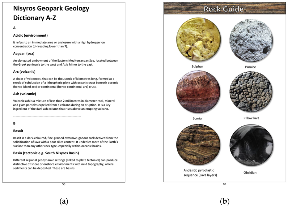
The final section of the guidebook consists of the Geoscientific dictionary, a concept realized by the Geopark’s scientific team that is also present within the mobile application (Figure 18). Its goal is the simple and efficient clarification of unknown and sometimes complex scientific terms that are used throughout the guidebook. This is the same as in the mobile application, but now accessible even through this traditional means of information dissemination, readers can search for a hard-to-understand term and gain more relative insight. What is an extra addition to the guidebook, not found in the mobile application, is an easy-to-use Nisyros rock type identification guide, following the dictionary. It can be used by people of all ages and has a primarily educational character, allowing for an easy identification of the basic igneous rock types found at the Geopark under the concept of a game.

4.5. Panels—Signs

A total of three geotouristic informative panoramas (panels) have been installed at the Lakki hydrothermal field, to the area’s three points of interest. The panoramas, which share the same design pattern, include high-definition representative photos of each of the points of interest, a short text description of their main geological highlight, their location within the elevation model of the route and a schematic timeline of events related to the activity of the hydrothermal system. They also include a QR code that links to the website, so that visitors can instantly gain access to more information about these important geosites. The panoramas are installed on an inclined, table-like mount of durable wood and placed on areas that do not prevent complete and unobscured observation of each geosite. A large geotouristic map of Nisyros island has also been installed at the main port of Mandraki, welcoming visitors and providing the first useful directions to the Geopark’s geosites, georoutes and other points of interest.
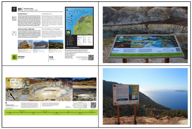
Apart from Lakki, twelve additional informative signs have been installed to the rest of the geosites, ten with dimensions of 60 × 40 cm and two with dimensions of 70 × 90 cm. Each of the signs consists of two different sections regarding the information provided for each of the geosites, written in both English and Greek. The first section is always about the geology of the geosites and the second is about other topics related to the geosite or its direct natural environment, such as biodiversity and cultural or religious significance. High resolution photos along with detailed captions are provided on every sign, showcasing other important places of interest directly related to the geosites. At the right side of each sign, a geotouristic map section is present showcasing the location of the current and neighboring geosites as well as georoutes, archaeological sites, churches, monasteries and other interesting places in the proximity. The final section of each sign contains the most significant rules from the Geopark’s Code of Conduct, regarding the respect and protection of the natural environment. It also includes useful information on the management body and a QR code linking to each geosite’s dedicated page on the Nisyros Geopark website (Figure 19).
In order to ensure the safety of the Geopark’s local communities and visitors, the installation of special safety signage regarding areas that are prone to landslides was considered a priority, not only to the proximity of the geosites, but also to other locations along the island’s road network, where the risk of a landslide is higher. Landslides at Nisyros are common and this is primarily due to the combination of the island’s steep morphology with the successive alternation of volcanic lithologies, each with a different degree of erosion. Especially during the autumn and winter seasons, extreme and sudden weather phenomena can produce significant landslide events.

5. Discussion

Nisyros aUGGp, an island geopark in the southeastern Aegean Sea, features outstanding geological, natural and cultural characteristics, making it an ideal candidate for UNESCO’s Global Geoparks list. Located at the southeastern edge of the South Aegean Volcanic Arc, it hosts dramatic landscapes shaped after the many volcanic eruptions of the past 160,000 years, each one with its own character, that left their scars both on the onshore and the offshore areas of the geopark. A fantastic trail network, along with 24 geosites, await both visitors, in order to give them the chance to easily explore the area and align with nature, and locals, to help them re-appreciate the place they call home. The offshore area of the geopark is constantly under the spotlight of scientific research of global impact, that has shed light on impressive underwater volcanic structures like craters, lava domes and fractures, as well as a pre-historic caldera, called Avyssos (the Abyss, for its depth of almost 700 m), from where the largest volcanic event of the Eastern Mediterranean occurred 161,000 years ago [30,31,32]. The offshore area features a number of basins, as well as a regional horst, Kondeliousa, a direct result of the complex geodynamic processes that shape the geopark’s broader region and the Dodecanese. These structures are bounded by significant faults that are still active up to this day, are well monitored and their study yields important details on the evolution of the area [49].
The cultural heritage of the area is also of great significance because, despite its small size, it has been constantly habituated for millennia. Directly linked to the myth of Gigantomachy and the fight between Polyvotis giants and Poseidon, the place has not only earned its place among the famous and globally known Hellenic mythology, but also inherited parts of the cultural identity of other civilizations who conquered it and controlled it. Impressive castles, like Palaiokastro—one of the most well-preserved Greek fortresses worldwide—the Mandraki castle, remnants of ancient habituations and a great number of churches and chapels from the Byzantine years have ultimately encapsulated the region’s history and given rise to the traditions and tangible and intangible heritage of locals today.
Tourist infrastructure development, educational activities, partnerships with neighboring UGGps, improvements in already existing structures and a management body that fully integrates local populations in the decision-making processes of the geopark, help make Nisyros Geopark a strong candidate. The educational and touristic material now includes publications, informative leaflets, signs and maps, while the new, modern and user-friendly website, along with the mobile application and several other educational tools, like a Story Map [7], complement the experience. As a candidate, Nisyros Geopark will join Greece’s seven other officially recognized UNESCO Global Geoparks in the Hellenic Geoparks Forum, which consists of the Geoparks of Lesvos, Psiloritis, Chelmos-Vouraikos, Vikos-Aoos, Sitia, Grevena-Kozani and Kefalonia-Ithaka. Out of those, only Lesvos Geopark features volcanic geoheritage, although its geological characteristics relate to extinct volcanism. Thus, Nisyros will be the second volcanic Geopark and Greece’s first active volcano to be included in the list once it achieves the UNESCO Global Geopark status.
Connection with the geopark is by boat from neighboring Kos, where people can get to either by boat from Piraeus port or by plane. The road network of the island, which is properly developed and combined with the trail network, helps visitors to visit every corner of the island. There are also marine activities that involve sailing around the island and visiting the surrounding islets.
Inspired by the actions and initiatives of many other UGGps over the past few years, especially during the COVID-19 pandemic [2], the management body of Nisyros aUGGp in collaboration with the scientific team and a team of graphic design, website and mobile application construction specialists, set up the production of a modern, up to date official website for the Geopark and a user friendly mobile application regarding the touristic highlight of Nisyros, the hydrothermal craters field, as a high priority. In this way, the aspiring Geopark is already able to join the dynamic world of digital science information and dissemination, and provide its residents and visitors with the opportunity to explore its best geological, biological and cultural features in an accessible, friendly and easy to use manner, thus representing the mature level of communication of the Geopark with the public. These digital products also enhance the visibility of the Geopark, complement the touristic services provided by its management body and easily assist the more traditional means of information communication material to the public, which are the signs, the leaflet and the Nisyros Geopark guidebook, as they all connect to the digital products through links and QR codes. Thus, not only does the Geopark allow for a classic approach to the exploration of the geosites and georoutes, with a handy and innovative map and a book, but also provides instantly accessible digital means of information gathering, communication and geological interpretation, through the website and the mobile application.
Although still at an early stage, the new products have already started being used by many tourists who arrived at Nisyros during the summer tourism season of 2022. During the Geopark’s evaluation field trip at the end of October 2022, it was noticed that previously less explored areas and geosites of the Geopark now receive more attention due to the new informative panels installed. Furthermore, the new foldable leaflet gradually replaced the older ones provided by the ticket office at the hydrothermal field of Lakki, as well as the volcanological museum. Areas and routes that are presented within the leaflet’s main map of Lakki, such as the path toward the Polyvotis craters (POI 3), have increasingly started to see groups of tourists who were previously almost unaware of their existence and importance. Hence, a significant contribution to the further and better understanding, and eventually respecting, of the natural and cultural environment of the Geopark can already be observed.
A further step for the future, however, is the quantitative evaluation of the use and impact of the Geopark’s products presented here, especially the website and the mobile application, along with the production of new ones.
The Geopark’s eventual inclusion in the Global Geoparks Network, once it is officially recognized as a UGGP, will contribute to making this special corner of Greece further known, despite its touristic mecca neighbors in the Cyclades and the Dodecanese. With its outstanding beauty, unique geodiversity and cultural heritage, as well as high scientific value, Nisyros aUGGp has it all. Its dedicated administrative and scientific teams work around the clock to further improve, innovate and motivate everyone involved in the project, to align with the mission and the goals of the Global Geoparks Network (GGN—https://globalgeoparksnetwork.org/ accessed on 29 December 2022). That said, the links between geological heritage and all other aspects of the area’s natural and cultural heritage clearly demonstrate that geodiversity is the foundation of all ecosystems and the basis of human interaction with the landscape [12].

6. Conclusions

Nisyros Geopark is an open geological, biological and cultural laboratory, not only giving scientists from different fields of expertise, but also people who visit, the opportunity to experience an active volcano up-close, to discover the different volcanic products that construct its geological history, to identify the five eruptive cycles and even walk inside one of the biggest hydrothermal craters on the planet and listen to the rumble of the living planet Earth. As a result, this paper presented the Geopark’s official website, its first virtual guide (mobile application), a new informative leaflet, a number of installed informative panels and signs, as well as a guidebook, as the first efforts made towards the goal of achieving UGGp status. The significance of preserving its thrilling heritage while managing to promote and disseminate the science behind it, has undoubtedly dictated the need to create a series of products which, through the combination of modern and traditional means, will bring Nisyros, from now on, closer to everyone.

Author Contributions

Conceptualization, P.N. (Paraskevi Nomikou), D.E. and P.N. (Panagiotis Nastos); methodology, P.N. (Paraskevi Nomikou), D.P., E.N. and G.P.; software, G.P., E.N., V.A., M.A. and A.B.; validation, P.N. (Paraskevi Nomikou), V.A., D.P., E.N., G.P., D.E. and P.N. (Panagiotis Nastos); investigation, D.P., E.N., G.P. and E.C.-J.; resources, P.N. (Paraskevi Nomikou), V.A. and E.N.; data curation, P.N. (Paraskevi Nomikou), D.P., E.N. and V.A.; writing—original draft preparation, D.P., E.N. and G.P.; writing—review and editing, P.N. (Paraskevi Nomikou), V.A., D.P., E.N. and G.P.; visualization, D.P., E.N. and G.P.; supervision, P.N. (Paraskevi Nomikou); project administration, P.N. (Paraskevi Nomikou), D.E. and P.N. (Panagiotis Nastos); funding acquisition, P.N. (Paraskevi Nomikou) and E.N. All authors have read and agreed to the published version of the manuscript.

Funding

The creation of the mobile application “Nisyros Volcano App”, as well as the informative leaflet and the three geotouristic panoramas highlighting the hydrothermal field of Nisyros Geopark, were conducted in the framework of the Reasearch Project “Creation of Visitor’s Leaflet and Virtual Tour Guide for the geo-route of the Hydrothermal Craters of Nisyros Volcano’’ which was funded by DIKEN (Municipal Public Benefit Enterprise of Nisyros). The series of the informative geosites’ signs were designed and installed under the auspices of the MUNICIPALITY OF NISYROS in the framework of the Research Project “Highlighting the geosites of Nisyros using digital applications for the inclusion of the island in the Global Geoparks Network”. The creation of the official website of Nisyros Geopark was also funded by DIKEN, while The Nisyros Geopark Guidebook received no external funding.

Data Availability Statement

The data presented in this study are available on request from the corresponding author.

Acknowledgments

The authors would like to acknowledge the Mayor of Nisyros Christofis Koronaios and the people who work at the Municipality of Nisyros and DIKEN, for funding the accommodation and rental cars during data collection field trips to Nisyros, as well as providing significant information that contributed to the production of the presented products. George Pehlivanides (hands-on.studio) for Research and art direction, branding, UX/UI Design and project management. Koukotzilas Ioannis (monoscopic studio) for the website development of Nisyros Geopark and Vatsikouras Dimitris (anifactum studio) for the Icon set design—iconography. ‘The Nisyrian Studies Society’, for providing important information on cultural, tangible and intangible heritage of Nisyros throughout the ages. Evaggelia Metaxa and RAY, for undertaking the high-quality prints of the informative panels and signs. George Torizis, carpenter, and his team, for the installation of all the informative signs on the field and the construction of their respective mounts. ‘Petastra Rent a Car and Motorbike’, for providing the authors team with cars for all the vital excursions at Nisyros to gather data, supervise and make progress on the products. Finally, the people of Nisyros, whom hospitality, local knowledge and experience of their home island furtherly improved the content of the products and provided fruitful motivation towards the realization of the goal of Nisyros Geopark to become recognized as a UNESCO Global Geopark.

Conflicts of Interest

The authors declare no conflict of interest.

References

  1. Dowling, R.K. Global Geotourism—An Emerging Form of Sustainable Tourism. Czech J. Tour. 2014, 2, 59–79. [Google Scholar] [CrossRef] [Green Version]
  2. Fassoulas, C.; Nikolakakis, E.; Staridas, S. Digital Tools to Serve Geotourism and Sustainable Development at Psiloritis UNESCO Global Geopark in COVID Times and Beyond. Geosciences 2022, 12, 78. [Google Scholar] [CrossRef]
  3. Stolz, J.; Megerle, H.E. Geotrails as a Medium for Education and Geotourism: Recommendations for Quality Improvement Based on the Results of a Research Project in the Swabian Alb UNESCO Global Geopark. Land 2022, 11, 1422. [Google Scholar] [CrossRef]
  4. Farsani, N.T.; Coelho, C.; Costa, C. Geotourism and geoparks as novel strategies for socio-economic development in rural areas. Int. J. Tour. Res. 2011, 13, 68–81. [Google Scholar] [CrossRef]
  5. Zouros, N. Global Geoparks Network and The New Unesco Global Geoparks Programme. Bull. Geol. Soc. Greece 2017, 50, 284–292. [Google Scholar] [CrossRef] [Green Version]
  6. Gordon, J.E. Geoheritage, Geotourism and the Cultural Landscape: Enhancing the Visitor Experience and Promoting Geoconservation. Geosciences 2018, 8, 136. [Google Scholar] [CrossRef] [Green Version]
  7. Antoniou, V.; Nomikou, P.; Panousis, D.; Zafeirakopoulou, E. Nisyros Volcanic Island: A Geosite through a Tailored GIS Story. Geosciences 2021, 11, 132. [Google Scholar] [CrossRef]
  8. Catana, M.M.; Brilha, J.B. The Role of UNESCO Global Geoparks in Promoting Geosciences Education for Sustainability. Geoheritage 2020, 12, 1. [Google Scholar] [CrossRef]
  9. Giardino, M.; Justice, S.; Olsbo, R.; Balzarini, P.; Magagna, A.; Viani, C.; Selvaggio, I.; Kiuttu, M.; Kauhanen, J.; Laukkanen, M.; et al. ERASMUS+ Strategic Partnerships between UNESCO Global Geoparks, Schools, and Research Institutions: A Window of Opportunity for Geoheritage Enhancement and Geoscience Education. Heritage 2022, 5, 677–701. [Google Scholar] [CrossRef]
  10. Xu, K.; Wu, W. Geoparks and Geotourism in China: A Sustainable Approach to Geoheritage Conservation and Local Development—A Review. Land 2022, 11, 1493. [Google Scholar] [CrossRef]
  11. UNESCO (United Nations Educational, Scientific and Cultural Organization). UNESCO Global Geoparks. Celebrating Earth Heritage, Sustaining Local Communities; UNESCO: Paris, France, 2016; pp. 3–13. [Google Scholar]
  12. UNESCO. Geoparks Fundamental Features. Available online: https://en.unesco.org/global-geoparks/focus#fundamental (accessed on 21 December 2022).
  13. Martini, B.G.; Zouros, N.; Zhang, J.; Jin, X.; Komoo, I.; Border, M.; Watanabe, M.; Frey, M.L.; Rangnes, K.; Van, T.T.; et al. UNESCO Global Geoparks in the "World after": A multiplegoals roadmap proposal for future discussion. Episodes 2021, 45, 29–35. [Google Scholar] [CrossRef] [PubMed]
  14. UNESCO. Statutes of the International Geoscience and Geoparks Programme (IGCP). Available online: https://unesdoc.unesco.org/ark:/48223/pf0000234539.locale=en (accessed on 10 December 2022).
  15. Zouros, N.; Rangnes, K. The European Geoparks Network: Operation and Procedures. Schriftenr. Dt. Ges. Geowiss. 2016, 88, 31–36. [Google Scholar] [CrossRef]
  16. UNESCO. List of UNESCO Global Geoparks. Available online: https://en.unesco.org/global-geoparks/list#list (accessed on 21 December 2022).
  17. Rosado-González, E.M.; Sá, A.A.; Palacio-Prieto, J.L. UNESCO Global Geoparks in Latin America and the Caribbean, and Their Contribution to Agenda 2030 Sustainable Development Goals. Geoheritage 2020, 12, 1–15. [Google Scholar] [CrossRef]
  18. United Nations. Transforming Our World: The 2030 Agenda for Sustainable Development; United Nations: New York, NY, USA; Available online: https://sdgs.un.org/2030agenda (accessed on 21 December 2022).
  19. Gill, J.C. Geology and the Sustainable Development Goals. Episodes 2017, 40, 70–76. [Google Scholar] [CrossRef]
  20. Cayla, N. An Overview of New Technologies Applied to the Management of Geoheritage. Geoheritage 2014, 6, 91–102. [Google Scholar] [CrossRef]
  21. Aldighieri, B.; Testa, B.; Bertini, A. 3D Exploration of the San Lucano Valley: Virtual Geo-routes for Everyone Who Would Like to Understand the Landscape of the Dolomites. Geoheritage 2016, 8, 77–90. [Google Scholar] [CrossRef]
  22. Kim, H.-S.; Lim, C. Developing a geologic 3D panoramic virtual geological field trip for Mudeung UNESCO global geopark, South Korea. Episodes 2019, 42, 235–244. [Google Scholar] [CrossRef] [Green Version]
  23. Perotti, L.; Bollati, I.M.; Viani, C.; Zanoletti, E.; Caironi, V.; Pelfini, M.; Giardino, M. Fieldtrips and Virtual Tours as Geotourism Resources: Examples from the Sesia Val Grande UNESCO Global Geopark (NW Italy). Resources 2020, 9, 63. [Google Scholar] [CrossRef]
  24. Williams, M.; McHenry, M. The Increasing Need for Geographical Information Technology (GIT) tools in Geoconservation and Geotourism. Geoconservation Res. 2020, 3, 17–32. [Google Scholar] [CrossRef]
  25. Gambino, F.; Borghi, A.; D’Atri, A.; Gallo, L.M.; Ghiraldi, L.; Giardino, M.; Martire, L.; Palomba, M.; Perotti, L.; Macadam, J. TOURinSTONES: A Free Mobile Application for Promoting Geological Heritage in the City of Torino (NW Italy). Geoheritage 2019, 11, 3–17. [Google Scholar] [CrossRef]
  26. Papanikolaou, D.; Nomikou, P. Tectonic structure and volcanic centers at the eastern edge of the aegean volcanic arc around Nisyros island. Bull. Geol. Soc. Greece 2001, 34, 289–296. [Google Scholar] [CrossRef]
  27. Nomikou, P.; Papanikolaou, D.; Alexandri, M.; Sakellariou, D.; Rousakis, G. Submarine volcanoes along the Aegean volcanic arc. Tectonophysics 2013, 597–598, 123–146. [Google Scholar] [CrossRef]
  28. Allen, S.R. Volcanology of the Kos Plateau Tuff, Greece: The Product of An Explosive Eruption in An Archipelago. Ph.D. Thesis, Monash University, Melbourne, Australia, 1998. [Google Scholar]
  29. Allen, S.R.; Stadlbauer, E.; Keller, J. Stratigraphy of the Kos Plateau Tuff: Product of a major Quaternary explosive rhyolitic eruption in the eastern Aegean, Greece. Int. J. Earth Sci. 1999, 88, 132–156. [Google Scholar] [CrossRef]
  30. Allen, S. Reconstruction of a major caldera-forming eruption from pyroclastic deposit characteristics: Kos Plateau Tuff, eastern Aegean Sea. J. Volcanol. Geotherm. Res. 2001, 105, 141–162. [Google Scholar] [CrossRef]
  31. Nomikou, P. Contribution to The Geodynamics of the Dodecanese: The Submarine Area of Kos-Nisyros Islands. Ph.D. Thesis, National and Kapodistrian University of Athens, Greece, 2004. (In Greek). [Google Scholar]
  32. Pe-Piper, G.; Piper, D.J.; Perissoratis, C. Neotectonics and the Kos Plateau Tuff eruption of 161 ka, South Aegean arc. J. Volcanol. Geotherm. Res. 2005, 139, 315–338. [Google Scholar] [CrossRef]
  33. Dietrich, V.J. Geology of Nisyros Volcano. In Nisyros Volcano, 1st ed; Dietrich, V.J., Lagios, E., Eds.; Springer International Publishing: Cham, Switzerland, 2018; pp. 57–102. [Google Scholar] [CrossRef]
  34. Pe-Piper, G.; Piper, D.J.W. The Igneous Rocks of Greece. The Anatomy of an Orogen. Geol. Mag. 2003, 140, 357. [Google Scholar] [CrossRef]
  35. Nomikou, P.; Papanikolaou, D. Extension of active fault zones on Nisyros volcano across the Yali-Nisyros Channel based on onshore and offshore data. Mar. Geophys. Res. 2011, 32, 181–192. [Google Scholar] [CrossRef]
  36. Tibaldi, A.; Pasquarè, F.; Papanikolaou, D.; Nomikou, P. Tectonics of Nisyros Island, Greece, by field and offshore data, and analogue modelling. J. Struct. Geol. 2008, 30, 1489–1506. [Google Scholar] [CrossRef]
  37. Nomikou, P.; Papanikolaou, D.; Dietrich, V.J. Geodynamics and Volcanism in the Kos-Yali-Nisyros Volcanic Field. In Nisyros Volcano, 1st ed; Dietrich, V.J., Lagios, E., Eds.; Springer International Publishing: Cham, Switzerland, 2018; pp. 13–55. [Google Scholar] [CrossRef]
  38. Di Paola, G.M. Volcanology and petrology of Nisyros Island (Dodecanese, Greece). Bull. Volcanol. 1974, 38, 944–987. [Google Scholar] [CrossRef]
  39. Innocenti, F.; Manetti, P.; Peccerillo, A.; Poli, G. South Aegean volcanic arc: Geochemical variations and geotectonic implications. Bull. Volcanol. 1981, 44, 377–391. [Google Scholar] [CrossRef]
  40. Makris, J.; Stobbe, C. Physical properties and state of the crust and upper mantle of the Eastern Mediterranean Sea deduced from geophysical data. Mar. Geol. 1984, 55, 345–361. [Google Scholar] [CrossRef]
  41. Papanikolaou, D.; Lekkas, E.; Sakellariou, D. Geological structure and evolution of the Nisyros volcano. Bull. Geol. Soc. Greece 1991, 25, 405–419. [Google Scholar]
  42. Volentik, A.; Vanderkluysen, L.; Principe, C.; Hunziker, J.C. Stratigraphy of Nisyros volcano (Greece). In The Petrology and Geochemistry of Lavas and Tephras of Nisyros Volcano (Greece); Hunziker, J.C., Marini, L., Eds.; Mémoires de Géologie: Lausanne, Switzerland, 2005; Volume 44, pp. 26–66. Available online: https:s//www.researchgate.net/publication/236611984_Stratigraphy_of_Nisyros_Volcano_Greece (accessed on 10 December 2022).
  43. Royden, L.H.; Papanikolaou, D.J. Slab segmentation and late Cenozoic disruption of the Hellenic arc. Geochem. Geophys. Geosystems 2011, 12, Q03010. [Google Scholar] [CrossRef]
  44. Dietrich, V.; Lagios, E. Nisyros Volcano, 1st ed.; Springer International Publishing: Cham, Switzerland, 2018. [Google Scholar] [CrossRef]
  45. Papadimitriou, P.; Karakonstantis, A.; Kapetanidis, V.; Bozionelos, G.; Kaviris, G.; Voulgaris, N. Seismicity and Tomographic Imaging of the Broader Nisyros Region (Greece). In Nisyros Volcano, 1st ed.; Dietrich, V.J., Lagios, E., Eds.; Springer International Publishing: Cham, Switzerland, 2018; pp. 245–271. [Google Scholar] [CrossRef]
  46. Papoulia, J.; Makris, J.; Koulakov, I.; Fasoulaka, C.; Drakopoulou, P. Microseismicity and Crustal Deformation of the Dodecanese Volcanic Area, Southeastern Aegean Sea Using an Onshore/Offshore Seismic Array. In Nisyros Volcano, 1st ed.; Dietrich, V.J., Lagios, E., Eds.; Springer International Publishing: Cham, Switzerland, 2018; pp. 273–284. [Google Scholar] [CrossRef]
  47. Parcharidis, I.; Lagios, E.; Sakkas, V. Differential Interferometry as a Tool of An Early Warning System in Reducing The Volcano Risk: The Case of Nisyros Volcano. Bull. Geol. Soc. Greece 2018, 36, 913–918. [Google Scholar] [CrossRef]
  48. Tompolidi, A.-M.; Parcharidis, I.; Sykioti, O. Investigation of Sentinel-1 capabilities to detect hydrothermal alteration based on multitemporal interferometric coherence: The case of Nisyros volcano (Greece). Procedia Comput. Sci. 2021, 181, 1027–1033. [Google Scholar] [CrossRef]
  49. Nomikou, P.; Krassakis, P.; Kazana, S.; Papanikolaou, D.; Koukouzas, N. The Volcanic Relief within the Kos-Nisyros-Tilos Tectonic Graben at the Eastern Edge of the Aegean Volcanic Arc, Greece and Geohazard Implications. Geosciences 2021, 11, 231. [Google Scholar] [CrossRef]
  50. Chalkiadakis, N. Volcanic Risk Management at The Nisyros Volcano. Bachelor’s Thesis, National and Kapodistrian University of Athens, Greece. Available online: https://pergamos.lib.uoa.gr/uoa/dl/object/2946922 (accessed on 10 December 2022).
  51. Chartofili, A. Digital Games in Education: Development and Evaluation of an Interactive Game for Teaching and Enhancing the Location Knowing of Nisyros for Secondary and High School Students. Master’s Thesis, University of the Aegean, Greece. Available online: http://hdl.handle.net/11610/18832 (accessed on 10 December 2022).
  52. Chatzifoti, E. Nisyros Volcano: Volcanic Risk Management and Risk. Bachelor’s Thesis, National and Kapodistrian University of Athens, Greece. Available online: https://pergamos.lib.uoa.gr/uoa/dl/object/1317943 (accessed on 10 December 2022).
  53. Dietrich, V.J. Epilogue Nisyros Island, The Inaccessible Outpost Between Orient and Occident, Home of a Restless Giant. In Nisyros Volcano, 1st ed.; Dietrich, V.J., Lagios, E., Eds.; Springer International Publishing: Cham, Switzerland, 2018; pp. 321–336. [Google Scholar] [CrossRef]
  54. Liritzis, I.; Oikonomou, A. An updated overview of archaeological sciences research in insular Greek Aegean islands. Mediterr. Archaeol. Archaeom. 2021, 21, 1–27. [Google Scholar] [CrossRef]
  55. Liritzis, I.; Michael, C.; Galloway, R.B. A significant aegean volcanic eruption during the second millennium B.C. revealed by thermoluminescence dating. Geoarchaeology 1996, 11, 361–371. [Google Scholar] [CrossRef]
  56. Galloway, R.B.; Liritzis, Y. Provenance of Aegean volcanic tephras by high resolution gamma-ray spectrometry. Nucl. Geophys. 1992, 6, 405. [Google Scholar]
Figure 1. Geotouristic map of Nisyros aspiring UNESCO Global Geopark.
Geosciences 13 00070 g001
Figure 2. Geotectonic setting of the Hellenic Volcanic Arc (modified from [27]).
Geosciences 13 00070 g002
Figure 3. Synthetic tectonic map of the Kos-Nisyros-Tilos volcanic field [31].
Geosciences 13 00070 g003
Figure 4. Stefanos is the largest hydrothermal crater of Nisyros and one of the largest of its kind in the world. Its dimensions are 260 m × 350 m, with a depth of 27 m and an estimated age of more than 600 years.
Geosciences 13 00070 g004
Figure 6. Palaiokastro, the acropolis of the ancient Greek town of Nisyros, stands today as the best-preserved fortress of the Classical Period. Built by huge volcanic blocks, it is a representative example of the everlasting connection between this volcanic landscape and its inhabitants throughout millennia.
Geosciences 13 00070 g006
Figure 7. Conceptual flow of the official Nisyros Geopark website, showing the site’s available thematic areas.
Geosciences 13 00070 g007
Figure 8. Example of the user-friendly interface of the official Nisyros Geopark website. High resolution, widescreen images accompanied by short, explanatory text regarding a panoramic geosite toward Stefanos Crater and its surroundings.
Geosciences 13 00070 g008
Figure 9. Example of a starting page of one of the sections of the Nisyros Geopark website (Geosites). Specific attention was given to the presentation of high-quality, full screen imagery of different thematic areas of the Geopark.
Geosciences 13 00070 g009
Figure 10. Conceptual flow of the ‘Nisyros Volcano App’, showing the different informational levels.
Geosciences 13 00070 g010
Figure 11. ‘Nisyros Volcano App’s’ main user interface design, with the icons representing a different subunit of the three total provided informational levels.
Geosciences 13 00070 g011
Figure 12. Screenshot examples of the contents of Nisyros Volcano App. Here, the ‘Volcanic Evolution’, ‘Area Map’ and ‘About Nisyros’ subunits are presented.
Geosciences 13 00070 g012
Figure 13. Screenshot examples of the contents of Nisyros Volcano App. Here, the second informational level’s total subunits, the ‘Image Gallery’ and ‘Video Gallery’ subunits are presented.
Geosciences 13 00070 g013
Figure 14. Screenshot examples of the contents of Nisyros Volcano App. Here, the opening page, the ‘Hellenic Volcanic Arc’ and ‘App Credits’ subunits are presented.
Geosciences 13 00070 g014
Figure 15. Prototype images of the full extent of the foldable poster (fifth foldable level): (a) Back view presenting all the successive fold levels described above; (b) Front view representing the topographical area of Lakki, within the caldera of Nisyros, along with the georoute, the trail connecting the points of interest and the location of the most famous hydrothermal craters.
Geosciences 13 00070 g015
Figure 16. View of the introductory map’s legend and the broader maps that portray the location of Nisyros Geopark, at the beginning of the guidebook, in English and Greek.
Geosciences 13 00070 g016
Figure 17. Examples of the content of the guidebook, regarding the detailed presentation of the geosites. Each description is accompanied by images and a geologically styled QR code that links to the website: (a) Description of Stefanos Crater (Geosite 5); (b) Description of Pumice outcrops at northern Nisyros (Geosite 20).
Geosciences 13 00070 g017
Figure 18. Examples of the content of the guidebook: (a) The first page of the dedicated section to the A-Z geological dictionary, also present within the ‘Nisyros Volcano App’; (b) The Rock Guide at the end of the guidebook.
Geosciences 13 00070 g018
Figure 19. Examples of informative signs and panels at each geosite. (Upper left) Prototype layout of informative sign with dimensions of 60 × 40 cm, regarding the pillow lavas at Mandraki, Geosite 1; (Upper right) Informative panel installed at Megalos and Mikros Polyvotis craters, Geosites 8 and 9, respectively, and Point of Interest 3 at Lakki; (Lower left) Prototype layout of the informative panel at Stefanos, Geosite 5 and Point of Interest 1 of Lakki; (Lower right) Composite informative sign with dimensions 70 × 90 cm, regarding view of rhyodacites and the islets Pachia and Pergoussa, Geosites 16, 23 and 24 respectively.
Geosciences 13 00070 g019
Disclaimer/Publisher’s Note: The statements, opinions and data contained in all publications are solely those of the individual author(s) and contributor(s) and not of MDPI and/or the editor(s). MDPI and/or the editor(s) disclaim responsibility for any injury to people or property resulting from any ideas, methods, instructions or products referred to in the content.

