Article

From “Division” to “Integration”: Evolution and Reform of China’s Spatial Planning System

1
School of Economics, Lanzhou University, Lanzhou 730000, China
2
Gansu Institute of Urban Planning and Design Company Limited, Lanzhou 730046, China
3
School of Economics and Management, Lanzhou University of Technology, Lanzhou 730050, China
*
Author to whom correspondence should be addressed.
Buildings 2023, 13(6), 1555; https://doi.org/10.3390/buildings13061555
Submission received: 19 May 2023 / Revised: 14 June 2023 / Accepted: 16 June 2023 / Published: 19 June 2023
(This article belongs to the Section Architectural Design, Urban Science, and Real Estate)

Abstract

:
Spatial planning is a public policy arrangement for land use allocation and spatial structure regulation. As a method used by the public sector to influence the spatial distribution of future activities, spatial planning has become an important method and basis for the Chinese government to perform its duties. In the process of its long-term development, China has formed a unique spatial planning system. Based on the perspective of evolution and comparison, this paper systematically reviews the evolution of China’s spatial planning system from “multi-plan division” to “multi-plan integration” under the inheritance of departments. The findings are as follows. ① China’s spatial planning has long presented a pattern of separate management by multiple departments, such as development and reform, construction, land, and environmental protection. The emergence and development of various types of planning is a necessary spatial governance tool for specific national conditions and major issues of land space development and protection in China. ② In the evolution process of more than half a century, the planning of various departments has gradually established, inherited, and continuously changed their own planning systems and control content; thus, China’s spatial planning has undergone a process of “planning absence–planning division–planning integration”. ③ The brand-new territorial spatial plan inherits the “three types” of control space, including land utilization master planning, urban and rural master planning, and ecological environment planning, and forms a set of binding index systems, which have become the decision-making basis for the current territorial space resource allocation. ④ In the future, China’s spatial planning system should be further optimized and improved in aspects such as the coordination mechanism of “soft” and “hard” spatial planning, the spatial resource allocation system that places equal emphasis on legality and efficiency, and the spatial layout system from “major function-oriented zoning” to “space use zoning”. Insight into the evolution of China’s spatial planning system can provide historical and logical support for the improvement of China’s spatial governance thinking and the continuous improvement of the efficiency of land space resource allocation in the future and provide a certain reference value for the comparative study of the planning systems of different countries in the world.

1. Introduction

Spatial planning exists widely in the governance systems of many countries around the world [1,2,3,4]. Represented by public health legislation in the UK in the 1840s and urban expansion planning implemented in Germany at the end of the 19th century, the modern urban planning system as the prototype of spatial planning is built on the absolute concept of material space, mainly focusing on land development and construction and spatial use arrangements in the city. The modern architectural movement, which began to rise in the 1920s, integrated the most basic planning means and planning expressions for modernist urban planning. On this basis, the UK’s 1947 Urban and Rural Planning Act established the framework of the Local Development Plan, with planning formulation and planning permission as the main tools to guide and control urban construction and development through the establishment of future visions, which is praised as the cornerstone of urban and rural planning systems in the world after World War II [5]. In order to solve the problem of declining industrial areas and unbalanced regional structures in postwar industrialized countries, some European countries began to establish regional planning systems and shape new regional governance scales through “soft space” in the 1950s, such as the Territorial Coordination Outline (SCOT) compiled by France for municipal associations. Some countries tried to establish regulatory mechanisms at the national level, such as spatial order planning in Germany (Raumplannung) and spatial planning in The Netherlands (Ruimtelijke Ordening) [6,7,8,9]. Japan also proposed a top-down comprehensive land development plan aimed at promoting balanced territorial development. During this period, “urban and regional planning” became the most dominant academic name for spatial planning. “Spatial planning” as a proper term officially appeared in the 1980s [10]. The European Commission introduced the term spatial planning as a neutral general term. The original intention was to distinguish it from the system of managing any member state’s spatial development and successively launched several spatial planning research projects, including the European Spatial Development Vision (ESDP). The use of the term spatial planning is significant, and it represents a major breakthrough from a bygone era. Spatial planning embraces any scale, which is different from spatial policy or regional planning. In addition, the role of spatial planning is quietly changing. Since the 1980s, with the recognition of the social meaning of space at the theoretical level, interactions between spatial and non-spatial factors have become increasingly prevalent in various scales in practice, and the role of spatial planning has transitioned from regulating the use of land and resources or conveying an ultimate land-use blueprint to paying attention to core issues and providing a comprehensive policy framework. Spatial planning is the geographical expression of economic, social, cultural, and ecological policies. It is a platform that carries and implements spatial policies on any geographical scale and a coordinator that not only proactively and strategically adjusts various types of policies and actions that affect spatial development but also plays both a policy delivery role and a corporate role [11,12,13].
Influenced by the national governance mode and spatial concept, major developed countries in the world have formed their own distinctive spatial planning systems, although they are mostly based on a single system; that is, there is often only one spatial plan at one level to guide the spatial development strategy of the region. The spatial planning of a single system places “planning” in the role of a (policy) transmitter and community. Whether spatial planning can influence space-related policies and departmental planning with its strategic principles, goals, and guiding visions is the decisive factor of spatial planning coordination. However, as Cullingworth et al. said, “this (comprehensive planning) is really a “woolly” concept and a very difficult task to complete” [14]. Similarly, planning is considered to solve what have been called “wicked problems”. It was precisely because of the complex nature of spatial planning that Franke et al. and Hamdinger et al. believed that the strategic potential of German spatial planning, as a comprehensive planning of super sectors, has been largely untapped. Spatial planning is a subsector of the industrial sector (usually the economic or infrastructure sector), and the ability to coordinate sectoral planning is, therefore, lacking [15,16]. Reimer et al. believed that the increasing independence of departmental planning might become a long-term trend and that strong sectoral policies, such as regional policies, transportation policies, and other policies with high financial support attributes, often mobilize more power to support the implementation of their strategies, measures, and projects [17]. Thus, horizontal coordination between spatial planning and sectoral policies is, in fact, a common problem in the field of global planning, although a single system may, to some extent, conceal the collaboration of cross-sectoral public policies. The recent financial and economic crisis has also demonstrated the importance of healthy public institutions, including government collaboration. However, the convergence of spatial and economic planning, regional development, and sectoral policies is still hotly debated, which is, to some extent, a discussion about the boundary between the market and government [18]. Corresponding to the study of the horizontal relationship of planning, the EU Compendium of Spatial Planning Systems and Policies points out that the spatial planning systems of EU countries have shown some common characteristics at the vertical level from national spatial planning, regional policy, and regional planning to land use planning or material planning, and this hierarchical and clear planning system ensures that the vertical level planning content can achieve a good connection [19]. In order to optimize the vertical coordination mechanism, the UK also promoted the reform of the original two-level system of structural planning and local planning through the reform of the administrative division system at the county level [20]. Since 2010, in order to completely simplify the upper planning level, decentralization reform has been promoted again, and the focus of planning power has been shifted to local governments [21,22]. The dynamic evolution of planning rights at the national and local levels is mainly influenced by the unique political system, administrative division mode, democratic concept, development stage, and other backgrounds of different countries, and also profoundly affects the vertical relationship of planning systems. In short, the search for better policy coordination has been one of the common shifts in spatial planning in Europe and many countries over the past two decades.
In contrast, in the long-term development and governance process, China has not formed a unified planning system similar to that of Western countries, and it was not until recent years that spatial planning reforms finally established a unified spatial planning system [23]. In China, spatial planning is generally regarded as a self-evident practical issue, and people rarely give a definition of spatial planning. For the sake of macro management of economic and social development, urban and rural construction management, cultivated land protection, land resources improvement, and ecological environmental protection, government departments focusing on development and reform, housing construction, land, and environmental protection have separately created spatial planning types with their own emphasis, and the planning led by each department has been maintained in its own system for a long time, inheriting their own planning systems in adapting to China’s economic and social system changes and major needs for land space development and protection and expanding the scope and level of planning space [24]. Changes in the content of planning and the means of planning control have led to the emergence of more and more new forms of planning. In recent years, with the iteration of China’s ecological civilization construction and high-quality development needs, some new changes have taken place in the spatial planning system. The emergence and development of various types of planning is a necessary spatial governance tool for specific national conditions and development problems in China at a specific stage. All along, the speed of spatial planning practice in China has been much faster than the accumulation of theoretical research. Due to the systematization and complexity of the spatial planning system, existing studies are mainly static, based on the single-level planning system or the single-department planning system, involving the regional planning system, the development planning system, etc. [25,26,27], while systematic and dynamic studies based on historical clues are few and there is still a lack of in-depth thinking about China’s spatial planning system based on the master perspective of national spatial governance [28,29]. This paper aims to systematically review the evolution of China’s spatial planning system, clarify the basic structure and inheritance relationship of China’s spatial planning system, and provide a glimpse of the stage characteristics and key issues of China’s development and spatial governance. This study can provide historical and logical support for the improvement of China’s spatial governance thinking and the continuous improvement of the efficiency of land and space resource allocation in the future and provide a certain reference value for the comparative study of the planning systems of different countries in the world.

2. The Process of the Evolution of China’s Spatial Planning Systems

2.1. The National Development and Reform Commission Led Five-Year Planning System and Major Function-Oriented Zoning

Since its establishment, the National Development and Reform Commission (NDRC) has had the institutional responsibility of formulating national economic and social development plans (referred to as “development plans”). Over the past 70 years of evolution, development planning has gradually shifted from “mandatory planning” to “strategic planning”, which has become an important basis for the government to perform its functions of economic regulation, market supervision, social management, public services, and ecological environmental protection. The development plan has continuously innovated, improved, and built a “three-level and three-category” planning system (national, provincial, municipal, and county levels, five-year master planning, five-year special planning, and regional planning). In addition, the spatial layout has been strengthened in the master plan, and a new planning form of major function-oriented zoning characterized by comprehensive territorial space management has been launched [30,31].

2.1.1. Development Planning System

China’s master plan for national economic and social development, as well as specific plans, are generally designed for a five-year period, commonly referred to as the Five-Year Plan. [32]. The formulation of Five-year Plans has distinct Chinese characteristics. China formulated its first Five-year Plan in 1953. Initially, to support a strategy that prioritized the development of heavy industry, the Five-year Plan had the primary function of allocating resources and assigning industrial projects and was created to plan and accelerate economic development. Before the reform and opening up in 1978, China compiled a total of five Five-year Plans. Due to specific historical background reasons, the Five-year Plans before the reform and opening up were not fully implemented except for the First Five-Year Plan. However, the Five-year Plans provided a guiding program for the country’s priority development strategy of heavy industry in the early period of the founding of the People’s Republic of China and also greatly promoted productivity layout. During the Sixth Five-Year Plan, social development was added to the Five-year Plan. In 1992, the Central Committee of the Communist Party of China decided to establish a socialist market economy, and the original planning elements were gradually replaced, with the central government no longer giving direct instructions to local governments and enterprises. Plan makers accordingly turned to market-based planning, integrating the main development trends of domestic and foreign markets into medium- and long-term plans to provide macro guidance for economic structural transformation. The focus of the Five-year Plan for this period gradually shifted to the direction, tasks, policies, and master arrangements for reform and opening up for national economic and social development. In 2003, the National Development Planning Commission was reorganized into the National Development and Reform Commission, and the project approval system traditionally adhered to by the National Development and Reform Commission also ushered in major changes, deciding to no longer implement the examination and approval system for all projects invested in and constructed by enterprises, and implement the approval system and filing system for different situations.
The 2004 reform of the investment review and approval system inevitably reduced the impact of spatial regulation conducted by the NDRC by reviewing and approving investment projects. Guiding and coordinating various types of development issues through the approach of spatial planning became the main starting point of the NDRC’s planning reform. The Eleventh Five-year Planning, which began in 2005, was viewed as an important reform of China’s Five-year Plans. Five-year Plans were renamed Five-year Planning when the Eleventh Five-year Planning was formulated. The Eleventh Five-year Planning creatively set up expected indicators and binding indicators [33]. In addition, the Five-year Planning system increased the intensity of the regulation and control of territorial space, and the combination of spatial elements in master and regional planning was quite conspicuous.
On the one hand, Five-year Planning added content to promote regional coordination at the macro level and introduced the concept and definition of the major functional zone. In addition, exploration of spatial development planning at the city/county level began to emerge. As early as 2004, the NDRC selected six cities/counties as the locations of the pilot planning system reform project. One of the key directions of that reform involved strengthening the spatial content of the Five-year Master Planning for the selected cities/counties. Although the pilot planning system reform project conducted in the selected cities/counties was eventually fruitless, efforts continued to be made to improve the Five-year Planning in the city/county-level spatial planning field. In 2014, a substantial change occurred when the NDRC issued the Guiding Opinions on the Reform and Innovation of the City/County-level Economic and Social Development in the Thirteenth Five-Year Planning, which proposed to “innovate the city/county-level economic and social development planning...particularly strengthen the spatial layout, integrate the economic and social development with the optimization of the spatial layout, and formulate master planning that guides the master city/county-level development”. Formulating comprehensive spatial planning became an important direction of the Five-year Master Planning for cities and counties during the Thirteenth Five-year Planning period. The Five-year Master Plan’s attempt at spatial planning became the genesis of its later use as one of the carriers of China’s “multi-plan integration” pilot. However, the spatial layout in the Five-year Master Plan is usually presented in the form of soft space, such as “functional zoning” and “spatial structure”, and there is no binding space control tool.
The rise of regional planning in China is closely related to the reality of the unbalanced development of the regional economy in China. After the reform and opening up, China adjusted the policy of emphasizing a balanced layout, as in the past, to focus on efficiency, and the investment focus was on coastal areas with high efficiency and quick results [34]. At the same time, China began to form policies to improve the efficiency of regional economic development, such as the special zone policy, the coastal open city policy, and the economic development zone policy. In addition, economic indicators in the Five-year Plan became the main criteria for measuring local political performance, and local growth that blindly pursued economic development prevailed during this period, leading to the emergence of various regional spatial imbalances parallel to development. Regional development problems became more and more prominent, such as the differences between urban and rural areas, coastal areas, and inland areas, and the trend of urban ecological environment deterioration also received widespread attention. When formulating the Ninth Five-Year Plan, the central government put forward the concept of “coordinated regional economic development” for the first time and successively embarked on regional development plans for seven major economic zones. Among them, the Outline of Regional Planning for Some Provinces and Regions in Southwest and South China is the first regional plan in China officially approved and released by the State Council. Because China implemented the regional policies of the “eastern coast” and “central and western regions” at that time, the geographical division of the seven major economic regions did not effectively connect with the above policies, which greatly affected the effective implementation of the policies. With the establishment of the socialist market economic system and the transformation of government functions, the functions of regional development strategy and regional planning as a means of macroeconomic regulation and control were further emphasized, which is reflected in the successive implementation of the “four major plates” strategy in the new millennium—that is, the strategy of large-scale development of the western region, the strategy of revitalizing the northeast, the strategy of rising the central region, and the strategy of taking the lead in the eastern region. However, such a regional strategy should still be regarded as a “regional policy” rather than a “regional plan” in terms of its scale and macroscopic nature. What has really changed is that since the Eleventh Five-year Planning, China began to approve various regional plans at a high density after 2005, which made up for the deficiency of national policies given to different types of regions in the past, and greatly promoted the development of different types of sub-regions. In recent years, China has further reduced the number of regional planning units to improve the accuracy of policies and introduced regional planning for 19 urban agglomerations, including Beijing–Tianjin–Hebei, Yangtze River Delta, Pearl River Delta, and Chengdu–Chongqing, etc. Regional planning focusing on urban agglomerations and metropolitan areas has been extremely rich in practice. The role of regional planning in the construction of the development planning system and the implementation of the Five-year Master Plan in a specific space has truly been established. However, the governance scale of regional planning is relatively macroscopic, generally prepared at the cross-administrative region level. While regional planning’s effect in promoting regional development and balancing regional economic layout is obvious to all, when it is necessary to implement land resources protection, it usually lacks a hard constraint mechanism.

2.1.2. Major Function-Oriented Zoning Planning

The major function-oriented zoning (MFOZ) strategy proposal is regarded as one of the outstanding innovations in China’s spatial planning [35,36]. As mentioned above, the tilted and unbalanced development strategy implemented after China’s reform and opening up not only improved development efficiency but also significantly widened the gap in regional development and formed a development model of the “GDP race”. In the late 1990s, Chinese policymakers began to realize the importance of solving the regional development gap. However, due to different perceptions of coordinated regional development, officials in each region focused on narrowing the growing gap between the economies of their own administrative regions and that of developed areas. The core concern was the competition of economic growth rates or economic scale. Even when evaluating the performance of local leaders, these economic indicators were used as the main factor to measure the performance of cadres. This led some local officials to ignore the broader meaning of “development” and blindly pursue economic growth regardless of local development endowments and environmental constraints, resulting in the deterioration of the ecological environment and a decline in sustainable development capacity in some regions [37]. This also made China’s soil space development order lack realistic constraints in the process of rapid industrialization and urbanization because the country has not formed a layout plan covering land space for a long time [38]. Under such circumstances, academics and policymakers have begun to rethink the connotation of regional economic development and optimize the idea of government performance evaluation. In 2011, China promulgated major function-oriented zoning planning for the first time, which is divided into two levels, namely the national and provincial levels. Based on the county unit for the major function-oriented zoning division, the land space is divided into four major function-oriented zoning types: optimized development, key development, restricted development (including key ecological function areas and main agricultural product production areas), and prohibited development, which has gained high recognition and promotion because they can intuitively understand the key contradictions and incentive/constraint behaviors of regional development [39]. After the establishment of the major function-oriented zoning, the development connotation and mode of the regional economy begin to be related to the major function positioning of different regions. For example, in some regions, the major function is ecological, and they have to give up some economic development and industrial development behaviors that are inconsistent with the positioning of the major function to form an ecologically-oriented development model. As a new form of planning, there are many practical problems in the implementation of major function-oriented zoning. On the one hand, most of the provincial major function zoning plans have not been published, indicating that the planning is facing the challenge of local growthism, and the geographical function positioning that restricts development is greatly excluded under the development orientation centered on economic growth. In addition, the implementation of the spatial control scheme of the major function-oriented zoning has lacked corresponding policy means, which also makes the major function-oriented zoning a “good idea”, but the implementation effect is very limited.

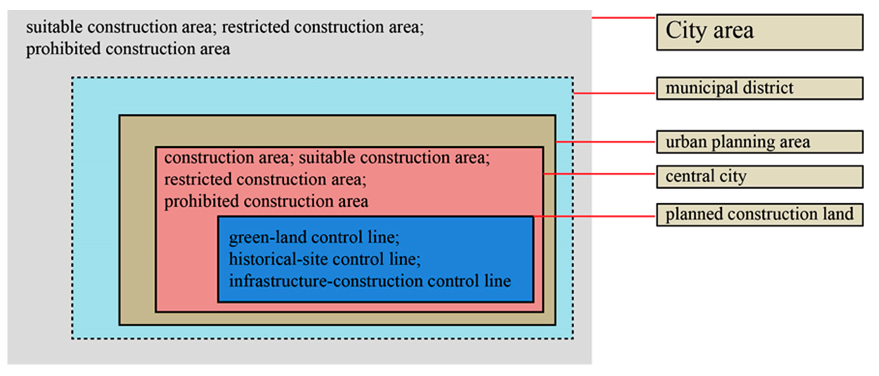
2.2. Ministry of Housing and Urban–Rural Development (MHURD)-Led Urban and Rural Planning System

The establishment of China’s urban planning started during the First Five-year Plan period. In 1952, to support 156 Soviet Union-assisted key construction projects, China’s central government established the Department of Construction Engineering, under which the General Bureau for Urban Construction was established to take responsibility for formulating urban planning. Thus, urban planning represented the continuation and spatial implementation of national economic planning. During this period, initial planning for more than 150 cities across China and detailed planning for some factory yards and residential areas were completed. For historical reasons, the number and research capacity of urban planning management organizations were largely reduced after 1960, and urban planning entered a state of stagnation. A modern urban planning system was not truly established until the 1980s. In 1982, China established the Ministry of Urban and Rural Construction and Environmental Protection. In 1988, China officially established the Ministry of National Construction and promulgated the Urban Planning Law of the People’s Republic of China (hereinafter the Urban Planning Law). The Ministry of Housing and Urban–Rural Development-led Urban Planning was gradually institutionalized. China’s urban planning is often divided into two stages: the master planning stage and the detailed planning stage. Since the 1980s, China has implemented an administrative zoning system in which cities control counties. Cities have become “geographical administrative regions” in which urban and rural areas are governed together (Figure 1). Corresponding to this type of administrative zoning mode, the Urban Planning Law first established a “central city construction planning+urban system planning for the city (county) area” urban master planning (UMP) structure in the form of legislation in 1990. Because of the long-term impact of the urban–rural dual structure, the UMP focused on the central city region, and planning and management were limited within the range of the planning area or within the range of the planned construction land. Urban system planning for the city/county area became auxiliary planning and provided relatively poor guidance for areas outside the central city region [40]. The new Urban Planning Formulation Method implemented in 2006 first established requirements for master planning and spatial regulation for urban and rural areas within the city area. The control requirements for restricted and prohibited construction zones were made mandatory in the planning of the urban system. At the same time, urban planning also expanded its perspective to include vigilance against the spread of construction land and the control of ecological space. Non-construction land planning represented by the “basic ecological control line” in Shenzhen and the “restricted construction zone” in Beijing has been actively carried out. In 2008, the Urban and Rural Planning Law of the People’s Republic of China (hereinafter referred to as the Urban and Rural Planning Law) was promulgated, which is the first law in China to be titled Planning Law. The Urban and Rural Planning Law integrates urban and rural space into a unified system, realizing the transformation from an “urban planning system” to an “urban and rural planning system”. During this period, urban master planning began to constantly burden itself. On the one hand, land use layout planning was pushed from the central urban area to the wide area. Some large cities with strong governance capabilities, such as Beijing, Shanghai, Guangzhou, Shenzhen, Xiamen, Wuhan, etc., expanded the planning area of the urban master plan to the city area, which greatly increases the groundwork, coordination content, and preparation period of the master plan [41,42,43,44]. On the other hand, the form of urban planning gradually jumps out of simple land use planning or morphological planning, strengthens strategic research at the macro level, and develops into “flexible spatial planning”, which is increasingly manifested as comprehensive public policies. China promulgated its first national urban system plan in 2007, which has largely accumulated useful experience for urban planning to implement spatial governance at the macro level. After 2000, urban system planning was innovated to include cross-city urban agglomeration, metropolitan area (district) planning, and other sub-regional urban system planning concepts that have been effectively applied.
In addition to preparing master plans for cities, the urban–rural planning system of the Ministry of Housing and Urban–Rural Development also includes county, town, and village plans. When defining the connotation of urban planning, China’s Urban Planning Law in 1990 included both towns and incorporated cities in the same category of urban planning, which fully reflected the original intention of the housing and construction department to carry out urban planning based on “city-type administrative district”. In order to coordinate the economic development of the county, the “county and city master plan” sets up a planning framework similar to the city master plan, covering two levels of “county resident town planning” and “district regional planning” in terms of content. The Urban and Rural Planning Law brought “township planning” and “village planning” into the unified urban and rural planning system by legislative means. Because of the long-term use of the urban planning formulation mode, China’s traditional town planning experienced almost all of the problems of the urban planning operation process and followed an evolutionary path similar to urban planning (from “a corner” to “the whole area”).
The urban and rural planning system led by the Ministry of Housing and Urban–Rural Development also includes independent urban system planning with the nature of regional planning. In 1978, China established an economic reform path, the implementation of which resulted in rapid urban development. To avoid “discussing a city solely based on this city” and allocating national key construction projects in an orderly manner, urban system planning was innovatively used. Initially, the main task of urban system planning was to determine the nature and scale of cities. The basic content of urban system planning included “three structures and one network”. China promulgated its first national urban system plan in 2007, which has largely accumulated useful experience for urban planning to implement spatial governance at the macro level. After 2000, urban system planning has been innovated to include cross-city urban agglomeration, metropolitan area (district) planning, and other sub-regional urban system planning concepts that have been effectively applied (e.g., the Spatial Coordination Planning for the City Agglomeration in the Pearl River Delta Region (2004–2020) and the Regional Planning for the Changsha–Zhuzhou–Xiangtan City Agglomeration (2003–2020)).
In addition to drawing up macro master plans, China’s urban and rural planning also has the category of detailed planning. Regulatory detailed planning (RDP) is the deepening of UMP. In the late 1980s, some cities introduced RDP to adapt to requirements such as paid land sale and diversified development bodies after the reform of the urban land use system, realizing the transition of the approach to detailed planning from the traditional “form design” to “development control” [45]. The “land block indicator+statutory map” RDP became the most direct tool for the government to control and guide urban land use. RDP stipulates the land-use regulation policy within the city and [46], to a certain extent, can be viewed as the extension of China’s land-use regulation system for urban construction land and the process through which the local government confers land development rights. This development permission system played an important role in controlling urban development density, eliminating improper land use, balancing the economic value of space, and exercising the governmental function of providing public products. However, since the late 1980s, the system of paid use of state-owned land, the market economy system, and the tax-sharing system have been successively established in China. Urban space and land have become important assets that attract the local government’s attention. The city government’s economic considerations have a strong guiding effect on land use planning and conditions. The frequent revision of RDP and the failure of the system have already provoked deep thoughts. The difference between the prospect of RDP determined by the local government and the UMP scheme (or land use master planning (LUMP)) established by either the central government or the higher-level department responsible for planning continues to await a solution.

2.3. Original Ministry of Land and Resources (MLR)-Led Land Use Master Planning

Because of its national conditions (a large population but limited land resources) and special publicly owned land system, China established the State Bureau of Land Administration directly under the State Council in 1986 to centrally manage and macroscopically regulate and control national land resources. The Land Management Law of the People’s Republic of China was later promulgated; that law legally established the LUMP’s task for the first time. At the beginning of LUMP’s implementation, it was clarified that LUMP’s planning area was separate from that of urban planning, and it was also stressed that “urban planning and LUMP should be coordinated and urban planning should be the dominant type of planning within the urban planning area and land use should be consistent with urban planning”. At that time, LUMP primarily attempted to protect cultivated land at the periphery of the urban planning area. In addition, the classification of land use in LUMP tended to reflect the classification of farmland. The boundary between LUMP and urban planning was relatively clear [47]. Why, then, was the LUMP system, which seemed to have a reasonable, separate role and clear boundary from urban planning, not well operated? The root cause of the problem might be that the urban planning area, the potential binding boundary, was dynamic and preferred development. In addition, the Original Ministry of Land and Resources (OMLR) left the authority for planning approval to local governments. Naturally, local governments would try everything in their power to increase the amount of construction land that they could operate. For example, an entire piece of construction land was obtained by “breaking the whole into parts” and requiring multiple review and approval processes. Overall, the first round of LUMP formulated in 1987 was not implemented very well.
Confronted by a dire situation in which the population continued to increase and farmland gradually decreased, the State Council of China conducted an institutional reform and decided to establish the OMLR in March 1998. In addition, the State Council of China comprehensively revised the Land Management Law. This revision laid the groundwork for the current Land Management Law of China. The Land Management Law stipulated the strictest “farmland protection system” and became the basis for formulating and implementing LUMP. During this round of LUMP, China’s central government began to recover the authority to approve LUMP from local governments and restricted that authority to governments above the provincial level. LUMP became more rigid and binding in terms of the form of management and control.
On the one hand, the control of the key indicators was a major characteristic of this round of LUMP. Centering on the dynamic balance of the total area of farmland and control of the total area of construction land, the main indicators were decomposed from top to bottom, level by level, at the national, provincial, city, county, and town (township) levels [48], thereby significantly improving the rigidity of this round of LUMP. On the other hand, land use management and control was another major characteristic of this round of LUMP. Planning at the national and provincial levels focused on guiding land use policy and decomposing the main indicators, and only planning below the county level focused on land use zoning and the formulation of specific planning drawings. The red blocks in land use planning drawings represent LUMP’s intention to manage and control urban and rural construction land, thus, allowing the logic of urban planning to arrange construction space to truly transform itself into “planning-bound planning”. However, without a sufficient estimate of the urban development factor and development trend, this fine-grained management and control led to constant breaking and revising of planning to ensure economic development, significantly affecting the serious nature of planning while increasing the cost of planning.
The 1998 version of LUMP played a pivotal role in protecting farmland and ensuring development but simultaneously was confronted by a series of challenges. The third round of LUMP, which began in 2006, was relatively significantly improved. First, LUMP had already classified the management and control indicators into binding and anticipatory indicators. This change had a profound impact. The top-to-bottom decomposition of the binding indicators could be viewed as the central government’s responsibility for protecting farmland and the distribution of land development rights for each level of administrative region and determining the bottom line of preserved cultivated land, basic farmland and supplementary cultivated land, the upper limit of the use of cultivated land for non-agricultural construction, and the total area of land used for urban and rural construction in a city/county. This reflected not only local governments’ responsibility for protecting farmland but also the disposition of the opportunities that local governments could obtain for land urbanization across the territorial space. Because China was then experiencing a period of rapid urbanization, the expansion of land used for urban construction was unstoppable. Under the circumstances in which the agricultural population was transformed into a non-agricultural population and the rural population continued to decrease, the area of land used for village construction increased. Large areas of quality, cultivated land were occupied, and potential land resources could not be revitalized. The “total area of land used for urban and rural construction” became an important binding indicator. As mentioned previously, the “URMP” with “urban and rural coordination” as the main theme and the entire urban and rural area as the planning object began to be implemented in many locations during this period. “Coordinating land use” was only one of the factors that affected how URMP regulated and controlled the spatial layout. In addition, the layout of land used for urban and rural construction was primarily based on independently conducted (MHURD-led) construction planning. The construction layout under the decentralized decision-making process further increased the likelihood of breaking the “responsibility boundary”.
Second, LUMP continued to use the land use management and control approach used in the second round of LUMP. Certainly, the OMLR realized that it was difficult to fully manage and control the expansion of construction land through fine control of land use zoning. Therefore, during this round of planning, the OMLR further expanded its approach to space management and control, thereby forming a “four areas, three boundaries” (“four areas, three boundaries” refers to constructive expansion permitted zone(CEPeZ), constructive expansion conditionally-permitted zone(CECPZ), constructive expansion restricted zone(CERZ), constructive expansion prohibited zone(CEPrZ), boundary of the constructive expansion permitted zone, boundary of the constructive expansion limit, and boundary of the constructive expansion prohibited zone) management and control system for construction land. Within the expanded boundary, an application for using land for construction could be submitted according to the procedure if the rules were followed and the scale of land used in the constructive expansion permitted zone was decreased after review, leaving a certain flexibility in the implementation of the planning. Nevertheless, new problems ensued. How much should be reserved? Where should the reservations be made to provide sufficient flexibility? Because accurate measurements could not be obtained when establishing the urban scale and boundary in the planning, accurate measurements of the amount, the location, and the shape of the boundary of this type of reserved extra space could also not be taken. Therefore, in terms of the spatial layout of urban construction land, the conflicts between the UMP and LUMP remained unresolved. In fact, in addition to the problems in coordination with the UMP, areas of land used for non-construction purposes (such as forestland areas and ecological safety control areas) in the LUMP were managed and planned by different departments. When addressing the comprehensive problem of attempting to adjust land used for different purposes, the LUMP, because of the specialty of land management departments, faced challenges caused by various departments’ conflicts of interest.

2.4. Ministry of Environmental Protection (MEP)-Led Ecological/Environmental Planning System

China has a relatively short history of implementing modern ecological and environmental planning. In 1982, China officially established the Bureau for Environmental Protection, which, in 1988, was upgraded to the State General Bureau for Environmental Protection, forming an environmental protection and management system vertically from the national level to the provincial level, the district (city) level, and the county (city) level [49]. The MEP’s traditional types of planning primarily cover two systems: “planning” and “zoning”. (1) The MEP’s traditional responsibility was to formulate national-level to city/county-level five-year planning and special planning for environmental protection. Planning for environmental protection, as special planning for national economy and social development planning, focused on targeting control of environmental quality and formulating schemes and measures for environmental protection. Relatively less frequently, it involved the spatial layout. (2) The zoning system included both environmental function zoning and ecological function zoning. Thus far, the MEP has implemented pilot environmental function zoning projects at various levels (national, regional, provincial, and city/county). Because of the MEP’s limitations and lack of legal status, this type of zoning scheme was generally set based on the spatial pattern of other types of planning, and thus, prepositional control could not be assumed. In addition, the MEP completed provincial-level ecological function zoning between 2002 and 2004. Furthermore, the MEP issued the National Ecological Function Zoning, establishing a zoning scheme that covered China’s entire territorial space and confirming important ecological function zones such as biodiversity protection zones, water resource conservation zones, soil conservation zones, wind-breaking and sand-fixation zones, and flood diversion and storage zones. The concept of development-restricted areas (i.e., the national key ecological function zones) was proposed in the National Major Function-oriented Zoning issued during that same period [50]. Although the expressions are different, these areas named “ecological functional zones” are usually divided into counties as a whole, mainly playing the role of providing important ecological products for the country and ensuring national and regional ecological security; this later became the basis for determining ecological protection lines (EPLs).
After 2012, the need to respond to climate change became a strong global consensus. Eco-environmental protection in China is confronted by a new situation and system background. Planning for eco-environmental protection has historically been the subject of high expectations. Some new directions have emerged. On the one hand, the MEP has strengthened the establishment of a system for protecting ecological space and managing and controlling EPLs. Following the inclusion of “ecological progress” in the “five in one” master layout during the 18th National Congress of the Communist Party of China, the new Environmental Protection Law came into effect in 2015. That law increased the requirements for ecological protection and, for the first time, stipulated “the determination of EPLs” in the form of legal clauses [51]. The EPLs refer to the areas in the national natural ecosystem that have special important ecological functions or are ecologically sensitive and fragile that must be strictly protected. It is the specific boundary for the bottom-line constraint and zoning control of ecological space, which is different from the “key ecological function zones” defined in the above zoning, a large-scale zoning or policy guidance zone. On the other hand, the MEP has also strengthened prepositional management and control of environmental space. In 2012, the MEP issued the Notice on the Implementation of the Pilot Projects of the Formulation of Master Planning for Urban Environment and guidelines on related techniques. The MEP conducted a pilot project in 24 cities (including Fuzhou, Guangzhou, Guiyang, etc.) in two batches. The core of the master planning for the urban environment included setting goals and indicators, environmental quality control lines, EPLs, controlling the carrying capacity for environment and resources, etc. In addition to the EPLs (with spatial meaning), “environment control lines” were the core of the Urban Environment Master Planning (UEMP) and the MEP’s innovative exploration of the management and control of environmental factors. The “environment control lines” attempted to establish prepositional requirements for the hierarchical spatial management and control of environmental factors (water, atmosphere, etc.) for economic development and urban construction.
Since 2017, the environmental protection department has integrated the above-mentioned EPLs and UEMP and other work, established a “three lines one permit” ecological environment zoning management and control system, namely ecological protection red line, environmental quality bottom line, resource utilization online, and ecological environment access list, and carried out the compilation and research work at the provincial and municipal levels [52]. However, under China’s “blocky” government management system, the systematic regulation of “ecology”, “environment”, and “resources” by professional environmental protection departments is bound to be insufficient. In addition to environmental protection departments, administrative departments such as forestry, land, agriculture, housing construction, and water conservancy also assume special natural ecological space supervision functions. For example, the spatial management and control boundaries of national wetland parks, nature reserves, national forest parks, and other nature reserves are generally delimited by the forestry department, while the spatial management of national geoparks, basic grasslands, and scenic spots are, respectively, under the authority of the former Ministry of Land and Resources, Ministry of Agriculture, and Ministry of Housing and Urban–Rural Development. The ecological redlines drawn by the environmental protection department reflect the intention of the environmental protection department to control the ecological space, and it is difficult to coordinate the protection boundaries planned by other departments. In addition, the original intention of policy design is to carry out the idea of combining “target control” and “spatial control”. Although the concept of “environmental control requires space landing” in “three lines one permit” is relatively advanced, the theoretical construction of environmental spatial governance is still lagging behind, especially since the control scale of different environmental elements is different, and some environmental factors have limited significance in microscale control [53].

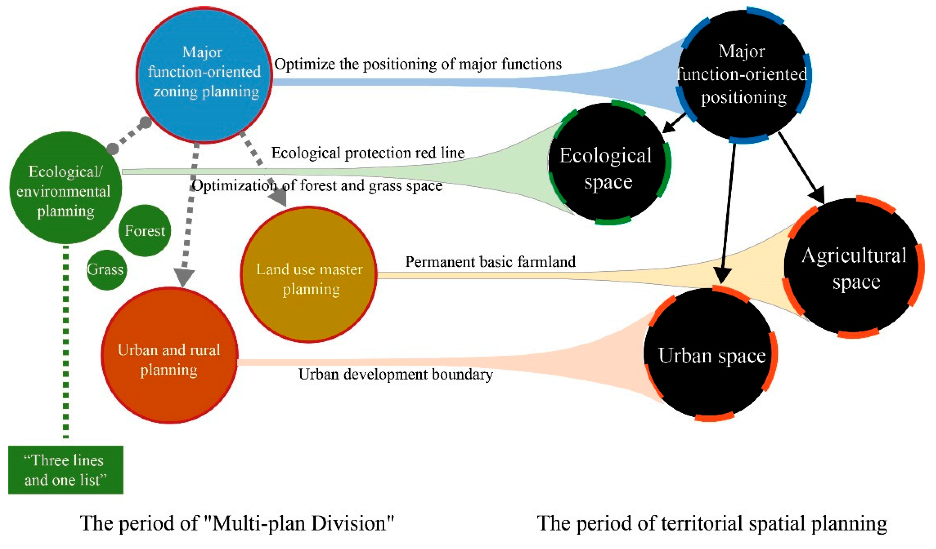
2.5. Moving towards Multi Planning and Integration: Building a Brand New Territorial Spatial Planning

With the development of the People’s Republic of China, for more than half a century, the spatial planning led by the department has continuously inherited and innovated the form of planning in the process of coping with specific national conditions and practical problems in development, and the types of spatial planning in China have gradually changed from absence to overlap [54,55]. As can be seen from the above, before the reform and opening up, planning was mainly led by two departments, the Planning Commission and the Construction Commission, and the development plan under the planning system and urban planning presented a clear division of labor between “project directory—spatial deployment”. The lack of macro-regional planning and detailed construction planning resulted in a long-term lack of effective guidance for urban and rural spatial development. In the first three decades after the reform and opening up, China’s planning and management institutions with departmental characteristics have successively established and separately constructed planning systems, further enriching the types of spatial planning. Although China’s national-scale spatial planning and large-scale regional planning have been absent for a long period, the innovation of urban system planning has made up for the gaps in the strategic spatial structure planning at the provincial level. The establishment of “legal-non-statutory planning” and general land use planning in the field of urban planning has greatly enriched the types of spatial planning at the city and county levels. Since 2006, planning systems led by departments have placed spatial content at the core of management and control. Compared with the absence of spatial planning at the national level before 2007, the coordination dilemma of multi-regulation division and planning has become a prominent problem [56]. The contradictions in the rules in the same space have profoundly affected the efficiency of space governance and development and protection. Under such circumstances, in 2014, the National Development and Reform Commission, the former Ministry of Land and Resources, the Ministry of Housing and Urban–Rural Development, and the Ministry of Environmental Protection jointly launched a pilot program of “integration of multiple planning” in 28 counties and cities, promoting economic and social development planning, urban and rural planning, land use planning, and ecological and environmental protection planning at that time. In addition to the selected pilot areas, many other counties, cities, and provinces have also invested in the exploration of “multi-plan integration” spatial planning reform. In 2018, the natural resources management agency ushered in a major reform in the history of the People’s Republic of China—the Ministry of Natural Resources of the People’s Republic of China was formally established. The Ministry of Natural Resources (MNR) is mainly responsible for the ownership of natural resources such as land, minerals, forests, grasslands, wetlands, water, and oceans owned by the whole people and the control of all land and space uses. This provides an institutional basis for responding to the coordination dilemma of natural resource conservation (multi-management of nature reserves) and spatial planning under the original decentralized governance and forms an important institutional guarantee for the establishment of a unified spatial planning system. In May 2019, the CPC Central Committee and The State Council issued the Opinions on Establishing and Supervising the Implementation of a Territorial Spatial Planning System, proposing to integrate functional zoning planning, land use planning, urban and rural planning, and other spatial plans into a unified territorial spatial planning, realizing the integration of multiple plans—territorial spatial planning that is parallel with development planning. Territorial spatial planning has established five levels: national, provincial, municipal, county-level, and township level, and there are three categories: master planning, detailed planning, and special planning, and the master planning of land and space is the core of this system.
The new master plan for territorial space is a form of inheritance and innovation based on the original planning (Figure 2). First, territorial spatial planning inherits the regional functional positioning of the major functional zone planning. The basic functional types of county-level administrative districts are determined in the planning (including the three basic types of “urbanization area”, “key ecological functional area”, and “main agricultural product producing area”). Second, the original urban master planning to regulate the spatial layout of urban and rural construction land and the permit of urban and rural construction was incorporated into the territorial spatial planning as a whole, and the innovative concept of delineating the “urban development boundary” was proposed in the territorial spatial planning. The territorial spatial planning also incorporates the “ecological protection red line” originally established by the environmental protection department in the preparation of the “three lines one permit” and the spatial boundaries of cultivated land and permanent basic farmland protection in the master land use plan, and finally forms a “three-line” management and control system including ecological protection red line, permanent basic farmland, and urban development boundary. Third, territorial spatial planning inherits the scale constraint indicators such as the master land use planning of the amount of cultivated land and the scale of permanent basic farmland and construction land, forming a new binding index system. However, different from previous land use master planning, territorial spatial planning begins to pay attention to the spatial arrangement at the provincial level, especially to the spatial placement of national nature reserves. Finally, territorial spatial planning also inherits the idea of land use control in master land use planning and urban planning, extends use control to natural ecological space, and implements land space use control in the whole region [57,58]. The ecological space and agricultural space in territorial space usually have significant external benefits. The implementation of use control is a policy remedy to make up for the failure of market allocation of resources. The aforementioned three control lines and their space control areas constitute an important basis for the implementation of territorial space use control. For example, as a guaranteed area for national food security and important agricultural products, basic farmland is easily repurposed due to the underestimation of existing uses and potentially high returns in actual land use activities. Therefore, it is an important approach to classify relatively concentrated areas of permanent basic farmland as farmland protection areas. For another example, although ecological space, as the carrier of important ecological products, has a high comfort value, it is easy to underestimate and occupy land value inefficiently due to the lack of an effective path to incorporate into the market price system and realize value. Delineating ecological protection red lines is obviously an effective path. In general, the brand-new territorial spatial planning is no longer a local exploration of the previous spatial planning department to seek the transformation of its own planning methods but a fundamental, systematic, strategic, and coordinated reform task involving China’s territorial spatial planning system and the construction of a beautiful homeland. It has also become a basic tool for the Chinese government to achieve a wide range of goals, such as improving the quality of land space, balancing the needs of conservation and development, creating a more rational land use pattern, establishing a more orderly spatial structure, balancing economic and social development between regions, and coordinating the spatial impact of other sectoral policies [59,60]. China’s spatial planning led by the four government departments in four stages after 1949 (Table 1).

3. Discussion: Several Worth-Exploring Key Issues about China’s Spatial Planning System

(1) Whether to promote spatial planning/policy coordination through “soft” or “hard” modes?
China’s sectoral spatial planning has long promoted collaboration between planning departments through informal communication without touching the original sectoral planning pattern. However, in practice, due to the lack of clear coordination mechanisms and legal regulations, the tension between multi-plan and separate governance was increasing [61]. China eventually chose to achieve the unity of multi-sectoral spatial planning through institutional reform, which was a “hard” mode. As a current supra-sectoral integrated plan, territorial spatial planning is mainly coordinated by specialized natural resources authorities, and its ability to coordinate sectoral policies still has limitations. There is also the tricky question of how to harmonize territorial spatial planning with another big planning series—development planning, which often has sizeable fiscal budgets and attracts considerable political attention. This is a worldwide problem. In countries that fall under integrated/integrated planning (e.g., Denmark, Netherlands, Germany), although coordination and integration are at the heart of their planning, there are also problems with inadequate coordination. In the future, “soft” modes, including the use of communication and consensus-building where possible, may still be necessary. In Western countries, urban planning has experienced significant theoretical and corresponding research paradigm transformation, and planning theory has gradually shifted from focusing on the perfection and rationality of planning results to paying more attention to the fairness and rationality of planning procedures [62]. In contrast, spatial issues and the formulation of scientific spatial planning goals and programs have always been the focus of China’s spatial planning. This has long been considered an exclusive responsibility of the government, but now it requires public participation and consultation, which will challenge the previously closed planning system. However, when it comes to vertical coordination of planning, some “hard” modes may require more attention. Here, the UK has provided valuable lessons for reference, such as the county government reform and decentralization promoted in the 1980s. Whether this experience can be used to promote planning reform at the municipal level in China needs to be discussed in the context of specific political and administrative division systems. What is certain, however, is that China’s current vertical planning system has too many levels—as many as five levels or more (if cross-administrative spatial planning is included)—compared to countries with sound planning systems, which greatly affects the efficiency of planning.
(2) How to balance the two needs of protecting the environment and enhancing geographical competitiveness by considering legality and efficiency?
The implementation of the whole “space use control” and top-down “index control” is an important feature of China’s territorial spatial planning, which makes territorial spatial planning a strong and rigid statutory plan. This is also significantly different from the planning systems of many European countries, which mainly carry out land-use planning or physical planning in municipal planning at the bottom of the spatial planning system. This round of reform of China’s territorial spatial planning reflects, to some extent, the importance attached to ecological protection under the vision of ecological civilization. However, in the face of the need for post-COVID-19 economic recovery and the impact of the global economic slowdown, how to build a resilient geographical structure to provide local governments with a spatial vision in a global and regional competitive environment may be another major mission faced by China’s territorial spatial planning. China has innovatively used informal planning, such as strategic planning and urban–rural integrated planning in its original urban planning practice, which is very similar to Germany’s “urban development planning” and “urban construction framework planning” at the local level, providing flexible planning and diversified choices for urban governance. Informal planning is particularly attractive when formal planning processes no longer deliver the desired planning performance [63]. However, in the construction of territorial spatial planning, these non-statutory plans have disappeared from the list of planning systems. In addition, in recent years, an innovative practice similar to “transferable development right” as a supplementary mechanism for the allocation of land and spatial resources, this tradable right characterized by “urban and rural construction land index trading”, provides certain ideas for solving market-oriented land use demand. China has also piloted policies such as wetland banks and forest coverage index trading, which are widely believed to have injected elasticity into rigid land management systems. However, further policy pilots need to be clarified in relevant aspects or in the form of institutions and regulations.
(3) Should the framework “main function area” or the refined “space use area” be the focus of the territorial spatial layout?
Spatial zoning has an obvious scale effect. The smaller the spatial scale, the more obvious the homogeneity within the partition and the more conducive to specific spatial control. Conversely, the larger the spatial scale, the richer the regional information of the zoning load, and the greater the versatility of the region within the zoning, and the zoning becomes a kind of major function-oriented zoning and policy guidance area. The zoning in the territorial spatial planning of cities and counties has the characteristics of the above-mentioned small-scale zoning and provides a basis for the refined spatial governance of the whole area through the specific spatial use zoning that can be implemented. The zoning in the macro-level territorial spatial planning has the characteristics of the above-mentioned large-scale zoning, and the planning zoning mainly highlights the differences in the major function-oriented zones. This differentiated spatial strategy composed of major function-oriented zones is increasingly adapted to the governance needs of contemporary territorial development protection and regional development. In this spatial planning reform, the major function-oriented zoning was incorporated into the provincial–territorial spatial planning as a geographical positioning. However, how to pass on the city, county, and township planning as an innovative system with high hopes is bothering Chinese planners, and even in grassroots territorial spatial planning, they seem to have no idea where the major function-oriented zonings went. Based on this, some local pilots and technical documents began to require that the major function-oriented zones be refined to townships. That may be both unnecessary and difficult to achieve. Since the initial delineation of the major function-oriented zones with counties as units faced the challenge of localism, can this problem be avoided by determining the major function-oriented zones at the township level? In addition, the important policy significance of determining the major function-oriented zone to the county is to provide a basis for the central financial transfer payment; while further refinement is of no substantial value, perhaps local planning to focus on spatial use zoning is a more pragmatic choice. This means that the top-down spatial layout system of future territorial spatial planning is not the transmission from “major function-oriented” to “major function-oriented” and it is more practical to establish a transmission mechanism from “major function-oriented” to “space use zoning”, although such transmission mechanism and top-down policy community have yet to be constructed.

4. Conclusions

First, China’s spatial planning has long presented a pattern of separate management by multiple departments, such as development and reform, construction, land, and environmental protection, whether it is the Five-year Plan accompanying the development of the People’s Republic of China for more than half a century, the urban planning that has experienced more than 60 years of spatial governance history in New China, or the land use plan that has gradually strengthened the binding force of planning in the past 30 years. Ecological environment planning has only begun to develop rapidly in recent years and has begun to involve the field of spatial planning. The emergence and development of planning in various departments have evolved, as have their value contributions. Today, China’s territorial space planning, which is produced under the iterative needs of ecological civilization construction and high-quality development, is providing a Chinese solution for the comprehensive governance of the whole space. All kinds of spatial planning are necessary spatial governance tools for specific national conditions and problems in development at specific stages.
Second, in the long-term evolution process, all departments are gradually establishing, inheriting, and reforming their own planning systems and constantly strengthening the allocation and control of space resources. Before the reform and opening up, China’s spatial planning had been absent for a long time. In the first three decades of the implementation of the reform and opening up policy, spatial planning also achieved its own growth under the guidance of growthism, which made the coordination dilemma of multi-plan division and governance and planning become a prominent problem. The spatial planning reform in the past decade has pushed China’s spatial planning system from the stage of multi-plan division and governance to a new stage of multiple rules and regulations in one. Like the spatial planning of many countries in the world, after years of development and reform of China’s spatial planning, comprehensive spatial planning that is parallel with development planning has finally been formed.
Third, after years of spatial planning development and reform, China has finally formed a comprehensive spatial planning system. It inherits the core content of “space use control” from the original planning system and adopts spatial use zoning equivalent to the fineness of land use planning at the city and county level, and implements control lines such as ecological protection red lines, permanent basic farmland red lines, and urban development boundaries to specific plots. The implementation of “indicator control” is another core feature of territorial spatial planning. Scale and structural indicators related to development, utilization, and protection are set up in the territorial spatial planning, which is transmitted step by step in the preparation of the plan as constraints for the preparation of the plan in the lower level. Space use control and indicator control have become the decision-making basis for the current allocation of territorial spatial resources.

Author Contributions

Conceptualization, Y.Z. (Yongjiao Zhang) and X.M.; software, X.M. and Y.Z. (Yongnian Zhang); writing—original draft, Y.Z. (Yongjiao Zhang) and Y.Z. (Yongnian Zhang); visualization, Y.Z. (Yongnian Zhang); Writing—review and editing, Y.Z. (Yongjiao Zhang) and Y.Z. (Yongnian Zhang); supervision, Y.Z. (Yongnian Zhang); funding acquisition, Y.Z. (Yongjiao Zhang) and Y.Z. (Yongnian Zhang). All authors have read and agreed to the published version of the manuscript.

Funding

This research was supported by The Second Tibetan Plateau Scientific Expedition and Research Program (STEP) (grant number 2019QZKK1005) and the National Natural Science Foundation of China (grant number 41701170).

Data Availability Statement

Not applicable.

Conflicts of Interest

The authors declare no conflict of interest.

References

  1. Medeiros, E. Spatial Planning, Territorial Development, and Territorial Impact Assessment. J. Plan. Lit. 2019, 34, 171–182. [Google Scholar] [CrossRef]
  2. Persson, C. Perform or conform? Looking for the strategic in municipal spatial planning in Sweden. Eur. Plan. Stud. 2020, 28, 1183–1199. [Google Scholar] [CrossRef]
  3. Trkulja, S.; Tosic, B.; Zivanovic, Z. Serbian Spatial Planning among Styles of Spatial Planning in Europe. Eur. Plan. Stud. 2012, 20, 1729–1746. [Google Scholar] [CrossRef]
  4. Priemus, H.; Zonneveld, W. Regional and transnational spatial planning: Problems today, perspectives for the future. Eur. Plan. Stud. 2004, 12, 283–297. [Google Scholar] [CrossRef]
  5. Sun, S. On the Transformation from Urban and Rural Planning to Territory Development Planning. Urban Plan. Forum 2020, 11–17. [Google Scholar] [CrossRef]
  6. Prevost, A.; Robert, S. Local spatial planning practices in four French Mediterranean coastal territories under pressure. Land Use Policy 2016, 56, 68–80. [Google Scholar] [CrossRef]
  7. Lazzarini, L. The role of planning in shaping better urban-rural relationships in Bristol City Region. Land Use Policy 2018, 71, 311–319. [Google Scholar] [CrossRef]
  8. Sykes, O. The importance of context and comparison in the study of European Spatial Planning. Eur. Plan. Stud. 2008, 16, 537–555. [Google Scholar] [CrossRef]
  9. Roodbol-Mekkes, P.H.; van den Brink, A. Rescaling spatial planning: Spatial planning reforms in Denmark, England, and the Netherlands. Environ. Plan. C-Gov. Policy 2015, 33, 184–198. [Google Scholar] [CrossRef]
  10. European regional/spatial planning charter (Extracts). Environ. Policy Law 1983, 11, 82–83. [CrossRef]
  11. Chigudu, A.; Chirisa, I. The quest for a sustainable spatial planning framework in Zimbabwe and Zambia. Land Use Policy 2020, 92, 104442. [Google Scholar] [CrossRef]
  12. Zhang, J.; Wang, Q.; Xia, Y.P.; Furuya, K. Knowledge Map of Spatial Planning and Sustainable Development: A Visual Analysis Using CiteSpace. Land 2022, 11, 331. [Google Scholar] [CrossRef]
  13. Hersperger, A.M.; Oliveira, E.; Pagliarin, S.; Palka, G.; Verburg, P.; Bolliger, J.; Gradinaru, S. Urban land-use change: The role of strategic spatial planning. Glob. Environ. Chang. 2018, 51, 32–42. [Google Scholar] [CrossRef]
  14. Cullingworth, B.; Nadin, V. Town and Country Planning in the UK, 14th ed.; Routledge Press: London, UK; New York, NY, USA, 2006. [Google Scholar]
  15. Frank, T.; Strauss, W.C. Integrierte stadtentwicklung in deutschen kommunen:eine standortbestimmung. Inf. Raumentwickl. 2010, 4, 253–256. [Google Scholar]
  16. Dangschat, J.S.; Frey, O.; Hamedinger, A. Strategieorientierte Planung im kooperativen Staat. In Strategieorientierte Planung im Kooperativen Staat; Hamedinger, A., Frey, O., Dangschat, J.S., Breitfuss, A., Eds.; VS Verlag für Sozialwissenschaften: Wiesbaden, Germany, 2008; pp. 352–367. [Google Scholar] [CrossRef]
  17. Mario, R.; Panagiotis, G.; Hans, B. Spatial Planning Systems and Practices in Europe (A Comparative Perspective on Continuity and Changes); Routledge: London, UK, 2014. [Google Scholar] [CrossRef]
  18. Wu, Y.; Ren, Y.; Xu, Z. Market Allocation of Land Factors under Territorial Space Planning System: Theory, Mechanisms and Modes. China Land Sci. 2023, 37, 28–37. [Google Scholar]
  19. CEC-Commission of the European Communities. The EU Compendium of Spatial Planning Systems and Policies; Office for Official Publications of the European Communities: Luxembourg, 1997. [Google Scholar]
  20. Yang, D. Reconstructing sustainable spatial planning system: Innovations and relevant debates of the UK government since 2010. City Plan. Rev. 2016, 40, 91–99. [Google Scholar]
  21. Chao, L.; Guoen, W.; Liangwen, S. From Land Use Planning to Spatial Planning: The Evolution of Planning System in the UK. Urban Plan. Int. 2017, 32, 90–97. [Google Scholar]
  22. Boddy, M.; Hickman, H. “Between a Rock and a Hard Place”: Planning Reform, Localism and the Role of the Planning Inspectorate in England. Plan. Theory Pract. 2018, 19, 198–217. [Google Scholar] [CrossRef]
  23. Liu, Y.S.; Zhou, Y. Territory spatial planning and national governance system in China. Land Use Policy 2021, 102, 105288. [Google Scholar] [CrossRef]
  24. Zhou, X.P.; Lu, X.; Lian, H.P.; Chen, Y.C.; Wu, Y.Q. Construction of a Spatial Planning system at city-level: Case study of “integration of multi-planning” in Yulin City, China. Habitat Int. 2017, 65, 32–48. [Google Scholar] [CrossRef]
  25. Chen, M.; Liang, L.; Wang, Z.; Zhang, W.; Yu, J.; Liang, Y. Geographical thoughts on the relationship between ‘Beautiful China’ and land spatial planning. J. Geogr. Sci. 2020, 30, 705–723. [Google Scholar] [CrossRef]
  26. He, J.; Sun, Y. Applying a spatial decision support system to the integrated regional planning of China. Environ. Plan. B-Plan. Des. 2015, 42, 1161–1176. [Google Scholar] [CrossRef]
  27. Wu, Y.; Shan, L.; Zheng, S.; Lai, S.-K.; Xia, B. Regional Planning Reconfiguration in China Based on Inclusiveness: Examining Development and Control Orientation. J. Urban Plan. Dev. 2020, 146, 05020012. [Google Scholar] [CrossRef]
  28. Ye, Y.; LeGates, R.; Qin, B. Coordinated Urban-Rural Development Planning in China the Chengdu Model. J. Am. Plan. Assoc. 2013, 79, 125–137. [Google Scholar] [CrossRef]
  29. Li, L.; Ma, S.; Zheng, Y.; Xiao, X. Integrated regional development: Comparison of urban agglomeration policies in China. Land Use Policy 2022, 114, 105939. [Google Scholar] [CrossRef]
  30. Ng, M.K.; Tang, W.S. The role of planning in the development of Shenzhen, China: Rhetoric and realities. Eurasian Geogr. Econ. 2004, 45, 190–211. [Google Scholar] [CrossRef]
  31. Fan, J.; Sun, W.; Yang, Z.; Fan, P.; Chen, D. Focusing on the major function-oriented zone: A new spatial planning approach and practice in China and its 12th Five-Year Plan. Asia Pac. Viewp. 2012, 53, 86–96. [Google Scholar] [CrossRef]
  32. Chen, D.; Li, O.Z.; Xin, F. Five-year plans, China finance and their consequences. China J. Account. Res. 2017, 10, 189–230. [Google Scholar] [CrossRef]
  33. Fan, C.C. China’s Eleventh Five-Year Plan (2006–2010): From “getting rich first” to “common prosperity”. Eurasian Geogr. Econ. 2006, 47, 708–723. [Google Scholar] [CrossRef]
  34. Shen, H.Y.; Teng, F.; Song, J.P. Evaluation of Spatial Balance of China’s Regional Development. Sustainability 2018, 10, 3314. [Google Scholar] [CrossRef] [Green Version]
  35. Fan, J.; Li, P. The scientific foundation of Major Function Oriented Zoning in China. J. Geogr. Sci. 2009, 19, 515–531. [Google Scholar] [CrossRef]
  36. Fan, J.; Sun, W.; Zhou, K.; Chen, D. Major Function Oriented Zone: New method of spatial regulation for reshaping regional development pattern in China. Chin. Geogr. Sci. 2012, 22, 196–209. [Google Scholar] [CrossRef]
  37. Long, H.; Liu, Y.; Hou, X.; Li, T.; Li, Y. Effects of land use transitions due to rapid urbanization on ecosystem services: Implications for urban planning in the new developing area of China. Habitat Int. 2014, 44, 536–544. [Google Scholar] [CrossRef]
  38. Chen, Y.; Chen, Z.; Xu, G.; Tian, Z. Built-up land efficiency in urban China: Insights from the General Land Use Plan (2006–2020). Habitat Int. 2016, 51, 31–38. [Google Scholar] [CrossRef]
  39. Zhang, C.; Su, Y.; Yang, G.; Chen, D.; Yang, R. Spatial-Temporal Characteristics of Cultivated Land Use Efficiency in Major Function-Oriented Zones: A Case Study of Zhejiang Province, China. Land 2020, 9, 114. [Google Scholar] [CrossRef]
  40. National Urban Planning Practice System Management Committee. Scientific Development View and Urban Planing; China Planning Press: Beijing, China, 2007. [Google Scholar]
  41. Long, Y.; Gu, Y.; Han, H. Spatiotemporal heterogeneity of urban planning implementation effectiveness: Evidence from five urban master plans of Beijing. Landsc. Urban Plan. 2012, 108, 103–111. [Google Scholar] [CrossRef]
  42. He, X.; Zhang, R.; Yuan, X.; Cao, Y.; Zhou, C. The role of planning policy in the evolution of the spatial structure of the Guangzhou metropolitan area in China. Cities 2023, 137, 104284. [Google Scholar] [CrossRef]
  43. Wu, C.; Li, C.; Ouyang, L.; Xiao, H.; Wu, J.; Zhuang, M.; Bi, X.; Li, J.; Wang, C.; Song, C.; et al. Spatiotemporal evolution of urbanization and its implications to urban planning of the megacity, Shanghai, China. Landsc. Ecol. 2023, 38, 1105–1124. [Google Scholar] [CrossRef]
  44. Tian, L.; Shen, T. Evaluation of plan implementation in the transitional China: A case of Guangzhou city master plan. Cities 2011, 28, 11–27. [Google Scholar] [CrossRef]
  45. Zou, B. From strategic planning to immediate construction planning. City Plan. Rev. 2003, 6–12. [Google Scholar]
  46. Lijie, Y. Regulatory Detailed Planning afer the issue of Urban and Rural Planning Law:an analysis of Regulatory Detailed Planning from technology and public policy aspects. City Plan. Rev. 2008, 46–50. [Google Scholar]
  47. Gun, Z.L.; Hu, Y.C.; Zheng, X.Q. Evaluating the effectiveness of land use master plans in built-up land management: A case study of the Jinan Municipality, eastern China. Land Use Policy 2020, 91, 104369. [Google Scholar] [CrossRef]
  48. Shao, Z.; Spit, T.; Jin, Z.; Bakker, M.; Wu, Q. Can the Land Use Master Plan Control Urban Expansion and Protect Farmland in China? A Case Study of Nanjing. Growth Chang. 2018, 49, 512–531. [Google Scholar] [CrossRef]
  49. Xie, Z.H. China’s historical evolution of environmental protection along with the forty years’ reform and opening-up. Environ. Sci. Ecotechnol. 2020, 1, 100001. [Google Scholar] [CrossRef]
  50. Peng, T.; Deng, H.W. Study on the division of main functional regions based on relative carrying capacity of resources: A case study of Guiyang, southwest China. Environ. Dev. Sustain. 2021, 23, 9493–9513. [Google Scholar] [CrossRef]
  51. Hong, W.; Yang, C.; Chen, L.; Zhang, F.; Shen, S.; Guo, R. Ecological control line: A decade of exploration and an innovative path of ecological land management for megacities in China. J. Environ. Manag. 2017, 191, 116–125. [Google Scholar] [CrossRef] [PubMed]
  52. Xu, X.B.; Tan, Y.; Yang, G.S.; Barnett, J. China’s ambitious ecological red lines. Land Use Policy 2018, 79, 447–451. [Google Scholar] [CrossRef]
  53. Wang, Z.; Li, W.; Li, Y.; Qin, C.; Lv, C.; Liu, Y. The “Three Lines One Permit” policy: An integrated environmental regulation in China. Resour. Conserv. Recycl. 2020, 163, 105101. [Google Scholar] [CrossRef]
  54. Hu, Y.; de Roo, G.; Lu, B. ‘Communicative turn’ in Chinese spatial planning? Exploring possibilities in Chinese contexts. Cities 2013, 35, 42–50. [Google Scholar] [CrossRef]
  55. Qiu, Y.; Zhou, A.G.; Li, M.H.; Guo, Y.X.; Cui, H.; Ma, C.M. Territorial spatial usage regulation based on resources endowment and sustainable development: A case of Wuhan, China. J. Clean. Prod. 2023, 385, 135771. [Google Scholar] [CrossRef]
  56. Yang, Z.; Wang, S.; Guo, M.; Tian, J.; Zhang, Y. Spatiotemporal Differentiation of Territorial Space Development Intensity and Its Habitat Quality Response in Northeast China. Land 2021, 10, 573. [Google Scholar] [CrossRef]
  57. Liang, T.; Du, P.; Yang, F.; Su, Y.; Luo, Y.; Wu, Y.; Wen, C. Potential Land-Use Conflicts in the Urban Center of Chongqing Based on the “Production-Living-Ecological Space” Perspective. Land 2022, 11, 1415. [Google Scholar] [CrossRef]
  58. Wang, S.; Qu, Y.; Zhao, W.; Guan, M.; Ping, Z. Evolution and Optimization of Territorial-Space Structure Based on Regional Function Orientation. Land 2022, 11, 505. [Google Scholar] [CrossRef]
  59. Ge, D.; Lu, Y. A strategy of the rural governance for territorial spatial planning in China. J. Geogr. Sci. 2021, 31, 1349–1364. [Google Scholar] [CrossRef]
  60. Xie, B.; Wang, Q.; Huang, B.; Chen, Y.; Yang, J.; Qi, P. Coordinated State Analysis and Differential Regulation of Territorial Spatial Functions in Underdeveloped Regions: A Case Study of Gansu Province, China. Sustainability 2022, 14, 950. [Google Scholar] [CrossRef]
  61. Su, Q.; Zhang, W. Cross-sector collaboration in the process of urban planning reform in China—A case of ‘multiple-plan coordination’ work in Xiamen city, China. J. Asian Public Policy 2022, 1–18. [Google Scholar] [CrossRef]
  62. Healey, P. Collaborative planning: Shaping places in fragmented societies. J. Rural. Stud. 1998, 14, 269–271. [Google Scholar]
  63. Hillier, J. Shadows of Power: An Allegory of Prudence in Land-Use Planning; Routledge: London, UK, 2002. [Google Scholar]
Figure 1. Spatial regulation hierarchy and regulation type of urban master planning.
Buildings 13 01555 g001
Figure 2. Inheritance relationship between territorial spatial planning and original planning.
Buildings 13 01555 g002
Table 1. China’s spatial planning led by the four government departments in four stages after 1949.
PeriodsBefore 19801981–20052006–2018
DepartmentsNDRCMHURDNDRCMHURDMLRMEPNDRC
Subdivided Periods1953–19801953–19601981–19931981–20051981–20071986–200520022006–20182011
Planning TypesFive-Year PlanUrban-PlanningTerritorial-PlanningFive-Year PlanUrban-Planning-SystemLand Use Master PlanningEcological-
Function-Zoning
Five-Year Planning SystemMajor Function-Oriented Zoning Planning
Planning
Levels
Five-Year Master PlanningFive-Year Special PlanningRegional Planning
National-level
Trans-provincial-level
Provincial-level
Inter-city-level
City-level
County-level
Town/
township-level
Periods2006–2018After 2019
DepartmentsMHURDMLRMEPNDRCMNR
Subdivided periods2008–20182006–20182012After 2019After 2019
Planning typesUrban–Rural planning systemland use master planningEcological-
function zoning
Environmental function zoningUrban Environment Master PlanningDevelopment planning systemSpatial planning system
Planning
levels
Urban system planningUrban and rural master planningDetailed urban planningFive-year master planingFive-year special planningRegional planningMaster plan for territorial spaceSpecial planning for territorial spaceDetailed planning for territorial space
National-level
Trans-provincial-level
Provincial- level
Inter-city-level
City-level
County-level
Town/
township-level
Note: The identification symbol “●” indicates that a specific plan/planning exists at the corresponding stage or level. The identification symbol “◎” indicates that a specific plan/planning exists at the corresponding stage or level, but does not involve spatial layout.
Disclaimer/Publisher’s Note: The statements, opinions and data contained in all publications are solely those of the individual author(s) and contributor(s) and not of MDPI and/or the editor(s). MDPI and/or the editor(s) disclaim responsibility for any injury to people or property resulting from any ideas, methods, instructions or products referred to in the content.

