

Adopting Resilience Thinking through Nature-Based Solutions within Urban Planning: A Case Study in the City of València

Abstract
:1. Introduction
1.1. Context and Description of the Case Study
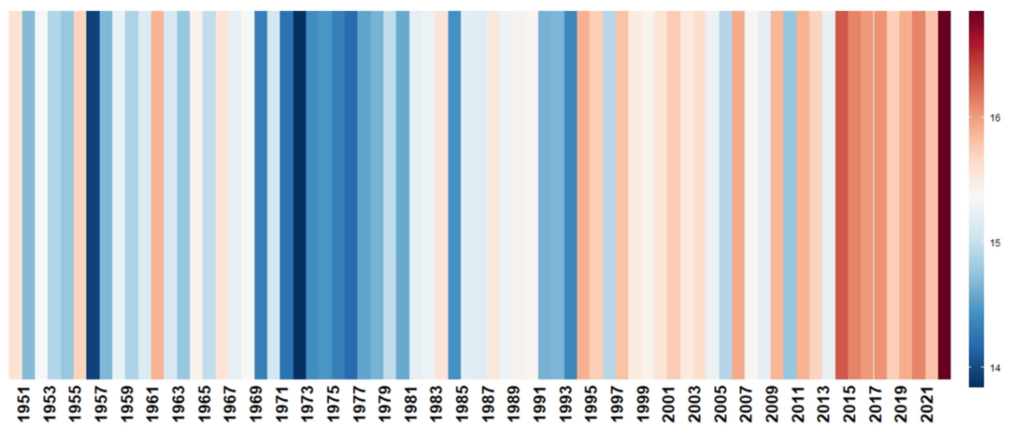
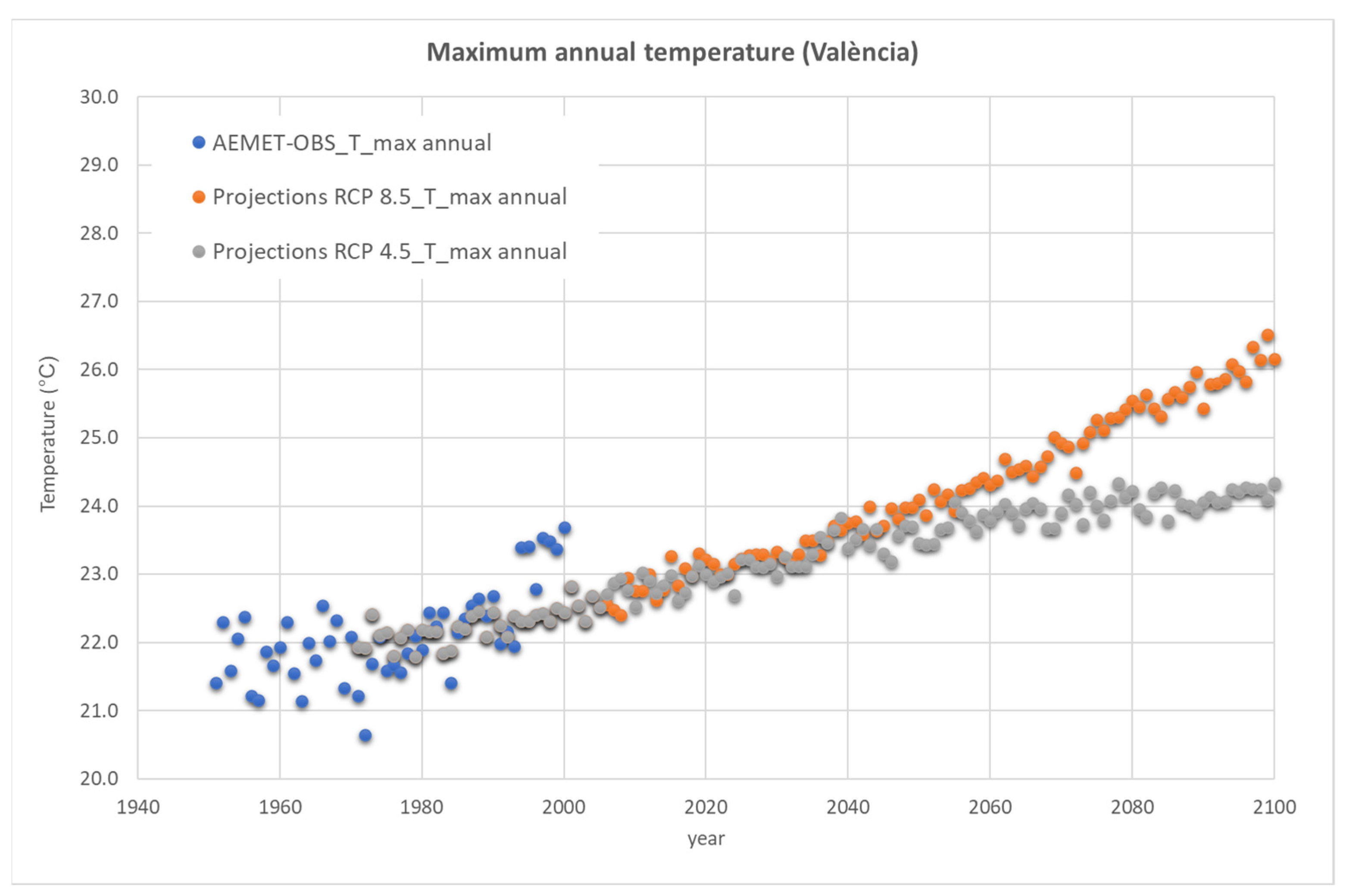
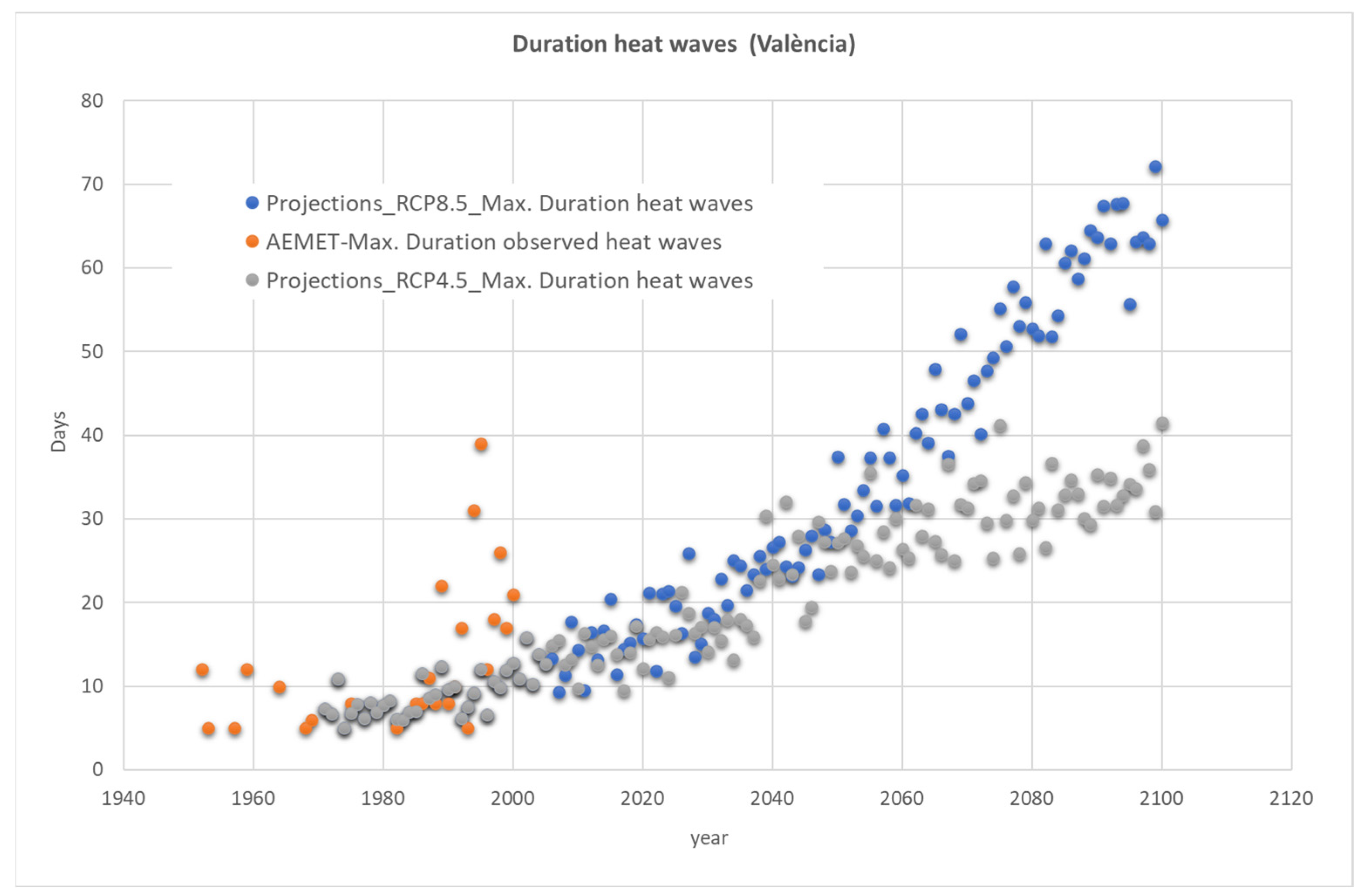
1.2. Climate Change Related Hazards in València
1.3. The Revision of the General Urban Development Plan of València: An Innovative Approach
2. Materials and Methods
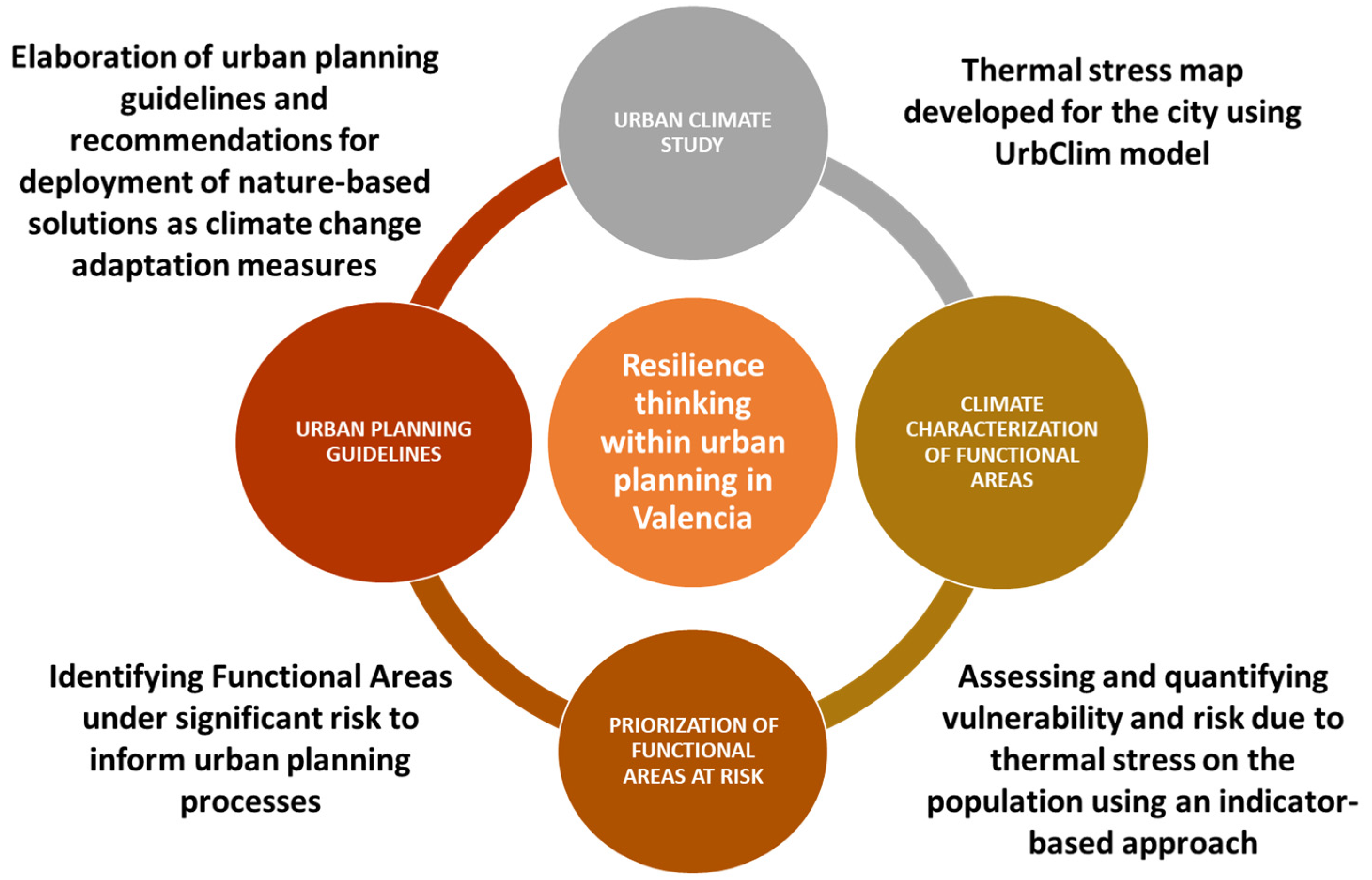
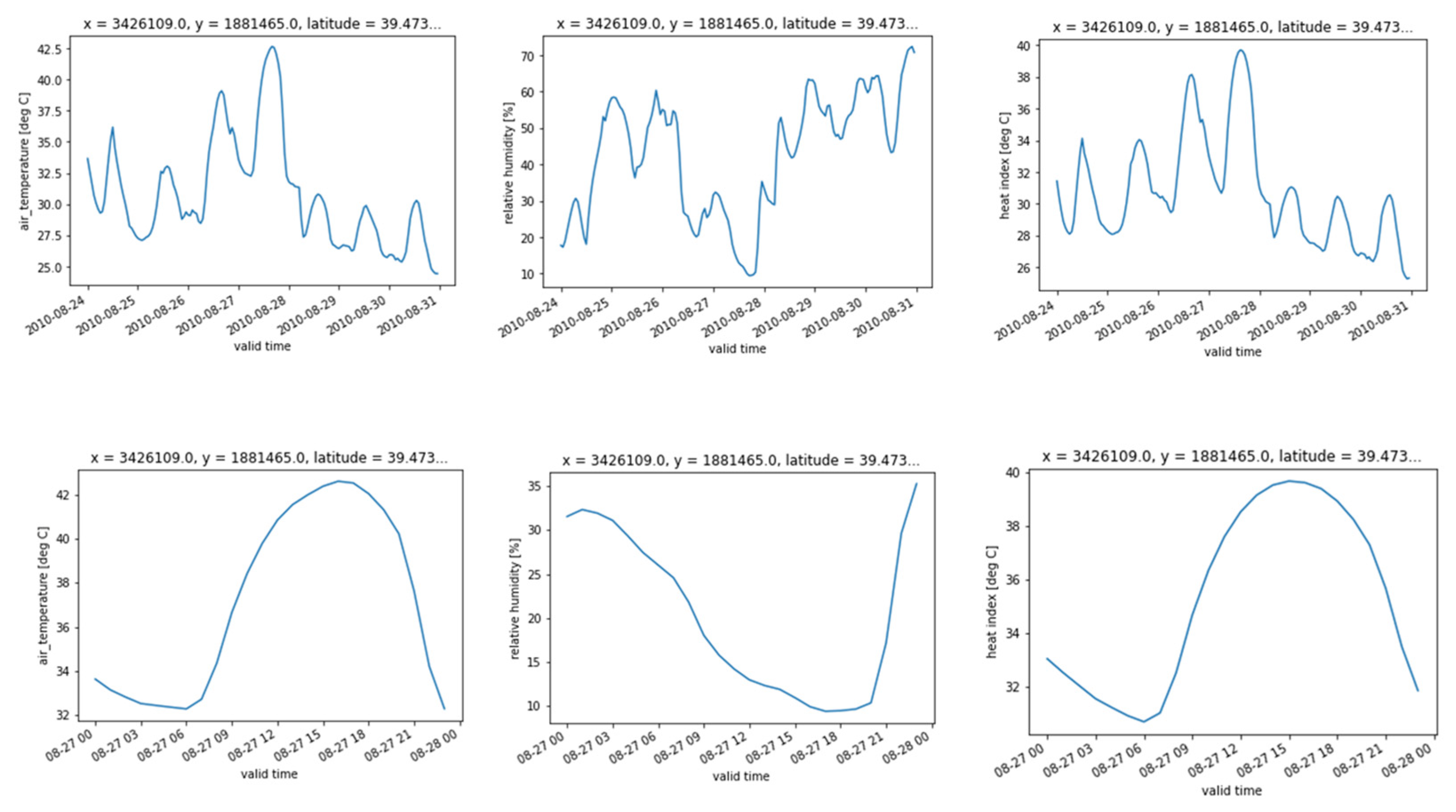
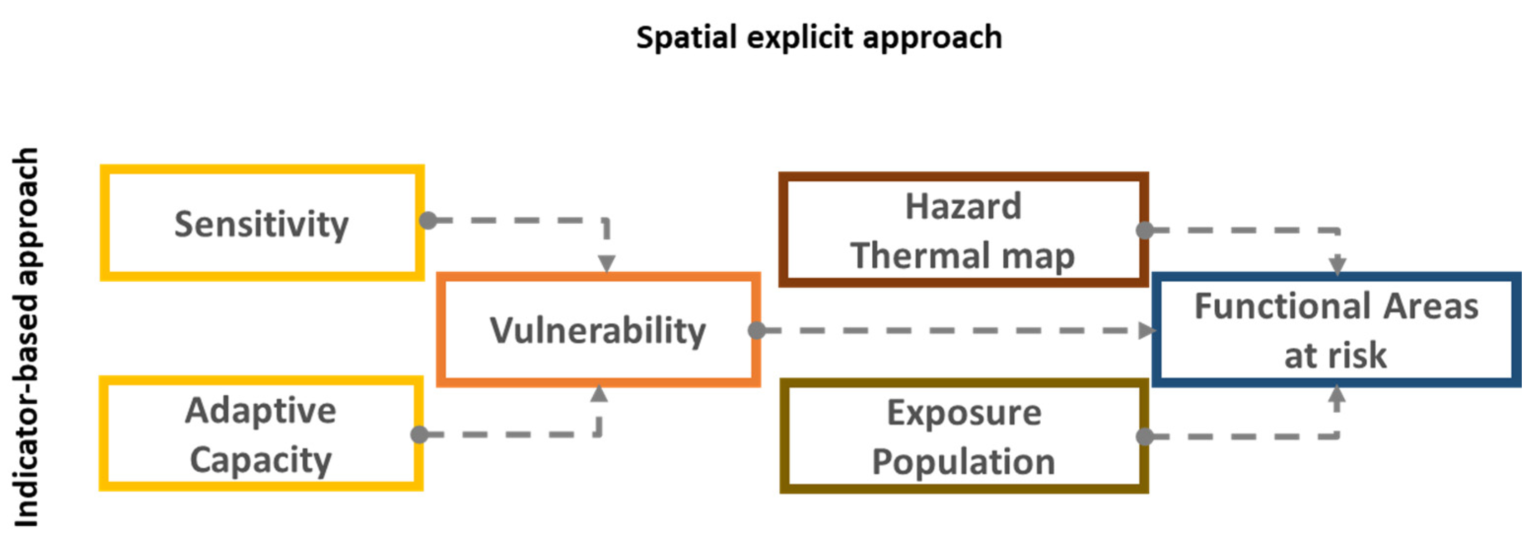
2.1. Study Design and Data Sources
2.2. Procedures
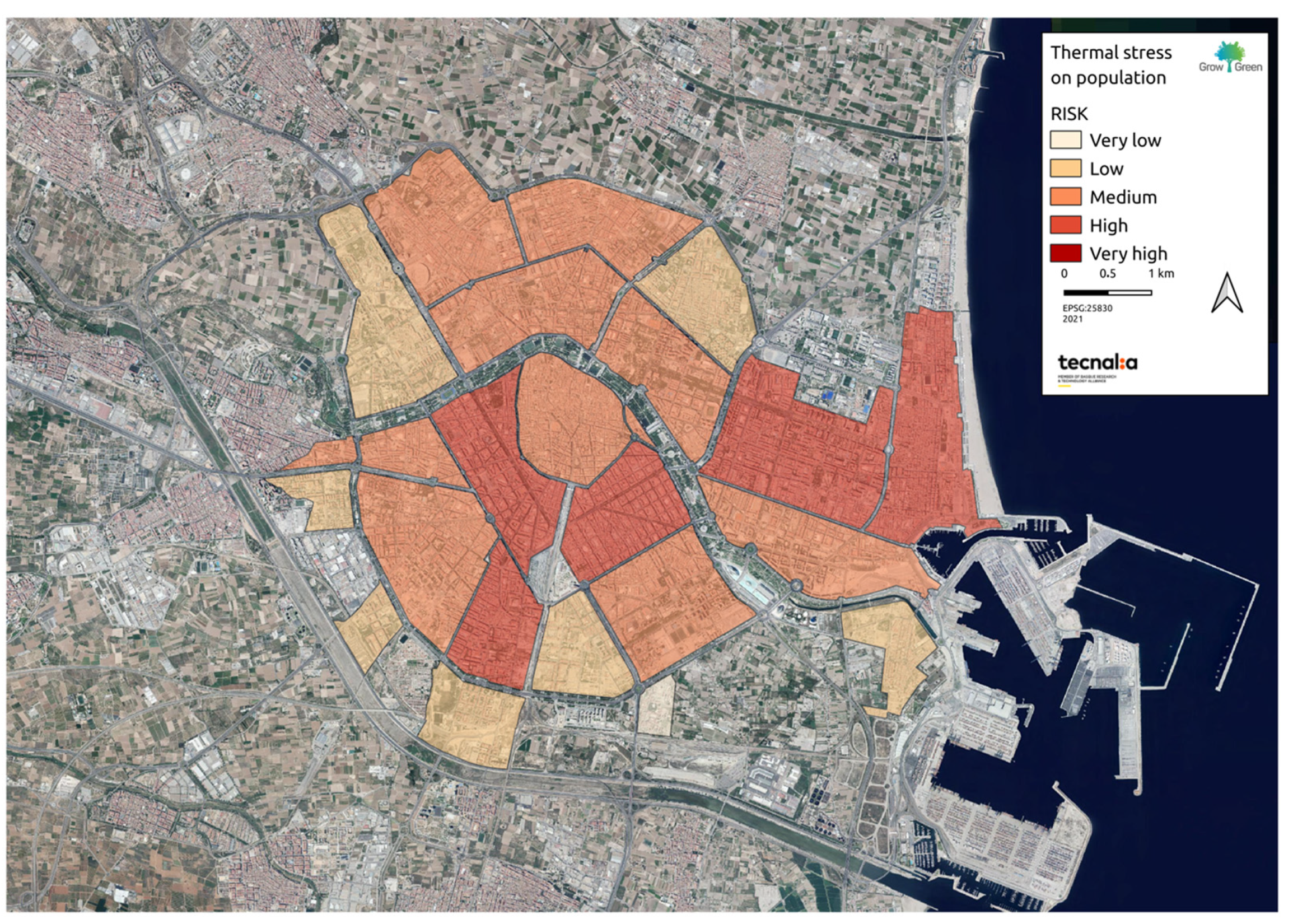
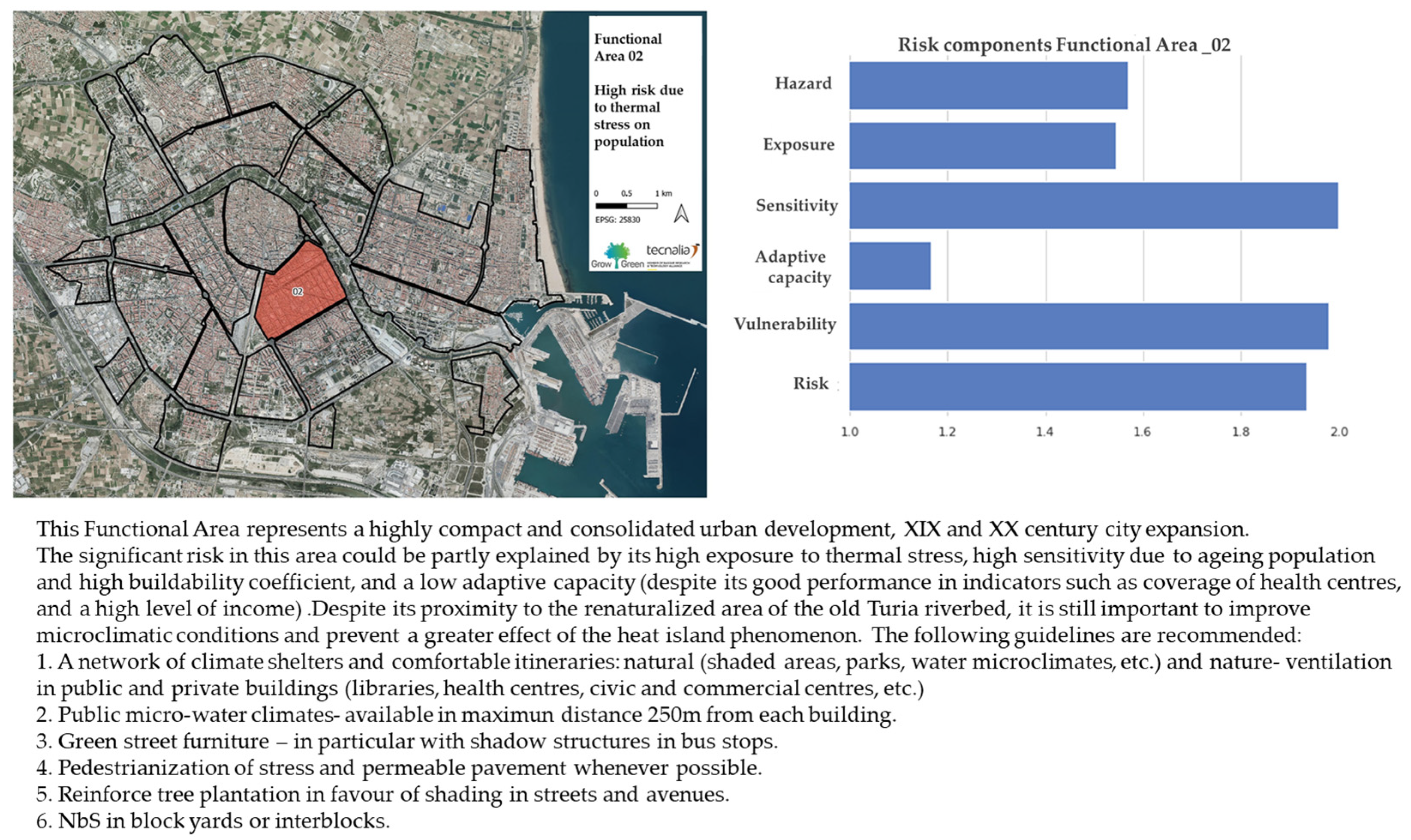
3. Results
- -
- Perform tailored studies at the city scale for the analysis of climate-related hazards and the associated risks, prioritizing the following: flash floods, water scarcity, and forest fires.
- -
- Define and include in the General Urban Development Plan the minimum content and basic orientations for undertaking vulnerability and risk assessments when elaborating development planning instruments (partial plans, special plans, etc.), in new development areas and/or regeneration projects.
- -
- Identify the priority areas of action for the implementation of NbS, considering their vulnerability and climate risk as well as their maximum potential for deployment of NbS. The priority areas of action can be included in the progress documents of the General Urban Development Plan as well as the related strategic environmental reports.
- -
- Elaborate opportunity mapping of green infrastructure and NbS deployment in the city, including the capacity to implement different types of NbS for climate resilience [37].
- -
- Define synergetic actions between adaptation and mitigation measures.
- -
- Emission proof the adaptation measures to identify potential mal-adaptations or conflicts with mitigation measures.
- -
- Identify areas in the city with increasing energy demand due to climate change-linked climatization/household or industry air conditioning.
4. Discussion
- -
- Combined hazard studies: air quality and urban climate on population health.
- -
- Water stress and footprint on economic activities (e.g., tourism)
- -
- Flooding due to surface runoff associated with extreme precipitation events affecting population, transportation, and economic activities.
- -
- Flooding due to sea level rise and waves in the urban environment.
- -
- Forest fires in urban–rural fringe.
- -
- Vulnerability and risk studies at the suburban level for the different impact chains associated with climate change would allow the identification of priority action areas, which would require municipal resources and urbanization, or regeneration interventions aimed at reducing vulnerability and risk by implementing better informed adaptation measures.
5. Conclusions
Author Contributions
Funding
Data Availability Statement
Acknowledgments
Conflicts of Interest
References
- Barker, A.; Feliú, E.; Garcia-Blanco, G.; Kwiecinska, K.; Pedrola, B. Sustainability Assessment of Urban Infrastructures. In Nature-Based Solutions for More Sustainable Cities—A Framework Approach for Planning and Evaluation; Croci, E., Lucchitta, B., Eds.; Emerald Publishing Limited: Bingley, UK, 2021; pp. 97–110. [Google Scholar] [CrossRef]
- IPCC. Climate Change 2014: Impacts, Adaptation, and Vulnerability. Part A: Global and Sectoral Aspects. Contribution of Working Group II to the Fifth Assessment Report of the Intergovernmental Panel on Climate Change; Cambridge University Press: Cambridge, UK; New York, NY, USA, 2014. [Google Scholar]
- IPCC. Climate Change 2022: Impacts, Adaptation, and Vulnerability. Contribution of Working Group II to the Sixth Assessment Report of the Intergovernmental Panel on Climate Change; Cambridge University Press: Cambridge, UK, 2022. [Google Scholar]
- UNDRR. How to Make Cities More Resilient: A Handbook for Local Government Leaders; UNDRR: Geneva, Switzerland, 2012; p. 102. [Google Scholar]
- UNISDR. Sendai Framework for Disaster Risk Reduction 2015–2030; United Nations: New York, NY, USA, 2015. [Google Scholar]
- Enzi, V.; Cameron, B.; Dezsényi, P.; Gedge, D.; Mann, G.; Pitha, U. Nature-Based Solutions and Buildings—The Power of Surfaces to Help Cities Adapt to Climate Change and to Deliver Biodiversity. In Nature-Based Solutions to Climate Change Adaptation in Urban Areas: Linkages between Science, Policy and Practice; Kabisch, N., Korn, H., Stadler, J., Bonn, A., Eds.; Theory and Practice of Urban Sustainability Transitions; Springer International Publishing: Cham, Switzerland, 2017; pp. 159–183. [Google Scholar] [CrossRef]
- Directorate-General for Research and Innovation (European Commission). Evaluating the Impact of Nature-Based Solutions: A Handbook for Practitioners; Publications Office of the European Union 2021. Available online: https://data.europa.eu/doi/10.2777/244577 (accessed on 28 April 2023).
- United Nations Department of Economic and Social Affairs, ‘World Population Prospects 2019’. 2019. Available online: https://population.un.org/wpp/publications/files/wpp2019_highlights.pdf (accessed on 29 April 2023).
- Liu, Y.; Zhou, Y.; Ju, W.; Wang, S.; Wu, X.; He, M.; Zhu, G. Impacts of droughts on carbon sequestration by China’s terrestrial ecosystems from 2000 to 2011. Biogeosciences 2014, 11, 2583–2599. [Google Scholar] [CrossRef]
- Valone, T.F. Linear Global Temperature Correlation to Carbon Dioxide Level, Sea Level, and Innovative Solutions to a Projected 6 °C Warming by 2100. J. Geosci. Environ. Prot. 2021, 9, 84–135. [Google Scholar] [CrossRef]
- World Health Organization Regional Office for Europe. European Environment and Health Process Urban Green Spaces and Health: A Review of Evidences 2016. Available online: https://apps.who.int/iris/handle/10665/345751 (accessed on 13 April 2023).
- Sturiale, L.; Scuderi, A. The Role of Green Infrastructures in Urban Planning for Climate Change Adaptation. Climate 2019, 7, 119. [Google Scholar] [CrossRef]
- Comission of the European Parliament, Communication from the Commission to the European Parliament, the Council, the European Economic and Social Committee and the Committee of the Regions Forging a Climate-Resilient Europe—The New EU Strategy on Adaptation to Climate Change. 2021. Available online: https://eur-lex.europa.eu/legal-content/EN/TXT/?uri=COM:2021:82:FIN (accessed on 29 April 2023).
- European Commission, European Climate Law. Available online: https://climate.ec.europa.eu/eu-action/european-green-deal/european-climate-law_en (accessed on 13 April 2023).
- Jefatura del Estado. Ley 7/2021, de 20 de Mayo, de Cambio Climático y Transición Energética. Spanish State official newsletterVolume BOE-A-2021-8447. 2021, pp. 62009–62052. Available online: https://www.boe.es/eli/es/l/2021/05/20/7 (accessed on 13 April 2023).
- BOE-A-2015-11723 Real Decreto Legislativo 7/2015, de 30 de Octubre, Por el Que se Aprueba el Texto Refundido de la Ley de Suelo y Rehabilitación Urbana. Available online: https://www.boe.es/buscar/act.php?id=BOE-A-2015-11723 (accessed on 13 April 2023).
- Tyrväinen, L.; Ojala, A.; Korpela, K.; Lanki, T.; Tsunetsugu, Y.; Kagawa, T. The influence of urban green environments on stress relief measures: A field experiment. J. Environ. Psychol. 2014, 38, 1–9. [Google Scholar] [CrossRef]
- Al Sayah, M.J.; Versini, P.-A.; Schertzer, D. H2020 projects and EU research needs for nature-based adaptation solutions. Urban Clim. 2022, 44, 101229. [Google Scholar] [CrossRef]
- Faivre, N.; Fritz, M.; Freitas, T.; de Boissezon, B.; Vandewoestijne, S. Nature-Based Solutions in the EU: Innovating with nature to address social, economic and environmental challenges. Environ. Res. 2017, 159, 509–518. [Google Scholar] [CrossRef] [PubMed]
- Lafortezza, R.; Sanesi, G. Nature-based solutions: Settling the issue of sustainable urbanization. Environ. Res. 2019, 172, 394–398. [Google Scholar] [CrossRef] [PubMed]
- Sanusi, R.; Bidin, S. Re-naturing cities: Impact of microclimate, human thermal comfort and 625 recreational participation. In Climate Change, Hazards and Adaptation Options. Climate Change 627 Management; Leal Filho, W., Nagy, G., Borga, M., Chávez Muñoz, P., Magnuszewski, A., Eds.; Springer: Cham, Germany, 2020; pp. 545–562. [Google Scholar]
- Mayor, B.; Toxopeus, H.; McQuaid, S.; Croci, E.; Lucchitta, B.; Reddy, S.E.; Egusquiza, A.; Altamirano, M.A.; Trumbic, T.; Tuerk, A.; et al. State of the Art and Latest Advances in Exploring Business Models for Nature-Based Solutions. Sustainability 2021, 13, 7413. [Google Scholar] [CrossRef]
- Keramitsoglou, I.; Sismanidis, P.; Analitis, A.; Butler, T.; Founda, D.; Giannakopoulos, C.; Giannatou, E.; Karali, A.; Katsouyanni, K.; Kendrovski, V.; et al. Urban thermal risk reduction: Developing and implementing spatially explicit services for resilient cities. Sustain. Cities Soc. 2017, 34, 56–68. [Google Scholar] [CrossRef]
- Gherri, B.; Maiullari, D.; Finizza, C.; Maretto, M.; Naboni, E. On the Thermal Resilience of Venetian Open Spaces. Heritage 2021, 4, 4286–4303. [Google Scholar] [CrossRef]
- Ayuntamiento de Valencia, ‘Urban Estrategy Valencia 2030’. 2020. Available online: https://estrategiaurbanavlc2030.es/thestrategy/ (accessed on 13 April 2023).
- Missions València 2030|Un modelo de gobernanza de la innovación: Missions València 2030. Available online: https://www.missionsvalencia.eu/?lang=es (accessed on 13 April 2023).
- Ley de Cambio Climático y Transición Ecológica de la Comunitat Valenciana—Cambio Climático—Generalitat Valenciana. Available online: https://agroambient.gva.es/es/web/cambio-climatico/llei-de-canvi-climatic-i-transicio-ecologica-de-la-comunitat-valenciana (accessed on 13 April 2023).
- Ayuntamiento de Valencia. Plan Especial de Directrices de Calidad Urbana; Ayuntamiento de Valencia: Valencia, Spain, 2018; Available online: https://www.valencia.es/revisionplan/sites/default/files/docs/ped_web.pdf (accessed on 12 May 2023).
- Nazarian, N.; Krayenhoff, E.S.; Bechtel, B.; Hondula, D.M.; Paolini, R.; Vanos, J.; Cheung, T.; Chow, W.T.L.; de Dear, R.; Jay, O.; et al. Integrated Assessment of Urban Overheating Impacts on Human Life. Earths Future 2022, 10, e2022EF002682. [Google Scholar] [CrossRef]
- Coccolo, S.; Kämpf, J.; Scartezzini, J.-L.; Pearlmutter, D. Outdoor human comfort and thermal stress: A comprehensive review on models and standards. Urban Clim. 2016, 18, 33–57. [Google Scholar] [CrossRef]
- Feliu, E.; García, G.; Gutierrez, L.; Abajo, B.; Mendizabal, M.; Tapia, C. Guia Para la Elaboración de Planes Locales de Adaptación al Cambio Climático; Oficina Española de Cambio Climático, Ministerio de Agricultura, Alimentación y Medio Ambiente: Madrid, Spain, 2015. [Google Scholar]
- Rothfusz, L.P. The Heat Index Equation (Or, More Than You Ever Wanted to Know About Heat Index); Technical Report 9023; National Oceanic and Atmospheric Administration, National Weather Service, Office of Meteorology: Fort Worth, TX, USA, 1990. [Google Scholar]
- Blazejczyk, K.; Epstein, Y.; Jendritzky, G.; Staiger, H.; Tinz, B. Comparison of UTCI to selected thermal indices. Int. J. Biometeorol. 2012, 56, 515–535. [Google Scholar] [CrossRef] [PubMed]
- De Ridder, K.; Lauwaet, D.; Maiheu, B. UrbClim—A fast urban boundary layer climate model. Urban Clim. 2015, 12, 21–48. [Google Scholar] [CrossRef]
- IPCC. Climate Change 2014. Impacts, Adaptation and Vulnerability. Part B: Regional Aspects; Cambridge University Press: Cambridge, UK; New York, NY, USA, 2014. [Google Scholar]
- Iungman, T.; Cirach, M.; Marando, F.; Pereira Barboza, E.; Khomenko, S.; Masselot, P.; Quijal-Zamorano, M.; Mueller, N.; Gasparrini, A.; Urquiza, J.; et al. Cooling cities through urban green infrastructure: A health impact assessment of European cities. Lancet 2023, 401, 577–589. [Google Scholar] [CrossRef] [PubMed]
- Tapia, C.; Abajo-Alda, B.; Feliu, E.; Mendizabal, M.; Martínez-Sáenz, J.A.; Fernández, G.; Laburu, T.; Lejarazu, A. Profiling urban vulnerabilities to climate change: An indicator-based vulnerability assessment for European cities. Ecol. Indic. 2017, 78, 142–155. [Google Scholar] [CrossRef]
- Nardo, M.; Saisana, M.; Saltelli, A.; Tarantola, S. Handbook on Constructing Composite Indicators: Methodology and User Guide; OECD & JRC: Paris, France, 2008. [Google Scholar]
- Reid, C.E.; Mann, J.K.; Alfasso, R.; English, P.B.; King, G.C.; Lincoln, R.A.; Margolis, H.G.; Rubado, D.J.; Sabato, J.E.; West, N.L.; et al. Evaluation of a Heat Vulnerability Index on Abnormally Hot Days: An Environmental Public Health Tracking Study. Environ. Health Perspect. 2012, 120, 715–720. [Google Scholar] [CrossRef] [PubMed]
- Demuzere, M.; Orru, K.; Heidrich, O.; Olazabal, E.; Geneletti, D.; Orru, H.; Bhave, A.; Mittal, N.; Feliu, E.; Faehnle, M. Mitigating and adapting to climate change: Multi-functional and multi-scale assessment of green urban infrastructure. J. Environ. Man. 2014, 146, 107–115. [Google Scholar] [CrossRef] [PubMed]
- European Environment Agency Heat and Cold—Extreme Heat—European Environment Agency. Available online: https://www.eea.europa.eu/publications/europes-changing-climate-hazards-1/heat-and-cold/heat-and-cold-extreme-heat (accessed on 13 May 2023).
- European Commission EU Mission for Adaptation to Climate Change. European Commission—European Commission. 2022. Available online: https://ec.europa.eu/commission/presscorner/detail/en/ip_22_3527 (accessed on 13 May 2023).


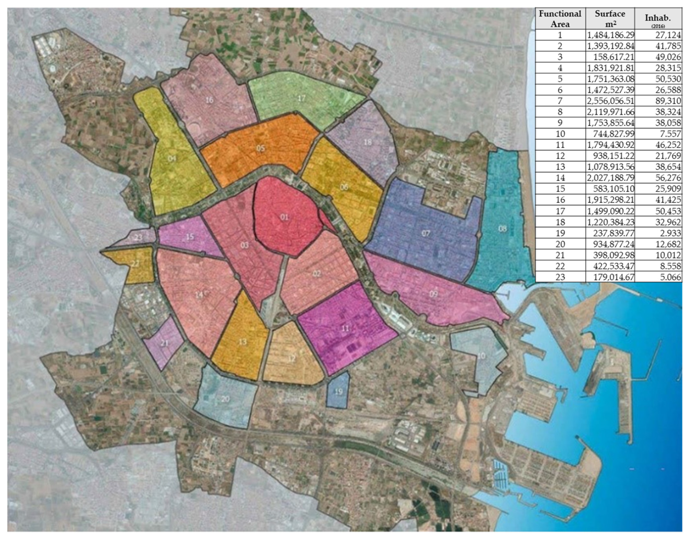
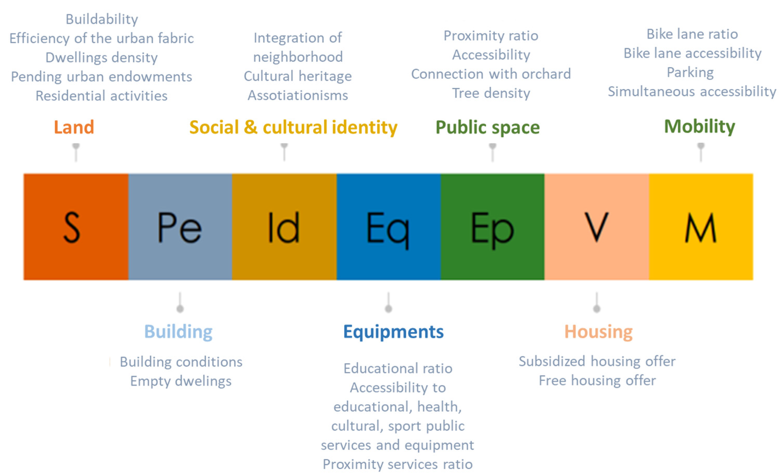
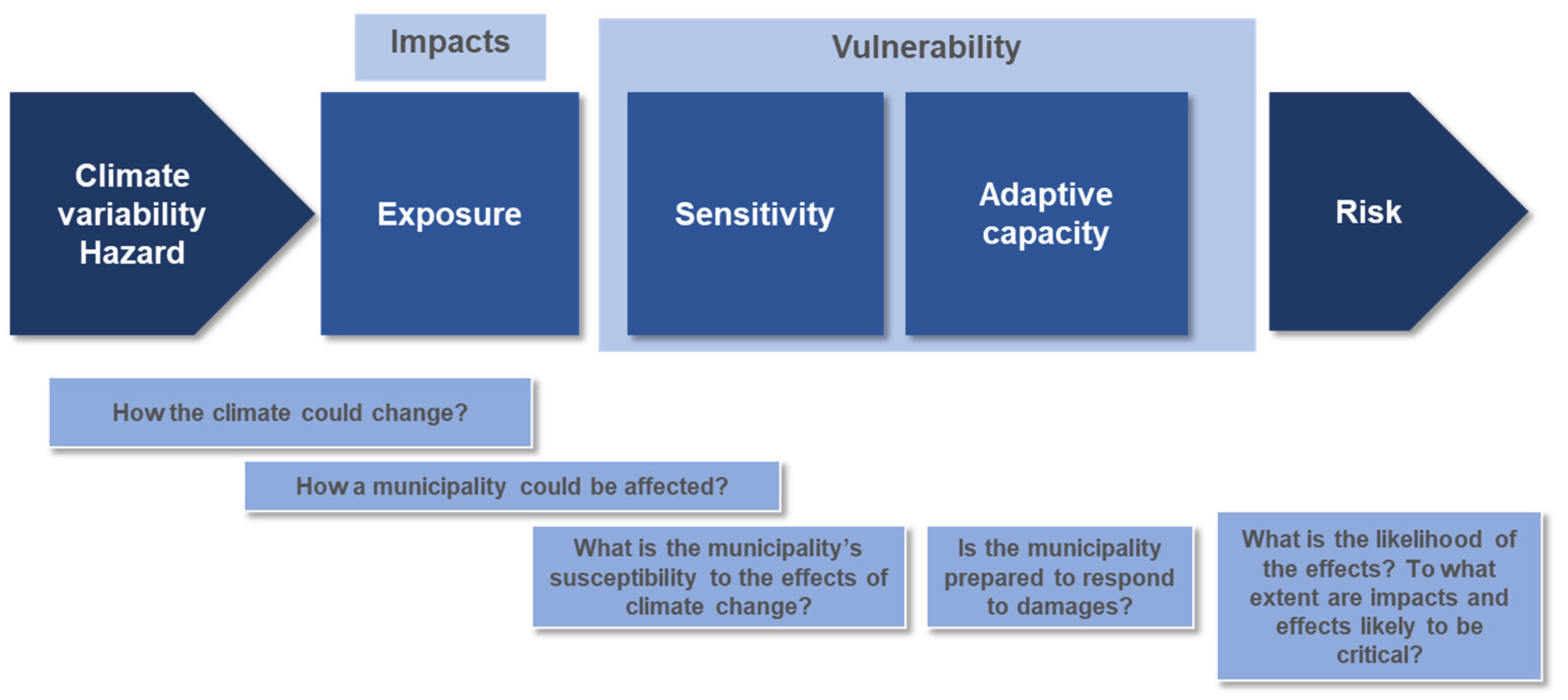
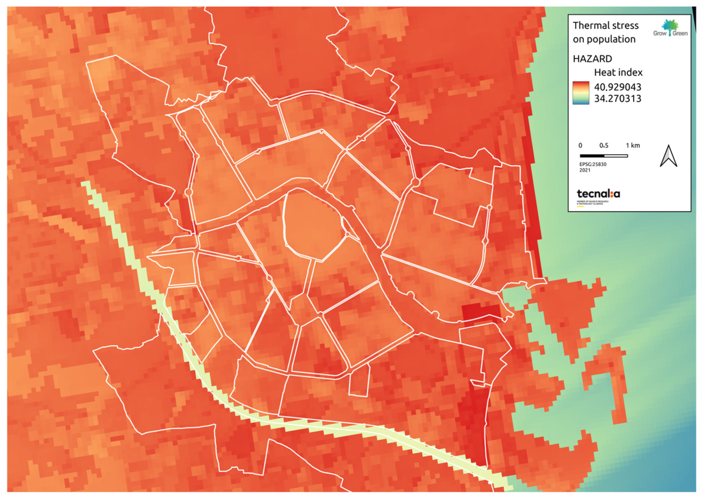
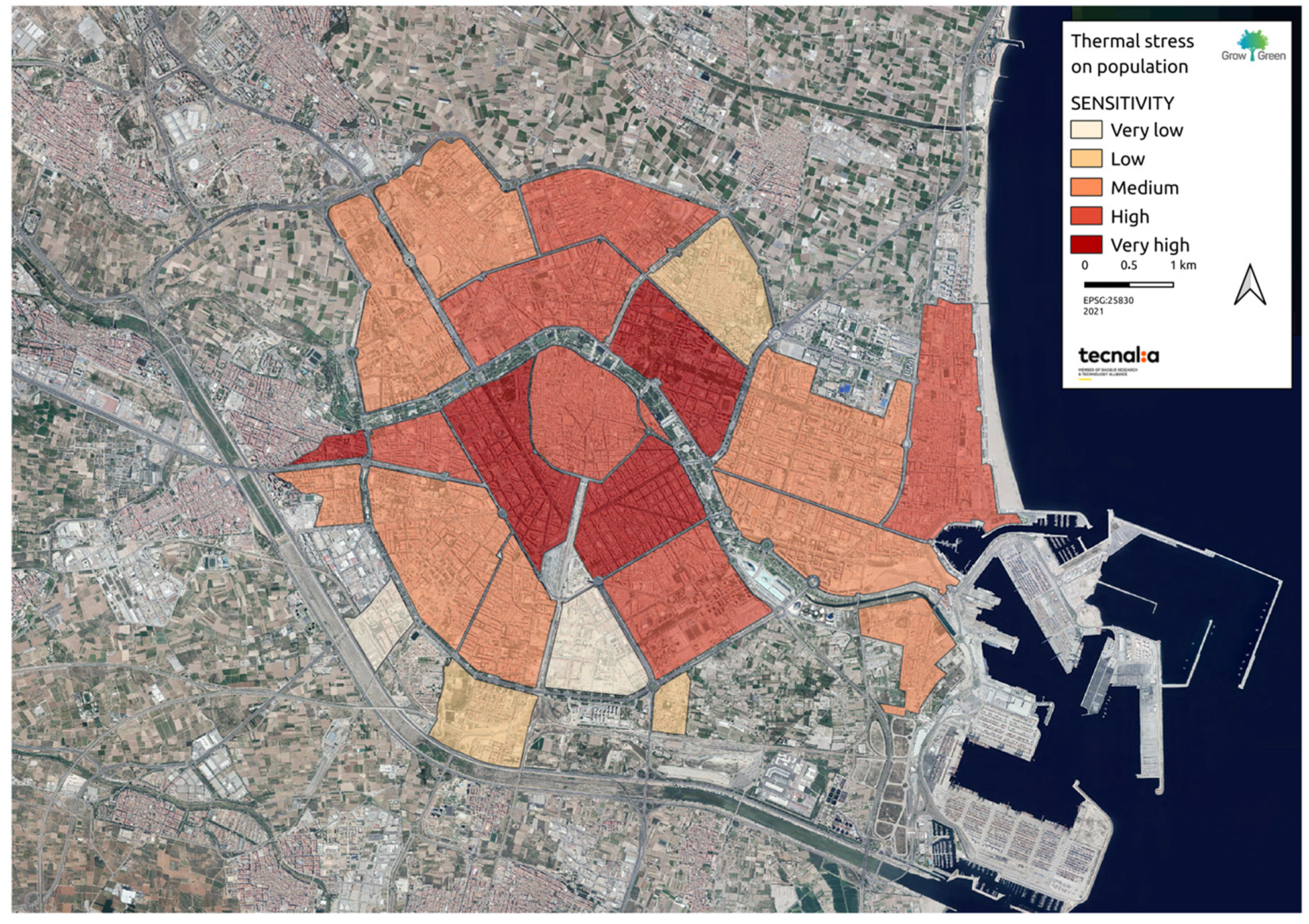
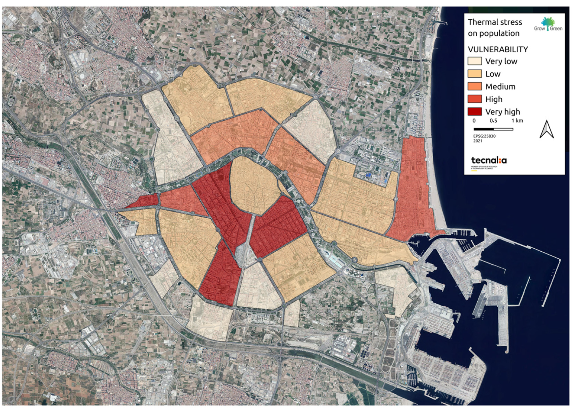
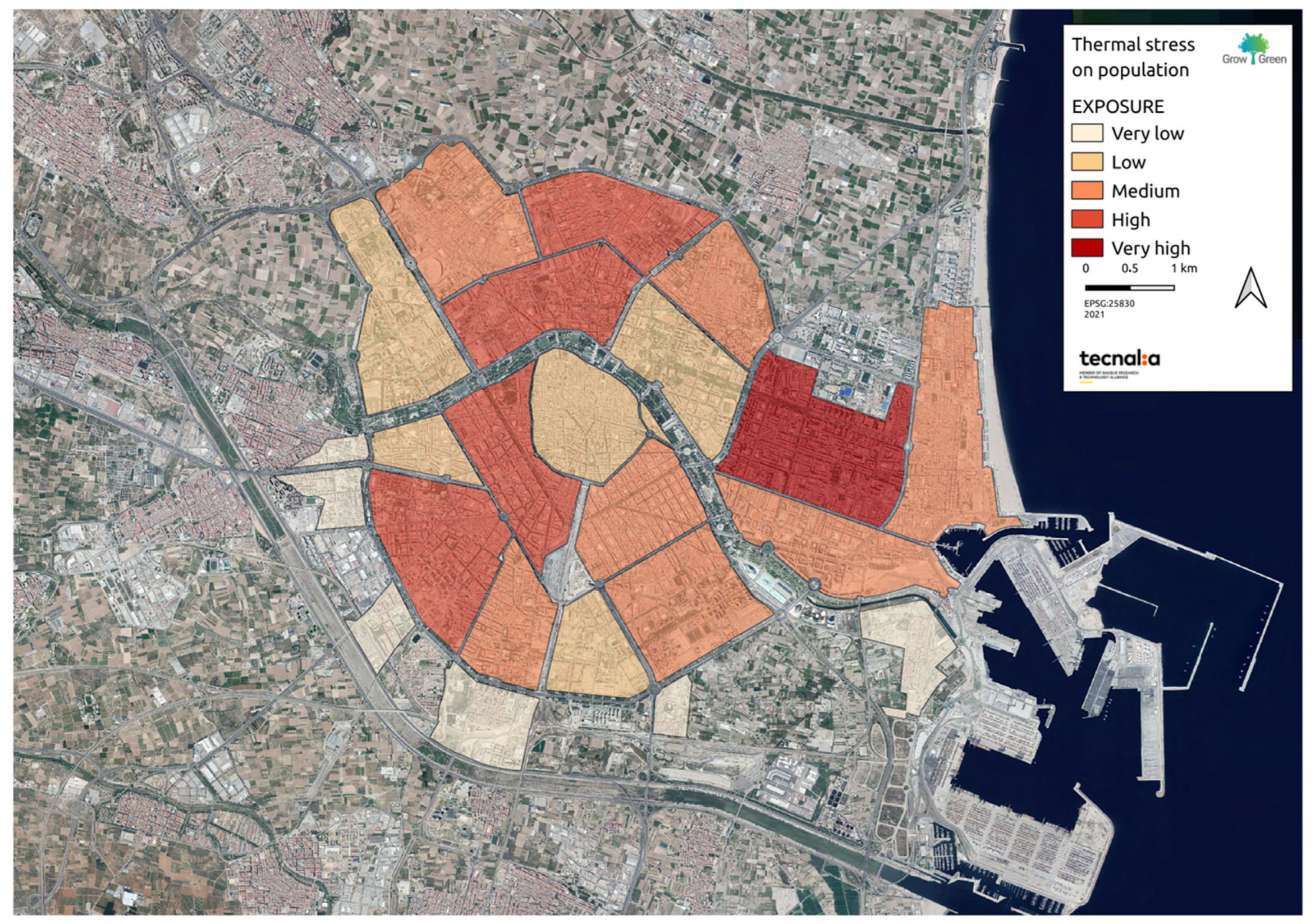
| Component | Dimension | Type | Indicator | Definition |
|---|---|---|---|---|
| HZ | Heat index | Heat index | ||
| EX | Population | Total population | Number of inhabitants per functional area | |
| VU | SE | Land | Buildability | Building coefficient per functional area |
| VU | SE | Land | Efficiency of the urban fabric | Compacity: building volume by the total surface of the functional area |
| VU | SE | Population | Population > 65 years old | % of inhabitants > 65 years old in the functional area |
| VU | SE | Population | Population < 15 years old | % of inhabitants < 15 years old in the functional area |
| VU | SE | Public space | Artificialized areas | % of impervious land by the total surface of the functional area |
| VU | SE | Housing | Old residential buildings | % of residential buildings > 50 years (reference year 2020) |
| VU | AC | Social and cultural identity | Associationism | Existing associations in the functional area |
| VU | AC | Public services/equipment | Accessibility to health centers | Coverage by radius of distance from health centers |
| VU | AC | Public services/equipment | Proximity to public facility ratio | Area of local public facilities per inhabitant |
| VU | AC | Public services/equipment | Global ratio of public facilities | Global area of public facilities per inhabitant |
| VU | AC | Public space | Proximity to free spaces ratio | Area of free spaces in proximity per inhabitant (gardens) |
| VU | AC | Public space | Proximity to free spaces ratio | Global area of free spaces per inhabitant (parks, boulevards, and gardens) |
| VU | AC | Public space | Simultaneous accessibility to free spaces | Circles of coverage by radius of distance (simultaneous accessibility to several types of free spaces) |
| VU | AC | Public space | Connectivity to the orchard | Percentage of land covered by the areas of influence of the orchards and pedestrian routes |
| VU | AC | Public space | Density of trees | Number of trees per road surface (urban comfort) |
| VU | AC | Mobility | Bike lane ratio | Linear meters of bike lanes by length of urban road |
| VU | AC | Social well-being | Household income | Average household income per functional area calculated from the average data in 2017 assigned to buildings. |
| VU | AC | Public spaces | Public fountains | Number of fountains in each functional area per hectare |
| Functional Areas | Diagnosis | Recommendations for NbS Deployment |
|---|---|---|
| Historic centre, high-density urban consolidation, compact, residential, commercial, administrative development |  | |
| These areas represent the historical centre of the city, with a compact urban fabric. The aims in these areas in relation to climate resilience are to improve microclimatic conditions and prevent the deterioration of green spaces. These aims also apply to future construction and renovations. | Design a network of climate shelters and comfortable, cool, and shady pedestrian routes. Cold islands: water microclimates—publicly available at a maximum distance of 250 m from each building. Green urban furniture—for example, conditioning of public transport stops. | |
| High-density consolidated urban, compact, residential, commercial, administrative development |  | |
| These areas represent compact urban fabric. The aims in these areas in relation to climate resilience are to improve microclimatic conditions and prevent the deterioration of green spaces. These aims also apply to future construction and renovations. | Pedestrianization of streets and permeable pavement on roads, sidewalks, parking spaces. Wooded—shading elements. Intensive cooperation with local actors. | |
| Consolidated urban-residential garden environment |  | |
| In the case of the city of València, this is a critical area due to its need for permeability with the surroundings of the orchard, city parks, farmland. Natural areas (forests, watercourses, alluvial plains). | Implementation of green and blue adaptation measures as a priority to increase connectivity in the urban–rural interface. Energy efficiency measures and sustainable building in new developments including material selection during the construction and renovation of buildings and public spaces to minimize secondary heat generation and maximize environmental cooling. Effective green management—preservation of high-quality areas (i.e., orchard) and restoration of green areas that allow connectivity with the peri-urban and rural environment of the orchard. Guarantee the connection between urban and rural areas, specifically with the orchard area. Use of the re-naturalization of linear infrastructures as ecological connectors. | |
| Promote ecosystem services in protected natural areas. | ||
| In areas where the functional use of the area allows further construction, this should be done on the condition that it does not negatively affect the microclimate in surrounding areas with higher levels of risk. | ||
| Peri-urban facilities, infrastructures |  | |
| Mainly residential areas, single-family houses, equipment. | Local construction/change of functional use must not reduce thermal comfort, so NbS must be prioritized. Energy efficiency measures and sustainable building in new developments including material selection during the construction and renovation of buildings and public spaces to minimize secondary heat generation and maximize environmental cooling. Permeable pavements in surface car parks. | |
Disclaimer/Publisher’s Note: The statements, opinions and data contained in all publications are solely those of the individual author(s) and contributor(s) and not of MDPI and/or the editor(s). MDPI and/or the editor(s) disclaim responsibility for any injury to people or property resulting from any ideas, methods, instructions or products referred to in the content. |
© 2023 by the authors. Licensee MDPI, Basel, Switzerland. This article is an open access article distributed under the terms and conditions of the Creative Commons Attribution (CC BY) license (https://creativecommons.org/licenses/by/4.0/).
Share and Cite
García-Blanco, G.; Navarro, D.; Feliu, E. Adopting Resilience Thinking through Nature-Based Solutions within Urban Planning: A Case Study in the City of València. Buildings 2023, 13, 1317. https://doi.org/10.3390/buildings13051317
García-Blanco G, Navarro D, Feliu E. Adopting Resilience Thinking through Nature-Based Solutions within Urban Planning: A Case Study in the City of València. Buildings. 2023; 13(5):1317. https://doi.org/10.3390/buildings13051317
Chicago/Turabian StyleGarcía-Blanco, Gemma, Daniel Navarro, and Efren Feliu. 2023. "Adopting Resilience Thinking through Nature-Based Solutions within Urban Planning: A Case Study in the City of València" Buildings 13, no. 5: 1317. https://doi.org/10.3390/buildings13051317