
Digital Twin for Xiegong’s Architectural Archaeological Research: A Case Study of Xuanluo Hall, Sichuan, China

Abstract
:1. Introduction
2. Related Works
2.1. Digital Heritage
2.2. BIM for Heritage Buildings
2.3. Digital Twin
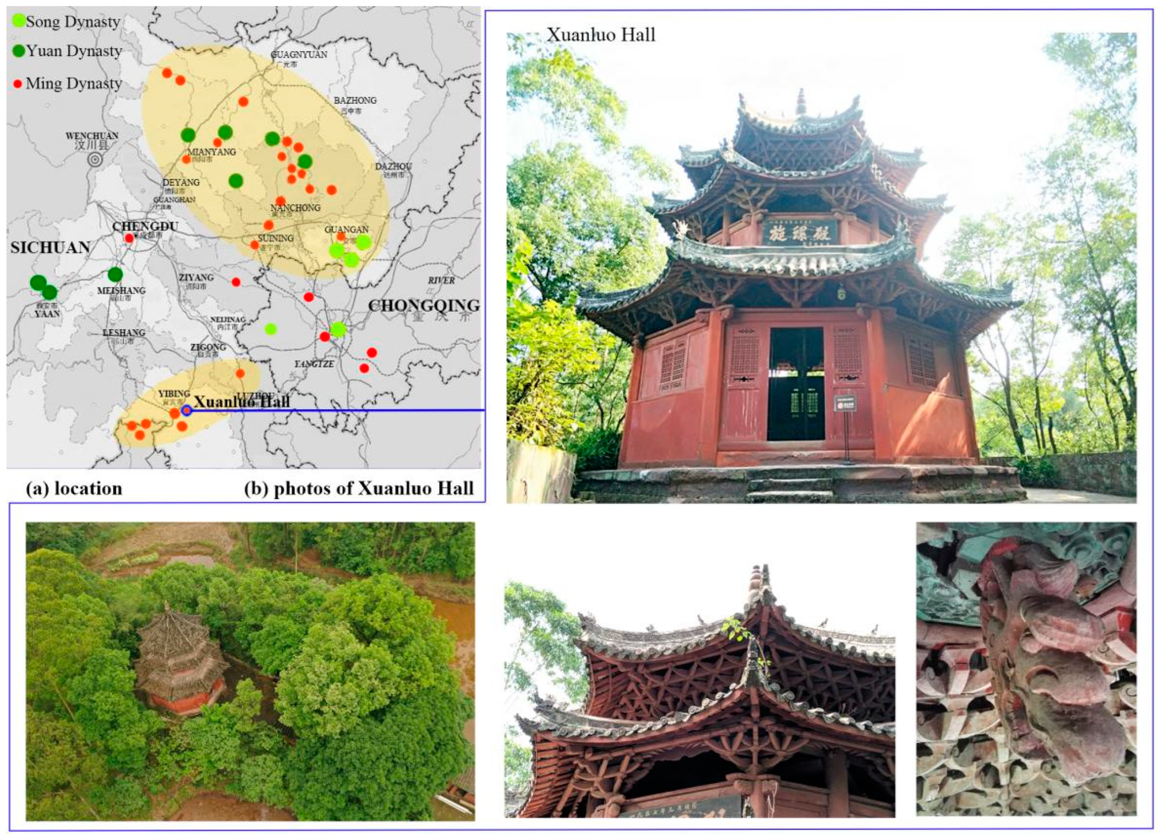
3. Study Site
4. Methods
4.1. Theory of Architectural Archaeology
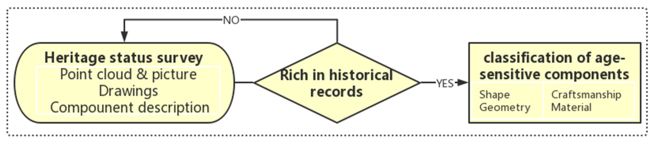
4.1.1. Surveying and Classification of Shape Features
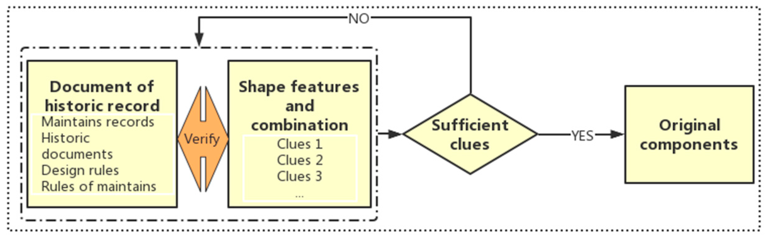
4.1.2. Identifying the Original Components and Original Design
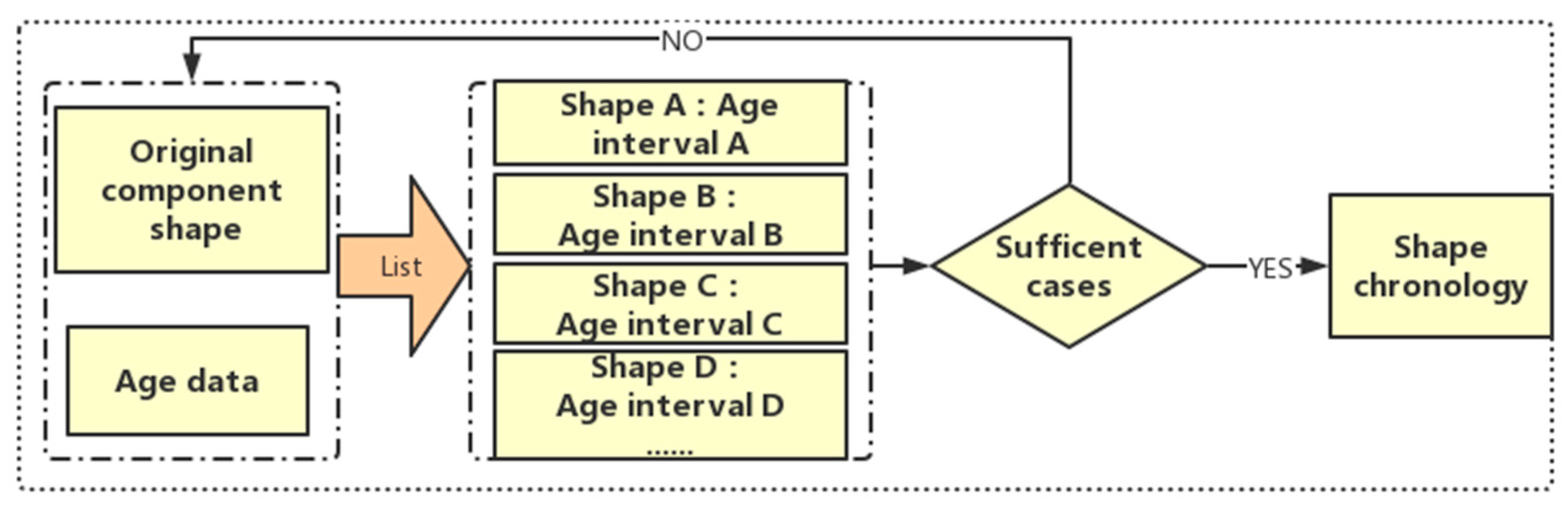
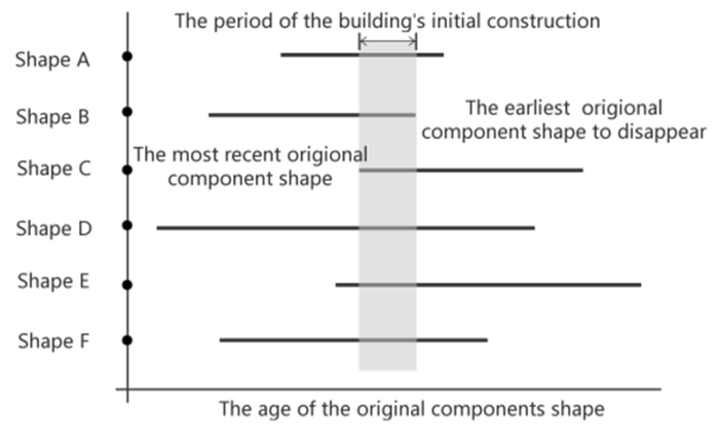
4.1.3. Compilation of Shape Chronology
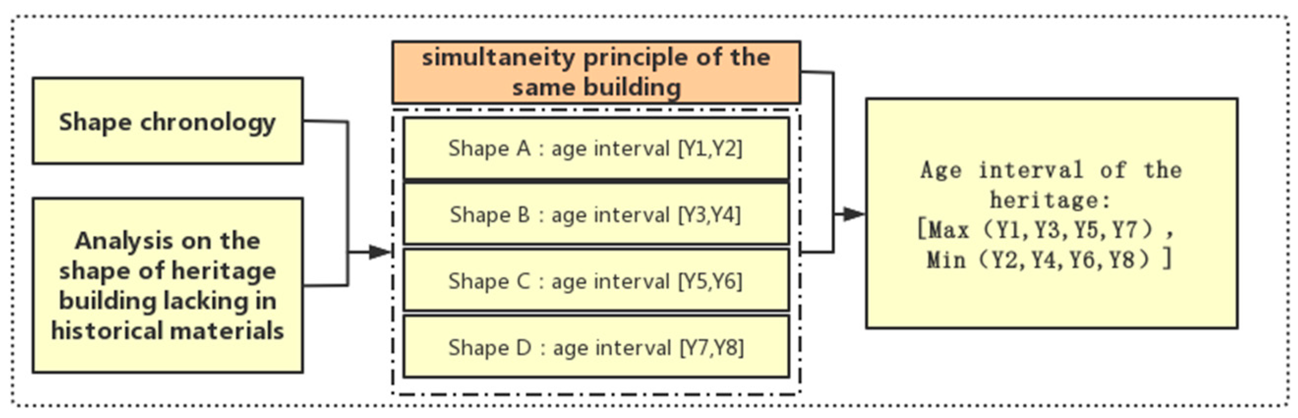
4.1.4. Dating of Single Buildings
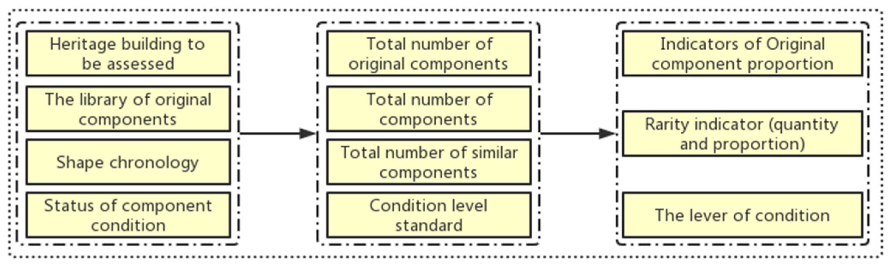
4.1.5. Reference Indicators for Heritage Evaluation
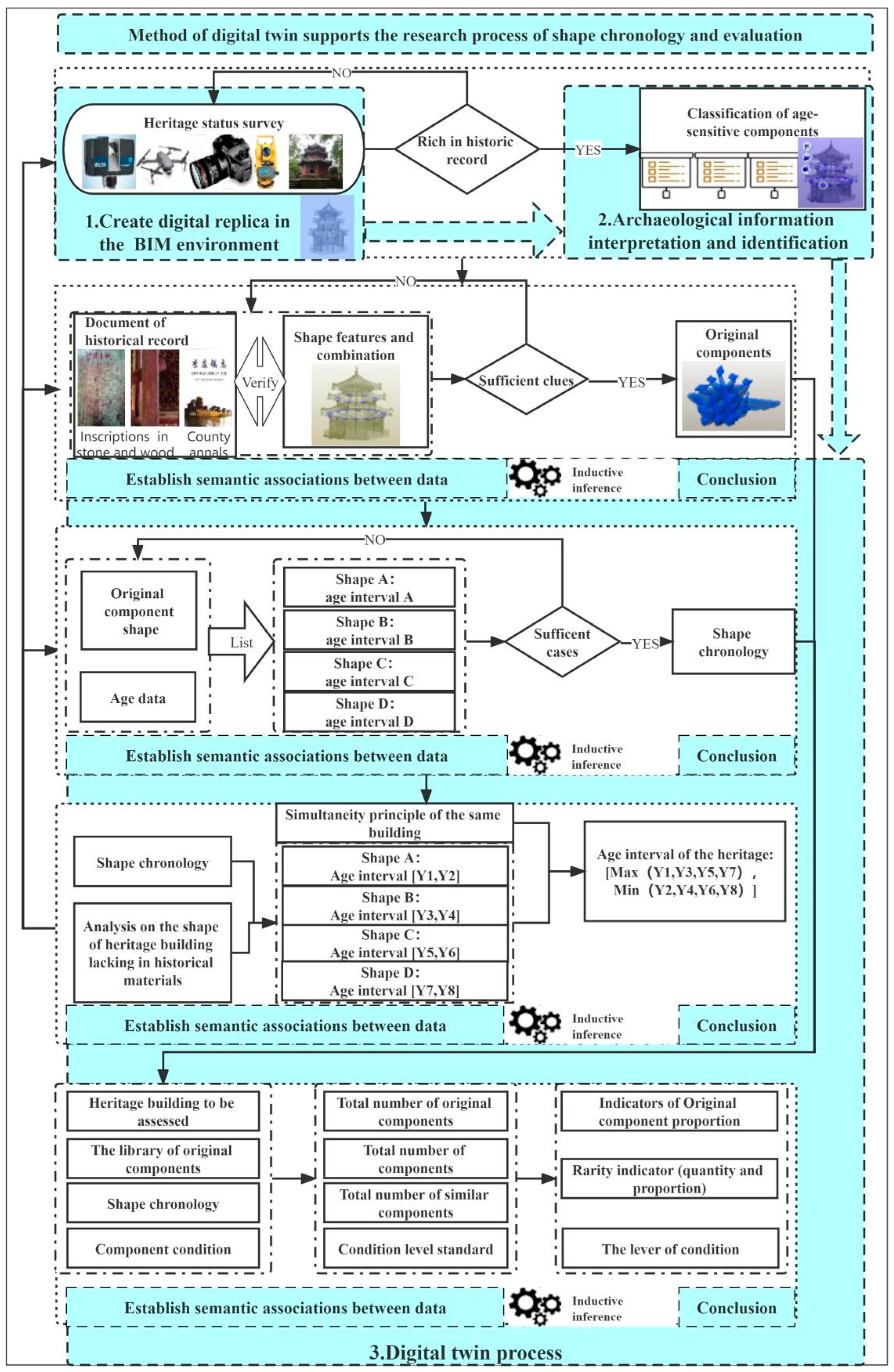
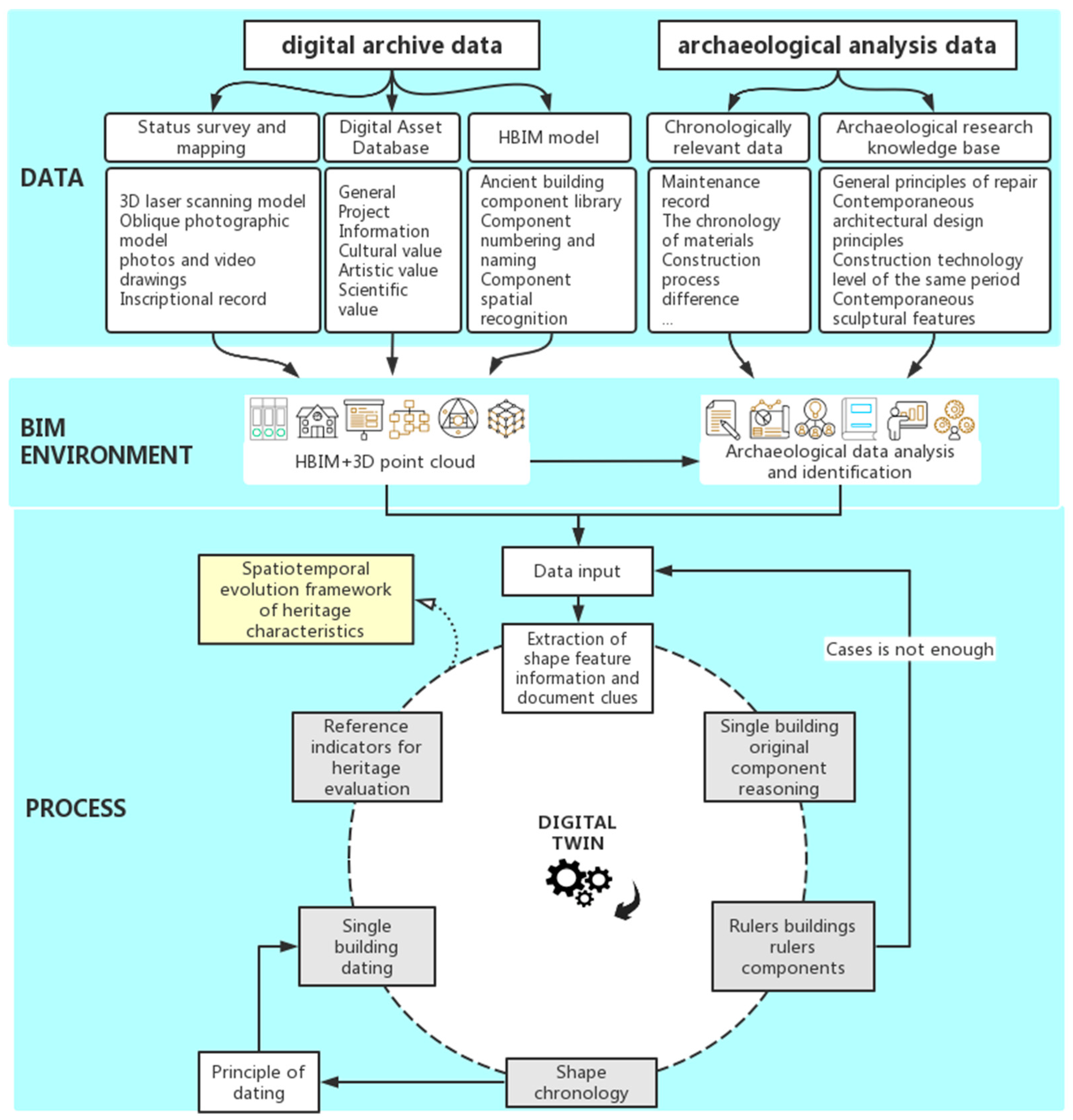
4.2. Digital Twin: A BIM-Based Comprehensive Method for the Archaeological Plan
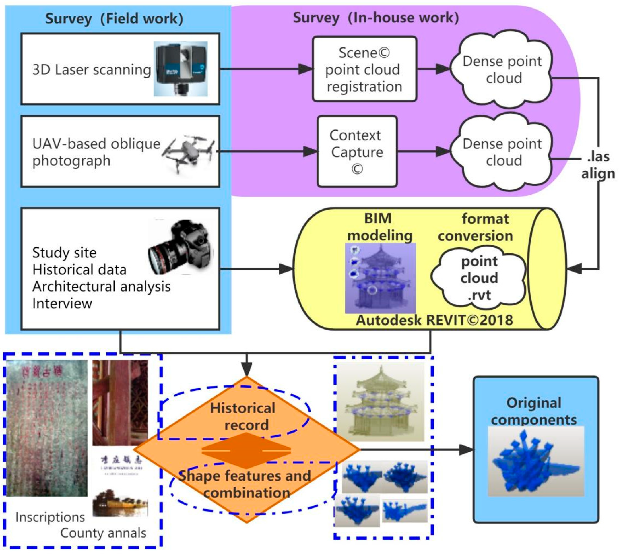
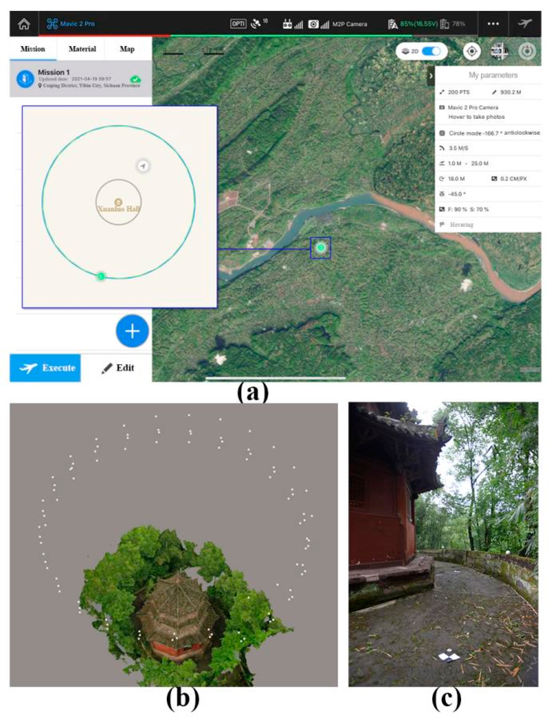
4.2.1. Build a Digital Replica in a BIM Environment
4.2.2. Archaeological Data Interpretation and Identification
4.2.3. Digital Twin Process to Support Architecture Archaeology
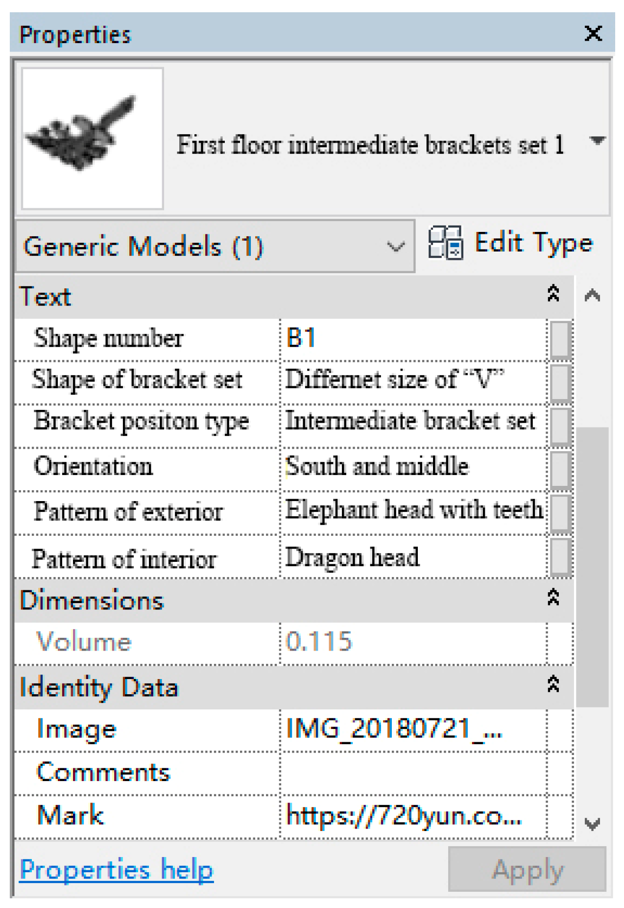
4.3. Data Management in the BIM Environment
5. Result
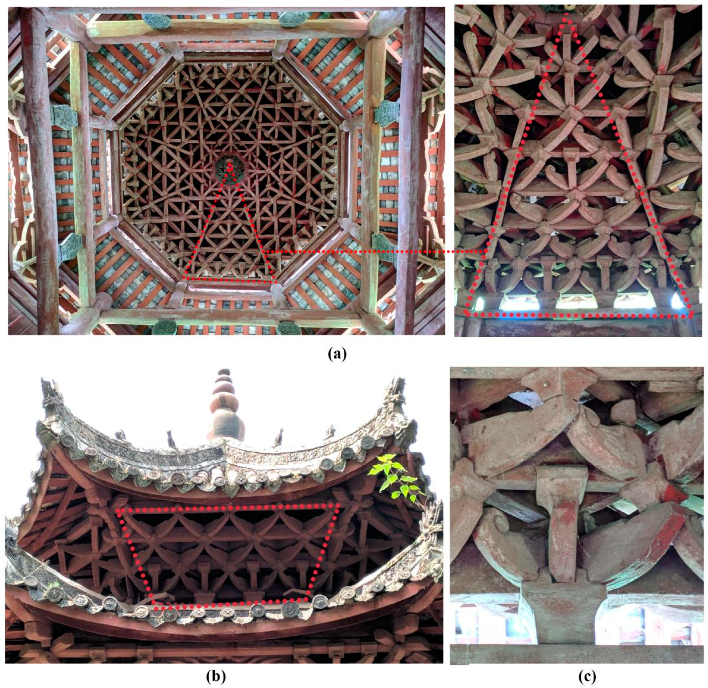
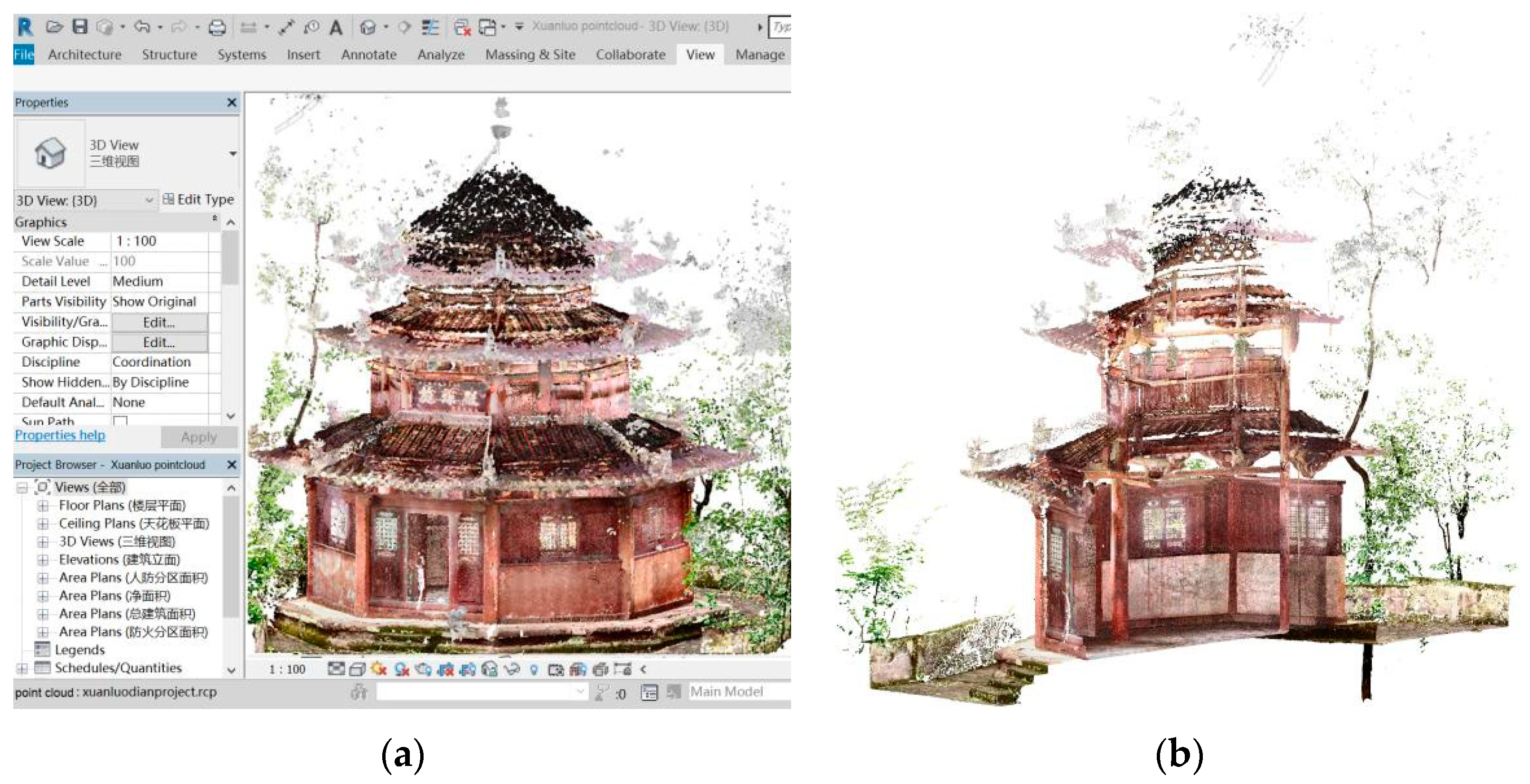
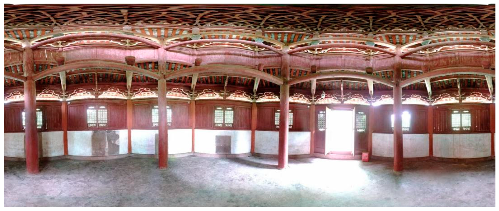
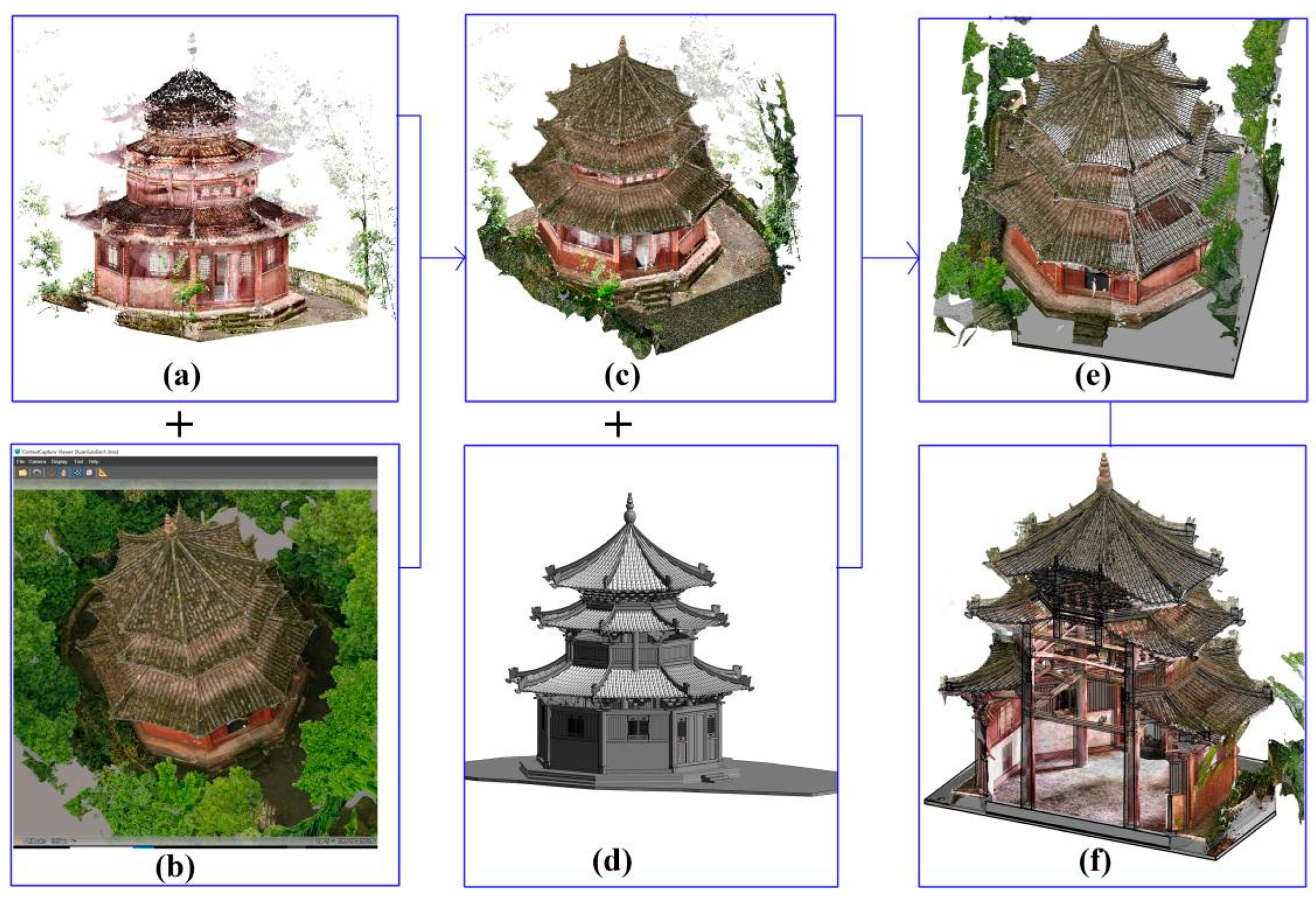
5.1. The Digital Replica of the Xuanluo Hall
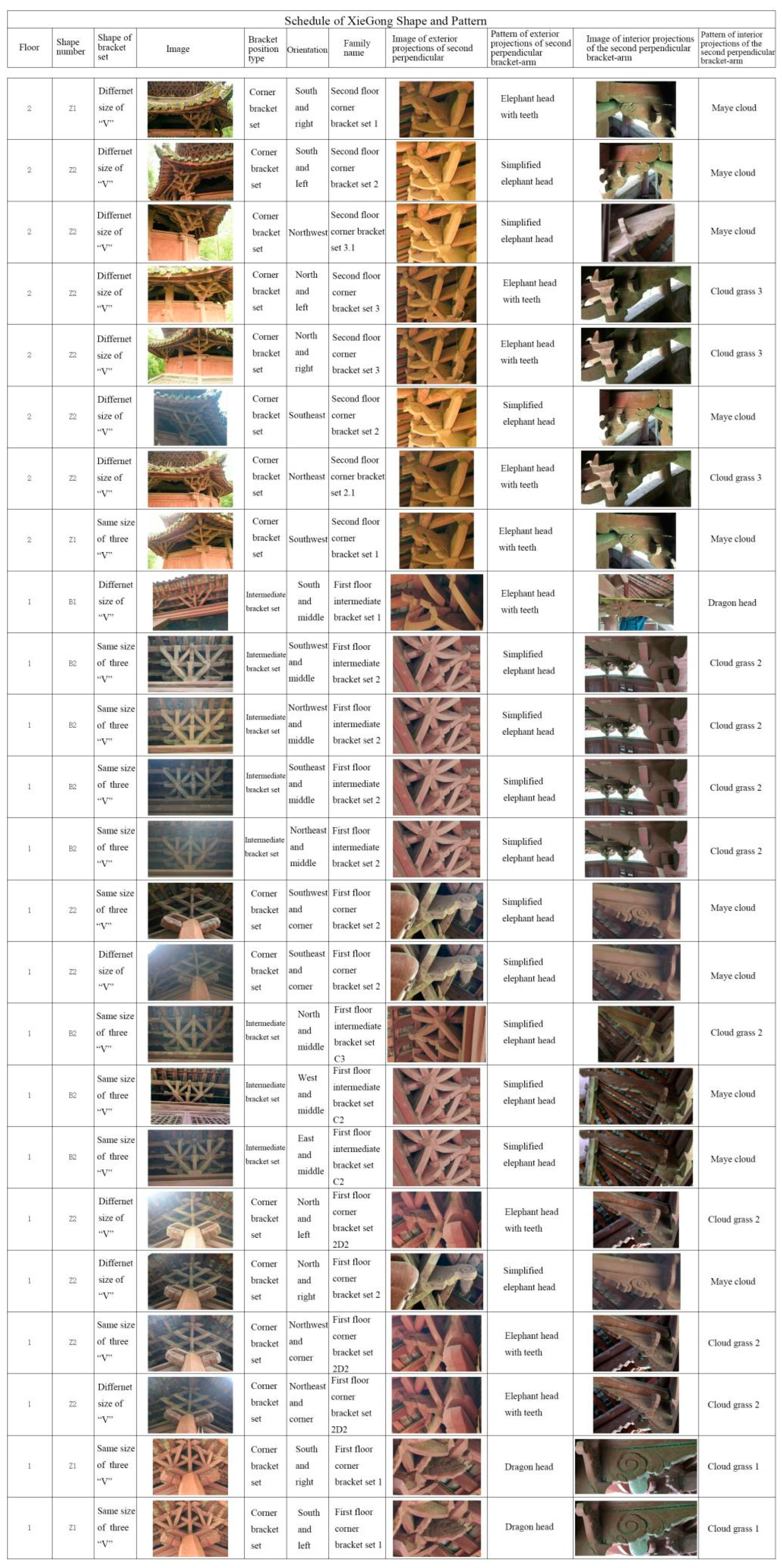
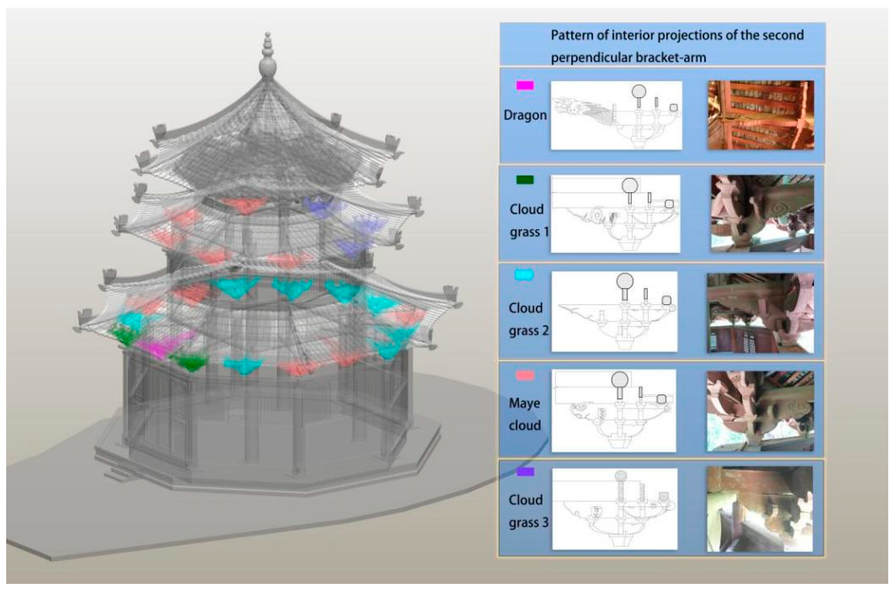
5.2. Archaeological Data within the Digital Twin
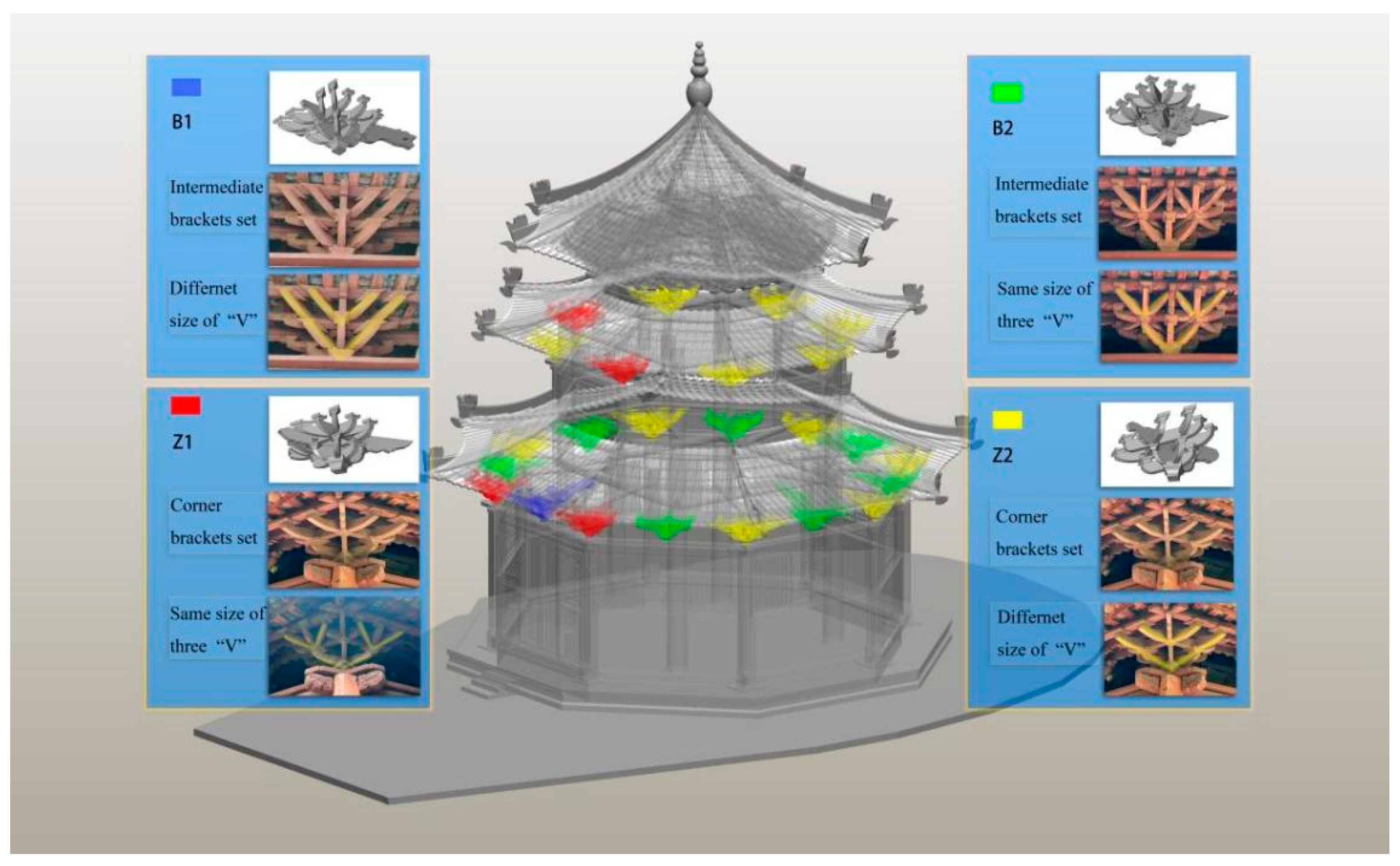
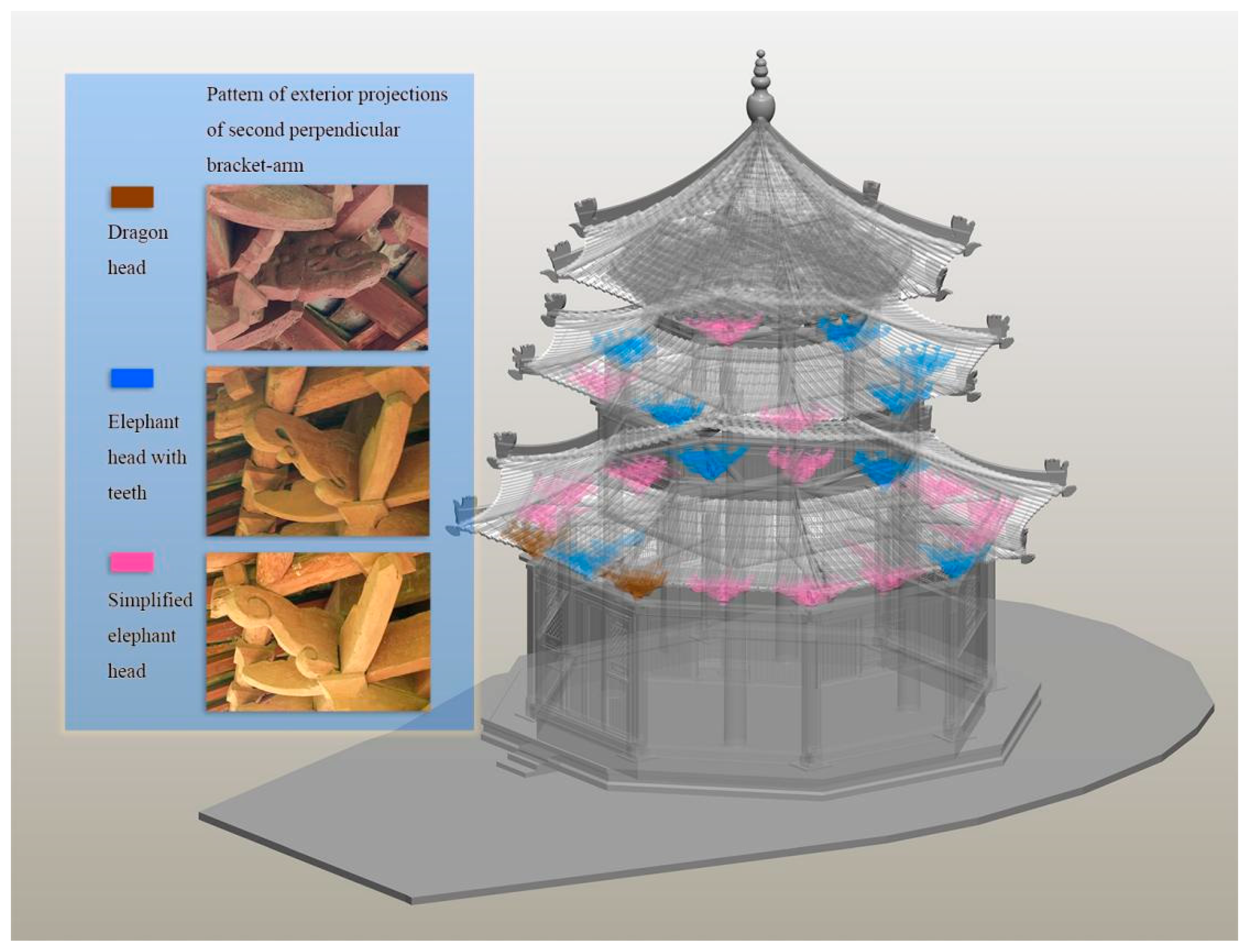
5.3. Presentation of Archaeological Information for Reasoning
6. Discussion
7. Conclusions and Future Work
- Currently, there is no systematic method based on the principle of Xu’s shape chronology and a quantitative method of cultural estimation. This method applies not only to the archaeological dating of the Xiegong heritage but also to the official Dougong heritage.
- The data collected by 3D mapping technology are sufficient and avoid the loss of information caused by traditional information recording methods such as CAD drawing. It also provides reliable reference indices for cultural relic value evaluation.
- A 3D model that faithfully records the status and details of the heritage can be viewed in the BIM environment, which solves the problem of the archaeologist who cannot visit the site.
- The BIM model provides a medium for information storage for the process and results of architectural archaeological identification and analysis. It can be stored in the BIM environment or linked to an external database, providing archaeologists with various query methods.
- The digital twin process can better deal with the uncertainty of archaeological data. When new data are added to the BIM environment, it can update the related data synchronously to avoid errors caused by outdated information.
- There is currently a method to combine point cloud and photographic models into one model, which maintains accuracy and reflects reality. This method is ready to be adopted in the following case, but it may also meet the challenge of occlusion of the surrounding environment.
- Programs will be written according to the general steps and possible situations of Xiegong archaeological research in the future to improve the automation of the process.
- A data model will be developed for the data management of archaeological temporal evolution information. A prototype data structure for indicators related to heritage importance will be developed. In addition, interoperability issues need to be further studied.
- Building a platform and database for architectural archaeological research is the ultimate goal. A multi-user mode to provide a platform for data support, discussion, and exchange for different archaeological researchers may be a future research direction.
Author Contributions
Funding
Institutional Review Board Statement
Informed Consent Statement
Data Availability Statement
Acknowledgments
Conflicts of Interest
References
- Leng, J.; Rao, M.; Cheng, K.; Feng, D. An Exploration on the Design Intention and Original State of Dougong of Lizhuang Xuanluo Hall in Yibin, Sichuan Province: A Comparative Reading Between the Article Xuanluo Hall in 1944 and the Xuanluo Hall Building in 2018. J. Hum. Settl. West China 2020, 35, 121–128. [Google Scholar]
- Wu, L.; Tang, X.; Zhao, Q. Decoding the Construction Techniques of Crossed Oblique Bow-Shaped Units of Cellular Bracket System in the Ethnic Dong Drum-Tower. Archit. J. 2019, 2, 106–111. [Google Scholar]
- Alexandra, H.; Lin, L. Two Nomenclature and Classification of Angled Bracket-arms: Shanshi Dougong, Ruyi Dougong. Tradit. Chin. Archit. Gard. 2012, 2, 11–18. [Google Scholar]
- Croce, V.; Caroti, G.; Piemonte, A. Propagation of semantic information between orthophoto and 3D replica: A H-BIM system for the north transept of Pisa Cathedral. Geomat. Nat. Hazards Risk 2021, 12, 2225–2252. [Google Scholar] [CrossRef]
- White, G.; Zink, A.; Codecá, L.; Clarke, S. A digital twin smart city for citizen feedback. Cities 2021, 110, 103064. [Google Scholar] [CrossRef]
- Austin, M.; Delgoshaei, P.; Coelho, M.; Heidarinejad, M. Architecting Smart City Digital Twins: Combined Semantic Model and Machine Learning Approach. J. Manag. Eng. 2020, 36, 04020026. [Google Scholar] [CrossRef]
- Dembski, F.; Wössner, U.; Letzgus, M.; Ruddat, M.; Yamu, C. Urban Digital Twins for Smart Cities and Citizens: The Case Study of Herrenberg, Germany. Sustainability 2020, 12, 2307. [Google Scholar] [CrossRef] [Green Version]
- Jouan, P.; Hallot, P. Digital Twin: Research Framework to Support Preventive Conservation Policies. ISPRS Int. J. Geo-Inf. 2020, 9, 228. [Google Scholar] [CrossRef] [Green Version]
- Liang, H.; Li, W.; Lai, S.; Zhu, L.; Jiang, W.; Zhang, Q. The integration of terrestrial laser scanning and terrestrial and unmanned aerial vehicle digital photo-grammetry for the documentation of Chinese classical gardens—A case study of Huanxiu Shanzhuang, Suzhou, China. J. Cult. Herit. 2018, 33, 222–230. [Google Scholar] [CrossRef]
- Giuffrida, D.; Nardo, V.M.; Neri, D.; Cucinotta, G.; Calabrò, I.V.; Pace, L.; Ponterio, R.C. A Multi-Analytical Study for the Enhancement and Accessibility of Archaeological Heritage: The Churches of San Nicola and San Basilio in Motta Sant’Agata (RC, Italy). Remote Sens. 2021, 13, 3738. [Google Scholar] [CrossRef]
- Moyano, J.; Nieto-Julián, J.E.; Bienvenido-Huertas, D.; Marín-García, D. Validation of Close-Range Photogrammetry for Architectural and Archaeological Heritage: Analysis of Point Density and 3d Mesh Geometry. Remote Sens. 2020, 12, 3571. [Google Scholar] [CrossRef]
- Liang, H.; Li, W.; Zhang, Q. Semantic-based 3D information modelling and documentation of rockeries in Chinese classical gardens: A case study on the rockery at Huanxiu Shanzhuang, Suzhou, China. J. Cult. Herit. 2018, 37, 247–258. [Google Scholar] [CrossRef]
- Martínez-Carricondo, P.; Carvajal-Ramírez, F.; Yero-Paneque, L.; Agüera-Vega, F. Combination of nadiral and oblique UAV photogrammetry and HBIM for the virtual re-construction of cultural heritage. Case study of Cortijo del Fraile in Níjar, Almería (Spain). Build. Res. Inf. 2020, 48, 140–159. [Google Scholar] [CrossRef]
- Parisi, P.; Turco, M.L.; Giovannini, E.C. The value of knowledge through HBIM models: Historic documentation with a semantic approach. Int. Arch. Photogramm. Remote Sens. Spat. Inf. Sci. 2019, XLII-2-W9, 581–588. [Google Scholar] [CrossRef] [Green Version]
- Jie, L.; Chen, K. The Value and Research Prospect of Xiegong in Southwest China. New Archit. 2018, 6, 48–51. [Google Scholar]
- Simeone, D.; Cursi, S.; Acierno, M. BIM semantic-enrichment for built heritage representation. Autom. Constr. 2018, 97, 122–137. [Google Scholar] [CrossRef] [Green Version]
- Xu, Y. Architecture Archaeology as the Academic Foundation of Built Heritage Conservation. Herit. Archit. 2018, 2, 1–6. [Google Scholar]
- Mol, A.; Cabaleiro, M.; Sousa, H.S.; Branco, J.M. HBIM for storing life-cycle data regarding decay and damage in existing timber structures. Autom. Constr. 2020, 117, 103262. [Google Scholar] [CrossRef]
- Massafra, A.; Prati, D.; Predari, G.; Gulli, R. Wooden Truss Analysis, Preservation Strategies, and Digital Documentation through Parametric 3D Modeling and HBIM Workflow. Sustainability 2020, 12, 4975. [Google Scholar] [CrossRef]
- Nieto-Julián, J.E.; Antón, D.; Moyano, J.J. Implementation and Management of Structural Deformations into Historic Building Information Models. Int. J. Arch. Herit. 2019, 14, 1384–1397. [Google Scholar] [CrossRef]
- Bruno, S.; De Fino, M.; Fatiguso, F. Historic Building Information Modelling: Performance assessment for diagnosis-aided information modelling and management. Autom. Constr. 2018, 86, 256–276. [Google Scholar] [CrossRef]
- Banfi, F. HBIM, 3D drawing and virtual reality for archaeological sites and ancient ruins. Virtual Archaeol. Rev. 2020, 11, 16–33. [Google Scholar] [CrossRef]
- Poux, F.; Billen, R.; Kasprzyk, J.-P.; Lefebvre, P.-H.; Hallot, P. A Built Heritage Information System Based on Point Cloud Data: HIS-PC. ISPRS Int. J. Geo-Inf. 2020, 9, 588. [Google Scholar] [CrossRef]
- Sánchez-Aparicio, L.J.; Masciotta, M.-G.; García-Alvarez, J.; Ramos, L.F.; Oliveira, D.V.; Martín-Jiménez, J.A.; González-Aguilera, D.; Monteiro, P. Web-GIS approach to preventive conservation of heritage buildings. Autom. Constr. 2020, 118, 103304. [Google Scholar] [CrossRef]
- Illsley, W.R. Digital surrogacy: Politics and aesthetics in visualising the historical past of a city. Int. J. Herit. Stud. 2021, 28, 216–234. [Google Scholar] [CrossRef]
- Burkey, B. From Bricks to Clicks: How Digital Heritage Initiatives Create a New Ecosystem for Cultural Heritage and Col-lective Remembering. J. Commun. Inq. 2022, 46, 185–205. [Google Scholar] [CrossRef]
- Brusaporci, S.; Maiezza, P. Smart Architectural and Urban Heritage: An Applied Reflection. Heritage 2021, 4, 2044–2053. [Google Scholar] [CrossRef]
- Croce, V.; Caroti, G.; De Luca, L.; Jacquot, K.; Piemonte, A.; Véron, P. From the Semantic Point Cloud to Heritage-Building Information Modeling: A Semiautomatic Approach Exploiting Machine Learning. Remote Sens. 2021, 13, 461. [Google Scholar] [CrossRef]
- Moyano, J.; Odriozola, C.P.; Nieto-Julián, J.E.; Vargas, J.M.; Barrera, J.A.; León, J. Bringing BIM to archaeological heritage: Interdisciplinary method/strategy and accuracy applied to a megalithic monument of the Copper Age. J. Cult. Herit. 2020, 45, 303–314. [Google Scholar] [CrossRef]
- Qi, Q.; Tao, F.; Hu, T.; Anwer, N.; Liu, A.; Wei, Y.; Wang, L.; Nee, A. Enabling technologies and tools for digital twin. J. Manuf. Syst. 2019, 58, 3–21. [Google Scholar] [CrossRef]
- Martín-Lerones, P.; Olmedo, D.; López-Vidal, A.; Gómez-García-Bermejo, J.; Zalama, E. BIM Supported Surveying and Imaging Combination for Heritage Conservation. Remote Sens. 2021, 13, 1584. [Google Scholar] [CrossRef]
- Werbrouck, J.; Pauwels, P.; Bonduel, M.; Beetz, J.; Bekers, W. Scan-to-graph: Semantic enrichment of existing building geometry. Autom. Constr. 2020, 119, 103286. [Google Scholar] [CrossRef]
- Palomar, I.J.; Valldecabres, J.L.G.; Tzortzopoulos, P.; Pellicer, E. An online platform to unify and synchronise heritage architecture information. Autom. Constr. 2020, 110, 103008. [Google Scholar] [CrossRef]
- Yang, X.; Grussenmeyer, P.; Koehl, M.; Macher, H.; Murtiyoso, A.; Landes, T. Review of built heritage modelling: Integration of HBIM and other information techniques. J. Cult. Herit. 2020, 46, 350–360. [Google Scholar] [CrossRef]
- Brumana, R.; Della Torre, S.; Previtali, M.; Barazzetti, L.; Cantini, L.; Oreni, D.; Banfi, F. Generative HBIM modelling to embody complexity (LOD, LOG, LOA, LOI): Surveying, preservation, site intervention—the Basilica di Collemaggio (L’Aquila). Appl. Geomat. 2018, 10, 545–567. [Google Scholar] [CrossRef]
- Jiang, Y.; Li, A.; Xie, L.; Hou, M.; Qi, Y.; Liu, Y.Q.A.H. Development and Application of an Intelligent Modeling Method for Ancient Wooden Architecture. ISPRS Int. J. Geo-Inf. 2020, 9, 167. [Google Scholar] [CrossRef] [Green Version]
- Yang, J.; Wang, X.; Wu, C.; Bai, C. Regularized reconstruction of grid system for traditional chinese timber structure building in HBIM. Int. Arch. Photogramm. Remote Sens. Spat. Inf. Sci. 2019, XLII-2-W15, 1229–1233. [Google Scholar] [CrossRef] [Green Version]
- Huo, P.; Hou, M.; Dong, Y.; Li, A.; Ji, Y.; Li, S. A Method for 3D Reconstruction of the Ming and Qing Official-Style Roof Using a Decorative Components Template Library. ISPRS Int. J. Geo-Inf. 2020, 9, 570. [Google Scholar] [CrossRef]
- Deng, M.; Menassa, C.C.; Kamat, V.R. From BIM to digital twins: A systematic review of the evolution of intelligent building representations in the AEC-FM industry. J. Inf. Technol. Constr. 2021, 26, 58–83. [Google Scholar] [CrossRef]
- Jouan, P.; Hallot, P. Digital twin: A hbim-based methodology to support preventive conservation of historic assets through heritage significance awareness. Int. Arch. Photo-Grammetry Remote Sens. Spat. Inf. Sci. 2019, 42, 609–615. [Google Scholar] [CrossRef] [Green Version]
- Chacón, R. Designing Construction 4.0 Activities for AEC Classrooms. Buildings 2021, 11, 511. [Google Scholar] [CrossRef]
- Kor, M.; Yitmen, I.; Alizadehsalehi, S. An Investigation for Integration of Deep Learning and Digital Twins towards Con-Struction 4.0. Smart Sustain. Built Environ. 2022; ahead-of-print. [Google Scholar] [CrossRef]
- Alshammari, K.; Beach, T.; Rezgui, Y. Cybersecurity for digital twins in the built environment: Current research and future directions. J. Inf. Technol. Constr. 2021, 26, 159–173. [Google Scholar] [CrossRef]
- Alizadehsalehi, S.; Yitmen, I. Digital twin-based progress monitoring management model through reality capture to ex-tended reality technologies (DRX). Smart Sustain. Built Environ. 2021; ahead-of-print. [Google Scholar] [CrossRef]
- Angjeliu, G.; Coronelli, D.; Cardani, G. Development of the simulation model for Digital Twin applications in historical masonry buildings: The integration between numerical and experimental reality. Comput. Struct. 2020, 238, 106282. [Google Scholar] [CrossRef]
- Zhang, J.; Kwok, H.H.; Luo, H.; Tong, J.C.; Cheng, J.C. Automatic relative humidity optimization in underground heritage sites through ventilation system based on digital twins. Build. Environ. 2022, 216, 108999. [Google Scholar] [CrossRef]
- Kang, J.-S.; Chung, K.; Hong, E.J. Multimedia knowledge-based bridge health monitoring using digital twin. Multimedia Tools Appl. 2021, 80, 34609–34624. [Google Scholar] [CrossRef]
- Xu, Y. The Evolution of the “Xiajuan’ ang” and Its Temporal and Spatial Distributon in the Song and Jin Dynasties. Cult. Relics 2017, 2, 89–96+1. [Google Scholar]
- Wang, Z.; Xu, Y. On the Ages of the Four Cornered Chonglou Towers of the Taihe Place Compound by the Shape of Corbel-Brackets(Dougong)of Periods. Palace Mus. J. 2020, 10, 57–70+343. [Google Scholar]
- Wang, C.; Xu, Y. The Model Evolution of Column Corbel-Brackets and Intermediate Corbel-Brackets in the Ming-Qing Official Architecture in Beijing and The Construction Time of Xiaruoguan Hall in Cining’gong Garden of The Forbidden City. Place Mus. J. 2019, 8, 36–51+110. [Google Scholar]
- Xu, Y. The Research Principle of the Shape Chronology of Cultural Relics and the Dating Method of Single Building. Trans. Hist. Chin. Archit. 2009, 487–494. [Google Scholar]
- Stephenson, J. The Cultural Values Model: An integrated approach to values in landscapes. Landsc. Urban Plan. 2008, 84, 127–139. [Google Scholar] [CrossRef]
- Fredheim, L.H.; Khalaf, M. The significance of values: Heritage value typologies re-examined. Int. J. Herit. Stud. 2016, 22, 466–481. [Google Scholar] [CrossRef]
- Lu, Q.; Chen, L.; Li, S.; Pitt, M. Semi-automatic geometric digital twinning for existing buildings based on images and CAD drawings. Autom. Constr. 2020, 115, 103183. [Google Scholar] [CrossRef]
- Diara, F.; Rinaudo, F. From reality to parametric models of cultural heritage assets for HBIM. Int. Arch. Photogramm. Remote Sens. Spat. Inf. Sci. 2019, XLII-2-W15, 413–419. [Google Scholar] [CrossRef] [Green Version]
- Bruno, N.; Roncella, R. HBIM for Conservation: A New Proposal for Information Modeling. Remote Sens. 2019, 11, 1751. [Google Scholar] [CrossRef] [Green Version]


Publisher’s Note: MDPI stays neutral with regard to jurisdictional claims in published maps and institutional affiliations. |
© 2022 by the authors. Licensee MDPI, Basel, Switzerland. This article is an open access article distributed under the terms and conditions of the Creative Commons Attribution (CC BY) license (https://creativecommons.org/licenses/by/4.0/).
Share and Cite
Tan, J.; Leng, J.; Zeng, X.; Feng, D.; Yu, P. Digital Twin for Xiegong’s Architectural Archaeological Research: A Case Study of Xuanluo Hall, Sichuan, China. Buildings 2022, 12, 1053. https://doi.org/10.3390/buildings12071053
Tan J, Leng J, Zeng X, Feng D, Yu P. Digital Twin for Xiegong’s Architectural Archaeological Research: A Case Study of Xuanluo Hall, Sichuan, China. Buildings. 2022; 12(7):1053. https://doi.org/10.3390/buildings12071053
Chicago/Turabian StyleTan, Jie, Jie Leng, Xudong Zeng, Di Feng, and Panliang Yu. 2022. "Digital Twin for Xiegong’s Architectural Archaeological Research: A Case Study of Xuanluo Hall, Sichuan, China" Buildings 12, no. 7: 1053. https://doi.org/10.3390/buildings12071053