Article

Sedimentary Facies, Paleogeography, and Depositional Models of the Middle–Late Permian in the Sichuan Basin, Southwest China

1
Wuxi Branch of Petroleum Exploration and Production Research Institute, SINOPEC, Wuxi 214151, China
2
Institute of Sedimentary Geology, Chengdu University of Technology, Chengdu 610059, China
*
Authors to whom correspondence should be addressed.
Minerals 2023, 13(11), 1406; https://doi.org/10.3390/min13111406
Submission received: 5 September 2023 / Revised: 30 October 2023 / Accepted: 30 October 2023 / Published: 1 November 2023

Abstract

:
This study focuses on the analysis of the sedimentary facies of the Middle–Late Permian, including the Qixia, Maokou, Wujiaoping/Longtan, and Changxing/Dalong Formations, in the Sichuan Basin, southwest China. Integrating drilling data and field outcrop data, various sedimentary facies indicators were employed to define eight sedimentary facies types in the Sichuan Basin during the Middle–Late Permian, namely, mixed tidal flat, tidal flat, restricted platform, open platform, platform margin, slope, basin, and volcanic facies. Detailed facies analysis was conducted on selected well logs, and sedimentary facies distribution maps were compiled for different time intervals, establishing depositional models. During the Qixia to Maokou stages, an extensive open platform was developed in the Sichuan Basin, accompanied by shallow intra-platform shoals. Towards the west along the Dayi–Ya’an line, platform margins were developed, followed by slope facies and basin facies in a northwest direction. During the Changxing stage, the Kaijiang–Liangping fault block subsided, forming the “Kaijiang-Liangping” paleochannel, which controls reef–shoal deposition in the region. This study provides comprehensive insights into the sedimentary facies characteristics and depositional environments of the Middle–Late Permian in the Sichuan Basin, contributing to the understanding of the regional sedimentary history and geological evolution.

1. Introduction

The Permian holds great significance due to its abundant reservoirs of oil and gas, rendering it a prime focus for Paleozoic hydrocarbon exploration in the southern region of China [1,2,3]. The Sichuan Basin, situated in the southwestern part of the country, stands as a prominent basin renowned for its substantial reserves of oil and gas. More than 200 natural gas fields or structures have been successfully identified within the basin, with a predominant proportion attributed to the Permian gas reservoirs [4].
The Permian strata within the Sichuan Basin showcase immense potential for exploration, particularly in the central region of Sichuan, which hosts a bountiful abundance of natural gas resources [5]. The southern and western regions of Sichuan primarily harbor natural gas reservoirs within the Middle Permian [6]. Currently, the focus of exploration lies in the domain of platform-edge reefs, predominantly situated on the eastern side of the Kaijiang–Liangping shelf, the western side of the Chengkou–E’xi deepwater shelf, and the peripheral zones of the central platform depression [7,8,9]. Platform shoals, including the Changxing Formation, Feixianguan Formation, and Jialingjiang Formation, are also under exploration [10,11]. Additionally, exploration efforts extend to the Middle Permian shoals, encompassing the platform margins and gently sloping shoals of the Qixia Formation in the western and northwest regions of Sichuan [11,12,13,14,15,16]. It is noteworthy that the distribution of strata and reservoirs is largely governed by the sedimentary facies [2,6,12,13,14,15,16,17].
Limited research has been conducted on the sedimentary characteristics of the Maokou Formation, Longtan Formation, and Changxing Formation as well as the karst reservoirs and siliceous rocks within the Maokou Formation in the southern and southeastern regions of Sichuan [4,8,11,13,15]. Furthermore, there is a scarcity of studies focusing on the vertical evolution and sedimentary characteristics encompassing the entire Permian sedimentary environment in the Sichuan Basin. Therefore, through an in-depth investigation of the Permian sedimentary environment and its evolutionary processes within the Sichuan Basin, fundamental data can be furnished to facilitate natural gas exploration endeavors within the region.

2. Geological Setting

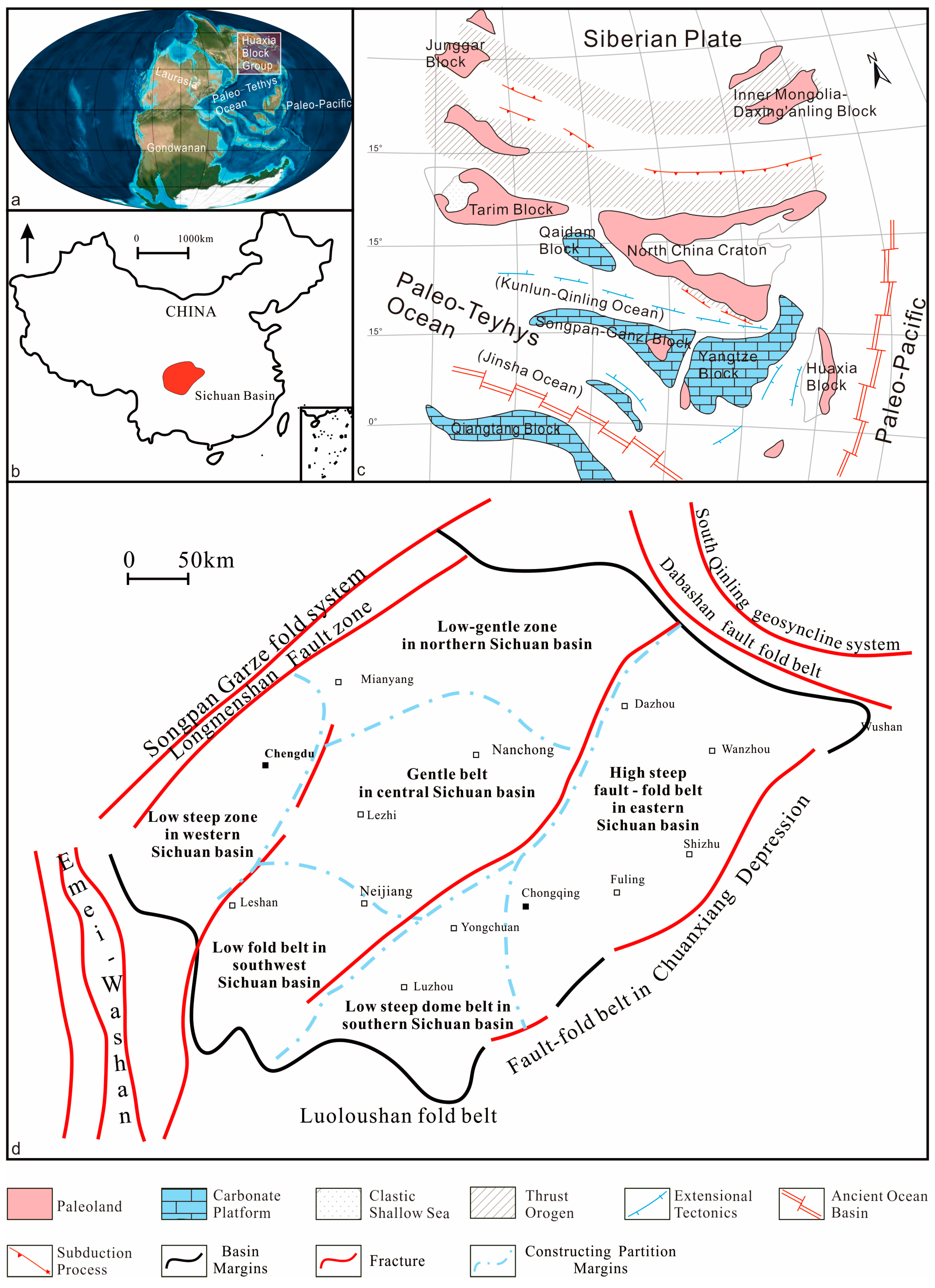
2.1. Geological Location and Tectonics

The Sichuan Basin, spanning an approximate area of 18 × 104 km2, represents the primary oil-and-gas-bearing basin in western China [16]. Geologically, it lies in the northwest of the Yangtze Block, bordered by the Songpan–Ganzi Fold Belt and Longmenshan Thrust Belt on the eastern edge of the Qinghai-Tibet Plateau to the west. To the north, it is bounded by the Micang Mountain Dome and Daba Mountain Thrust Belt, situated on the southern edge of the Qinling Orogenic Belt. The eastern periphery is marked by the Xuefeng Uplift and the Guizhou–Chongqing–Hunan–Hubei Fold Belt, which belong to the outer edge of the South China Orogenic Belt. The Sichuan Basin assumes a rhombic shape, with its long axis oriented in the northeast direction [18].
Before the Permian deposition, the entire Sichuan Basin underwent uplift and weathering as a consequence of the Caledonian Movement [6]. This led to varying degree of stratigraphic erosion, resulting in the absence of Middle and Upper Silurian, Devonian, and Carboniferous strata (Figure 1). In general, the ancient landform configuration exhibited high terrain in the southwest and lower terrain in the northeast [19,20]. The Sichuan Basin underwent an evolution as an epicontinental basin from the Devonian to the Middle Triassic. Subsequently, during the Early Permian, it endured a substantial phase of exposure and erosion. Consequently, Lower Permian strata are absent throughout the Sichuan Basin and its neighboring areas [21,22,23]. Following this prolonged period of sedimentary discontinuity, a large-scale marine transgression occurred during the early Middle Permian. The initial uplift and erosion zones were completely submerged, resulting in the Middle Permian overlaying the Carboniferous, Silurian, Ordovician, and Cambrian strata. This succession encompassed a sequence ranging from clastic rocks with interactive coal-bearing components to marine carbonate rocks [24]. Towards the end of the sedimentation period of the Maokou Formation, the Dongwu Movement triggered a sustained tectonic uplift of 1–1.5 million years in the basin, leading to the formation of a southward-dipping uplift and erosion zone along the Kaijiang–Dazhou region [25].

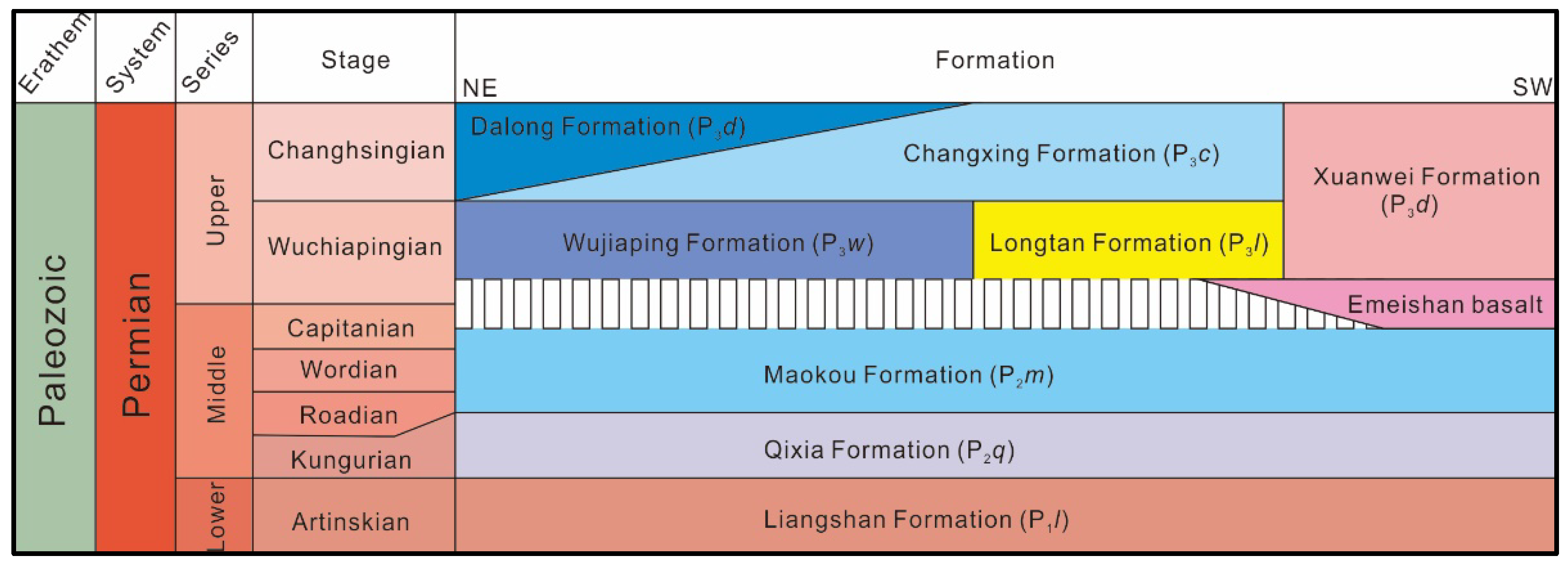
2.2. Stratigraphy and Sedimentary Environment

During the Late Permian, the Dongwu Movement exerted an influence on the Sichuan Basin, leading to the erosion of the Maokou Formation [3,9]. The eruption of the Emeishan basalt primarily occurred between the Maokou and Wujiaping stages, resulting in a brief sedimentary hiatus and a shortened period of uplift and erosion for the Maokou Formation. The erosion of the Maokou Formation, along with the constraints imposed by the Wujiaping Formation, suggests that prior to the Emeishan basalt eruption, a rapid crustal uplift formed a significant dome uplift [7,9]. Consequently, the structural pattern of the Sichuan Basin exhibits higher elevations in the southwest and lower elevations in the northeast [10,26]. Owing to variations in tectonic patterns, sedimentary facies within different regions during the same period display substantial differences, ranging from river delta facies to deep-water shelf facies [21,25]. The southeastern and central regions are characterized by an extensive development of swamp and lagoon sedimentary environments [27].
Figure 1. (a) Global paleogeographic reconstruction during the Middle–Late Permian [5]; (b) location of Sichuan Basin [7]; (c) structural position of the Yangtze Block during the Middle–Late Permian and its relationships with surrounding plates [8]; (d) structural zoning of Sichuan Basin [28,29].
Minerals 13 01406 g001
In the Sichuan Basin, the Lower Permian includes the Liangshan Formation, the Middle Permian comprises the Qixia Formation and Maokou Formation, while the Upper Permian includes the Longtan/Wujiaping Formation and Changxing/Dalong Formation (Figure 2). The Liangshan Formation predominantly consists of tidal flat and coastal swamp facies, with thickness ranging from several meters to tens of meters, exhibiting a gradual thinning trend from the basin periphery to the interior. During the sedimentation period of the Qixia Formation and Maokou Formation, the Sichuan Basin experienced open platform sedimentation, with certain regions featuring intra-platform shoals. Notably, the Qixia Formation exhibits relatively thick strata, often exceeding 100 m, while the Emeishan basalt is situated between the Middle and Upper Permian strata [8,15,19].
The Dongwu Movement, occurring towards the end of the Middle Permian, brought about comprehensive uplift and erosion across the Sichuan Basin. The sedimentary environment of the Late Permian underwent substantial complexity and significant changes compared to the Middle Permian [13,20]. Overall, as the paleogeographic pattern transitions from land to sea in a southwest-to-northeast direction, the sedimentary facies of the Longtan/Wujiaping Formation exhibits a transition from river swamp facies and nearshore lake basin/delta facies to shallow continental shelf facies, or from bay lagoon facies/deep gentle slope detention marine facies to open platform facies and continental shelf facies (basin facies) [16]. During the sedimentary period of the Changxing Formation, the Sichuan Basin primarily featured open platform facies, whereas the eastern Sichuan region witnessed deep-water sedimentation characterized by trough/basin facies, namely the Dalong Formation [13].

3. Materials and Methods

This study employed comprehensive methods including detailed field profile observations and the identification of micro fossils in thin sections to investigate the Permian strata within the Sichuan Basin. Within the confines of this study, we meticulously scrutinized Permian strata across diverse regions of the Sichuan Basin. A grand total of 10 field profiles were thoroughly investigated, from which 193 rock samples were meticulously collected. Moreover, we executed drilling analyses on 23 boreholes situated within the Permian strata of the basin.
Sedimentary facies refer to the similarity and consistency exhibited by various sediment properties, composition, and structure within a specific time and space range [26,30]. By closely examining the profiles and rock samples from corresponding strata in areas such as Guangyuan and Jiange, factors such as color, lithology, texture, composition, and structure were analyzed to preliminarily determine the sedimentary facies types. Additionally, the characteristics of fossil assemblages were used to classify and qualitatively determine the paleoecological environment and sedimentary facies types in the region. Furthermore, rock physical parameters obtained from logging data, such as density (DEN), acoustic velocity (AC), and natural gamma (GR), were integrated to infer the type and thickness of sediment, thereby validating the results of field observations and accurately classifying sedimentary facies. Finally, based on the acquired information, a comprehensive analysis was conducted to determine the sedimentary facies types in the study area. Moreover, by combining the logging data, the thickness, dip angle, distribution, and other important information regarding the strata were inferred to facilitate paleogeographic reconstruction.

4. Results

4.1. Facies Analysis

Through the identification and analysis of rock samples and thin sections, eight macroscopic facies and fourteen microfacies were identified and described from the sections on the matrix type, particle composition, and structural characteristics of the rocks [21,23,26].

4.1.1. Color Indicators

The color of rocks can provide insights into the hydrodynamic state of sedimentary environments to a certain extent [25]. Lighter-colored rocks may indicate local highlands with strong hydrodynamic forces. These sedimentary rocks, having undergone significant erosion, contain less mud, resulting in lighter-colored rock types. Conversely, darker-colored rocks are indicative of deeper water environments with weaker hydrodynamic forces or confined settings. In these sedimentary rocks, the higher content of mud contributes to their darker coloration. The predominant lithological characteristics of the Qixia Formation in the study area are mainly gray and dark gray (Figure 3a–c), while the Maokou Formation exhibits predominantly gray and light gray colors (Figure 3d–f). The overall variation in rock color reveals the contrasting sedimentary environments of the Middle Permian Qixia Formation and Maokou Formation within the basin, which aligns well with the patterns identified by other facies indicators.

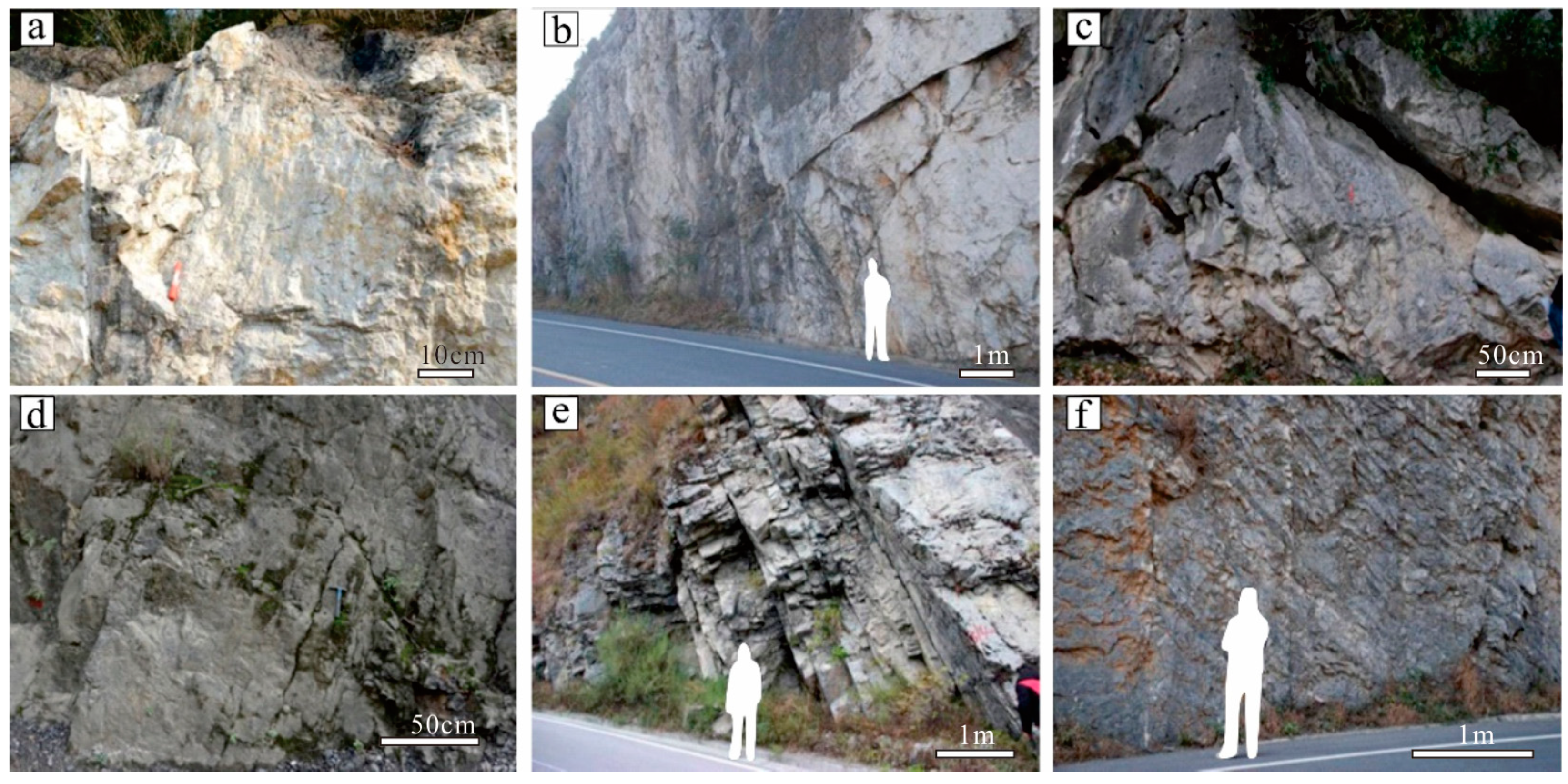
4.1.2. Lithological Indicators

The rock type serves as a crucial lithofacies indicator in distinguishing different sedimentary environments [5,14]. Certain distinctive rock types can provide insights into the water energy conditions, hydrochemical environments, and climatic characteristics during rock deposition, thereby indicating specific sedimentary facies types. Carbonates vary significantly, and they are indicative for not only shallow but also for deep water facies, depending on a number of parameters [2,4]. Usually, expansive and stable carbonate rocks are typically associated with warm coastal shallow waters, while gravel structures signify highly energetic environments. Siliceous and muddy rocks, enriched with organic matter, form in deeper water bodies or stagnant reducing environments. The presence of gypsum and various salts indicates arid climatic conditions, among other indicators [12,20].
Through a comprehensive analysis of individual well data and field profiles within the Sichuan Basin, it was observed that the Permian system primarily consists of distinct rock types, including micrite bioclast limestone, sparry bioclastic limestone, sparry oolitic limestone, and crystalline dolomite (Figure 4). Each of these rock type bears significant indicative value concerning the sub-environments of carbonate rocks.

4.1.3. Sedimentary Structures

Sedimentary structures refer to macroscopic features that arise from the heterogeneity in the composition, structure, color, and other characteristics of sediments [16,31,32,33].
At the Ebian Maoping section, ripple marks can be observed, while parallel bedding is present in the Hanshen-1 well. Ripple marks reflect a depositional environment characterized by strong wave action in a nearshore area, indicating a relatively intense wave-dominated shallow marine environment. Parallel bedding, on the other hand, indicates a depositional environment with strong hydrodynamic conditions in a nearshore setting. Additionally, other types of sedimentary structures, such as synsedimentary structures and erosional surfaces, can also be observed.

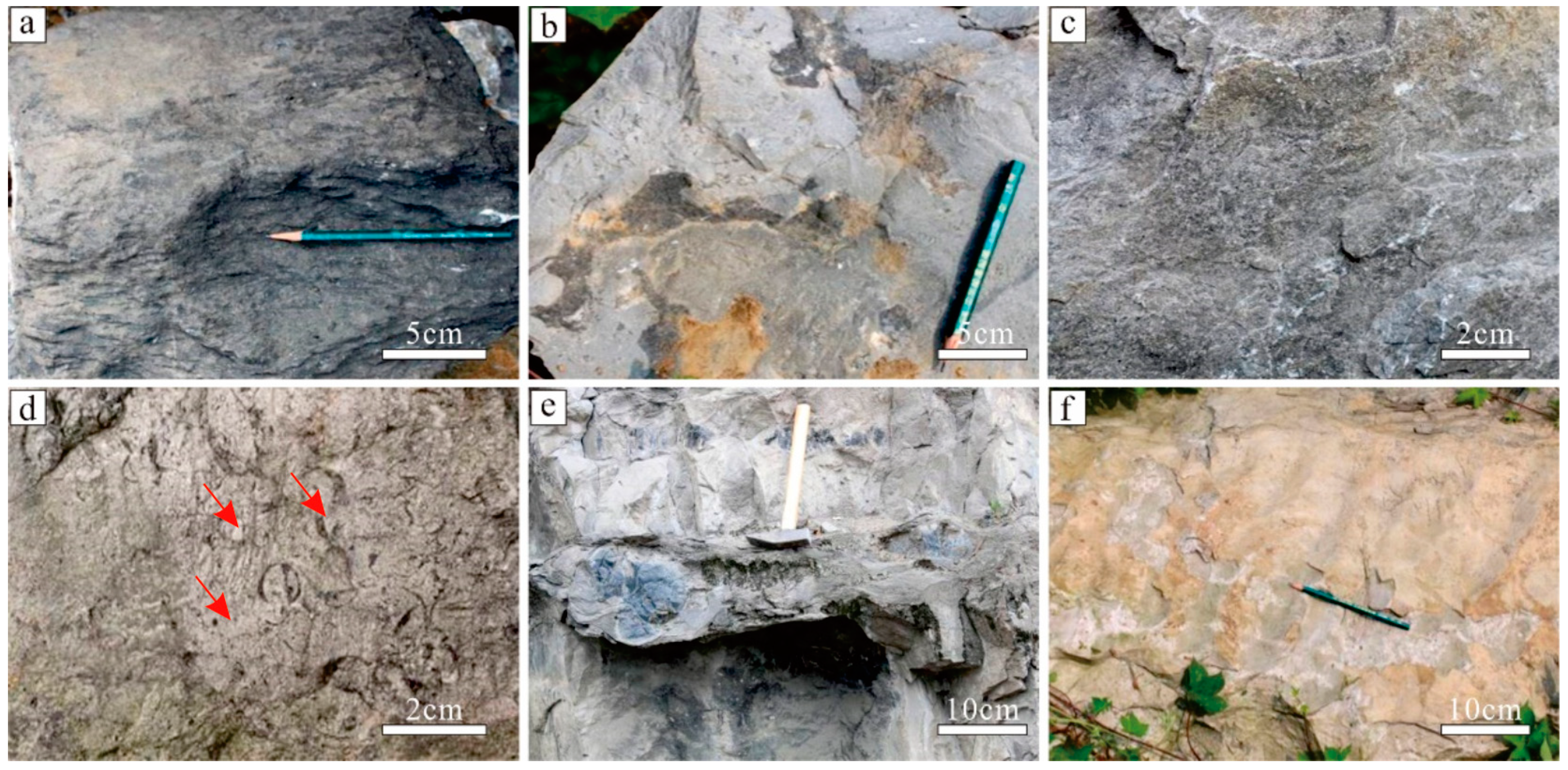
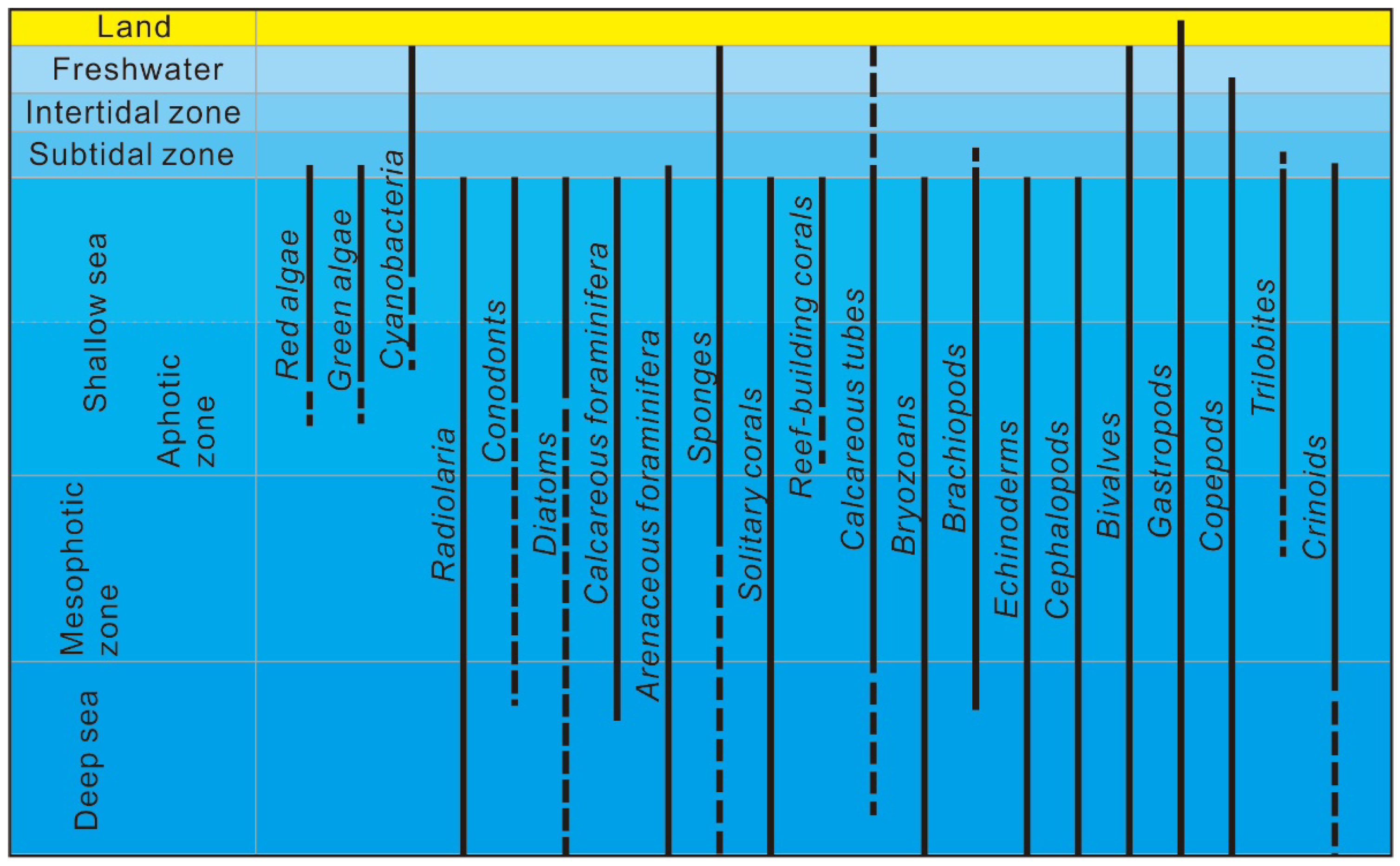
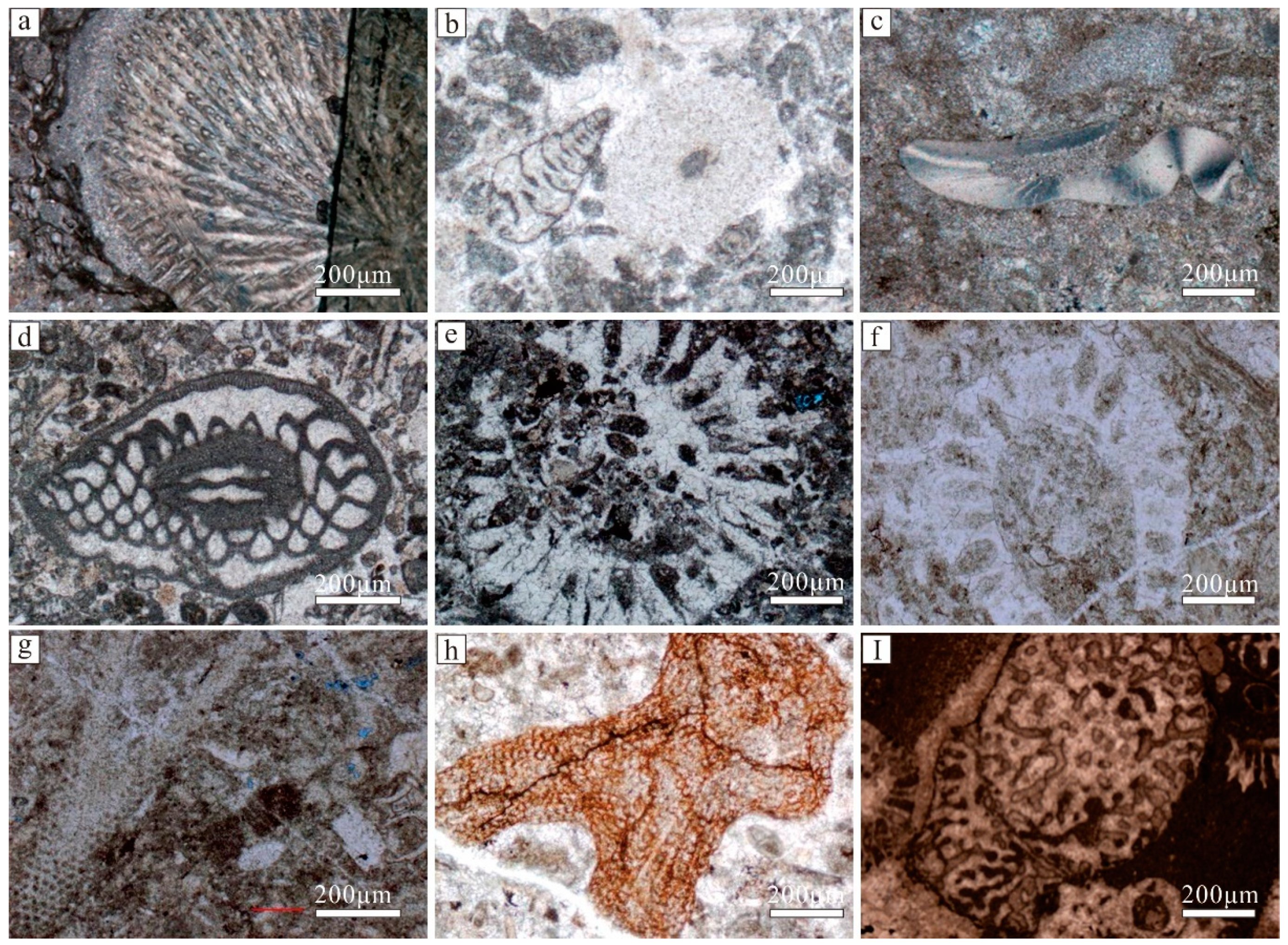
4.1.4. Palaeontologic Indicators

The relationship between organisms and their living environment is inseparable. Through the observation of modern sedimentary environments, it is evident that different organisms can only adapt to specific conditions. Therefore, by examining the paleoecological features, we can infer the living environments of organisms and conduct sedimentary environment analyses (Figure 5).
In the Permian system of the Sichuan Basin, a wide range of ancient organisms can be found. These include green algae and red algae, which are typical of shallow marine environments, as well as reef-building organisms such as sponges and corals. Additionally, there are diverse distributions of organisms such as brachiopods, foraminifera, radiolarians, crinoids, and spines (Figure 6). The varied types of ancient organisms collectively indicate an environment characterized by shallow water, ample oxygen, and normal salinity.

4.1.5. Logging Curve Characteristic Indicators

Logging data is one of the important indicators for determining sedimentary environments, and different logging response patterns correspond to different sedimentary microfacies. The characteristics of logging response curves include the magnitude of anomalies, smoothness, convergence of teeth lines, curve shapes, and top–bottom contact relationships. These characteristics reflect various aspects of lithology, grain size, mud content, and vertical variations. The logging characteristics associated with different sedimentary microfacies also exhibit differences.
In the study area, the predominant sedimentary facies are characterized by open-platform subfacies. Shallow shoal microfacies within the platform show lower and jagged patterns on the GR curve due to their low mud content, while the resistivity curve displays higher jagged patterns. In contrast, open-sea microfacies, with a higher mud content, exhibit completely different logging responses compared to shallow shoal microfacies. Therefore, by combining the GR and RT curves, the microfacies types can be inferred based on the curve patterns. For example, a bell-shaped curve with finer grains at the top and coarser grains at the bottom represents an upward transition from open-sea microfacies to shallow shoal microfacies in the sedimentary facies combination (Figure 7). The stacking of multiple bell-shaped curves represents variations in facies associations during multiple cycles. Distinct differences in logging responses are also observed for different microfacies within the margin of the platform, such as biogenic reefs in the Kaijiang–Liangping trough. Through the analysis of logging response curves in drilling wells of biogenic reefs in the Kaijiang–Liangping trough’s western side, it was found that these reefs exhibit distinct electrical characteristics, and there are significant differences in the electrical characteristics among the different microfacies. Taking the Longgang 82 well as an example (Figure 7), the electrical characteristics of the different microfacies are as follows: the reef core exhibits thick-layer electrical characteristics, with lower natural gamma ray values and straight sonic transit time curves, while the reef base and reef flat display higher natural gamma ray and resistivity values, with relatively fluctuating sonic transit time curves.

4.2. Division of Sedimentary Facies

Based on previous studies [1,24,25,26,27,30] on the Permian sedimentation in the Sichuan Basin, field observations from outcrop measurements and relevant drilling core examinations, and the integration of well logging data, we conducted a detailed subdivision of the Permian facies in the Sichuan Basin. This subdivision encompasses various sedimentary facies and subfacies types based on criteria such as lithology, sedimentary structures, fossil assemblages, and well logging response patterns. The comprehensive classification is presented in Table 1.

4.3. Characteristics of Different Sedimentary Facies

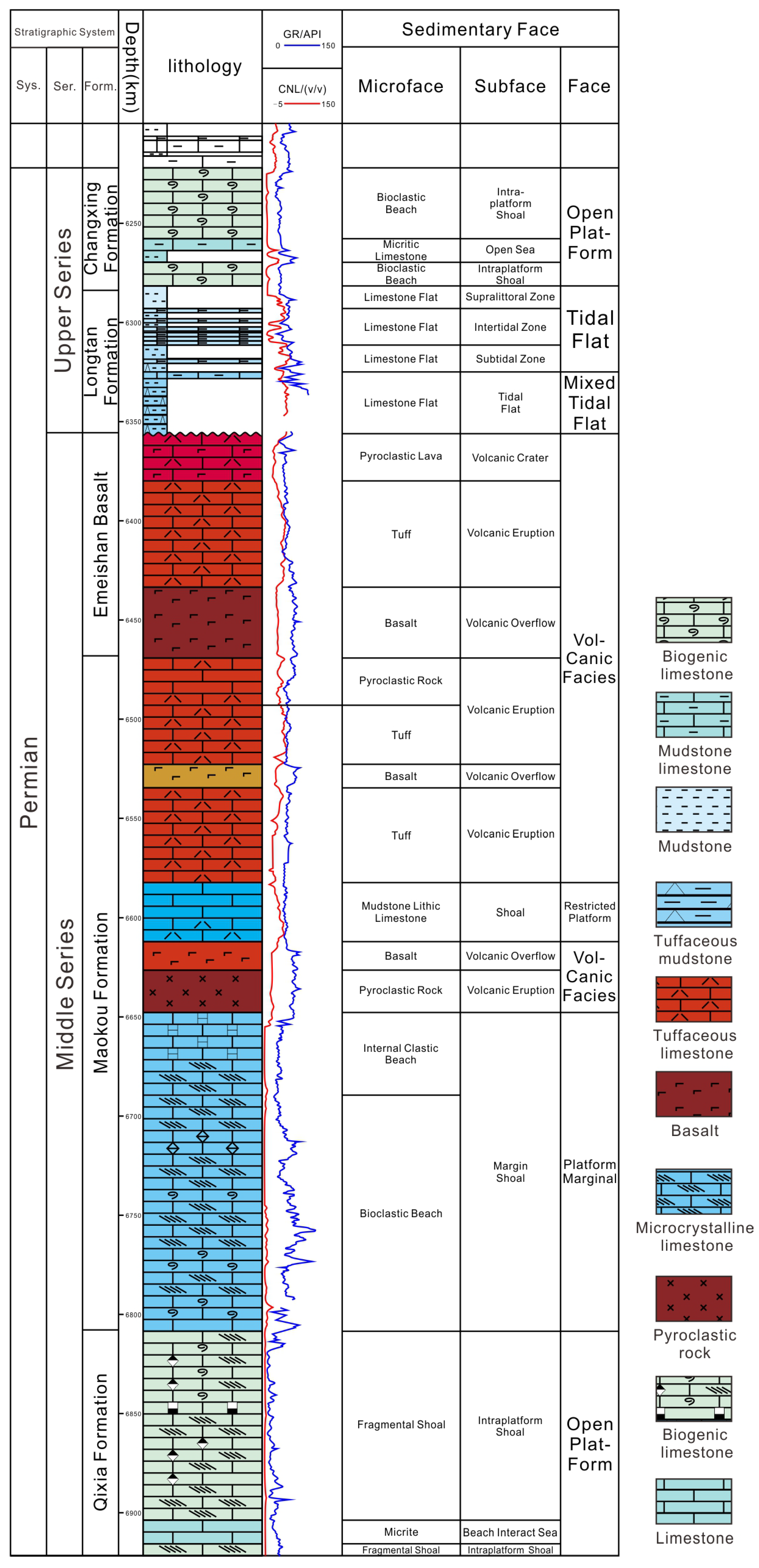
4.3.1. Mixed Tidal Flat

The mixed tidal flats are distributed near the Kangdian Paleo-land and are predominantly developed in the lower part of the Qixia Formation, Maokou Formation, and Longtan Formation within the study area. The mixed tidal flats represent depositional facies formed by the mixing of terrigenous clastics and carbonate sediments. Compared to the restricted platform tidal flats, the mixed tidal flats exhibit a higher input of terrigenous materials, resulting in a higher proportion of sandy components in the sediment [34,35,36]. In some cases, the sediment can even form relatively pure quartz sandstones. Based on variations in sediment characteristics, the mixed tidal flats can be further subdivided into two subfacies: tidal flats and sand bars (Figure 8).

4.3.2. Tidal Flat

Tidal flats are distributed in the coastal areas surrounding the lagoon, influenced by tidal action or storms. They exhibit lensoidal, vein-like, and ripple bedding structures, with gully structures developed within the bedding planes [34,35,36]. Due to frequent exposure in the supratidal zone, common features such as desiccation cracks and raindrop imprints are observed. The tidal flats can be further classified into the supratidal zone, the intertidal zone, and the subtidal zone, primarily developed in localized areas influenced by the Kangdian Paleo-land, including the Qixia Formation, Maokou Formation, and Longtan Formation (Figure 8).

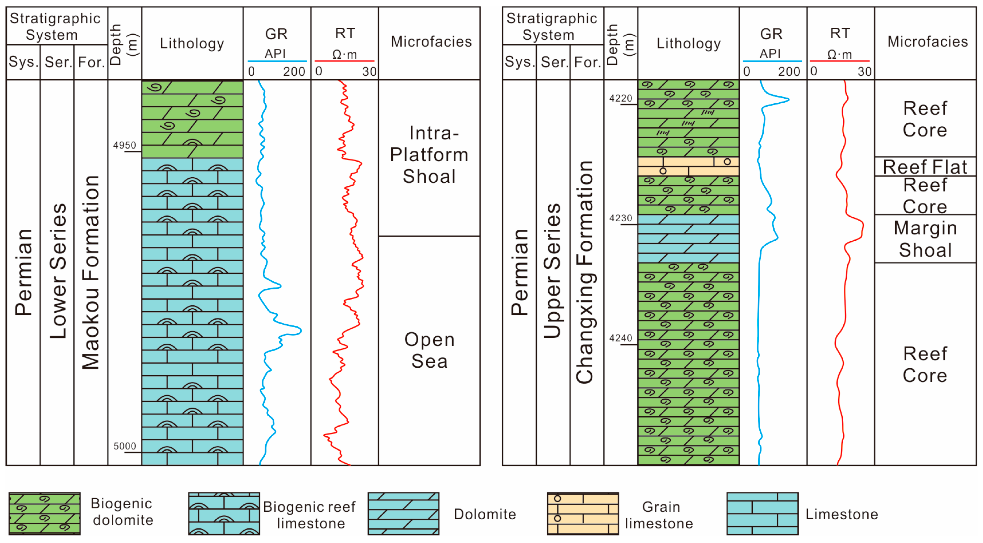
4.3.3. Restricted Platform

Restricted platform facies generally exhibit limited water circulation, lower overall water energy, and significant salinity fluctuations compared to the open platform facies. Biological diversity in restricted platform facies is typically low and characterized by a limited range of species, predominantly including cyanobacteria, foraminifera, and brachiopods, with noticeable bioturbation [22,29]. The lithology is primarily composed of limestone, dolomitic limestone, dolomitic limestone interbedded with algal laminations, and mudstone. Various tidal bedding structures, such as lensoidal, vein-like, and ripple bedding, are developed. During the Permian Qixia and Maokou periods, restricted platforms were predominantly distributed in the northern and eastern parts of the Kangdian Paleo-land as relatively confined areas. Based on the hydrodynamic conditions and variations in topography, the restricted platform can be further subdivided into sub-environments such as lagoons and shoals (Figure 8).

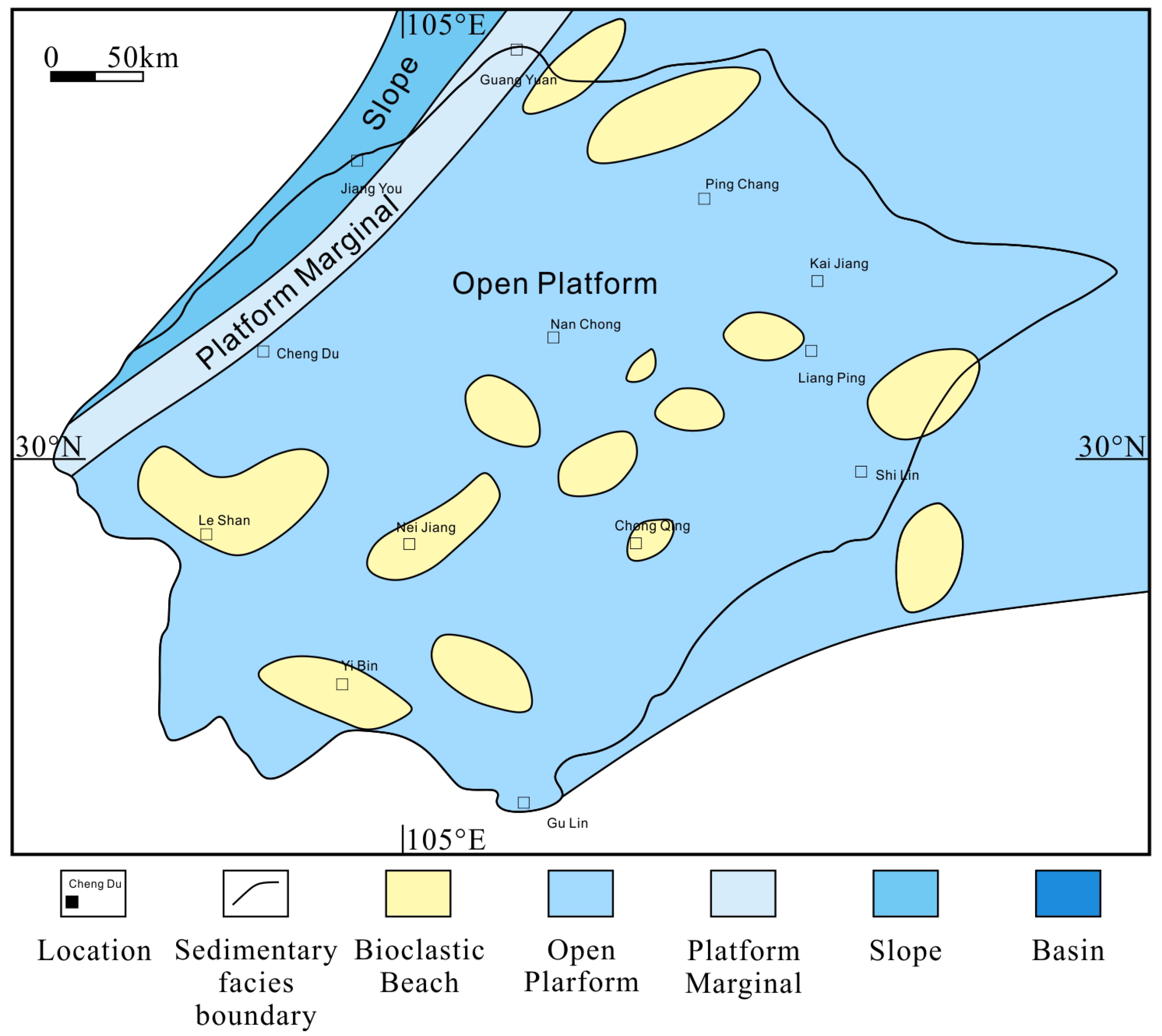
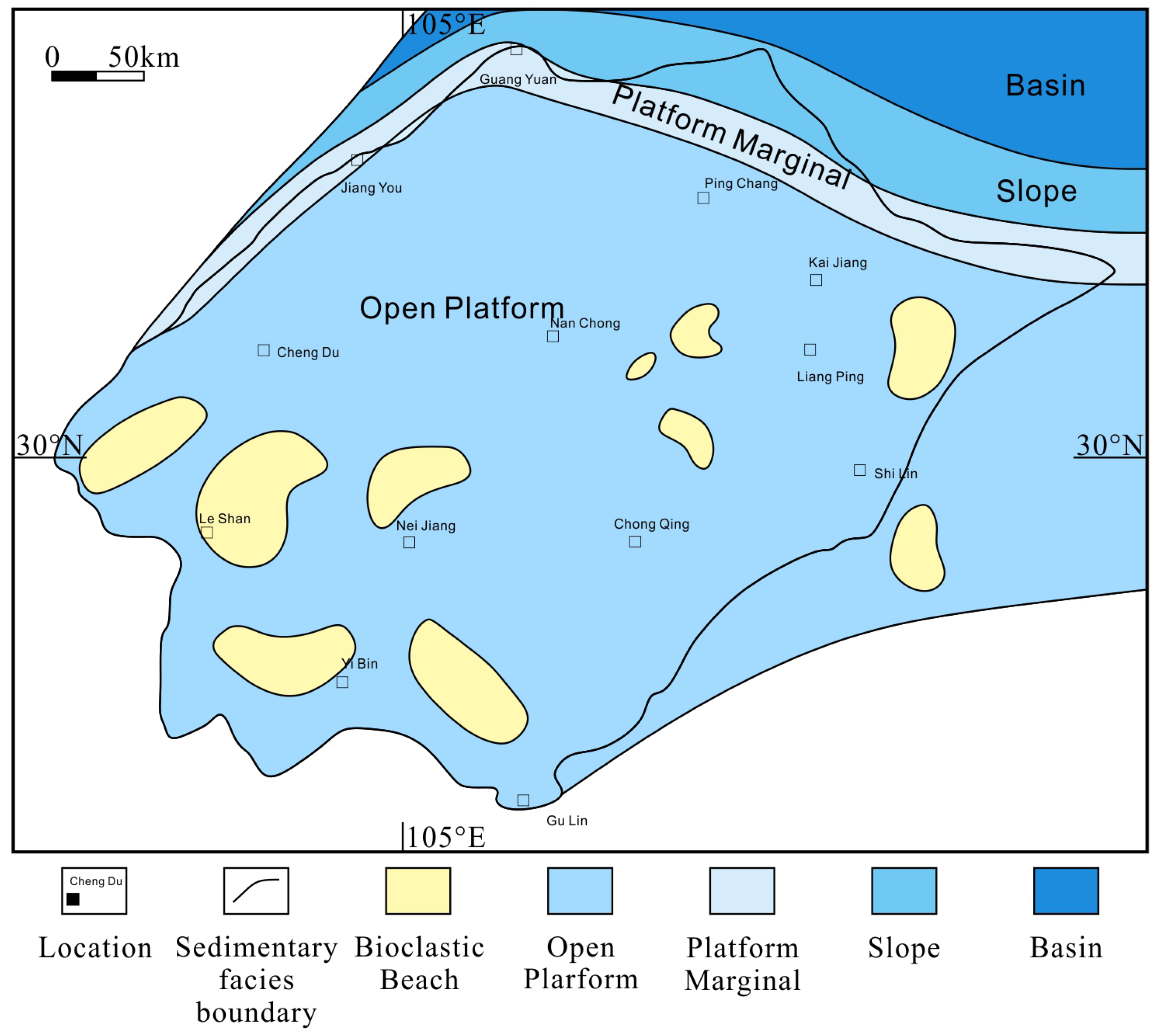
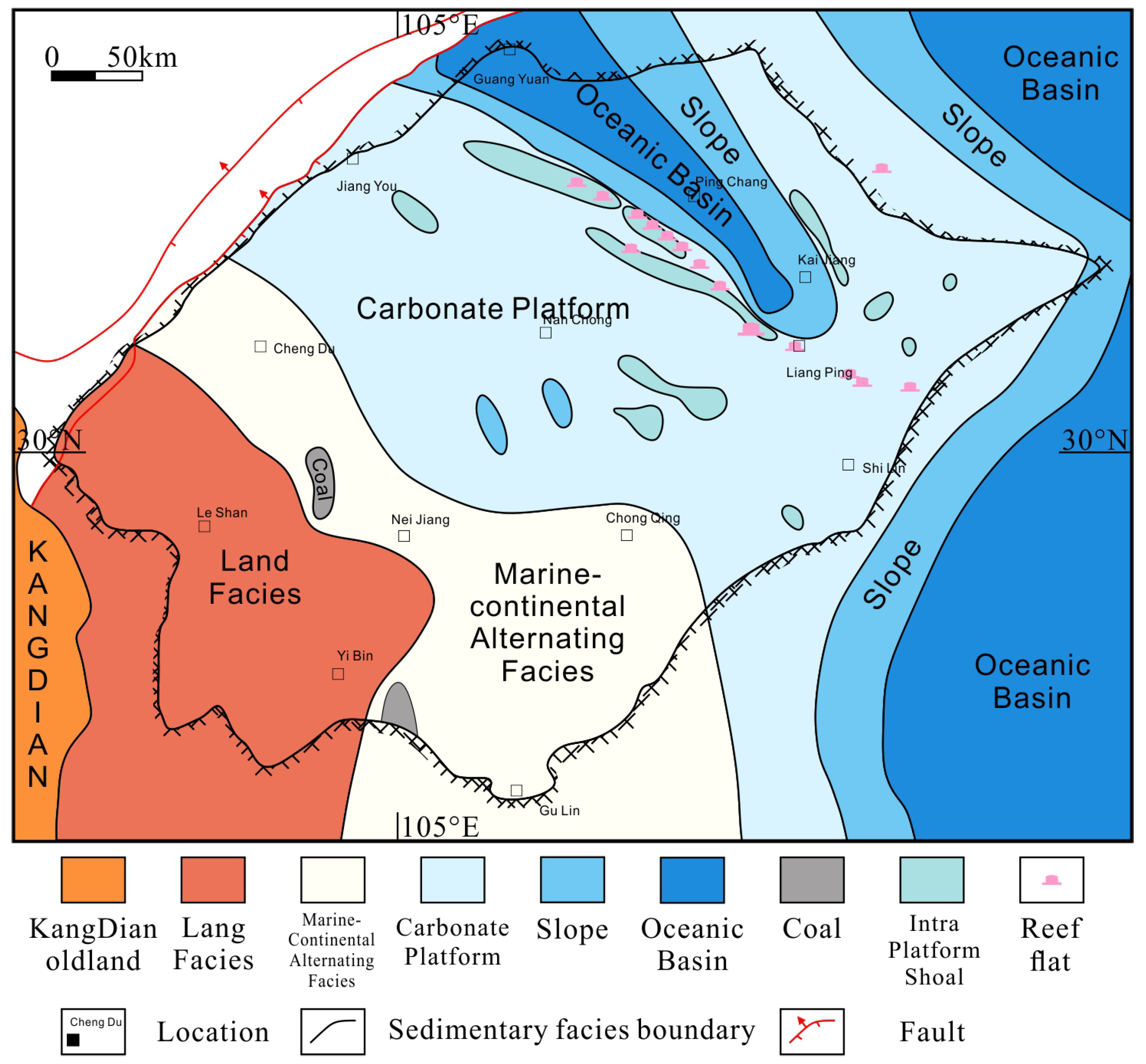
4.3.4. Open Platform

Open platform facies are generally located on the seaward side of the platform, often between the platform margin and the restricted platform, separated from the open sea by underwater uplifts [23,26]. They are characterized by a broad marine area, relatively flat seafloor topography, well-developed water circulation, normal salinity levels, and water depths ranging from a few meters to tens of meters. The sediment primarily consists of particles and pelagic mud. The particles mainly include bioclasts such as red algae, green algae, brachiopods, cephalopods, foraminifera, and sand grains. The composition of pelagic mud exhibits significant variations and shows an inverse relationship with the particle content, often appearing as cement and matrix components. The main rock types include peloidal (mud) bioclastic limestone, peloidal (mud) algal limestone, oolitic limestone, peloidal sand-clastic limestone, bioclastic (mud) peloidal limestone, and locally developed intraplatform reef limestone. The “oolites” in the oolitic limestone are composed of bioclastic peloidal limestone. Open platform facies are widely distributed in the study area and are developed in various Permian stratigraphic units. They are predominantly characterized by the deposition of peloidal mudstone, algal limestone, and bioclastic limestone, with minor occurrences of peloidal bioclastic limestone, peloidal red algae limestone, sand-clastic limestone, and dolomite. Based on the topographic variation within the platform and the energy level of the depositional water, the open platform can be further divided into intraplatform (reef) shoals and open sea environments (Figure 8).

4.3.5. Platform Margin

The platform margin reef and shoal facies are well developed in the Changxing Formation within the study area [15,19,37]. This is evident from field outcrops, well cores, and seismic profiles, as clearly shown in Figure 8.
1. Bioherms at the margin of the platform
The bioherms at the margin of the platform are distributed on the plane along the platform edge, occurring in clusters or as linear features, with individual reef bodies exhibiting a dome-shaped pinnacle morphology. The reef-building organisms include sponges, bryozoans, and hydroids, most of which possess a skeletal framework, while some exhibit disordered arrangements. The reefs display a skeletal framework structure with interstitial filling of mud and particles. They consist of distinct units, including the reef base, reef core, reef crest, and reef cap. The reef base and inter-reef areas are composed of bioclastic limestone, while the reef cap is composed of dolomite. Four types of reefs are identified, namely skeletal reefs, barrier reefs, cemented reefs, and mud mounds.
2. Shoal at the margin of the platform
The shoal at the margin of the platform is characterized by well-sorted carbonate clastic debris and other particles, forming carbonate rock bodies. It is found in the Changxing Formation and Feixianguan Formation, observed in profiles such as Panlongdong in Xuanhan. In the plan view, it is distributed along the margin of the platform, indicating high energy during deposition. It is predominantly composed of well-crystalline oolitic limestone and well-crystalline sand-clastic limestone, exhibiting large-to-medium-scale cross-bedding, wedge-shaped cross-stratification, and disturbed structures. It is often associated with bioherms. Due to a subsequent sea-level drop, the shallow shoals are prone to exposure, leading to pervasive dolomitization of the rocks. Microfacies such as oolitic grainstone, sand-grainstone, and bioclastic grainstone are developed. In the stratigraphic sequence, the grainstone lithologies commonly occur in an upward shallowing depositional trend along with mudstone dolomite.

4.3.6. Slope

The slope depositional system is a sedimentary system that develops on a relatively homogeneous gentle slope within a carbonate sedimentary background. In the Sichuan Basin, the Changxing Formation–Feixianguan Formation slope represents a typical example of a gentle and homogeneous slope, without distinct slope breaks between the carbonate platform and the continental shelf. Compared to the steep slopes at the margin of the rimmed platform, the gentle slope lacks large-scale gravity flow deposits such as debris flows and turbidites and is characterized by fine-grained sedimentation. The lithology is dominated by dark-gray thinly bedded laminated limestone and nodular limestone. Occasional slumping events can occur due to factors such as storms and earthquakes, resulting in the presence of carbonate debris flows and calcirudites in the rocks.

4.3.7. Basin

Sedimentation in the basin primarily occurs in the Late Permian Dalong Formation, located along the margins of the northwestern, northern, and northeastern parts of the Sichuan Basin. The rock types consist mainly of thinly to moderately bedded chert, chert-bearing limestone, chert band (block) limestone, bioclastic limestone, and carbonaceous shale. The sediment thickness is relatively small, indicating underfilled basin sedimentation. Planktonic ammonoids (pseudotriassic ammonoids, parafusulines), radiolarians, deep-water sponge spicules, and small brachiopods are common fossils found in the basin. The basin facies can be divided into shallow marine and deep marine subfacies, with the shallow marine facies being predominant in the region. The basin is located in a relatively low-lying area on the outer shelf, with water depths of approximately 200 m or less. Bottom currents are not well developed, and the environment is often characterized by semi-stagnant and weakly reducing conditions.

4.3.8. Volcanic Facies

During the late Maokou Formation, influenced by the upwelling of the Emei mantle plume and Emei tectonic rifting, magma erupted along deep major faults and reached the surface [4,30,31]. Lava flows flowed from southwest to northeast, forming the Emeishan Large Igneous Province in the Yunnan–Guizhou–Sichuan region. Based on lithological characteristics and previous research findings, the Permian volcanic rocks in the Sichuan Basin exhibit eruption, overflow, and volcanic conduit facies. Among them, the volcanic conduit facies can be further divided into central-type and fissure-type, with the primary microfacies being volcanic breccia lava. The explosive facies consists of volcaniclastic rocks and tuff. The overflow facies is composed of basalt.

5. Discussion

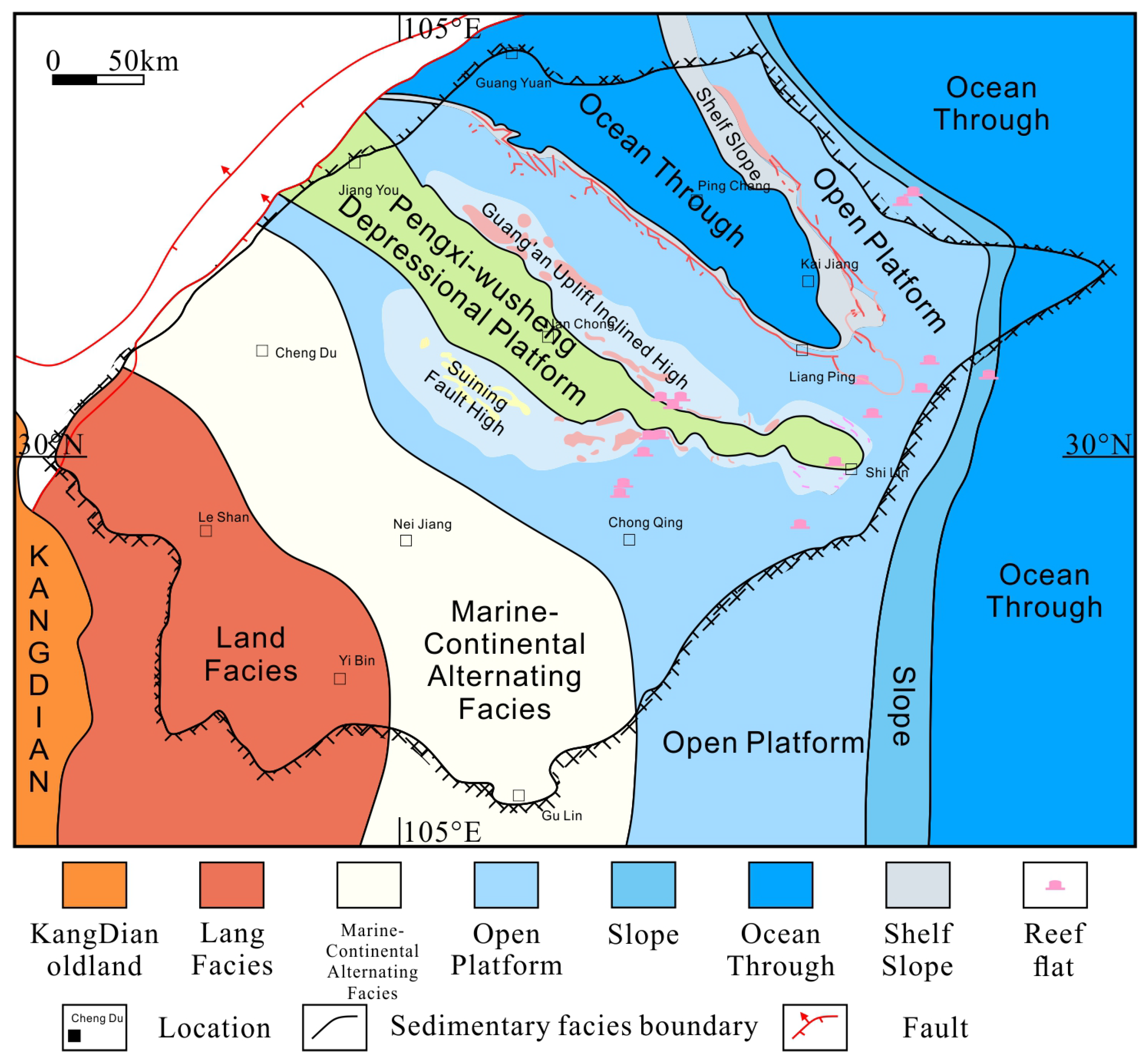
5.1. Early-Middle Permian Lithofacies Paleogeography

The Late Silurian Hercynian orogeny occurred at the end of the Silurian period, resulting in the formation of two major uplifts in the Upper Yangtze Platform of China [1,15,18]. The northern uplift is known as the Leshan–Longnvsi ancient uplift, while the southern uplift is referred to as the central Guizhou ancient uplift [12,33]. These uplift events caused varying degrees of erosion on the strata above the Cambrian, with the Devonian and Carboniferous systems being restricted to the periphery of the ancient uplifts. The Lower Permian strata are predominantly distributed in southern Guizhou, with some remnants of the lower part of the Zisong stage found in the northern segment of the Longmen Mountains. After prolonged weathering and erosion, the Middle Permian sediments were deposited on different substrates.
During the Middle Permian, widespread marine transgressions occurred in the study area. The seawater originated from the ancient Pacific Ocean in the east and the ancient Tethys Sea in the west. Several continental islands, such as the Kangdian ancient land and Motianling ancient land, were developed in the region. Along the periphery of these ancient lands, mixed tidal flats were formed. Limited marine sedimentation occurred in the Mianyang, Dujiangyan, and Baoxing areas, while multiple shoal deposits were locally developed. In the northeast of Anxian, there is a long, northeast-trending belt of platform-margin shoals. To the west, the West Sichuan Trough was formed, and to the north, the Guangwang Platform Basin developed. In the extensive regions of central, eastern, and southern Sichuan, during the Early Liangshan stage, they were characterized by coastal swamps. A sedimentary sequence consisting of variegated mudstone and black shale interbedded with limestone, dolomite, sandstone, siltstone, mudstone, and coal seams was deposited. During the Qixia and Maokou stages, marine transgressions occurred, resulting in the deposition of open platform and basin sediments. These sediments consist of mudstone, mudstone with intraclasts, black chert, and shale. Within the areas of Weiyuan, Nanchong, Daxian, Bazhong, and Lichuan, multiple shallow shoal deposits within the platform were developed (Figure 9 and Figure 10).

5.2. Late Permian Lithofacies Paleogeography

During the Late Permian, the Dongwu Movement occurred, resulting in the uplift of the Upper Yangtze Platform and erosion of the Maokou Formation to varying degrees. In most areas of the oil and gas region, the equivalent of the Lengwuan Stage is missing, and in some areas, only the lower part of the Maokou Stage is preserved. The Dongwu Movement also caused crustal rifting and extension, leading to the eruption of basic basaltic magma. The eruption center is located along the deep-seated fault zone of the Sichuan–Yunnan–Guizhou uplift, with a maximum thickness exceeding 2800 m and with a distribution area of 30 × 104 km2. Basaltic rocks are mainly distributed in the southwest of Sichuan and also occur in the northeast of Sichuan. Under its influence, the lithofacies of the Late Permian show significant differentiation and exhibit a southwest-to-northeast trend. Compared to the distribution of lithofacies in the Middle Permian, the Late Permian lithofacies belt is relatively narrower, and the lithofacies change rapidly in the plan view, indicating a significant north-northeastward inclination of the Late Permian sedimentary basement.
During the Longtan Stage, the Emei region experienced the Emei rift movement and uplift due to the Dongwu Movement, causing the retreat of seawater to the east. A sag basin formed in the southwest of the study area, resulting in the eruption of basaltic magma. During this stage, extensive volcanic eruptions and fluvio-lacustrine deposits developed east of the Kangdian ancient land. The depositional facies belt migrated from west to east, with the development of coastal tidal flats and coastal swamps. The predominant sedimentary lithologies include sandstone–mudstone–coal sequences, chert nodules, and mud-crystal limestone deposits associated with river-lake alluvial plains, marshes, and tidal flat facies. To the north, volcanic submarine eruption facies developed (Figure 11).
During the Changxing Stage, a large-scale transgression occurred. The central and eastern parts of the study area mainly comprised open plateaus, while the Anxian–Daxian area represented the marginal slope of the platform. These regions mainly deposited a lithostratigraphic sequence of mud-crystal limestone, bone debris limestone, and calcareous shale with chert nodules. Along the marginal slope, multiple biogenic reef shoals developed in Cangxi–Daxian and Lichuan. In the eastern part of the study area, the Chengkou–Exi trough formed, while the northern part consisted of the Chuanxi trough and continental shelf (Figure 12 and Figure 13).

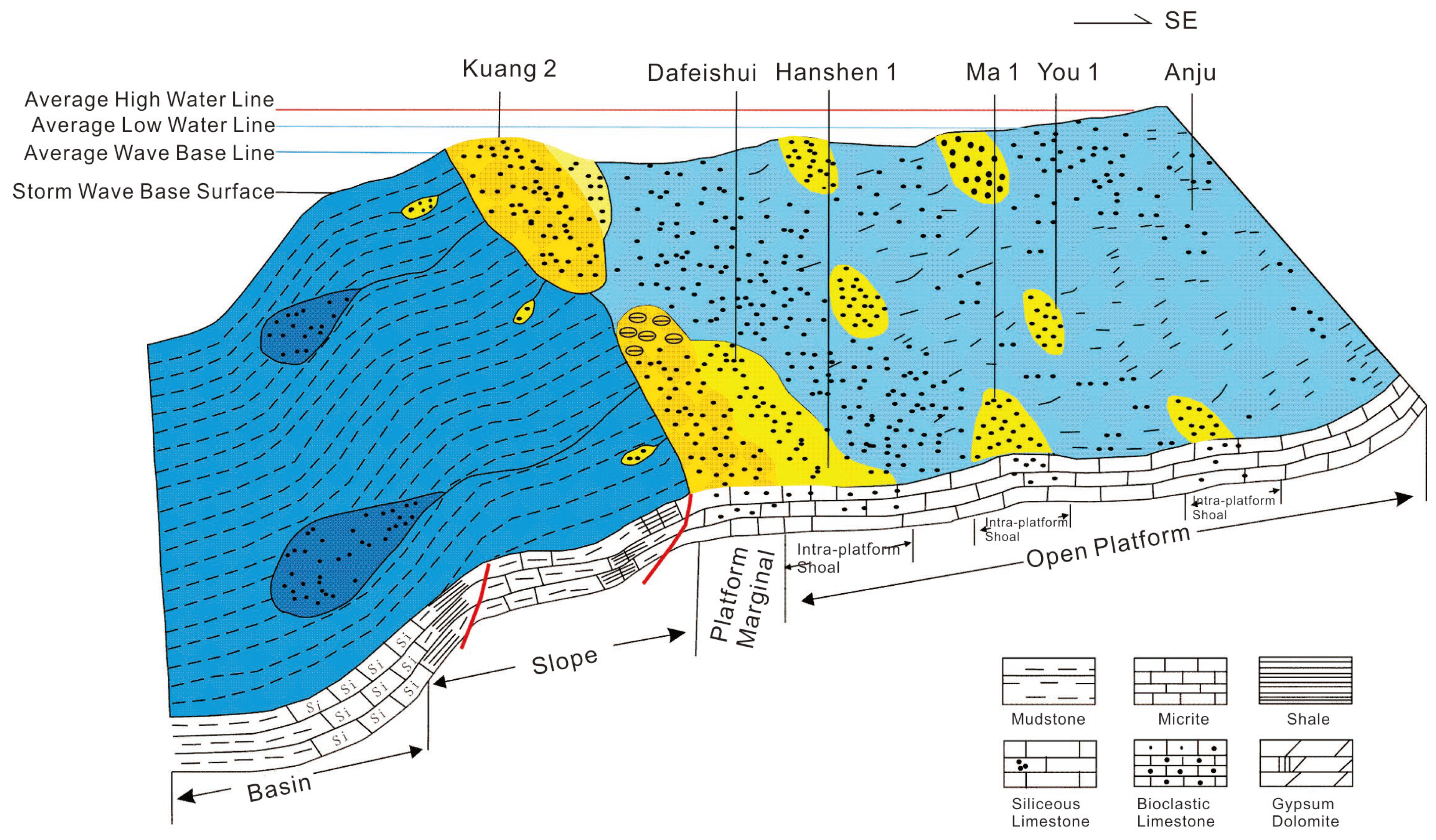
5.3. Depositional Models

Following the Indosinian orogeny, the crust exhibited significant differential uplift and subsidence. The Indosinian orogeny resulted in extensive erosion in most parts of Sichuan, with increasing erosion intensity from east to west. To the west of the Sichuan craton lies the Longmenshan island arc, while the Kangdian ancient land is distributed in the southwest. Between the craton and the island arc, a sag basin controlled by the Longmenshan fault system accumulated thick deposits of Devonian to Carboniferous rock. In the western Sichuan region, intense extensional tectonics formed grabens and horsts between slopes and platform margins. In the Permian, the crust experienced overall subsidence, and seawater transgressed into most parts of Sichuan, marking the initiation of the Permian marine carbonate sedimentation and evolution processes.

5.3.1. Depositional Models of Qixia and Maokou Formation

During the Qixia–Maokou period, the Sichuan Basin primarily developed open platform facies, with shallow intraplatform shoals. To the west of the Dayi–Ya’an line, platform margins were formed, followed by the development of slope facies and basin facies in the northwest. Therefore, during the Qixia–Maokou period, the distribution of sedimentary facies from west to east can be described as basin facies to slope facies to platform margin facies to open platform facies to restricted platform facies (Figure 14).

5.3.2. Depositional Model of Changxing Formation

In the Late Permian of the Yangtze region, under the control of extensional stresses, various directions of extensional normal faults developed and cut through the basement. During the Changxing period of the Late Permian, these basement faults experienced maximum extensional deformation. Controlled by the northwest–southeast-trending Dazu–Liangping fault, Daxian–Liangping fault, and Yun’an–Huanglong fault, the Kaijiang–Liangping trough gradually subsided, forming the Kaijiang–Liangping sea basin and controlling the deposition of reef and shoal sediments in the region.

6. Conclusions

(1) The Permian of the Sichuan Basin can be divided into eight sedimentary facies types during the Middle–Late Permian, namely, mixed tidal flat, tidal flat, restricted platform, open platform, platform margin, slopeb Basin, and volcanic facies.
(2) During the Early-to-Middle Permian, the sedimentary facies in the Sichuan Basin were mainly characterized by extensive platforms, with an abundant occurrence of inner-platform shoals. At the margin of the platforms, detrital shoals were developed. In the Late Permian, due to the formation of the Emeishan Large Igneous Province, the sedimentary facies belts shifted from west to east, resulting in significant lithofacies variations that trended southwest to northeast. Compared to the distribution of lithofacies during the Middle Permian, the Late Permian lithofacies belts were relatively narrower, and the lithofacies changed rapidly in the horizontal plane.
(3) During the Qixia to Maokou periods, the main development in the Sichuan Basin was characterized by extensive platforms with inner-platform shoals. Towards the west of the Dayi–Ya’an line, there were marginal areas of the platforms, followed by the development of slope facies and basin facies towards the northwest. During the Changxing period of the Late Permian, the tectonic background of the basin underwent changes due to volcanic activity, leading to the formation of the “Kaijiang-Liangping” sea basin, which further influenced the distribution of sedimentary facies.

Author Contributions

Conceptualization, M.D. and X.L.; methodology, C.C.; software, L.L.; validation, G.Z. and C.C.; writing—original draft preparation, L.L.; writing—review and editing, C.C. and X.L.; supervision, Q.L. All authors have read and agreed to the published version of the manuscript.

Funding

This research was funded by Sinopec Technology Department Project, grant number P22137.

Data Availability Statement

Data will be made available on request.

Acknowledgments

The careful reviews and constructive suggestions to the manuscript by anonymous reviewers are greatly appreciated.

Conflicts of Interest

The authors declare no conflict of interest.

References

  1. Li, G.; Li, Z.Q.; Li, D.; Liu, H.L.; Yan, S.; Su, G.P.; Tian, X.W. Continuous extensional uplift controls the Silurian structural evolution of the Sichuan Basin, southwest China. Mar. Pet. Geol. 2023, 155, 106383. [Google Scholar] [CrossRef]
  2. Huang, S.P.; Jiang, Q.C.; Wu, Y. Genetic and source differences of gases in the Middle Permian Qixia and Maokou formations in the Sichuan Basin, SW China. Org. Geochem. 2023, 178, 104574. [Google Scholar] [CrossRef]
  3. Zou, C.N.; Zhu, R.K.; Chen, Z.Q.; Ogg, J.G.; Wu, S.T.; Dong, D.Z.; Qiu, Z.; Wang, Y.M.; Wang, L.; Lin, S.H.; et al. Organic-matter-rich shales of China. Earth-Sci. Rev. 2019, 189, 57–78. [Google Scholar] [CrossRef]
  4. Feng, Q.Q.; Qiu, N.S.; Fu, X.D.; Li, W.Z.; Liu, X.; Ji, R.Y. Maturity evolution of Permian source rocks in the Sichuan Basin, southwestern China: The role of the Emeishan mantle plume. J. Asian Earth Sci. 2022, 229, 105180. [Google Scholar] [CrossRef]
  5. Fan, C.H.; Li, H.; Qin, Q.R.; He, S.; Zhong, C. Geological conditions and exploration potential of shale gas reservoir in Wufeng and Longmaxi Formation of southeastern Sichuan Basin, China. J. Pet. Sci. Eng. 2020, 191, 107138. [Google Scholar] [CrossRef]
  6. Li, Y.; Yang, J.H.; Pan, Z.J.; Meng, S.Z.; Wang, K.; Niu, X.L. Unconventional Natural Gas Accumulations in Stacked Deposits: A Discussion of Upper Paleozoic Coal-Bearing Strata in the East Margin of the Ordos Basin, China. Acta Geol. Sin. 2019, 93, 111–129. [Google Scholar] [CrossRef]
  7. Li, M.T.; Lin, X.B.; Tian, J.C.; Peng, S.F.; Xu, L.; Su, L. Study on variously dolomitized reservoir reef at platform margin of Changxing Formation in northeastern Sichuan Basin, southwestern China. Carbonates Evaporites 2019, 34, 609–622. [Google Scholar] [CrossRef]
  8. Xiao, D.; Zhang, B.; Tan, X.C. Discovery of a shoal-controlled karst dolomite reservoir in the Middle Permian Qixia Formation, northwestern Sichuan Basin, Southwest China. Energy Explor. Exploit. 2018, 36, 686–704. [Google Scholar] [CrossRef]
  9. Huang, S.P.; Jiang, Q.C.; Feng, Q.F.; Wu, Y.; Lu, W.H.; Su, W.; Chen, X.Y.; Ren, M.Y.; Peng, H. Type and distribution of Mid-Permian Maokou Formation karst reservoirs in southern Sichuan Basin, SW China. Pet. Explor. Dev. 2019, 46, 293–300. [Google Scholar] [CrossRef]
  10. Shi, Z.Q.; Chen, Z.Q.; Zhang, B.; Wang, Y.Y.; Cheng, M.; Qiao, Y.G. Uppermost Permian reefs from the Wubaiti structure in eastern Sichuan, China: Implications for exploration of natural gas reservoirs. Geol. J. 2012, 47, 509–523. [Google Scholar] [CrossRef]
  11. Xiao, D.; Tan, X.C.; Xi, A.H.; Liu, H.; Shan, S.J.; Xia, J.W.; Cheng, Y.; Lian, C.B. Palaeokarst characteristics of carbonate rocks of the Middle Permian Maokou Formation in southern Sichuan Basin: Example of strata-bound eogenetic karst in palaeo-continental settings. J. Palaeogeogr. 2015, 17, 457–476. [Google Scholar]
  12. Zhou, L.; Zhong, F.Y.; Yan, J.C.; Zhong, K.X.; Wu, Y.; Xu, X.H.; Lu, P.; Zhang, W.J.; Liu, Y. Prestack inversion identification of organic reef gas reservoirs of Permian Changxing Formation in Damaoping area, Sichuan Basin, SW China. Pet. Explor. Dev. 2020, 47, 86–97. [Google Scholar] [CrossRef]
  13. Wu, Y.; Zhou, L.; Zhong, F.Y.; Zhong, K.X.; Yuan, B.; Zhou, J.L. Fine prediction of reef boundary based on slope attributes: A case study of Permian Changxing Formation in Luodingzhai area, Sichuan Basin, SW China. Pet. Explor. Dev. 2017, 44, 907–918. [Google Scholar] [CrossRef]
  14. Gu, Z.D.; Lonergan, L.; Zhai, X.F.; Zhang, B.M.; Lu, W.H. The formation of the Sichuan Basin, South China, during the Late Ediacaran to Early Cambrian. Basin Res. 2021, 33, 2328–2357. [Google Scholar] [CrossRef]
  15. Zheng, H.F.; Wu, J.F.; Tang, H.L.; Liu, B.; Yang, X.Y.; Shi, K.B.; Luo, K.P.; Qiu, Q.; Dong, Y.X. Origin of the Multiple-Sourced Cherts in Maokou Carbonates in Sichuan Basin, South China. Minerals 2021, 11, 1269. [Google Scholar] [CrossRef]
  16. Yu, Y.; Lin, L.B.; Deng, X.L.; Wang, Y.N.; Li, Y.H.; Guo, Y. Geochemical features of the Middle-Upper Permian cherts and implications for origin, depositional environment in the Sichuan Basin, SW China. Geol. J. 2020, 55, 1493–1506. [Google Scholar] [CrossRef]
  17. Aigbadon, G.O.; Akakuru, O.C.; Akudo, E.O.; Onyekuru, S.O.; Musa, K.O.; Obasi, I.A.; Ocheli, A.; Sanni, Z.J.; Ahmed, J.B.; Lamja, R.; et al. Facies, textural and geochemical evaluation of the post-Santonian sandstones in the Bida basin, Nigeria: Implications for control on hydrocarbon sandstone reservoir characteristics and paleoenvironments. Unconv. Resour. 2023, 3, 192–211. [Google Scholar] [CrossRef]
  18. Wang, E.Z.; Guo, T.L.; Liu, B.; Li, M.W.; Xiong, L.; Dong, X.X.; Zhang, N.X.; Wang, T. Lithofacies and pore features of marine-continental transitional shale and gas enrichment conditions of favorable lithofacies: A case study of Permian Longtan Formation in the Lintanchang area, southeast of Sichuan Basin, SW China. Pet. Explor. Dev. 2022, 49, 1132–1142. [Google Scholar] [CrossRef]
  19. Gao, J.L.; Zheng, H.F.; Liu, B.; Pan, L.; Li, R.B.; Wu, J.F.; Yang, X.Y.; Tang, H.L.; Dong, Y.X. Genetic Mechanism of Structurally Controlled Dolomites Derived from Seawater-Hydrothermal Mixed Fluids-A Case Study from Middle Permian, Central Sichuan Basin, South China. Minerals 2023, 13, 758. [Google Scholar] [CrossRef]
  20. Liu, X.F.; Liang, Y.L.; Duan, J.B.; Luo, Y.P. Two-Stage Differential Hydrocarbon Enrichment Mode of Maokou Formation in Southeastern Sichuan Basin, Southwestern China. Lithosphere 2022, 2022, 5279361. [Google Scholar] [CrossRef]
  21. Cocks, L.R.M.; Torsvik, T.H. The dynamic evolution of the Palaeozoic geography of eastern Asia. Earth-Sci. Rev. 2013, 117, 40–79. [Google Scholar] [CrossRef]
  22. Zhang, J.E.; Xiao, W.J.; Wakabayashi, J.; Windley, B.F.; Han, C.M. A Fragment of Argoland From East Gondwana in the NE Himalaya. J. Geophys. Res. Solid Earth 2022, 127, e2021JB022631. [Google Scholar] [CrossRef]
  23. Metcalfe, I. Gondwanaland dispersion, Asian accretion and evolution of eastern Tethys. Aust. J. Earth Sci. 1996, 43, 605–623. [Google Scholar] [CrossRef]
  24. Long, S.X.; You, Y.C.; Jiang, S.; Liu, G.P.; Feng, Q.; Gao, Y.; Niu, X.F. Integrated characterization of ultradeep reef-shoal reservoir architecture: A case study of the Upper Permian Changxing Formation in the giant Yuanba gas field, Sichuan Basin, China. J. Pet. Sci. Eng. 2020, 195, 107842. [Google Scholar] [CrossRef]
  25. Zheng, H.F.; Ma, Y.S.; Chi, G.X.; Qing, H.R.; Liu, B.; Zhang, X.F.; Shen, Y.C.; Liu, J.Q.; Wang, Y.C. Stratigraphic and Structural Control on Hydrothermal Dolomitization in the Middle Permian Carbonates, Southwestern Sichuan Basin (China). Minerals 2019, 9, 32. [Google Scholar] [CrossRef]
  26. Wang, D.; Liu, H.; Yu, T.; Li, M.L.; Tan, L.; Zhang, K.; Geng, C.; Chen, C. Prediction and significance of intra-platform shoals distribution of Changxing formation in Gaoshiti area of Sichuan Basin. Carbonates Evaporites 2023, 38, 15. [Google Scholar] [CrossRef]
  27. Zhong, Y.; Yang, Y.M.; Wen, L.; Luo, B.; Xiao, D.; Li, M.L.; Chen, C.; Zhao, L.K.; Lu, F.F.; Tan, X.C. Reconstruction and petroleum geological significance of lithofacies paleogeography and paleokarst geomorphology of the Middle Permian Maokou Formation in northwestern Sichuan Basin, SW China. Pet. Explor. Dev. 2021, 48, 95–109. [Google Scholar] [CrossRef]
  28. He, D.; Duan, X.; Li, S.; Zhou, B.; Wang, H.; Heng, Y.; Feng, S. Impact of depositional environment and diagenesis on the Upper Triassic Xujiahe tight-sand reservoir in Guang’an area, Central Sichuan Basin, SW China. Carbonates Evaporites 2019, 34, 219–232. [Google Scholar] [CrossRef]
  29. Zheng, B.; Mou, C.; Wang, X.; Chen, H. U-Pb ages, trace elements and Hf isotopes of detrital zircons from the late Permian-early Triassic sedimentary succession in the northern Yangtze Block, South China: Implications for the reconstruction of the South China Block in Pangea. J. Asian Earth Sci. 2021, 206, 104609. [Google Scholar] [CrossRef]
  30. Su, W.; Hu, S.Y.; Jiang, Q.C.; Zhang, J.; Huang, S.P.; Jiang, H.; Shi, S.Y.; Wang, K.; Chen, X.Y.; Zhang, H.R.; et al. Sedimentary responses to the Dongwu movement and the influence of the Emeishan mantle plume in Sichuan Basin, Southwest China: Significance for petroleum geology. Carbonates Evaporites 2020, 35, 108. [Google Scholar] [CrossRef]
  31. Zhu, C.Q.; Xu, M.; Yuan, Y.S.; Zhao, Y.Q.; Shan, J.N.; He, Z.G.; Tian, Y.T.; Hu, S.B. Palaeogeothermal response and record of the effusing of Emeishan basalts in the Sichuan basin. Chin. Sci. Bull. 2010, 55, 949–956. [Google Scholar] [CrossRef]
  32. Feng, B.; Pei, Y.W.; Su, N.; Miao, Z.S.; Qiu, Y.; Jiang, H.; Liang, N. Spatial and temporal evolution of paleo-highs/lows of the Permian strata and its petroleum significance in the Sichuan basin, SW China. Int. Geol. Rev. 2023, 65, 2269–2287. [Google Scholar] [CrossRef]
  33. Wignall, P.B.; Hallam, A. Facies change and the end-Permian mass extinction in SE Sichuan, China. Palaios 1996, 11, 587–596. [Google Scholar] [CrossRef]
  34. Klein, G.D.V. Tidal circulation model for deposition of clastic sediment in epeiric and mioclinal shelf seas. Sediment. Geol. 1977, 18, 1–12. [Google Scholar] [CrossRef]
  35. Desjardins, P.R.; Buatois, L.A.; Mángano, M.G. Chapter 18—Tidal Flats and Subtidal Sand Bodies. Dev. Sedimentol. 2012, 64, 529–561. [Google Scholar]
  36. Boer, P.L.D. Intertidal sediments: Composition and structure. In Intertidal Deposits: River Mouths, Tidal Flats, and Coastal Lagoons; Eisma, D., Ed.; CRC Press: Boca Raton, FL, USA, 1998; pp. 345–362. [Google Scholar]
  37. Leila, M.; Yasser, A.; El Bastawesy, M.; El Mahmoudi, A. Seismic stratigraphy, sedimentary facies analysis and reservoir characteristics of the Middle Jurassic syn-rift sediments in Salam Oil Field, north Western Desert, Egypt. Mar. Pet. Geol. 2022, 136, 105466. [Google Scholar] [CrossRef]
Figure 2. Formations transition scheme of the Upper Permian in the Sichuan Basin (there is an unconformity between the Wuchipingian stage and the Capitanian stage).
Minerals 13 01406 g002
Figure 3. Color indicators for sedimentary facies in the Middle–Late Permian of the Sichuan Basin. (a) Gray-white dolomite of the Qixia Formation, Hejialiang, Jiange County; (b) gray-white dolomite of the Qixia Formation, Sandui Town, Guangyuan; (c) gray massive dolomite of the Qixia Formation, Maeryan, Jiange County; (d) dark-gray limestone of the Maokou Formation, Nianziba; (e) bedded dolomite of the Maokou Formation, Xingjigu, Ganluo; (f) siliceous banding of the Maokou Formation, Sandui Town, Guangyuan.
Minerals 13 01406 g003
Figure 4. Sedimentary structure for sedimentary facies in the Middle–Late Permian of the Sichuan Basin. (a) Gray-black mudstone of the Maokou Formation in Shawan profile; (b) leopard-spotted gray limestone of the Maokou Formation in Maoping profile; (c) mud-crystal grainstone of the Maokou Formation in Shawan profile; (d) bright crystal grainstone of the Qixia Formation in Maoping profile; (e) spheroidal limestone of the Zhongping profile; (f) ripple marks of the Maokou Formation in Maoping profile.
Minerals 13 01406 g004
Figure 5. The relationship between the distribution of major marine invertebrates and algae fossils and depth.
Minerals 13 01406 g005
Figure 6. The main reef-building and associated organisms in the Changxing Formation of the Sichuan Basin. (a) Bryozoans, Liziya section, ×40 (−); (b) crinoids and sea lilies, Zhongping section, ×40 (−); (c) actinomorphs (Badong fauna), Zhongping section, ×40 (−); (d) hyolithids, Zhongping section, ×40 (−); (e) Mizzia algae, Maoping section, ×40 (−); (f) Archaeolithophyllum algae, Shawan section, ×40 (−); (g) chaetetid sponges, Shawan section, ×40 (−); (h) Wenggeada algae, Zhongping section, ×100 (−); (I) reef-building organisms (sponges), Yanggudong section, ×40 (−).
Minerals 13 01406 g006
Figure 7. Logging curve characteristic indicators (left: logging curve response characteristics of open sea and inner platform bar in Maokou Formation, Han-1 well; right: characteristics of biostromes in Longgang-82 well).
Minerals 13 01406 g007
Figure 8. Comprehensive lithostratigraphic column of Permian sedimentary facies in YS-1 well.
Minerals 13 01406 g008
Figure 9. Lithofacies paleogeographic map of the Qixia Formation in the Sichuan Basin.
Minerals 13 01406 g009
Figure 10. Lithofacies paleogeographic map of the Maokou Formation in the Sichuan Basin.
Minerals 13 01406 g010
Figure 11. Palaeogeographic lithofacies map of the Longtan period in the Sichuan Basin.
Minerals 13 01406 g011
Figure 12. Palaeogeographic lithofacies map of the Early Changxing period in the Sichuan Basin.
Minerals 13 01406 g012
Figure 13. Palaeogeographic lithofacies map of the Late Changxing period in the Sichuan Basin.
Minerals 13 01406 g013
Figure 14. Depositional models of Qixia and Maokou Formation in the Sichuan Basin.
Minerals 13 01406 g014
Table 1. Division of Permian sedimentary facies in Sichuan Basin.
Facies EnvironmentSedimentary FaciesSubfaciesMicrofacies
Terrestrial margin facies zoneMixed tidal flatTidal flat
Sandbar
Limestone tidal flat/dolostone tidal flat/sandstone tidal flat
Platform facies zoneTidal flatSupratidal zone
Intertidal zone
Subtidal zone
Limestone tidal flat/dolostone tidal flat
Restricted platformLagoon
Shallow shoal
Micritic sand clastic limestone/micritic bioclastic limestone/mud-powder crystalline dolomite/algal limestone.
Open platformOpen sea
Inner shoal
Bioclastic shoal/arenaceous shoal/mud-crystalline limestone/mud-bright crystalline bioclastic limestone/mud-crystalline algal limestone.
Platform marginShoal at the margin of the platformIntraclastic shoal, ooid shoal, bioclastic shoal
Bioherm at the margin of the platformFore-reef, back-reef, reef flank, reef flat, reef base, reef core, reef cap
Slope at the margin of the platformBiogenic mud mound
Slope–basin transition zoneSlope
BasinShallow seaSubmarine fan, submarine canyon
Deep seaEmbayment, shallow marine basin
Volcanic faciesVolcanic eruption facies
Volcanic conduit facies
Volcanic overflow facies
Volcanic pyroclastic lava
Volcanic pyroclastic rock
Basalt
Tuff
Disclaimer/Publisher’s Note: The statements, opinions and data contained in all publications are solely those of the individual author(s) and contributor(s) and not of MDPI and/or the editor(s). MDPI and/or the editor(s) disclaim responsibility for any injury to people or property resulting from any ideas, methods, instructions or products referred to in the content.

