Editorial

Historical Data for Natural Hazard Risk Mitigation and Land Use Planning

1
Istituto di Ricerca per la Protezione Idrogeologica, Consiglio Nazionale delle Ricerche, Strada della Cacce 73, 10135 Torino, Italy
2
Institute of Environmental Assessment and Water Research (IDAEA-CSIC), 08034 Barcelona, Spain
3
Istituto di Scienze del Patrimonio Culturale, Consiglio Nazionale delle Ricerche, C. da S. Loja, 85050 Potenza, Italy
4
Department of Physical Geography, Institute of Environmental Social Science and Geography, University of Freiburg, 79110 Freiburg, Germany
5
Institute of Geological Sciences, Friedrich Schiller University Jena, 07749 Jena, Germany
6
Istituto di Studi sul Mediterraneo, Consiglio Nazionale delle Ricerche, Via Guglielmo Sanfelice, 8, 80134 Napoli, Italy
7
Istituto di Scienze dell’Alimentazione, Consiglio Nazionale delle Ricerche, Via Roma 64, 83100 Avellino, Italy
8
INGV, Osservatorio Vesuviano, Via Diocleziano 328, 80124 Napoli, Italy
9
Department of Geography and Planning, School of Environmental Sciences, The University of Liverpool, Liverpool L69 7ZT, UK
*
Author to whom correspondence should be addressed.
Land 2023, 12(9), 1777; https://doi.org/10.3390/land12091777
Submission received: 3 July 2023 / Accepted: 5 September 2023 / Published: 13 September 2023

Abstract

:
This paper demonstrates how historical research is a valuable tool for identifying past geological, geomorphological and climatic hazards and therefore critical for mitigating and reducing future risk. The authors describe the potential of a scientific field that straddles that of the geologist, geographer, historian and archivist. Historical records include a range of materials and sources of information, which can be very diverse; from written documents to cartographies, and from drawings to marble tombstones. They are all useful and convey important data, on the date of the event, the size of the phenomena, sometimes on ground effects, damage or magnitude. The authors discuss how to conduct historical research by providing a list of locations and how important historical documents can be found. Works that mention geological phenomena are listed, starting with the first occasional descriptions by individuals in letters, up to very specific publications in individual fields of interest. With this introduction, the editors of the Special Issue wish to draw attention to the importance of historical documentation, which is too often ignored or considered of low priority by the scientific community, but can contain key information on events, their impacts and social and cultural adaptations.

1. Introduction

Every year, many areas of the world are affected by natural phenomena. Endogenous and exogenous processes threaten human life by posing a persistent danger that can become a disaster when they affect inhabited areas. The effects of the disaster may be immediate and localised, but are often widespread and may last for a long period of time. The effects may test or exceed the ability of a community or society to cope with its own resources, and therefore may require assistance from external sources, including neighbouring jurisdictions or those at the national or international level [1].
In the last century, over 15,000 disasters occurred worldwide, causing damage to human activities (EM-DAT, CRED, www.emdat.be) [2] with a global increase of disaster frequency and severity over time (WMO, 2021) [3]. This increase results from the growth of the global population and the increased occupation of areas exposed to risks such as flood plains and coastal areas; other factors responsible for the increase in the frequency of disasters are related to the vulnerability of structures and infrastructures, the ineffectiveness of mitigation actions and possibly climate change [4,5].
The global population has increased from 1 billion in 1800 to the current 7.7 billion [6], and as such has placed greater pressure on resources and increased community exposure to hazards. As the pressure on spaces and resources increases, the growing population expands into areas that have not yet been occupied due to being deemed suboptimal for a variety of reasons, including poor/difficult accessibility or their exposure to hazards. In Italy, for example, the paradox emerges of having a low population growth rate but the highest land consumption rate in Europe [7], with illegal buildings being particularly widespread [8]. The coexistence of humans with natural hazards is challenging and is likely to increase over time as a result of diminishing new spaces.

2. Historical Research as a Tool to Mitigate and Reduce Geological, Geomorphological and Climatic Risks

Natural instability phenomena and their manifestations have long threatened human life [9,10,11,12,13,14]. Volcanic eruptions, earthquakes, landslides and floods and other natural processes are capable of causing casualties and serious economic losses.
Research on natural hazards has two main challenges. The first is directed towards the future projection of extreme events and their modelling; the primary concern in this dimension is the great uncertainty caused by human-induced climate change. The second challenge is the past and how we identify and analyse events of low frequency, which are therefore by definition rare and whose presence in the modern instrumental period is often infrequent or non-existent. To address this, we can use historic or palaeodata of different origins to reconstruct the characteristics and frequency patterns of past events.
Recent technological developments have facilitated new ways of observing the Earth and monitoring different processes; for example, surveys undertaken with laser scanners, both terrestrial and aerial, can filter vegetation or avoid obstacles that enable three-dimensional maps with errors of less than a centimetre or a few millimetres [15,16]. With satellite techniques and the numerous UAV (unmanned aerial vehicle) techniques [17], it is possible to cover much larger areas with a high resolution [18,19] and in an infinitely shorter time compared to surveys performed exclusively through direct observations in the field [20].
A considerable contribution comes from Information and Communication Technology (ICT), which has made progress in the field of cartographic representation [21].The data are managed by geo-information services [22] which document and provide updated cartography, enabling the evolution of the Earth’s surface and therefore allowing the dynamics of the soil morphology, elements of geo-hydrological instability and change, vegetation cover change, introduction of infrastructures and distribution of waters to be analysed. The scientific community uses the most sophisticated technologies to predict and prevent endogenous and exogenous processes [23,24]; in the future, projections will certainly achieve better management of the territory and therefore a reduction of the harmful consequences. This will make it possible to direct resources to where they are most needed.
Analysis of historical sources to improve understanding of past frequency, magnitudes and/or intensities and their consequences on humans has recently seen an increased recognition of the value of historical (non-continuous) information. Historical sources can provide important insights into the frequency of events, in particular for rare events; these sporadic cases offer considerable opportunities to improve our understanding of low-frequency and high-magnitude events, enabling improved knowledge for the prediction, management and/or prevention of geophysical, meteorological or geo-hydrological processes.
Sources of information can be primary and secondary. Primary sources are preferred; they consist of direct and coeval traces of a human presence or activity related to the subject of the study (hazards in our case). On the other hand, secondary sources are those works compiled by subsequent works, either compiling previously recorded materials, or accounts that document events sometime after, often by individuals that did not witness the event directly.
The documents of our predecessors can be found in many different forms, including paper documents, books (Figure 1), newspaper articles, cartographies, photographs and many more [25,26,27,28,29,30,31,32,33,34,35,36,37,38,39]. Some sources are specific to particular types of hazards, such as weather diaries being specific to meteorological hazards [40].
Paper documents are clearly the most numerous; geological and geomorphological phenomena have always stimulated the curiosity of scientists who have tried to describe what they witnessed or to transcribe the testimonies of those who had experienced the phenomena. Newspaper articles are of great help as they are often written shortly after the event and can provide high levels of information; they are often not too technical, but very importantly can record the hazard’s development over time, the manner of the processes, the damage and human responses.
For example, the first land registers of the eighteenth century in northern Italy, of a geometric parcel type, constituted a real fiscal instrument which recorded the cognitive characteristics of the State territory from an administrative, political–economic and military point of view. In France, the first general maps of the territory using a measuring apparatus were made by the Cassini family during the 18th century at 1:86,400 scale [42]. These maps were a technical innovation because they were the first maps based on geodetic triangulation. It took more than 50 years to complete them. The 19th century was the century of systematic topographic surveys (Figure 2). This intense activity was mainly due to the need for the so-called “military revolution”, which increased the need for information as the scale of wars widened. Several National Geographic Institutes arose in France, England, Prussia, the United States of America and Austria. For example, reliable maps (75% of them in colour) were carefully produced by cartographers following Napoleon Bonaparte’s army in the early decades of the 19th century [43].
With the passage of time, maps have become more precise and feature increasingly detailed scales, up to the present day, where anyone can access Google Earth or other geographic databases from their personal computer to admire the small details of any place on Earth, or even other planets (https://www.google.com/mars/, last accessed on 30 June 2023).
Cartography is often helpful when indicating toponyms of areas that were affected by natural instability processes in the past. This is how we include places such as “Alluvioni Cambiò” namely “Changed by Floods” (Piedmont-Italy) or the place “Landslide Lake” (Comox-Strathcona D., British Columbia, Canada) or the town of “Floodwood” (Minnesota, USA) [44,45].
Another great contribution of historical sources is photographic heritage. In the course of history, photography has proved to be an indispensable tool in the documentation of territory and in the study of its transformations [46]. Landscape photography was delivering something that only painting was capable of doing until that time—rendering reality in a two-dimensional format. For photographic heritage, we must not only consider those consisting of images taken on the countryside level [47], which started from around 1830–1840, but also aerial photographs. The first images taken with the aim of representing the Earth’s surface were made by hot air balloons in the mid-nineteenth century [48], and then from planes in later years, with increasingly sophisticated instruments that allowed faithful reproduction of the territory [49].
But historical information is not just paper or digital: it can also be traced on the ground. Sometimes, in fact, catastrophic events that caused casualties or damages are remembered through paintings or the billsticking of marble plaques or tombstones, or via the construction of votive chapels or marble memorial stones [50]. Plaques, tombstones, epigraphs and monuments constitute a great heritage of “historical memory” for a community (Figure 3 and Figure 4): they help not to forget tragedies and can foster better land-use planning.
These “stones” are and remain testimonies of mournful dates and severe events for a community, educating and reminding future generations. They can be found across all continents except Antarctica. Some of them, unfortunately, have been lost, while others now worn out by time are seriously ruined or have become illegible. The first great difficulty is perhaps in knowing where they can be found, with few being documented centrally. As such, they need to be found or located, often through visiting sites or talking to those familiar with local histories.
The exceptional heritage that experts of the past have handed down to us, therefore, is always of great importance: it constitutes “zero time” and therefore allows comparisons that otherwise could not be made. The historical data, therefore, prove to be of great help to better understand the evolution of a particular territory and therefore for a mitigation of geological, geomorphological and hydrological risk. Many inhabited centres all over the world, repeatedly involved in endogenous and exogenous processes in the past, have continued to expand, often in the same areas where there have been serious events that have caused damage and victims, without taking due account of previous teachings [51]. This occurred mainly because of the loss of “historical memory”, which in turn favoured a lack of adequate territorial planning for decades; therefore, urban expansion took place, which has often resulted in an inevitable proliferation of risk.
The growth in the use of historical materials across disciplines and cross-disciplinary studies [38] has been fostered by a greater appreciation of the value that such sources offer. Interpretation of historical sources sometimes makes it possible to translate information in qualitative and quantitative terms, both the physical process of the natural hazard and the directly associated risks [29].
But a focus on the event in terms of temporal evolution of the phenomenon, evaluation of recurrence times, effects on the environment and epidemiological studies on the population (dead and injured) can also be considered without forgetting the damage suffered by the urban fabric (from residential buildings to cultural heritage) and infrastructure. Such information is valuable in understanding short-, medium- and long-term risk, and it can provide valuable knowledge for risk mitigation and for prevention in affected areas [52,53,54,55,56,57,58].
The use of historically rooted information does not mean to underestimate the importance of other types of investigations, of a more distinctly methodological or applicative nature, in the vast field of disciplines concerning protection from natural hazards. However it is suitable to underline the usefulness of scholars’ systematic collection of published and unpublished sources, which are still largely scattered in many places and often poorly preserved.
In addition to the conscious need to hand down written memory of such information in an appropriately elaborated form, the cardinal concept that guides scholars who consider historical data as valuable sources of information is the awareness that exogenous and endogenous phenomena are likely to repeat in space (very often in the same places) and time (according to extremely variable intervals of recurrence), with phenomenological features similar to those that occurred in the past.
The criteria for cataloguing past sources are almost exclusively designed according to questions that are very different from those a geologist/hydrologist/geomorphologist or risk assessor would usually ask. However, despite the initial difficulties, once one has acquired a basic knowledge, it is possible to become familiar with the investigation method also in relationship with the research questions about the natural phenomenon (“where, when, how and what”).
There are many countries in the world with an extensive historical record. The nature and evolution of historical document use varies in and across countries and continents, dependent on the range of written sources available. While some specific types of source materials are typical to a region or country, others are more ubiquitous and widely recorded, e.g., tax returns, epigraphic flood marks and so-called “Hunger stones” (Figure 5) [59].
The possibility of extending one’s research over time, sometimes for centuries, depends on many factors, including the period when the recording of documents began, the way in which archival material is preserved and, of course, the possibilities for scholars to use it.
The following sections provide a brief review of source materials in different countries and how these have been considered and used in understanding, forecasting and preventing risks.

3. Italy

The first documentary archives that are usually consulted in Italy are the State Archives. These are present in each provincial capital city (and not only these), with a total of about 100 offices located throughout the country. State Archives perform the functions of protection and valorisation of archival assets, ensuring their public use, as well as the role of protecting the archives, including current and past State materials [60]. They contain an exceptional range of documentary heritage, i.e., the archives of the central and peripheral administrations of the pre-unification states and the archives of the peripheral administrations of the unitary state, converge (or should converge) once 30 years have elapsed since recording. Leafing through the thick folds containing interesting documents, one can find manuscripts, sometimes difficult to understand (the presence of an archivist with knowledge of palaeography can certainly help), technical reports, chronicles of natural phenomena and related events, sometimes accompanied by cartographies (Figure 6).
Technical reports were compiled by different figures: surveyors of the time, but also architects or engineers, who went to affected areas, described the events, produced maps and drawings, undertook measurements and sometimes described the countermeasures to be taken. When considering floods, for example, land surveyors measured the surface of the flooded lands that had become unproductive, sometimes also giving indications on the thickness of the deposited material, changes to the riverbed or damages suffered in the territory.
Another precious and widely used original source are those preserved at the Central State Archives in Rome, which constitute the archival institution gathering the documentary memory of the unitary State (1861). The Ministry of Cultural Heritage is responsible for these heritage activities and for tourism. In particular, the Central State Archive preserves archives and documents, on different typologies, of the central organs of the unitary State and of public bodies of national importance and of private individuals that the State has in property. The Institute makes use of an IT platform that allows targeted searches to be made, through proper keywords, following the traditional hierarchical path of exploration of archival funds (https://acs.cultura.gov.it/ (accessed on 30 May 2023)) [61].
Figure 6. State Archive of Campobasso: document drawn in 1906 concerning a landslide that occurred in Rocchetta al Volturno (ASCb, Genio Civile, II, b. 816) [62]. Above the painting, the inscription reads “landslide that damaged the village” (translated from Italian). In orange are the damaged houses; in green, the wooded area [63].
Land 12 01777 g006
Municipal historical archives offer another possible rich and capillary collection of information; in some cases, they are well preserved (Figure 7a), but others, unfortunately, are in a poor state (Figure 7b). Often, the material does not have an inventory and can therefore not be easily consulted. This usually requires a great expense of time.
In Italy, the archiving of documents in the nineteenth century took place through subdivision by subjects and criteria that varied from state to state. Archival cataloguing often took place for subjects that were not unambiguously identified. After the unification of Italy in 1861, a revision began that led to a circular of the Ministry of the Interior in 1897. The “legislative criterion” was introduced which standardized the methodology followed for archiving documents produced by municipalities [64]. It included 15 categories divided into classes defined by topic. The focus of research relating to natural hazards is usually concentrated in the two categories X and XV, “Public Works” and “Public Safety”, respectively.
It is also advisable to devote some time to the parish archives, especially if the town has in the past been affected by an event that resulted in casualties; in particular, earthquakes, landslides or debris flows, as occurred in Gromo (Bergamo province) in 1666 [65]. The documentation kept in the parish archives is an almost unique and exclusive source for the history of the church itself, but also for the knowledge of the history of small urban and rural agglomerations spread throughout the country and their populations. Finally, we should not underestimate the possibility of also collecting information from private archives of individuals, families, associations, bodies or private companies. A particularly catastrophic event, precisely for the consequences it entails, leaves numerous traces among all the subjects that lived it.
Civic libraries are another particularly rich repository for finding local materials, especially those of the great cities, specifically those materials recording local history. These include books, journals and articles that describe the town and its territory from a geographical and historical point of view, sometimes also from an architectural and/or urbanistic standpoint. However, they take on great importance when they contain information concerning past calamities that occurred in the municipal area (floods, landslides, earthquakes, volcanic eruptions, fires, famines, plague, etc.). In civic libraries, one can also find rich newspaper libraries (in paper or microfilm) and precious collections of historical photographs (sometimes already scanned) which can assist the researcher in locating the occurrence of a natural hazard both in space and time.

4. Germany

The situation in Germany is similar to that described in Italy. The official state and regional archives and libraries are the first port of call in historical analysis due to the strong role of the “Bundesländer” and historical territorial fragmentation, with over 50 state and provincial archives. Since the beginning of the 19th century, the MGH (Monumenta Germaniae Historiae) [66] editions have been a central source of medieval history, containing numerous references to earthquakes, volcanic eruptions, climatic extremes, etc., which, contrary to what the name suggests, also covers Western and parts of Southern Europe.
The digitised holdings of the Monumenta Germaniae Historica MGH (www.dmgh.de (accessed on 30 May 2023)) [66] are an example of new forms of access, or those of the Freiburger Zeitung (https://www.ub.uni-freiburg.de/recherche/digitale-bibliothek/freiburger-historische-bestaende/freiburger-zeitung (accessed on 30 May 2023)) [67]. Comprehensive image galleries of flood marks and many other digitised materials are also available online. In addition to these digitization projects, there are new forms of digital portals and virtual research environments such as https://tambora.org (accessed on 30 May 2023) [68], in which environmental and climate-related information is held, evaluated, coded and indexed, with information and sources published using the DOI standard. In this way, the processing of sources can be comprehensively mapped, while complying with international standards such as copyrights [69]. With regard to landslides, Damm and Klose [70] present their concept of a national landslide database for Germany, which mainly includes events of the last 200 years, though the oldest of the 4200 catalogued landslides dates back to the 12th century. The authors conclude that historical archives make up only 10% of the data and that the quality of these reports allows an estimation of the location and date of events. They further state that “the level of accuracy required in data analysis usually became available since the mid-19th century”. Although landslides are frequent in Germany and sinkholes occur in geologically favourable areas as well, they are not the major concern when it comes to loss of lives and costs due to natural hazards [71].
Floods constitute the main environmental hazard in Germany. The deadliest events were storm surges at the North Sea, records of which date back to the 13th century. In 1219, tens of thousands of people died in the “Grote Mandranke” or “Erste Marcellusflut”, which was witnessed by the Frisian abbot and chronicler Emo von Wittewierum. Other extremely deadly storm surges happened in the 14th and 17th centuries. Dramatic changes to the coastal environment are not only proven by historical sources [72], but also by environmental and sedimentological data [73,74]. Rivers are the second-largest source of flooding hazards in Germany. Historical reports on the River Rhine date back to ~800 AD, with the impact of floods on cities and their populations well documented in archives [75,76], and have enabled the reconstruction of environmental parameters [77,78,79,80].
With regard to earthquakes, although its intraplate setting spares Germany from very strong earthquakes, the country has been repeatedly hit by damaging events. Understandably, earthquakes caught the attention of people throughout the centuries and reports on events regularly made it into the newspapers. The first earthquake catalogues for Germany were compiled as early as in the 16th century. Grünthal [81] summarizes “The history of historical earthquake research in Germany” in his study of the same title; he notes that the catalogue of Lycosthène [82] dating back to 1557 (Figure 8) was “one of the most popular of those compilations” and contained close to 200 events. In the 19th century, von Hoff [83,84] published important catalogues of worldwide earthquake data. Perhaps the most famous catalogues are those produced by Sieberg [85] and Sponheuer [86], who “both rely to a certain extent on the monumental work by Lersch” [81,87].

5. The United Kingdom

A long history of using historical source material to improve and aid in understanding hazards is present in the UK [38]. This rich legacy continues today, with recent studies exploring and reconstructing a wealth of information to better understand a range of hazards, including flood reconstructions [88]; coastal flooding [89] landslides/landslips [90]; historic droughts [91]; storm and weather reconstructions [92]; and earthquakes [93]. In recent years, focus has turned to better understanding the social and cultural impacts of such events, whilst recognizing that the impacts are felt differently across society, reflecting socio-cultural characteristics. There has also been a move to understand not just the large events, but also how changes during quiescent or mundane phases of time can influence events when they happen. Analysis of archives continues to identify new sources; whilst commonly analysed materials, as previously discussed, are still widely used, a recent example of a new source is the use of school log-books in the Outer Hebrides for reconstructing storm impacts on communities, where few other source materials are available [94]. Historical sources and archives play an important role in helping communities understand the risks presented to them; it can help them envisage complex concepts such as extreme flood magnitudes and impacts, can help build awareness and importantly facilitate better preparedness in communities, reminding them that whilst such events may be rare, they do happen, and likely will again in the future.
The long history of using historical records in the UK has resulted in an expectation that such materials will be considered when looking at high-magnitude, low-frequency events; as noted by Kjeldsen et al. [95], the UK and Spain are the only countries in which consideration of historical materials is part of the planning consent process. This, in part, is a reflection of the wealth of digitized materials and increasing use of online search tools (see Table 1). However, it is notable that the majority of these databases focus on the physical event rather than the impacts experienced. The result is that few databases have sought to capture the human element of the hazard impacts, nor have they been designed to provide full archival details; a rare exception to this is the TEMPEST database [96].

6. The Iberian Peninsula
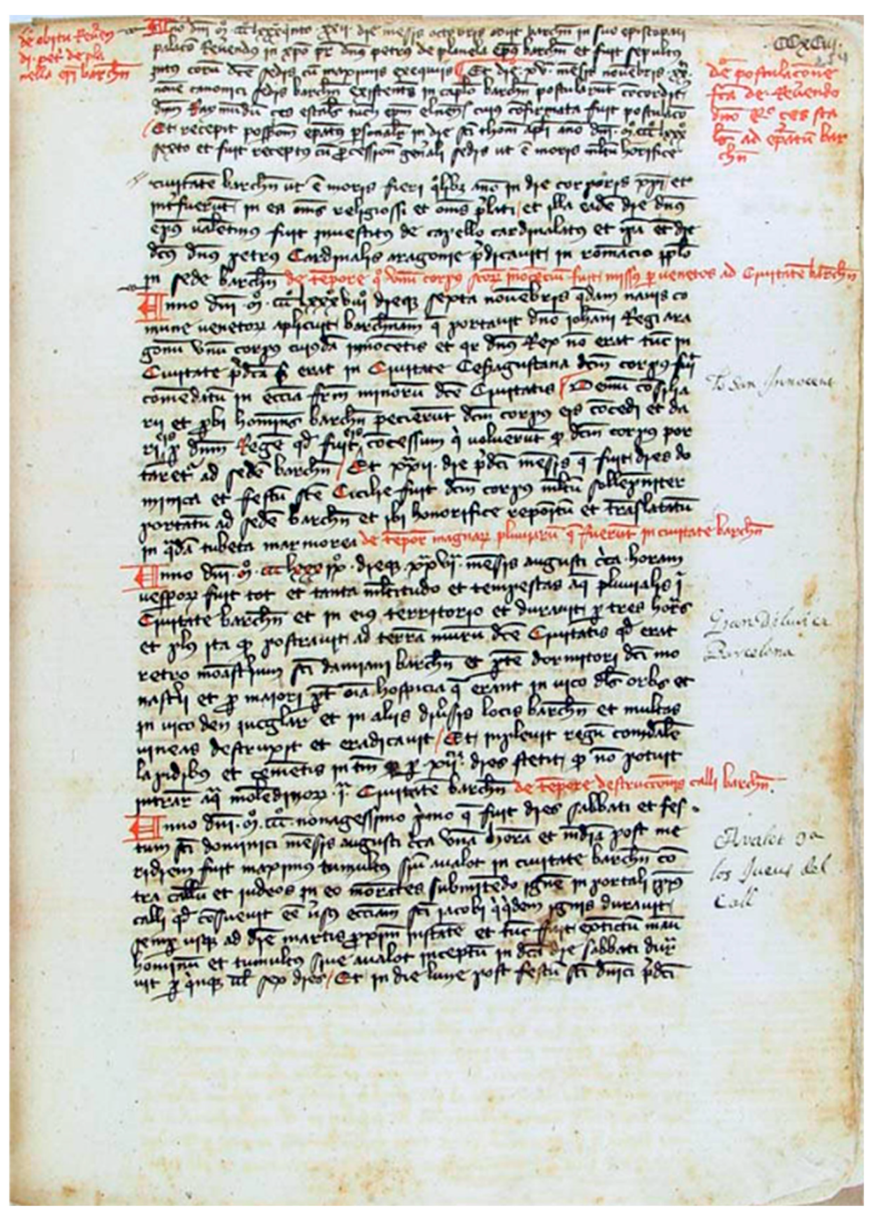
The Iberian Peninsula in general offers an excellent potential for documentary sources for this type of research, both in its cities and in its institutions, thanks to its long history. The types of documentary sources are different from those known in Central Europe or Northern Europe: In the western Mediterranean area, private or personal documentary sources are not common. However, there is a huge public, reliable and homogeneous documentary heritage: the administrative documentation of local authorities, both civil and ecclesiastical. This is documentation ranging from the 14th century to the present. The source materials are of great magnitude and continuity, they are well preserved and their access conditions are optimal (Figure 9).
The administrative sources are objective and reliable due to their origin and the official purposes that define them. Perhaps the main drawback is the low density of information that the sources contain in relation to natural hazards. Its content is routine: it contains bureaucratic procedures that have changed little in recent centuries in the kingdoms of the Hispanic Monarchy; however, phenomena that cause an alteration in these routines with some impact on the daily life of local communities are meticulously documented. Any event that requires a response from public institutions leaves detailed records in administrative sources. This administrative structure and its documentary sources and contents can be found beyond the Iberian Peninsula. Its scope can be defined as that of the group of former kingdoms of the Hispanic Monarchy in the 15th–19th centuries, which includes the states of Spain and Portugal, some regions of Italy and France, and the current Central and South American republics. In these territories, the cities with a minimum capacity for their authorities to generate, store and preserve documentary records, are likely to have useful documentary collections.
Information obtained on natural hazards has important applications for the challenges posed by climate change. It can inform urban planning and support the design and location of public infrastructures so as to reduce risk. Historical information can improve the management of water resources, both in excess (torrential rains, pluvial floods) and deficit situations (droughts). In addition to knowing in detail the behaviour of these natural events, the historical records can be used to supplement long time series based on event severity, duration, extension and frequency, at a range of timescales from daily to annual resolutions. In situations detailing water stress, the documentary records also preserve details of the economic and social impacts, with additional information documenting the decisions adopted at the private and institutional levels in response to these situations. Consequently, it is also possible to analyse the human dimension of natural hazards using the same sources, assessing the results of the different mitigation or adaptation measures applied.
Transcription:
“Anno domini m ccc lxxx ix dies xxvii mensis augusti circa horam vespro fuit tot et tanta multitudo et tempestas aquas pluvialis in civitate barchinona et in eio territorio et duravit per tres horas et plo ita qui postravit ad terram murum ditem Civitatis quod erat retro monasterius sancti damiani barchinone et pte dormitori dicti monasteri et per maiori pt ora hospitia q erant in vico dls Orbs et in vico den Jucglar et in alys diversis locus barchinona et multas vineas destruxit et eraditavit/Et inplevit regum comdale lapidibus et cementis in tum qp per xii dies stetit qp no potuit intrar aquam moledinos in civitate barchn.”
Reference: Biblioteca de Catalunya, Ms. 485, Bartolomé de Monfar, “Cronicó de Guillem Mascaró”, fol. 293. Source for graphic file: Biblioteca de Catalunya [97].
Download date: 7 May 2023
Rights: http://creativecommons.org/publicdomain/mark/1.0/ (accessed on 30 May 2023).
Some examples of this research include the analysis of flood episodes, with more than 5000 episodes catalogued in the Spanish Mediterranean Basin. Some episodes show unprecedented magnitudes compared to the instrumental period, such as that of November 1617, with descriptions of flood levels that exceed the absolute records of current instrumental series in different rivers, and with the documented destruction of 450 structures [98,99]. The administrative sources contain descriptive records of droughts on a daily and systematic basis; they do not contain instrumental records, but document the religious responses that the local authorities, civil and ecclesiastical structures launched in response to reports from the farmer’s guilds on the impact of the rainfall deficit on crops. Cultural proxydata such as the “pro pluvia” prayer ceremonies provide a degree of objectivity and independence from institutional structures, providing an opportunity for the quantification in event severity following the different formats of ceremonies that were performed, from simple prayers within the parish churches to processions through the streets of each town, or large pilgrimages to sanctuaries on a regional scale [100,101]. After a systematic compilation in different local archives, it is possible to map the behaviour of severe droughts on a daily basis, such as the droughts detected during the Little Ice Age in the Catalonia region [102] or the mega-drought identified during the Dalton Solar Minimum (1812–1824) in Spain [103].
The potential of historical sources of information is considerable when recognising their homogeneity and availability in hundreds of cities that have preserved documentary collections in local and departmental historical archives. Perhaps the only critical difficulty in this research is the sheer size of the enormous documentary heritage potentially available, with limited capacity for applying technological or computer resources to collect large amounts of information automatically. For example, collections from two main cities in Spain include 2000 linear kilometres of shelves with unexplored handwritten documents; of these, only 3–4% have been systematically consulted. Research opportunities are numerous and diverse, and unexplored materials can provide highly relevant insights into past natural hazards.

7. A Global Picture: The Help of the Web

In addition to the aforementioned national sources, there is an increasing range of web-based resources; these can be specific to a region (e.g., Vesuvio Observatory), country/national-level (e.g., British Hydrological Societies—Chronology of British Hydrological Events), continental (e.g., European Catalogue of Volcanoes) or global (e.g., Copernicus—ACRE) [104]. Although the number of such collections has grown in recent decades, they are often planned with a specific focus and/or objective and as such may be of limited utility if analysed from a different perspective. In recent years, there has been an increase in scanning and digitization programmes covering older materials, some undertaken by local/national archives to facilitate the increased availability of rare sources, whilst others have focused on widescale programs of scanning, such as “Google Books”, the tool developed by Google to search the text of digitized historical books. “Europeana” (https://www.europeana.eu/it (accessed on 30 May 2023)) [105], on the other hand, is the European digital library that brings together contributions already digitized by various institutions of the European Union; its resources include books, films, paintings, newspapers, sound archives, maps, manuscripts and archives.
Among the other web resources useful for the analysis of natural events is eBay is [106], while elsewhere social networks have facilitated sharing news, old documents, comments and photographs of great historical importance (see, for example, the Italian Facebook group called “Memoria storica dei processi geo-idrologici”, that is “Historical memory of geo-hydrological processes”). Sometimes, even small municipalities publish ‘misfortunes’ of the past that have severely affected the village on their webpage or as blogs. Developing a detailed knowledge of past event magnitude, frequency and impacts presents an opportunity to better understand future risks [56], and also explore our climate futures.
Numerous studies, institutions and procedures exist in the field of historical climatology, especially in Europe, which underline the value of historical documents in the analysis of climate change and climate extremes. In addition to temperature and precipitation trends over the last 1000 years, long-term reconstructions of climatic extremes are available, which often refer to modern risk assessment: LeRoy Ladurie 1983 [107] mainly for France, Alexandre 1987 [108] for Belgium and western and central Europe, van Engelen et al. 2001 [109] for the Netherlands, Jakubowski-Thiessen [110] for storm surges along the North Sea coastline, Büntgen et al. 2011 and 2021 [111,112] for the whole of Europe and Wanner 2016 for Central Europe [113]. In particular, questions on the frequency and intensity of floods, droughts, storm surges and storms, as well as their long-term changes and relations to climate change, are numerous [75,76,112,113,114,115]. In addition to reconstructions of long-term development, there are also elaborations on particularly striking phases such as the Spörer Minimum 1430–1445 [116]. Historical extreme events, such as the 1824 flood in the Neckar, have been used to improve current risk assessments [69,117].
Compilations, which also have a long tradition, form a genre of their own. They are often not written according to modern standards of source criticism, but they offer starting points for further research; for example, Weikinn [118] on weather history, Pfaff [119] on severe winters, or Pötzsch [120] on hydrological extremes along the transnational Elbe/Labe River.
There are numerous institutions and portals on selected topics, both at the national and European levels, which are based on sources such as the information platform “Undine” (https://undine.bafg.de/index.html (accessed on 30 May 2023)) [121]. “Undine” offers descriptions of current and historical high and low water levels for the Elbe, Oder, Rhine, Weser, Ems and Danube rivers, as well as current measured values and historical comparative values.
For technically relevant analyses, a number of impressive databases are now available online. These include PREDIFLOOD [122] in Spain, ORRION in France [123], ICOADS [124], CLIWOC [125], euroclimhist.ch [126] and REACHES [127]. In addition, there are specialised databases, such as those on droughts, including EDII [128], or on marine and early instrumental data [129,130]; further access can be found at https://www.ncdc.noaa.gov/dataaccess/paleoclimatologydata/datasets/historical (accessed on 30 May 2023) [131]. In the nationally funded digitisation projects KLIDADIGI [132] and the manifold historical records of the DWD [129], corresponding collections from German archive holdings have been integrated. In the context of these efforts, questions of data standardisation are also increasingly emerging. At PAGES (https://pastglobalchanges.org/ (accessed on 30 May 2023)) [133], for example, various palaeo data are merged in a common data format (LiPD) according to the FAIR (Findable Accessible Interoperable and Reusable) principles. This opens up new possibilities for Big Data analysis as well as reanalysis [134,135,136]. Likewise, citizen science activities are contributing to the indexing and analysis of historical datasets. Transcriptions from countless ship diaries, such as those in the https://oldweather.org/ (accessed on 30 May 2023) [137] project, are particularly advanced. These are connected to the International Comprehensive Ocean-Atmosphere Data Set (ICOADS) [138]. Here, the handwritten records of ship diaries, which are therefore difficult to analyse automatically, are transcribed by citizen scientists and thus made accessible for further analysis. Supported by the public media, the weather detectives (www.weatheraustria.net/ (accessed on 30 May 2023)) [139] were able to transcribe more than 400,000 entries from 11,000 citizen scientists by October 2015.
As a further step towards coping with and using the increased amounts of data, automation procedures and their analysis by means of statistics and artificial intelligence are increasingly being applied. In this context, the “digital humanities” are concerned with researching text-based questions in the humanities using digital methods. One methodological basis of these approaches is hermeneutic interpretation [140]. Texts that a few years ago were difficult to read can now be made accessible in a fraction of a second by means of automatic text recognition (Optical Character Recognition—OCR). Many approaches aim to go beyond qualitative analysis to quantification by means of word decomposition (tokenising). In order to go beyond word boundaries and to recognise grammatical connections, methods from the field of artificial intelligence and machine learning are increasingly being used. Common methods include text mining [141], natural language processing (NLP), reinforcement learning and classification. Their application to newspaper archives and information in the context of climatic issues is demonstrated by Yzaguirre, Smit and Warren [142] with their impressive analysis of over two million articles, and Kang and Park [143] using Korean newspapers.
Historical documents are also the basis for comprehensive catalogues; for example, of earthquakes in Central Europe from the years 800 to2008 compiled by Leydecker [144], as maintained by official bodies [145].
In conclusion, there is a wide range of historical sources from which anyone can learn about the past; finding them is not easy amidst the flood of existing data in the world. Once found, however, it is clear that each individual account requires an assessment of its veracity, such as by comparing it with other sources before putting it into the public domain. This should be taken as warm advice; for example, the landslide generated by the very strong earthquake that occurred in 1857 in Montemurro, Basilicata, Southern Italy [146]. Many Italian geologists and experts in later years reported that the landslide caused 5000 casualties (it would have been one of the most catastrophic historical landslides in Europe), but an analysis in the different archives (conducted also by the present authors) has never made it possible to ascertain a certain and verified figure. Perhaps it was a misunderstanding (probably generated by an error in Almagià’s 1907 book [147] that first reported this news): the earthquake caused the victims, while the landslide triggered by the earthquake probably did not cause loss of human life.

Author Contributions

Conceptualization and methodology, F.L., L.T., M.B., F.T.G., R.G., C.G., W.P., S.P. and H.S.; validation, investigation and data curation, F.L., L.T., M.B., F.T.G., R.G., C.G., W.P., S.P. and H.S.; proposal for the formation of the Special Issue, F.L.; search and contact for contributions from colleagues, F.L. and S.P.; writing—original draft preparation, F.L., L.T., M.B., F.T.G., R.G., C.G., W.P., S.P. and H.S.; writing—review and editing, F.L., L.T., M.B., F.T.G., R.G., C.G., W.P., S.P. and H.S.; grammatical correction of the text, H.S.; supervision, F.L. All authors have read and agreed to the published version of the manuscript.

Funding

This research was funded by: (i) FONTES PRIN Project (Italian National Research Project “Fonti geostoriche e sistemi informativi per la conoscenza del territorio e la gestione dei rischi ambientali e culturali”) (https://fontes.univr.it/ (accessed on 30 May 2023)), supported by Government Funding (Project CNR Number DTA.AD003.737). The research activity was also sustained by: (ii) the BEGIN project (DUS.AD017.190, CUP C39J20001760002), financed by Basilicata ERDF-ROP 2014-2020. This research was also funded by: (iii) “Project PID2021-126411OB-I00 (DENDROHIST), Ministerio de Ciencia e Innovación, Spain”.

Data Availability Statement

Data sharing does not apply to this paper.

Conflicts of Interest

The authors declare no conflict of interest.

References

  1. UNDRR. Available online: https://www.undrr.org/terminology/disaster (accessed on 28 June 2023).
  2. EM-DAT. The International Disaster Database. Available online: www.emdat.be (accessed on 28 June 2023).
  3. WMO. 2021. Available online: https://public.wmo.int/en/media/press-release/weather-related-disasters-increase-over-past-50-years-causing-more-damage-fewer (accessed on 28 June 2023).
  4. Barredo, J.I. Major Flood Disasters in Europe: 1950–2005. Nat. Hazards 2007, 42, 125–148. [Google Scholar] [CrossRef]
  5. Neumayer, E.; Barthel, F. Normalizing economic loss from natural disasters: A global analysis. Glob. Environ. Chang. 2011, 21, 13–24. [Google Scholar] [CrossRef]
  6. Roser, M.; Ritchie, H.; Ortiz-Ospina, E. World Population Growth. 2020. Available online: https://ourworldindata.org/world-population-growth (accessed on 15 June 2023).
  7. Settis, S. Paesaggio Costituzione Cemento. La Battaglia per L’ambiente Contro Il Degrado Civile; Einaudi Ed: Rome, Italy, 2010; p. 328. ISBN 9788806198718. [Google Scholar]
  8. Gizzi, F.T.; Porrini, D.; De Masi, F. Building a Natural Hazard Insurance System (NHIS): The Long-lasting Italian Case. Sustainability 2021, 13, 12269. [Google Scholar] [CrossRef]
  9. Butler, J.E. Natural Disasters; Heinemann Educational: Richmond, Australia, 1976; 138p. [Google Scholar]
  10. Alexander, D.E. Natural Disasters; University College London Press: London, UK; Kluwer Academic Publishers: Boston, MA, USA, 1993; 632p. [Google Scholar]
  11. Jonkman, S.N. Global Perspectives on Loss of Human Life Caused by Floods. Nat. Hazards 2005, 34, 151–175. [Google Scholar] [CrossRef]
  12. Shi, P.; Wang, J.; Xu, W.; Ye, T.; Yang, S.; Liu, L.; Fang, W.; Liu, K.; Li, N.; Wang, M. World Atlas of Natural Disaster Risk; Shi, P., Kasperson, R., Eds.; IHDP/Future Earth-Integrated Risk Governance Project Series; Springer: Berlin/Heidelberg, Germany, 2015. [Google Scholar] [CrossRef]
  13. Abbott, P.L. Natural Disasters, 10th ed.; McGrew-Hill: New York, NY, USA, 2018; 484p, ISBN 13-978-0078022982. [Google Scholar]
  14. Bobrowsky, P.T.; Marker, B. (Eds.) Encyclopedia of Engineering Geology; Springer: Berlin/Heidelberg, Germany, 2018; ISBN 978-3-319-73566-5. [Google Scholar]
  15. Baldo, M.; Bicocchi, C.; Chiocchini, U.; Giordan, D.; Lollino, G. LIDAR monitoring of mass wasting processes: The Radicofani landslide, Province of Siena, central Italy. Geomorphology 2009, 105, 193–201. [Google Scholar] [CrossRef]
  16. McCalpin, J.; Ferrario, F.; Figueiredo, P.; Livio, F.; Grützner, C.; Pisarska-Jamroży, M.; Quigley, M.; Reicherter, K.; Rockwell, T.; Štěpančíková, P.; et al. New developments in onshore paleoseismic methods, and their impact on Quaternary tectonic studies. Quat. Int. 2023, 664, 59–76. [Google Scholar] [CrossRef]
  17. Tonkin, T.N.; Midgley, N.G.; Cook, S.J.; Graham, D.J. Ice-cored moraine degradation mapped and quantified using an unmanned aerial vehicle: A case study from a polythermal glacier in Svalbard. Geomorphology 2016, 258, 1–10. [Google Scholar] [CrossRef]
  18. Elliott, J.R.; Walters, R.J.; Wright, T.J. The role of space-based observation in understanding and responding to active tectonics and earthquakes. Nat. Commun. 2016, 7, 13844. [Google Scholar] [CrossRef]
  19. Chen, W.; Sun, Z.; Han, J. Landslide susceptibility modeling using integrated ensemble weights of evidence with logistic regression and random forest models. Appl. Sci. 2019, 9, 171. [Google Scholar] [CrossRef]
  20. Hill, C.L. Geomorphological Survey. In The Encyclopedia of Archaeological Sciences; Wiley Blackwell: Hoboken, NJ, USA, 2018; pp. 1–4. [Google Scholar]
  21. Tavares, A.O.; Pato, R.L.; Magalhaes, M.C. Spatial and temporal land use change and occupation over the last half century in a peri-urban area. Appl. Geogr. 2012, 34, 432–444. [Google Scholar] [CrossRef]
  22. Skidmore, A. Environmental Modelling with GIS and Remote Sensing; Skidmore, A., Ed.; CRC Press: Boca Raton, FL, USA; Taylor and Francis: New York, NY, USA, 2017; 266p. [Google Scholar]
  23. Zhang, K.; Xue, X.; Hong, Y.; Gourley, J.J.; Lu, N.; Wan, Z.; Hong, Z.; Wooten, R. iCRESTRIGRS: A coupledmodeling system for cascading flood-landslide disaster forecasting. Hydrol. Earth Syst. Sci. 2016, 20, 5035–5048. [Google Scholar] [CrossRef]
  24. Brunetti, M.T.; Melillo, M.; Peruccacci, S.; Ciabatta, L.; Brocca, L. How far are we from the use of satellite rainfall products in landslide forecasting? Remote Sens. Environ. 2018, 210, 65–75. [Google Scholar] [CrossRef]
  25. Govi, M.; Turitto, O. Ricerche Bibliografiche per un Catalogo Sulle Inondazioni, Piene Torrentizie e Frane in Valtellina e Valchiavenna; Supplemento a GEAM, Quaderni di Studi e di Documentazione; Associazione Mineraria Subalpina: Torino, Italy, 1994; 249p. (In Italian) [Google Scholar]
  26. Yevjevich, V. Floods and society. In Coping with Floods; Rossi, G., Harmancioğlu, N., Yevjevich, V., Eds.; NATO ASI Series; Springer: Dordrecht, The Netherlands, 1994; Volume 257. [Google Scholar] [CrossRef]
  27. Luino, F.; Belloni, A.; Padovan, N.; Bassi, M.; Bossuto, P.; Fassi, P. Historical and geomorphological analysis as a research tool for the identification of flood-prone zones and its role in the revision of town planning: The Oglio basin (Valcamonica—Northern Italy). In Proceedings of the 9th Congress of the IAEG, Durban, South Africa, 16–20 September 2002; pp. 191–200. [Google Scholar]
  28. Esposito, E.; Porfido, S.; Violante, C. (Eds.) Il Nubifragio Dell’ottobre 1954 a Vietri sul Mare-Costa di Amalfi, Salerno; GNDCI-CNR: Rome, Italy, 2004. (In Italian) [Google Scholar]
  29. Tropeano, D.; Turconi, L. Using Historical Documents for Landslide, Debris Flow and Stream Flood Prevention. Applications in Northern Italy. Nat. Hazards 2004, 31, 663–679. [Google Scholar] [CrossRef]
  30. Tropeano, D.; Luino, F.; Turconi, L.; Agangi, A.; Audisio, C.; Biddoccu, M.; Chiarle, M.; Casazza, M.; Cirio, C.G.; Fassi, P.; et al. Eventi di Piena e Frana in Italia Settentrionale Nel Periodo 2002–2004; SMS: Torino, Italy, 2006; 158p. (In Italian) [Google Scholar]
  31. Devoli, G.; Morales, A.; Høeg, K. Historical landslides in Nicaragua-collection and analysis of data. Landslides 2007, 4, 5–18. [Google Scholar] [CrossRef]
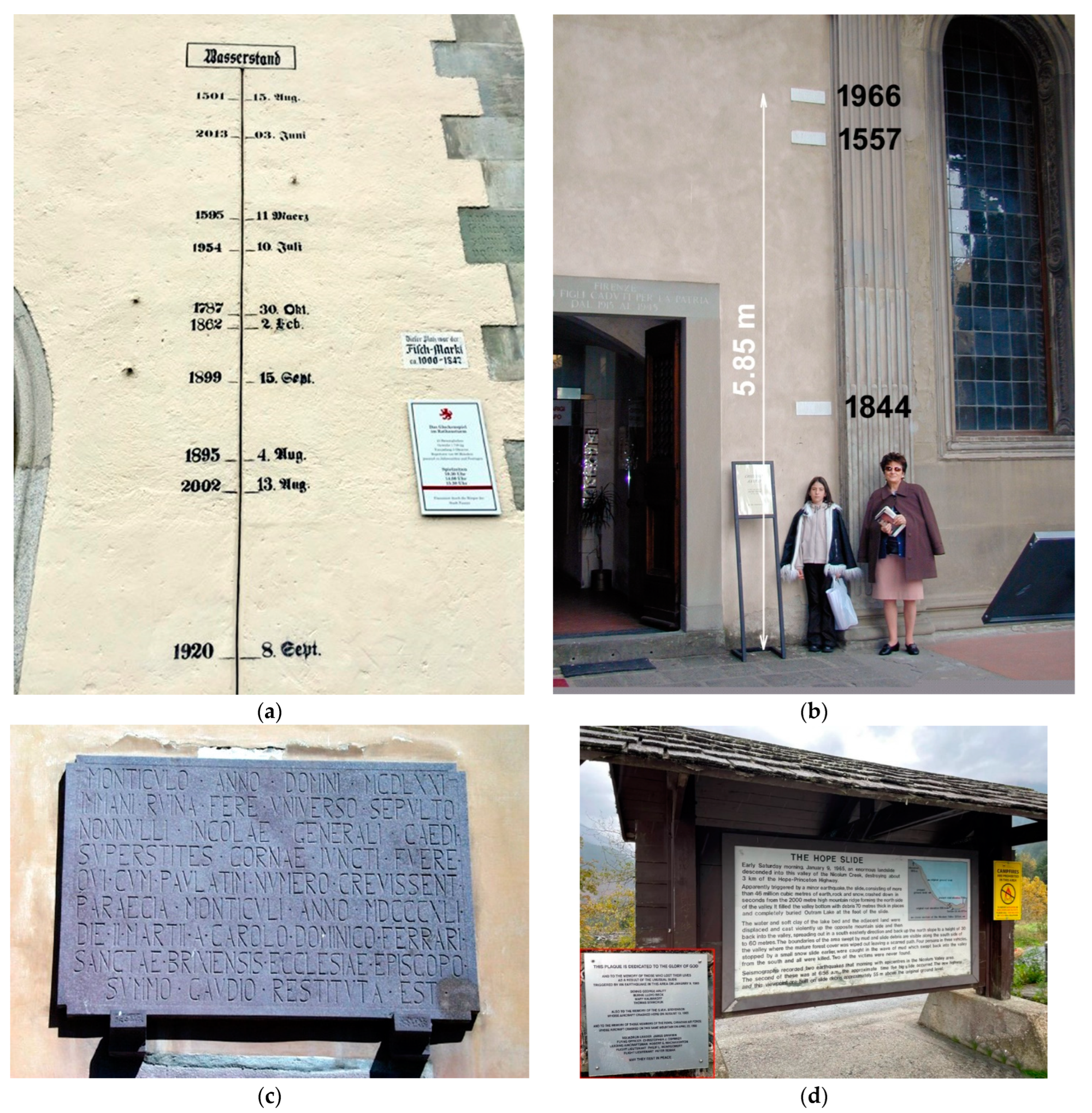
  32. Macdonald, N. On epigraphic records: Valuable resource in reassessing flood risk and long-term climate variability. Environ. Hist. 2007, 12, 136–140. [Google Scholar] [CrossRef]
  33. Porfido, S.; Esposito, E.; Alaia, F.; Molisso, F.; Sacchi, M. The use of documentary sources for reconstructing flood chronologies on the Amalfi rocky coast (southern Italy). In Geohazard in Rocky Coastal Areas; Violante, C., Ed.; Geological Society: London, UK, 2009; pp. 173–187. ISBN 978-1-86239-282-3. [Google Scholar] [CrossRef]
  34. Foscari, G.; Esposito, E.; Mazzola, S.; Porfido, S.; Sciarrotta, S.; Santoro, G. Lo Alluvione. Il Disastro del 1773 a Cava Tra Memoria Storica e Rimozione; Edisud: Salerno, Italy, 2013; pp. 9–31. ISBN 978-88-95154-87-9. (In Italian) [Google Scholar]
  35. Hutař, J.; Melichar, M. The long decade of digital preservation in heritage institutions in the Czech Republic: 2002–2014. Int. J. Digit. Curation 2015, 10, 173–183. [Google Scholar] [CrossRef]
  36. McEwen, L.; Garde-Hansen, J.; Holmes, A.; Jones, O.; Krause, F. Sustainable flood memories, lay knowledges and the development of community resilience to future flood risk. Trans. Inst. Br. Geogr. 2017, 42, 14–28. [Google Scholar] [CrossRef]
  37. Luino, F.; Turconi, L. Eventi di Piena e Frana in Italia Settentrionale Nel Periodo 2005–2016; SMS: Torino, Italy, 2017; 478p. (In Italian) [Google Scholar]
  38. Sangster, H.; Jones, C.; Macdonald, N. The co-evolution of historical source materials in the geophysical, hydrological and meteorological sciences: Learning from the past and moving forward. Prog. Phys. Geogr. 2018, 42, 61–82. [Google Scholar] [CrossRef]
  39. Garnier, E.; Lahournat, F. Japanese stone monuments and disaster memory–Perspectives for DRR. Disaster Prev. Manag. 2022, 31, 1–12. [Google Scholar] [CrossRef]
  40. Naylor, S.; Macdonald, N.; Bowen, J.P.; Endfield, G. Extreme weather, school logbooks and social vulnerability: The Outer Hebrides, Scotland, in the late nineteenth and early twentieth centuries. J. Hist. Geogr. 2022, 78, 84–94. [Google Scholar] [CrossRef]
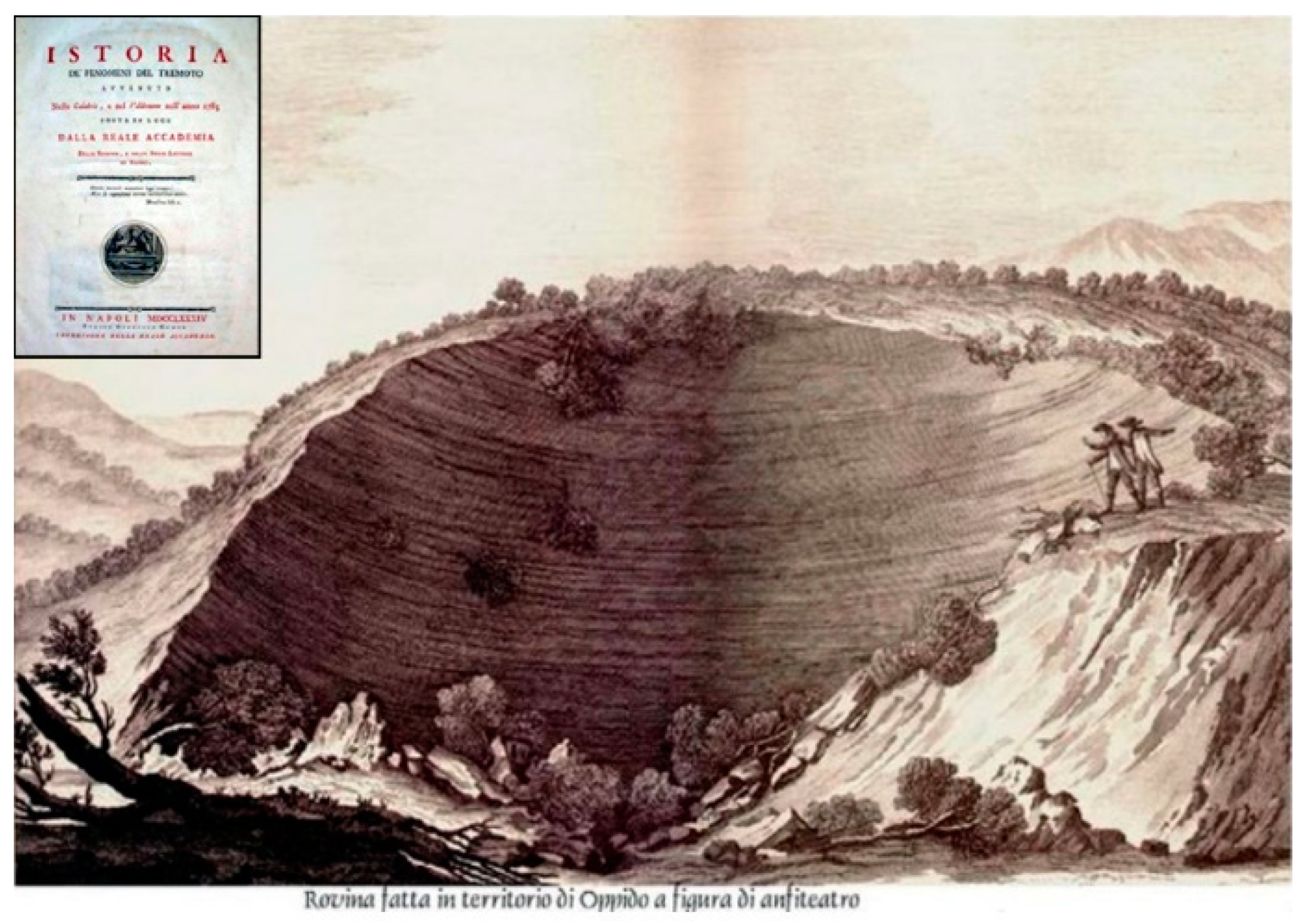
  41. Sarconi, M. Istoria de’ Fenomeni Del Tremoto Avvenuto Nelle Calabrie, e Nel Valdemone Nell’anno 1783 Posta in Luce Dalla Reale Accademia Delle Scienze, e Delle Belle Lettere di Napoli; Campo: Napoli, Italy, 1784. (In Italian) [Google Scholar]
  42. Konvitz, J. Cartography in France 1660–1848; Le Roy, L., Ed.; University of Chicago Press: Chicago, IL, USA, 1987. [Google Scholar]
  43. Forty, S.; Swift, M. Historical Maps of the Napoleonic Wars; Brassey’s: London, UK, 2003; 144p. [Google Scholar]
  44. Radding, L.; Western, J. What’s in a name? Linguistics, geography, and toponyms. Geogr. Rev. 2010, 100, 394–412. [Google Scholar] [CrossRef]
  45. Dell’O, E. Historicizing vulnerability: Place-names, risk and memory in the Mont Blanc area. AIMS Geosci. 2019, 5, 493–508. [Google Scholar] [CrossRef]
  46. Newhall, B. The History of Photographyfrom 1839 to the Present; The Museum of Modern Art: New York, NY, USA, 1988; 320p, ISBN 100870703811/139780870703812. [Google Scholar]
  47. House, E. A History of Photography; Taschen: Koln, Germany, 2012; 768p, ISBN 103836540991. [Google Scholar]
  48. Cosgrove, D.; Fox, W.L. Photography and Flight; Reaktion Books: London, UK, 2010; 146p. [Google Scholar]
  49. Padley, G. The Story of Aerial Photography (150 Years of Breathtaking Imagery); Laurence King Publishing: London, UK, 2019; 256p. [Google Scholar]
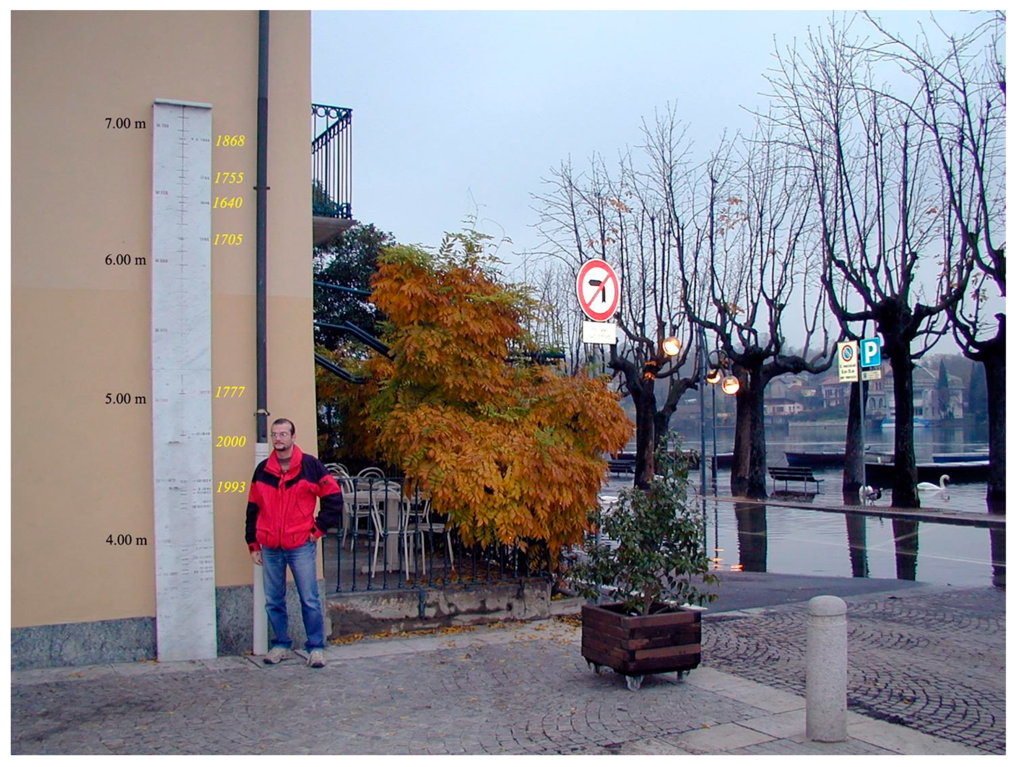
  50. Luino, F.; Belloni, A.; Turconi, L.; Faccini, F.; Mantovani, A.; Fassi, P.; Marincioni, F.; Caldiroli, G. An historical geomorphological approach to flood hazard management along the shores of an alpine lake (Northern Italy). Nat. Hazards 2018, 94, 471–488. [Google Scholar] [CrossRef]
  51. Iwaka, K.; Kozuki, Y.; Yamanaka, R.; Tanabe, S.; Murakami, H. Values and Applications of Earthquake and Tsunami Stone Monuments in Tokushima. J. Jpn. Soc. Civ. Eng. Ser. B2 (Coast. Eng.) 2011, 67, I_1261–I_1265. [Google Scholar] [CrossRef]
  52. Luino, F.; Ramasco, M.; Susella, G. Atlante dei Centri Abitati Instabili Piemontesi; Monograph: Torino, Italy, 1993; 245p. (In Italian) [Google Scholar]
  53. Gizzi, F.T.; Masini, N. Historical Earthquakes and Damage Patterns for Potenza (Basilicata, Southern Italy). Ann. Geophys. 2007, 50, 599–611. [Google Scholar]
  54. Gizzi, F.T.; Potenza, M.R.; Zotta, C. 23 November 1980 Irpinia–Basilicata earthquake (Southern Italy): Towards a full knowledge of the seismic effects. Bull. Earthq. Eng. 2012, 10, 1109–1131. [Google Scholar] [CrossRef]
  55. Schenk, G.J. Managing natural hazards: Environment, society, and politics in Tuscany and the Upper Rhine Valley in the Renaissance (1270–1570). In Historical Disasters in Context: Science, Religion, and Politics; Janku, A., Schenk, G.J., Mauelshagen, F., Eds.; Routledge: New York, NY, USA; London, UK, 2012; pp. 31–53. [Google Scholar]
  56. Blöschl, G.; Kiss, A.; Viglione, A.; Barriendos, M.; Böhm, O.; Brazdil, R.; Coeur, D.; Demaree, G.; Llasat, M.C.; MacDonald, N.; et al. Current European flood-rich period exceptional compared with past 500 years. Nature 2020, 583, 560–566. [Google Scholar] [CrossRef] [PubMed]
  57. Gizzi, F.T.; Potenza, M.R. The Scientific Landscape of November 23rd, 1980 Irpinia-Basilicata Earthquake: Taking Stock of (Almost) 40 Years of Studies. Geosciences 2020, 10, 482. [Google Scholar] [CrossRef]
  58. Glaser, R.; Kahle, M. Reconstructions of droughts in Germany since 1500–Combining hermeneutic information and instrumental records in historical and modern perspectives. Clim. Past 2020, 16, 1207–1222. [Google Scholar] [CrossRef]
  59. Elleder, L.; Kašpárek, L.; Šírová, J.; Kabelka, T. Low water stage marks on hunger stones: Verification for the Elbe from 1616 to 2015. Clim. Past 2020, 16, 1821–1846. [Google Scholar] [CrossRef]
  60. Vitali, S. Gli Archivi di Stato Italiani Fra Memoria Nazionale e Identità Locali; Società Editrice Il Mulino: Bologna, Italy, 2011; pp. 119–129, (In Italian). [Google Scholar] [CrossRef]
  61. Archivio Centrale Dello Stato. Available online: https://acs.cultura.gov.it/ (accessed on 4 April 2023).
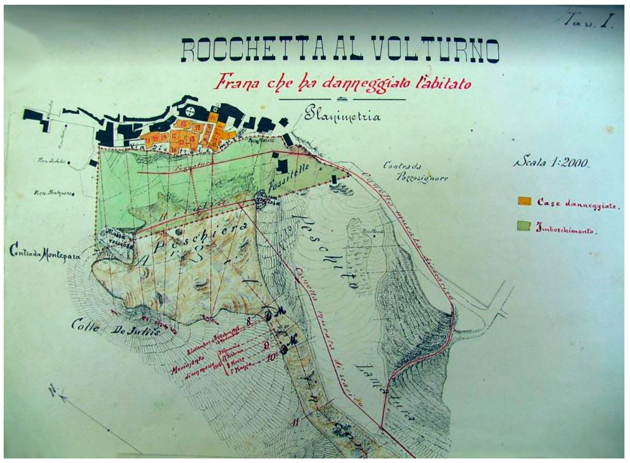
  62. Archivio di Stato di Campobasso. La frana di Rocchetta al Volturno; Archivio di Stato di Campobasso: Genio Civile, Italy, 1906. (In Italian) [Google Scholar]
  63. Palmieri, W. Uomini e dissesti: Frane e alluvioni nell’Ottocento molisano. In Storia del Molise in età Contemporanea; Massullo, G., Ed.; Donzelli Editore: Rome, Italy, 2006; pp. 205–241. (In Italian) [Google Scholar]
  64. Brunetti, D. L’archivio comunale dall’Unità al 1897. In Ministero Dei Beni e Delle Attività Culturali e Del Turismo Direzione Generale Archivi; Modus Sistemas: Rome, Italy, 2016; 372p. (In Italian) [Google Scholar]
  65. Medolago, G. La rovina del Goglio a Gromo e Valgoglio nel 1666. In Disastri e Comunità Alpine; ISTA, Printed by the Factory on Behalf of Borè srl: Rome, Italy, 2019; pp. 59–76. (In Italian) [Google Scholar]
  66. Monumenta Germaniae Historica MGH. Available online: www.dmgh.de (accessed on 4 April 2023).
  67. Freiburger Zeitung. Available online: https://www.ub.uni-freiburg.de/recherche/digitale-bibliothek/freiburger-historische-bestaende/freiburger-zeitung (accessed on 4 April 2023).
  68. Tambora. Available online: https://tambora.org (accessed on 4 April 2023).
  69. Riemann, D.; Glaser, R.; Kahle, M.; Vogt, S. The CRE tambora.org–New data and tools for collaborative research in climate and environmental history. Geosci. Data J. 2016, 2, 63–77. [Google Scholar] [CrossRef]
  70. Damm, B.; Klose, M. The landslide database for Germany: Closing the gap at national level. Geomorphology 2015, 249, 82–93. [Google Scholar] [CrossRef]
  71. Kreibich, K.; Schröter, K.; Bubeck, P.; Kunz, M.; Mahlke, H.; Parolai, S.; Khazai, B.; Daniell, J.; Lakes, T. A review of multiple natural hazards and risks in Germany. Nat. Hazards 2014, 74, 2279–2304. [Google Scholar] [CrossRef]
  72. Kempe, M. Mind the next flood! Memories of natural disasters in Northern Germany from the sixteenth century to the present. Mediev. Hist. J. 2006, 10, 327–354. [Google Scholar] [CrossRef]
  73. Behre, K.E. Die Veränderungen der niedersächsischen Küstenlinien in den letzten 3000 Jahren und ihre Ursachen. Probl. Der Küstenforschung Im Südlichen Nord. 1999, 26, 9–33. (In German) [Google Scholar]
  74. Behre, K.E. Coastal development, sea-level change and settlement history during the later Holocene in the Clay District of Lower Saxony (Niedersachsen), northern Germany. Quat. Int. 2004, 112, 37–53. [Google Scholar] [CrossRef]
  75. Glaser, R.; Stangl, H. Historical floods in the Dutch Rhine delta. Nat. Hazards Earth Syst. Sci. 2003, 3, 605–613. [Google Scholar] [CrossRef]
  76. Himmelsbach, I.; Glaser, R.; Schönbein, J.; Riemann, D.; Martin, B. Reconstruction of flood events based on documentary data and transnational flood risk analysis of the upper Rhine and its French and German tributaries since AD 1480. Hydrol. Earth Syst. Sci. 2015, 19, 4149–4164. [Google Scholar] [CrossRef]
  77. Brázdil, R.; Kundzewicz, Z.W.; Benito, G. Historical hydrology for studying flood risk in Europe. Hydrol. Sci. J. 2006, 51, 739–764. [Google Scholar] [CrossRef]
  78. Bürger, K.; Dostal, P.; Seidel, J.; Imbery, F.; Barriendos, M.; Mayer, H.; Glaser, R. Hydrometeorological reconstruction of the 1824 flood event in the Neckar River basin (southwest Germany). Hydrol. Sci. J. 2006, 51, 864–877. [Google Scholar] [CrossRef]
  79. Herget, J.; Meurs, H. Reconstructing peak discharges for historic flood levels in the city of Cologne, Germany. Glob. Planet. Chang. 2010, 70, 108–116. [Google Scholar] [CrossRef]
  80. Roggenkamp, T.; Herget, J. Reconstructing peak discharges of historic floods of the River Ahr, Germany. Erdkunde 2014, 68, 49–59. [Google Scholar] [CrossRef]
  81. Grünthal, G. The history of historical earthquake research in Germany. Ann. Geophys. 2004, 42, 631–643. [Google Scholar] [CrossRef]
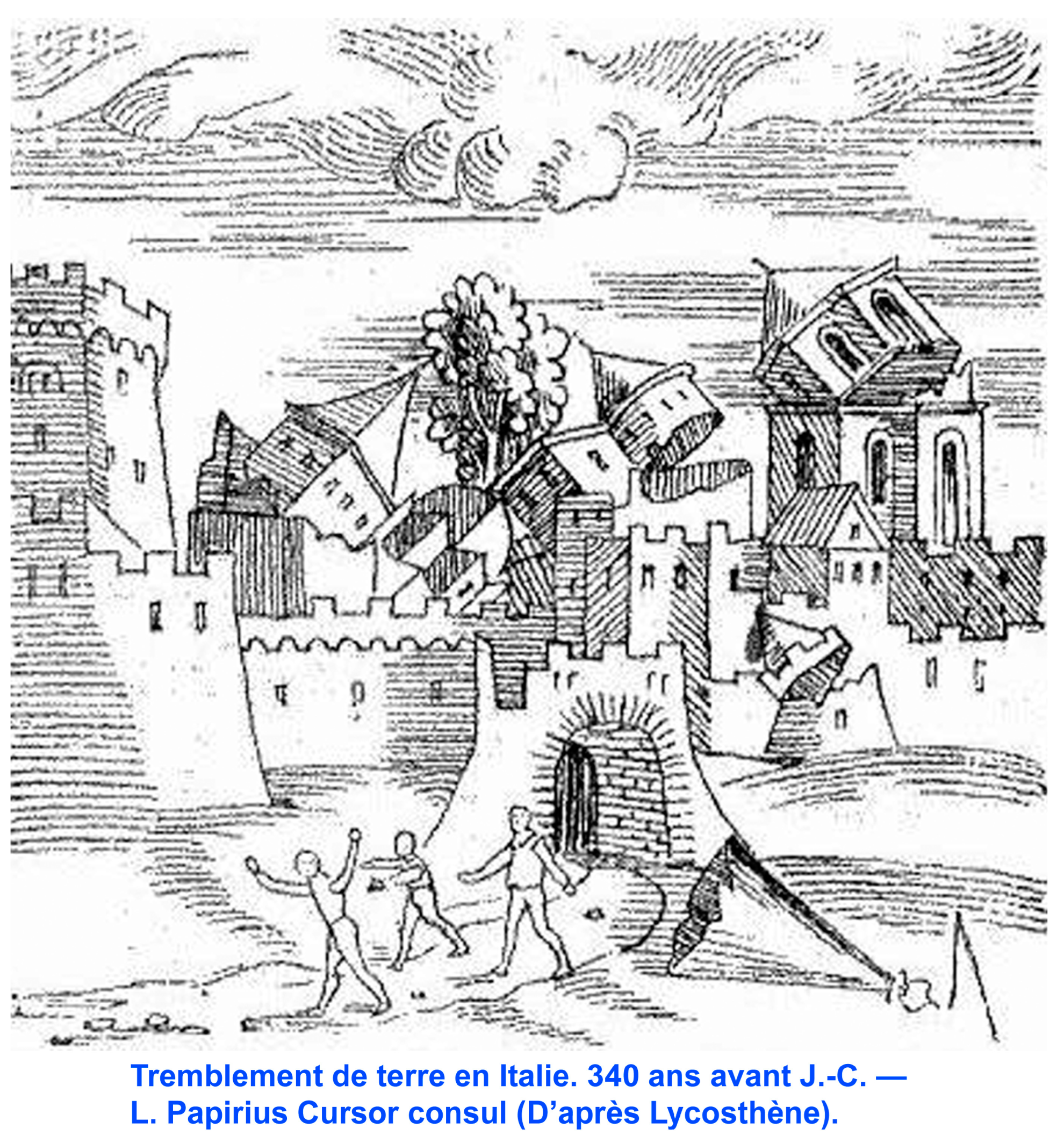
  82. Lycosthenes, C.; Wolfharth, K.; Wolffard, K. Prodigiorium ac Ostentorum Chronicon, Quae Prater Naturae Ordinem; per Henricum Petri: Basel, Switzerland, 1557; 670p. [Google Scholar]
  83. von Hoff, K.E.A. Chronik der Erdbeben und Vulcan-Ausbrüche; I. Teil; Justus Perthes: Gotha, Germany, 1840; 470p. [Google Scholar]
  84. von Hoff, K.E.A. Chronik der Erdbeben und Vulcan-Ausbrüche; II. Teil; Justus Perthes: Gotha, Germany, 1841; 406p. [Google Scholar]
  85. Sieberg, A. Beiträge Zum Erdbebenkatalog Deutschlands und Angrenzender Gebietefür die Jahre 58 Bis 1799; Mitt. Deutsch. Reichs-Erdbebendienst: Jena, Germany, 1940; 112p. (In German) [Google Scholar]
  86. Sponheuer, W. Erdbebenkatalog Deutschlands und der Angrenzenden Gebiete für die Jahre 1800–1899; Mitt. Deutsch. Erdbebendienst: Berlin, Germany, 1952; 195p. (In German) [Google Scholar]
  87. Lersch, B.M. Erdbebenchronik für die Zeit Von 2362 v. Chr. Bis 1897; Springer: Aachen, Germany, 1897. (In German) [Google Scholar]
  88. Macdonald, N.; Sangster, H. High magnitude flooding across Britain since A.D. 1750. Hydrol. Earth Syst. Sci. 2017, 21, 1631–1650. [Google Scholar] [CrossRef]
  89. Haigh, I.; Ozsoy, O.; Wadey, M.P.; Nicholls, R.J.; Gallop, S.L.; Wahl, T.; Brown, J.M. An improved database of coastal flooding in the United Kingdom from 1915 to 2016. Sci. Data 2017, 4, 170100. [Google Scholar] [CrossRef] [PubMed]
  90. Bowen, J.P.; Macdonald, N. A dreadful phenomenon described and improved: Reverend John Fletcher’s account of the Buildwas earthquake of 1773. J. Hist. Geogr. 2019, 64, 72–84. [Google Scholar] [CrossRef]
  91. Murphy, C.; Wilby, R.L.; Matthews, T.; Horvath, C.; Crampsie, A.; Ludlow, F.; Noone, S.; Brannigan, J.; Hannaford, J.; McLeman, R.; et al. The forgotten drought of 1765–1768: Reconstructing and re-evaluating historical droughts in the British and Irish Isles. Int. J. Climatol. 2020, 40, 5329–5351. [Google Scholar] [CrossRef]
  92. Hawkins, E.; Burt, S.; McCarthy, M.; Murphy, C.; Ross, C.; Baldock, M.; Brazier, J.; Hersee, G.; Huntley, J.; Meats, R.; et al. Millions of historical monthly rainfall observations taken in the UK and Ireland rescued by citizen scientists. Geosci. Data J. 2023, 10, 246–261. [Google Scholar] [CrossRef]
  93. Musson, R.M.W. A critical history of British earthquakes. Ann. Geophys. 2004, 47, 597–609. [Google Scholar]
  94. Macdonald, N.; Naylor, S.; Bowen, J.P.; Harvey-Fishenden, A.; Graham, E. Understanding weather futures based on the past: A case of Stornoway, Outer Hebrides. Scott. Geogr. J. 2023, 78, 84–94. [Google Scholar] [CrossRef]
  95. Kjeldsen, T.R.; Macdonald, N.; Lang, M.; Mediero, L.; Albuquerque, T.; Bogdanowicz, E.; Brázdil, R.; Castellarin, A.; David, V.; Fleig, A.; et al. Documentary evidence of past floods in Europe and their utility in flood frequency estimation. J. Hydrol. 2014, 517, 963–973. [Google Scholar] [CrossRef]
  96. Endfield, G.H.; Veale, L.; Royer, M.-J.; Bowen, J.P.; Davies, S.; Macdonald, N.; Naylor, S.; Jones, C.; Tyler-Jones, R. Extreme weather in the UK: Past, present and future—event details from the TEMPEST database. Cent. Environ. Data Anal. 2017. [Google Scholar] [CrossRef]
  97. Biblioteca de Catalunya (Library of Catalonia), Section Manuscripts, Ms. 485, Bartolomé de Monfar, "Cronicó de Guillem Mascaró". 1531. 1 Volume. Available online: https://mdc.csuc.cat/digital/collection/manuscritBC/id/28989/rec/1 (accessed on 4 April 2023).
  98. Thorndycraft, V.; Barriendos, M.; Benito, G.; Rico, M.; Casas, A. The catastrophic floods of A.D. 1617 in Catalonia (NE Spain) and their climatic context. Hydrol. Sci. J. 2006, 51, 899–912. [Google Scholar] [CrossRef]
  99. Pino, P.; Alberola, A.; Balasch, C.; Barriendos, M.; Gil, S.; Grau-Satorras, M.; Mazón, J.; Pérez Morales, A.; Tuset, J. Major flood events reconstruction from a multi-proxy approach. The case study of November 1617 flood event in the Mediterranean Basins of Iberian Peninsula. In Proceedings of the 18th EGU General Assembly, European Geosciences Union, Wien, Austria, 8–13 April 2018. [Google Scholar]
  100. Martin-Vide, J.; Barriendos, M. The use of rogation ceremony records in climatic reconstruction: A case study from Catalonia (Spain). Clim. Chang. 1995, 30, 201–221. [Google Scholar] [CrossRef]
  101. Barriendos, M. Climatic variations in the Iberian Peninsula during the late Maunder Minimum (AD 1675-1715): An analysis of data from rogation ceremonies. Holocene 1997, 7, 105–111. [Google Scholar] [CrossRef]
  102. Oliva, M.; Ruiz-Fernández, J.; Barriendos, M.; Benito, G.; Cuadrat, J.M.; García-Ruiz, J.M.; Giralt, S.; Gómez-Ortiz, A.; Hernández, A.; López-Costas, O.; et al. The Little Ice Age in Iberian mountains”. Earth Sci. Rev. 2018, 177, 175–208. [Google Scholar] [CrossRef]
  103. Barriendos, M.; Barriendos, J.; Hernández, M.; Gil-Guirado, S.; Olcina-Cantos, J. Drought variability in the Spanish Mediterranean Basin during the Dalton Solar Minimum period (1790–1830). In Proceedings of the EGU General Assembly 2023, Vienna, Austria, 24–28 April 2023. EGU23-3976. [Google Scholar] [CrossRef]
  104. Allan, R.; Endfield, G.; Damodaran, V.; Adamson, G.; Hannaford, M.; Carroll, F.; Macdonald, N.; Groom, N.; Jones, J.; Williamson, F.; et al. Toward integrated historical climate research: The example of Atmospheric Circulation Reconstructions over the Earth. Wires Clim. Chang. 2016, 7, 164–174. [Google Scholar] [CrossRef]
  105. Europeana. Available online: https://www.europeana.eu/it (accessed on 4 April 2023).
  106. Gizzi, F.T. The electronic trading site eBay as a useful tool for obtaining historical data on natural events. Comput. Geosci. 2009, 35, 1950–1957. [Google Scholar] [CrossRef]
  107. Le Roy Ladurie, E. Histoire du Climat Depuis L’an Mil; FLAMMARION: Paris, France, 1983. [Google Scholar]
  108. Alexandre, P. Le Climat in Europe au Moyen Age; l’École des Hautes études en Sciences Sociales: Paris, France, 1987; 827p. [Google Scholar]
  109. van Engelen, A.F.V.; Buisman, J.; Ijnsen, F. A Millennium of Weather, Winds and Water in the Low Countries. In History and Climate; Jones, P.D., Ogilvie, A.E.J., Davies, T.D., Briffa, K.R., Eds.; Springer: Boston, MA, USA, 2001. [Google Scholar] [CrossRef]
  110. Jakubowski-Thiessen, M. Die großen Mandränken. Sturmfluten in Nordfriesland. In (Hrsg.): Das Große Nordfriesland-Buch; Steensen, T., Ed.; Verlag Ellert & Richter: Hamburg, Germany, 2000; pp. 122–133. (In German) [Google Scholar]
  111. Büntgen, U.; Tegel, K.; Nicolussi, M.; McCormick, D.; Frank, V.; Trouet, J.O.; Kaplan, F.; Herzig, K.-U.; Heussner, H.; Wanner, J.; et al. 2500 Years of European Climate Variability and Human Susceptibility. Science 2011, 331, 578–582. [Google Scholar] [CrossRef]
  112. Büntgen, U.; Urban, O.; Krusic, P.J.; Rybníček, M.; Kolář, T.; Kyncl, T.; Ač, A.; Koňasová, E.; Čáslavsky, J.; Esper, J.; et al. Recent European drought extremes beyond Common Era background variability. Nat. Geosci. 2021, 14, 190–196. [Google Scholar] [CrossRef]
  113. Wanner, H. Klima und Mensch—Eine 12′000-jährige Geschichte Hardcover; Haupt Verlag: Bern, Switzerland, 2016; 276S. [Google Scholar]
  114. Glaser, R.; Stangl, H.; Lang, M. Floods in Central Europe Since AD 1300 And Their Regional Context. In Colloque SHF “Etiages et Crues Extrémes Régionaux en Europe”; Taylor & Francis: Lyon, France, 2004; pp. 63–72. [Google Scholar]
  115. Cook, E.R.; Seager, R.; Kushnir, Y.; Briffa, K.R.; Büntgen, U.; Frank, D.; Krusic, P.J.; Tegel, W.; van der Schrier, G.; Andreu-Hayles, L.; et al. Old World megadroughts and pluvials during the Common Era. Sci. Adv. 2015, 1, e1500561. [Google Scholar] [CrossRef] [PubMed]
  116. Camenisch, C.; Keller, K.M.; Salvisberg, M.; Amann, B.; Bauch, M.; Blumer, S.; Brázdil, R.; Brönnimann, S.; Büntgen, U.; Campbell, B.M.S.; et al. The Early Spörer Minimum—A Period of Extraordinary Climate and Socio-Economic Changes in Western and Central Europe. Clim. Past 2016, 1–33. Available online: http://www.clim-past-discuss.net/cp-2016-7/ (accessed on 4 April 2023).
  117. Sudhaus, D.; Seidel, J.; Bürger, K.; Dostal, P.; Imbery, F.; Mayer, H.; Glaser, R.; Konold, W. Discharges of past flood events based on historical river profiles. Hydrol. Earth Syst. Sci. 2008, 12, 1201–1209. [Google Scholar] [CrossRef]
  118. Weikinn, C. Quellentexte Zur Witterungsgeschichte Europas von der Zeitwende bis Zum Jahre 1850; Akademie Verlag: Berlin, Germany, 1958. [Google Scholar]
  119. Pfaff, C.H. Über die Strengen Winter Vorzüglich des Achtzehnten Jahrhunderts und über den Letzt Verflossenen Winter von 1808–1809; Academischen Buchhandlung: Freiberg, Germany, 1809. [Google Scholar]
  120. Pötzsch, C.G. Chronologische Geschichte der Großen Wasserfluthen des Elbstroms Seit Tausend und Mehr Jahren; Waltherische Hofbuchhandlung: Dresden, Germany, 1784. [Google Scholar]
  121. Undine Informationsplattform. Available online: https://undine.bafg.de/index.html (accessed on 30 May 2023).
  122. Barriendos, M.; Ruiz-Bellet, J.L.; Tuset, J.; Mazón, J.; Balasch, J.C.; Pino, D.; Ayala, J.L. The “Prediflood” database of historical floods in Catalonia (NE Iberian Peninsula) AD 1035–2013, and its potential applications in flood analysis. Hydrol. Earth Syst. Sci. 2014, 18, 4807–4823. [Google Scholar] [CrossRef]
  123. Martin, B.; Giacona, F.; Furst, B.; Edelblutte, C.; Holleville, N.; Vitoux, M.C.; Glaser, R.; Himmelsbach, I.; Schönbein, J.; Heitz, C.; et al. ORRION: A Specific Information Sharing Tool to (re)Build a “Flood Risk Culture” in the Rhine Graben (France–Germany). E3SWeb Conf. 2016, 7, 18. Available online: https://www.e3sconferences.org/articles/e3sconf/abs/2016/02/e3sconf_flood2016_15005/e3sconf_flood2016_15005.html (accessed on 30 May 2023). [CrossRef]
  124. Woodruff, S.D.; Worley, S.J.; Lubker, S.J.; Ji, Z.; Freeman, J.E.; Berry, D.I.; Brohan, P.; Kent, E.C.; Reynolds, R.W.; Smith, S.R.; et al. ICOADS Release 2.5: Extensions and enhancements to the surface marine meteorological archive. Int. J. Climatol. 2011, 31, 951–967. [Google Scholar] [CrossRef]
  125. García-Herrera, R.; Können, G.P.; Wheeler, D.A.; Prieto, M.R.; Jones, P.D.; Koek, F.B. CLIWOC: A Climatological Database for the World’s Oceans 1750–1854. Clim. Chang. 2005, 73, 1–12. [Google Scholar] [CrossRef]
  126. Pfister, C. Euro-Climhist, Module Switzerland, Release 2. In Euro-Climhist; Pfister, C., Rohr, C., Eds.; Informationssystem zur Witterungs- und Klimageschichte; Cambridge University Press: Cambridge, UK, 2015; Available online: www.euroclimhist.unibe.ch (accessed on 30 April 2023).
  127. Wang, P.; Lin, K.H.; Liao, Y.C. Construction of the REACHES climate database based on historical documents of China. Sci. Data 2018, 5, 180288. [Google Scholar] [CrossRef]
  128. Stahl, K.; Kohn, I.; Blauhut, V.; Urquijo, J.; De Stefano, L.; Acácio, V.; Dias, S.; Stagge, J.H.; Tallaksen, L.M.; Kampragou, E.; et al. Impacts of European drought events: Insights from an international database of text-based reports. Nat. Hazards Earth Syst. Sci. 2016, 16, 801–819. [Google Scholar] [CrossRef]
  129. Kaspar, F.; Zimmermann, K.; Polte-Rudolf, C. An overview of the phenological observation network and the phenological database of Germany’s national meteorological service (DeutscherWetterdienst). Adv. Sci. Res. 2015, 11, 93–99. [Google Scholar] [CrossRef]
  130. Cram, J.; Chow, C.E.; Sachdeva, R.; Needham, D.M.; Parada, A.E.; Steele, J.A.; Fuhrman, J.A. Seasonal and interannual variability of the marine bacterioplankton community throughout the water column over ten years. ISME J. 2015, 9, 563–580. [Google Scholar] [CrossRef]
  131. National Centers for Environmental Information. Available online: https://www.ncdc.noaa.gov/dataaccess/paleoclimatologydata/datasets/historical (accessed on 15 May 2023).
  132. Mächel, H.; Kapala, A.; Behrendt, J.; Simmer, C. Rettung Historischer Klimadaten in Deutschland: Das KLIDADIGI-Projekt des DWD. Klimastatusbericht 2008, 103–118. Available online: https://www.dwd.de/DE/leistungen/klimastatusbericht/publikationen/ksb2008_pdf/a7_2008.pdf?__blob=publicationFile&v=1 (accessed on 15 May 2023).
  133. PAGES. Available online: https://pastglobalchanges.org/ (accessed on 15 May 2023).
  134. McKay, N.; Emile-Geay, J. The Linked Paleo Data framework–a common tongue for paleoclimatology. Clim. Past 2016, 12, 1093–1100. [Google Scholar] [CrossRef]
  135. Wilhelm, B.; Ballesteros Cánovas, J.A.; Macdonald, N.; Toonen, W.H.J.; Baker, V.; Barriendos, M.; Benito, G.; Brauer, A.; Corella, J.P.; Denniston, R.; et al. Interpreting historical, botanical, and geological evidence to aid preparations for futurefloods. Wires Water 2019, 6, e1318. [Google Scholar] [CrossRef]
  136. Khider, D.; Emile-Geay, J.; McKay, N.; Gil, Y.; Garijo, D.; Ratnakar, V.; Garcia, M.A.; Bertrand, S.; Bothe, O.; Brewer, P.; et al. PaCTS 1.0: A Crowdsourced Reporting Standard for Paleoclimate Data. Paleoceanogr. Paleoclimatol. 2019, 34, 1570–1596. [Google Scholar] [CrossRef]
  137. Old Weather. Available online: https://oldweather.org/ (accessed on 28 April 2023).
  138. Freeman, E.; Woodruff, S.D.; Worley, S.J.; Lubker, S.J.; Kent, E.C.; Angel, W.E.; Berry, D.; Brohan, P.; Eastman, R.; Gates, L.; et al. ICOADS release 3.0: A major update to the historical marine climate record. ICOADS release 3.0 A major update Hist. Mar. Clim. Rec. Int. J. Climatol. 2016, 37, 2211–2232. [Google Scholar] [CrossRef]
  139. Weather Austria. Available online: https://www.weatheraustria.net/ (accessed on 15 May 2023).
  140. Rabus, A. Recognizing Handwritten Text in Slavic Manuscripts: A Neural-Network Approach Using Transkribus. Scr. e-Scr. 2019, 19, 9–32. [Google Scholar]
  141. Matuschek, O. Data-Mining in den Reisetagebüchern James Silk Buckinghams 1815/1816. Ph.D. Thesis, Albert-Ludwigs-Universität Freiburg, Faculty of Environment and National Research, Freiburg, Germany, 2014. (In German). [Google Scholar]
  142. Yzaguirre, A.; Smit, M.; Warren, R. Newspaper archives + text mining = rich sources of historical geo-spatial data. IOP Conf. Ser. Earth Environ. Sci. 2016, 34, 012043. [Google Scholar] [CrossRef]
  143. Kang, Y.; Park, C. A Multi-Risk Approach to Climate Change Adaptation, Based on an Analysis of South Korean Newspaper Articles. Sustainability 2018, 10, 1596. [Google Scholar] [CrossRef]
  144. Leydecker, G. Erdbebenkatalog für Deutschland mit Randgebieten für die Jahre 800 bis 2008. (Earthquake catalogue for Germany and adjacent areas for the years 800 to 2008). Geol. Jahrb. 2011, E59, 1–198. (In German) [Google Scholar]
  145. Federal Institute for Geosciences and Natural Resources. Available online: https://www.bgr.bund.de/DE/Themen/Erdbeben-Gefaehrdungsanalysen/Seismologie/Seismologie/Erdbebenauswertung/Erdbebenkataloge/historische_Kataloge/germany.html (accessed on 25 June 2023).
  146. Mallet, R. Great Neapolitan Earthquake of 1857—The First Principles of Observational Seismology; Chapman & Hall: London, UK, 1862; 399p. [Google Scholar]
  147. Almagià, R. Studi geografici sulle frane in Italia, vol. II, Roma. Mem. Soc. Geogr. It. 1907, 13, 342. [Google Scholar]
Figure 1. This book by Michele Sarconi (1784) was one of the first published in Italy to deal with landslides due to the terrible sequence of earthquakes that occurred in southern Italy in 1783 [41].
Land 12 01777 g001
Figure 2. Po River. Table X, called Mortizza (Piacenza province). Map of the River Po, from Ticino to the sea (from direct surveys carried out in 1821 and updated in 1853), at a scale of 1:15,000 by Corpo Reale del Genio Civile. Archive CNR IRPI Turin.
Land 12 01777 g002
Figure 3. (a) Passau (Germany): Danube flood levels on the old Town Hall (courtesy of Luke M McLean); (b) Florence: entrance to the “Cappella dei Pazzi” with three marble plaques indicating the heights reached by the waters during three major floods of the Arno River (photo F. Luino); (c) Darfo Boario Terme (Brescia-Italy): On the perimeter wall of the apse of the Montecchio church this plaque is visible, with a Latin inscription, concerning the ‘ruin’ that struck Montecchio in 1475. It was not a flood of the River Oglio, but a torrential debris flow of the T. Rovinazza, a dangerous left-hand tributary (photo F. Luino); (d) The site of one of the largest landslides in Canadian history. On the morning of 9 January 1965, a minor earthquake caused this landslide, which displaced Outram Lake and destroyed three kilometres of the Hope-Princeton Highway. The landslide consisted of more than 46 million m3 from the side of Johnson Peak. The rubble is 70 m deep in some places. The new highway is about 55 m above the original ground level and somewhat south of its original path. Four people were killed, but only two bodies were ever found. Source: https://www.komoot.com/it-it/highlight/912190 (accessed on 30 May 2023).
Land 12 01777 g003
Figure 4. Sesto Calende (Varese-Italy). Image of the famous marble plaque, located in Piazza De Cristoforis, on which are indicated the maximum heights reached by the waters of Lake Maggiore from 1705 until 1981. More recently, the levels reached by the great floods of 1993 and 2000 have been added, but they are not engraved in the marble like the previous ones, but only written with a felt-tip pen.
Land 12 01777 g004
Figure 5. “Hunger stone” with several inscriptions discovered on one of the banks of the Elbe River in Decin, northern Czech Republic, photographed in August 2018. Between the 15th and 19th century, the extremely low water levels of the river were engraved, along with some warnings about the consequences of drought. One engraving reads “Wenn Du michsiehst, dannweine” (“’If you see me, weep”).
Land 12 01777 g005
Figure 7. (a) Municipal archive of Alba (Cuneo province). A very rich, well-organised archive with the opportunity to find documents by database. The re-organisation took place in recent years with the help of a professional archivist (photo F. Luino); (b) municipal archive of Cividate Camuno (Brescia province). The documents are stored in an attic and contained in folders; the microclimatic conditions, freezing cold in winter, high relative humidity in rainy periods and torrid in summer, contrast with the requirements for proper conservation of documentation (photo F. Luino).
Land 12 01777 g007
Figure 8. Nineteenth century reproduction from “Prodigiorum ac ostentorum chronicon” (1557) by Conrad Lycosthène. https://commons.wikimedia.org/w/index.php?curid=2119198 (accessed on 30 May 2023).
Land 12 01777 g008
Figure 9. Original manuscript describing the first catastrophic flood event in Barcelona city that occurred on 27August 1389. This event, caused by short and torrential rainfall, produced floods that caused the collapse of several buildings and the destruction of crops. Most water mills were closed for two weeks.
Land 12 01777 g009
Table 1. Digital databases relating to different hazards in the UK; an example subset.
HazardDigital Search Engine/Tool
WeatherNational Meteorological Archive
EarthquakesBGS Earthquake database
Flooding/DroughtBHS Chronology of British Hydrological Events
Landslides BGS National Landslide Database
Coastal floodingSurgewatch
Avalanche Scottish Avalanche Information Service
Disclaimer/Publisher’s Note: The statements, opinions and data contained in all publications are solely those of the individual author(s) and contributor(s) and not of MDPI and/or the editor(s). MDPI and/or the editor(s) disclaim responsibility for any injury to people or property resulting from any ideas, methods, instructions or products referred to in the content.

