1. Introduction
Memory ties and visual links still connect the people of Poggioreale, a small municipality in western Sicily located in the Belice Valley area, to the great earthquake of 1968, an event from which, after the traumatic rupture with life prior to the earthquake, the recent history of the local community began. Between the 16th and 17th centuries, the Belice Valley, a predominantly hilly and mountainous territory crossed by the river of the same name, witnessed the widespread creation of small and medium-sized feudal settlements, whose
raison d’être emerged from the direct link with the agricultural territorial context [
1,
2]. In line with the peculiarities of the coeval newly established centres [
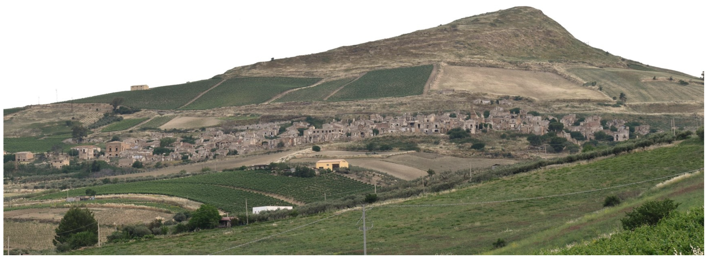
3], the town of Poggioreale is characterised by an orthogonal urban layout defined by regular road axes laid out on the steep southern slope of Monte Castellazzo, also known as Elimo (
Figure 1). The regularity of the roads that intersect perpendicularly thus determines a built-up area constantly standing on a slope, with a consequent variability of the blocks’ heights and aggregating modes. The heart of the settlement is Corso Umberto, the main axis of the centre, wider than the other streets.. It leads to the large Piazza Elimo, which, by replicating the uniformity of the layout in its rectangular and slightly sloping shape, is the fulcrum for observing the panorama of the southward valley and of the main church uphill, now in a state of ruin, [
4].
In its short lifetime, this small Sicilian town had progressively seen its urban fabric enriched with community services and places in line with national history [
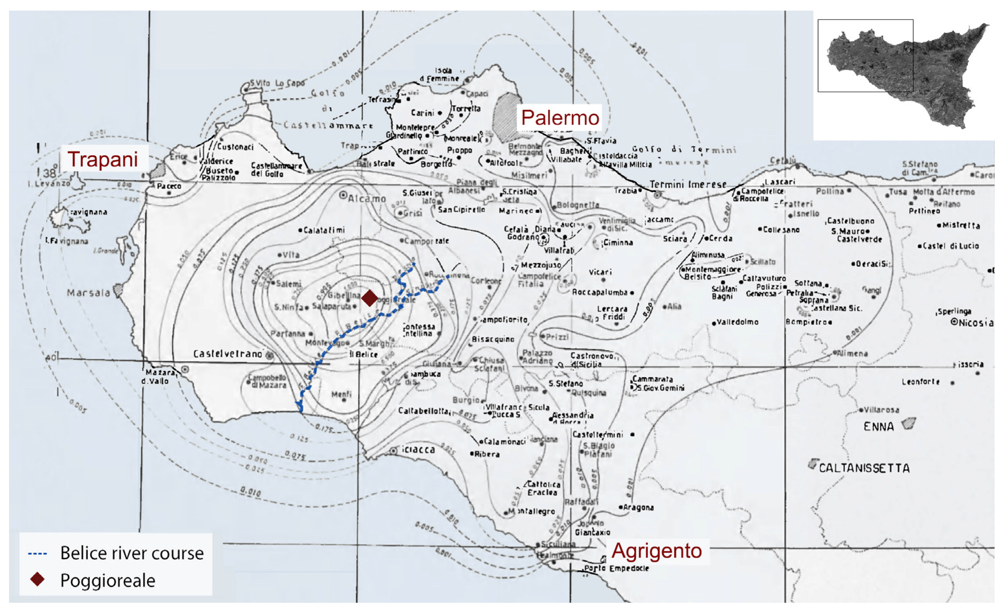
5], thus adding what was required by the new ways of life (town hall, theatre) to the already existing buildings, and then later, by the renewal of emerging activities (market, school) as well as the development of residential buildings within the urban perimeter, hosting a growing population. The seismic sequence that devastated the Belice Valley in January 1968—affecting an area of western Sicily covering more than 5500 km
2—led to the severe damage or substantial destruction of 14 of the centres of feudal origin in the territory (
Figure 2). In the aftermath of the disaster, a generalised line of intervention based on the delocalisation of the most damaged towns in the valley [
6,
7,
8] marked the destiny of Poggioreale itself, identified since then as Poggioreale antica—in order to distinguish it from the new town established three kilometres further south. The original 17th-century settlement was thus abandoned, creating a snapshot of a post-earthquake scene with unquestionable evocative qualities to which the locals are still inextricably linked [
9].
Half a century after the event that created it, that scenery has become a ruin stripped of its material essence, whose inexorable physical weakening has decreed the definitive loss of the memory of the life that once existed there. Over the last few years, a new interest in the old centre has emerged from the local administration and others who see opportunities— in the sense of a re-vitalization of the neighbourhood —in preserving and enhancing what remains of Poggioreale antica.
This renewed interest stems from the growing attention paid in recent years in Italy to small, abandoned centres [
10,
11,
12], not infrequently driven by economic expectations [
13], that recognise the heritagisation of these sites as assets and a springboard to local development [
14]. The initiatives undertaken on the theme of small towns and historical settlements’ abandonment (SNAIs) recognise the identification of cohesive strategies with the aim of achieving a compatible re-use of abandoned historic buildings as one of the main problems [
15]. In this perspective, the case of Poggioreale lends itself as a significant example for the thickening of a series of initiatives that identify it as a suitable place to host a defined, recognisable function of international scope.
The current study of the historic centre is framed in this context of renewed interest in ruins and originates from a recent agreement between the Sicilian Civil Protection Department and the University of Catania. The results presented herein, albeit embryonic, allow some initial analyses and reflections, with the twofold aim of seeking a collocation of the singular example of Poggioreale within the complex Italian issue of abandoned towns, and trying to outline some general criteria for defining preservative actions that value the site not only as a place of cultural consumption [
16,
17,
18].
Starting with a description of the earthquake of 1968 and its main effects on the area, the paper focuses on the current condition of the settlement and the results of ongoing research.
2. The 1968 Earthquake and the Choices for Poggioreale
In the late morning of 14 January 1968, a few tremors of moderate intensity triggered the seismic sequence that reached its climax on the night of 15 January with an Mw 6.4 shock with epicentre within an ideal polygon identified by the municipalities of Gibellina, Poggioreale, Salaparuta, and Montevago. The seismic event represented the largest natural disaster in Italy—except for the Vajont disaster in 1963—since the two world wars [
19]: the toll was around 300 victims, a thousand injured, and over 70,000 displaced [
20,
21].
The expeditious analysis coordinated by the regional office of the ‘Genio Civile’ in the immediate aftermath of the earthquake was aimed at estimating the effects on the built heritage, and revealed the severity of the situation. Surveys conducted in 127 municipalities in the provinces of Agrigento, Palermo, and Trapani [
22,
23] recorded the following situation: approximately one-third of the existing buildings had collapsed, including those slated to be demolished for safety reasons due to their severe damage; a quarter of the buildings had been seriously damaged to the point of being uninhabitable. In the concluding report, regarding the four worst damaged centres, there was an emblematic consideration through which to understand the subsequent relocation choices that would be adopted in a very short time to manage the disaster: “[…] The towns of Gibellina, Salaparuta, Poggioreale and Montevago have suffered total destruction, and all that remains of them is a shapeless heap of rubble, twisted beams and crumbling walls. Reconstruction on site will be impossible: just clearing the rubble would entail useless, hard work” [
24] (p. 372).
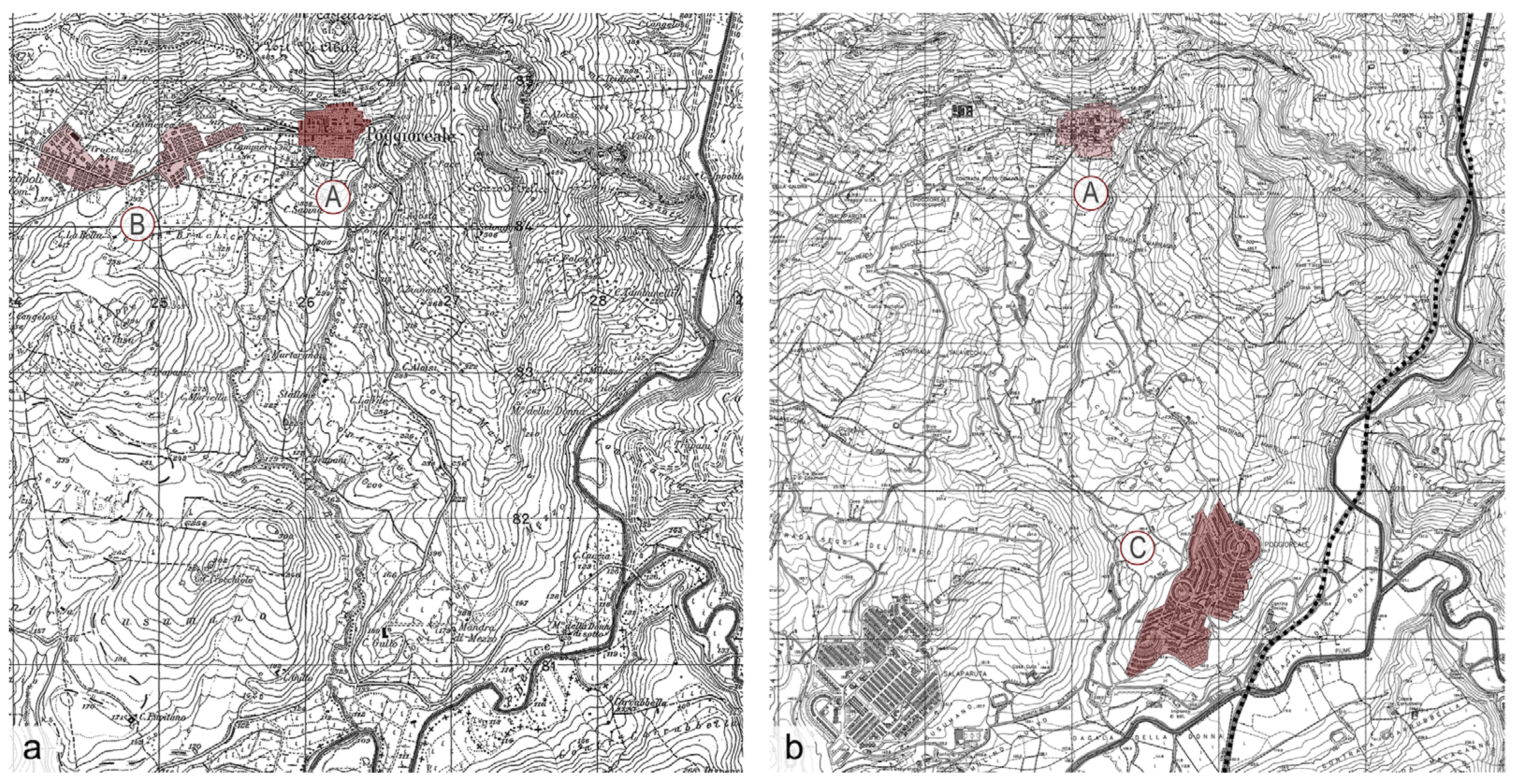
It was on the basis of these conclusions, therefore, that along with the town of Poggioreale, the settlements of Montevago, Salaparuta, and Gibellina were relocated; the latter even more than 7 km away from the original settlement [
25].
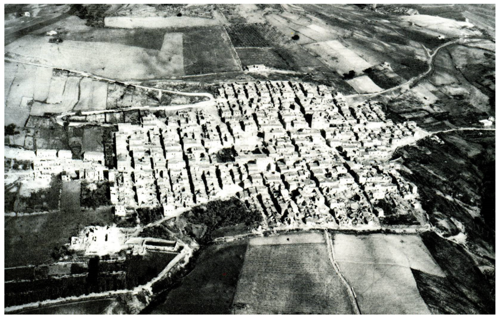
However, the description of Poggioreale in that report was completely inconsistent with the actual damage conditions. Indeed, the urban fabric, although severely damaged, showed only sporadic collapses in the aftermath of the earthquake: a circumstance that emerges firstly from some images depicting the post-seismic condition of the town (
Figure 3), but which can still be seen today. After more than fifty years of abandonment, during which, the action of time progressively amplified the effects of the earthquake, provoking endless small and large partial collapses, the building fabric and the road system are still conspicuously recognisable, as shortly described in the following.
While the aforementioned report identified all 993 building units surveyed in the village as being in a condition of total destruction, in reality, it is plausible to attribute a state of severe damage only to 30% of the existing buildings due to sporadic total collapses [
26].
The decision to move the population to a centre to be founded from scratch was therefore taken in the same way as in other towns that had suffered considerably more significant damage [
27]. This inconsistency is partly motivated by the conditions of social and economic backwardness that characterised the centres of the Belice Valley—which had already been subject to a slow but steady demographic decline for several decades [
28,
29,
30]—and by the illusory promises of redemption offered by the idea of a new city designed according to contemporary urban projects [
31]. Unlike the old Poggioreale, that idea seemed strictly compatible with the objectives of industrial growth identified by the Italian National State for the development of the areas of southern Italy [
32,
33].
The population was immediately moved to an emergency camp a short distance from the town, where they lived for more than a decade in tents and then in temporary metal houses [
34]. As the new city began to take shape with the construction of their houses, the relocation caused a slow but inexorable detachment from their family houses over time. A consequence of technical and, to a large extent, political considerations, old Poggioreale was also forcibly forgotten by the community, who had to abandon it to concentrate their energies on building a new life in a new place [
35] (
Figure 4).
3. Outcomes of Abandonment: The Current Condition
Lacking any reflection on the actual need for total relocation and within a climate of tragedy in which many priorities had to be faced, the fate of the damaged centre was not discussed at all, thus freezing the state of the places in a snapshot of the late 1960s. This makes today’s old Poggioreale a ghost town immersed in an almost preserved landscape. The still-noteworthy consistency of most of the buildings that compose the settlement contributes to maintaining that identity bond which was painfully compromised by the seismic event.
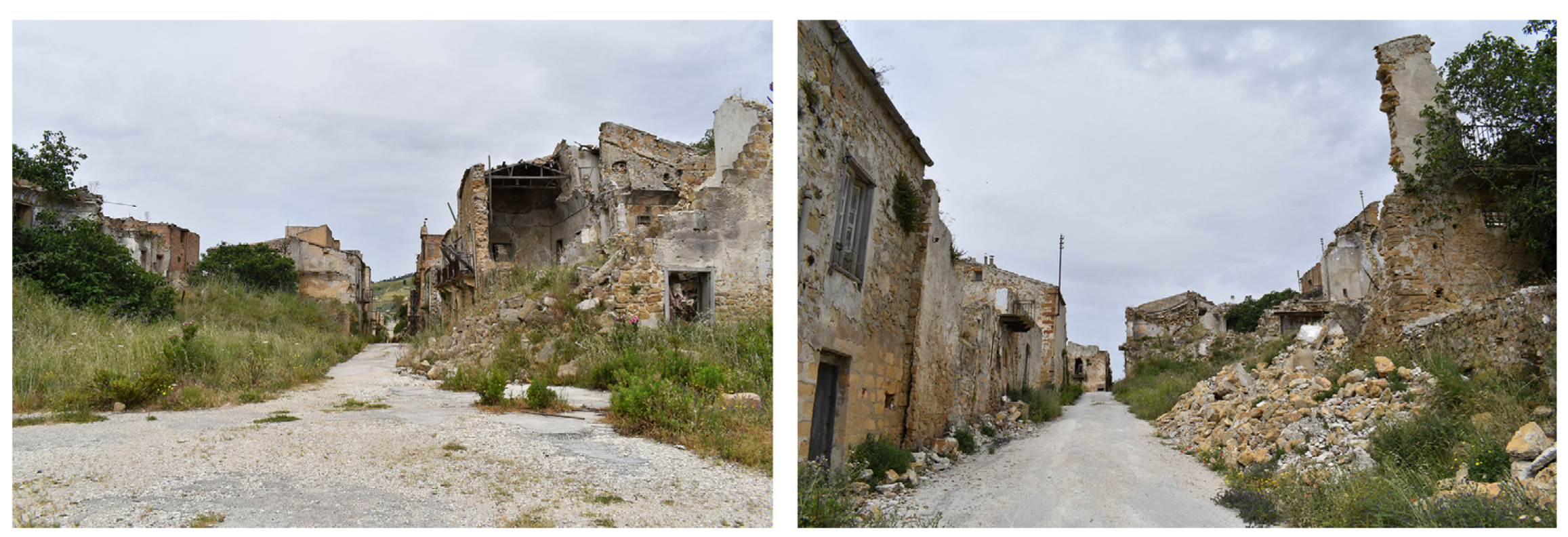
Upon entering the town—access to which is now forbidden—from the west, one immediately finds oneself in Corso Umberto, the centre’s main street, on which the buildings characterised by the most outstanding constructional and architectural qualities overlook. They thus represent a good part of the best-preserved buildings in the centre; however, even on the Corso, there are clear signs of the persistent state of neglect, as shown by the sometimes substantial collapses that lead to the accumulation of rubble along the road. Together with the more general conditions of the existing structures’ progressive deterioration, the more specific effects connected to the lack of maintenance of the rainwater channelling system should not be overlooked (
Figure 5). Significant rainfall causes considerable quantities of water to flow along the axes perpendicular to the Corso—in some points, steeply sloping—dragging mud, debris and, sometimes, portions of the walls themselves downhill.
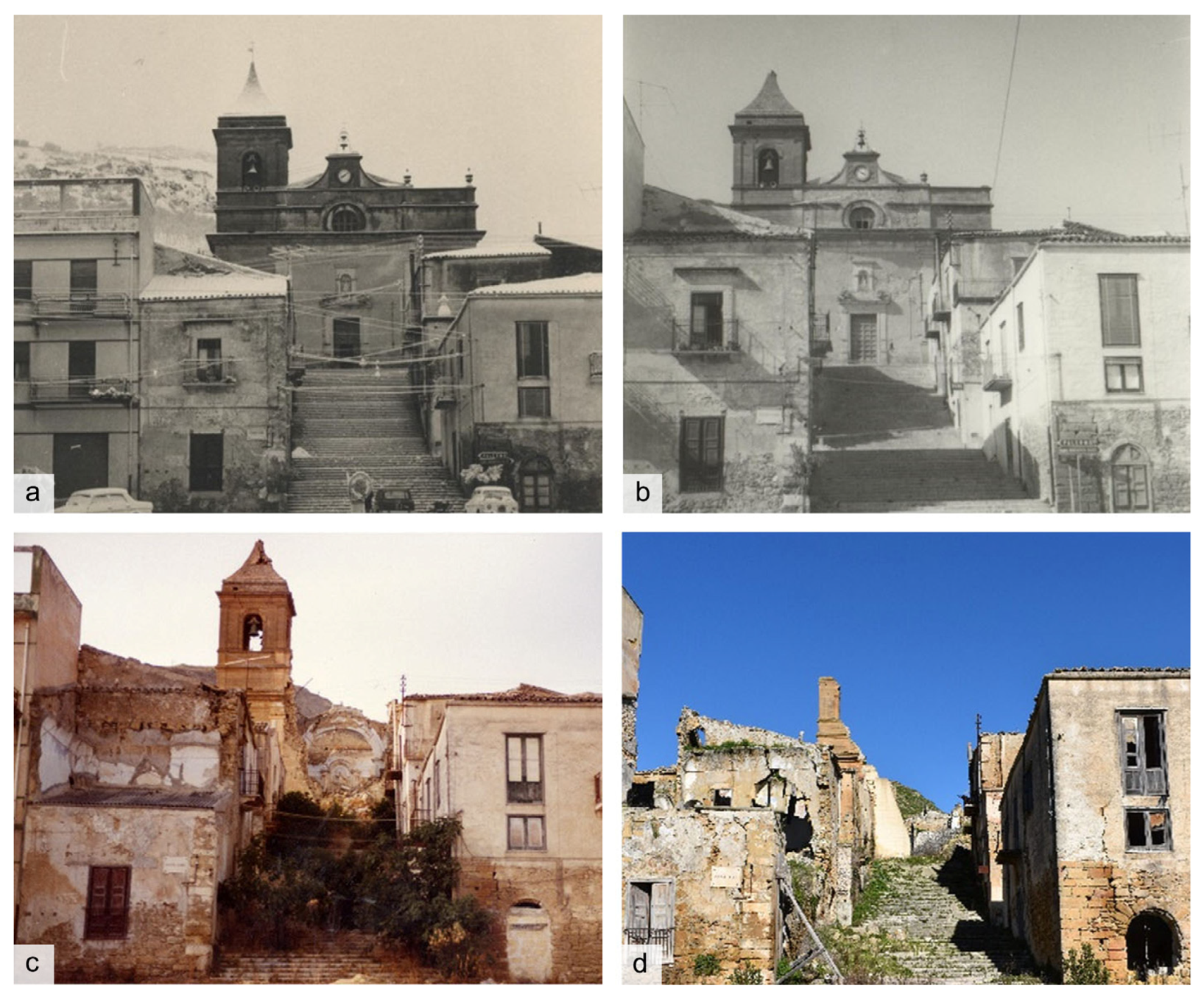
Corso Umberto enters the Piazza Elimo from the longer side; the square is a long ample rectangle, sloping towards the valley and with a monumental backdrop uphill formed by the imposing façade of the mother church. The earthquake damaged the church, sparing the façade where only a few isolated cracks appeared, as can be seen from some images from the days immediately following the earthquake (
Figure 6). However, only limited portions of the church are left today, due to collapses over the years and demolitions for safety reasons—indicated by the stone elements still accumulated near the building. Part of the 19th century bell tower, the only structure that survived in the decades following the earthquake, collapsed disastrously in 2009. What remains of it—the subject of a strengthening project in 2012—now constitutes the last identifying element of the original backdrop that defined the northern side of Piazza Elimo.
Except for two blocks, of which only the footprint is left on a weedy ground, the space of Piazza Elimo is still perfectly defined, and the visual channel produced by the surviving downhill blocks still offers a significant view of the valley’s landscape.
Gradually moving away from the Corso and the square, the conditions of decay briefly outlined so far become more pronounced. In addition to the blocks that no longer exist at the settlement’s northern, western, and southern extremities, numerous secondary roads are inaccessible due to piles of rubble on which dense, weedy tree vegetation have not infrequently taken root. In these more compromised parts of the building fabric, it is sometimes possible, in limited portions, to observe traces of public paving made of dressed stone and river pebbles.
4. Threats and Opportunities Today
After several decades of oblivion, some ideas and actions involving the fate of the abandoned village took shape, beginning in the second half of the new century’s first decade. The municipal administration undertook an initial series of actions, drawing inspiration from some experiences carried out in central Italy since the end of the 20th century, in which authorities repurposed ancient small settlements of increasingly abandoned inter-neighbourhood areas as receptors for tourism (see, for example, the case of the diffuse hotel in Santo Stefano di Sessanio [
36]).
With this perspective and with the aim to define a strategy for the enhancement of the territory, whose main attractive fulcrum was the re-functionalisation of the abandoned centre, the Municipality promoted the elaboration of a plan program with the primary objective of making the main streets of the built-up area accessible, thus allowing the safe enjoyment of at least the main parts of the centre, Corso Umberto I and Piazza Elimo.
Following this plan program, the municipal administration included a programmatic document called the Charter of Values and Quality in the municipal building regulations [
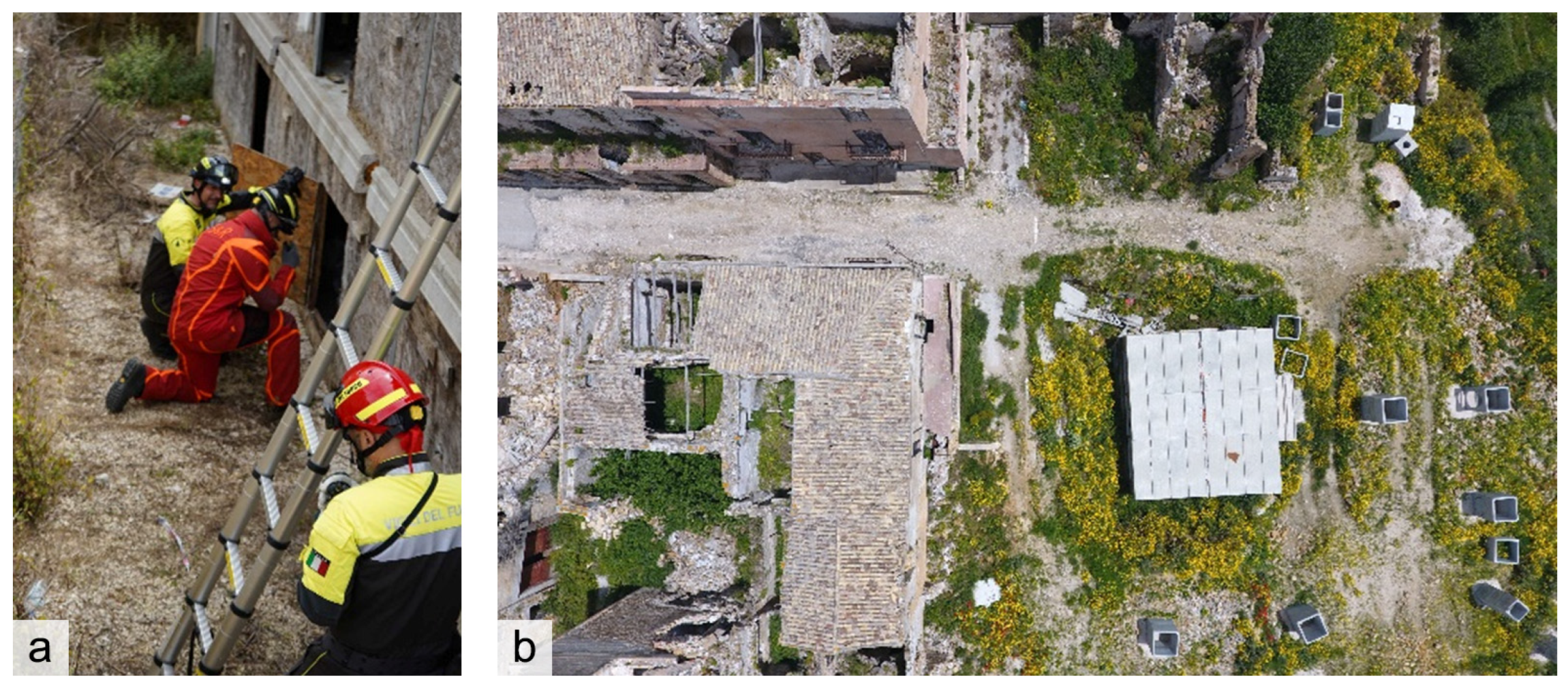
37]. The ten points of the Charter illustrate strategies and actions that should be implemented to spark economic development aimed at enhancing the ancient centre through urban and architectural conservation, within a more general policy of landscape protection. However, the action to be conducted on the built-up area of the centre reveals a primary purpose of functional reuse whose definition, moreover, results from a rough reading of the urban fabric and its condition of conservation. The zoning approach of the document provides for: (i) a park museum of historical memory in the most compromised part of the built-up area (to be implemented through interventions aimed at the elimination of dangerous conditions, and with prescriptions for the preservation of the identifying features of the urban fabric, building types, and construction techniques); and (ii) residential, tourist-receptive, commercial, and artisan functions in the central areas, including Corso Umberto, together with its uphill blocks, and Piazza Elimo. Except for the built-up area facing the central axis and the square, for which strict compliance with the architectural, typological, and constructional characteristics is required, the interventions have been categorised as “regulated transformation”. From the structure of the operation, which was not implemented due in part to a lack of funds, it was clear that the search for an economic enhancement was predominant but not supported by the demands arising from the territory. It is worth mentioning that the new town, built merely a short distance downhill of the old one, is largely oversized with respect to real housing needs; at present, that implies several difficulties in management and maintenance for a small municipality which is called upon to face expenses that cannot be easily recovered. What emerges from this situation is that an enhancement of the municipal building heritage—that of the so-called “ruins of Poggioreale” as well as of the new town—can only be undertaken within a unified vision that includes the two parts in the same future perspective. A second line of action, strictly operational, is the one that in more recent years has identified the abandoned village as a venue for international educational exercises of ‘real-life’ post-disaster rescue simulations coordinated by the Italian National Fire Department. In October 2016, in the streets and inside the abandoned buildings of Poggioreale antica, an operational training course—Modex Sicily 2016—was organised in cooperation between the Municipality of Poggioreale and the National Civil Protection Department. The course, incentivised by the European Commission [
38] and supported by the European Council, aimed at building cooperation for emergency and humanitarian crisis management (
Figure 7).
The success of the operation, affirmed by all participating entities, triggered the will to repeat the experience three years later. To this end, in 2017, a memorandum of understanding was stipulated in order to regulate the activities to be carried out in the area of the Poggioreale ruins. In fact, the interest of the NCP Department has meanwhile been flanked by the protection needs witnessed by the entry into force of the Landscape Plan and the indications it contains for the site called “ruins of ancient Poggioreale”. The site, subject to the maximum level of protection, is considered: “[…] an area of exceptional historical importance that also needs to be recovered through virtuous and innovative processes of interaction and coordination with other institutional actors to achieve increasingly comprehensive training in the protection and recovery of cultural heritage” [
39].
After decades of oblivion, the abandoned village went over the course of a few years, from being unknown outside the narrow circle of its territory to being the focus of international interests (albeit limited to the specific field of civil protection) and of a formal request for conservation. In 2018, a working group was formed to make final plans for the second edition of the international training course for search and rescue teams—Modex Sicily 2019—and to carry out the preparatory works «respecting the places of memory and … the integrity of the ruins and their protection from decay» [
40].
The inspections carried out for this purpose highlighted the need to perform provisional interventions to secure the internal road system so that the international exercise—scheduled between 16 and 19 July 2019—could take place safely, all while enabling guided tours aimed at learning about the site and its historical and cultural heritage. Thus, there emerged, on this occasion, an awareness of the worsening decay of the ruins (further collapses and incipient instabilities) and, at the same time, the discovery of a slight interest expressed by a niche tourism interested in the beauty of the landscape and curious about this silent and fascinating wreck.
The time now seems to be ripe to define an objective that more concretely starts from the reality of the place and aims at its preservation by foreshadowing different functions that are compatible with current conditions and are not mutually conflicting. The spontaneously emerged synergy between the interests of civil protection and that of cultural enjoyment makes it possible to prefigure a path of active preservation to be pursued medially through a mixture of operational and contemplative use, also aiming at mending memory.
The first of these two types of uses—operational use—sees the abandoned village as a place repurposed as a venue for activities connected to managing natural disaster emergencies, and for scientific initiatives aimed at preventive seismic protection of the historically built heritage. Based on the vision expressed in the landscape plan, the second one—contemplative use—promotes the expanded use of the entire centre as an open-air museum, capable of telling its story and, in perspective, that of its territory. The latter implies an operation of collecting the small material and immaterial fragments still visible among the ruins or in the memory of those who lived there before the earthquake.
While operational use could provide an opportunity for reintegrating the village into a vital circuit of relationships, making it a supranational point of reference, contemplative use would allow the achievement of a twofold purpose: creating a place for the local community’s collective memory, which was abruptly interrupted by the earthquake, and identifying the ruins as part of a landscape to be protected to ensure the transmission of that very memory to the future.
5. The Ongoing Research
The only way to understand a place and its historical and material condition, thus imagining possible actions for its preservation, is to acquire an in-depth knowledge of it. The study opportunity for Poggioreale started from the request made in 2020 by the Civil Protection Department of the Sicilian Region to the University of Catania with the specific purpose of defining the criteria for the conservative securing of the urban fabric in agreement with the municipal administration [
41,
42].
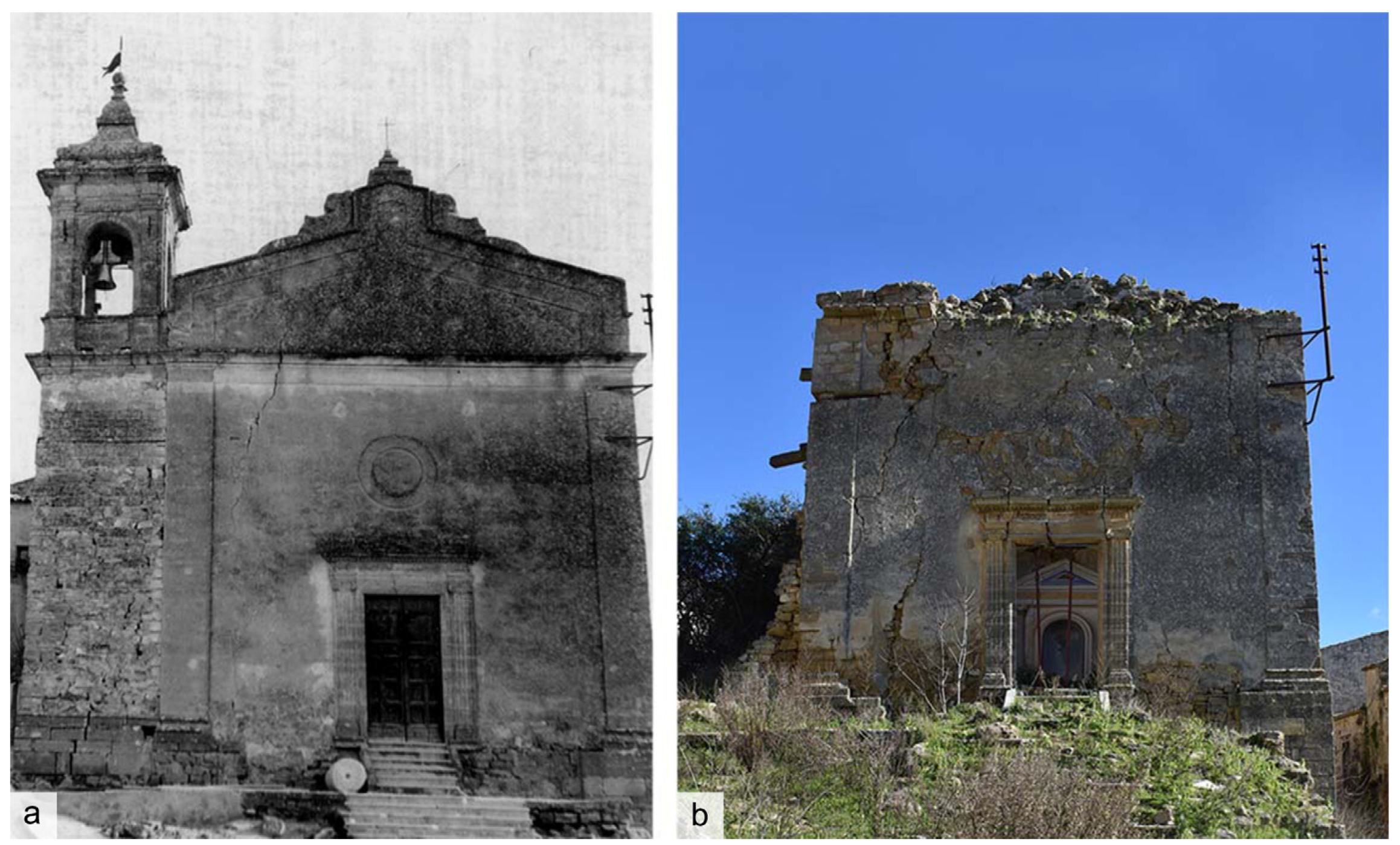
To this end, the analysis focused first of all on mapping the reduction in the physical consistency of the built-up area due to the progression of decay in the fifty years since the earthquake, with the objective of simultaneously highlighting the permanence and recognizability of both the urban layout and the building massing. The relocation of inhabitants has allowed the persistence of damage situations typical of post-earthquake contexts (isolated, potentially unstable walls, masonry cells disconnected by cracks jeopardising the box structure, etc.), which have gradually worsened over the decades. The progression of damage and the involvement of an increasingly greater number of elements is evident when historical and current images are compared (
Figure 8).
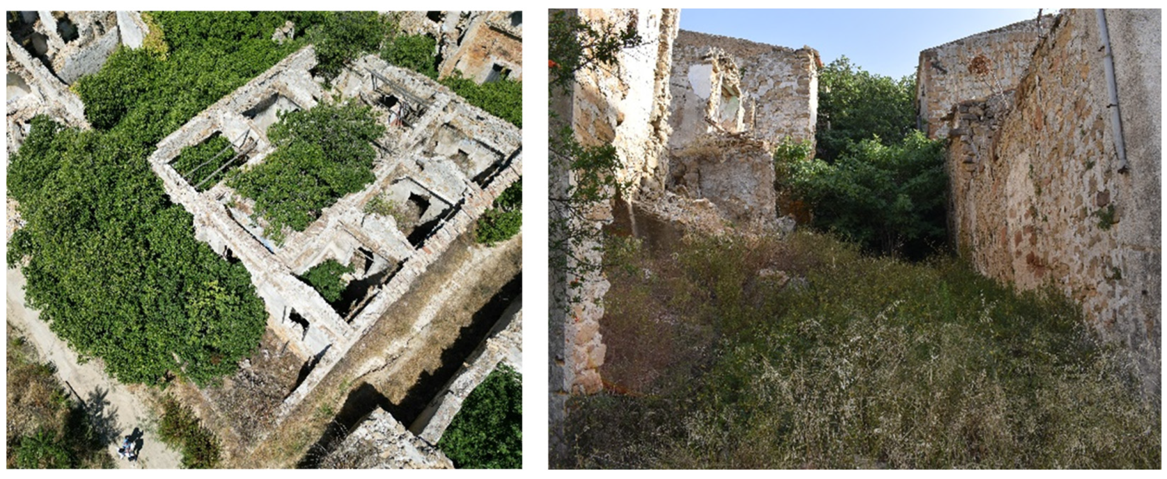
The first cognitive objective was identified in constructing a map extended to the entire urban fabric capable of sufficiently describing the conservation stauts of the wall structures. Despite the difficulties due to the vegetation rooted on the streets and inside the ruins of the houses (
Figure 9), systematic fieldwork made it possible to acquire all the significant information [
43].
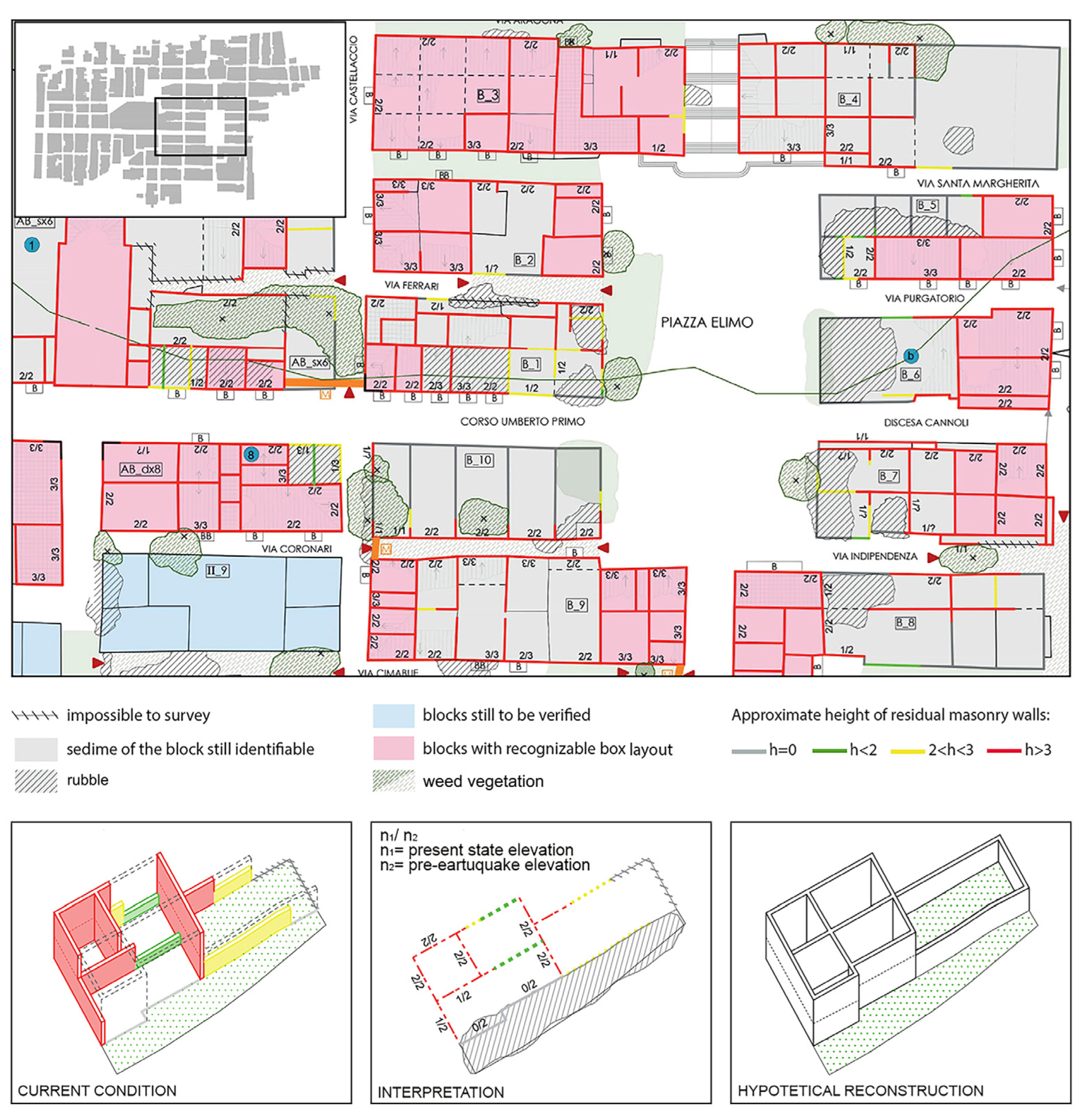
The obtained result is the “present state map” (
Figure 10)—implemented on the cadastral map—which defines for each building the number of surviving levels in relation to the original ones; it provides an approximate estimate of the height of the still in situ elevation walls (expressed in metres) and identifies the units maintaining a recognisable box layout (with walls of comparable height still standing on all four sides, possibly connected—even partially—by the roof). The weed vegetation, divided between shrubs and trees, is also located together with the rubble and stone objects accumulated with a view to their conservation or use.
The map was built as a tool for the critical reading of the site’s material reality to facilitate the identification of conservative intervention choices by highlighting intervention priorities. The thematic collected information highlights the recurring problems and suggests the selection of areas to be analysed in detail for in-depth study.
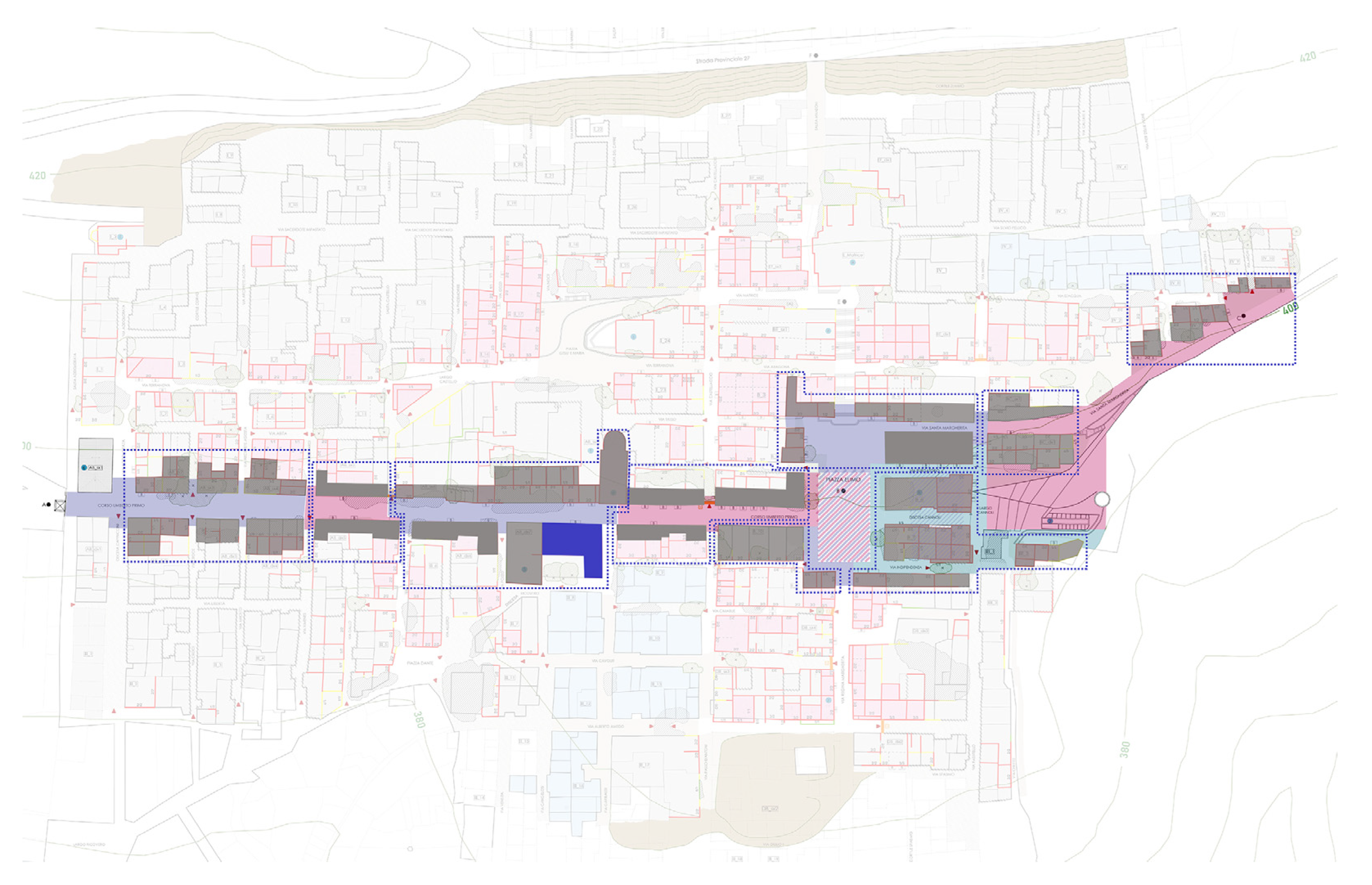
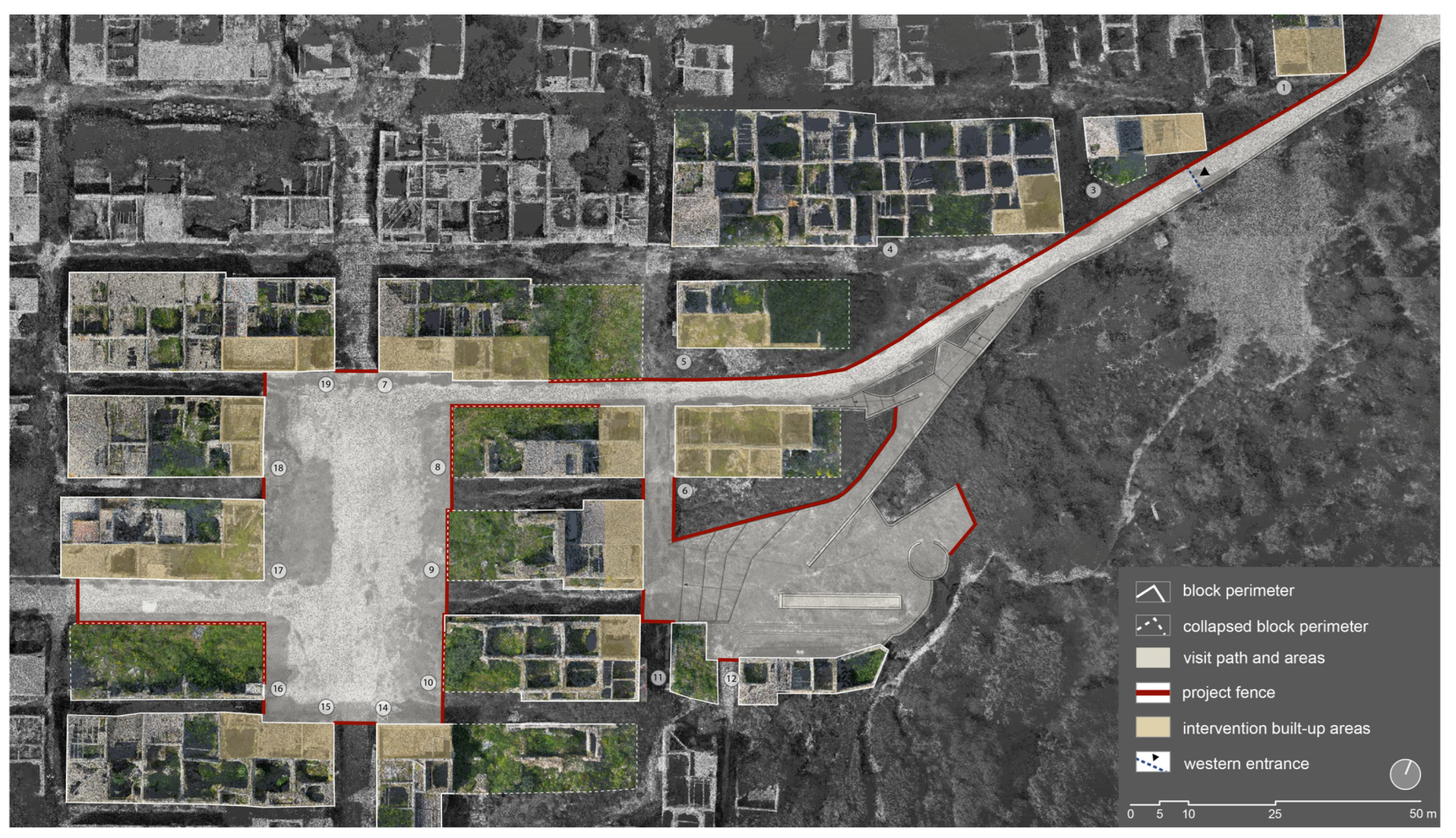
On the basis of the information gathered in the map and some discussions with the municipal administration, the central axis (Corso Umberto I—Piazza Elimo—Via S. Margherita) was recognized as the area to be prioritised for a more detailed analysis, with the aim identify the possible strategies of intervention for the controlled opening of some portions of the centre to visitors.
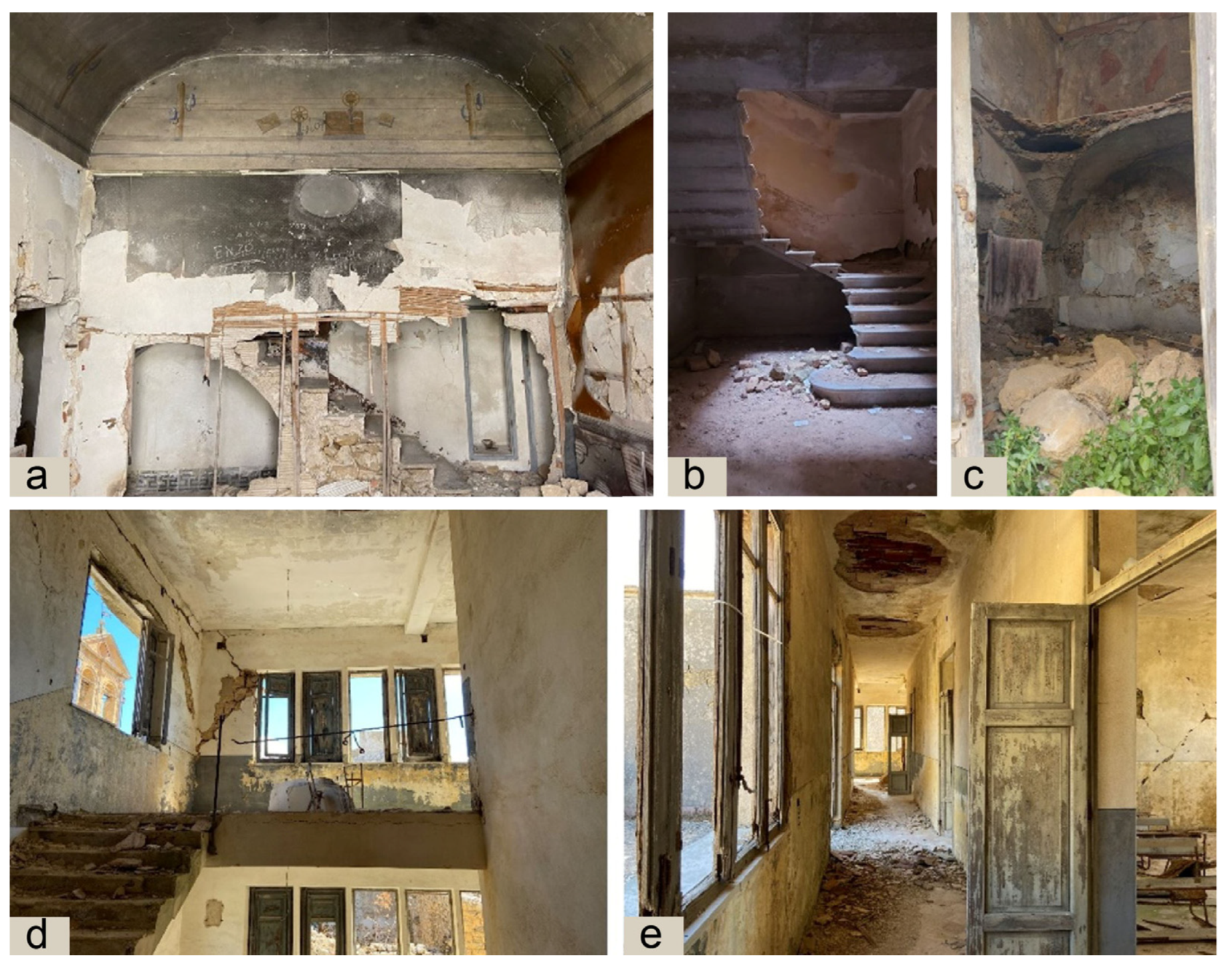
Using both a laser scanner and a drone to acquire data on the buildings facing the selected routes, the study was driven mainly by field observation focused on identifying the hazards deriving from the damage condition of the façade walls. These were carefully examined with regard to potential overturning mechanisms and possible local collapses that could represent critical conditions for the practicability of the road axes. The rubble was also investigated to highlight its relationship with the stability of the adjacent wall structures.
The combined reading of the information obtained from the preliminary mapping and the second-level analysis gave rise to some considerations regarding the degree of compromise of the structural layout and residual legibility of the urban fabric.
First of all, the overriding and inescapable issue of securing the routes—a mandatory step to enable interventions in the settlement’s body—takes on a more complex articulation than that associated with structural aspects alone and intersects more properly with preservation issues. In fact, many of these emerged during the inspections.
The first method is to eliminate or limit alterations resulting from activities which are not in accordance with the primary goal of protecting Poggioreale. These are, for example, the activities related to the site’s use—albeit sporadic—for rescue simulations, which result in obvious irreversible alterations to the building fabric and amplify the progressive loss of its material substance. If an operational use is necessary to provide a reason for preservation and to support memory recovery, the choice to settle an international school of civil protection is significant for the possibility of planning and designing educational and experimental activities (
Figure 11). The educational activities should take place in a suitable location, wherein the first phase of implementation should certainly be identified with the existing buildings located in the new city, while the experimental ones should be confined to some specifically identified areas of the urban fabric. From this premise, it emerges how the action to be undertaken for the physical conservation of old Poggioreale is certainly dynamic both in time and in the involvement of different categories of stakeholders, starting with the local and territorial community: a complex path, the completion of which requires multiple experts’ and stakeholders’ support in conserving this place of memory.
A second consideration concerns the very meaning of “securing” in the specific context of Poggioreale. Compared to the solutions usually adopted in post-seismic emergencies, which provide for provisional works to be removed in a reasonably short time (to start the repair and reconstruction works) and which, therefore, are exclusively aimed at preventing the collapse of buildings, any intervention to be undertaken here must instead be aimed at the same time at the safe use of the centre and at the material preservation of the building fabric. Interventions should not only ensure the stability of the surviving portions, but also allow typological, constructional, and formal recognizability. In this sense, the idea that seems to recall the situation of Poggioreale today is closer to that of large archaeological sites (think of the excavations of Pompeii or ancient Ostia) where interventions of securing and restoration coexist to allow not only the enjoyment of the places, but also, in part, the experience of the lives that took place there.
From this viewpoint, involving the building bodies in the securing of street frontages—when possible—could not only make the structural intervention simpler, but could also make cultural use more meaningful. This would in fact allow for extending the walkable area of the restoration to some of the interior spaces, whether these be the ground floors of the houses, the courtyards, or the voids within the blocks, in the manner typical of archaeological contexts (
Figure 12). This could perhaps foster the reconstruction of lost memory that now appears as an identifying feature of this forgotten place.
Moreover, concerning the more compromised central blocks, where it is already difficult to even distinguish between areas covered by buildings and streets, there is a need to consider the possibility of a philological intervention aimed at developing technical solutions to highlight the layout of the walls of the buildings.
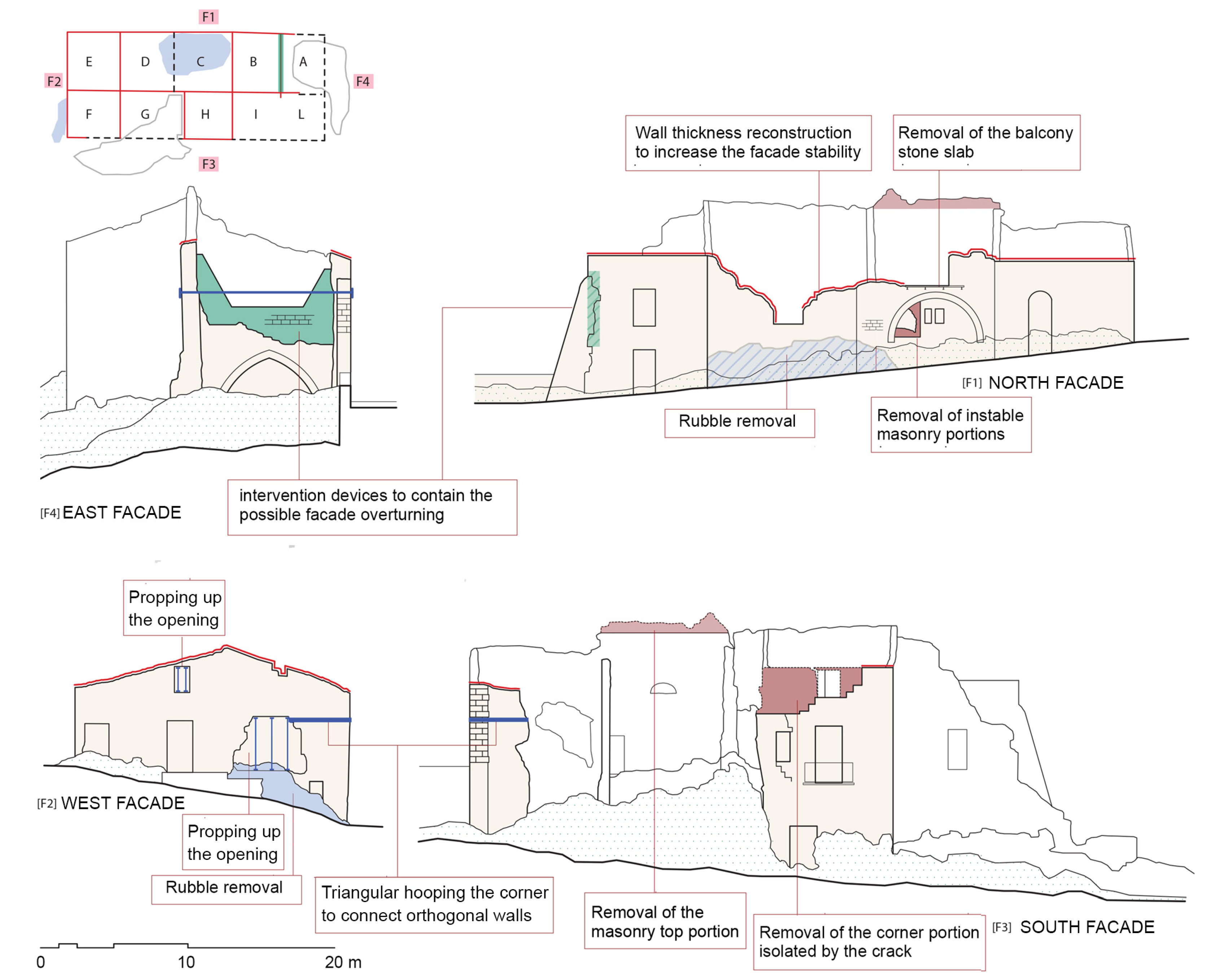
An initial pilot project has been drawn up with the main aim of preventing possible collapses on the roads that will be open for visits. It is intended as a preliminary step towards defining a specific objective for protecting old Poggioreale within a global vision of its future (
Figure 13 and
Figure 14) based on the belief that the action of “protection” can only occur when knowledge of a place is extended to as many people as possible. Thus, the most important intervention in this regard is enabling the possibility of physically walking those same roads and acquiring that knowledge.
The specific purpose of the project is therefore to allow visits following specific rules defined in relation to the general conditions of the site and the higher purpose of protection (intended here as the balancing act between carrying out as few modifications as possible and opening the area to visitors). The implementation of the project makes it possible to gain time for the construction of a shared strategy on the future of the Poggioreale ruins and to define the understanding between generations for the survival of a testimony necessary for the community’s life.
6. Conclusions
It is reasonable to state that the hypothesis of bringing the ancient centre back to life by inhabiting it anew does not appear as a possible solution. Instead, the material survival of the centre could be linked to a different, partial, use of the buildings, still respectful of the ancient structures.
The current condition of the built-up area, in addition to not allowing safe use and enjoyment, is gradually causing the loss of even the memory of the places symbolic of the lives that took place there. Therefore, another significant operation is the need to broaden the extension of preservative operations from the material to the intangible values that can still be brought to light. To perform this, future interventions should also consider guiding the visitor in understanding how the centre was experienced by the inhabitants who were suddenly forced to abandon it. The effort to convey the pre-earthquake functions of some symbolic buildings would allow for a timely and meaningful evocation of the memory of the place, the ways of life at the time, and the habits of the community. The conservation activities could then allow for a documentation of all the constituent aspects of this forgotten place.
Hence, the authors present the idea of a conservation action that uses the recovery of memory as a model of experiential use. In this model, the constructional theme also acquires more complex implications: the knowledge of ancient building techniques is not only essential as a guide for consistent restoration strategies, but can also be exploited, in a more general sense, in its historical documentary nature, enabling the possibility of recovering, in their broader meaning, the symbolic places of the community.


 ,
, 


