1. Introduction
Cultural Heritage (CH) sustainability has been recently introduced to the SDG 11 “Sustainable cities and communities” of the UN Sustainable Development Agenda 2030 to describe the significant relationship between conservation and sustainable development [
1]. Target 11.4 aims to “strengthen efforts to protect and safeguard the world’s cultural and natural heritage”. Conservation of CH plays a significant role in sustaining local communities, not only reinforcing local identity and traditions, but also, in maximizing economic benefits through well-managed tourism. Heritage trails are CH assets of significant historical and cultural value that are worth being preserved. A heritage trail typically refers to a designated route or path that showcases and highlights the historical and cultural heritage of a particular region or community. Depending on the types of features and landmarks it may include along the designated route, it can be characterized as historical, cultural, foot trail or bikeway, interpretive/natural trail, multi-use trail, etc. A historical hiking trail entails sites of significant historical importance or showcases events that have shaped the region’s past, such as battlefields, monuments or statues commemorating historical figures, or museums showcasing artifacts and exhibits from a particular time period. The protection and expansion of linear CH sites has received an increasing amount of attention, as it allows for the possibility of resolving contradictions between the economic and market values of tourism and sustainability [
2]. Heritage trails may also combine cultural heritage interest with sites of significant biodiversity and natural beauty. SDG 15 “Life on Land” and the more specific Targets 15.2, 15.4 and 15.9 emphasize the need for sustainable management of all types of forests, for conservation of mountain ecosystems, including their biodiversity, and for integrating ecosystem and biodiversity values into national and local planning, development processes, poverty reduction strategies and accounts. For the successful implementation of the above-mentioned goals, the role of geospatial infrastructure is highly appreciated. Geospatial infrastructure ensures evidence-based, sustainable planning and smart management of trail networks and the greater area; it provides updated and reliable information for decision-makers, local authorities and planners but also for visitors who may easily retrieve information about the historic and biocultural data, but also about the difficulty of the trails, the type of trail, the marked trail designations, social trails, as well as information about hazards, dangerous conditions, if any, and guidelines on how to hike smartly and stay safe.
This paper presents the creation of an innovative geospatial tool dedicated to the redevelopment, rehabilitation and sustainable management of historic trails of various levels of difficulty and thematic categories. Its innovative features contribute to effective planning, decision-making, and user engagement in the context of eco-tourism and regional development. It supports any kind of data that derive from topographic surveying, photographic documentation, video recording of walking tours, metadata and extensive archival research. Different groups, such as local communities, urban and regional planners, government authorities and policy makers, etc., can contribute through crowdsourcing. The managers of the tool could review the contributions, validate the information provided, and incorporate it into a unique geodatabase as appropriate. This collaborative approach leverages the collective knowledge, experiences, and expertise of diverse stakeholders, to ensure that the tool’s functionalities align with the needs and aspirations of the wider community. The enriched geodatabase serves as a repository for the historic routes, where the GIS reference points trace them. The tool utilizes an object-oriented GIS-based model to integrate descriptive information into the corresponding vector spatial entities, mosaics and tabulated data. The geodatabase is enriched with multimedia content, such as text, images, videos, links, and charts related to landmarks, natural features, and points of interest along the trails. This integration allows for a seamless connection between spatial data (recorded routes) and descriptive data, such as historical or cultural information, enhancing the overall understanding and management of the trails. By performing map algebra operations, various geometric information related to the trails, such as path length and distances between points of interest, can be calculated. Moreover, the tool can identify and spatially locate issues along the trails, such as damaged sections, overgrown vegetation, and lack of amenities, such as signage or seating areas. Analyzing and mapping these issues facilitates targeted interventions and maintenance activities. Finally, the tool leverages ArcGIS Online (or any other web-based service) to disseminate the developed geodatabase. Its web application provides interactive 2D maps with features such as bookmarks, measurement tools, and search bars. It also includes pop-ups that display information and images about specific points of interest, as well as dynamic visualization of the vertical profile of each trail in 3D. The publication enables wide accessibility and engagement, provides comprehensive information for visitors or stakeholders, and effective planning and analysis of the trail network.
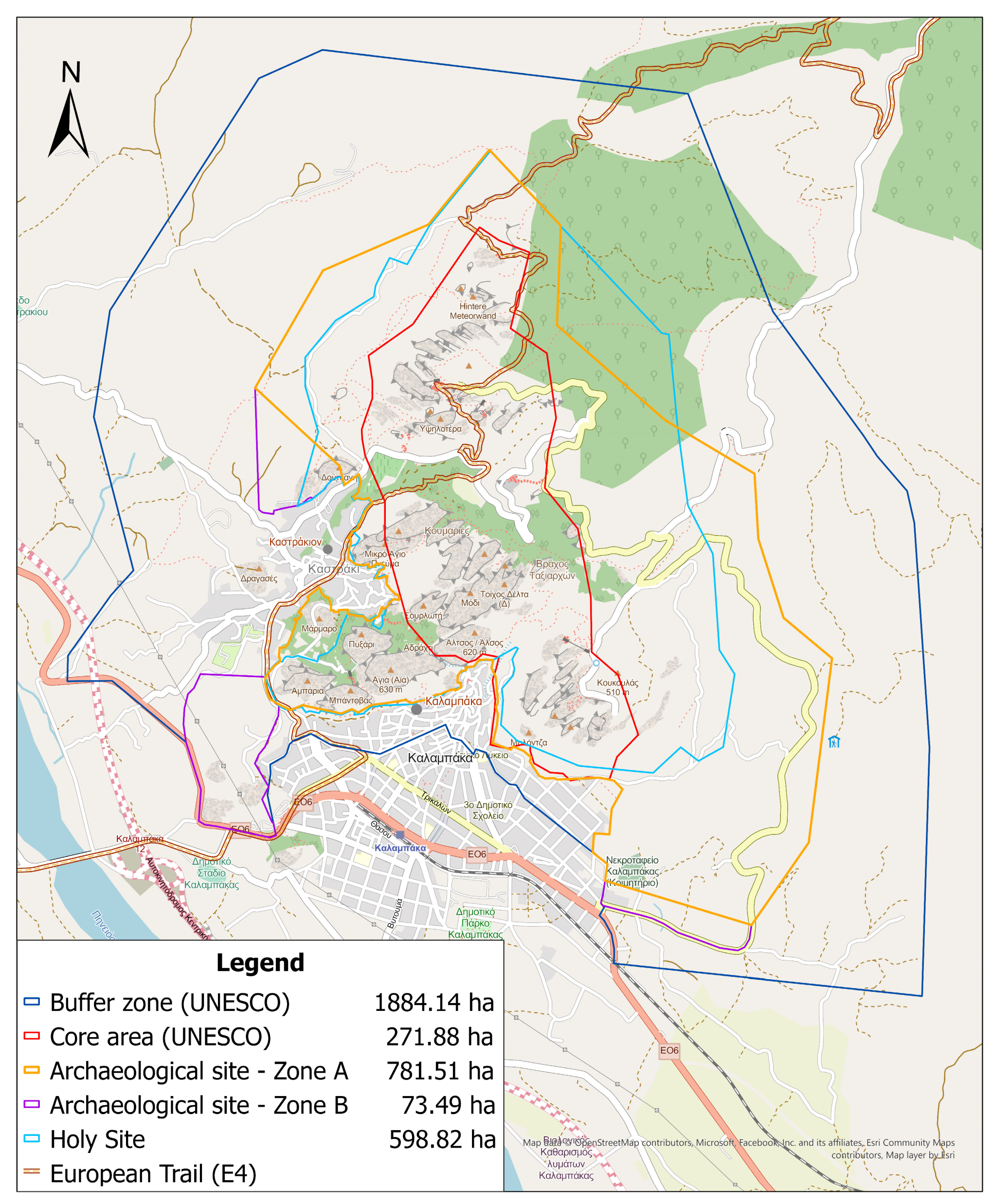
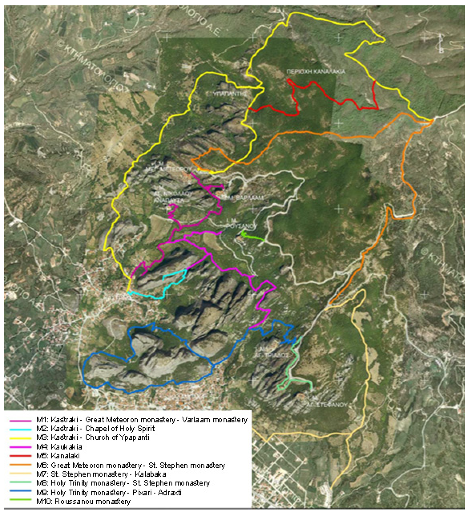
Thus, through data integration, spatial analysis, issue identification, and web-based dissemination, the tool contributes to effective planning, maintenance, monitoring, accessibility and user engagement for visitors, stakeholders, and decision-makers. Potential users of the geospatial tool for historic trails encompass tourists and visitors, local communities, heritage organizations, environmental and conservation agencies, urban and regional planners, as well as government authorities and policy makers. The proposed geospatial tool is tested and implemented on a network of ten historical walking trails of the UNESCO, archaeological and Holy site of Meteora, Greece [
3]. In this site, it is essential to manage the natural and cultural environment of the greater Holy area in parallel with safeguarding of the historical trails’ authenticity in a sustainable manner. The trail network, of a total length of 35 km, leads the visitors from the two neighboring settlements of Kalampaka and Kastraki to the six active monasteries. These CH routes constitute part of a broader trail network of various levels of difficulty and thematic categories across the whole Trikala region. It is part of the regional strategy and local government management models and constitutes a Master Plan for sustainable redevelopment, improvement and management through eco-tourism (walking, bicycling, adventure, cultural and other alternative types of tourism).
The article is structured as follows. In the following section, a comprehensive review of the literature is performed to identify similar approaches in spatial analysis and GIS infrastructures in the field of linear CH.
Section 3 concerns the requirements, concepts and methodology used for data collection, process, analysis and online visualization of the proposed geospatial tool.
Section 4 concerns the implementation of the tool. It documents the current state and presents strategic planning, including the description of the historic walking trails of Meteora, the proposed treatment and maintenance measures, as well as the procedures and results of data collection, geodatabase creation and web publishing. Finally,
Section 5 analyzes the significance of the proposed tool for sustainable monitoring and promotion for various stakeholders while
Section 6 summarizes the findings and proposes future work.
2. Literature Review
In recent years, many debates have taken place regarding the role of CH in sustainable development [
4]. The role of community in sustainable CH management has been highlighted at UNESCO conferences since the mid-1990s [
5]. Public participation is an important approach for achieving CH sustainability. While conservation efforts and co-operation from major stakeholders are inevitably crucial factors for CH sustainability, the active effort and participation of local communities actually determine whether relevant preservation actions may be successfully implemented, being essential for the success of CH conservation, as discussed in [
6]. However, CH sustainability is a complex issue that is rarely measured, mainly due to lack of universal CH sustainability indicators. Methods for measuring and evaluating CH sustainability are proposed in [
7]. The link between sustainability and historic environments is addressed in [
8], where the authors establish a framework for appraising sustainability in the CH sector, focusing on the available case study material.
However, interest in preservation of historical and cultural trails as opposed to urbanization and mass tourism has only emerged recently. While multiple similar quantitative method approaches have been conducted regarding the tourism value of linear CH in general [
9,
10,
11,
12,
13], only a few works in the literature demonstrate their value and impact through extensive documentation and spatial analysis tools. The most common and long-established technology used is the Geographic Information System (GIS). The Tambunan site was recorded and megalithic stones were mapped. Then, least-cost path analysis (LCPA) in GIS was used to identify cost-effective and sloping routes to produce heritage trails [
14]. An integrated GIS system for the organization and planning of two cultural routes in Chios Island, Greece based on in-situ observations and the study of the corresponding spatial and legal framework is presented in [
15]. Two GIS tools (Boolean algebra and logical operations) were exploited for comparative analysis among the descriptive characteristics of the elaborated thematic maps of the current state, the implemented interventions proposed in an older relevant study of 1999, and new proposals. GIS-based mapping techniques have been applied to evaluate two alternative itineraries for the Monks Route, that cross the agricultural landscape in southern Milan, with the aim to document their spatial features and rank them in relation to their spatial quality [
16]. These techniques form the SQISR method (Spatial Quality Index of Slow Routes) that also allows comparison of alternative routes on the base of a set of heterogeneous indicators.
Regarding GIS applications for decision-making in trails’ optimization, the variations is trail conditions, such as incisions caused by soil erosion, are related to their potential as influencing factors for the Nakahechi Heritage route by performing a series of multivariate regression analyses [
17]. After evaluating route walkability for people with different needs, accessible pedestrian networks between touristic attractions were created in Lisbon [
18] and in Faro [
19] historic city cores, Portugal. The diagnoses validate that the physical characteristics of urban cultural routes do not always comply with the requirements of the National Law of Accessibility, being unsafe and inaccessible to people with limited mobility. Moreover, multi-criteria analysis, including clustering and classification, is employed to identify the different typologies of the surrounding landscapes of the Via Francigena path in Italy and to promote sustainable tourism through rural planning [
20]. Three geo-routes in Santa Elena Province in South America were designed and generated as a result of SWOT analysis, revealing that geo-tourism development should be based on strategic planning [
21]. In the context of urban heritage trails, Advanced Spatial Analysis (ASA) techniques were applied to obtain a diagnosis of the existing spatial problems of Seville city, as well as the opportunities offered by the context [
22]. After recording pedestrian accessibility to assets and the concentration of tourist activity, mathematical, historical and sensory criteria were used to generate routes and balance the distribution of tourist flows. Compared to the aforementioned studies, this research studies multiple factors and incorporates both on foot and by bicycle metrics to serve as a reference for other tourist-centric historic cities. Finally, an operational GIS-based model for megaregional transportation planning has been developed analyzing the Texas Triangle (Austin, Dallas–Fort Worth, Houston, and San Antonio) [
23]. It extends the spatial scale of a regional transportation model to the megaregion, which accommodates larger areas, more passenger and freight trips, and more complex transportation networks. Other GIS-based technologies for the investigation of the level of CH accessibility at territorial scale involve mobile applications [
24] and open data in a semantic web [
25].
To offer more than simple 2D mapping and geocoding, a complete study should be oriented to online solutions, for dissemination, remote access and collaboration purposes. The ISTER GIS-based Atlas of Roman Routes in the Danube Region is an open-source, online inventory and platform that provides a spatial representation of the Roman routes’ legacy in Danube Region, developed in the context of the ISTER project [
26]. The use of ArcGIS online is successfully established as web-based mapping software (version 3) for integrated visualization of trail networks [
27]. The historical and cultural information material (text, maps, and photographs) of Kynouria’s archaeological routes in Peloponnese, Greece, is organized into a spatial database and published in a web-GIS application with interactive access and retrieval services.
The work presented in this paper differs from the aforementioned examples in that it not only integrates, manages and analyzes data of heterogeneous origin and format into a unique geodatabase, but also translates and converts the findings into specific rehabilitation and enhancement measures with their spatial reference. The input of various stakeholders and experts and the participatory approach align the trails with sustainable urban development goals and with the needs and aspirations of the wider community. The proposed web application that visualizes the historic trails into interactive 2D maps and spatially and logically correlates them with relevant multimedia information engages the public and advances planning for scientists and policy makers.
3. Methodology
3.1. Workflow of Sustainable Management
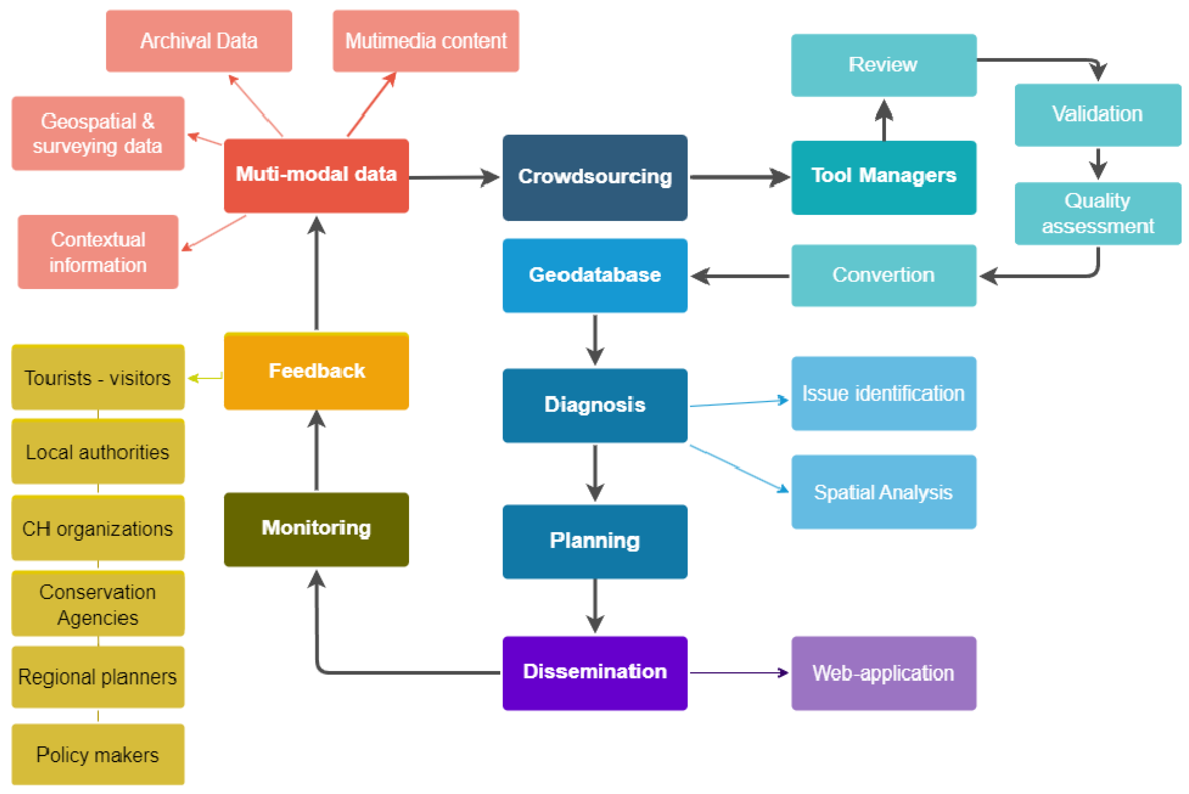
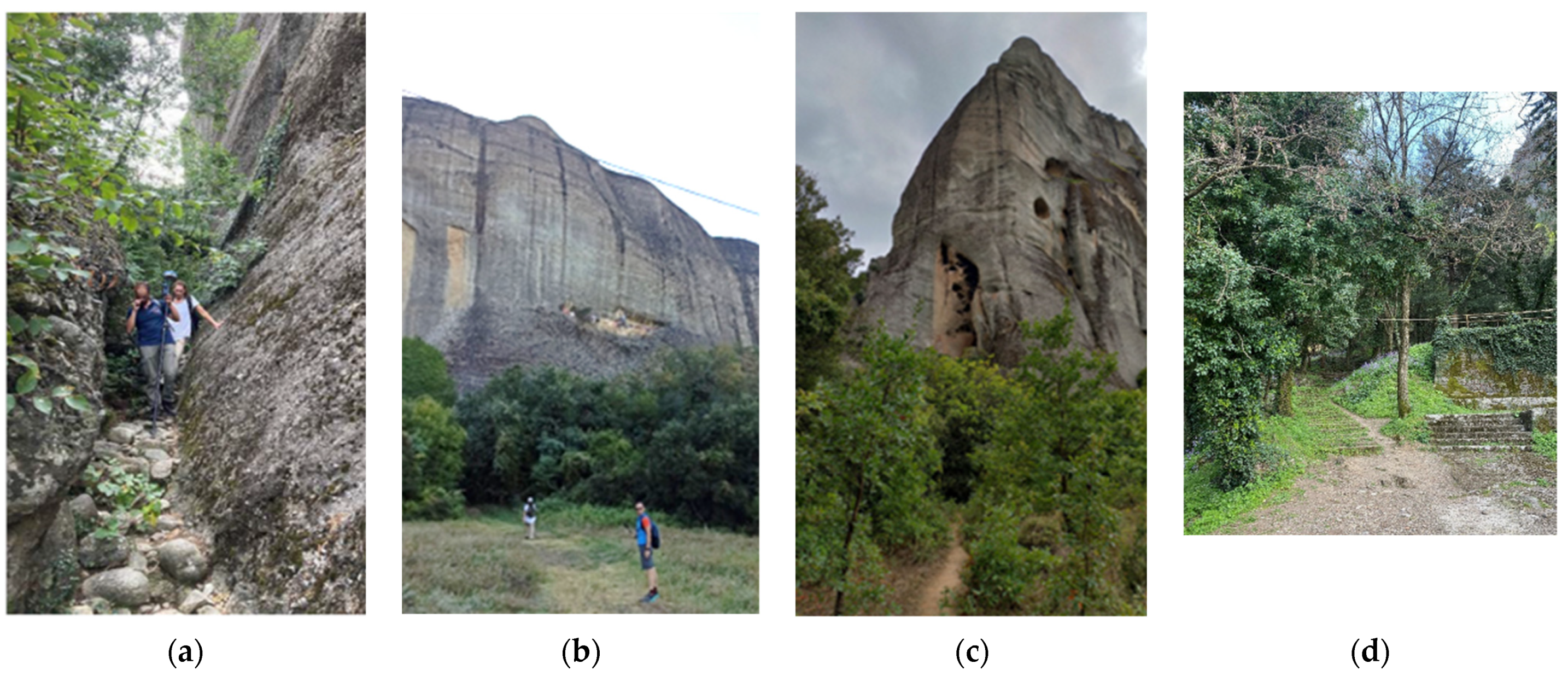
Data from various sources, including geospatial data, crowdsourced information, archival records, expert knowledge, and agency-provided data, are organized and structured within the geodatabase of the tool. The historic trails can be initially recorded with GPS tracking devices and surveying engineering methods. In addition, the current state, real-time and geometrically accurate data collection allows for efficient issue identification and maintenance prioritization. Field surveys and on-site inspections can be conducted to visually identify and document trail issues, such as damaged sections, overgrown vegetation, or missing amenities. Moreover, high-resolution orthophotos or aerial imagery can be used to detect changes in the trail environment. Crowdsourcing involves feedback, issue reports, and multimedia content by visitors, tourists and locals. Heritage organizations contribute archival data, expert knowledge, and conservation information through collaboration with the tool managers, while planners share land-use plans, infrastructure data, and visitor management insights through collaborative workshops, data sharing platforms, or dedicated channels. Local communities share historical and cultural information, personal anecdotes, and traditional practices through community engagement initiatives, workshops, or dedicated portals. The provided content can be images, text documents, video files, metadata, structured data, audio files, etc.
The managers of the tool review and assess the crowdsourced data for accuracy, relevance, and reliability. They validate the data, cross-reference it with existing information, and ensure it aligns with the goals of the geospatial tool and the respective trail network. Feedback loops are established with the data contributors to address any clarifications or follow-up questions. After quality, accuracy and relevance evaluation, the data are converted into compliant-with-GIS file formats, such as shapefile, geojson, Keyhole Markup Language (.kml), CSV (Comma-Separated Values) and DXF (Drawing Exchange Format). The validated crowdsourced data is integrated into the geodatabase of the geospatial tool. Object-oriented GIS-based models and spatial entities are used to incorporate descriptive information, multimedia content, and spatial references. Spatial analysis techniques are employed to diagnose and assess the trail network, as well as to identify issues such as damaged sections, vegetation encroachment, or lack of amenities. Additional geometric information and insights into the trails’ characteristics and challenges can be generated by map algebra operations. Based on diagnosis and analysis, planning activities are conducted to address the identified issues and optimize the trail network. Urban and regional planners can utilize the geospatial tool and its findings to integrate the trails with urban infrastructure, develop land-use plans, and align the trails with sustainable development goals. Conservation measures, infrastructure improvements, and visitor management strategies are planned to enhance the sustainability and visitor experience of the trails. To depict the current state, impact, measurements or potential policies, the geospatial tool utilizes a web application interface to disseminate the developed geodatabase. Users, including tourists, local communities, heritage organizations, environmental agencies, planners, and government authorities, can access the web-app and provide feedback on their experiences, suggestions, or reports on trail conditions. Thus, the managers continuously monitor and evaluate the feedback, updating the geodatabase and the web-app as needed. Feedback loops are established with the data contributors, ensuring a continuous flow of information (
Figure 1).
3.2. Geodatabase Design Principles
Geographic Information Systems (GIS) allow the documentation, organization, management, processing, analysis, visualization and dissemination of geographic information. In this study, a unique geodatabase is designed, developed and enriched with geographic and descriptive information concerning the Holy Site of Meteora. For the implementation of the geodatabase and its final products, the ESRI’s ArcGIS Pro software package is utilized (version 3.0). The information is stored in the form of GIS layers and tables, and can be processed, analyzed and visualized. A variety of tools are provided for the easy search and management of this information, which can be easily selected and used. Not only the simple reading of digital data, but also the compilation of the application results with the appropriate administrative and analytical tools is possible.
All the available geospatial and descriptive data are integrated into a digital geodatabase, whose components can be visualized through the digital map environment of ArcGIS Pro, combined with multiple geographic base-maps providing a comprehensive visualization of the geospatial information. The derived digital map allows the input, storage, and easy retrieval of information related to the trails of the Holy Site of Meteora.
The database structuring process followed the architecture of the three levels (conceptual, logical, physical) that is commonly followed by modern database systems. During the conceptual design of the geodatabase, the following aspects are taken into account:
The study area concerns the archaeological and Holy Site of Meteora, where there is a network of walking trails with a total length of 35 km.
The representation of vector spatial entities is carried out using all forms of geospatial primitives (point, line, polygon).
The calculation of necessary geospatial information (e.g., length of trails, distances between points of interest) is performed by executing map algebra operations.
The visualization of specialized information is achieved through the execution of spatial, descriptive queries or correlations between the property fields (attributes) of the spatial entities.
Continuing with the logical design of the geodatabase, the requirements regarding the type of geodatabase and the relationship between its objects are specified. The logical design is based on the following:
Developing a unique geodatabase based on relational model technology that includes vector spatial entities (feature classes), raster data, and tabular (geodatabase tables) data.
Creating entities with embedded descriptive information. The connection between the spatial and descriptive information is made through an object-oriented data model, according to which the descriptive information is integrated into the corresponding spatial entities in the form of attribute fields.
Selecting the Greek Geodetic Reference System (GGRS87) as the reference system for recording all vector spatial entities.
Creating metadata to interconnect all entities stored in the database.
In the last phase of the physical design, the development of the geodatabase and its enrichment with all the available digital data is conducted, in the environment of ArcGIS Pro. Each spatial entity is stored as a separate thematic layer, allowing for visualization and presentation of geospatial information. Different symbols and labeling are selected for each thematic layer to differentiate spatial entities and visually convey necessary information. By overlaying multiple thematic layers, the possibility of map compilation and implementation of spatial operations and analysis is provided. Thus, the retrieval and study of information regarding the walking trails of the archaeological and Holy Site of Meteora is made available. It also provides the ability to produce embedded 2D maps with built-in tools and supports advanced functionalities, such as:
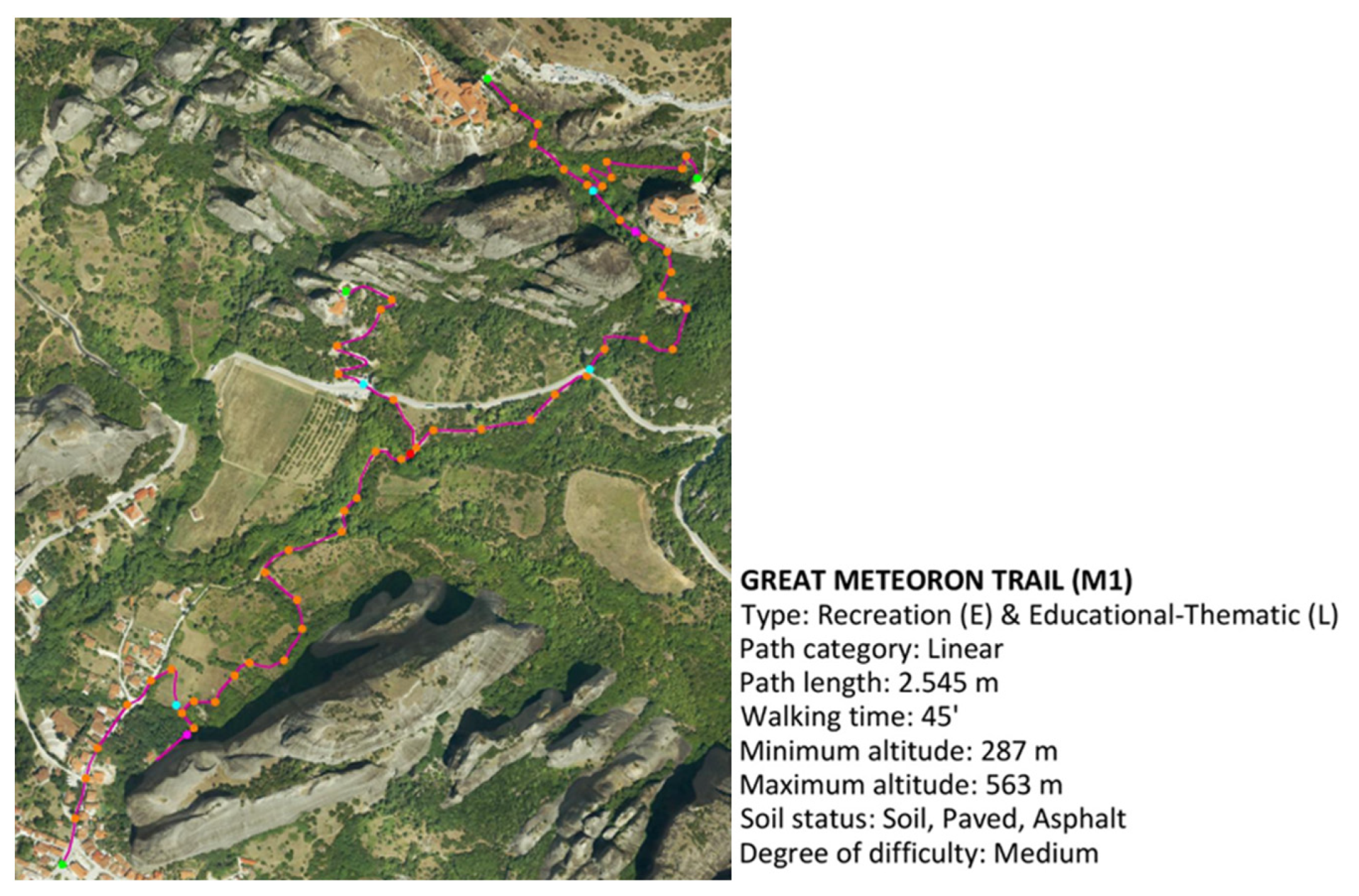
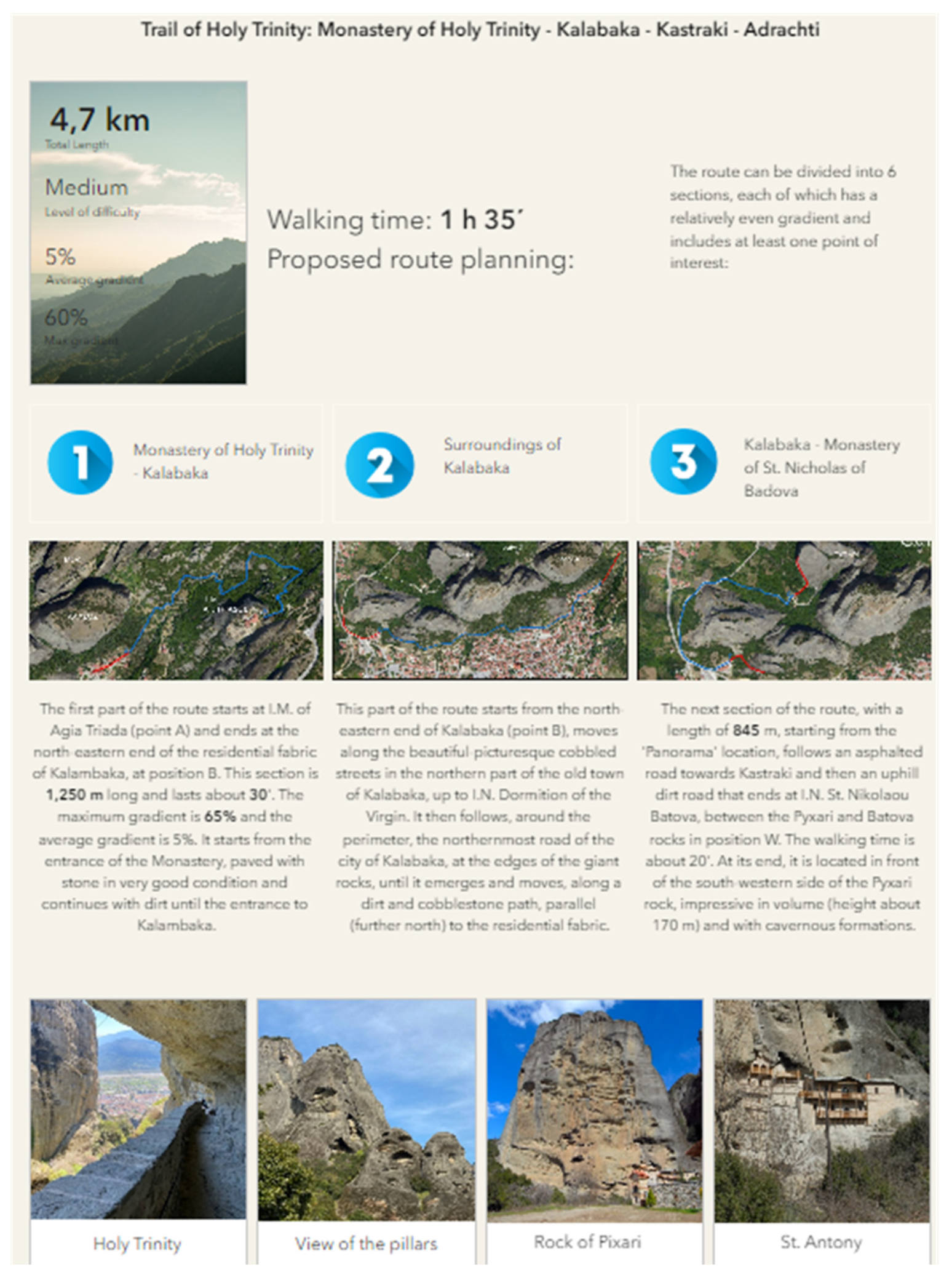
pop-ups that display short pieces of information and images for specific points along the trail;
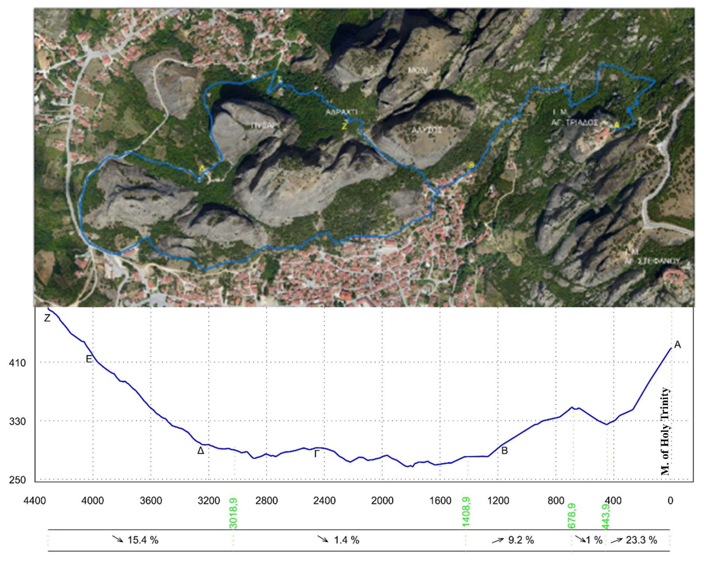
dynamic visualization of the vertical profile of each trail, and;
multimedia information relevant to landmarks, natural features and scenic viewpoints.
3.3. GIS Analysis Techniques
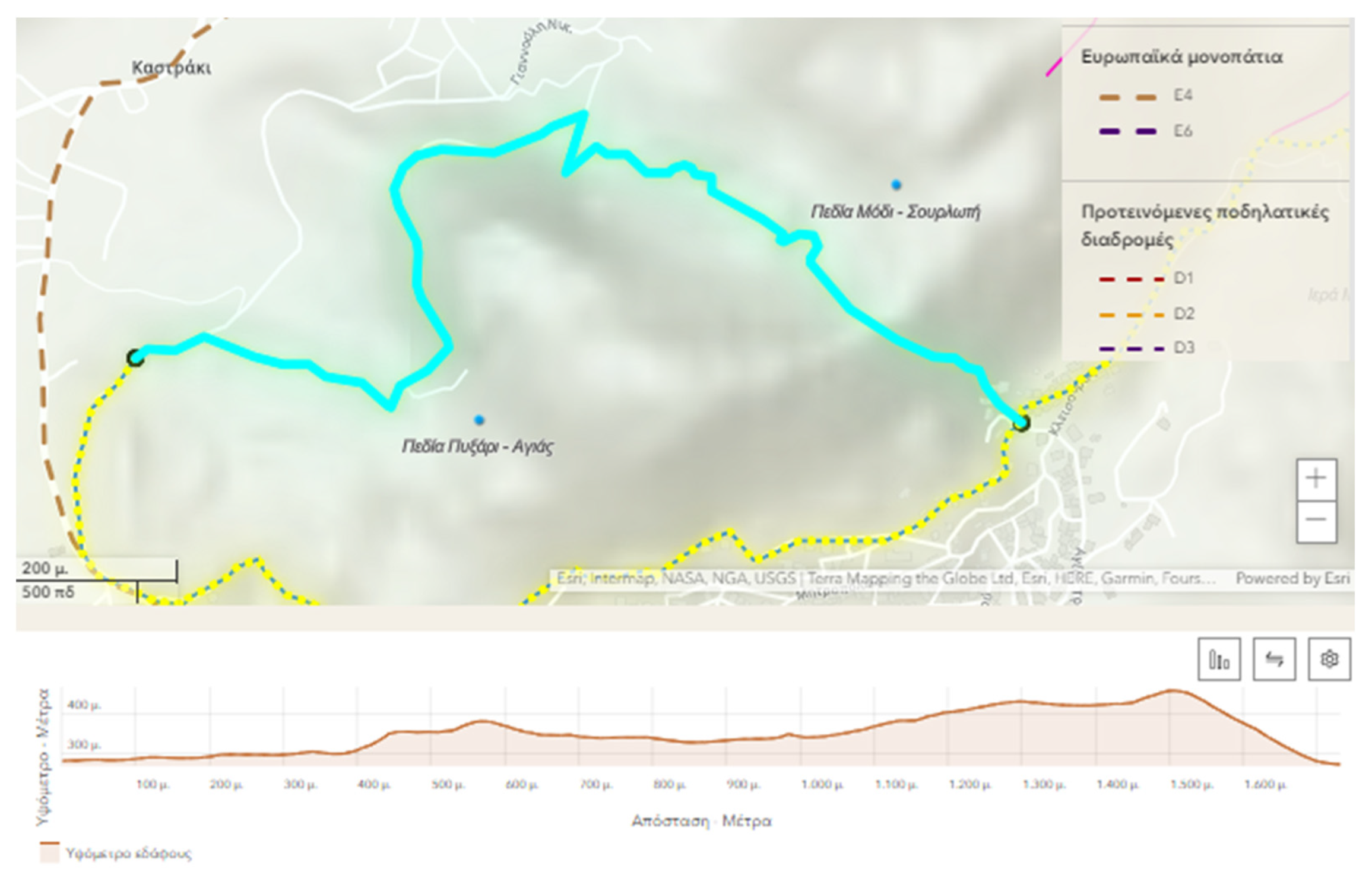
Spatial analysis for historic trails can involve several calculations and tools in the geodatabase in order to manage, diagnose, provide exact information, and finally, plan and depict sustainable policies. In the context of the geospatial tool, several analysis techniques that are tailored to the preservation and maintenance of historic trails are proposed and implemented. Firstly, slope analysis, elevation profiling, and contour analysis assess the terrain and identify challenging sections. Valuable information about the trail’s difficulty, steepness, and changes in elevation can be extracted for visitors and regional planners. Then, viewshed analysis determines the areas visible from specific points along the trail, such as scenic viewpoints, viewpoints of cultural significance, or areas with obstructed views that may require vegetation management. The creation of buffer zones around specific trail features, points of interest or sensitive areas such as cultural heritage sites or environmentally sensitive habitats, helps assess the impact of development and encroachment. Buffer analysis can be combined with hotspot analysis. Hotspot analysis identifies clusters or concentrations of specific trail features or issues. High tourist density, high incidents of damage, or high levels of vegetation encroachment are spatially located and monitored. To enhance the trail network and the combined transport network, analysis tools are integrated into the tool, such as route analysis and connectivity analysis. Route analysis considers trail conditions, terrain, elevation, and visitors’ preferences in order to assess accessibility and provide seamless navigation for visitors. The evaluation of the degree of connectivity within the trail network helps to identify gaps, bottlenecks, or disconnected segments that hinder accessibility or prevent the smooth flow of visitors. By analyzing the connectivity, trail managers can identify areas where additional trails, connectors, or trailhead facilities may be needed to improve accessibility and promote sustainable use of the trail network. Sustainable trail networks may require integration with other modes of transportation, such as public transport or cycling routes, to access and distribute visitor traffic more evenly. The tool supports the determination of the best combination of transportation modes based on the existing transport infrastructure and by taking into consideration factors such as proximity to public transport, parking availability, and barrier-free access for individuals with disabilities. Further utilities of the tool concern spatial interpolation and land use analysis. Techniques, such as kriging or inverse distance weighting, estimate values at unsampled locations based on known data points. For example, if data on trail surface conditions (e.g., smoothness, roughness) or trail erosion levels are available at certain locations along the trail, these techniques can be employed to predict the conditions at other locations where data may be lacking. This information can help policy makers, local authorities and environmental agencies to assess maintenance needs, prioritize interventions, and allocate resources effectively to ensure safe and enjoyable trail experiences for visitors. Finally, analyzing land use patterns and overlaying them onto the trail network enable the recording of potential conflicts, zoning issues, or areas where land use changes may impact the historic trail.
3.4. Online Dissemination
Planning, decision making, regulatory and standards development and knowledge transfer are mandatory, but inefficient if they are not accessible, visually perceived and participatory. Once published on the web, the geodatabase bridges the gap between stakeholders involved in CH management. Its visualization can be used as a cartographic basis to link geopolitical, economic and social operations with their spatial reference for a wide range of scientific specialties. The general public can explore the linked open data, plan their visit, walking and recreation activities and share any route or related information they are interested in on social media.
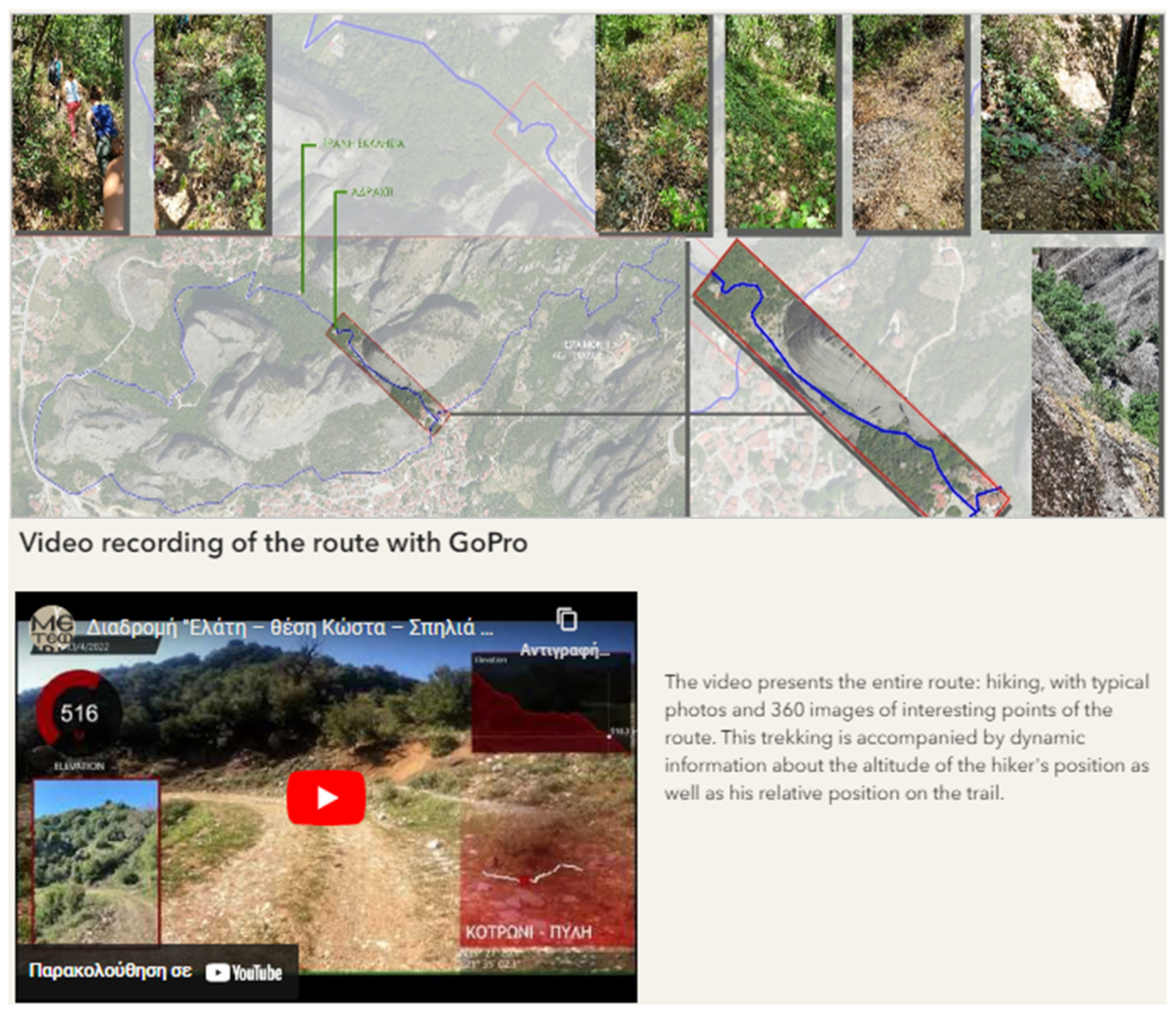
The integrated dataset comprises the proposed trail network, related multimedia files, exact location data and information regarding land cover, transport links, local touristic businesses, descriptions and statistics, as well as general information and level of heritage attractiveness. Images are pre-processed before being published on the web to ensure a qualitative consistent and uniform display across all devices. The selected JPEG quality ranges from 95–98% to maintain the original resolution. Finally, they are converted to the sRGB color space. Video files need to be already online in a social media platform such as YouTube. The URL of the uploaded video is used to embed it and show it to the framework via the built-in front-end media player. The data are stored in the ArcGIS Online software cloud for global access to the maps, both by members and non-members of the ArcGIS community. The application is implemented on top of ArcGIS Web AppBuilder software [
28] and the Leaflet.js library [
29]. Leaflet.js is an open-source client-side JavaScript library for creating online maps and services with interactive, responsive and mobile-friendly design. The Esri Leaflet open-source software development package is used to access ArcGIS location services and extend or customize the built-in functionalities of ArcGIS Web AppBuilder. Emphasis is given to the interaction of the application with the user through (i) sophisticated map navigation and real-time information retrieval mechanisms, and (ii) multiple levels of logical/semantic search depth and specialization.
The web application enables the depiction of measures for sustainable management and eco-tourism, addressing key aspects such as awareness raising and promotion of lesser-known monuments along the network. By highlighting these sites, the application can distribute visitor flows more evenly and reduce overcrowding at popular locations. It also addresses the redistribution of visitor flows by providing information on alternative routes and off-peak times, promoting a balanced visitor experience. Additionally, sustainable means of transportation and touristic activities throughout the site are introduced, encouraging eco-friendly travel options and minimizing environmental impacts. Lastly, it fosters active collaboration between policy makers and cultural heritage authorities, facilitating dialogue and informed decision-making to ensure the preservation and sustainable development of historic trails.
5. Discussion
The developed geospatial tool provides valid knowledge for sustainable mobility and alternative touristic activities. The proposed integrated network introduces sustainable means of transportation throughout the broader region. It enhances awareness raising, promotion of lesser-known areas and points of interest of the region, and redistribution of visitor flows. The decision making process can be achieved through the proposed GIS-based analysis method and the Master Plan for walking routes can be used as guidance for trail management and operational planning. The proposed tool links geopolitical, economic and social operations with their spatial reference on a cartographic basis. Thus, it makes the strategy for sustainable development more precise and forward-looking, allowing for planning, maintenance and promotion. The easy-to-use and interactive services make the online GIS-based application a means of understanding basic knowledge and providing meaningful contact with the space and its historical and cultural context. It can also depict sets of measures and addresses the following actions:
awareness raising and promotion of lesser-known monuments along the network;
redistribution of visitor flows and transport accessibility;
introduction of sustainable means of transportation;
active collaboration between policy-makers.
Unlike the Nakahechi Heritage Route analysis [
17] and Georoutes in Santa Elena province [
21], the presented work integrates various types of data source (topographic surveying, photographic documentation, walking tour video recording, and archival research) to create a more comprehensive and heterogeneous dataset. It covers multiple factors and incorporates both on-foot and bicycle metrics, making it more versatile for tourist-centric historic sites with different transportation modes. Similar to the GIS-based Atlas of Roman Routes in the Danube Region [
26], the geospatial tool provides an online solution for dissemination, remote access, and collaboration purposes, making it accessible to a wider audience. By providing valid knowledge for sustainable mobility and alternative touristic activities, the tool helps promote sustainable tourism practices and alleviate the burden on fragile ecosystems or culturally significant sites. It enables the identification and mapping of damaged sections of trails, overgrown vegetation, and other issues, which allows for specific interventions to improve the trail’s condition and minimize environmental impacts.
The feedback obtained through crowdsourcing plays a vital role in improving the geospatial tool, refining the data integration process, enhancing trail planning and management, and addressing any concerns or issues identified by the users. It helps create a continuous feedback loop where the tool managers assess the input data, make necessary updates or improvements, and then provide feedback to the groups involved in the crowdsourcing process. The managers play a crucial role in maintaining the integrity of the tool and making informed decisions regarding data selection and utilization. Each of the following target audience could benefit from utilizing this tool:
Tourists and Visitors: Tourists and visitors interested in exploring and experiencing historic trails can utilize the web-based platform of the tool to plan their itineraries, learn about points of interest, view multimedia content, and gain insights into the historical and cultural significance of the trail network. The interactive maps and 3D visualizations enhance the visitor experience and enable them to make informed decisions about their trail exploration.
Local Communities: The tool can be valuable for local communities residing near the historic trails. It can engage local community members by involving them in data collection, contributing to the geodatabase, and providing input on the maintenance and development of the trails. It also facilitates sustainable community-based tourism initiatives, leading to economic benefits for the local population.
Heritage Organizations: Organizations dedicated to the preservation and promotion of cultural heritage can exploit the tool to manage and safeguard historic trails effectively. It assists in identifying conservation needs, prioritizing maintenance activities, ensuring the preservation of heritage assets and supporting educational initiatives.
Environmental and Conservation Agencies: Environmental and conservation agencies can benefit from the tool’s capabilities in identifying issues along the trails, such as damaged sections or ecological threats. They can use the geospatial information to assess the impact of trail usage on the environment, monitor biodiversity, and plan conservation measures and sustainable management practices, ensuring the balance between heritage preservation and ecological conservation.
Urban and Regional Planners: Urban and regional planners involved in the development and management of sustainable cities and communities can utilize the tool to incorporate historic trails into their planning processes and embrace cultural heritage as a vital component. The geospatial tool provides valuable information for decision-making regarding the integration of trails with urban infrastructure, land-use planning, and tourism development.
Government Authorities and Policy Makers: Government authorities responsible for heritage preservation, tourism development, and regional planning can make informed policy decisions and attain sustainable development goals, such as those outlined in the UN Sustainable Development Agenda 2030. The comprehensive data and analysis offered by the tool facilitate evidence-based planning, identification of priorities, and allocation of resources.
6. Conclusions
The paper provides necessary technical, legal, historic and administrative information related to the developed tool and its use. The heterogenous dataset derives from topographic surveying, photographic documentation, walking tour video recording and extensive archival research. The GIS reference points trace the historic routes. A unique geodatabase, which is based on relational model technology and includes vector spatial entities, mosaics and tabulated data, is developed within the ArcGIS Pro environment. The connection between spatial and descriptive information is achieved through an object-oriented data model, according to which descriptive information is integrated into the corresponding spatial entities in the form of attribute fields. The calculation of the necessary geometric information (e.g., length of paths, distances of points of interest) is conducted by performing map algebra operations, alongside the visualization of specialized information by spatial, descriptive queries or correlations between attribute fields of spatial entities. Damaged sections of trails, overgrown vegetation, signage and wayfinding markers, as well as lack of handrails, seating or rest areas along the trail, have been also, detected, spatially identified, analyzed and mapped in order to form specific interventions. Finally, the developed geodatabase, enriched with multimedia information relevant to landmarks, natural features, scenic viewpoints or other points of interest, is disseminated in the context of ArcGIS online. The web application embeds 2D maps with built-in features, such as bookmarks, measurement tools and search bars. Interactive elements include (i) pop-ups that display short information and images about specific points or features along the trail and (ii) dynamic visualization of the vertical profile of each trail, namely the 3D representation of its elevation, including the high points, low points, and changes in slope.


 ,
, 


