Article

The In-Situ Spatial-Temporal Evolution of the Settlement Space along the Grand Canal Tianjin Section from the Perspective of Cultural Heritage

1
School of Architecture, Tianjin Ren’ai College, Tianjin 301636, China
2
School of Architecture, Tianjin University, Tianjin 300072, China
3
School of Landscape Architecture, Beijing Forestry University, Beijing 100083, China
*
Author to whom correspondence should be addressed.
Land 2023, 12(5), 1023; https://doi.org/10.3390/land12051023
Submission received: 14 March 2023 / Revised: 3 May 2023 / Accepted: 4 May 2023 / Published: 6 May 2023

Abstract

:
The Grand Canal of China, as a traffic artery in ancient China, has exerted profound influence on the development of the cities, towns and rural settlements along it. Now, with China’s rapid urbanization, numerous settlements along the canal are confronted with problems like slow cognition of the cultural heritage, loss of the local culture and damage of historical relics. Hence, research on the protection and updating of the settlement space along the canal is in urgent need. This paper, targeting the settlement space along the Grand Canal Tianjin Section, adopts such research methods as the Historical GIS analytical method, the kernel density estimation method and the average nearest-neighbor method to quantitatively analyze the evolution stage and distribution characteristics of the settlement space along the Grand Canal Tianjin Section from the perspective of cultural relics to reveal the in-situ rules of evolution of the settlement space. The research result indicates that the spatial-temporal evolution of the settlement space can be divided into five such periods of the settlements along the canal as the pre-canal period, the rudimentary period, the development period, the mature period and the transformation period. Each period features different cultural relics and settlement distribution patterns. The research shows that the natural geographical environment, the grain transportation projects and management systems, the wasteland opening, grain growing and military defense policies, the agricultural, commercial and economic growth and the migration and folk culture are the influencing factors of the spatial evolution of the settlement space along the Grand Canal Tianjin Section.

1. Introduction

The Grand Canal of China totally stretching up to 3200 km boasts a long history of more than 2500 years. A great engineering project in ancient China, it is also the longest and largest canal in the world [1,2]. At present, the area along the canal abounds with cultural resources, including 8 provinces and municipalities, 27 cities, 19 world cultural heritage sites, 1606 national key cultural relics protection units, 277 famous historic and cultural cities, towns and villages and 2190 museums. The ancient Chinese lived near the river, and the natural rivers provided both a plentiful source of water and convenience for people’s traveling and migration. The cities, towns and villages, once important nodes of the Grand Canal of China in history, changed with the vicissitudes of the canal [3,4]. Now, they have developed to be unique canal culture scenes and boast significant value of conservation and inheritance [5,6].
Towns and villages densely dot the area along the Grand Canal Tianjin Section. However, the Tianjin Canal Cultural Heritage Area only has one national famous historic and cultural town, one city-level famous historic and cultural town and one city-level famous historic and cultural village, and there are still a huge number of settlements along the canal not included in the scope of conservation. With the surging development of China’s urbanization, numerous settlements along the canal still suffer such problems such as low cognition of the cultural relics, loss of the local culture and damage of historical heritage [7,8]. To innovatively salvage the fragile settlements along the canal, it is urgent to systematically classify the in-situ spatial-temporal evolution characteristics of the settlement space along the canal, analyze the evolution rules and stimulate its conservation, utilization, inheritance and development.
The UNESCO’s Convention Concerning the Protection of the World Cultural and Natural Heritage [9] and Operational Guidelines for the Implementation of the World Heritage Convention [10] are the basis and fundamental documents to world cultural heritage site declaration, evaluation and management. In 1994, with the support of Parks Canada Heritage, related experts submitted “The information Document on Heritage Canals” to the World Heritage Committee that issued the List of Historical Sites of International Canals [11]. In 2005, UNESCO nominated heritage canals and cultural routes as the new world cultural heritage. In June of 2014, the Grand Canal of China was nominated into the World Cultural Heritage List. The settlements along canals, as a type of local architecture heritage, are also world cultural heritage resources. In 2021, in an initiative of the Sustainable Development Goals Working Group of ICOMOS, an important role of the heritage has been clarified that heritage—natural and cultural, tangible and intangible—is fundamental to addressing the United Nations (UN) Sustainable Development Goals (SDGs) [12]. Further, the Sustainable Development Goals Working Group is developing solutions on how water, heritage and sustainable development intersect [13].
The research of the international community on the settlements along canals chiefly focuses on the canal irrigation system and the settlements, the settlements along the canals, the canal city environment management and public participation and land use changes [14]. The current research on the settlements along canals has entered a fast lane, with the content involving tourism development, landscape evolution, local perceptions, spatial patterns, cultural landscape and ecological cities. Conzen M.P. brought forth the heritage area theory on heritage corridors along the canals to develop the regional economy [15]; Garcia-Mayor C. researched the evolution of the traditional landscape around the Segura in Alicante [16]; Lavoie C. set up the theoretical framework of the “environment of memory” in the Logan Canal settlements to explain how to find the significance of landscape spanning time and culture [17]; Biscaya S. et al. researched the possibilities of developing the smart ecological city corridors along the Manchester Canal [18]. Flemsæter. F adopted the Rhythm Analysis Approach to discuss the development potentials of rural tourism along canals [19].
In recent years, a lot of scholars have researched the settlement space along the Grand Canal and have attained some achievements. The first is to macroscopically analyze the management, spatial characteristics and evolution rules of the land along the Grand Canal. Jintao Li et al. analyzed the spatial-temporal changes of land urbanization and the social and economic benefits of the 21 cities along the canal and discussed the man-land effector mechanism [20]. Feng Tang et al. made quantitative research on the relationship of the urbanization and habitat quality of the 35 cities along the canal [21]. Wang Feng et al. researched the spatial characteristics and evolution rules of land and water transportation space of the cities along the canal since the middle and later periods of the Qing Dynasty [22]. The second is that the research objects are chiefly the settlements neighboring on both banks of the canal, and the content is to extract the characteristics of the spatial forms of the settlement space along the canal or interpret the cases of the typical settlements along the canal. Qingwen Rong et al. interpreted the cultural relics along the Grand Canal Hangzhou Section and discussed the correlation between historical events and canal’s value [23]. Xin Jin et al. researched the linear urban landscape and spatial pattern of the Grand Canal Hangzhou Proper Section [24]. Xiaolong Huo et al. researched the spatial form and distribution characteristics of the rural settlements along the Grand Canal Shandong Section [7]. The present paper applies the structural equation model to analyze the current living situation of the space environment along the Grand Canal Tianjin Section [25], the in-situ phenotype of the 18 typical settlements along the Grand Canal Tianjin Section and the in-situ genes and rules of the settlement space there [26].
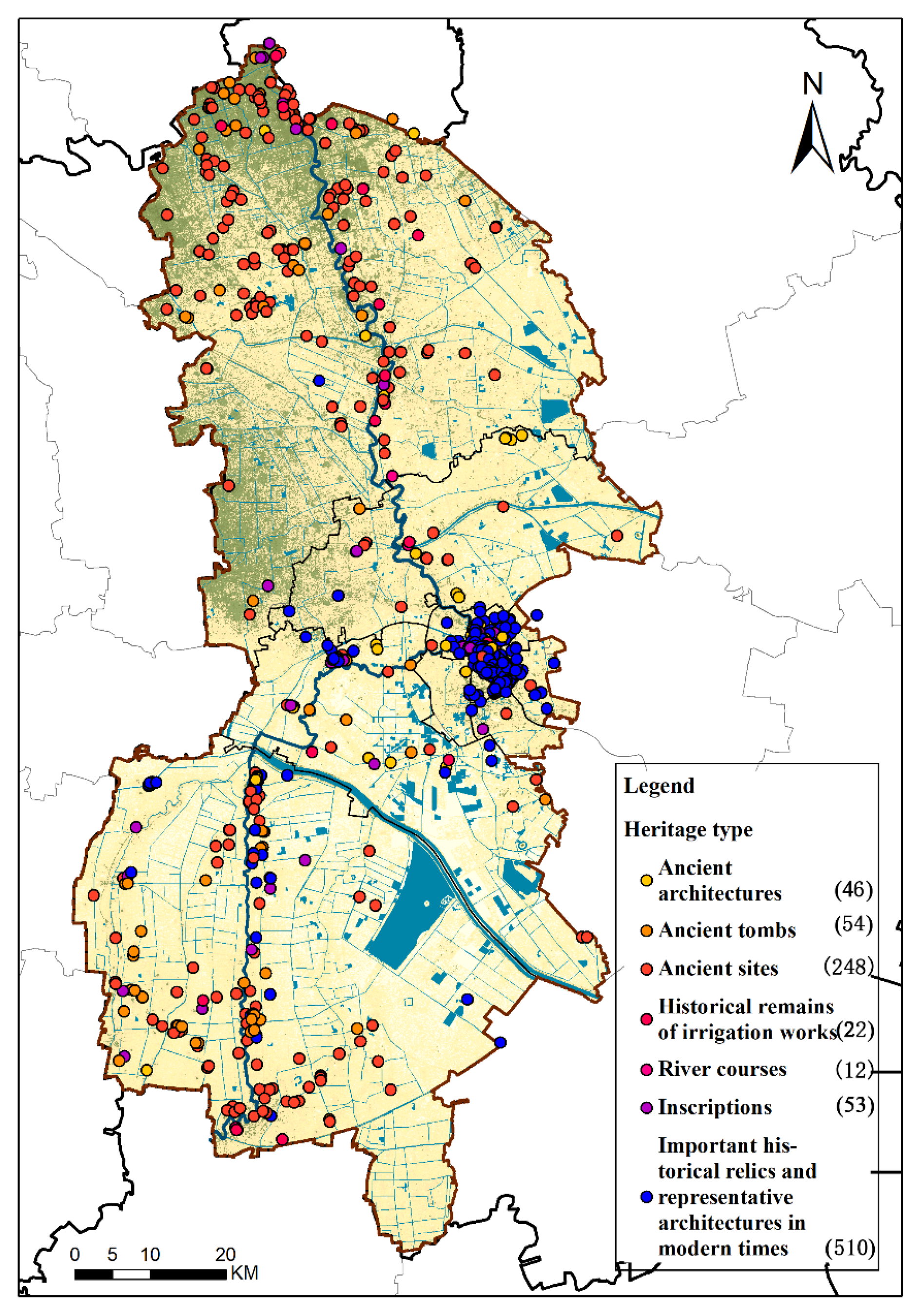
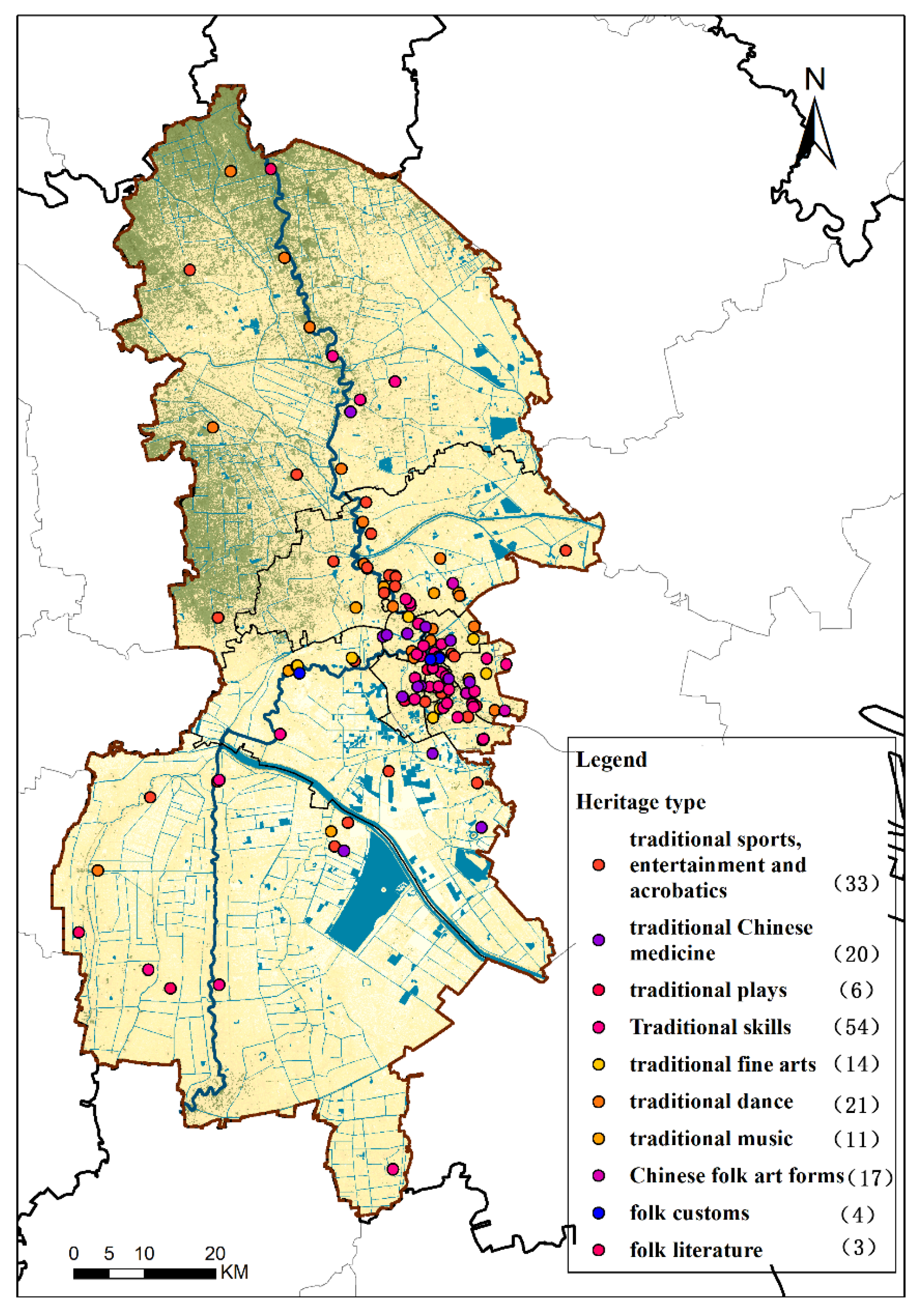
Nonetheless, the previous research on the settlements along the canal had some limitations, focused on macroscopic analysis of the cities along the canal, extracted the morphological characteristics of the settlement space along the canal and interpreted the cases of typical settlements along the canal. The in-situ phenotype of different settlement space along the canal is different, and the spatial-temporal evolution characteristics and rules of the settlement space in different cities and towns along the canal should be classified holistically. The paper takes the settlement space along the Grand Canal Tianjin Section as the research object, analyzes the in-situ evolution periods of the settlement space along the Grand Canal Tianjin Section, quantitatively interprets the distribution characteristics of the cultural relics and settlement space along the canal such as ancient architectures, ancient tombs, ancient sites, historical remains of irrigation works, inscriptions and intangible cultural heritage sites and brings forth the in-situ diachronic evolution rules of the settlement space along the Grand Canal Tianjin Section.

2. Data Sources and Research Methods

2.1. Overview

Seated between 38°34′ and 40°15′ in the northern latitude and between 116°43′ and 118°4′ in the east longitude, on the northeast of the North China Plain, at the lower reaches of the Haihe River Basin, bordering on the Bohai River in the east, Yanshan Mountain in the north and Beijing in the west, Tianjin is a central city of China, the largest harbor city in the north, a strategic fulcrum of the Maritime Silk Road and the intersection of the “Belt and Road”. The survey region includes the South Canal and the North Canal at the Grand Canal Tianjin Section, stretches totally up to 195.5 km and runs through seven districts in Tianjin, namely, Wuqing District, Beichen District, Hebei District, Hongqiao District, Nankai District, Xiqing District and Jinghai District, where city, town and rural settlements densely dot (Figure 1).

2.2. Data Sources

Basic data sources primarily include data of historical maps, vectors and raster and cultural relics of Tianjin (Table 1). The data of historical maps refer to the historical maps and special cultural relics maps of Tianjin included in Chinese Cultural Relics Atlas edited by the National Cultural Heritage Administration and the Tianjin City History Atlas edited by Tianjin Municipal Bureau of Planning and Natural Resources. The data of vectors and raster are sourced from the data of the administrative villages along the Grand Canal Tianjin Section, the ALOS 12.5 m DEM data, the urban river system and traffic acquired from the Resource and Environment Science and Data Center of the Chinese Academy of Sciences (CAS). In different periods, the settlement data were sourced from the local chronicles and various historical records. The cultural relics data are sourced from the relics data of the Grand Canal Tianjin Section released in the Specifications on National Land Management in the Core Monitoring Zone of the Grand Canal Tianjin Section, the data of the cultural protection units at all levels and the immovable cultural heritage data provided by the cultural and tourist administrations in the districts of Tianjin and the data of the national level and Tianjin level intangible cultural heritage provided by the intangible cultural heritage website of Tianjin.

2.3. Research Methods

2.3.1. Selection of the Research Methods

(1)
The Historical GIS Analytical Method
The historical geographic information system is briefly called HGIS (Historical GIS). It is a new field to research historical questions by applying the GIS technology invented in the mid-1990s. Through the GIS acquisition, storage, management and analyzing technologies, it can effectively boost the spatial analytical ability and application level of historical geography and cultural geography [27]. The main advantage of HGIS is to provide the new method of historical resources management, the space visualization model and the new methodology of spatial analysis [28]. The rising amount of paper on historical geography based on GIS also reflects the value and prospects of HGIS [29,30,31,32,33]. Xi Xuesong et al. applied HGIS to research the ingate hub of the Grand Canal Huai’an Section in Jiangdu and reveal the evolution rules of the historical heritage of the canal [34].
(2)
The Kernel Density Estimation Method
The kernel density estimation method can directly reflect the agglomeration degree of the cultural relics along the Grand Canal Tianjin Section, detect the local density changes of the cultural relics of the canal and express the kernel density visualization space distribution model in the computational formula:
f ( x ) = 1 n h i = 1 n k ( x x i h )
In it, f ( x ) is the kernel density value; h is the radius of search; n is the number of the given points within the radius of search, namely, the number of sampling points; k is the kernel function; x x i is the distance from point x to sample x i . The detection and analysis of various radius of search show that, when the radius of search is 8 km, the whole spatial distribution characteristics of the elements tend to be obvious, and when the radius of search is bigger than 8 km, the analytical result is excessively comprehensive. Hence, the nearest radius of search is set to be 8 km.
(3)
The Average Nearest-neighbor Index Method
The average nearest-neighbor index method can objectively and accurately reflect the geographical space distribution characteristics of the settlements and cultural relics along the Grand Canal Tianjin Section. The average nearest-neighbor rate can be obtained by the observed average distance divided by the expected average distance in the following formula:
A N N = D ¯ o D ¯ e
In it, D ¯ o is the average distance observed between each element and its nearest neighbor;
D ¯ o = i = 1 n d i n
D ¯ e indicates the expected average distance of designated elements in the random model;
D ¯ e = 0.5 n / A
If the index (the average nearest-neighbor rate) is lower than 1, the model is a cluster. If the index is higher than 1, the model tends to disperse.
(4)
The Standard Deviational Ellipse Analytical Method
The standard deviational ellipse analytical method creates a standard deviational ellipse to summarize the spatial characteristics, centralized tendency, dispersion and direction tendency of the settlements and cultural relics of the canal. The tool of the standard deviational ellipse creates a new output characteristic including elliptical polygons. The attribute value of these elliptical polygons includes an X coordinate and Y coordinate in the average center, two standard distances (long axis and short axis) and the directions of the ellipses. The computational formula of standard deviational ellipse is:
S D E x = i = 0 n ( x i X ¯ ) 2 n
S D E y = i = 0 n ( y i Y ¯ ) 2 n
In it, x and y are the coordinates of characteristic i; { X , ¯   Y ¯ } represents the center of the mean value of the characteristics; and n indicates the total of the characteristics. The computational formulas of the rotation angle are
tan θ = A + B C
A = ( i = 0 n x ˜ i 2 i = 0 n y ˜ i 2 )
B = ( i = 0 n x ˜ i 2 i = 0 n y ˜ i 2 ) + 4 ( i = 0 n x ˜ i y ˜ i ) 2
C = 2 i = 0 n x ˜ i y ˜ i
Among them, x ˜ i   and   y ˜ i represent the deviations of x coordinate and y coordinate from the average center. The standard deviation values of x axis and y axis are
σ x = 2 i = 0 n ( x ˜ i cos θ y ˜ i sin θ ) 2 n
σ y = 2 i = 0 n ( x ˜ i sin θ + y ˜ i cos θ ) 2 n
(5)
The Average Center Analytical Method
The average center refers to the average x coordinate and y coordinate of all the elements in the survey region. The average center analytical method can help analyze the core and migration rules of spatial distribution of the settlements and cultural relics along the canal in different periods.
The average center can be expressed as follows:
X ¯ = i = 1 n x i n ,   Y ¯ = i = 1 n y i n
In it, x i and y i indicate the coordinates of element i , and n is the total of the elements.

2.3.2. Formation of the Research Thinking

The research thinking of the in-situ spatial-temporal evolution of the settlement space along the Grand Canal Tianjin Section is shown in Figure 2.
The first step is the stage of historical map and data collection which can be divided into the positioning of the historical scenarios and the collection of the data of the cultural relics and the settlements in the survey region in ancient Tianjin. The positioning of the historical scenarios of ancient Tianjin chiefly includes collection and classification of the historical maps of the ancient river courses, canal system, ancient shoreline and ancient county borders of Tianjin in different historical periods. It further specifies the historical periods of the settlement space along the Grand Canal Tianjin Section by referring to such literature as the ancient history of Tianjin, the architectural history of Tianjin, the ancient history of urban development of Tianjin, Tianjin City History Atlas and Chinese Cultural Relics Atlas and by consulting the experts on the architectural history and cultural history. The collection of the data on the cultural relics along the Grand Canal Tianjin Section includes collecting the data on the tangible and intangible cultural heritage sites and the settlements in different historical periods by referring to the literature and website of the government and by consulting with related experts. Related research has been done in the literature review method, the expert consultation method and the EXCEL statistical method.
The second step is the stage of collecting digital historical maps which is divided into classification and digitization of historical geographical information and information survey and integration. The classification and digitization of historical geographical information primarily includes adopting GISMAP to draw the maps of the water system of the Grand Canal Tianjin Section in different historical periods by historical map analysis and literature classification and applying GISMAP to establish the database of the cultural relics and settlements along the Grand Canal Tianjin Section by means of data classification, literature quantity and field survey of the cultural relics and settlements in the survey region (Figure A1, Figure A2 and Figure A3).
The third step is the stage of spatial-temporal evolution analysis which can be divided into the stages to analyze the spatial-temporal evolution and distribution characteristics of the settlement space and the in-situ spatial-temporal evolution rules of the settlement space along the Grand Canal Tianjin Section. GISMAP has been applied to draw the maps of the changes of the Grand Canal Tianjin Section and the distribution of the cultural relics and settlements along the canal in different periods. The HGIS analytical method, the kernel density estimation method and the average nearest-neighbor index method can profoundly analyze the evolution characteristics of the cultural relics and settlements [25].
The fourth step is the stage of analyzing the in-situ spatial-temporal evolution rules of the settlement space along the Grand Canal Tianjin Section. The statistical analytical method, the standard deviational ellipse analytical method and the average center analytical method were applied to comparatively analyze the evolution and its influencing factors in a bid to clarify the evolution rules.

3. Evolution Stages and Distribution Characteristics of the Settlement Space along the Grand Canal Tianjin Section

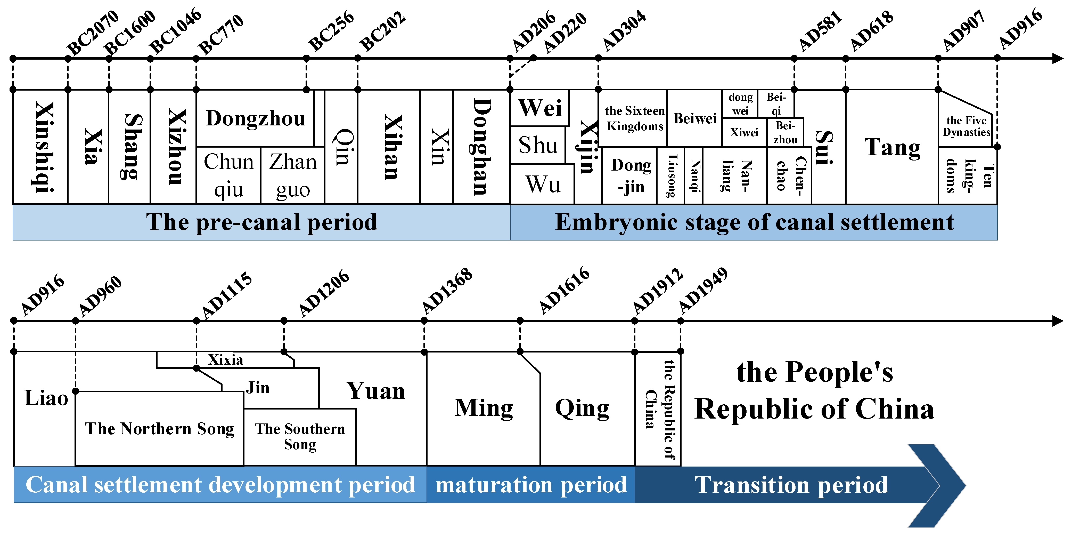
According to the digging history of the canal and the history of urban development of Tianjin, the spatial-temporal evolution of the settlement space along the Grand Canal Tianjin Section can be divided into such five periods of the settlement space along the canal as the pre-canal period (from the primitive society to the Han Dynasty 8000BC–220AD), the rudimentary period (the Wei Dynasty, the Sui and Tang Dynasties and the Five Dynasties and Ten Kingdoms period 220AD–916AD), the development period (the Song, Liao, Jin and Yuan Dynasties 916AD–1368AD), the mature period of settlements along the canal (the Ming and Qing Dynasties 1368AD–1912AD) and the transformation period (the Republic of China 1912AD–present) (Figure 3). GIS was applied to draw the maps of different historical periods and the cultural relics to further demonstrate the evolution characteristics of the settlement space along the canal.

3.1. The Pre-Canal Period: From Primitive Society to the Han Dynasty (8000BC–220AD)

The paper summarizes the pre-canal period into the Neolithic Period (about 5000BC), the Xia, Shang and Zhou Dynasties (2070BC–256BC), the Warring States Period (475BC–221BC) and the Han Dynasty (202BC–220AD).

3.1.1. Early Geographical Environment

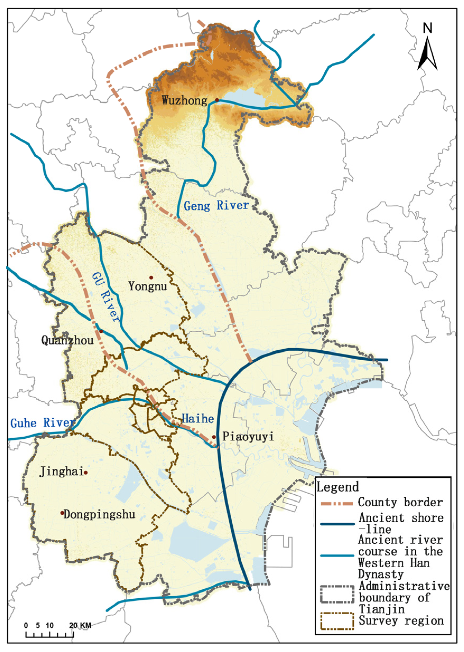
The plain where Tianjin is located was formed below the sea level of the transgression in the recent epoch. In a low-lying terrain, most parts of the area stay at an altitude below 5 m, and the coastal area stays below 3 m, hence vulnerable to the influence of fluctuations of the sea level. The rivers originated at the western and northern sides of Taihang Mountain and Yanshan Mountain and flow into the sea, making Tianjin one of the area’s most densely dotted with rivers. In the period of universal warming of the new epoch 5000–8000 years ago, the Tianjin Plain encountered transgression, and the development of ancient culture was forced to come to an untimely end. It was not until the second transgression in Tianjin in the Han Dynasty that the dense settlements in the Warring States period were all destroyed (Figure 4). The Haihe river system was formed in the late Eastern Han Dynasty, facilitating the digging of the Grand Canal Tianjin Section and the development of the settlements in Tianjin [24].

3.1.2. Cultural Relics Distribution Characteristics

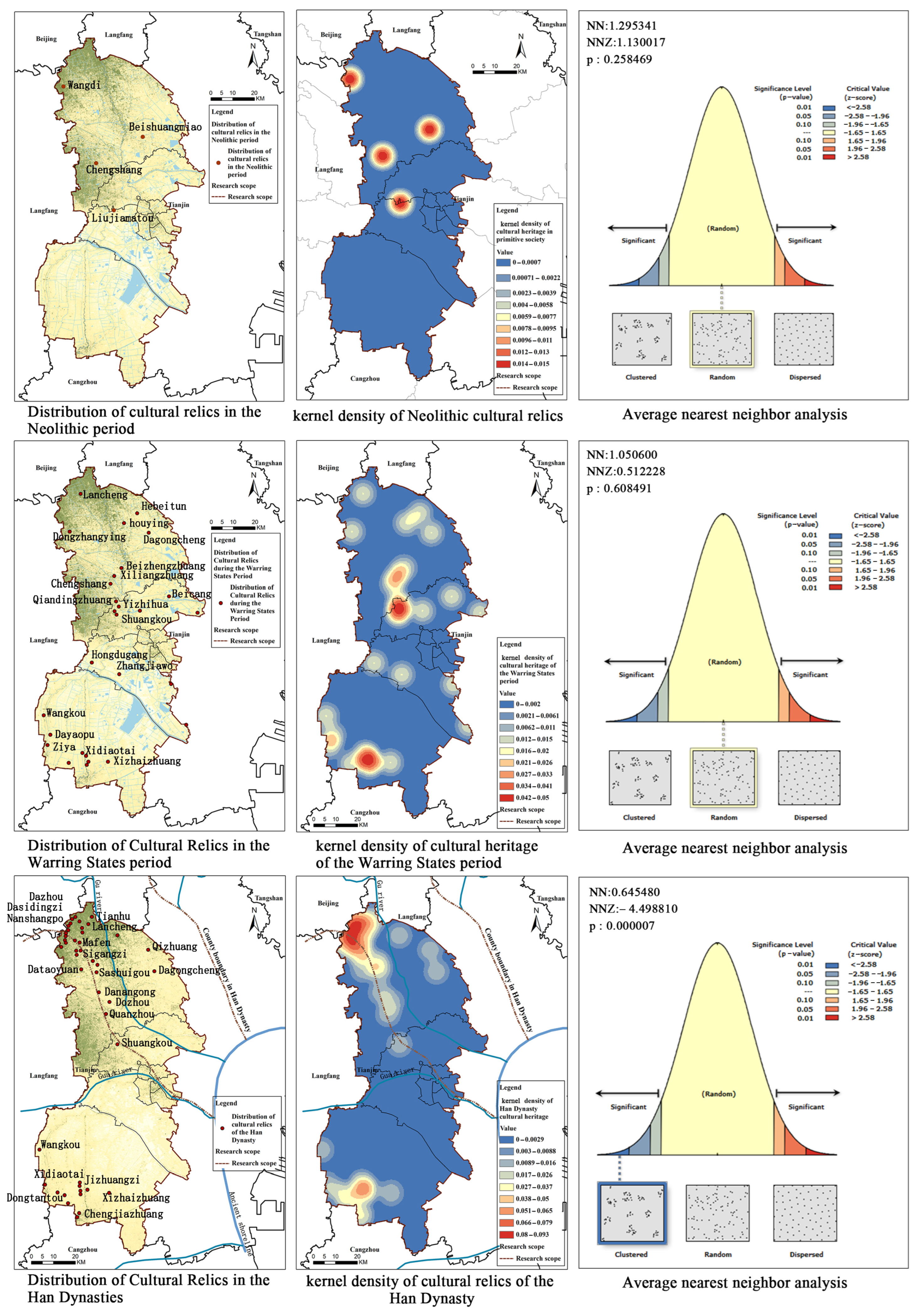
There is no written record about Tianjin in ancient times, and the development of settlements can only be proved by the cultural relics [35]. There are merely four remaining settlements in the survey region [36]. The kernel density analysis of the cultural relics indicates (Figure 5) that the high-value primitive settlements are mainly distributed in Wangdi Village, Beishuangmiao Village and Chengshang Village in Wuqing District and rarely at Liujia Wharf in Beichen District [37]. The average nearest-neighbor analysis result shows that the nearest-neighbor rate is 1.29, the z score is 1.13 and the cultural relics of the primitive society is in “random” distribution. Historical data records state that “A stone shade-shaped farm tool used in ancient China was unearthed 8.1 m above the earth’s surface in Beishuangmiao Village; many tranchets, millstones and frottons as well as some pottery shards and beast bones were unearthed about 2.12 m above the earth’s surface in Wangdi Village; two tranchets, one stone frotton and clamshells as well as reeds were unearthed 5.6 m above the earth’s surface at the Liujia Wharf [35]”.
In the Warring States period, because the Yellow River flew into the sea via Tianjin and large quantities of sand bolstered the landform, the Tianjin Plain became a fertile land with robust economic growth. According to the survey, the relics of the Warring States period increased from more than 10 in the Western Zhou Dynasty to 98, including 2 townsites, 80 settlement sites and 16 tombs [35]. There are 28 cultural relics in the survey region. According to the kernel density of the cultural relics (Figure 5), the high-value zone chiefly is composed of Huangzhuan Village, Yangcun Town, Gaocun Village, Chengguan Village, Daliang Village, Hebei Village and Cuihuangkou Town in Wuqing District, Shuangkou Town, Beicang Town and Dazhangzhuang Town in Beichen District, Xinkou Town and Zhangjiawo Town in Xiqing District and Wangkou Town, Ziya Town, Wangcun Town, Chenguantun Town and Xizhaizhuang Town in Jinghai District. The average nearest-neighbor analysis result indicates that the nearest-neighbor rate is 1.05, the z score is 0.51 and the cultural relics of the Han Dynasty are in “random” distribution. Historical data records that the low-lying ancient ruins in Xidiaotai Village in Jinghai District were Pingshu, a northwest border town of the Qi State where a great number of wells were spotted and an enormous amount of construction materials like pan tiles, round tiles, eaves tiles and pottery shards were unearthed [35]; numerous cultural relics were unearthed in Lancheng Village and Beicang Town, manifesting the rapid social and economic growth of the survey region in the Warring States period.
Since the Han Dynasty, the Tianjin Plain has developed into a rich land, and 44 cultural relics were spotted in the survey region. The kernel density analysis indicates that northern Wuqing District and southern Jinghai District are high-value areas of cultural relics. Among them, the cultural relics in Hexiwu Town, Wubaihu Town, Gaocun Town, Dawangguzhuang Town, Baigutun Town, Sicundian Town, Cuihuangkou Town and Huangzhuang Town in Wuqing District and Wangkou Town, Yanzhuang Town, Chenguan Town, Xizhaizhuang Town and Liuhe Town increased, which are chiefly the ruins of the ancient city, settlements, tombs and coin kilns (Figure 5). The average nearest-neighbor analysis result manifests that the nearest-neighbor rate is 0.65, the z score is −4.50 and the cultural relics of the Han Dynasty are in “aggregate” distribution. The ancient city in Xidiaotai Village in Jinghai District developed fast in the Western Han Dynasty, an ancient city site in Dongpingshu County then. As measured by archaeological experts, the city walls seemed square, standing 518 m long in the east, 510 m in the south, 508 m in the north and 519 m in the west [38], where a tremendous number of pan tiles, round tiles and pottery ware of the Western Han Dynasty were unearthed.

3.1.3. Settlement Distribution Characteristics

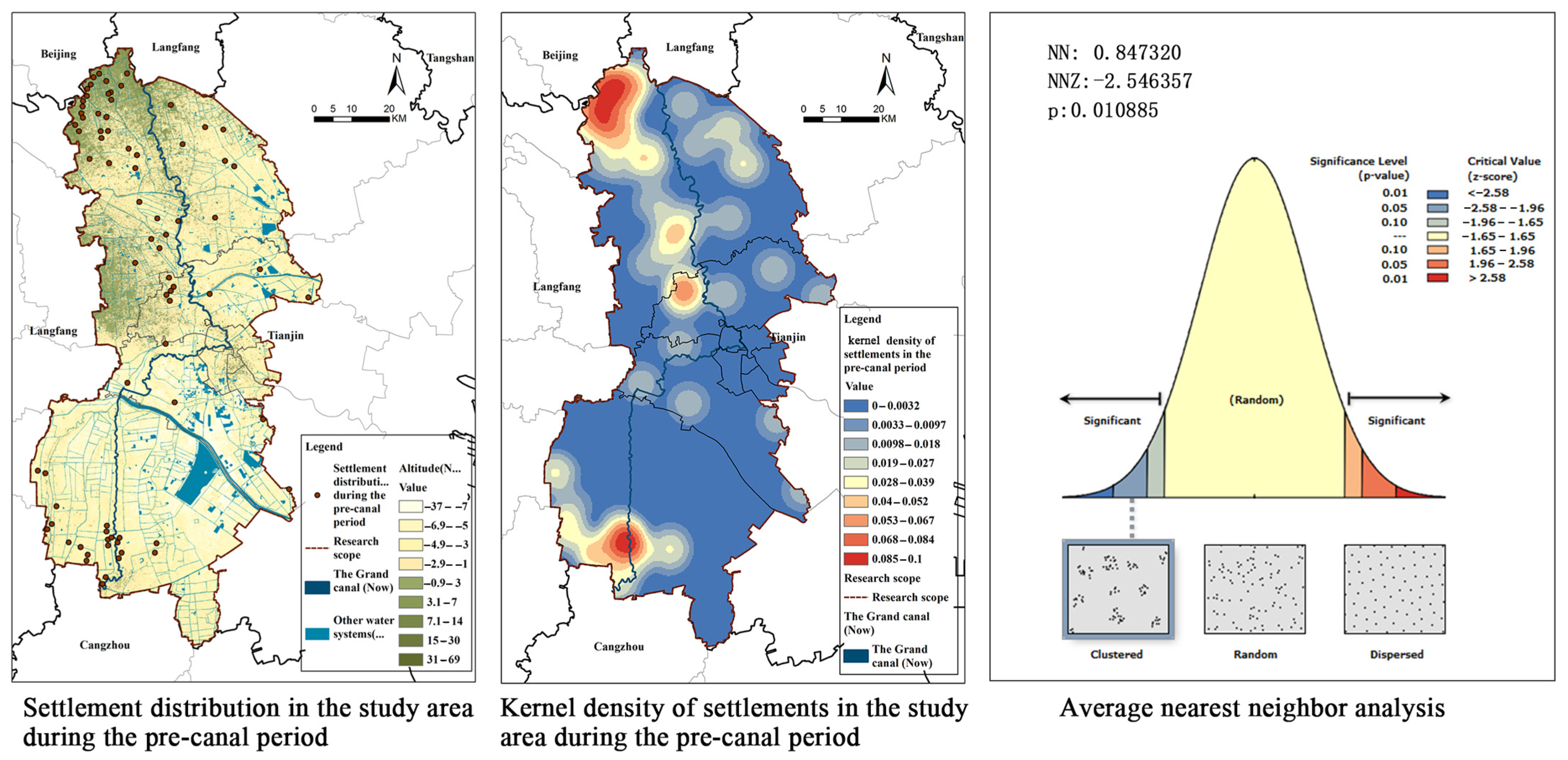
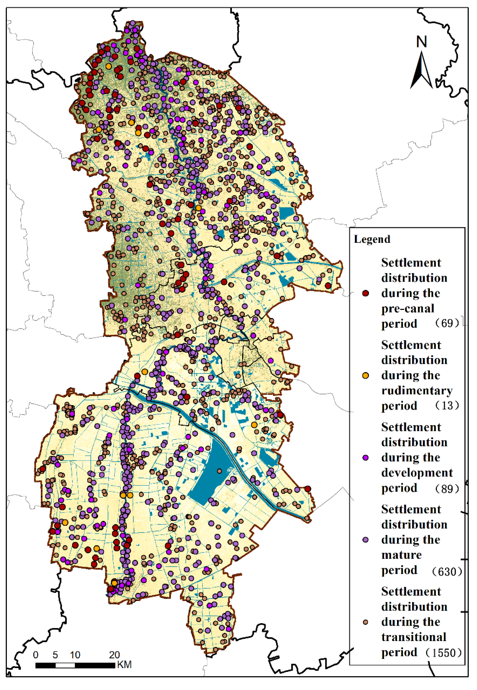
There are totally 69 settlement relics of the pre-canal period in the survey region (from the primitive society to the Han Dynasty principally distributed in Wuqing District and southern Jinghai District and rarely in Beichen District and Xiqing District (Figure 6). As the kernel density analysis shows, the high-value area is mostly in Gaocun Town, Dawanggu Town, Baigutun Town, Hexiwu Town, Chengguan Town, Sicundian Town and Huangzhuang Town in Wuqing District and Chenguantun Town, Yanzhuang Town, Liuhe Town, Wangkou Town and Xizhaizhuang Town in Jinghai District. The average nearest-neighbor analysis result indicates that the nearest-neighbor rate is 0.85, the z score is −2.54 and the settlement relics of the pre-canal period are in “multikernel” aggregate distribution.

3.2. The Rudimentary Period of the Settlement Space: The Wei, Jin, Northern and Southern Dynasties and the Sui and Tang Dynasties (AD220–AD916)

The rudimentary period (AD220–AD916) of the settlement space along the canal chiefly is composed of the Wei, Jin, Northern and Southern Dynasties (AD220–AD589) and the Sui and Tang Dynasties (AD581–AD916).

3.2.1. The Digging and Formation of the Grand Canal Tianjin Section

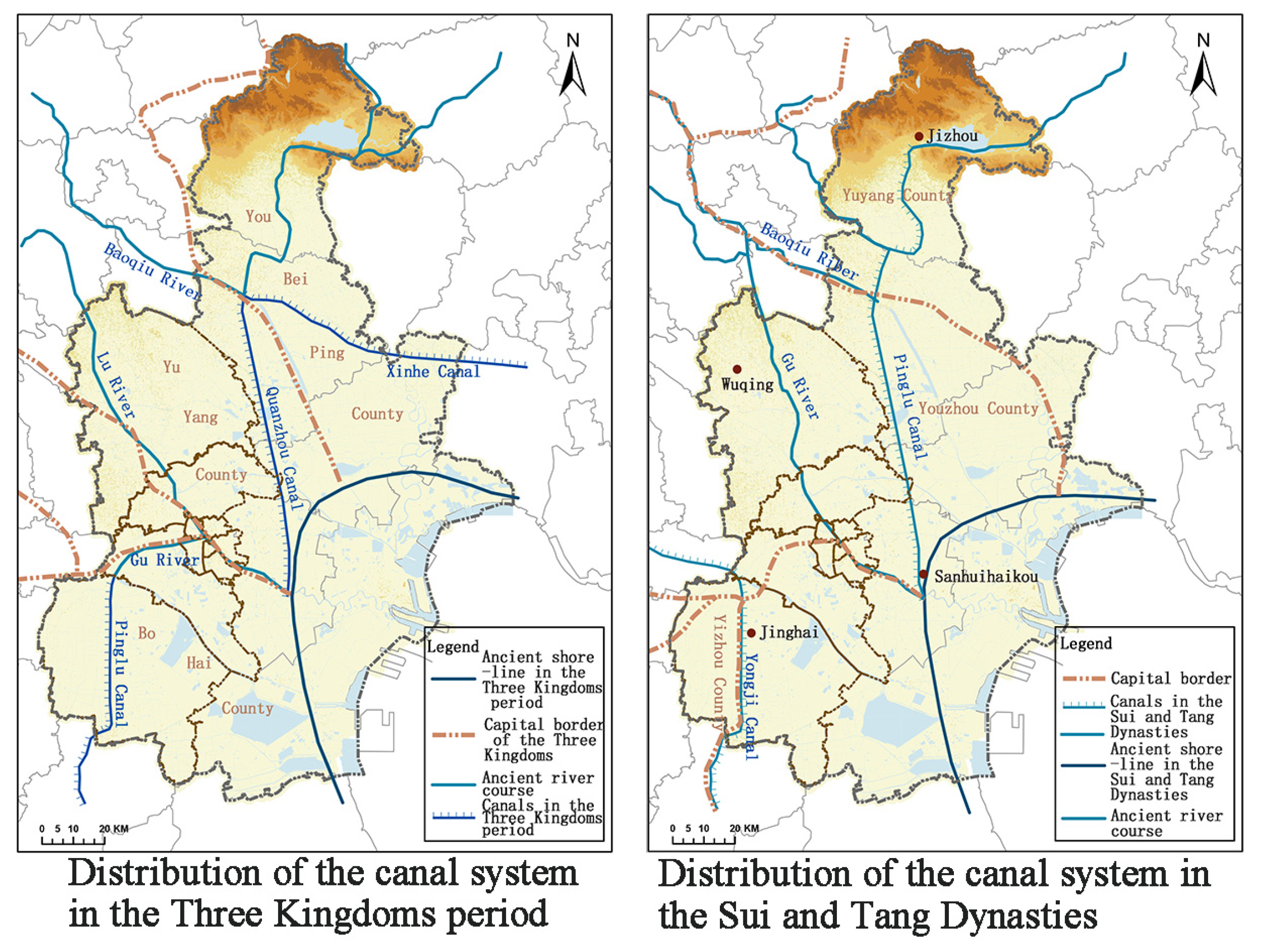
The digging of the Grand Canal Tianjin Section can stretch back to the Eastern Han and Wei Dynasties at the earliest. For military needs, three artificial canals, namely, the Pinglu Canal, Quanzhou Canal and Xinhe Canal, were dug there to transport grain (Figure 7) [37]. The opening of the three artificial transportation canals could defend the western and eastern parts of Liaoning Province and implement the military strategies of connecting with Hebei Plain [37]. These canals surrounded the western and northern parts of the Bohai Bay, cut through Tianjin Plain and linked the Luanhe River and the Central Plain River system with the Yellow River in the center, which was a pioneering work in the history of Chinese canals. To stabilize this unification, the Sui Dynasty spared no efforts to dig the canal and linked the South Canal and the North Canal on the basis of dredging, changing and expanding the previous canals [37]. The Haihe river system in Tianjin was reshaped due to the digging of the Yongji Canal. In 608, Emperor Yang of the Sui Dynasty ordered the digging of the Yongji Canal which ran past the present Duliu Town in Jinghai County, then westwards and finally to Beijing via Xin’an Town, Yongqing County and Anci District, etc. The Yongji Canal was a northern trunk of the canal system in the Sui Dynasty and the main river course to transport army provisions and supplies for northern frontier defense in the Tang Dynasty. The digging and control of the canal mostly referred to dredging and mending in the Tang Dynasty. The Quanzhou Canal was redug for military needs to link Yuyang County and Junliangcheng Town and was renamed Pinglu Canal. The canal digging in Tianjin facilitated the development and prosperity of the cities and rural settlements along the canals.

3.2.2. Cultural Relics Distribution Characteristics

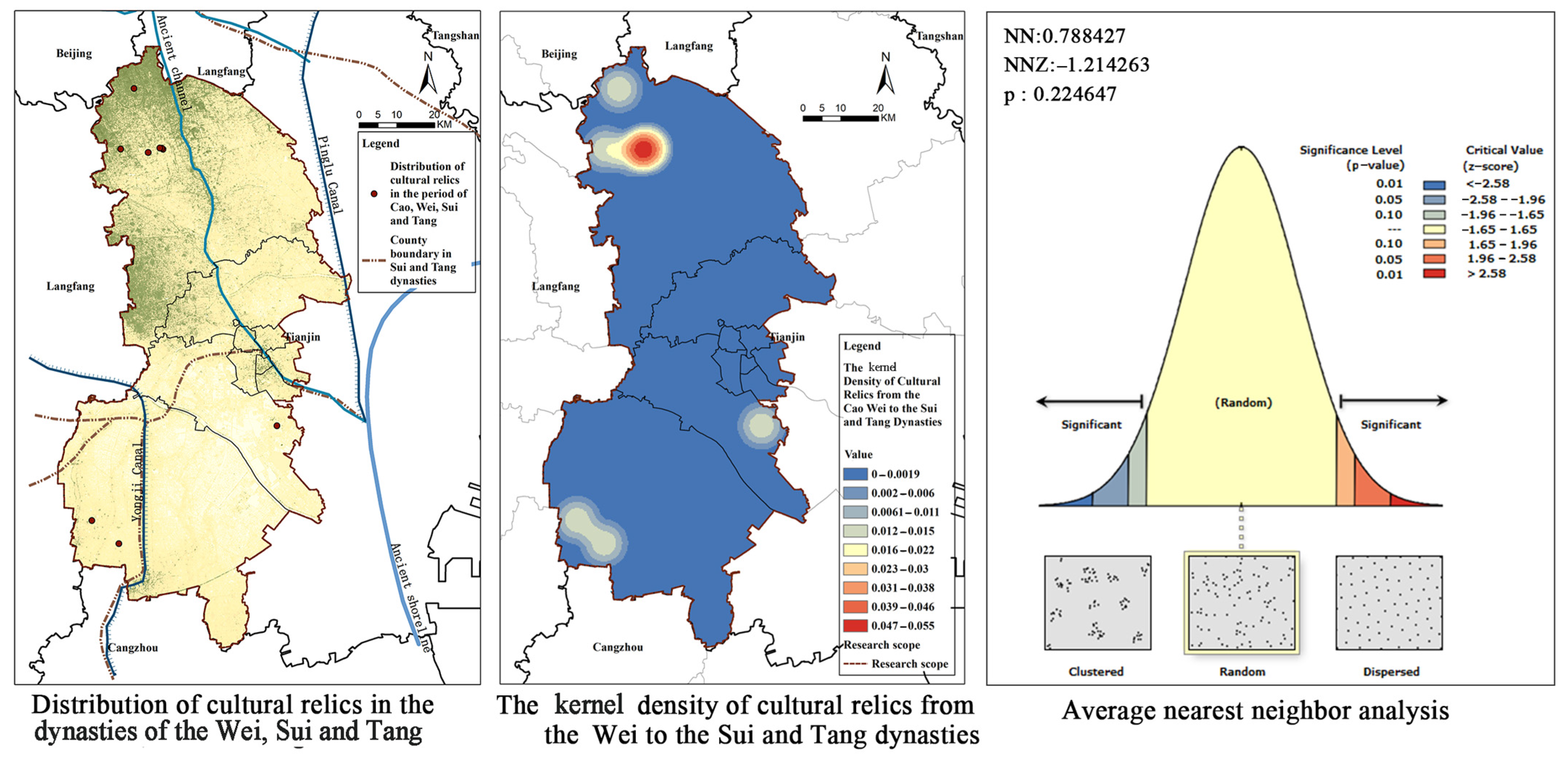
The economy of Tianjin Plain did not recover in the Wei and Jin Dynasties. Yongnu County of the Northern Wei Dynasty still exists in the survey region, the Dataizi Ancient City in Wuqing District. The southern part of Chengzhuangzi Village in Jinghai District is an ancient city. Dangcheng County in the southwest of Yangliuqing Town is the site of Yicheng Ancient City [35]. The Yongji Canal ran through Dongshuangtang Village and Xishuangtang Village in Jinghai District in the Sui and Tang Dynasties. Besides, the tombs of the Sui Dynasty were found in Wang’er Village of Ziya Town and Zhangcun Village of Yanzhuang Town in Jinghai District [37]. Totally, nine cultural relics were discovered in the survey region, including one relics of the former city, four settlements, one ancient architecture and two tombs. As the kernel density analysis indicates, the high-value area mostly is composed of Jiuxian Village of Sicundian Town, Lancheng Village of Caocun Town, Dataoyuan Village of Chengguan Town and Dongzhangying Village in Wuqing District, followed by Wang’er Village of Ziya Town and Zhangcun Village of Yanzhuang Town in Jinghai District and Wangcun Village of Dasi Town in Xiqing District (Figure 8). The average nearest-neighbor analysis result indicates that the nearest-neighbor rate is 0.79, the z score is −1.21 and the cultural relics of the rudimentary period are in “random” distribution. In 446, the Northern Wei Dynasty abolished Quanzhou Town and integrated it into Yongnu County in Jiuxian Village of Wuqing District. Two sites of the Tang Dynasty were discovered at the ruins of Yongnu County, namely, the ruins of Sitaizi Village 150 m away and Tianqi Temple 400 m away from the southern part of the village. A huge amount of cultural relics of the Sui and Tang Dynasties was unearthed in Sitaizi Village, including celadon bowls and tri-color pot relics of the Tang Dynasty [35]. The historical site of Tianqi Temple covers an area of 3600 m2, where the Monument to Dongyuexinggong Taoist Temple, the stone tablet and tablet inscription written in 1744 were unearthed. The writings record the process of the initial construction in the Tang Dynasty, the reconstruction in the Yuan Dynasty and the third construction in the Qing Dynasty.

3.2.3. Settlement Distribution Characteristics

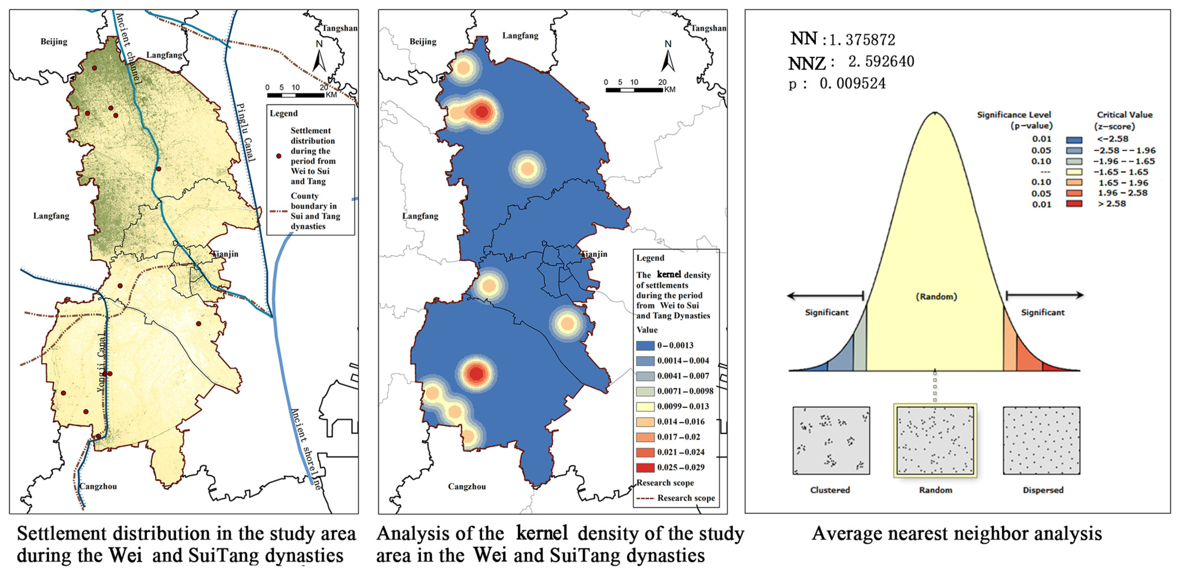
The settlement relics along the canal in the rudimentary period (from Wei to Sui and Tang Dynasties) in the survey region totaled 13 (Figure 9), principally distributed in Wuqing District and southern part of Jinghai District and scarcely in Xiqing District. As the kernel density analysis manifests, the high-value area is chiefly in Gaocun Town, Chengguan Town, Sicundian Town and Yangcun Town in Wuqing District, Yanzhuang Town and Wangcun Town in Jinghai District and Dasi Town in Xiqing District. The average nearest-neighbor analysis result indicates that the nearest-neighbor rate is 1.38, the z score is 2.59 and the settlement relics in the pre-canal period are in random “multipoint-disperse” distribution.

3.3. The Development Period (AD916–AD1368) of the Settlement Space along the Canal: The Song and Liao Dynasties (AD916–AD1276), the Jin Dynasty (AD1115–AD1234) and the Yuan Dynasty (AD1206–AD1368)

The development period (AD916–AD1368) of the settlement space along the canal chiefly is composed of the Song and Liao Dynasties (AD916–AD1276), the Jin Dynasty (AD1115–AD1234) and the Yuan Dynasty (AD1206–AD1368).

3.3.1. Rechanneling and Connection of the Grand Canal Tianjin Section

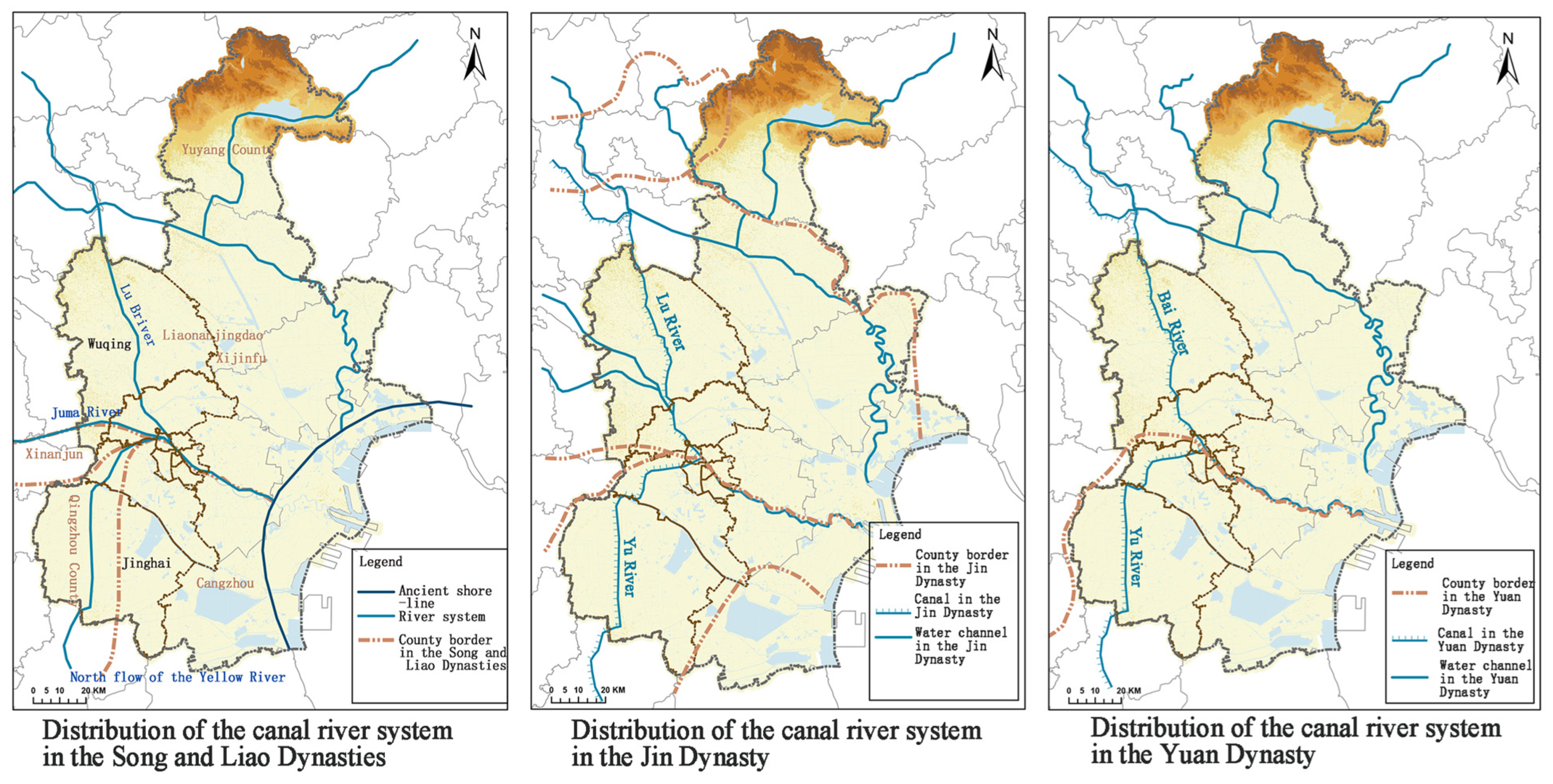
With the northward flow of the Yellow River into the Yuhe River (Yongji Canal) in Tianjin, the shoreline in Tianjin further moved eastward, and the outline of the plain in coastal region of Tianjin basically took shape. After the Yellow River began flowing into Tianjin, the river banks burst, and floods frequently occurred in decades. The Yellow River flowed into the sea and rechanneled twice in 1049 and 1081 until it left Tianjin and flowed into the sea via the Huaihe River. In the Song and Liao Dynasties (Figure 10), the Song Dynasty chose Bianliang for its capital after the Five Dynasties period, and the Liao Dynasty chose Shangjing for its capital and “Liao” as its state title. The two dynasties took the “boundary river” as the boundary and set quantities of “villages” on both banks of the river for defense. The “boundary river” in the center of Tianjin links Bazhou and Xin’an to the west of Tianjin and stretches to the Nigu Sea in Tianjin. In the Song Dynasty, efforts were made to construct boundary city walls and moats, dredge the river course and open grain transportation in Guannan to strengthen defense. Moreover, the Liao Dynasty took the geographical advantages of being to the north of the “boundary river” and developed grain and salt transportation under the premises of satisfying the requirements of defense.
In 1153, the Jin Dynasty chose Zhongdu (Beijing) for its capital. Each year, a great number of goods were transported there, and Tianjin became the core hub of grain transportation from south to north. The grain canal in the early Jin Dynasty was still the Yongji Canal dug in the reign of Emperor Yang of the Sui Dynasty. It turned westward and flew by Bazhou, Yongqing and Anci to Tongzhou. In 1205, to guarantee grain and salt transportation, the canal was rechanneled via Liukou to the Sancha River Estuary and via the Lushui River (the northern canal) to Tongzhou. The Sancha River Estuary set Zhigu Village to serve as an important intersection of grain transportation. In 1272, the Yuan Dynasty unified China and chose Dadu (Beijing) for its capital. With the rising demand for grain transportation in the Yuan Dynasty, the original river course was often blocked up due to the rechanneling of the Yellow River, and hence the dynasty went in for sea transportation in a big way. In 1316, Haijin Town was set in Zhigu, further cementing the position of Tianjin as the hub of grain transportation and ushering in Tianjin’s urbanization. Grain transportation by either river transportation or sea transportation afterwards was transferred to the capital via Tianjin.

3.3.2. Cultural Relics Distribution Characteristics

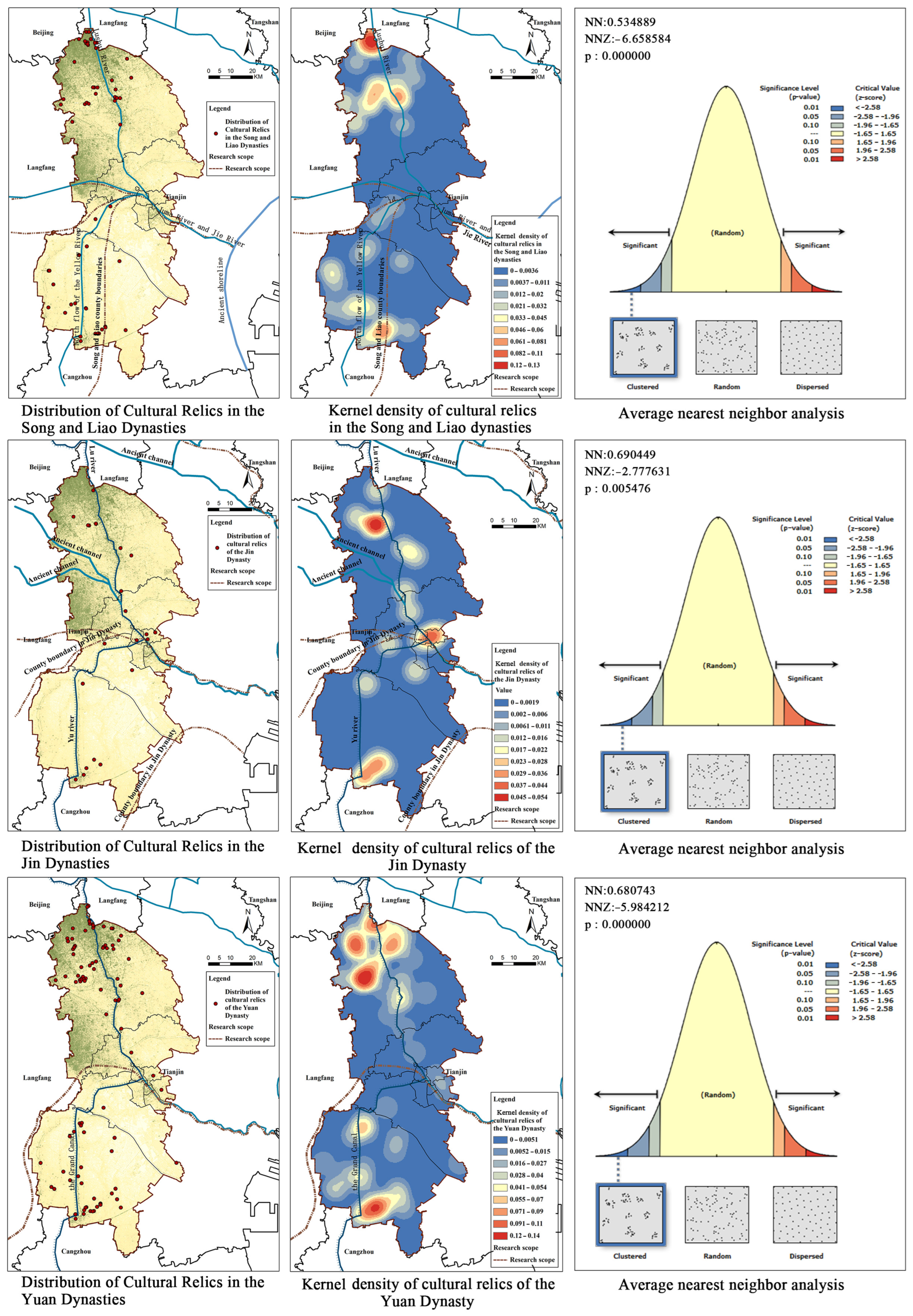
Grossly, 56 cultural relics of the Song and Liao Dynasties were discovered in the survey region, including 13 ancient tombs, 40 ancient sites, one irrigation works, one river course relics and one inscription relics, 33 of which are in Wuqing District, 21 in Jinghai District and two in Xiqing District (Figure 11). As the kernel density analysis shows, the high-value area is chiefly in Hexiwu Town, Sicundian Town and Nancaicun Town in Wuqing District, followed by Tangguantun Town, Chenguantun Town, Yanzhuang Town, Duliu Town and Wangkou Town in Jinghai District and scarcely in Yangliu Town and Xinkou Town in Xiqing District. The average nearest-neighbor analysis result indicates that the nearest-neighbor rate is 0.53, the z score is −6.66 and the cultural relics of the Song and Liao Dynasties are in random “multikernel” distribution. The line of defense was built at the boundary river in the Song Dynasty, and there are historical sites of forts and walls of Dangcheng County and Diaotai Village covering about 40,000 m2 in the survey region [35]. The Song and Liao Dynasties transported huge quantities of various foods to Tianjin, objectively stimulating the commercial and trading transactions of the two countries. There is a building with Buddhism lection and joss in Wawu Village, Dashahe Town, Wuqing District with the ruins standing 1.7 m.
Zhigu Village at the Sancha River Estuary in the Jin Dynasty built walls and boasted more than 5000 soldiers, making Tianjin a pivotal military town. A massive number of ancient wastelands were built into villages. Totally, 22 cultural relics of the Jin Dynasty were discovered in the survey region, including two ancient architectures, 14 ancient sites, one ancient tomb, one irrigation facility and four river course relics, 33 of which are in Wuqing District, 21 in Jinghai District and two in Xiqing District. As the kernel density analysis displays (Figure 11), the high-value area is chiefly in Damengzhuang Town, Baigutun Town and Sicundian Town in Wuqing District, Tangguantun Town and Xizhaizhuang Town in Jinghai District, Hongqiao District and Hebei District in the city center. The average nearest-neighbor analysis result indicates that the nearest-neighbor rate is 0.69, the z score is −2.78 and the cultural relics of the Jin Dynasty are in random “belt + multikernel” distribution.
Totally, 97 cultural relics of the Yuan Dynasty were discovered in the survey region, including one ancient architecture, 83 ancient sites, four ancient tombs, seven irrigation facilities and two river course relics, 57 of which are in Wuqing District, 34 in Jinghai District and a few in Xiqing District, Hedong District, Nankai District and Beichen District. As the kernel density analysis displays (Figure 10), the high-value area is chiefly in Hexiwu Town, Baigutun Town, Daliang Town, Xiawuqi Town, Xuguantun Town and Yangcun Town in Wuqing District and Liangwangzhuang Town, Tangguantun Town, Chenguantun Town, Xizhaizhuang Town and Yanzhuang Town in Jinghai District. The average nearest-neighbor analysis result indicates that the nearest-neighbor rate is 0.68, the z score is −5.98 and the cultural relics of the Yuan Dynasty are in “belt+multikernel” distribution. The former sites of 14 granaries and massive relics of grain transportation of the Yuan Dynasty were discovered in Wuqing District. Hexiwu Town was the largest peripheral warehousing base in the Yuan Dynasty. These warehousing bases are chiefly distributed in Dongxican Village, 3 km away from the northwest of present Hexiwu Town, abounding in underground cultural relics. At the same time, the relics of grain transportation wharves were discovered there, where large quantities of cultural relics were unearthed, including groove pattern bricks, plain round tiles, chinaware, bronze mirrors and ink stones.

3.3.3. Settlement Distribution Characteristics

In the development stage of the settlements along the canal, grossly 91 settlements were discovered in the survey region. As the kernel density analysis displays (Figure 12), the high-value area is chiefly in Wubaihu Town, Hexiwu Town, Xiwuqi Town, Daliang Town, Nancaicun Town, Damengzhuang Town, Baigutun Town, Sicundian Town, Xuguantun Town, Cuihuangkou Town, Yangcun Town, Beicang Town, Yangliuqing Town and Xinkou Town in Xiqing District and Tangguantun Town, Yanzhuang Town, Ziya Town, Duliu Town, Wangkou Town, Chenguantun Town and Zhongwang Town in Jinghai District. The average nearest-neighbor analysis result indicates that the nearest-neighbor rate is 0.89, the z score is −2.01 and the settlements in the development period are in “belt + multikernel” distribution. The social economy gained great momentum in that period.

3.4. The Mature Period (AD1368–AD1912) of the Settlements along the Canal: The Ming Dynasty (AD1368–AD1644) and the Qing Dynasty (AD1616–AD1912)

The mature period (AD1368–AD1912) of the settlement space along the canal chiefly comprises the Ming Dynasty (AD1368–AD1644) and the Qing Dynasty (AD1616–AD1912).

3.4.1. The Thriving of the Grand Canal Tianjin Section

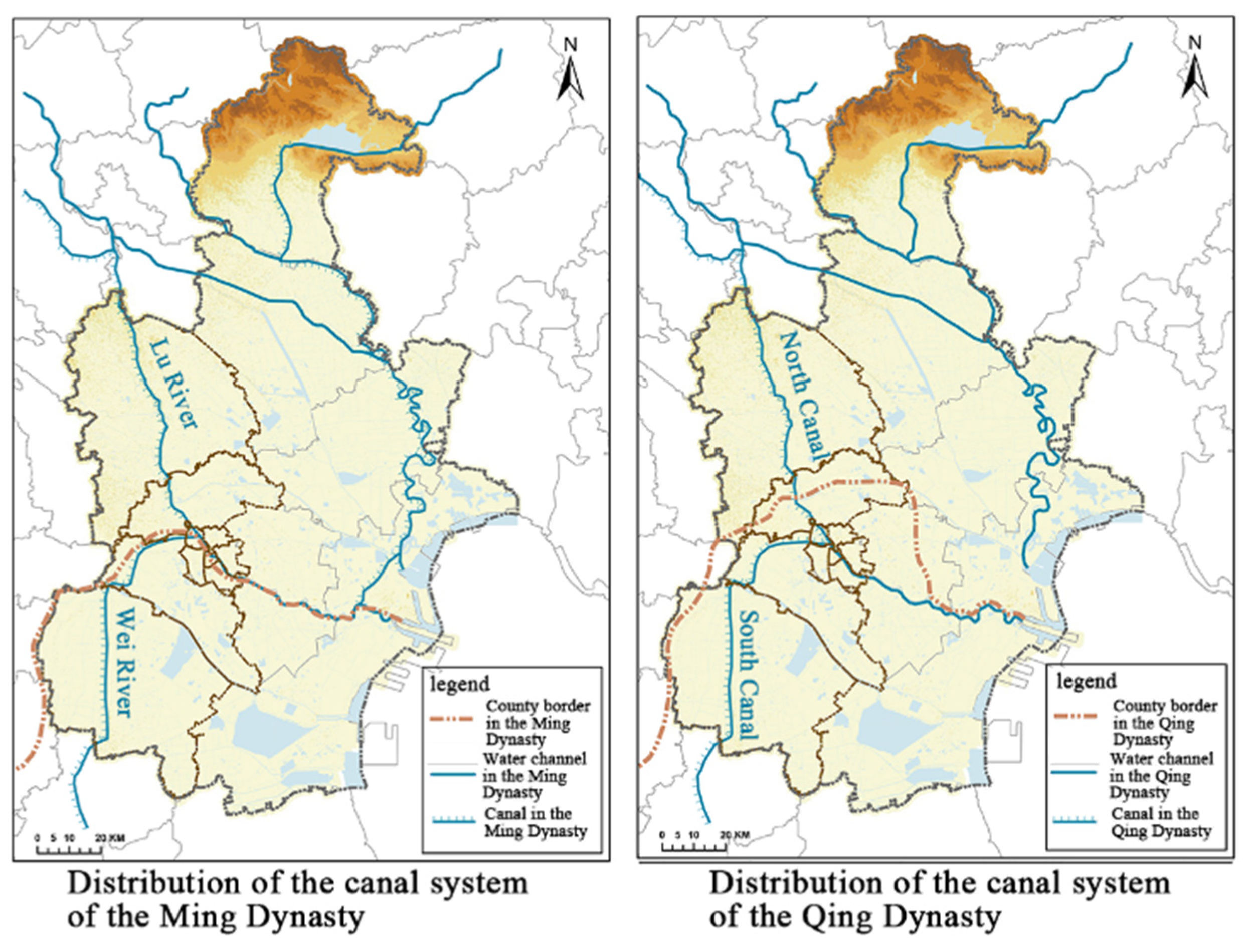
In 1421, the Ming Dynasty moved its capital to Beijing, and the whole line of the Grand Canal of China was connected. Each year, 2.5–3 billion kg of grain were transported to Beijing. Tianjin, in a strategically important place boasting rivers and seas, rapidly developed in grain transportation (Figure 13). In the Ming Dynasty, grain transportation was combined with river and sea transportation at the earliest. Later, the canal was revamped, and heavy-load grain transportation vessels adopted chiefly river transportation supplemented by sea transportation. It was not until 1415 that sea transportation stopped; only river transportation was adopted; and the whole line of the canal stretching more than 1700 km was totally connected. Tianjin became a pivotal trade route connecting logistics between southern and northern China, attracting seas of merchants and commodities and seeing market prosperity. Tianjin became the hub of grain transportation and the base of coastal defense in the Ming Dynasty. In the Qing Dynasty, the canal served as the economic lifeline linking southern and northern China, and the position of Tianjin as the central terminal station of the canal was highlighted.

3.4.2. Cultural Relics Distribution Characteristics

In 1404, the Ming Dynasty constructed garrisons for defense in Tianjin, which was a monumental event in the history of development of ancient Tianjin. According to The History of the Ming Dynasty—Geographica, setting up garrison in Tianjin marked that the settlements of villages and towns began to evolve into settlements of cities and towns [35]. In the Ming Dynasty, stationing troops to open up wasteland was an important reason for settlement development. To consolidate the regime, migrants flooded the surrounding area to open up wasteland, grow grain and set up villages in Tianjin. Meanwhile, troops applied reclamation of wasteland, and a colossal number of settlements along the canal were constructed at that time. Totally, 104 cultural relics were discovered in the survey region, including nine ancient architecture, 18 ancient tombs, 65 ancient sites, two irrigation facilities, three river course relics and seven inscription relics, 39 of which are in Wuqing District, 34 in Jinghai District, 14 in Xiqing District, nine in Beichen District, four in Nankai District and four in Hebei District. As the kernel density analysis displays (
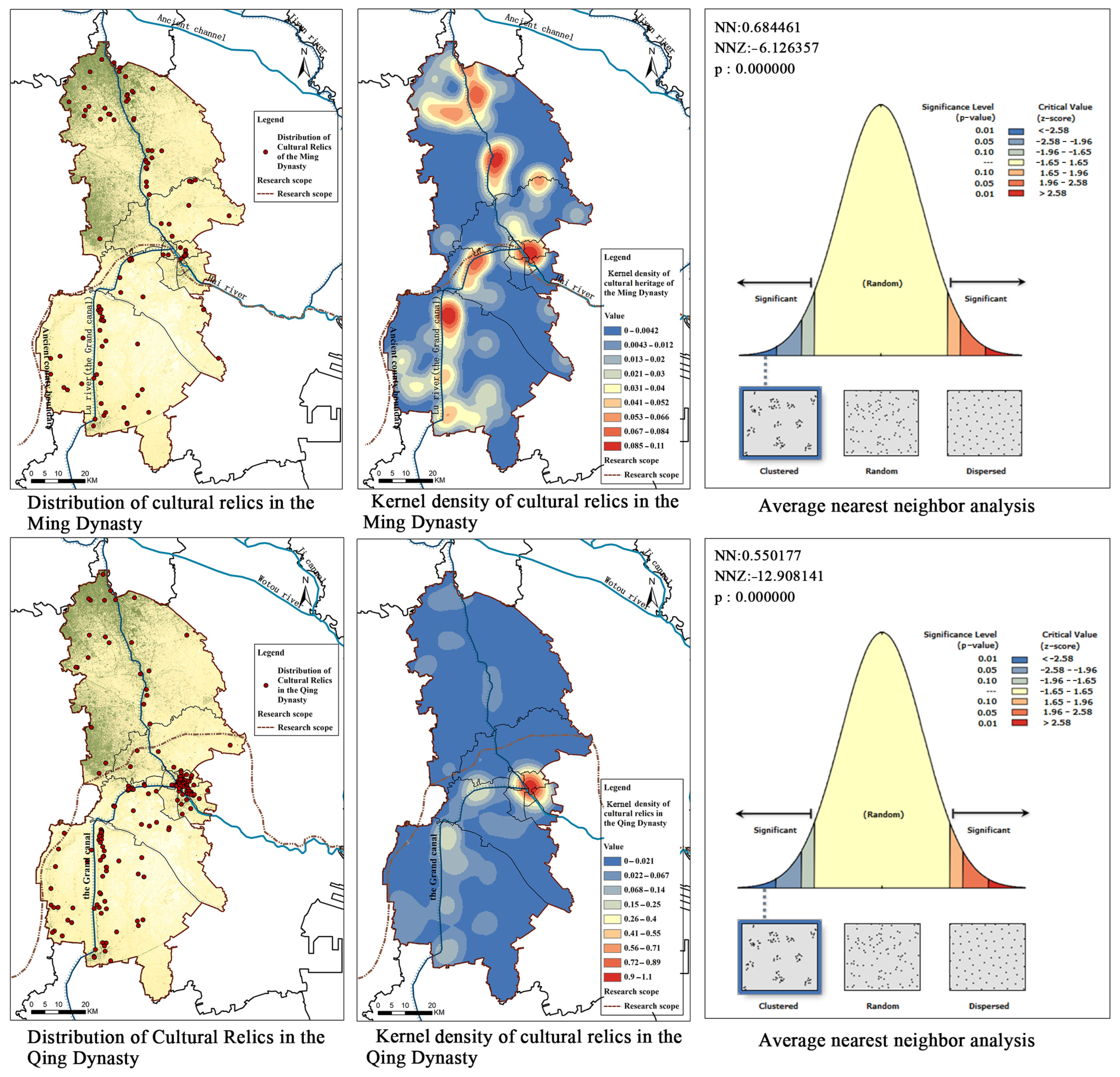
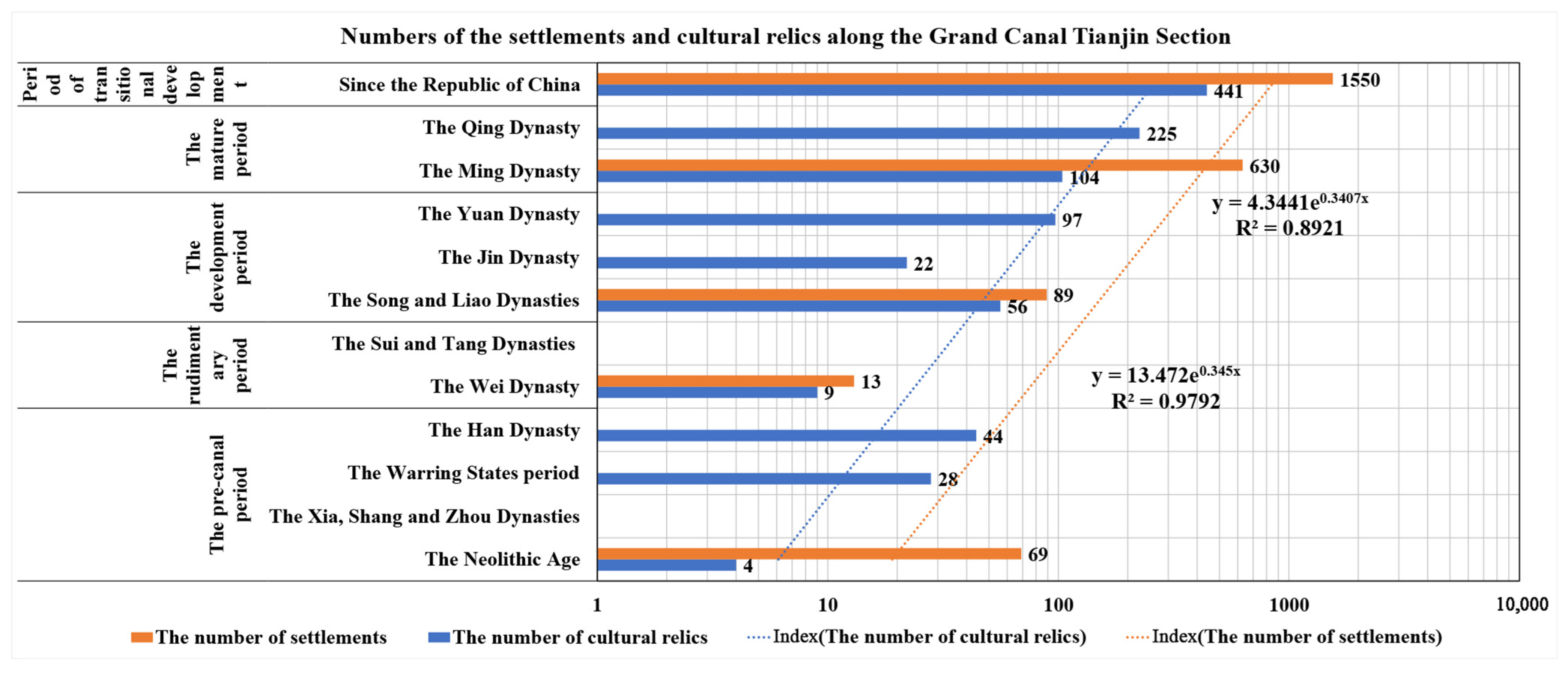
Figure 14), the high-value area is chiefly in Hexiwu Town, Xiawuqi Town, Daliang Town, Damengzhuang Town, Chengguan Town, Baigutun Town, Sicundian Town, Nancaicun Town, Xuguantun Town, Xiazhuzhuang Street, Yangcun Street, etc., in Wuqing District, Beicang Town and Tianmu Town in Beichen District, Hongqiao District and Hebei District in the city center, Yangliuqing Town and Xinkou Town in Xiqing District and Duliu Town, Liangwangzhuang Town, Jinghai Town, Shuangtang Town, Ziya Town, Chenguantun Town, Tangguantun Town and Yanzhuang Town in Jinghai District. The average nearest-neighbor analysis result indicates that the nearest-neighbor rate is 0.68, the z score is −6.12 and the cultural relics of the Ming Dynasty in the survey region are in the “one belt + multikernel” distribution on both banks of the canal.
Tianjin changed from a garrison city in the Ming Dynasty to a prefectural city in the Qing Dynasty. It served as a hub of grain transportation, a key position in coastal areas and territorial seas, a commercial center in northern China and the Changlu Salt Management Center. As the portal to the capital city, Tianjin became a gathering place of merchants and elite housing in great numbers. Totally, 225 cultural relics were discovered in the survey region, including 33 ancient architectures, 17 ancient tombs, 46 ancient sites, eight irrigation facilities, two river course relics, 38 inscription relics and 81 important historical sites and representative architectures in modern times, 68 of which are in Jinghai District, 37 in Hongqiao District, 29 in Xiqing District, 26 in Hebei District, 24 in Wuqing District, 22 in Heping District, eight in Nankai District, six in Hedong District and five in Beichen District. As the kernel density analysis displays (Figure 14), the high-value area is chiefly in Hongqiao District, Hebei District and Heping District in the city center, Hexiwu Town, Baigutun Town, Daxianchang Town, Xuguantun Town, Yangcun Street, etc., in Wuqing District, Yangliuqing Town, Xinkou Town and Zhongbei Town in Xiqing District and Duliu Town, Liangwangzhuang Town, Jinghai Town, Shuangtang Town, Ziya Town, Chenguantun Town, Tangguantun Town and Yanzhuang Town in Jinghai District. The average nearest-neighbor analysis result indicates that the nearest-neighbor rate is 0.55, the z score is −12.9 and the cultural relics of the Ming and Qing Dynasties in the survey region are in the “unikernel + one belt + multipoint” distribution.

3.4.3. Settlement Distribution Characteristics

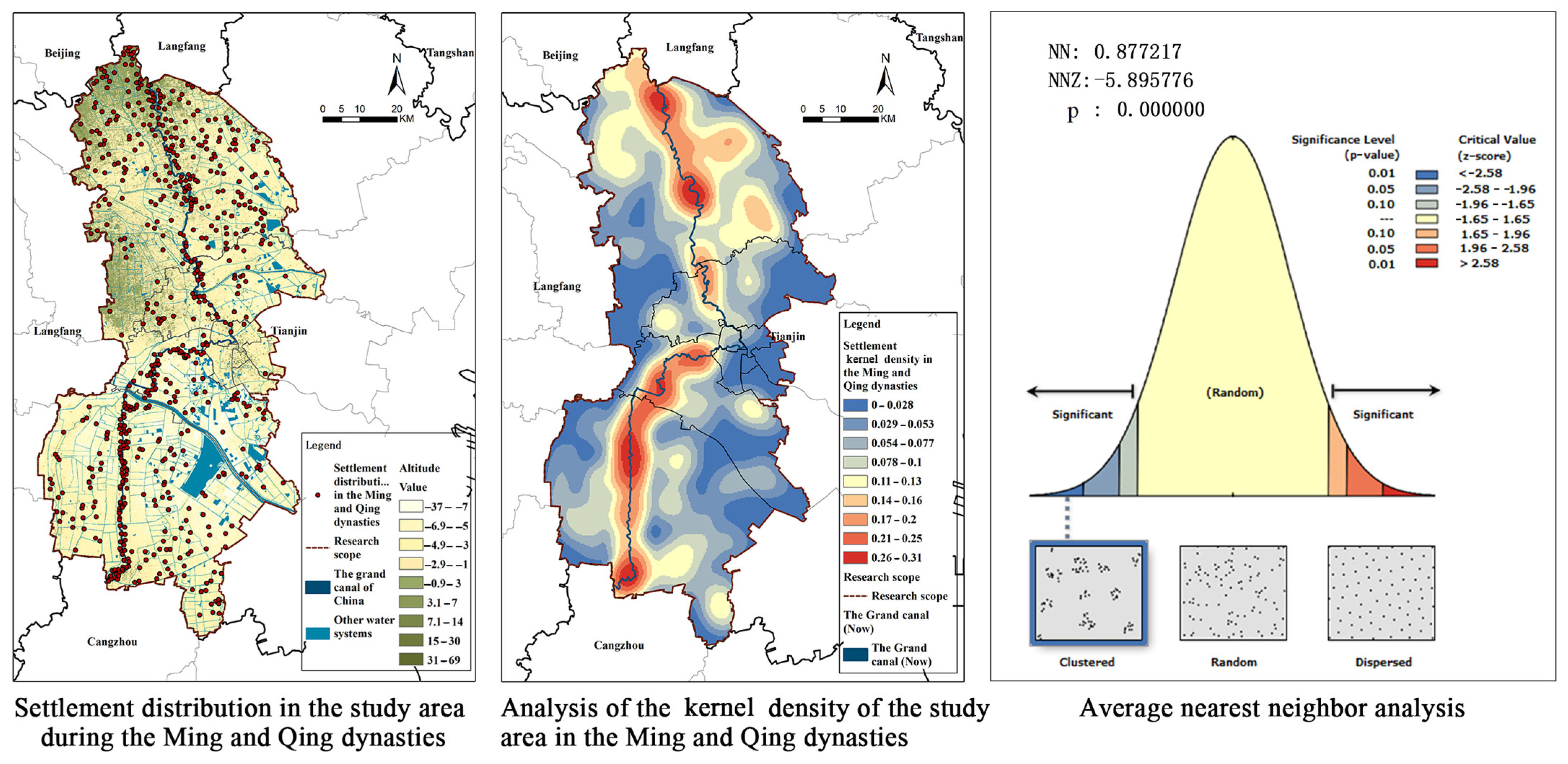
The historical data indicate that there are altogether 630 settlements of the Ming and Qing Dynasties in the survey region. The kernel density analysis shows that (Figure 15) the settlements on both banks of the South Canal and North Canal have conspicuous characteristics. The high-value area in Wuqing District chiefly is composed of Hexiwu Town, Xiawuqi Town, Damengzhuang Town, Daliang Town, Nancaicun Town, Daxianchang Town, Xuguantun Town, Yangcun Street and the surrounding Baigutun Town, Chengguan Town and Cuihuangkou Town. The high-value area in Beichen District primarily consists of Shuangjie Town, Beicang Town and surrounding Shuangkou Town along the canal. The high-value area in Xiqing District is composed of Zhongbei Town, Yangliuqing Town, Xinkou Town along the canal and surrounding Zhangjiawo Town. The high-value area in Jinghai District consists of Liangwangzhuang Town, Duliu Town, Jinghai Town, Shuangtang Town, Chenguantun Town, Tangguantun Town adjacent to the canal and surrounding Liangtou Town, Ziya Town, Yanzhuang Town and Xizhaizhuang Town. The average nearest-neighbor analysis result indicates that the nearest-neighbor rate is 0.88 and the z score is −5.89. It shows that the cultural relics in the survey region in the mature period of settlements along the canal are in the “stripe + multikernel + splattering” distribution.

3.5. The Transformation Period (AD1912–Now) of the Settlement Space along the Canal: Since the Republic of China (AD1949–Now)

The transformation period (AD1912–now) of the settlement space along the canal chiefly is composed of the modern times (AD1912–AD1949) and the People’s Republic of China (AD1949–now).

3.5.1. The Vicissitudes and Revitalization of the Grand Canal Tianjin Section

Modern China has been threatened by extinction, social turmoil and government downfall. In 1855, the Yellow River burst, cut through the canal and the Daqing River and flowed into the Bohai Sea, resulting in silting-up of the river course of the canal. Afterwards, grain was transported by sea to Tianjin and then to Beijing via the Haihe River and the North Canal (Figure 16). In 1904, the Grand Canal of China, except the Jiangsu Section and the Hangzhou Section, saw the grain transportation in other sections crippled, and the function of the Grand Canal Tianjin Section for grain transportation ended. After the People’s Republic of China was founded in 1949, some sections of the canal were recovered and expanded in construction. The South-to-North Water Diversion Project was gradually launched. In the 1960s and 1970s, due to the dammed-up project construction in the upper reaches of the drainage basin and the increase of water use in addition to droughts in successive years in North China, Tianjin was reduced to a city lacking water resources. The South-to-North Water Diversion Project changed the current status of the water resources in Tianjin, and the North Canal opened up normal water replenishing routes and yielded remarkable effects. In June 2014, the Grand Canal of China was nominated to be a world cultural heritage site, and the conservation, inheritance and utilization of the canal ushered in the best opportunities.

3.5.2. Cultural Relics Distribution Characteristics

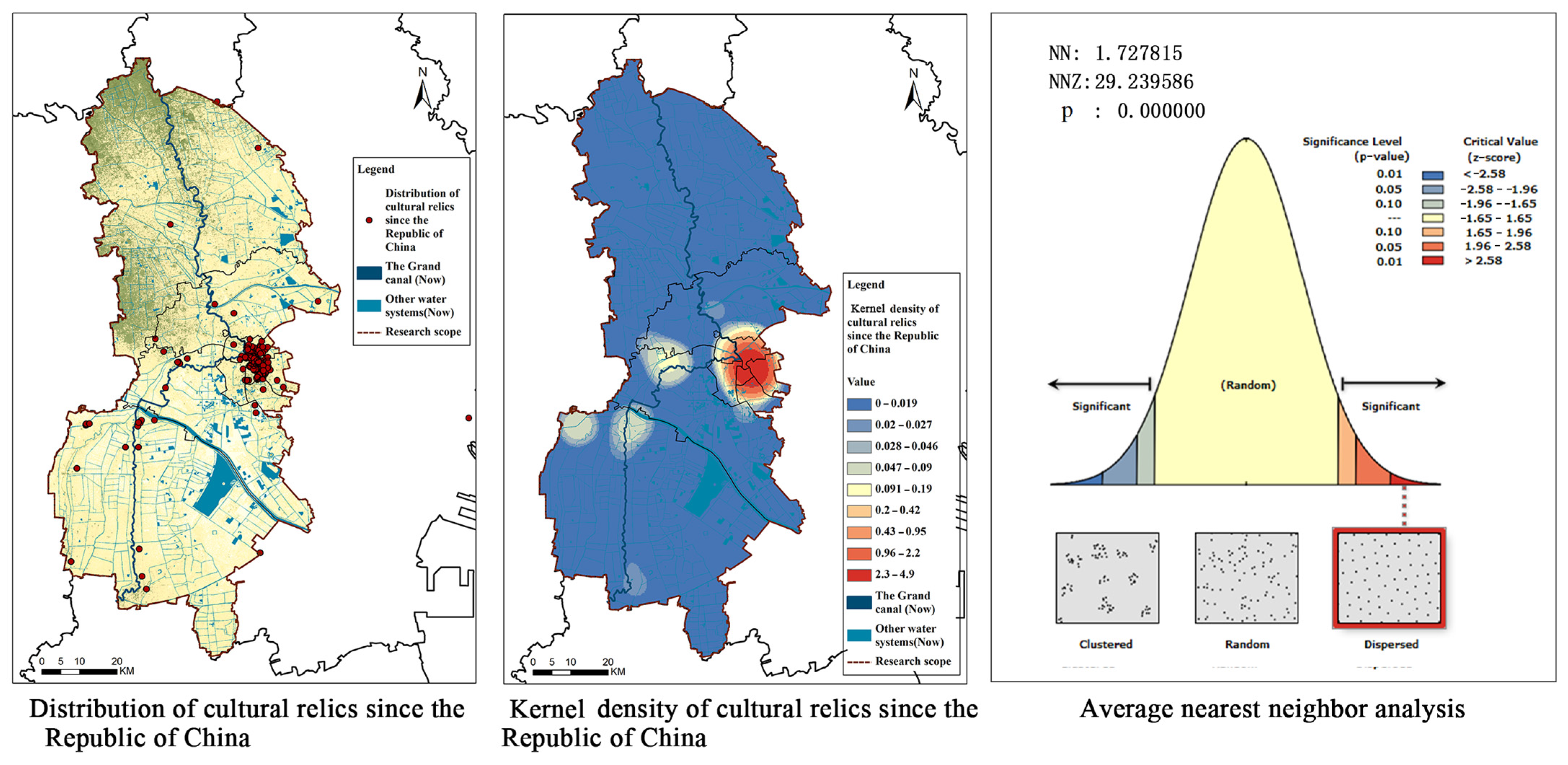
Grossly, 441 cultural relics of the Republic of China were discovered in the survey region, including one ancient architecture, one ancient tomb, three irrigation facilities, four inscription relics and 429 important historical sites and representative architectures in modern times. In this period, the area of the densest distribution of cultural relics has changed from suburban Wuqing District and Jinghai District to the city center, including 258 in Heping District, 93 in Hebei District, 27 in Hongqiao District, 17 in Nankai District, nine in Hedong District, three in Wuqing District, 18 in Jinghai District and 10 in Xiqing District. The kernel density analysis indicates (Figure 17) that the high-value area is mostly in the city center and the cultural relics are primarily former residences or sites of celebrities, administrative departments, schools, enterprises and stores, etc. The average nearest-neighbor analysis result indicates that the nearest-neighbor rate is 1.75, the z score is 29.24 and the cultural relics of the Republic of China in the survey region are in “unikernel + multipoint” disperse distribution.

3.5.3. Settlement Distribution Characteristics

Tianjin before port opening featured dense distribution of settlements and populations in the villages and towns along the canal. The settlements of the largest population were at the fork of the canal and surrounding river courses and displayed a strong hydrophily [39]. The Sancha River Estuary at the intersection of the South Canal, the North Canal and the Haihe River has developed to be a city center, featuring a dense distribution of settlements along the canal and the Haihe River and surrounding sparse villages far away from the rivers. At that time, the formation and development of the settlements along the Grand Canal Tianjin Section had close connections with land and water transportation and business transactions. In 860, after the Second Opium War, Tianjin was forced to open its port and construct the new district in Hebei, which objectively prompted the modern urban development of Tianjin. With the decline of the function of the canal, the settlements along the Grand Canal Tianjin Section gradually lost their central position.
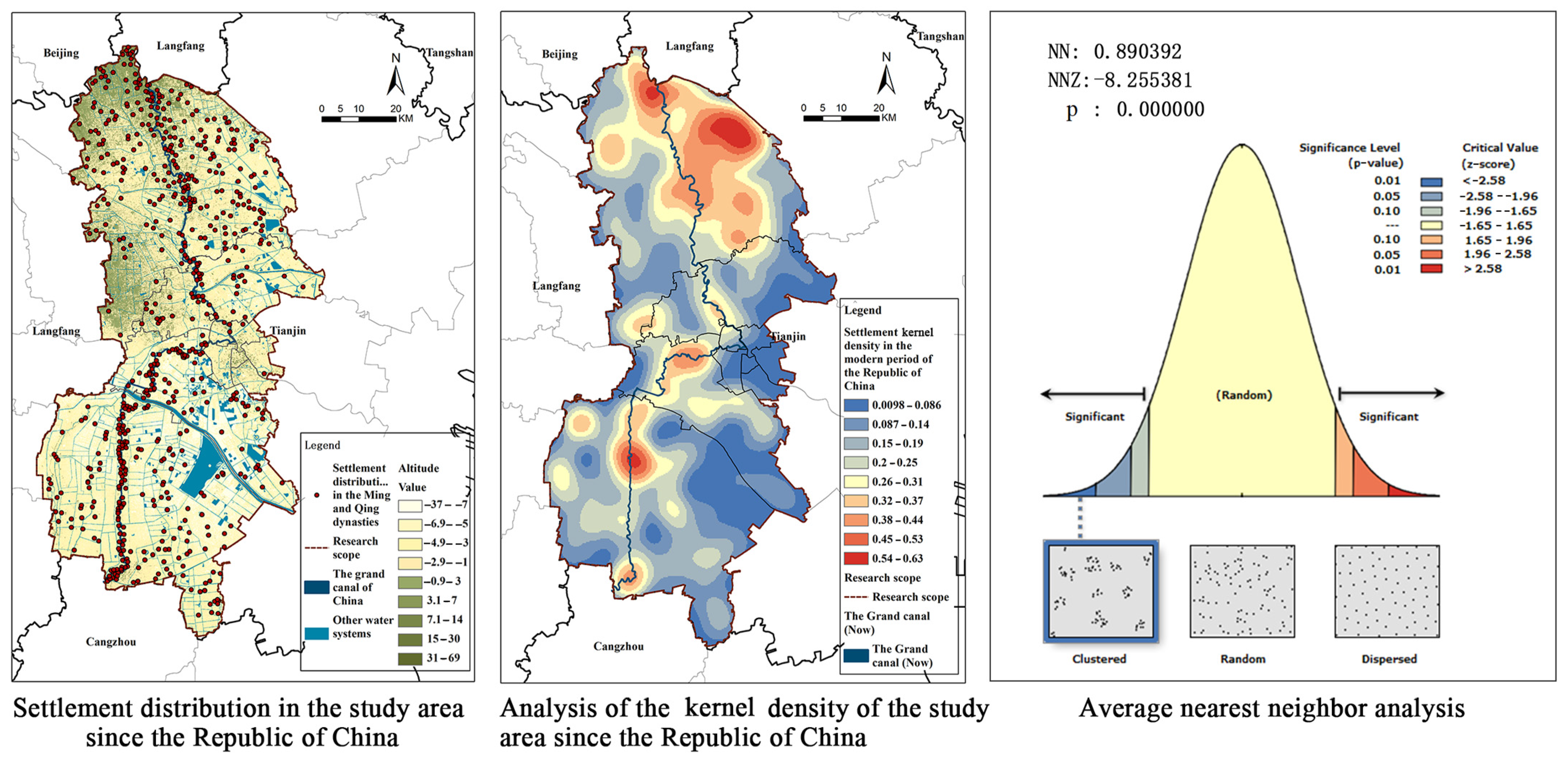
There are altogether 1550 settlements since the era of the Republic of China in the survey region. As the kernel density analysis indicates, the settlements in northern Wuqing District and on both banks of the South Canal and the North Canal boast fairly conspicuous characteristics (Figure 18). The high-value area in Wuqing District chiefly is composed of Hebeitun Town, Cuihuangkou Town, Xiawuqi Town, Damengzhuang Town, Daliang Town, Nancaicun Town, Daxianchang Town, Xuguantun Town and Yangcun Street adjacent to the canal and the surrounding Chengguan Town, Caozili Town and Meichang Town. The high-value area in Beichen District primarily consists of Shuangjie Town, Beicang Town, Tianmu Town and surrounding Wangqingtuo Town and Shuangkou Town along the canal. The high-value area in Xiqing District is composed of Zhongbei Town, Yangliuqing Town, Xinkou Town and surrounding Zhangjiawo Town and Jingwu Town along the canal. The high-value area in Jinghai District consists of Liangwangzhuang Town, Duliu Town, Jinghai Town, Shuangtang Town, Chenguantun Town and Tangguantun Town adjacent to the canal and surrounding Taitou Town, Wangkou Town, Ziya Town, Daqiuzhuang Town and Caigongzhuang Town. The average nearest-neighbor analysis result indicates that the nearest-neighbor rate is 0.89, the z score is −8.26 and the cultural relics in the settlements along the canal in the transformation period in the survey region are in “multi-kernel + one-belt + splattering” distribution.

4. Discussion: In-Situ Evolution Rules of the Settlement Space along the Grand Canal Tianjin Section

4.1. Comparative Analysis of In-Situ Spatial-Temporal Evolution of the Settlement Space along the Grand Canal Tianjin Section

The influencing factors of settlement formation and distribution have undergone the process from single factor to multiple factors and from focusing on the nature to comprehensively considering the social, economic and natural factors [40,41], gradually extending to the fields of humanities and social sciences, government policies [42], population migration [43], rural traffic [44], population density and social culture [45]. Huo X.L. et al. (2021) hold the view in their research that the natural, social and economic factors are the main factors influencing the evolution of the settlement space along the Grand Canal Tianjin Section [7]. From the perspective of cultural heritage, the present paper comprehensively analyzes the characteristics of cultural heritage and settlement distribution of the settlement space along the canal in different historical periods and explores the influencing factors of the in-situ evolution of the settlement space along the canal from the perspectives of the nature, projects, systems, policies, economy and culture via comparative analysis of the in-situ spatial-temporal evolution.

4.1.1. Comparison of the Numbers of Cultural Relics and Settlements

Comparison of the numbers of cultural relics and settlements along the Grand Canal Tianjin Section in different stages of evolution can help us with a macro understanding of the tendency of change (Figure 19). As the change of the number of cultural relics manifests, the cultural relics in the survey region feature a great variety and a great amount. The cultural relics of different periods total 960. In the pre-canal period, the cultural relics grossed 76 and accounted for 7.92% of the total, including only four of the primitive society (the Neolithic Age—the Xia, Shang and Zhou Dynasties), 28 of the Warring States period and 44 of the Han Dynasty. There were only nine cultural relics of the settlements along the canal in the rudimentary period, taking up 0.94% of the total. The number in the development period rapidly rose to 144, that is, 15% of the total, including 56 of the Song and Liao Dynasties (including the new increase), 22 of the Jin Dynasty (including the new increase) and 97 of the Yuan Dynasty (including the new increase). The figure in the mature period amounted to 290, that is, 30.21% of the total, including 104 of the Ming Dynasty (including the new increase) and 225 of the Qing Dynasty (including the new increase). The number in the transformation period jumped rapidly to 441, accounting for 45.94% of the total. The amount of settlements changed from 69 in the pre-canal period to 13 in the rudimentary period, 89 in the development period, 630 in the mature period and rapidly 1550 in the transformation period. The evolution tendency line analysis indicates that the numbers of settlements and cultural relics along the Grand Canal Tianjin Section display a tendency of rapid rise. The R2 of the tendency of cultural relics is 0.98, and that of the settlements is 0.89, demonstrating good imitative effects and a very explicit uptrend of index.

4.1.2. Comparison of the Correlation between Settlement Distribution and the Canal

ArcGIS10.2 divides the buffers of the ancient river courses and canals of the Sui, Tang and Yuan Dynasties and the canal system in modern Tianjin, sets the distance of the buffers to be 0.5 KM, 2 KM, 5 KM, 7.5 KM and 10 KM and calculates the numbers of the settlements and cultural relics in different buffers and the proportions [46]. Considering the evolutionary process of the Grand Canal Tianjin Section, it calculates the numbers of the ancient river courses and canals in the buffers in the Sui and Tang Dynasties in the pre-canal period and the rudimentary period, those of the ancient canals in the Yuan Dynasty in the development period and the present buffers of the water system in the mature and transformation periods of the settlements along the canal.
Finally, the buffer analysis manifests (Table 2): in the pre-canal period, 64.47% of the cultural relics were distributed within 7.5 KM of the ancient river courses, 10.53% in the buffer of 10 KM of the ancient river courses and 25% out of the buffer. A total of 66.67% of the settlements were distributed in the buffer of the ancient river courses within 7.5 KM, 10.15% in the buffer of 10 KM of the ancient river courses and 23.19% out of the buffer. In the rudimentary period, 44.44% of the cultural relics were distributed within 7.5 KM of the ancient channels and river courses, 33.33% in the buffer of 10 KM of the ancient river courses and 22.22% out of the buffer. A total of 69.23% of the settlements were distributed within 7.5 KM of the ancient channels and river courses, 7.69% in the buffer of 10 KM of the ancient river courses and 23.08% out of the buffer. In the development period, 64.16% of the cultural relics were distributed in the buffer of the ancient river courses within 7.5 KM, 6.92% in the buffer of 10 KM of the ancient river courses and 28.93% out of the buffer. A total of 60.66% of the settlements were distributed in the buffer of the ancient river courses within 7.5 KM, 6.74% in the buffer of 10 KM of the ancient river courses and 32.58% out of the buffer. In the mature period, 91.04% of the cultural relics were distributed in the buffer of the ancient river courses within 7.5 KM, 4.83% in the buffer of 10 KM of the ancient river courses and 4.14% out of the buffer. A total of 55.24% of the settlements were distributed in the buffer of the ancient river courses within 7.5 KM, 8.89% in the buffer of 10 KM of the ancient river courses and 35.87% out of the buffer. In the transformation period, 95.24% of the cultural relics were distributed in the buffer of the ancient river courses within 7.5 KM, 0.91% in the buffer of 10 KM of the ancient river courses and 3.86% out of the buffer. A total of 43% of the settlements distributed in the buffer of the ancient river courses within 7.5 KM, 9.55% in the buffer of 10 KM of the ancient river courses and 46.66% out of the buffer. As the data comparison shows, the distribution of the cultural relics in the mature and transformation periods was closer to the buffer within 7.5 KM of the canal river system than in other periods; the sites of settlements in the pre-canal, mature and development periods were closer to the buffer of 7.5 KM of the ancient channels and river courses; the sites of settlements in the transformation period of the canal were farther to the canal river system. In brief, the canal settlements more correlated with cultural relics can be further selected by comparatively analyzing the cultural relics, settlements and river system buffer along the canal.

4.1.3. Comparison of Spatial Distribution and Focus Transfer

The standard deviational ellipse analytical method and the average center analytical method based on ArcGIS made quantitative analysis of the data of the cultural relics and settlements along the canal in different historical periods to probe into the rules of spatial distribution and focus transfer of the settlements along the canal (Figure 20). As to the cultural relics, the spatial distribution in the pre-canal period, rudimentary period and the development period was similar. The elliptical space in the long and narrow shape from south to north is distributed in the present canal by west. The focus of the distribution of the cultural relics was transferred to the central urban area in the mature period and completely lay in the central urban area in the transformation period, with the spatial distribution in the long and narrow elliptical shape from west to south. As to the settlement space, the shapes of the spatial distribution in different stages are close, all in an elliptical distribution of the South Canal and the North Canal. The focus of space is concentrated to the west of the present canal.
The comparison of the generated area index shows that the generated area of the settlement space is slightly larger than that of cultural relics in different periods; the area of the cultural relics in different periods in comparison indicates that it is the largest in the pre-canal period and the smallest in the mature period; the area index of the cultural relics is in the descending order of the pre-canal period, the rudimentary period, the transformation period, the development period and the mature period; the area of the settlement space in different periods in comparison indicates that it is the largest in the rudimentary period and the smallest in the mature period. The area of the settlement space is in the descending order of the rudimentary period, the pre-canal period, the development period, the transformation period and the mature period. As the flattening index displays, the flattening difference of cultural relics is the largest while that of the settlement space is the smallest; the flattening index of cultural relics in different periods in comparison shows that it is the largest at 155.95 in the transformation period, 7.37 in the mature period, 1.72 in the pre-canal period, 0.95 in the development period and 0.12 in the rudimentary period, the largest in the transformation period and the smallest in the rudimentary period; it is the smallest in the mature period; the flattening of the settlement space in different periods in comparison displays that it is in the descending order of 7.46 in the rudimentary period, 4.61 in the development period, 4.53 in the transformation period, 3.43 in the mature period and 1.02 in the pre-canal period, the largest in the rudimentary period and the smallest in the pre-canal period. Generally speaking, the spatial distribution and focus transfer of the cultural relics have conspicuously the rules of transfer from the area surrounding the downtown to the city center.

4.2. Factors Influencing the Spatial-Temporal Evolution of the Settlement Space along the Grand Canal Tianjin Section

Based on quantities of historical literature and field survey, this paper tries to bring forth the factors influencing the in-situ spatial-temporal evolution of the Grand Canal Tianjin Section from the perspectives of nature, projects, policies, systems, economy and culture. This research spots that the unique natural and geological environment is the locational factor fostering the settlements, the magnificent grain transportation projects were the decisive factor for the establishment of the settlements along the canal, the rigorous grain transportation management system was the factor guaranteeing the evolution of settlements, the grain growing and military defense policies of all historical periods were the factors of change of the reproduction of the settlements, the prosperous agricultural, commercial and economic growths were success factors for settlement development and the diverse migration and folk culture were a vitality factor for settlement evolution.

4.2.1. Locational Factors: The Unique Natural Geographical Environment

The previous analysis exhibits that the survey region is generally in a low-lying, gentle terrain and is prone to the sea level. Therefore, in the pre-canal period, transgression generated severe destruction to the cultural development of the settlements and consequently the numbers of cultural relics and settlements from the Eastern Han Dynasty to the rudimentary period when the settlements along the canal drastically dropped. After the digging of the Pinglu Canal, the Haihe river system was gradually formed. The five trunk streams of the South Canal, the North Canal, the Ziya River, the Daqing River and the Yongding River converged at the Sancha River Estuary in the city and flew into the Haihe River and finally eastward into the sea. Tianjin became the hub of the river and sea transportation on the North China Plain and the aquatic portal to the capital city of Beijing. Advantageous geographical conditions fostered the settlement and reproduction of the residents in the canal area. Numerous settlements got their names from the natural features, especially the hydrological characteristics, for instance, tan (beach), tang (pond), wa (depression), kou (estuary), zui (mouth) and gu, such as Dazhigu, Xigu, Dahetan, Xiaohetan, Lizui, Pangzui, Dongniantuozui, Xiniantuozui, Dakouzimen and Xiaokouzimen. The unique natural and geological environment fostered numerous settlements following the “terrain of the river courses” along the canal.

4.2.2. Determinants: Construction of the Grandiose Grain Transportation Project

Grain transportation was a behavior for grain consumption, military needs and watercourse transportation in the capital city in ancient China. After the Yuan Dynasty unified China, the grain transportation project became more prominent; the development of sea transportation expanded the traffic volume of grain transportation, and Tianjin became a place of strategic importance. The Sancha River Estuary, Yangcun Town and Beicang Town along the North Canal became important imperial granaries [47]. In the Ming Dynasty, the grain transportation project grew increasingly mature; the Grand Canal was connected, became a commercial route for grain transportation from south to north and stepped up the economic and cultural exchanges between southern and northern China. The settlements on both banks of the canal and around developed and expanded. The Grand Canal became the economic lifeline linking southern and northern China in the Qing Dynasty. Apart from grain transportation, plentiful local special products, silk and building materials were transported via the canal. Tianjin became the important central terminal station and the largest commodity distributing center in North China. Numerous settlements got their names from the wharves, granaries and facilities, for instance, Beicang Town, Shangcang Town, Xiacang Town, Cang’ao Street, Dongxicang Village and Hexiwu Town. Such settlements as Yangcun, Duliu, Jinghai, Tangguantun and Shuangtang were all names of important wharves, featuring a dense population and advanced economy. The magnificent grain transportation projects fostered the settlements of “ferry & wharf types” and “warehouse type” for grain transportation.

4.2.3. Guarantee Factors: Strict Grain Transportation Management System

A strictly graded grain transportation management system was implemented in Tianjin in the Ming and Qing Dynasties. The managing officials principally included high-ranking officials and officials of the prefectures, states and counties. High-ranking officials were not included in the authorized size of the government body in the early Ming Dynasty. It was in the middle Ming Dynasty that the officials in charge of the canal were included in the authorized size of the government body. An official of the Ministry of Works in feudal China was in charge of the river course [47]. In the Qing Dynasty, high-ranking officials in charge of grain transportation were chiefly called Censor of Grain Transportation. Different censors of grain transportation were in charge of the South Canal and the North Canal in different places in different periods. Many positions of military officials were set besides the grassroots officials, for instance, Head of Sanliqian Village, Head of Wangjiawu Village and Head of Kuangergang. In the Ming and Qing Dynasties, apart from the officials specially in charge of grain transportation, plentiful organizations in charge of dredging silt (called “qianpu”) and servants were set along the canal for specific canal maintenance. These organizations scattered in the settlements and the servants were composed of the residents and soldiers on both banks of the canal. There are many qianpus in the settlements along the North Canal, like Dasanliqian, Xiaosanliqian, Mengcun, Baimiao, Laomidian, Dingzigu, Yangcun Town, Nancaicun Town, Beicaicun Town and Yinerwan Town; there are also qianpus in the settlements along the South Canal, including Xiaozhigu Town, Yangliuqing Town, Shawo Town, Duliu Town, Diaotai Town, Xinkou Town, Shaozhikou Town and Zaicheng Town. The strict management system further accelerated the development of the settlements along the canal. The rigorous grain transportation management system further stimulated the reproduction and development of the settlements along the canal and the formation of the settlements to “dig and dredge canals for irrigation” for grain transportation.

4.2.4. Change Factors: The Policies on Opening Up Wasteland and Growing Food for Military Defense in Successive Dynasties

Since its rise, the central dynasties would set up transport teams of some scale to guarantee grain transportation. From the grain transportation men in the Han Dynasty, the serving civil households in the Sui and Tang Dynasties and the professional transportation army in the Northern Song Dynasty to the transportation army after Beijing was chosen for the capital in the Ming Dynasty, the army assumed a large part of transportation [48]. In the Ming Dynasty, the transportation army was established on the basis of the military defense institutions, and the militia households were hereditary and chiefly responsible for grain transportation and agricultural production. To guarantee military needs and replenish soldiers’ pay and provisions, opening up wasteland and growing grain became the basic state policy. During the confrontation of the Song and Liao Dynasties, after Emperor Taizong of Song failed in conquering the Liao Dynasty, he ordered to repair and cement the city walls and moats along the border, open up wasteland and grow grain to replenish the granaries, for instance, Duliu Fortress, Dangcheng Fortress, Shawo Fortress and Baiwanwo Fortress along the South Canal in the survey region. In the early Yuan Dynasty, to solve the problems of population die-off, economic depression and inadequate military provisions resulting from wars, the system of reclamation of wasteland by army units was implemented with each army official in charge of 1000 or 100 households. Since the settlements set by the policy had the characteristics of “being written into household register”, the titles of the settlements had the wording of “千户 (‘qianhu”, meaning 1000 households)”, “百户 (‘baihu’, meaning 100 households)” and “官 (‘guan’, meaning official)”. In the Ming Dynasty, to consolidate political power, reclamation of wasteland by army units was implemented while relocating the population. In 1404, 20% of the garrison army guarded for defense while 80% grew grain; 30% of the frontier garrison army guarded for defense while 70% grew grain. For example, such settlements as Xiaoshibaihu, Erbaihu, Sanbaihu, Liubaihu, Babaihu, Jiubaihu, Dashibaihu, Wangqianhu, Liqianhu, Wangguantun, Chenguantun and Gaoguantun got their titles therefrom. The grain growing and military defense policies of all historical periods fostered quantities of settlements to “station troops” along the canal.

4.2.5. Success Factors: Prosperous Agricultural and Commercial Economy

During the confrontation between the Song and Liao Dynasties, the war in Tianjin at the border of the two states frequently broke out. After the “Chanyuan Treaty” was signed, the relations of the two states were relatively stable. They began to have economic transactions at the sites for frontier trade. The commodities of Song were primarily tea, silk and hemp articles, grain, spice and chinaware while those of Liao were chiefly livestock, fur and feather, harnesses and salt. With the development of grain transportation in the Jin and Yuan Dynasties, the commerce on both banks of the Grand Canal Tianjin Section gradually thrived, for example, Beicang, Nancang, Baimiao and Shangpukou that were bustling settlements along the canal. With the connection and development of the Grand Canal of China in the Ming and Qing Dynasties, the economy of the settlements along the canal saw rapid development; craft workshops gradually increased; employment relationship developed; commercial capital turned more dynamic; the settlements along the Tianjin Section remarkably changed in terms of amount, scale, type and function, and the industrial and commercial development gathered speed. These settlements became representative towns of taxation along the canal. Hexiwu Town along the North Canal developed to be a famous tax office levying commercial tax. Laomidian Village and Tiaoliangwu Village were grain hoarding and trading venues; Muchang Town stored wood commodities; Taokou Village and Beicang Town were the earlier market fairs and market towns; Yangliuqing Town boasted superior handicraft articles and broker houses specially on some trade appeared along the canal, expediting settlement development. The prosperous agricultural and commercial economy quickened the continuous development of the settlements along the canal and the formation of the settlements for “commercial and trade exchanges”, “water transport and fishery”, “vegetable planting” and “processing industry”.

4.2.6. Vitality Factors: Diverse Migration and Folk Cultures

Nonlocal migrants gradually became the mainstream residents in Tianjin for the demands of canal opening, grain growing and military defense. According to The History of the Yuan Dynasty, after the Yuan Dynasty relocated its capital, Tianjin became a pivotal hub of grain transportation; the imperial court had troops stationed there for years on end; civilians and soldiers lived there together, and the nonlocal population exceeded that of local residents. According to historical data, the people in ancient Tianjin had twice important migration in the Ming and Qing Dynasties. The first was in 1404 when a garrison was set for defense; quantities of officials and soldiers together with their families settled in Tianjin and became important parts of Tianjin’s population [49]. According to the official statistics in Tianjin in the Ming Dynasty [50], its people came from 160 prefectures and counties of the 17 provinces nationwide. Among them, the migrants were chiefly from Anhui, Jiangsu, Beijing and Hebei, respectively, accounting for 28.5%, 18.3%, 12.9% and 10.5%. The second was during the reign of Emperor Kangxi and Emperor Qianlong of the Qing Dynasty, when, with the prosperity of business, large quantities of nonlocal migrants settled there. According to the records, the migrants in the Qing Dynasty came from about 10 provinces nationwide, mostly in the south of the lower reaches of the Yangtze River that accounted for 53%. Different from the forced migrants of the Ming Dynasty, the migrants of the Qing Dynasty migrated freely. It indicates the economic prosperity of Tianjin in the Qing Dynasty which spurred on population flow.
Under the influence of diverse migration culture, the settlements along the Grand Canal Tianjin Section have developed folk culture of diverse types and styles. In the survey region, there are 189 intangible cultural heritage sites of such five categories as oral tradition and pattern of manifestation, traditional performance art, folk customs, traditional knowledge and practice of dwellings and traditional handcraft skills (Figure A3). As to spatial distribution, the national resources are chiefly distributed in the city center, and there are only four national heritage resources in Beichen District, Xiqing District and Wuqing District along the canal, namely, Liuyuan Music Playing, Fragrant Pagoda Music Playing, Li-style Shadowboxing and Yangliuqing Plank New Year Pictures. There are altogether 58 city-level intangible cultural heritage sites in Wuqing District, Beichen District, Xiqing District and Jinghai District along the canal in addition to the central area. These intangible cultural heritage sites have become significant resources for the inheritance and development of the settlement space along the canal. Diverse migration and folk culture took deep roots in the settlements along the canal and fostered the settlements featuring such folk customs as “traditional performance”, “traditional handicrafts” and “oral traditions”.

5. Conclusions and Prospects

The spatial-temporal evolution of the settlement space along the Grand Canal Tianjin Section went through five historical periods. In the pre-canal period, cultural relics display “random” and “aggregate” distribution; settlement development was drastically influenced by natural landforms and displayed the “multi-kernel” model development along the South and North Canals. In the rudimentary period, the cultural relics of the settlements along the South and North Canals were still in random “multi-point + disperse” distribution. In the development period, the number of cultural relics along the canal increased. The cultural relics and settlements were in “belt + multi-kernel” distribution along the canal. In the mature period, the cultural relics of the Ming and Qing Dynasties had some differences. The cultural relics of the Ming Dynasty were in “belt + multi-kernel” distribution along the canal. As Tianjin’s economy rapidly developed in the Qing Dynasty, cultural relics in the city center sharply increased in number in “uni-kernel + one belt + multi-point” distribution with the Sancha River Estuary as the center along the canal. The settlements matured during the Ming and Qing Dynasties and spread to both banks of the South and North Canals in “stripe + multi-kernel + splattering” spatial distribution. With the decline of the function of the canal during the transformation period, settlement evolution in the survey region was also affected by the economic and social growth of the central city. In that period, cultural relics were chiefly distributed in the “uni-kernel + multi-point” pattern in the city center but rarely surrounding the canal. As to settlement development, the number of settlements noticeably increased, and the northern part of the survey region displayed obvious characteristics and the “multi-kernel + one belt + splattering” distribution model.
Based on the HGIS analytical method, this paper establishes the methods and paths of the in-situ spatial-temporal evolution of the settlement space along the canal, applies the kernel density estimation method, the average nearest-neighbor analytical method, the standard deviational ellipse analytical method and the average center analytical method and interprets the spatial-temporal evolution rules of the settlement space along the canal. It helps clarify the history of the development process of the settlement space along the canal and more visually reflects the cultural relics and settlement distribution along the canal in different historical periods. The present research provides the implementation method for the spatial-temporal evolution of the settlements along other sections of the Grand Canal of China. The research results are good for further enriching the cultural relics resources along the canal, clarifying the important value of the settlement relics in the cultural heritage along the canal and providing basis and data support for the overall space planning and management of the cultural relics along the Grand Canal of China. Follow-up research should, according to the cultural relics and settlement distribution rules along the canal, profoundly analyze the in-situ types and characteristics of the settlement space along the canal, further demarcate the boundary of the settlements along the Grand Canal Tianjin Section and accelerate the conservation and utilization of the settlements and the inheritance and development of the traditional culture along the Grand Canal of China.

Author Contributions

Conceptualization, Y.Z. and G.B.; methodology, Y.Z. and G.B.; software, Y.Z.; validation, T.S., G.B. and J.Y.; formal analysis, T.S. and G.B.; investigation, Y.Z., T.S. and G.B.; resources, Y.Z. and T.S.; data curation, G.B.; writing—original draft preparation, Y.Z.; writing—review and editing, G.B.; visualization, Y.Z. and G.B.; supervision, J.Y.; project administration, Y.Z.; funding acquisition, Y.Z. All authors have read and agreed to the published version of the manuscript.

Funding

This research was funded by The Humanities and Social Sciences Project of the Ministry of Education: “The In-situ Spatial-temporal Characteristics and Inheritance Path of the Settlement Space along the Grand Canal Tianjin Section”, grant number 22YJC760135.

Data Availability Statement

Data derived from the current study can be provided to the readers based upon their explicit request.

Acknowledgments

This paper was financially supported by The Humanities and Social Sciences Project of the Ministry of Education (22YJC760135).

Conflicts of Interest

The authors declare no conflict of interest.

Appendix A

Table A1. Summary table of settlement cultural relics along the Grand Canal Tianjin section.
Evolution StagesAncient ArchitecturesAncient TombsAncient SitesHistorical Remains of Irrigation WorksRiver CoursesInscriptionsImportant Historical Relics and Representative Architectures in Modern TimesNumber
The pre-canal periodThe Neolithic Age00400004
The Xia, Shang and Zhou Dynasties
The Warring States period0622000028
The Han Dynasty01529000044
The rudimentary periodThe Wei Dynasty03600009
The Sui and Tang Dynasties
The development periodThe Song and Liao Dynasties01340111056
The Jin Dynasty2114140022
The Yuan Dynasty1483720097
The mature periodThe Ming Dynasty918652370104
The Qing Dynasty331746823881225
Period of transitional developmentSince the Republic of China110307429441
Summary quantity4654248221253510945
Figure A1. Distribution of the settlements along the Grand Canal Tianjin section.
Land 12 01023 g0a1
Figure A2. Distribution of settlement cultural relics along the Grand Canal Tianjin section.
Land 12 01023 g0a2
Figure A3. Distribution of intangible heritage along the Grand Canal Tianjin section.
Land 12 01023 g0a3

References

  1. Wang, Y. Management of the Grand Canal and it’s bid as a world cultural heritage site. Front. Arch. Res. 2012, 1, 34–39. [Google Scholar] [CrossRef]
  2. Wei, Q. Negotiation of Social Values in the World Heritage Listing Process: A Case Study on the Beijing-Hangzhou Grand Canal, China. Archaeologies 2018, 14, 501–526. [Google Scholar] [CrossRef]
  3. Fu, C.L. The History of Urban Development along the Grand Canal of China; Sichuan People’s Publishing House: Chengdu, China, 1985. [Google Scholar]
  4. Chen, W. On the Line along the Grand Canal of China: Research on the Historic Cities and Architectures along the Grand Canal of China; China Architecture & Building Press: Beijing, China, 2013. [Google Scholar]
  5. Cheng, Z.F.; Tang, S.Y.; Hua, H.L. A Study of Cognition and Identification of the Grand Canal Culture from the Perspective of Traditional Village Residents in Beijing: The Cases of Three Traditional Villages in Tongzhou. J. Beijing Union Univ. 2018, 16, 36–46. [Google Scholar]
  6. Li, Y.; Sun, T.; Hua, G. Research on the Generation and Distribution Rules of the Cultural Relics in the Settlements along the Grand Canal of China. Jiangsu Soc. Sci. 2021, 42, 182–193. [Google Scholar]
  7. Huo, X.; Xu, X.; Tang, Y.; Zhang, Z. An analysis of the spatial evolution and influencing factors of rural settlements along the Shandong section of the Grand Canal of China. River Res. Appl. 2021, 20, 1–17. [Google Scholar] [CrossRef]
  8. Zhao, Y.; Zeng, J. Study on the Development of Ecological Space Adaptability of Water Environment Based on the Perspec-tive of Landscape Pattern Optimization—Take Taierzhuang Ancient Town along the Grand Canal as an Example. Chin. Landsc. Archit. 2021, 37, 62–67. [Google Scholar]
  9. UNESCO. Convention Concerning the Protection of the World Cultural and Natural Heritage; UNESCO: Paris, France, 1972; Available online: https://whc.unesco.org/archive/convention-ch.pdf (accessed on 30 April 2023).
  10. UNESCO. Operational Guidelines for the Implementation of the World Heritage Convention; UNESCO: Paris, France, 2021; Available online: http://whc.unesco.org/en/guidelines (accessed on 30 April 2023).
  11. World Heritage Committee. Information Document On Heritage Canals. WHC-94/CONF. 033/INF. 10, Paris, 31. 10, 1994. Available online: http://whc.unesco.org/archive/canals94.htm (accessed on 30 April 2023).
  12. Labadi, S.; Giliberto, F.; Rosetti, I.; Shetabi, L.; Yildirim, E. Heritage and the Sustainable Development Goals: Policy Guidance for Heritage and Development actors. ICOMOS, 2021. Available online: https://openarchive.icomos.org/id/eprint/2453/7/ICOMOS_SDGPG_2022.pdf (accessed on 3 May 2023).
  13. Caballero, G.; Colvile, B.; Perez-Alvaro, E.; Dharshini, S. Intersection of Heritage, Water, and the Work of the ICOMOS Sustainable Development Goals Working Group. Blue Pap. 2023, 2, 84–95. [Google Scholar] [CrossRef]
  14. Price, A.G. White Settlement in the Panama Canal Zone. Geogr. Rev. 1935, 25, 1–11. [Google Scholar] [CrossRef]
  15. Conzen, M.P. Heritage corridors and the new historic canal tourism in the United States. Geogr. Rundsch. 2001, 53, 49–55. [Google Scholar]
  16. Garcia-Mayor, C.; Martínez, G.C. Poly-nuclear urban system, landscape identity and economic development: The Vega Baja of the Segura River (Alicante) case study. In Proceedings of the 24th ISUF 2017—City and Territory in the Globalization Age, Valencia, Spain, 27–29 September 2017. [Google Scholar]
  17. Lavoie, C.; Sleipness, O.R. Fluid Memory: Collective Memory and the Mormon Canal System of Cache Valley, Utah. Landsc. J. 2018, 37, 79–99. [Google Scholar] [CrossRef]
  18. Biscaya, S.; Elkadi, H. A smart ecological urban corridor for the Manchester Ship Canal. Cities 2021, 110, 103042. [Google Scholar] [CrossRef]
  19. Flemsæter, F.; Stokowski, P.; Frisvoll, S. The rhythms of canal tourism: Synchronizing the host-visitor interface. J. Rural. Stud. 2020, 78, 199–210. [Google Scholar] [CrossRef]
  20. Li, J.; Zhang, H.; Sun, Z. Spatiotemporal variations of land urbanization and socioeconomic benefits in a typical sample zone: A case study of the Beijing-Hangzhou Grand Canal. Appl. Geogr. 2020, 117, 102187. [Google Scholar] [CrossRef]
  21. Tang, F.; Wang, L.; Guo, Y. Spatio-temporal variation and coupling coordination relationship between urbanization and habitat quality in the Grand Canal, China. Land Use Policy 2022, 117, 106119. [Google Scholar] [CrossRef]
  22. Wang, F.; Hu, W.; Gao, C. The Coupling and Evolution of Water and Land Transportation Network and Urban Settlements along the Grand Canal from the Perspective of Resilience. Landsc. Archit. 2021, 28, 31–38. [Google Scholar]
  23. Rong, Q.; Wang, J. Interpreting heritage canals from the perspective of historical events: A case study of the Hangzhou sec-tion of the Grand Canal, China. J. Asian Archit. Build. Eng. 2021, 20, 260–271. [Google Scholar] [CrossRef]
  24. Jin, X.; Wang, J. Assessing Linear Urban Landscape from dynamic visual perception based on urban morphology. Front. Arch. Res. 2021, 10, 202–219. [Google Scholar] [CrossRef]
  25. Zhao, Y.; Yan, J.; Huang, M.; Bian, G.; Du, Y. Analysis of Settlement Space Environment along China’s Grand Canal Tianjin Section Based on Structural Equation Model—Case Study of 44 Typical Settlements. Sustainability 2022, 14, 5369. [Google Scholar] [CrossRef]
  26. Zhao, Y.; Yan, J.W.; Li, Y.; Bian, G.M.; Du, Y.Z. In-Site Phenotype of the Settlement Space along China’s Grand Canal Tianjin Section: GIS-sDNA-Based Model Analysis. Buildings 2022, 12, 394. [Google Scholar] [CrossRef]
  27. Dhanaraj, K.; Angadi, D.P. A GIS based interpretation of the historical evolution of urban settlements in Mangalore City, India. Spat. Inf. Res. 2020, 29, 615–629. [Google Scholar] [CrossRef]
  28. Li, F.; Zhu, H. The Application of GIS to the Study and Cultural Geography--Commentary on the Research Progress abroad. Hum. Geogr. 2009, 24, 41–47. [Google Scholar]
  29. Gregory, I.; Kemp, K.K.; Mostern, R. Geographical information and historical research: Current progress and future directions. Hist. Comput. 2001, 13, 7–23. [Google Scholar] [CrossRef]
  30. Li, F. Application and Perspective of GIS in Research on Historical Geography and Cultural Geography. Geogr. Geo-Inf. Sci. 2008, 24, 21–26. [Google Scholar]
  31. Pan, W.; Wang, Z.; Man, Z. The Overview for the Information of Historical Geography, 2000–2019. J. Chin. Hist. Geogr. 2020, 35, 25–35. [Google Scholar]
  32. Pan, W.; Sun, T.; Man, Z. The Review of GIS entered into Chinese Historical Geography since 2000 and Outlook. J. Chin. Hist. Geogr. 2012, 27, 11–17. [Google Scholar]
  33. Trepal, D.; Lafreniere, D.; Gilliland, J. Historical Spatial-Data Infrastructures for Archaeology: Towards a Spatiotemporal Big-Data Approach to Studying the Postindustrial City. Hist. Archaeol. 2020, 54, 424–452. [Google Scholar] [CrossRef]
  34. Xi, X.; Qin, J.; Yu, K. Application of Historic Map and Spatial Information Technology in the Identification of the Grand Canal: A Case Study of Qingkou Hing in Huai’an, Jiangsu Province. Areal Res. Dev. 2010, 29, 123–131. [Google Scholar]
  35. Han, J.G. Trace to the Ancient History of Tianjin; Tianjin Ancient Books Publishing House: Tianjin, China, 2006. [Google Scholar]
  36. Compilation Team of Ancient Architecture of Tianjin. Ancient Architecture of Tianjin; Tianjin Science and Technology Publishing House: Tianjin, China, 1989. [Google Scholar]
  37. Guo, Y.J. History of Urban Development of Ancient Tianjin; Tianjin Ancient Books Publishing House: Tianjin, China, 1989. [Google Scholar]
  38. Hua, X.R.; Liu, Y.Z. Investigation and Textual Research on the Ancient Site of Xidiaotai Town in Jinghai County. Tianjin Soc. Sci. 1983, 3, 92–95. [Google Scholar]
  39. Ren, J.D. From Villages to Towns: Analysis of the Urban and Rural Systems of Modern Tianjin. Probe 2014, 34, 151–155. [Google Scholar]
  40. Hoskins, W.G. The Making of the English Landscape; Hodder & Stoughton: London, UK, 1955; pp. 58–72. [Google Scholar]
  41. Peter, S.R. Implication of rural settlement patterns for development: A historical case study in Qaukeni, Eastern Cape, South Africa. Dev. S. Afr. 2003, 20, 405–421. [Google Scholar]
  42. Hoffman, G.W. Transformation of Rural Settlement in Bulgaria. Geogr. Rev. 1964, 54, 45. [Google Scholar] [CrossRef]
  43. Hall, D. Albania: Rural development, migration and uncertainty. Geojournal 1996, 38, 185–189. [Google Scholar] [CrossRef]
  44. Andrew, G. An Introduction to Rural Geography; Edward Amold: London, UK, 1985; pp. 20–40. [Google Scholar]
  45. Diane, K.M.L.; Stokes, C.S.; Atsuko, N. Residence and income inequality: Effects on mortality among U.S. counties. Rural. Sociol. 2001, 66, 579–598. [Google Scholar]
  46. Zhou, T.; Cui, J. Spatiotemporal distribution and driving force of settlements from Yangshao to Shang-Zhou periods in Guangzhou area based on GIS. J. Earth Environ. 2022, 13, 163–175. [Google Scholar]
  47. Li, J. Research on Grain Transportation in Tianjin. Ph.D. Thesis, Nankai University, Tianjin, China, 2009. [Google Scholar]
  48. Chen, F. The Transportation Army in the Ming Dynasty. Acad. J. Zhongzhou 1997, 19, 119–122. [Google Scholar]
  49. Yang, D.X. Tianjin is a City of Migration. Tianjin People’s Congr. 2017, 15, 45–46. [Google Scholar]
  50. Luo, S.W. Urban History of Modern Tianjin; China Social Sciences Press: Tianjin, China, 1993. [Google Scholar]
Figure 1. Survey region.
Land 12 01023 g001
Figure 2. Research route of in-situ spatial-temporal evolution of the settlement space along the canal.
Land 12 01023 g002
Figure 3. Sequence of the evolution stages of the settlements along the canal.
Land 12 01023 g003
Figure 4. Distribution of the river system in the pre-canal period.
Land 12 01023 g004
Figure 5. Summary of distribution characteristics of cultural relics in the pre-canal period.
Land 12 01023 g005
Figure 6. Summary of the settlement distribution characteristics in the pre-canal period.
Land 12 01023 g006
Figure 7. Distribution of the canal river system in the rudimentary period.
Land 12 01023 g007
Figure 8. Summary of distribution characteristics of cultural relics in the rudimentary period.
Land 12 01023 g008
Figure 9. Summary of the settlement distribution characteristics in the rudimentary period.
Land 12 01023 g009
Figure 10. Distribution of the canal river system in the development period.
Land 12 01023 g010
Figure 11. Summary of cultural relics analysis of the settlements along the canal in the development period.
Land 12 01023 g011
Figure 12. Summary of settlement distribution characteristics in the development stage.
Land 12 01023 g012
Figure 13. Distribution of the canal river system in the mature period.
Land 12 01023 g013
Figure 14. Summary of distribution characteristics of cultural relics in the mature period.
Land 12 01023 g014
Figure 15. Summary of settlement distribution characteristics in the mature period.
Land 12 01023 g015
Figure 16. Distribution of the canal system in the transformation period.
Land 12 01023 g016
Figure 17. Summary of distribution characteristics of cultural relics of the period of the Republic of China.
Land 12 01023 g017
Figure 18. Summary of settlement distribution characteristics in the transformation period.
Land 12 01023 g018
Figure 19. Numbers of the settlements and cultural relics along the Grand Canal Tianjin Section.
Land 12 01023 g019
Figure 20. Analysis of the spatial distribution and focus transfer of the cultural relics and settlements.
Land 12 01023 g020
Table 1. Summary of the source of data on historical maps and cultural relics.
Category Data CategoryData TypeQuantitative StatisticsData Source
Historical mapE-mapHistorical map of Tianjin
Cultural relics map on special themes
City map of Beijing in all historical periods
22Chinese Cultural Relics Atlas and
Tianjin City History Atlas
Cultural heritage dataCultural heritage about the canalWater conservancy project relics12Specifications on National Land Management in the Core Monitoring Zone of the Grand Canal Tianjin Section
Auxiliary relics4
Related heritage12
Tangible cultural heritage dataAncient architectures, ancient tombs, ancient sites, historical remains of irrigation works and river courses, inscriptions, important historical relics and representative architecture in modern timesNational cultural heritage protection units of all districts along the canal66The website of the people’s government of Wuqing District, Beichen District, Hebei District, Hongqiao District, Nankai District, Heping District, Hedong District, Xiqing District and Jinghai District
City-level cultural heritage protection units of all districts along the canal159
District-level cultural heritage protection units of all districts along the canal104
Unrated immovable cultural relics616
Intangible cultural heritage dataTraditional skills, traditional fine arts, traditional sports, entertainment and acrobatics, traditional dance, traditional plays, traditional Chinese medicine, traditional music, folk literature, folk customs and Chinese folk art formsNational intangible cultural heritage sites of all districts along the canal23The official website of Tianjin Intangible Cultural Heritage
City-level intangible cultural heritage sites of all districts along the canal160
Table 2. Analysis of the correlation between settlement distribution and the canal.
Evolutionary Stages of Settlements along the CanalCanal Buffer
<500500–20002000–50005000–75007500–10,000>10,000
The pre-canal periodNumber of relics413266819
Percentage5.26%17.11%34.21%7.89%10.53%25%
Number of settlements410266716
Percentage5.80%14.49%37.68%8.70%10.15%23.19%
The rudimentary periodNumber of relics011232
Percentage0.00%11.11%11.11%22.22%33.33%22.22%
Number of settlements231313
Percentage15.38%23.08%7.69%23.08%7.69%23.08%
The development periodNumber of relics124630141146
Percentage7.55%28.93%18.87%8.81%6.92%28.93%
Number of settlements1218159629
Percentage13.48%20.22%16.85%10.11%6.74%32.58%
The mature periodNumber of relics3714657241412
Percentage12.76%50.34%19.66%8.28%4.83%4.14%
Number of settlements123120584756226
Percentage19.52%19.05%9.21%7.46%8.89%35.87%
The transformation periodNumber of relics1743227133417
Percentage3.86%9.75%51.47%30.16%0.91%3.86%
Number of settlements169181194135148723
Percentage10.09%11.68%12.52%8.71%9.55%46.66%
Disclaimer/Publisher’s Note: The statements, opinions and data contained in all publications are solely those of the individual author(s) and contributor(s) and not of MDPI and/or the editor(s). MDPI and/or the editor(s) disclaim responsibility for any injury to people or property resulting from any ideas, methods, instructions or products referred to in the content.

