Article

Computational Decision Support for Socio-Technical Awareness of Land-Use Planning under Complexity—A Dam Resilience Planning Case Study

by
Andreas Tolk
1,*,
Jennifer A. Richkus
2,
F. LeRon Shults
3,4 and
Wesley J. Wildman
3,5,6
1
The MITRE Corporation, Charlottesville, VA 22911, USA
2
The MITRE Corporation, McLean, VA 22102, USA
3
Institute for Global Development and Planning, University of Agder, 4630 Kristiansand, Norway
4
NORCE Center for Modeling Social Systems, 5838 Bergen, Norway
5
Faculty of Computing and Data Sciences, Boston University, Boston, MA 02215, USA
6
Center for Mind and Culture, Boston University, Boston, MA 02215, USA
*
Author to whom correspondence should be addressed.
Land 2023, 12(5), 952; https://doi.org/10.3390/land12050952
Submission received: 4 March 2023 / Revised: 5 April 2023 / Accepted: 21 April 2023 / Published: 25 April 2023

Abstract

:
Land-use planning for modern societies requires technical competence as well as social competence. We therefore propose an integrative solution enabling better land-use planning and management through better-informed decision-making. We adapt a method developed for cross-disciplinary team building to identify the stakeholders and their various objectives and value systems. We use these results to populate artificial societies embedded into a dynamic data analytics framework as a tool to identify, explore, and visualize the challenges resulting from the different objectives and value systems in land-use planning and management. To prove the feasibility of the proposed solution, we present two use cases from the dam resilience planning domain, show how to apply the process and tools, and present the results. The solution is not limited to such use cases but can be generalized to address challenges in socio-technical systems, such as water resource evaluations or climate change effects.

1. Introduction

As recognized in the very first issue of this journal, land is often understood as the most fundamental of natural resources [1]. Land-use planning and management must ensure its optimal use for now as well as for the foreseeable future, which includes the need for sustainable solutions. It is driven by competing or even conflicting ideas about how to use the land as well as pressures to continuously improve the quality of management to meet social and economic needs, while accommodating often rapidly changing circumstances. This requires increasingly complex support from tools that go beyond the definition of land-use patterns, scheduling of work breakdown structures, and knowledge of prior land-use assessments [2]. Planners and decision makers not only have to take into account the technical aspects of land-use planning, but must also increasingly address social and climate change-related considerations. Within this article, we propose a process that ensures that the relevant social and technical aspects are discovered and a tool that allows the inclusion and awareness of relevant aspects for planning and execution of the land-use project.
Land-use planners have a responsibility to align and orchestrate all the tasks, people, and resources through management and organization to provide value to the society while conforming to the project scope and budget. We note that the definition of “value to the society” has changed in recent years, embracing new concepts that were not emphasized as much in the past as they are today. For example, in the United States, President Biden issued an executive order in January 2021 to ensure that policies do not violate principles of equity and create hardships for minority and under-served communities [3], which may not always align with economic benefits. Such complementary and competitive societal values are important for the leadership’s recognition of land-use planning and management, which will increasingly shape the perceived success or failure of projects.
As a result, modern land-use projects are required to recognize and address multiple priorities, objectives, and challenges, many of which fall outside of the knowledge provided by books, guidance, and tools traditionally available to support land development. These elements necessitate an increasing number of experts from various disciplines to address the order as well as stakeholder concerns, public comments, and technical requirements. In addition to the increasing datasets that inform land-use planning, different disciplines come with a multitude of theories, methods, and tools that require alignment and orchestration to successfully contribute to the project, and, last but not least, the different stakeholders also come with a variety of beliefs and objectives themselves. As a first step, land-use planners must be aware of these different viewpoints and beliefs, which is a similar problem to recognizing all viewpoints and contributions in cross-disciplinary teams. For such teams, processes have been recommended and successfully applied that can also support land-use projects [4,5].

1.1. Providing Computational Decision Support: The Proposed Solution

Today’s leaders expect a computational decision support system providing them with option awareness and recommended courses of action. Under complex and adaptive conditions such as those observed in socio-technical decision environments, optimality cannot always be guaranteed [6]. There may be several alternatives with the different desired effects and related side effects. There may be constellations under which none of the options work, so it is best to avoid those areas in the solution space. Furthermore, there will be uncertainties, maybe even deep uncertainties, that need to be represented to the leadership. Robust, multi-faceted solutions are often preferable to highly optimized point solutions that only take some groups of stakeholders into account. Current approaches using the layers of information on top of geographic information systems can serve as good practice for communicating options, but these layers need to provide information about the socio-technical and economic challenges.
This paper proposes the use of artificial societies to provide such computational decision support for leadership, enabling a better understanding of the socio-technical and economic aspects of land-use projects. These provide the information required to create smart overlays that communicate the aspects needed for informed decision making. In addition, we propose a framework for dynamic data analytics as well as a management process for cross-disciplinary teams to populate this framework with the methods and tools of these various disciplines. Their views can be complementary as well as competitive. This approach enhances data-driven and evidence-based decision making by allowing managers to address equity and socio-cultural factors, by increasing the democratization of leadership methods, and by supporting a coherent and relatively comprehensive view of the problem and solution spaces for leadership. While the cross-disciplinary process ensures that all viewpoints are captured and addressed, the artificial society provides the computational means to capture all these views in a common computational tool.
To show the feasibility and applicability of the proposed solution, we apply it to the multi-dimensional context of dam system resilience challenges, which require stakeholder alignment within and across project tasks. For example, dams are built for power, irrigation, and to prevent flooding, but the integration of dams into land-use systems is often far more complex and more nuanced. Dams may have beneficial and adverse economic, social, cultural, and even spiritual impacts on the communities connected to the land at various stages of the dam’s lifecycle. Conversely, the dam’s longevity, function, and regulatory requirements may be impacted by land-use decisions above and below the dam. These complex land-use considerations at varying temporal and spatial scales require a holistic analysis and visualization to improve decision making at the system level. The proposed solution enables the project leadership to be technically competent and socially responsible. The focus of this contribution is not a technical paper about simulation or simulation principles, but the innovation lies in how to use the process and tools to create better communication between leadership, cross-disciplinary experts, and diverse stakeholder groups to capture all the project’s relevant information before stakeholders have to experience harm and distress.

1.2. Understanding Dam System Projects as Cross-Disciplinary and Social-Cultural Endeavors: A Use Case to Proof the Feasibility and Concept

To demonstrate the feasibility, applicability, and usefulness of this proposed approach, we show how it can support the project leadership in charge of managing the improved resilience of dams and dam systems, which is a topic of growing relevance in the U.S. There are over 92,000 dams in the U.S. serving as important resources to connected communities, providing electricity generation, recreation, water supply, flood control, transportation, and other services. The American Society for Civil Engineers has consistently given low grades to the physical condition of the nation’s dams for over two decades [7]. Over 15,000 of these dams are considered high-hazard, meaning that their failure poses the threat of the loss of life [8], and the numbers of high hazard dams are increasing due to urbanization and increased development. Most of these dams are regulated by state dam safety offices, who work with dam owners and operators to address the dam safety as well as increase public awareness and safety [9]. Furthermore, dams may play a dual role in addressing climate change by both providing water regulation services and a source of renewable energy. Therefore, the improvement of existing dams to increase the utilization of this power source is also a growing demand, which increases the role of federal agencies such as the Federal Energy Regulatory Commission (FERC) for power regulation and Department of Energy (DOE) for improved innovation and implementation, often guided by vision documents [10].
Several other environmental, human, and social factors require consideration when assessing and managing dam safety [11]. Above the dam, changes in land use, land cover, and land-use management (e.g., wildland fire management) can affect the volume of the water and sediment reaching the dam, affecting the reservoir capacity, inflow considerations, and debris management. Coupled with the potential for increased frequency and the severity of rainfall and flooding in some areas due to climate change, the probability of breach scenarios is a concern to many local governments, communities, and businesses, both within potential flood zones and connected to flood zones through economic and social activities [12,13].
Downstream activities can also impact dam operations. For example, the Federal Highways Administration (FHWA) and the Department of Transportation (DOT) generally design and construct roads to withstand and drain 25- or 50-year flooding for low and high standard roads, respectively, [14], and give equitable consideration to economic, social, and environmental costs [15]. However, dam owners and operators may benefit from the roads below the dam to withstand greater flooding to enable larger releases of water from the dam ahead of and during the projected peak conditions. Other stakeholders, such as users of the road, may benefit from a different road construction that enables both greater water release as well as safe and accessible passage, especially when emergency and supply chain routes are impacted.
When improving existing dams or building new dams, the impact on local communities can also be significant. In particular, in culturally diverse communities, many technically sound decisions may lead to unintended socio-cultural consequences. A historical example is given by Berman [16]: the construction of the Garrison Dam in the 1950s had the greatest impact on the Native Americans of Fort Berthold, North Dakota, resulting in conflicts between traditional values and contemporary problems leading to physical and psychological distress. Better cultural awareness could have avoided such distress, and the National Environmental Policy Act of 1969 and subsequent amendments have enabled public commentary and a comprehensive review of the environmental, cultural, and historical impacts of federal activities or federally permitted projects. More recently, Scudder compiled multiple examples that require approaches that make project leadership more aware of the social, environmental, institutional, and political costs of dam projects [17]. Related topics have also been addressed in this journal [18].
This paper reviews the case study perspectives of the stakeholder groups, some of which were identified and involved, whilst others were not: elaborates upon the challenges were identified and missed by the project leadership; and explains how the process and tools described previously could help by enabling better-informed decision making.

1.3. Overview of the Proposed Method, Process, and Tools

The following Figure 1 shows the meta-process that orchestrates the multiple steps and supporting tools described in more detail in the reminder of this article. It is the overall objective of this paper to provide land-use planners with socio-technical awareness. The technical competence for land-use planning is ensured by enabling cross-disciplinary teamwork. The social competence is ensured by integrating the diversity of stakeholders in land-use planning. A computational decision support tool is configured and calibrated using the results and displays them interactively, so that all concerns are made obvious to all team members, enabling them to strive for equity.
The steps of this meta-process are iterative and give the option of returning to add more information if necessary. First, it is important to identify all the stakeholders to establish a team which can provide all the necessary information to ensure socio-technical awareness. Next, making the objectives and belief systems of all stakeholder groups explicit allows practitioners to effectively communicate and consider them. These first steps are guided by a process developed to support project managers of cross-disciplinary solutions which was adapted to support the integration of socially diverse groups into the land-use planning process. The results can be used to populate and calibrate an artificial society, which is a computational representation of the stakeholders and their social nets in the regional setting of the land-use project. As an artificial society allows one to simulate various alternatives and the dynamic behavior of the resulting socio-technical system over time, experiments can be conducted to allow for a better trade-off in terms of alternatives. The interactive visualization of the results allows for better socio-technical awareness and ensures that the land-use planning decisions are well informed.

2. Methodology: Process and Tools Supporting Land-Use Planning and Management

In this section, we make the case for the growing need for cross-disciplinary solutions and provide a process for both land-use project leaders as well as a support tool to capture multiple alternative viewpoints and the interactive and immersive visualization of a what-if analysis based on dynamic data analytics.

2.1. The Need for Cross-Disciplinary Solutions

According to the National Academy of Sciences [19], the increase in cross-disciplinary challenges is driven by four factors:
(1)
The recognition of the inherent complexity of nature and society, and the inability of reductionism to cope with these challenges;
(2)
Exploring problems and questions that are not confined to a single discipline;
(3)
Growing societal problems that require a broader approach on a shorter time scale;
(4)
The emergence of new technologies that are applicable in more than one discipline.
In a first step to support teams, these values and objectives have to be formally captured, e.g., by creating a common glossary to allow for the encyclopedic mapping of the terms and comparing metrics. Sequencing and coordinating these multiple viewpoints can be sufficient to solve an ad hoc problem. By intensifying the collaboration, permanent bridges can be built that allow managers to routinely address challenges that affect more than one stakeholder. The utopian goal, at least for the problem-solving activities of interest to land-use management, would be the seamless integration of all stakeholders: as multiple disciplines grow into a new meta-discipline, multiple social groups grow into a coherent community. In practice, this is not likely to happen, but improved awareness of diverse perspectives and better communication across such perspectives is a significant and realistic improvement. The process of cross-disciplinary support using computational tools has been described in detail by Tolk, Harper, and Mustafee [20].
While the current literature focuses on academic disciplines, a similar approach is also possible for a multi-stakeholder within land-use projects, which is necessary to ensure social responsibility. It is possible to glean valuable lessons from other domains that seek to make improvements in support of a society, including domains such as operation research, which is particularly useful for such purposes [21]. The objective of this effort was more than the application of analysis; it also establishes networks of experts within the domain and identifies the disciplines needed to address the challenges of interest. A notable example is Polk’s idea about applying cross-disciplinarity for solving societal problems [22].

2.2. The Need to Ensure Social and Economic Equity in Land-Use Planning

When applied to land-use projects, not only must the various experts from supporting disciplines be understood by the overall team, but each stakeholder must also come with a set of values and objectives related to the socio-economic context. The process described in this section ensures that all relevant stakeholders and their objectives are understood and communicated, requiring the balancing of economic, social, and environmental values in a sometimes highly polarized public context. To address this challenge of multiple objectives that may be derived from various values and belief systems, land-user planners need support from a process to ensure that all the members of the team can register their views and perceptions, so that all parties are treated fairly. Such a general process was already developed for conducting simulation-based experiments in support of social sciences and the humanities based on the experiences of building simulations to engage in diverse problems areas [5]. The five steps described in this paper are (1) analyzing a problem situation; (2) creating a problem space; (3) selecting a specific problem; (4) designing a solution space; and (5) critique and iteration. These steps were published in support of cross-disciplinary teams. We follow the same principles, but apply these to the variety of values and belief sets driving the various objectives.
For land-use projects, the steps are similar, but place greater focus on social-economic challenges. We assume that the majority of stakeholders have been identified. If not, additional stakeholders can always be subsequently added and some of the steps can be reiterated.
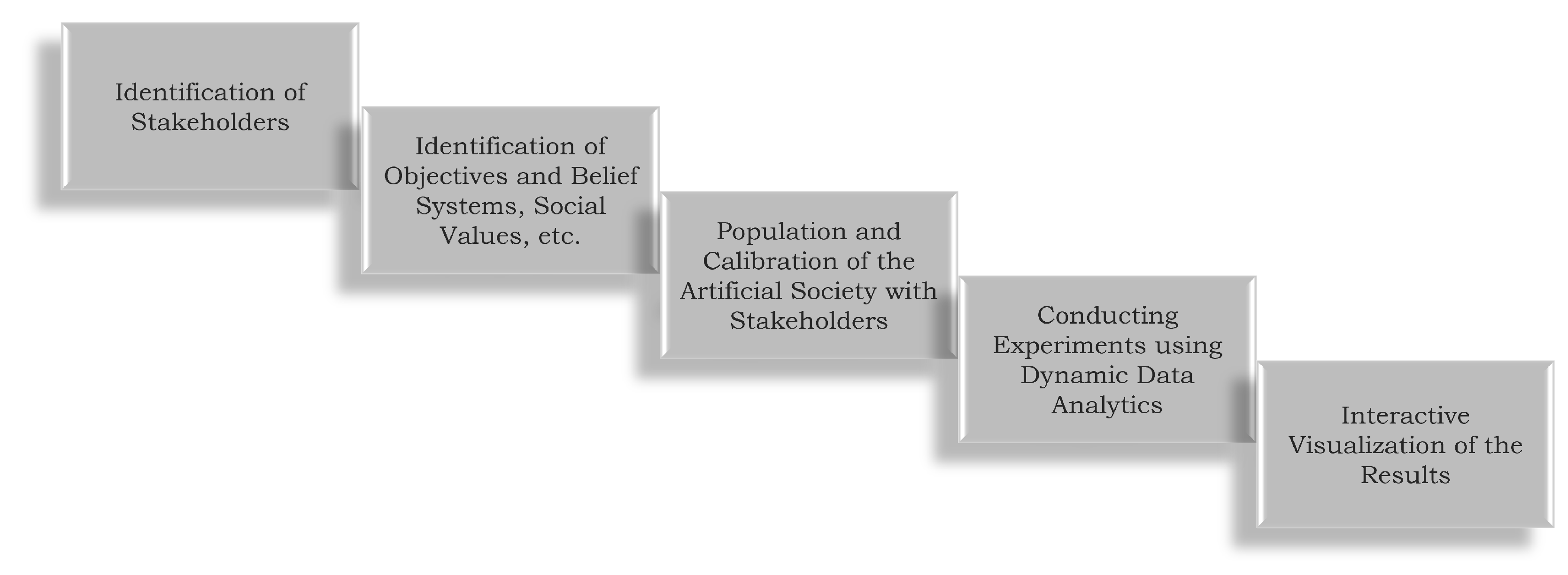
  • The land-use project is clearly defined and described. All affected stakeholders are identified.
  • All stakeholders voice their concerns, but also provide positive feedback. It is important that all input is captured and whenever possible, including the reasons and beliefs for all opinions being considered. As a result, the various stakeholder groups, their objectives and their belief systems are documented.
  • The land-use project is adapted to avoid as many negative impacts as possible while ensuring a majority of positive impacts all under the constraints of the public need for the project itself. All negative impacts are captured in a protocol to be used for the critique and iteration step. In this step, the artificial society is populated with the land-use project data as well as with the representations of the former identified stakeholder groups.
  • A plan is generated for the land-use project and visualized with all identified effects for the experts as well as for the stakeholders. The execution of the populated artificial society via simulation is part of this step.
  • Using the interactive visualization and the protocol with the remaining concerns, the plan can now be calibrated and tailored to provide maximal benefit while avoiding doing harm.
This process is iterative. If no consensus can be reached, it may be necessary to run through the process again.
As discussed previously, this will lead to multiple objectives that often are contradictory. For example, while environmental protection groups want to protect areas from anthropogenic threats, local tourism groups may want to increase access to such areas for recreational activities. Examples of land as an ecological space in conflict management can further guide the discussion [23].
One of the major challenges in land use is the trade-off between such objectives, including those between urban and rural interests [24]. Being able to embed all these viewpoints into the common representation of a system to be able to evaluate the dynamics and emerging behaviors resulting from the interplay of the various views is the objective of the computational tool populated with the results. This process does not avoid or solve conflicts, but it makes sure that the leaders of land-use projects are at least aware of all objectives, so that the decisions can be made in an informed manner and negatively affected groups can be supported accordingly.

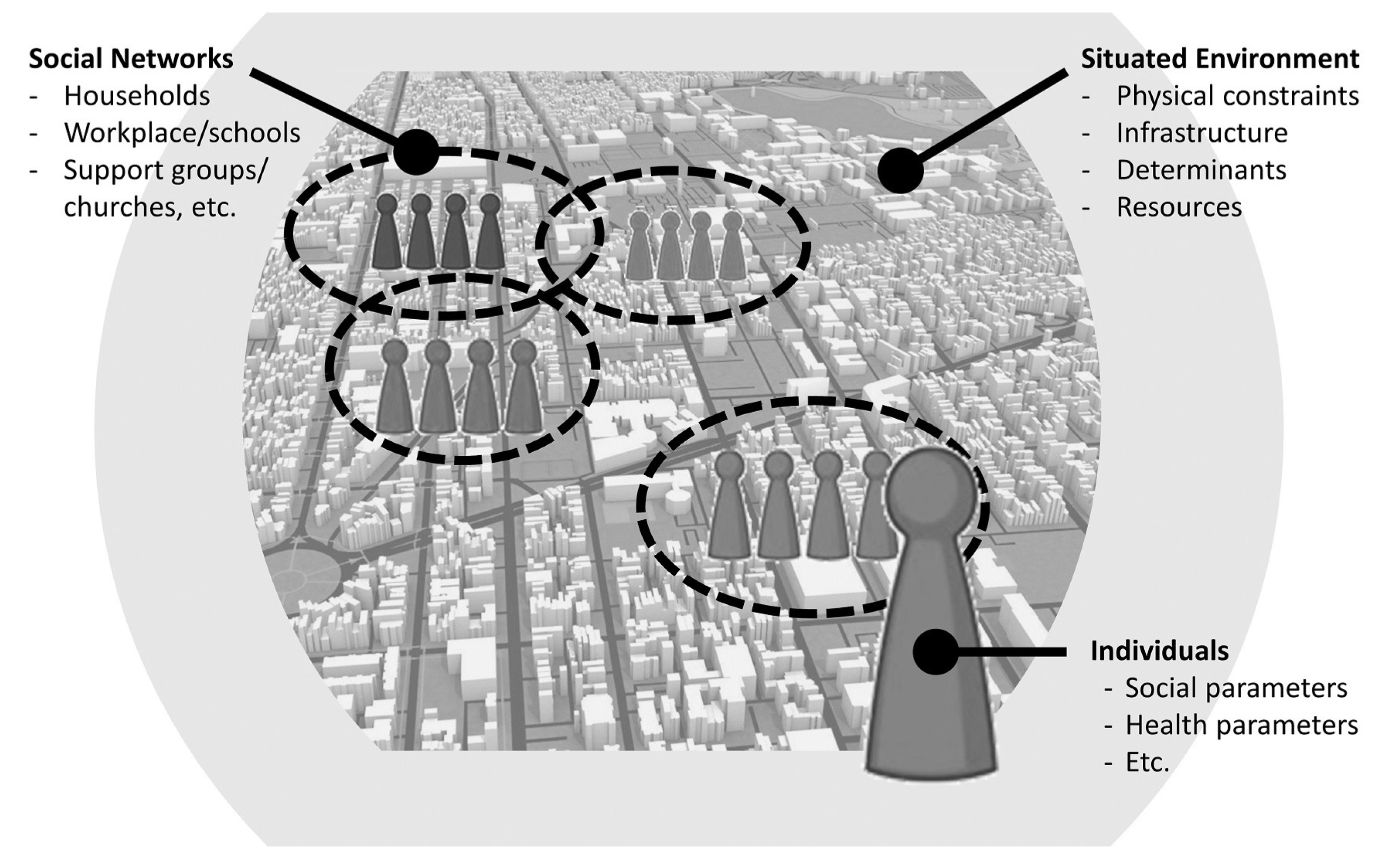
2.3. Artificial Societies as a Computational Decision Support Tool

The process proposed in the last section needs to be supported by tools to ensure that all objectives are captured accordingly. The computational tool we propose to support stakeholder engagement is the construction of artificial societies. As described by Tolk et al. [25], artificial societies advance the agent-based modeling paradigm using social science research to integrate human and social factors, and utilizing three main components:
  • Individual agents reflecting the demographics and attributes of interest;
  • The situated environment with its infrastructure and social determinants;
  • The social networks in which an individual is engaged.
The use of the agent-based paradigm in the domain of computational social science is well established, as described by Epstein and Axtell [26], among others. Their role in expressing and analyzing social behavior in complex systems was only recently emphasized in the research contributions compiled by Davis et al. [27]. Furthermore, in their call for action to the community of artificial societies and social simulation experts, Squazzoni and colleagues emphasized the need to integrate human and social behavior into computational support models when addressing the COVID-19 pandemic [28]. Several leading research institutions provided such support, such as the Argonne National Laboratory [29] and the Center on Social and Economic Dynamics at the Brookings Institution [30], to name only two examples. Figure 2 shows the characteristics of an artificial society.
The individuals of artificial societies are socially capable agents. They are embedded into multiple social networks or groups, such as families, friends, work colleagues, etc. When they make decisions, they take the inputs and the values of these groups into account. The rules they follow are modeled using insights and guidance from the Humanities and Social Sciences. The characteristic attributes of individuals are captured as states within the representing agents, which are also derived from expert inputs. Depending on the problem domain, additional information that is important for an individual also needs to be stored, such as economic constraints, the lived experience of individuals and group members, etc. Finally, individuals have memories that guide their decisions.
Individuals can belong to multiple social groups or social networks with different, maybe even conflicting, values. Each decision process of an individual becomes a multi-criteria, multi-objective challenge in of itself. These social connections can be pivotal for many decisions and state changes. If an event occurs that is negative for an individual, being in a strong group that provides support can save an individual from making a choice with further negative consequences, e.g., having access to “life coaches” can help an individual stay on course. These social networks and groups are represented as dashed lines grouping individuals into various clusters, often organized in formal network architectures.
Finally, everything is embedded into a synthetic situated environment, which provides hard constraints—such as physical barriers as well as access to needed resources or lack thereof–as well as soft constraints such as norms and values, including existing policies and guidelines. Soft constraints might be ignored by individuals, e.g., if they have previously had negative experiences following a similar guideline or following a guideline from the same group of policy makers, or if they are part of a group that is opposed to these guidelines. The environment may also contain social environmental determinants that are important for the policy domain of interest, such as social determinants of health [31].
Another aspect of the environment is that it can embed the digital twins of key components of interest within the environment. The industrial and systems engineering artifacts, which are increasingly based on principles of digital engineering, can also be used to create realistic representations in the synthetic environment. Examples for these approaches are given in [32,33,34].
Artificial societies allow us to capture all the different views and values of individuals, as well as the views and values of the social networks to which they belong. Social determinants can be captured in the environment. Alternative views of experts from different disciplines can be alongside the alternative perceptions resulting from different cultural or social backgrounds, all the way down to modeling individual’s lived experiences. Social science insights from intersectionality theories can be modeled if this is of value to articulate the effects in the model expected by the project management leadership. It is this embeddedness into social networks that enhances the social capabilities of the agents: agents do not simply react to stimuli—they make their decisions in the social context of their social nets, which includes historical and cultural backgrounds as well as their lived experiences.
As the artificial society is extending the ideas of agent-based simulations, one of its significant characteristic attributes is that it allows one to gain numeric insights into the dynamics by executing the simulation. This allows one to take advantage of the various applications already identified in related work [35], but with the advantage of the social implications also being considered by the executing agents. As an example, in [25], the effect of social support in the case of opioid misuse under otherwise identical circumstances was shown. For land-use planning and management, the importance of cultural behavior is increasingly important, as discussed in [36,37], among others. These important attributes and behavioral rules can also be captured in their social context by artificial societies.
Many of the more traditional agent-based models assume that a bounded-rational approach, based on utility maximization, provides a reasonable basis for the decisions of the agents within the model. This is sometimes nested with heuristic rule-based techniques to represent the decision-making mechanisms of households regarding land use for more reality. The land use dynamic simulator LUDAS is an example of this approach [38,39]. Artificial societies can also use such an approach, but these not only support a higher diversity of participating agents but also allow alternative cognitive processes to drive the decisions of socially capable agents [25].
While many of these ideas have been addressed by individual point solutions, using an artificial society allows for the coherent and consistent integration of such views. Furthermore, multiple objectives can be pursued by the simulated individuals, but they can all be evaluated, and their interactions assessed, for the overall project. This requires the embedding of the artificial society simulation within a broader framework of dynamic data analytics, which will be described in the next section.
Furthermore, the land-use management community is increasingly using geographical information system support, employing diverse layers to visualize important information for the team. Artificial societies cannot only use this information to set up the situated environment they act in, but these can also provide “smart layers” displaying their information in insights.

2.4. A Dynamic Data Analytics Framework

Data analysis is the detailed examination of the elements or structure of data. It often involves the use of statistical methods, but also increasingly uses the methods of complex systems analysis. This data analysis is often embedded into an analytics framework, which obtains, stores, and mediates the data that describe the object of analysis. The framework also stores, visualizes, and distributes the post-analysis data containing the insights. By adding the what-if analysis capability, the data analytics framework becomes dynamic and allows us to gain insights into the dynamic behavior of a complex system.
Whenever the question requires taking socio-economic and socio-cultural aspects into consideration, the use of artificial societies promises to support the leadership of land-use projects with a greater awareness of vital and sometimes divergent perspectives. However, the necessary data are not always easy to obtain, and cross-disciplinary experts may not agree upon the exact values of parameters describing the objects of interest, or they may not even know the probability distributions of such values. There may be disagreement among the experts regarding which attributes are characteristic, or experts may even recommend the different utility functions and underlying conceptualizations. The operations research community describes this as deep uncertainty. The Exploratory Modeling Workbench provides methods and tools that can address such challenges [40]. These tools for exploratory modeling and analysis can augment and complement the methods usually applied for the design of experiments [41].
Conducting a what-if analysis upon this extended scale results in a myriad of additional data. Before the results can be presented to a project lead, another round of data analytics is needed, particularly in order to identify the stability of the regions of the solution space under the various constellations as well as identify the singularities, perturbation analysis, sensitivity analysis, parameter-redundancy analysis, and other means of complex system evaluation. Once conducted, data visualization becomes pivotal for communicating these results. Creating an immersive, interactive experience layer allows project leaders to “experience” the effect of their decisions. The more intuitive this “flight simulator for the decision maker” is, the better the decision support will be [42]. Haberlin and Page describe a highly configurable simulation, experimentation, and analytics laboratory that displays the salient analytics findings for project leadership using the latest visualization technologies in the process [43]. Such a laboratory is not needed to provide decision support, but if one is available, the use is highly recommended.
In summary, a dynamic data analytics framework is needed to obtain and prepare the data to instantiate and initialize the elements of the artificial society, to plan and conduct experiments to address deep uncertainty, as required by the project management process, and to evaluate and visualize the results—ideally presenting the multiple objective effects in an interactive, immersive form to the project leadership. This brings the multiple viewpoints and value systems of a cross-disciplinary group or experts and diverse stakeholders into consideration and presents the possible effects of policy decisions in an engaging form.

2.5. Summarizing the Method

We are adapting a process that was successfully developed to support the project managers of cross-disciplinary teams [5]. This process enables the identification of various stakeholders and their diverse objectives and belief systems, and ensures that all resulting challenges are identified. This process is complemented by the artificial society simulation embedded into the data analytic framework. It is obvious that only what is captured in the simulation can later make a difference, as the system is only as good as its configuration. Using data analytic concepts to instantiate and initiate the simulation by obtaining and preparing the data supporting project leadership is good practice.
  • Each group identified while analyzing the problem situation should be represented as a social network in the simulation.
  • The construction of the problem space is used to instantiate the simulation and identify the challenges. The boundary conditions, parameter types, parameter values, state changes, and structure are used to define the simulation configuration. Data analytics needs to support this step.1
  • Populating the artificial society results in designing the solution space results in alternative scenarios, and identifying alternative metrics results in alternative ways of evaluating the results. Both scenarios and metrics are used to configure the simulation system through alternative initialization and evaluation.
  • The different scenarios are then executed, explored, and visualized. This includes using the different evaluation criteria expressing diverse stakeholder values and expert judgments, leading to an iterative process that promotes the critique of various options. What is technically very promising may result in hardships for under-served communities that otherwise would not have been discovered until after the solution is in place. Data analytics help to make sense of the rich set of data provided by the artificial society simulation.
The most important result of applying the method, process, and tool in this way is not a computational simulation, but a decision support tool for project leadership that deepens one’s awareness of the effects of the decision across all cross-disciplinary levels and all relevant social groups, as identified in the process and captured in the tool. The technical feasibility of each of these components has been documented in studies beyond the scope of this article, as can be seen in [25,27,29,44], among others.

3. Applying the Method, Process, and Tool to Address the Multiple Viewpoints of Dam System Stakeholders

This section provides an application example of the method, process, and tool described above, replacing the traditional calculation section for traditional approaches. We use examples from systems with dams to provide examples of the socio-technical challenges facing project leadership, and how the proposed method can help overcome them. The intention here is not to point fingers, but to use the documented real-world examples that are best suited to show the applicability and usefulness of the recommended approach.

3.1. Multiple Viewpoints of Dam System Stakeholders

The dam system stakeholders generally involved in dam safety planning and implementation are currently dam owners, operators, and regulators. The true span of stakeholders with that experience both influence and impact is much larger, and includes upstream communities and decision makers, members of impacted supply chains, local utilities, transportation planners and implementers, and others depending on the watershed and dam and reservoir site, as well as its size, and use. These stakeholders, individually and collectively, may have a considerable impact on the hazard categorization, the potential for overextending the capacity or strength, options to reduce the pressures of and on the dam, and the preparedness of downstream and connected communities to respond to dam emergencies.
Each of these stakeholders is likely to have different priorities regarding how the resilience of the system can be ensured, what the most important benefits and drawbacks of dams and dam operations are, and how connected stakeholders should be made aware of and prepared for potential threats, vulnerabilities, and breach consequences. For example, Lewiston Dam is a high hazard dam on the Trinity River in California that is managed by the Bureau of Reclamation. Water releases from the Lewiston Dam must be managed for dam safety, tribal ceremonies, recreation, upstream and downstream fisheries, as well as downstream hydropower, water supply, and agricultural needs. Numerous lawsuits since the dam’s construction in 1961 have contributed to the current management regime [45].
Applying the process to identify the stakeholders’ viewpoints and using the tool to represent their objectives and priorities provides the leadership with the necessary information to avoid unintended hardships for any stakeholders. Each stakeholder group is represented as a social group within the artificial society. The locations of interest are captured in the situated environment, and causal connections are captured in the simulation. The leadership can now evaluate the effects of their decisions by executing the simulation of the artificial society. The simulation will not only show which parts of the location will be physically affected, but also show whether locations of interest to any stakeholder groups will be affected. The following two use cases provide concrete examples. Each paragraph is followed by a short observation on how the method, process, and predominantly the decision support tool could have addressed the described challenges and improved the situation.

3.1.1. The Edenville and Sanford Dams

A recent example of conflicting stakeholder views is the cascading impacts resulting from the May 2020 storms in Michigan. As the Edenville Dam failed, it sent an uncontrolled release of water downstream which resulted in the failure of the Sanford Dam. The dams were under regulation by the Federal Energy Regulatory Commission (FERC) until 2018, at which point the hydropower licenses were revoked due to noncompliance and the regulatory authority was transferred to the state dam safety program. However, it was over a year before sufficient knowledge transfer and building enabled the program to determine that the dams met neither federal nor state requirements for high hazard dams [46]. Failure investigations indicate that, while the owner of the dams was aware that repairs were needed, the cost of repairs was significantly more than the hydropower revenue from the reservoir [47]. Members of the community were concerned about the health of the lakes and the communities and began to request more information.
There are three application examples in this first paragraph. First, having all information in the decision support tool would have facilitated the transition from FERC to the state dam safety program, cutting the time needed for the knowledge transfer. Second, using the process to coordinate technical and financial experts would have pointed at the revenue gap, as well as at possibly unintended consequences for the Sanford Dam. Lastly, the residents and other stakeholders’ interests and concerns would have been logged and potentially considered in the financial analyses and trade-off conversations.
Community residents formed the Four Lakes Task Force after the revocation of the Edenville Dam hydropower license in an effort to build community support for repair and resilience. The Edenville reservoir, Sanford reservoir, and two others in the area are collectively known as the Four Lakes, which is a popular recreational area for the community. Furthermore, at least one federally threatened species and two state threatened species of mussel were documented in the lakes [48]. While the Task Force was in the process of acquiring and restoring Four Lakes, Edenville and Sanford dams as well as two others were breached or damaged in May 2020, resulting in the evacuation of over 11,000 residents as well as damage to over 2500 structures and 43 road crossings. A temporary passage was required for first responders to reach certain areas of the Midland and Gladwell counties. Fortunately, there were no fatalities as a result of the failure. FEMA credits the strong relationships between the county’s emergency managers, dam operators, and county officials for calling for a preemptive evacuation during daylight hours [46].

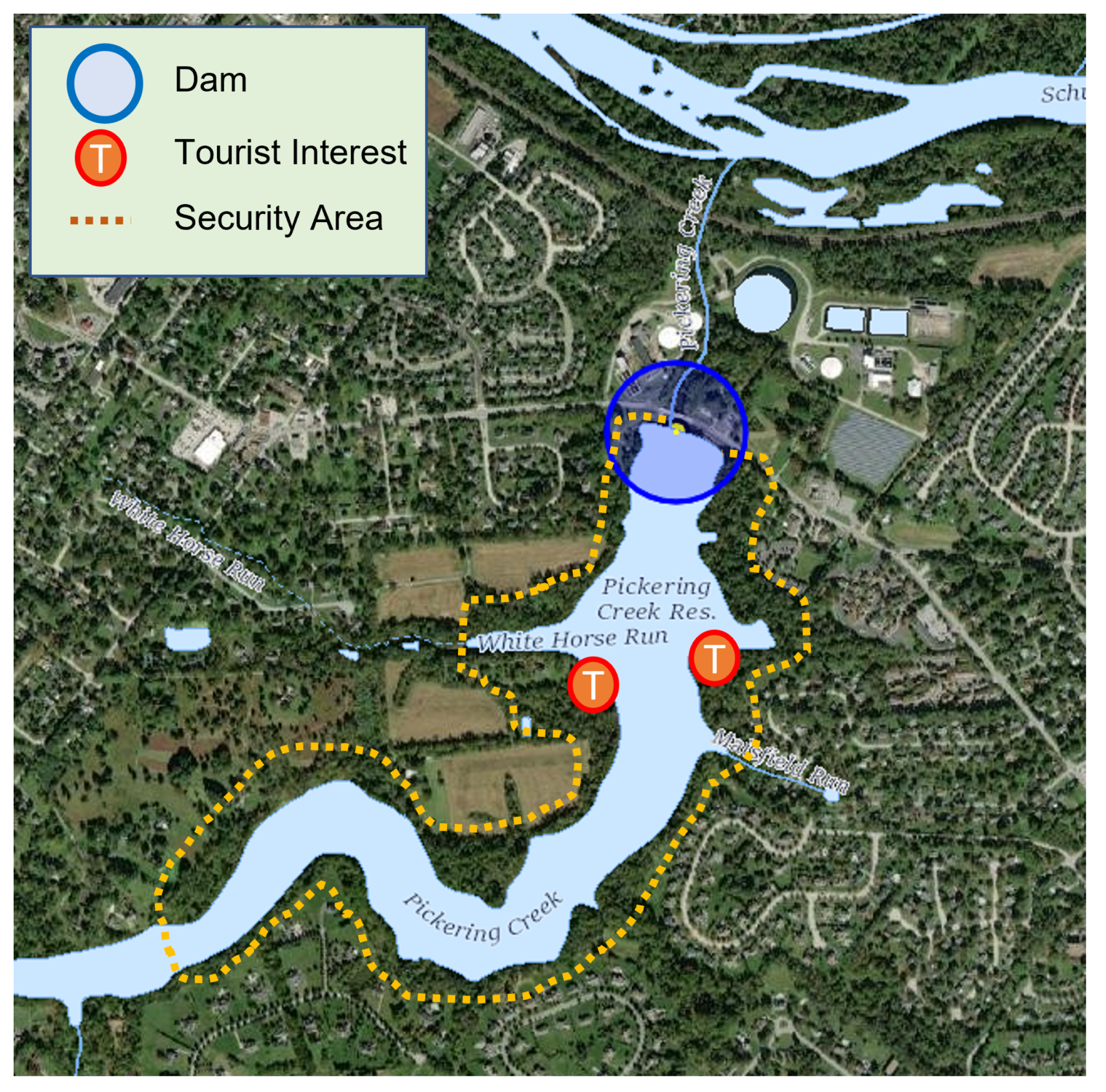
3.1.2. The Pickering Creek Dam

Pickering Creek Dam in Chester County, Pennsylvania, is another example where there are multiple beneficiaries and parties that may impact the health and operations of the dam, however, there were few points of interaction and communication among all stakeholders. This could have been improved by applying the process to bring technical experts and stakeholders together early in the project.
The dam is both a resource and a source of frustration to upstream and downstream residents, as the reservoir provides drinking water and is a pristine bald eagle nesting site but was fenced off around 2000, which prevents fishing and wildlife viewing [49,50]. Residents still host informal posts and discussions lamenting the loss of recreation. The fencing was done to protect the dam and the reservoir following according to a plan devised by security experts. Again, applying the process would have made the technical experts aware that there are additional concerns to be addressed, as the fencing significantly reduces the quality of life of local citizens and decreases the tourism value of the region. The tool could capture the particular regions of interest and help find compromises to maintain access to the nesting site without reducing the technical security. Figure 3 shows this in principle.
The dam overtopped in September 2021, cutting off a main route to town and emergency services, flooding neighborhoods, and compromising the primary water supply for Phoenixville, namely Pickering Creek Reservoir. Alerts were issued for residents and an electrical substation to evacuate due to flooding and dam breach concerns [51]. One person was killed during the flooding. Although residents can ascertain the dam’s condition through the National Inventory of Dams, no information regarding the condition assessment was available through publicly online sources. Residents must visit the Chester County Water Resources Authority in order to view the Emergency Action Plan and plan for future events [52]. Furthermore, the overtopping flooded and restricted access to a bridge that had been repaired and updated in 2015.

4. Results

Section 3 provided two well-documented examples from the domain of dam resilience planning projects. The examples show project management processes that need to take into consideration stakeholder perspectives, their vulnerability to impact, their understanding of risk, their recognition of responsibilities, and their ability to respond and implement or participate in mitigation. For these selected examples, the proposed method and tool processes are applied and analyzed to show how this would facilitate the socially responsible conduct of these projects by providing project leadership with vital input from all relevant experts as well as all affected stakeholder groups.

4.1. The Edenville and Sanford Dams

While evacuation recommendations and the potential damage to structures due to dam breaching are typically included in traditional emergency action plans, targeted recommendations and assessments are generally developed by the populated assessment and decision support tools. Using the information of the situated environment, the effects of breaking dams can be quickly calculated and displayed, including the effects on the accessibility of certain regions. The example of one federally threatened species and two state threatened species is also something which is immediately taken into consideration, as this information is captured along with the corresponding locations.
In addition to residential and transportation infrastructure damages, the local community has been significantly affected by restricted lake access, declining housing prices, and lost local revenue. The Michigan Department of the Environment, Great Lakes, and Energy (EGLE) as well as downstream businesses dedicated resources to ensure flooding did not adversely affect the local water quality. The Four Lakes Task Force, local universities, and EGLE are researching the impact of the damage on local mussels and other nearby wildlife and vegetation to understand the extent of restoration needed and changes in invasive species risks.
Although the focus of the decision support tool should lie in prevention, the information continues to also be important for restorative actions, particularly when several organizations must be aligned to provide services, such as preserving water quality or restoring local wildlife. The decision support tool can also help identify which lake access restrictions affect tourism and the local quality of life the most, so that the positive and negative effects of lake access restrictions can be discussed before they happen. The process can guide the participating stakeholders with quite different objectives and viewpoints of the common challenge, namely to minimize the negative effects while keeping the dam and the reservoir safe. Table 1 summarizes these examples for the Edenville Dam.

4.2. The Pickering Creek Dam

The greater documentation of the multiple stakeholder perspectives—utility, state dam safety, transportation, and environment offices, local decision makers, residents and recreational area users, emergency responders—would allow for these multiple points of potential conflict to be logged and assessed in a more transparent fashion. For example, residents have expressed frustration with water prices, loss of access to the reservoir (a 1979 National Dam Safety Program investigation indicates that the reservoir has been closed due to swimming and boating but did not specifically prevent fishing or shoreline access [53]). Furthermore, greater understanding of the needs of the stakeholders may have led to different decisions regarding the timing and extent of the emergency alerts. Twitter indicates that the evacuation alert was issued at 1:26 AM, when some residents may have slept through the alert. Other stakeholders in the area did not receive the alert, including at least one resident who was stuck in a four-hour traffic closure, as documented in Tweets, such as [54,55,56].
The decision support tool would have allowed conflicting stakeholder priorities to be evaluated in a consistent and transparent manner, with the ideal outcome of compromises on each side (e.g., recreational viewing access and an increased understanding of the water utility rates needed to maintain the dam). This would identify the gaps in emergency notification and route determinations to support public safety during emergency situations. Lastly, it may have led to discussions on whether the 2015 bridge repair should have included updates to account for more severe weather events. Table 2 summarizes these examples for the Pickering Creek Dam.

4.3. Application of Method and Tool Support

The incorporation of a synthetic population methodology allows project leaders to understand all the relevant perspectives as well as possibly forecast the undesired and unintended policy consequences, because all relevant technical experts and affected stakeholder groups can provide the information needed for technically competent and socially responsible project leadership. Only when all stakeholders are identified and their positions and viewpoints are understood can they be documented in the tool as entities and social nets. The environmental data necessary to drive simulations needs to be imported, and artificial society scenarios must address the challenges identified. Table 3 provides an overview of how the populated tool can serve as a computational decision support for leadership.
The use of tool support facilitates the project being conducted in the expected time, within the required scope, with the desired quality, and within the given budget. Moreover, the scope and quality are extended to ensure that the project leadership becomes aware of all relevant views and objectives of affected stakeholder groups. Trade-offs and compromises may still be necessary, but if something of value to a group is negatively affected, then it happens knowingly, not out of ignorance.

5. Discussion

The proposed cross-disciplinary process and supporting computational decision support tool can be augmented and extended by several ideas discussed in this journal. The open and modular concept of dynamic data analytics around an artificial society allows the integration of many supporting ideas to facilitate the creation of a common understanding of the multiple facets of land-use projects.
One of the important next steps must be to make participation in such processes easier for non-engineers. The currently applied solutions assume that users are educated in the various paradigms, but such engineering-focused tools may not be able to capture the insights grounded in the lived experiences and vital community-borne values, particularly when dealing with obtaining the viewpoints and objectives of minority groups and under-served communities. We therefore need better modeling tools for non-modelers to increase the openness to cognitive diversity and experiential variations, thereby supporting the democratization of land-use planning and management processes [57]. While this work of Shaikh et al. targets the policy level, Harper and Mustafee provide initial research design ideas for such participatory approaches in healthcare at the procedural level [58]. Both approaches may also be adapted accordingly for land-use planning and management. Another possibility is to integrate role play with traditional operations research to generate behavior that can be supported by the agent-based simulation implementing the artificial society, which is an extension of the ideas presented by Castella, Trung, and Boissau [4]. An interesting approach using games of interest in land-use planning and management has been presented by Tepnadze et al. [59].
The proposed computational decision support tool aligns well with the vision provided by BenDor et al. in their research agenda [60]. Although their focus lies in ecosystem planning, their insights regarding how the use of ecosystem services in planning could improve the assessment and communication of planning trade-offs and outcomes could also be transferred to the proposed solution in this paper, particularly as the artificial societies enable the exploration of a broader set of viewpoints and beliefs in a socio-technical system, including but not limited to ecosystem aspects.
While earlier volumes of this journal have tended to focus more on use cases and examples of general interest, the recent volumes include increasingly contributions concerned with decision support and conflict resolution in land-use planning and management. Particularly the work on multi-criteria decision analysis, only recently presented in [61], provides a valuable addition of capabilities. The proposed dynamic data analytics framework can deliver all the data identified to be necessary in cost-efficient plan development and land-use planning requirements. The vision of a spatial decision support system architecture and social process to inform, involve, and ultimately empower stakeholders discussed in their paper is a very good fit in terms of complementing the proposal made herein, as it is also data-driven. Another publication with a focus resembling that of our proposed solution describes the use of a geospatial decision support tool [62], enhanced by benefit maps visualizing multi-objectives, which were discussed herein. Even the static presentation led to very active engagement. We postulate that, with the possibility of understanding the dynamic development of the socio-technical system and the possibility of conducting what-if analyses of alternatives, this engagement could be increased.
Furthermore, the use cases discussed herein can be generalized and extended, arguing that the method, process, and tool should be useful in other projects that require both technical and social competence within project leadership.
  • Project documentation: A project is well documented when all aspects of a complex, cross-disciplinary, socio-economic, and socio-cultural project are addressed by the method, brought into the project through the process, captured in the tool, and presented in analytics feedback to project leaders.
  • Cross-disciplinary expert integration: Socio-technical systems require input from various disciplines. The proposed process helps identify the various inputs of such experts and integrate their insights into the tool, either as complementary or as competing solutions.
  • Equity and democratization: Minority groups and under-served communities obtain a place at the table with all other affected social groups, contributing their values and objectives as well as their lived experiences via the process into the tool, so that the project leadership can consider these views as decision parameters within the project.
  • Project management: The what-if analysis capability provided by the tool promotes both the evaluation of various options and the communication of results using interactive and immersive visualization. This supports balanced trade-offs between stakeholder perspectives. Furthermore, the expected behavior projected by the tool can serve as a guide for tracing actual project developments.
  • Coordination of responsibilities: As the examples suggest, the management of socio-technical systems is complicated by having many uncoordinated stakeholders. However, these are also entangled with many organizations responsible for certain aspects of the system, yet not under common leadership. Capturing the responsible organizations in the tool promotes the coordination of their actions. In particular, when responsibilities change or new organizations enter the project, the tool can rapidly bring newcomers up to speed, facilitating their understanding of the possible effects of policy decisions.
Many domain-specific solutions also are implemented in other organizations, such as the web-based, dam-break flood-simulation model Decision Support System for Water Infrastructural Safety (DSS-WISE™) of the National Center for Computational Hydroscience and Engineering, or the United States Army Corps of Engineers’ Hydrologic Engineering Center River Analysis Software (HEC-RAS), both described in detail by Salt [63]. The aforementioned immersive and interactive visualization capability described by Haberlin and Page [43], implementing among other ideas captured by Rouse [64], is another example.
Within the domain of land-use planning, this methodology is ideal for zoning and infrastructure planning [65], mixed-use development, brownfields development [66], and any other land-use development with multiple stakeholders with potentially differing priorities.
McDermott et al. [67] make a powerful argument for equity in land-use planning. In their paper, they stated that “the escalation of targets for land use, in particular, is disconnected from targeted geographies, lacks accountability to socially diverse knowledge and priorities, and is readily appropriated by powerful actors at multiple scales. This paper argues instead, for an equity-based approach to transformation that reveals how unequal power distorts both the ends and the means of global governance.” The process and tools proposed in this paper and exemplified using the dam resilience use cases show that the objective of providing the land-use planner with all the identified relevant socio-economic factors can be reached.

6. Conclusions

The objective of the proposed integrative solution is to enable better land-use planning and management through better-informed decision making. The technical components of this solution have been successfully applied in other application domains. The presented application in support of the leadership of dam projects is just another example to show the applicability of both computational insights into socio-economic impacts of decisions in the constraints of the model and providing ethical insights for project leadership, ensuring that all the relevant viewpoints, values, and objectives of the members of the society are considered. While the work described herein showed this feasibility, conducting the proof of concept is the next logical step.
From a technological perspective, we also need better tools to specify artifacts within artificial societies (entities, attributes and states, state changes and processes, etc.). The use of artificial intelligence and machine learning solutions to instantiate and initialize entities has been successfully applied, but these were very problem-specific solutions that need to be generalized so that they become tools applicable to a broader community.
The continuing support of projects by model-based system engineering (MBSE) approaches that are increasingly taking advantage of digital engineering (DE) methods also contributes to the proposed solutions. As more and more artifacts of MBSE/DE are used to design digital twins, these solutions can also be used to configure the situated environment of the artificial society, so that technologically reliable solutions can be provided.
However, technical solutions, such as a digital twin approach, or even an artificial society approach using dynamic data analytics, fall short if they do not use a guiding process that identifies all stakeholders (diversity), includes them in the planning and decision process (inclusion), and gives all voices a forum in which they can be heard and contribute (equity). Using the proposed solution enables the social and economic responsibilities of land-use planners to be fulfilled.
In summary, the technical feasibility of the proposed solution has been shown, and the benefits of using the method and tool to provide a better socially and culturally aware set of options have been demonstrated for the use case of dam projects. Nonetheless, it is not limited to the dam use case examples here, but can be generalized to address the challenges in socio-technical systems, such as water resource evaluations or climate change effects. The authors believe that this approach can be generalized to support better project leadership in a society that supports all its members by taking their values and objectives into account in the decision-making process.

Author Contributions

Conceptualization, A.T. and J.A.R.; methodology, A.T., F.L.S., and W.J.W.; formal analysis, J.A.R.; investigation, J.A.R.; data curation, A.T. and J.A.R.; writing—original draft preparation, all; writing—review and editing, all; visualization, J.A.R.; supervision, A.T.; project administration, A.T. All authors have read and agreed to the published version of the manuscript.

Funding

This research received no external funding.

Institutional Review Board Statement

Not applicable.

Informed Consent Statement

Not applicable.

Data Availability Statement

Not applicable.

Acknowledgments

The authors would like to thank the MITRE Innovation Program for the support of parts of the research needed to lead to the recommended framework. They also thank their colleagues who helped shape the ideas with discussions and contributions. Tolk’s and Richkus’ affiliation with MITRE are provided for identification purposes only and are not intended to convey or imply concurrence with, or support for, the positions, opinions, or viewpoints expressed by these authors. This report has been approved for Public Release, Distribution Unlimited. Public Release Case Number 21-01672-17.

Conflicts of Interest

The authors declare no conflict of interest.

Note

1
In the healthcare example [25], more than 40 million research articles were scanned, resulting in the identification of 250 highly vetted articles that were used to identify attributes, parameters, and state change options.

References

  1. Millington, A. Land—A Multidisciplinary Journal Addressing Issues at the Land Use and Sustainability Nexus. Land 2012, 1, 1. [Google Scholar] [CrossRef]
  2. Belcakova, I. New approaches to the integration of ecological, social and economic aspects in land-use planning. Int. J. Ecol. Probl. Biosph. 2003, 22, 183–189. [Google Scholar]
  3. White House. Executive Order 13985–Advancing Racial Equity and Support for Underserved Communities through the Federal Government, 20 January 2021. Available online: https://public-inspection.federalregister.gov/2021-01753.pdf (accessed on 14 December 2022).
  4. Castella, J.C.; Trung, T.N.; Boissau, S. Participatory simulation of land-use changes in the northern mountains of Vietnam: The combined use of an agent-based model, a role-playing game, and a geographic information system. Ecol. Soc. 2005, 10, 27. [Google Scholar] [CrossRef]
  5. Shults, F.L.; Wildman, W.J. Human simulation and sustainability: Ontological, epistemological, and ethical reflections. Sustainability 2020, 12, 10039. [Google Scholar] [CrossRef]
  6. Tolk, A. Simulation-Based Optimization: Implications of Complex Adaptive Systems and Deep Uncertainty. Information 2022, 13, 469. [Google Scholar] [CrossRef]
  7. American Society for Civil Engineers (ASCE). Dam Infrastructure. 2022. Available online: https://infrastructurereportcard.org/cat-item/dams/ (accessed on 20 December 2022).
  8. U.S. Army Corps of Engineers (USACE). National Inventory of Dams. 2022. Available online: https://nid.sec.usace.army.mil (accessed on 21 November 2022).
  9. American Society for Dam Safety Operators (ASDSO). Dam Facts and Stats for the Media and Public. 2022. Available online: https://dev.damsafety.org/media/statistics (accessed on 20 December 2022).
  10. O’connor, P.; Saulsbury, B.; Hadjerioua, B.; Smith, B.T.; Bevelhimer, M.; Pracheil, B.M.; Kao, S.C.; Mcmanamay, R.A.; Samu, N.M.; Uria Martinez, R.; et al. Hydropower Vision A New Chapter for America’s 1st Renewable Electricity Source; Technical Report; Oak Ridge National Lab. (ORNL): Oak Ridge, TN, USA, 2016. [Google Scholar]
  11. Mallakpour, I.; AghaKouchak, A.; Sadegh, M. Climate-induced changes in the risk of hydrological failure of major dams in California. Geophys. Res. Lett. 2019, 46, 2130–2139. [Google Scholar] [CrossRef]
  12. Fluixá-Sanmartín, J.; Altarejos-García, L.; Morales-Torres, A.; Escuder-Bueno, I. Climate change impacts on dam safety. Nat. Hazards Earth Syst. Sci. 2018, 18, 2471–2488. [Google Scholar] [CrossRef]
  13. Cumberland Hoke Regional Hazard Mitigation Planning Committee. Cumberland Hoke Regional Hazard Mitigation Plan. 2020. Available online: https://www.cumberlandcountync.gov/docs/default-source/emergency-services-documents/hazard-mitigation-plan-final-draft.pdf (accessed on 20 November 2022).
  14. Federal Highways Administration (FHWA). PDDM Chapter 7-Hydrology and Hydraulics. 2018. Available online: https://flh.fhwa.dot.gov/resources/design/pddm/Chapter_07.pdf (accessed on 20 November 2022).
  15. Federal Highways Administration (FHWA). Highways in the River Environment-Floodplains, Extreme Events, Risk, and Resilience (HEC-17 2nd Edition). 2016. Available online: https://www.fhwa.dot.gov/engineering/hydraulics/pubs/hif16018.pdf (accessed on 20 November 2022).
  16. Berman, T. For the Taking. The Garrison Dam and the Tribal Taking Area; Technical Report 68; International Work Group for Indigenous Affairs (IWGIA): Copenhage, Denmark, 1991; pp. 147–153. [Google Scholar]
  17. Scudder, T.T. The Future of Large Dams: Dealing with Social, Environmental, Institutional and Political Costs; Earthscan: London, UK, 2012. [Google Scholar]
  18. Korbel, W.; Suchoń, F.; Łapuszek, M. Water Dams of the Krakow Fortress: Potential of a Vanishing Heritage. Land 2021, 10, 1273. [Google Scholar] [CrossRef]
  19. National Academy of Sciences. Facilitating Interdisciplinary Research; Technical Report; National Academies Press: Washington, DC, USA, 2004. [Google Scholar]
  20. Tolk, A.; Harper, A.; Mustafee, N. Hybrid models as transdisciplinary research enablers. Eur. J. Oper. Res. 2021, 291, 1075–1090. [Google Scholar] [CrossRef]
  21. Royston, G. Operational Research for the Real World: Big questions from a small island. J. Oper. Res. Soc. 2013, 64, 793–804. [Google Scholar] [CrossRef]
  22. Polk, M. Transdisciplinary co-production: Designing and testing a transdisciplinary research framework for societal problem solving. Futures 2015, 65, 110–122. [Google Scholar] [CrossRef]
  23. Dong, G.; Liu, Z.; Niu, Y.; Jiang, W. Identification of Land Use Conflicts in Shandong Province from an Ecological Security Perspective. Land 2022, 11, 2196. [Google Scholar] [CrossRef]
  24. Fienitz, M.; Siebert, R. Urban versus rural? Conflict lines in land use disputes in the urban–rural fringe region of Schwerin, Germany. Land 2021, 10, 726. [Google Scholar] [CrossRef]
  25. Tolk, A.; Rouse, W.B.; Pires, B.S.; Cline, J.C.; Diallo, S.Y.; Russell, S.A. Applicability of Artificial Societies to Evaluate Healthcare Policies. Simul. Healthc. 2023, in press. [CrossRef]
  26. Epstein, J.M.; Axtell, R. Growing Artificial Societies: Social Science from the Bottom Up; Brookings Institution Press: Washington, DC, USA, 1996. [Google Scholar]
  27. Davis, P.K.; O’Mahony, A.; Pfautz, J. Social-Behavioral Modeling for Complex Systems; John Wiley & Sons: Hoboken, NJ, USA, 2019. [Google Scholar]
  28. Squazzoni, F.; Polhill, J.G.; Edmonds, B.; Ahrweiler, P.; Antosz, P.; Scholz, G.; Chappin, E.; Borit, M.; Verhagen, H.; Giardini, F.; et al. Computational models that matter during a global pandemic outbreak: A call to action. J. Artif. Soc. Soc. Simul. 2020, 23, 4298. [Google Scholar] [CrossRef]
  29. Ozik, J.; Wozniak, J.M.; Collier, N.; Macal, C.M.; Binois, M. A population data-driven workflow for COVID-19 modeling and learning. Int. J. High Perform. Comput. Appl. 2021, 35, 483–499. [Google Scholar] [CrossRef]
  30. Parker, J.; Epstein, J.M. A distributed platform for global-scale agent-based models of disease transmission. Acm Trans. Model. Comput. Simul. (TOMACS) 2011, 22, 1–25. [Google Scholar] [CrossRef]
  31. Mahamoud, A.; Roche, B.; Homer, J. Modelling the social determinants of health and simulating short-term and long-term intervention impacts for the city of Toronto, Canada. Soc. Sci. Med. 2013, 93, 247–255. [Google Scholar] [CrossRef]
  32. Schluse, M.; Priggemeyer, M.; Atorf, L.; Rossmann, J. Experimentable digital twins—Streamlining simulation-based systems engineering for industry 4.0. IEEE Trans. Ind. Inform. 2018, 14, 1722–1731. [Google Scholar] [CrossRef]
  33. Shahat, E.; Hyun, C.T.; Yeom, C. City digital twin potentials: A review and research agenda. Sustainability 2021, 13, 3386. [Google Scholar] [CrossRef]
  34. Corrado, C.R.; DeLong, S.M.; Holt, E.G.; Hua, E.Y.; Tolk, A. Combining green metrics and digital twins for sustainability planning and governance of smart buildings and cities. Sustainability 2022, 14, 12988. [Google Scholar] [CrossRef]
  35. Matthews, R.B.; Gilbert, N.G.; Roach, A.; Polhill, J.G.; Gotts, N.M. Agent-based land-use models: A review of applications. Landsc. Ecol. 2007, 22, 1447–1459. [Google Scholar] [CrossRef]
  36. Brennan, M.A. The Importance of Incorporating Local Culture into Community Development: FCS9232/FY773, 10/2005. EDIS 2005, 2005. [Google Scholar] [CrossRef]
  37. le Polain de Waroux, Y.; Garrett, R.D.; Chapman, M.; Friis, C.; Hoelle, J.; Hodel, L.; Hopping, K.; Zaehringer, J.G. The role of culture in land system science. J. Land Use Sci. 2021, 16, 450–466. [Google Scholar] [CrossRef]
  38. Le, Q.B.; Park, S.J.; Vlek, P.L.; Cremers, A.B. Land-Use Dynamic Simulator (LUDAS): A multi-agent system model for simulating spatio-temporal dynamics of coupled human–landscape system. I. Structure and theoretical specification. Ecol. Inform. 2008, 3, 135–153. [Google Scholar] [CrossRef]
  39. Le, Q.B.; Park, S.J.; Vlek, P.L. Land Use Dynamic Simulator (LUDAS): A multi-agent system model for simulating spatio-temporal dynamics of coupled human–landscape system: 2. Scenario-based application for impact assessment of land-use policies. Ecol. Inform. 2010, 5, 203–221. [Google Scholar] [CrossRef]
  40. Kwakkel, J.H. The Exploratory Modeling Workbench: An open source toolkit for exploratory modeling, scenario discovery, and (multi-objective) robust decision making. Environ. Model. Softw. 2017, 96, 239–250. [Google Scholar] [CrossRef]
  41. Wu, C.J.; Hamada, M.S. Experiments: Planning, Analysis, and Optimization; John Wiley & Sons: Hoboken, NJ, USA, 2011. [Google Scholar]
  42. Rouse, W.B. Understanding the complexity of health. Syst. Res. Behav. Sci. 2021, 38, 197–203. [Google Scholar] [CrossRef]
  43. Haberlin, R.J.; Page, E.H. Visualization support to strategic decision-making. Simul. Warg. 2022, 317–334. [Google Scholar] [CrossRef]
  44. Diallo, S.Y.; Wildman, W.J.; Shults, F.L.; Tolk, A. Human Simulation: Perspectives, Insights, and Applications; Springer Nature: Cham, Switzerland, 2019. [Google Scholar]
  45. Trinity River Restauration Program (TRRP). Trinity River Restauration Program Website. 2023. Available online: https://www.trrp.net/ (accessed on 3 April 2023).
  46. Federal Emergency Management Agency (FEMA). Michigan Dam Incident Response Review. 2022. Available online: https://www.fema.gov/sites/default/files/documents/fema_michigan-dam-incident-response-review_report.pdf (accessed on 16 December 2022).
  47. France, J.W.; Alvi, I.A.; Miller, A.C.; Williams, J.L.; Higinbotham, S. Final Report: Investigation of Failures of Edenville and Sanford Dams. 2022. Available online: https://damsafety-prod.s3.amazonaws.com/s3fs-public/files/Edenville-Sanford_Final%20Report_Main%20Report%20and%20Appendices.pdf (accessed on 16 December 2022).
  48. Woolnaugh, D.; Zanatta, D. Sanford Lake–Initial Mussel Report for Four Lakes Task Force. Central Michigan University. 2021. Available online: https://www.four-lakes-taskforce-mi.com/uploads/1/2/3/1/123199575/08.j_sanford_lake_T1\textendash_initial_mussel_report_for_four_lakes_task_force_may3_2021_cmu.pdf (accessed on 24 October 2022).
  49. Chester Water Facts. Case Study of Springton Reservoir-Save Chester Water. 2020. Available online: https://chesterwaterfacts.com/case-study-of-springton-reservoir (accessed on 15 January 2023).
  50. Phoenixville Regional Planning Committee (PRPC). Phoenixville Regional Comprehensive Plan 2021. 2021. Available online: https://www.phoenixville.org/332/Phoenixville-Regional-Comprehensive-Plan (accessed on 24 November 2022).
  51. Pennsylvania Emergency Management Agency (PEMA). 9 September 2021; Status Report. 2021. Available online: https://www.pema.pa.gov/Response/Internal-Operations/CWWC/Daily%20Incident%20Reports/20210909%20Daily%20Report.pdf (accessed on 24 November 2022).
  52. Chester County Water Resources Agency (CCWRA). CCWRA Dam Safety Emergency Action Plans. 2011. Available online: https://www.chesco.org/DocumentCenter/View/7781/EAP_FAQsGeneral8-10-11 (accessed on 24 November 2022).
  53. U.S. Army Corps of Engineers (USACE). National Dam Safety Program Phase I Investigation Pickering Creek Dam. 1979. Available online: https://apps.dtic.mil/sti/pdfs/ADA063037.pdf (accessed on 4 November 2022).
  54. Tweet. @ameliacomments on 2 September 2021. Available online: https://twitter.com/ameliacomments/status/1433398993439150090 (accessed on 1 December 2022).
  55. Tweet. @zooropababy on 2 September 2021. Available online: https://twitter.com/zooropababy/status/1433472958606069762 (accessed on 1 December 2022).
  56. Tweet. @MCpublicsafety on 2 September 2021. Available online: https://twitter.com/MCpublicsafety/status/1433305412376350728 (accessed on 1 December 2022).
  57. Shaikh, Y.; Jeelani, M.; Gibbons, M.; Livingston, D.; Williams, D.; Wijesinghe, S.; Patterson, J.; Russell, S. Centering and Collaborating with Community Knowledge Systems: Piloting a Novel Participatory Modeling Approach. Equity Health 2023, 22, 45. [Google Scholar] [CrossRef]
  58. Harper, A.; Mustafee, N. Participatory design research for the development of real-time simulation models in healthcare. Health Syst. 2023. [Google Scholar] [CrossRef]
  59. Tepnadze, M.; de Vries, W.T.; Diaz, P.D.; Bichia, Q. An Experimental Study of the Social Dimension of Land Consolidation Using Trust Games and Public Goods Games. Land 2022, 11, 2322. [Google Scholar] [CrossRef]
  60. BenDor, T.K.; Spurlock, D.; Woodruff, S.C.; Olander, L. A research agenda for ecosystem services in American environmental and land use planning. Cities 2017, 60, 260–271. [Google Scholar] [CrossRef]
  61. Gallo, J.A.; Lombard, A.T.; Cowling, R.M.; Greene, R.; Davis, F.W. Meeting Human and Biodiversity Needs for 30x30 and beyond with an Iterative Land Allocation Framework and Tool. Land 2023, 12, 254. [Google Scholar] [CrossRef]
  62. Brom, P.; Engemann, K.; Breed, C.; Pasgaard, M.; Onaolapo, T.; Svenning, J.C. A Decision Support Tool for Green Infrastructure Planning in the Face of Rapid Urbanization. Land 2023, 12, 415. [Google Scholar] [CrossRef]
  63. Salt, D.V. A Comparison of HEC-RAS and DSS-WISE Lite 2D Hydraulic Models for a Rancho Cielito Dam Breach. Master’s Thesis, California State University, Sacramento, CA, USA, 2019. [Google Scholar]
  64. Rouse, W.B. Modeling and Visualization of Complex Systems and Enterprises: Explorations of Physical, Human, Economic, and Social Phenomena; John Wiley & Sons: Hoboken, NJ, USA, 2015. [Google Scholar]
  65. Hammad, A.W.; Akbarnezhad, A.; Haddad, A.; Vazquez, E.G. Sustainable zoning, land-use allocation and facility location optimisation in smart cities. Energies 2019, 12, 1318. [Google Scholar] [CrossRef]
  66. Kantor-Pietraga, I.; Zdyrko, A.; Bednarczyk, J. Semi-natural areas on post-mining brownfields as an opportunity to strengthen the attractiveness of a small town. An example of radzionków in southern Poland. Land 2021, 10, 761. [Google Scholar] [CrossRef]
  67. McDermott, C.L.; Montana, J.; Bennett, A.; Gueiros, C.; Hamilton, R.; Hirons, M.; Maguire-Rajpaul, V.A.; Parry, E. Transforming land use governance: Global targets without equity miss the mark. Environ. Policy Gov. 2022. [Google Scholar] [CrossRef]
Figure 1. Overview of the proposed method, process, and tools.
Land 12 00952 g001
Figure 2. Artificial societies with their individuals in their social networks within the situated environment [25].
Land 12 00952 g002
Figure 3. The decision support tool displays the points of tourist interest as within the security area recommended to be fenced off (this is only an example—no real data are displayed).
Land 12 00952 g003
Table 1. Stakeholders, objectives, and challenges identified by the method in the Edenville example.
StakeholderObjectivesChallenges
Federal Energy Regulatory Commission (FERC)Regulation of hydropower damsDiffering hazard regulations from state dam safety programs
MI Environment, Great Lakes, and EnergyRegulation of non-federal, non-hydropower dams, water quality, fishing, wildlife protectionDiffering hazard regulations from state dam safety program; balancing the protection of endangered species, permitted uses, and water quality
ResidentsBoating, fishing, hiking, wildlife viewing, swimming, housing pricesOwnership of the lake bottom and access are split across multiple parties, making lake level preferences potentially contentious; recreational use may also be in conflict with water quality and wildlife best practices; residents are also in need of safe transportation routes and flood prevention
Local businessesIncreased business due to area visitorsSpeed of regulatory approval of restoration plans
Army Corps of EngineersIdentify flood impact reduction activities and projectsFour Lakes Dams are not flood control dams, but USACE is responsible for flood impact reduction
Department of TransportationFunctioning transportation systemsCosts of temporary access development, road repair, erosion control, stormwater management
Emergency respondersEmergency response access and information awarenessUnder FERC, some information is protected under infrastructure laws [46]
Local development agenciesExpanding economic and social developmentProportion of impervious land use affecting watershed management flood control
Table 2. Stakeholders, objectives, and challenges identified by the method in the Pickering Creek Dam example.
StakeholderObjectivesChallenge
Pennsylvania Department of the Environmental ProtectionRegulation of non-federal, non-hydropower dams, water quality, fishing, and wildlife protectionState dam safety program inspections; balancing the protection of endangered and threatened species, permitted uses, and water quality
ResidentsBoating, fishing, hiking, wildlife viewing, swimming, and housing pricesRecreational use restrictions such as fishing and hiking; loss of transportation, evacuation services; flood mitigation
Local businessIncreased business due to area visitorsRecreational use restrictions, loss of transportation, supply chain services
Local water utilityMaintain drinking water resourceResidential use of reservoir for non-drinking water uses, flood impact reduction
Department of TransportationFunctioning transportation systemsCosts of temporary access development, road repair, erosion control, stormwater management
Emergency respondersEmergency response access and information awarenessConsistent and timely messaging of emergency notifications, access to emergency routes
Local development agenciesExpanding economic and social developmentProportion of impervious land use affecting watershed management flood control
Table 3. Applying Tools Support for Land-Use Planning.
StakeholdersChallengeScenarioTool SupportResult
ResidentsAccess to resourcesShared resource spacesVisualization of resource utilizationTrade-off and compromises on resource access
Minority groupsProtection of culturally important landmarks (burial grounds, religious place, etc.)Creating protected areasVisualization of protected areas for awarenessTrade-off and analysis of compromises
UtilitiesFlood mitigationShared cost of maintaining and improving the dam for multiple uses (e.g., flood mitigation, water resources, hydropower)Shared cost models reflecting the various objectives of social and economic groupsTrade-off between the multi-objective challenges
RegulatorsEmergency evacuationUpdated emergency alert plan and timelinessSimulation of “what-if” cases for emergency situationsAlignment of emergency alert plans between all social groups
Disclaimer/Publisher’s Note: The statements, opinions and data contained in all publications are solely those of the individual author(s) and contributor(s) and not of MDPI and/or the editor(s). MDPI and/or the editor(s) disclaim responsibility for any injury to people or property resulting from any ideas, methods, instructions or products referred to in the content.

