
Assessing the Spatial Agricultural Land Use Transition in Thiès Region, Senegal, and Its Potential Driving Factors

Abstract
:1. Introduction
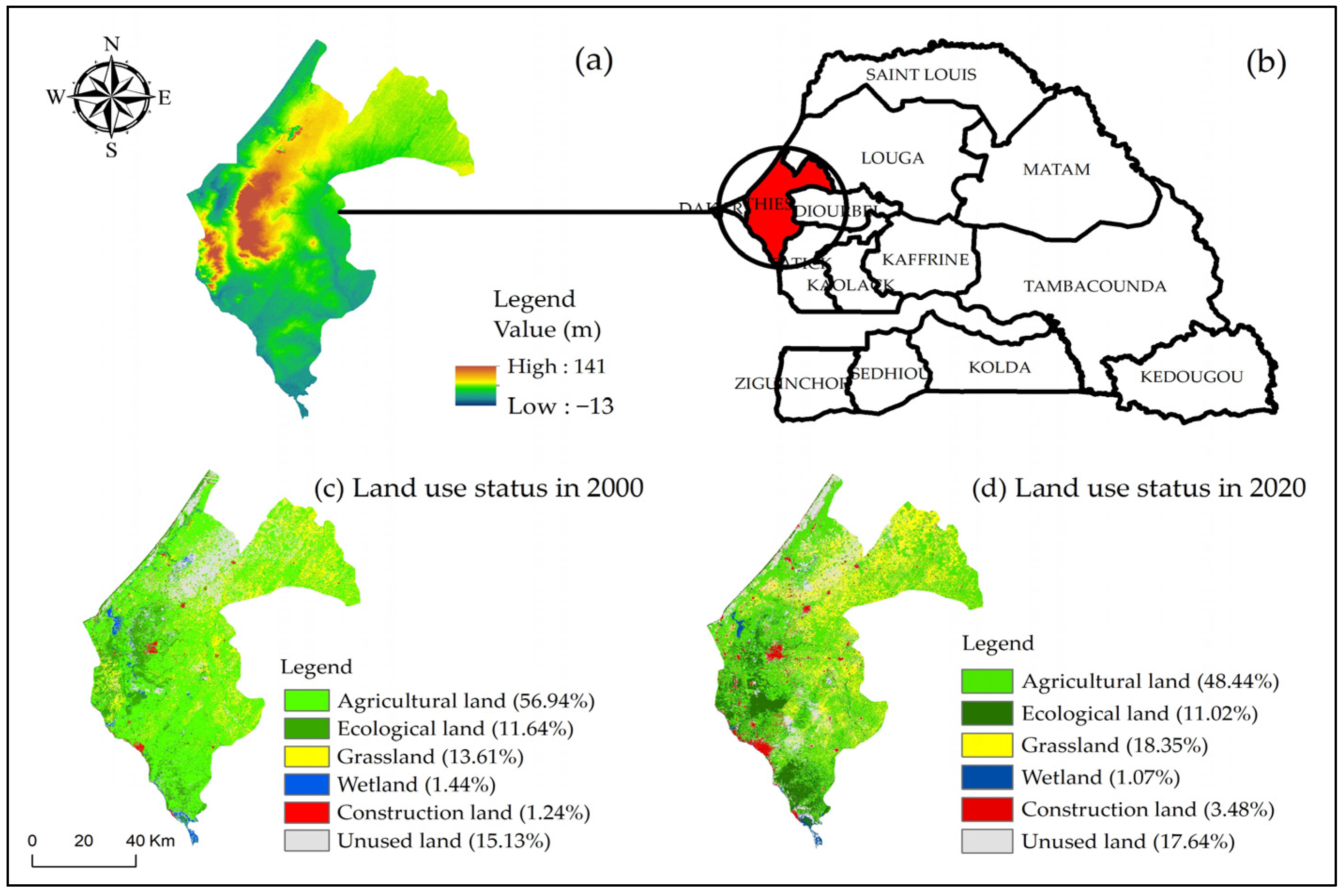
2. Presentation of the Thiès Region
3. Materials and Research Methodology
3.1. Data Sources
3.1.1. Remote Sensing Data
3.1.2. Social Survey Data
3.2. Research Methodology
3.2.1. Calculate the Method of Characterizing ALUT
- a.
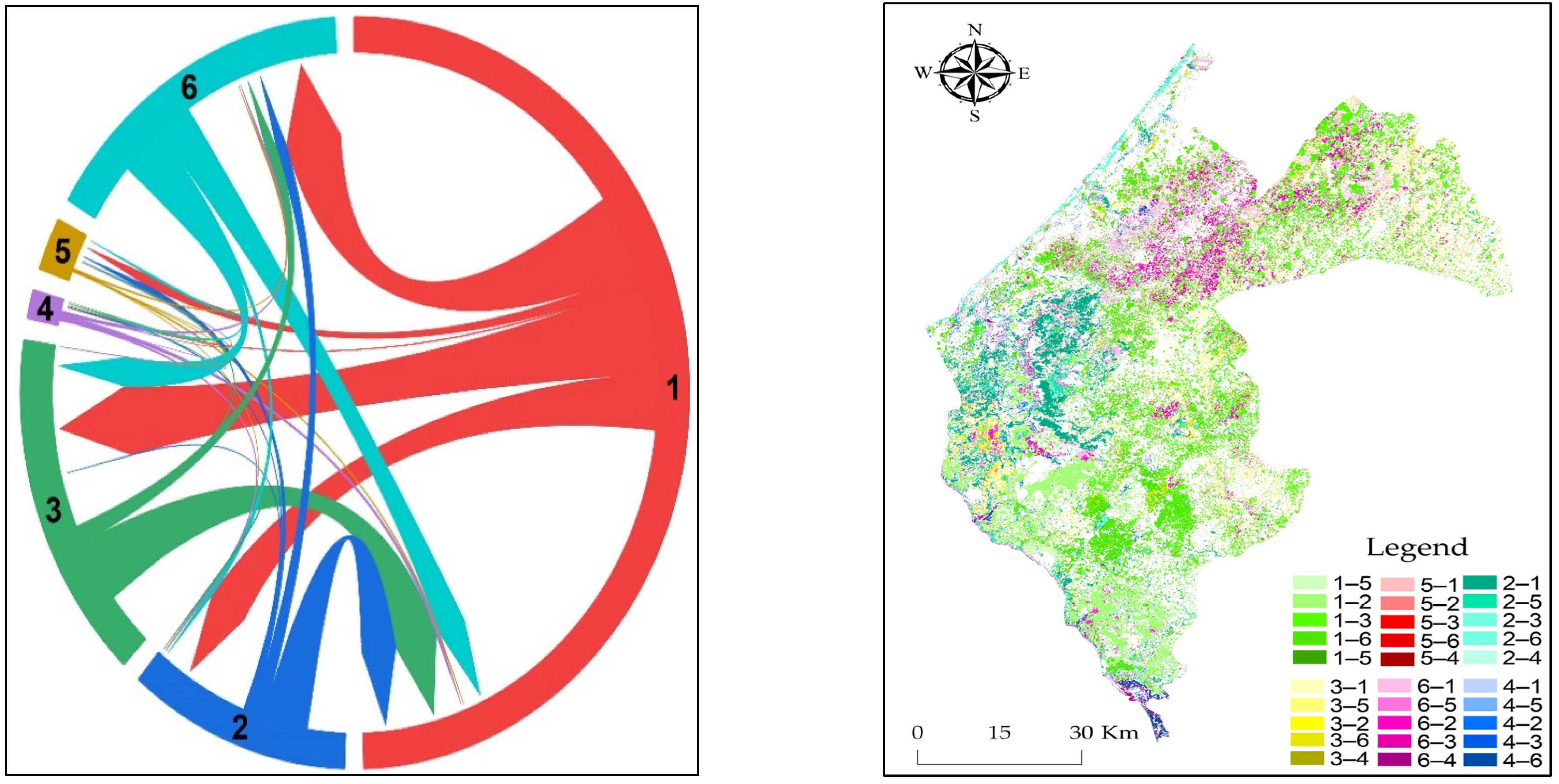
- Tracing the sources and flows of agricultural land use
- b.
- Kernel density estimation (KDE)
- c.
- Local spatial autocorrelation
3.2.2. Agricultural Land Morphology and Functions and Its Driving Factors
Determining Relevant Fundamental Influencing Factors
Determinate the Indexes of Agricultural land Functions
4. Results and Discussion
4.1. Spatial Distribution Characteristics of ALUT
4.1.1. Quantify the Net Transition of Agricultural Land Use
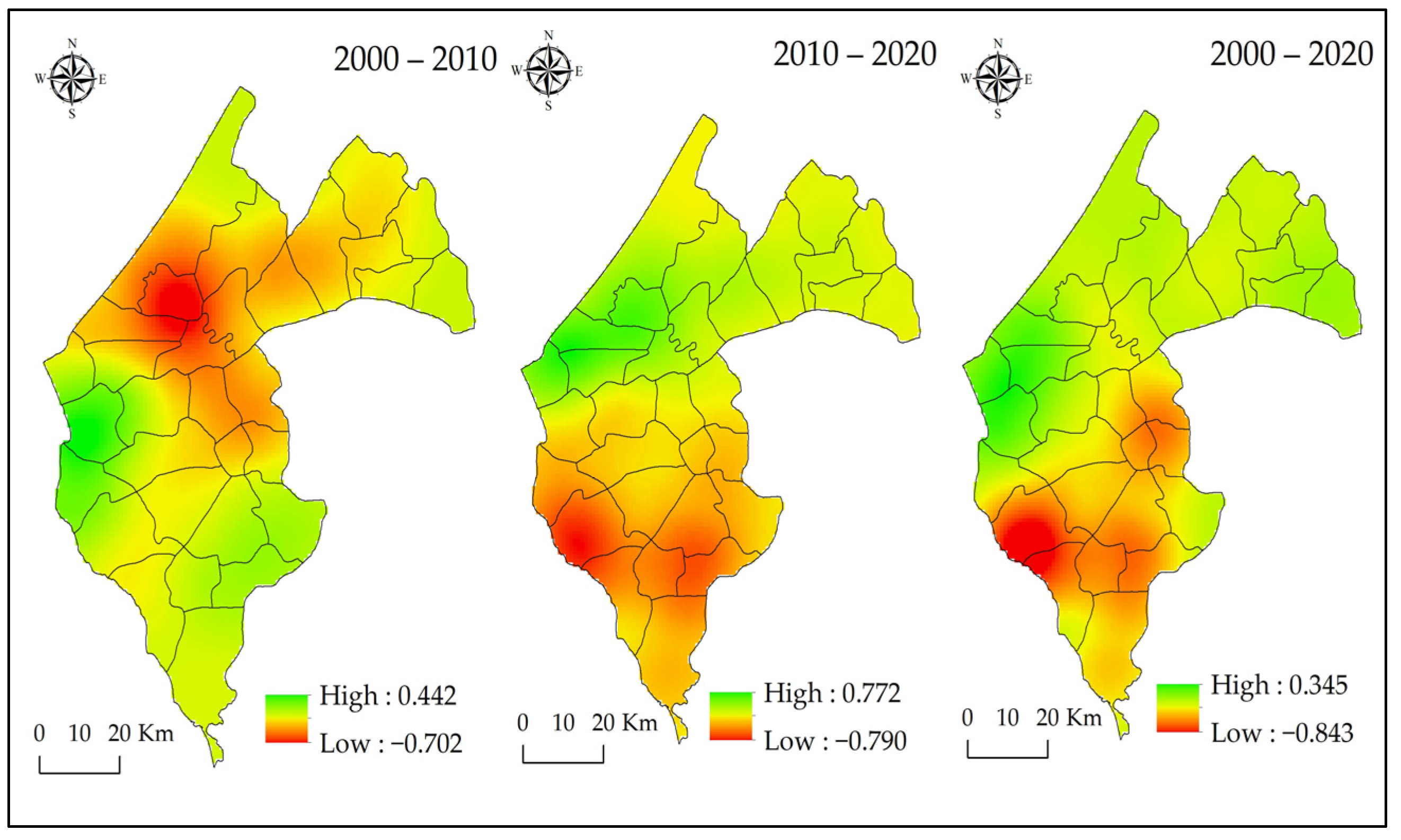
4.1.2. The Spatial Variation of the Nuclear Density of ALUT
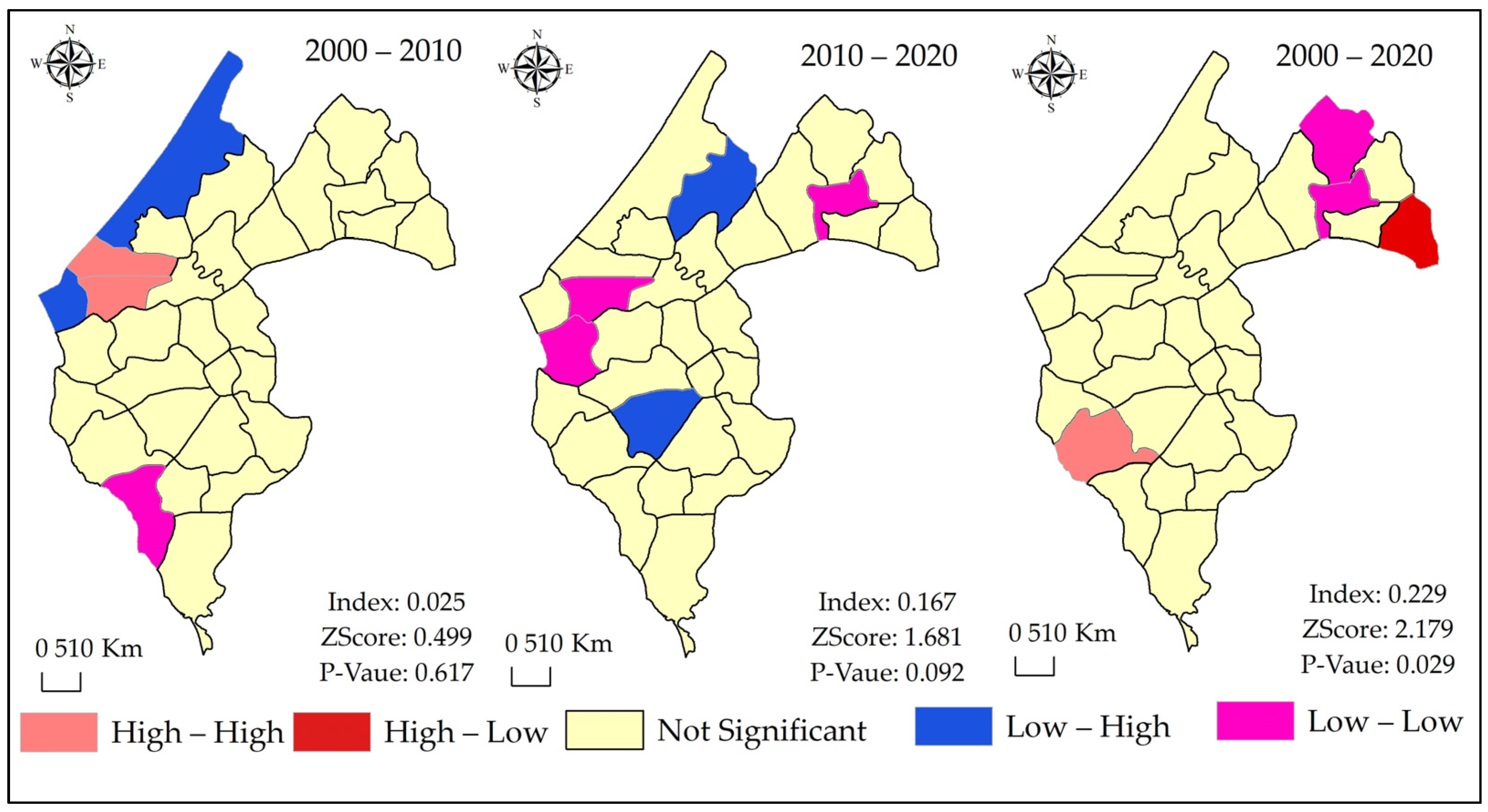
4.1.3. Local Spatial Autocorrelation Analysis
4.2. Exploring the Potential Influencing Factors of ALUT
4.2.1. Agricultural Land Morphology Change
4.2.2. Living Security Function
4.2.3. Eco-Environment Maintenance of Agricultural Land Function
4.3. The Contributions of the Study
4.4. Policy Implications
- (1)
- Rainfall variability directly reflects on the evolution of the sown land area. Therefore, different water systems must be mitigated and strengthened using suitable underground water while accounting for environmental issues. This integrated water use in agricultural production positively affected crop yield, increasing agricultural land functions—particularly per capita agricultural production.
- (2)
- In the Thiès region, about 81.37% of the respondents did not have formal documents. In this context, customary and modern land rights simultaneously govern land in Senegal. This situation induces many issues. On the one hand, land access became a source of conflict between government agencies regarding deliberation and, on the other hand, between users for their exploitation. Consequently, strong land reform policies in Senegal are urgent in light of the Thiès region’s worrying urbanization of agricultural land [43]. So, reforming land tenure must cooperate with its complexity rather than attempt to substitute customary land practices.
- (3)
- Cooperatives can also contribute to the strength of agricultural investment. Based on this potential, one of this study’s most important policy implications is that agricultural cooperatives should be generalized and integrated with small-scale farming households for maximum exploitation of agricultural land use. In Senegal, agriculture is still done traditionally [71,72,73,74,75,76], and technology use is almost non-existent. This study believes that improving agricultural infrastructures and enhancing agricultural input via cooperatives may positively impact agricultural production and farmers’ income, avoiding agricultural land abandonment.
- (4)
- The topography in the Thiès region is complex and diverse. This complexity induces erosion and soil salinization, affecting agricultural land use in the investigation area. The consequence of these degradations led to the evolution of different land utilization patterns and practices; therefore, agricultural land morphology needs a quantitative assessment of agricultural land degradation. Consequently, conducting land surveys using new technologies has become an urgent need to improve and combat land degradation to improve agricultural land conservation in Senegal.
4.5. Research Limitations and Prospects
5. Conclusions
Author Contributions
Funding
Institutional Review Board Statement
Informed Consent Statement
Data Availability Statement
Conflicts of Interest
References
- Marino, D.; Palmieri, M.; Marucci, A.; Soraci, M.; Barone, A.; Pili, S. Linking Flood Risk Mitigation and Food Security: An Analysis of Land-Use Change in the Metropolitan Area of Rome. Land 2023, 12, 366. [Google Scholar] [CrossRef]
- Faye, B.; Du, G.; Zhang, R. Efficiency Analysis of Land Use and the Degree of Coupling Link between Population Growth and Global Built-Up Area in the Subregion of West Africa. Land 2022, 11, 847. [Google Scholar] [CrossRef]
- Lambin, E.F.; Meyfroidt, P. Land use transitions: Socio-ecological feedback versus socio-economic change. Land Use Policy 2010, 27, 108–118. [Google Scholar] [CrossRef]
- Paul, B.K.; Rashid, H. Land Use Change and Coastal Management. In Climatic Hazards in Coastal Bangladesh; Elsevier: Kidlington, UK, 2017; pp. 183–207. [Google Scholar]
- Ustaoglu, E.; Williams, B. Determinants of Urban Expansion and Agricultural Land Conversion in 25 EU Countries. Environ. Manag. 2017, 60, 717–746. [Google Scholar] [CrossRef] [PubMed]
- Faye, B.; Du, G. Agricultural Land Transition in the “Groundnut Basin” of Senegal: 2009 to 2018. Land 2021, 10, 996. [Google Scholar] [CrossRef]
- Ndong. The evolution of rainfall in Senegal and the consequences of the recent drought on the environment (French). Rev. Géographie Lyon 1995, 70, 193–198. [Google Scholar] [CrossRef]
- Leidinger, J.L.G.; Gossner, M.M.; Weisser, W.W.; Koch, C.; Rosadio Cayllahua, Z.L.; Podgaiski, L.R.; Duarte, M.M.; Araújo, A.S.F.; Overbeck, G.E.; Hermann, J.-M.; et al. Historical and recent land use affects ecosystem functions in subtropical grasslands in Brazil. Ecosphere 2017, 8, e02032. [Google Scholar] [CrossRef] [Green Version]
- Kuchimanchi, B.R.; De Boer, I.J.M.; Ripoll-Bosch, R.; Oosting, S.J. Understanding transitions in farming systems and their effects on livestock rearing and smallholder livelihoods in Telangana, India. Ambio 2021, 50, 1809–1823. [Google Scholar] [CrossRef]
- Chen, C.; He, X.; Liu, Z.; Sun, W.; Dong, H.; Chu, Y. Analysis of regional economic development based on land use and land cover change information derived from Landsat imagery. Sci. Rep. 2020, 10, 12721. [Google Scholar] [CrossRef]
- Kobayashi, Y.; Higa, M.; Higashiyama, K.; Nakamura, F. Drivers of land-use changes in societies with decreasing populations: A comparison of the factors affecting farmland abandonment in a food production area in Japan. PLoS ONE 2020, 15, e0235846. [Google Scholar] [CrossRef]
- Omasire, A.K.; Kimondiu, J.M.; Kariuki, P. Urban Sprawl Causes and Impacts on Agricultural Land in Wote Town Area of Makueni County, Kenya. Int. J. Environ. Agric. Biotechnol. 2020, 5, 631–635. [Google Scholar] [CrossRef]
- Gardi, C.; Panagos, P.; Van Liedekerke, M.; Bosco, C.; De Brogniez, D. Land take and food security: Assessment of land take on the agricultural production in Europe. J. Environ. Plan. Manag. 2015, 58, 898–912. [Google Scholar] [CrossRef]
- Reseau Agro-Innov. Voluntary Cooperation Program for Innovative and Sustainable Agricultural Entrepreneurship Senegal Portrait-Diagnosis of Agricultural Soil Health (French). 2017. Available online: https://docplayer.fr/158367777-Programme-de-cooperation-volontaire-pour-un-entrepreneuriat-agricole-innovant-et-durable-senegal-portrait-diagnostic-de-la-sante-des-sols-agricoles.html (accessed on 30 April 2021).
- Liu, Y.; Yang, R.; Long, H.; Gao, J.; Wang, J. Implications of land-use change in rural China: A case study of Yucheng, Shandong province. Land Use Policy 2014, 40, 111–118. [Google Scholar] [CrossRef]
- Vanbergen, A.J.; Aizen, M.A.; Cordeau, S.; Garibaldi, L.A.; Garratt, M.P.; Kovács-Hostyánszki, A.; Lecuyer, L.; Ngo, H.T.; Potts, S.G.; Settele, J.; et al. Transformation of agricultural landscapes in the Anthropocene: Nature’s contributions to people, agriculture and food security. In Advances in Ecological Research; Academic Press Inc.: Cambridge, MA, USA, 2020; Volume 63, pp. 193–253. ISBN 9780128220177. [Google Scholar] [CrossRef]
- Lyu, L.; Gao, Z.; Long, H.; Wang, X.; Fan, Y. Farmland Use Transition in a Typical Farming Area: The Case of Sihong County in the Huang-Huai-Hai Plain of China. Land 2021, 10, 347. [Google Scholar] [CrossRef]
- Wang, J.-L.; Liu, B.; Zhou, T. The category identification and transformation mechanism of rural regional function based on SOFM model: A case study of Central Plains Urban Agglomeration, China. Ecol. Indic. 2023, 147, 109926. [Google Scholar] [CrossRef]
- Nijbroek, R.P.; Andelman, S.J. Regional suitability for agricultural intensification: A spatial analysis of the Southern Agricultural Growth Corridor of Tanzania. Int. J. Agric. Sustain. 2016, 14, 231–247. [Google Scholar] [CrossRef] [Green Version]
- Abdoulaye, S. Fertilizer Subsidy and Agricultural Productivity in Senegal. AGRODEP. 2016. Available online: https://www.researchgate.net/publication/301658995_Fertilizer_Subsidy_and_Agricultural_Productivity_in_Senegal?channel=doi&linkId=572081b308aead26e71bb414&showFulltext=true (accessed on 19 January 2023).
- Huan, M.; Zhan, S. Agricultural Production Services, Farm Size and Chemical Fertilizer Use in China’s Maize Production. Land 2022, 11, 1931. [Google Scholar] [CrossRef]
- Faye, B. Analysis of the Problems of the Agricultural Sector in the Face of Rainfall Variability in the Commune of Dara Mboss, Kaolack Region from 1980 to 2014. Master in Geography. Master’s Thesis, Cheikh Anta Diop University of Dakar, Senegal, France, 2016. [Google Scholar]
- Yang, Z.; Shen, N.; Qu, Y.; Zhang, B. Association between Rural Land Use Transition and Urban–Rural Integration Development: From 2009 to 2018 Based on County-Level Data in Shandong Province, China. Land 2021, 10, 1228. [Google Scholar] [CrossRef]
- Cao, W.; Zhou, S.; Zhou, M. Operational Pattern of Urban-Rural Integration Regulated by Land Use in Metropolitan Fringe of China. Land 2021, 10, 515. [Google Scholar] [CrossRef]
- Alam, G.M.; Khatun, M.N.; Sarker, M.N.I.; Joshi, N.P.; Bhandari, H. Promoting agri-food systems resilience through ICT in developing countries amid COVID-19. Front. Sustain. Food Syst. 2023, 6, 672. [Google Scholar] [CrossRef]
- Faye, M.; Fall, A.; Faye, G.; Van Hecke, E. Rainfall variability and its impacts on agricultural yields in the New Land area (Eastern Senegal). Belgeo 2018. [Google Scholar] [CrossRef] [Green Version]
- Tappan, G.; Sall, M.; Wood, E.; Cushing, M. Ecoregions and land cover trends in Senegal. J. Arid Environ. 2004, 59, 427–462. [Google Scholar] [CrossRef]
- Ecological Monitoring Centre. Annuaire sur l’Environnement et les Ressources Naturelles au Seneal, 4th ed.; Ecological Monitoring Centre: Dakar, Senegal, 2018; pp. 12–19. Available online: https://www.cse.sn/index.php (accessed on 28 August 2021).
- Sagna, P.; Ndiaye, O.; Diop, C.; Niang, A.; Sambou, P. Are recent climate variations observed in Senegal in conformity with the descriptions given by the IPCC scenarios? Pollut. Atmos. 2015, 227, 17. [Google Scholar] [CrossRef] [Green Version]
- Teferi, E.; Bewket, W.; Uhlenbrook, S.; Wenninger, J. Understanding recent land use and land cover dynamics in the source region of the Upper Blue Nile, Ethiopia: Spatially explicit statistical modeling of systematic transitions. Agric. Ecosyst. Environ. 2013, 165, 98–117. [Google Scholar] [CrossRef]
- Díaz-Pacheco, J.; Van Delden, H.; Hewitt, R. The Importance of Scale in Land Use Models: Experiments in Data Conversion, Data Resampling, Resolution and Neighborhood Extent. In Geomatic Approaches for Modeling Land Change Scenarios; Springer: Cham, Switzerland, 2018; pp. 163–186. [Google Scholar] [CrossRef]
- Briassoulis, H. Analysis of Land Use Change: Theoretical and Modeling Approaches Table of Contents; West Virginia University: Morgantown, WV, USA, 2020; pp. 4–6. Available online: https://researchrepository.wvu.edu/rri-web-book (accessed on 22 March 2023).
- Anderson, J.R. A Land Use and Land Cover Classification System for Use with Remote Sensor Data; United States Government Printing Office: Washington, DC, USA, 1976.
- Islami, F.A.; Tarigan, S.D.; Wahjunie, E.D.; Dasanto, B.D. Accuracy Assessment of Land Use Change Analysis Using Google Earth in Sadar Watershed Mojokerto Regency. IOP Conf. Ser. Earth Environ. Sci. 2022, 950, 012091. [Google Scholar] [CrossRef]
- Pontius, R.G.; Boersma, W.; Castella, J.C.; Clarke, K.; Nijs, T.; Dietzel, C.; Duan, Z.; Fotsing, E.; Goldstein, N.; Kok, K.; et al. Comparing the input, output, and validation maps for several models of land change. Ann. Reg. Sci. 2008, 42, 11–37. [Google Scholar] [CrossRef] [Green Version]
- Kumar Sathees, R.N.M.S. Land use change modelling using a Markov model and remote sensing. Geomat. Nat. Hazards Risk 2014, 5, 145–156. [Google Scholar] [CrossRef]
- Wang, J.; Wang, X.; Du, G.; Zhang, H. Temporal and Spatial Changes of Rural Settlements and Their Influencing Factors in Northeast China from 2000 to 2020. Land 2022, 11, 1640. [Google Scholar] [CrossRef]
- Zhang, B.; Zhang, Q.; Feng, C.; Feng, Q.; Zhang, S. Understanding Land Use and Land Cover Dynamics from 1976 to 2014 in Yellow River Delta. Land 2017, 6, 20. [Google Scholar] [CrossRef] [Green Version]
- Mohamed, A.; Worku, H. Quantification of the land use/land cover dynamics and the degree of urban growth goodness for sustainable urban land use planning in Addis Ababa and the surrounding Oromia special zone. J. Urban Manag. 2019, 8, 145–158. [Google Scholar] [CrossRef]
- Li, Q.; Liu, W.; Du, G.; Faye, B.; Wang, H.; Li, Y.; Wang, L.; Qu, S. Spatiotemporal Evolution of Crop Planting Structure in the Black Soil Region of Northeast China: A Case Study in Hailun County. Land 2022, 11, 785. [Google Scholar] [CrossRef]
- Home, R. History and Prospects for African Land Governance: Institutions, Technology and ‘Land Rights for All’. Land 2021, 10, 292. [Google Scholar] [CrossRef]
- Xian, S.; Li, L.; Qi, Z. Toward a sustainable urban expansion: A case study of Zhuhai, China. J. Clean. Prod. 2019, 230, 276–285. [Google Scholar] [CrossRef]
- Long, H.; Zhang, Y.; Ma, L.; Tu, S. Land Use Transitions: Progress, Challenges and Prospects. Land 2021, 10, 903. [Google Scholar] [CrossRef]
- World Meteorological Organization. Climate and Land Degradation; World Meteorological Organization: Geneva, Switzerland, 2005; ISBN 9263109893. [Google Scholar]
- Prishchepov, A.V. Agricultural Land Abandonment. In Environmental Science; Oxford University Press: Oxford, UK, 2020. [Google Scholar]
- Georges, N.; Fang, S.; Beckline, M.; Wu, Y. Potentials of the Groundnut Sector towards Achieving Food Security in Senegal. OALib 2016, 3, 1–13. [Google Scholar] [CrossRef]
- Xu, T.; Chen, H.; Ji, Y.; Qiao, D.; Wang, F. Understanding the differences in cultivated land protection behaviors between smallholders and professional farmers in Hainan Province, China. Front. Sustain. Food Syst. 2023, 7, 1081671. [Google Scholar] [CrossRef]
- Xu, K.; Zhou, J.; Lei, Q.; Wu, W.; Mao, G. Effect of Agricultural Structure Adjustment on Spatio-Temporal Patterns of Net Anthropogenic Nitrogen Inputs in the Pearl River Basin from 1990 to 2019. Land 2023, 12, 311. [Google Scholar] [CrossRef]
- Wang, B.; Liang, Y.; Peng, S. Harnessing the indirect effect of urban expansion for mitigating agriculture-environment trade-offs in the Loess Plateau. Land Use Policy 2022, 122, 106395. [Google Scholar] [CrossRef]
- Tang, L.; Kan, Z.; Zhang, X.; Sun, F.; Yang, X.; Li, Q. A network Kernel Density Estimation for linear features in space–time analysis of big trace data. Int. J. Geogr. Inf. Sci. 2016, 30, 1717–1737. [Google Scholar] [CrossRef]
- Satterthwaite, D.; McGranahan, G.; Tacoli, C. Urbanization and its implications for food and farming. Philos. Trans. R. Soc. B Biol. Sci. 2010, 365, 2809–2820. [Google Scholar] [CrossRef]
- Beckers, V.; Poelmans, L.; Van Rompaey, A.; Dendoncker, N. The impact of urbanization on agricultural dynamics: A case study in Belgium. J. Land Use Sci. 2020, 15, 626–643. [Google Scholar] [CrossRef]
- Mane, M. The urban centers of the Dakar—Thies—Mbour triangle and social housing policy—ACRESA. 2021. Available online: https://acresa.org/les-poles-urbains-du-triangle-dakar-thies-mbour-et-la-politique-du-logement-social (accessed on 29 January 2023).
- Dubé, J.; Legros, D. Spatial Autocorrelation. In Spatial Econometrics Using Microdata; John Wiley & Sons, Inc.: Hoboken, NJ, USA, 2014; pp. 59–91. [Google Scholar]
- Ondiek, R.A.; Vuolo, F.; Kipkemboi, J.; Kitaka, N.; Lautsch, E.; Hein, T.; Schmid, E. Socio-Economic Determinants of Land Use/Cover Change in Wetlands in East Africa: A Case Study Analysis of the Anyiko Wetland, Kenya. Front. Environ. Sci. 2020, 7, 207. [Google Scholar] [CrossRef]
- Seck, H.M.; Dièye, E.H.B.; Solly, B. Mining and socio-economic consequences in river local authorities: Example of theChemical Industries of Senegal (ICS). Afr. Sci. 2021, 19, 93–105. Available online: https://www.researchgate.net/publication/358351421_Extraction_miniere_et_consequences_socio-economiques_dans_les_collectivites_locales_riveraines_exemple_des_industries_chimiques_du_Senegal_ICS (accessed on 15 January 2023).
- Zhang, Y.; Long, H.; Tu, S.; Ge, D.; Ma, L.; Wang, L. Spatial identification of land use functions and their tradeoffs/synergies in China: Implications for sustainable land management. Ecol. Indic. 2019, 107, 105550. [Google Scholar] [CrossRef]
- Francis, C.A.; Hansen, T.E.; Fox, A.A.; Hesje, P.J.; Nelson, H.E.; Lawseth, A.E.; English, A. Farmland conversion to non-agricultural uses in the US and Canada: Current impacts and concerns for the future. Int. J. Agric. Sustain. 2012, 10, 8–24. [Google Scholar] [CrossRef]
- Ranganathan, J.; Vennard, D.; Waite, R.; Lipinski, B.; Searchinger, T.; Dumas, P. Shifting Diets for a Sustainable Food Future; Working Paper, Installment 11 of Creating a Sustainable Food Future; World Resources Institute: Washington, DC, USA, 2016; Available online: http://www.worldresourcesreport.org (accessed on 27 May 2022).
- Chen, H.; Zhang, W.; Gao, H.; Nie, N. Climate Change and Anthropogenic Impacts on Wetland and Agriculture in the Songnen and Sanjiang Plain, Northeast China. Remote Sens. 2018, 10, 356. [Google Scholar] [CrossRef] [Green Version]
- Roy, J.; Bose, C.; Bose, R.; Das, S.; Dhakal, S.; Dasgupta, M.; Rucha, G.; Roy, S.S.; Konar, M.; Wickramasinghe, A.; et al. Development Pathway. In Global Environmental Changes in South Asia; Springer: Berlin/Heidelberg, Germany, 2010; pp. 14–53. [Google Scholar] [CrossRef]
- Zhao, Q.; Wen, Z.; Chen, S.; Ding, S.; Zhang, M. Quantifying land use/land cover and landscape pattern changes and impacts on ecosystem services. Int. J. Environ. Res. Public Health 2020, 17, 126. [Google Scholar] [CrossRef] [Green Version]
- Prishchepov, A.A.; Müller, D.; Dubinin, M.; Baumann, M.; Radeloff, V.C. Determinants of agricultural land abandonment in post-Soviet European Russia. Land Use Policy 2013, 30, 873–884. [Google Scholar] [CrossRef] [Green Version]
- Seck, A. Heterogeneous credit constraints and smallholder farming productivity in the Senegal River Valley. Emerg. Mark. Financ. Trade 2021, 57, 3301–3319. [Google Scholar] [CrossRef]
- Ariom, T.O.; Dimon, E.; Nambeye, E.; Diouf, N.S.; Adelusi, O.O.; Boudalia, S. Climate-Smart Agriculture in African Countries: A Review of Strategies and Impacts on Smallholder Farmers. Sustainability 2022, 14, 11370. [Google Scholar] [CrossRef]
- Liu, S.; Wang, B. The decline in agricultural share and agricultural industrialization—Some stylized facts and theoretical explanations. China Agric. Econ. Rev. 2022, 14, 469–493. [Google Scholar] [CrossRef]
- Mbengue, G.S. Impact of Rainfall Variability on Agricultural Production in the Commune of Mont Rolland 1950 to 2000; Master in Geography, Cheikh Anta Diop University of Dakar: Dakar, Senegal, 2007; pp. 1–157. [Google Scholar]
- Abdulraheem, M.I.; Adefare, T.E.; Okpakhalu, L.D.; Iderawumi, M.A.; Ajetunmobi-Adeyeye, R.I.; Oyetoro, B.A.; Moshood, A.Y.; Akume, T.; Oluwaseun, W.A.; Obene, S.A. Impact of Transportation on Agricultural Practices and Production in Rural Areas: Implication for Sustainable Food Security. Biomed. J. Sci. Technol. Res. 2021, 35, 27475–27479. [Google Scholar] [CrossRef]
- Gaye, L.; Sène, L.; Stads, G.J. Agricultural R&D in Senegal: An Assessment of the Senegalese Agricultural Research Institute|IFPRI: International Food Policy Research Institute. International Food Policy Research Institue. 2014. Available online: https://www.ifpri.org/publication/agricultural-rd-senegal-assessment-senegalese-agricultural-research-institute (accessed on 25 January 2023).
- Liu, J.; Zeng, S.; Ma, J.; Chang, Y.; Sun, Y.; Chen, F. The Impacts of Rapid Urbanization on Farmland Marginalization: A Case Study of the Yangtze River Delta, China. Agriculture 2022, 12, 1276. [Google Scholar] [CrossRef]
- Lin, W.; Lin, M.; Zhou, H.; Wu, H.; Li, Z.; Lin, W. The effects of chemical and organic fertilizer usage on rhizosphere soil in tea orchards. PLoS ONE 2019, 14, e0217018. [Google Scholar] [CrossRef] [PubMed]
- Haddaway, N.R.; Styles, D.; Pullin, A.S. Environmental impacts of farm land abandonment in high altitude/mountain regions: A systematic map of the evidence. Environ. Evid. 2013, 2, 18. [Google Scholar] [CrossRef] [Green Version]
- Reganold, J.P.; Jackson-Smith, D.; Batie, S.S.; Harwood, R.R.; Kornegay, J.L.; Bucks, D.; Flora, C.B.; Hanson, J.C.; Jury, W.A.; Meyer, D.; et al. Transforming U.S. agriculture. Science 2011, 332, 670–671. [Google Scholar] [CrossRef]
- Krawchenko, T.; Tomaney, J. The Governance of Land Use: A Conceptual Framework. Land 2023, 12, 608. [Google Scholar] [CrossRef]
- Nasiakou, S.; Vrahnakis, M.; Chouvardas, D.; Mamanis, G.; Kleftoyanni, V. Land Use Changes for Investments in Silvoarable Agriculture Projected by the CLUE-S Spatio-Temporal Model. Land 2022, 11, 598. [Google Scholar] [CrossRef]
- Fami, H.S.; Ghasemi, J.; Malekipoor, R.; Rashidi, P.; Nazari, S.; Mirzaee, A. Renewable Energy Use in Smallholder Farming Systems: A Case Study in Tafresh Township of Iran. Sustainability 2010, 2, 702–716. [Google Scholar] [CrossRef] [Green Version]


| Acquisition Date | Image Types | WRS Path/Row | Proportion of Cloud % | Collected Date | |
|---|---|---|---|---|---|
| 2000 | 11 November | Landsat 7 ETM + C1-L1 | 205/50 | 1 | 31 August 2022 |
| 11 November | Landsat 7 ETM + C1 | 205/49 | 7 | 31 August 2022 | |
| 2010 | 25 October | Landsat 5 TM C2-L1 | 205/50 | 0 | 6 July 2022 |
| 25 October | Landsat 5 TM C2-L1 | 205/49 | 6 | 6 July 2022 | |
| 2020 | 20 October | Landsat 8 OLI-C2-L1 | 205/50 | 1.94 | 22 August 2022 |
| 20 October | Landsat 8 OLI-C2-L1 | 205/49 | 1.35 | 22 August 2022 |
| Time 2 (T2) | A + i | Loss in Land Area | |||||
|---|---|---|---|---|---|---|---|
| Time 1 (T1) | L1 | L2 | … | Ln | |||
| L1 | A11 | A12 | … | A1n | A1+ | A1+–A11 | |
| L2 | A21 | A22 | … | A2n | A2+ | A2+–A22 | |
| … | … | … | … | … | … | … | |
| Ln | An1 | An2 | … | Ann | An+ | An+–Ann | |
| A + i | A + 1 | A + 2 | … | A + n | |||
| Gain in land area | A + 1–A11 | A + 2–A22 | … | A + n–Ann | |||
| N. | Variables | Main Score Values (%) | Coding |
|---|---|---|---|
| 1 | Population growth | With score 2 = 52.48% | 1 = strongly agree; 2 = agree; 3 = neutral; 4 = disagree; and 5 = strongly disagree |
| 2 | Transportation facilities | With score 2 = 48.38% | |
| 3 | Farmers’ labor force | With score 2 = 56.41% | |
| 4 | Lack of agricultural investment | With score 2 = 62.91% | |
| 5 | Rainfall variability | With score 2 = 54.87% | |
| 6 | Wind erosion | With score 2 = 54.53% | |
| 7 | Soil salinization | With score 2 = 58.46% | |
| 8 | Hydric erosion | With score 2 = 58.63% | |
| 9 | Research and development | With score 2 = 32.82% | |
| 10 | Number of plots had a formal document | With score 2 = 81.37% | 1 = yes, 2 = no |
| N | First Level | Second Level | Unit | Description and Calculation Method | Average/ Percentage |
|---|---|---|---|---|---|
| 1 | Agricultural land morphology | Sown land status | Frequency | Respondent’s land area where diminish | 76.07% |
| Land abandonment status | Frequency | Respondents have abandoned plots of land | 42.05% | ||
| 2 | Living security function | Agricultural land per capita | ha/pers | Total sown land area reported to the family size | 0.37 |
| Agricultural income per capita | USA$ | Total income reported to the family size (1 USD = 617,50 XOF 12/12/2022) | 167.18 | ||
| 3 | Eco-environmental aspects maintain the agricultural land’s function | Situation or the level of agricultural land conservation | Frequency | The number of farmers who have used any method of fighting against agricultural land degradation | 55.38% |
| The intense use of fertilizer | Frequency | Number of farmers using fertilizer regularly for production | 59.49% |
| Land Use Types in 2020 | ||||||||
|---|---|---|---|---|---|---|---|---|
| Land Use Types in 2000 | Agricultural Land | Construction Land | Ecological Land | Grass Land | Unused Land | Wet Land | Total—2000 | Loss |
| Agricultural land | 2178.49 | 87.18 | 380.81 | 601.80 | 540.17 | 8.82 | 3797.27 | 1618.7 |
| Construction land | 10.44 | 59.68 | 1.14 | 1.91 | 9.46 | 0.24 | 82.87 | 23.19 |
| Ecological land | 335.48 | 47.29 | 282.26 | 5.26 | 98.77 | 6.94 | 776.00 | 493.75 |
| Grassland | 411.70 | 14.95 | 16.73 | 360.66 | 102.51 | 1.25 | 907.81 | 547.15 |
| Unused land | 266.79 | 20.58 | 40.35 | 253.86 | 403.56 | 23.57 | 1008.71 | 605.14 |
| Wetland | 27.57 | 2.14 | 13.71 | 0.23 | 21.74 | 30.46 | 95.85 | 65.38 |
| Total—2020 | 3230.48 | 231.82 | 734.99 | 1223.71 | 1176.21 | 71.29 | 6669.51 | |
| Gain | 1051.98 | 172.14 | 452.73 | 863.05 | 772.65 | 40.82 | x | x |
| Total shift | −566.80 | 148.95 | −41.01 | 315.90 | 167.51 | −55.02 | x | x |
| Spatial index (%) | −8.498 | 2.233 | −0.615 | 4.736 | 2.512 | −0.368 | x | x |
| Agricultural Land Morphology Change | Living Security Function | Eco-Environment Maintenance Agricultural Land Function | |||||
|---|---|---|---|---|---|---|---|
| Level I | Level II | Sown land Evolution | Agricultural land abandon | Agricultural land per capita | Farmer income per capita | Agricultural conservation level | Agricultural fertilizers used frequently |
| (Intercept) | 000000 *** | 000000 *** | 000000 *** | 0.000001 *** | 000000 *** | 0.000002 *** | |
| Socio-economic driving factors | PG | 0.050148 * | 0.782446 | 0.924369 | 0.949626 | 0.18602 | 0.537107 |
| TF | 0.000386 *** | 0.072803 * | 0.152944 | 0.041487 ** | 0.054434 * | 0.014309 ** | |
| FLF | 0.014133 ** | 0.675247 | 0.304713 | 0.869623 | 0.015784 ** | 0.073276 * | |
| AI | 0.066225 * | 0.002438 *** | 0.275338 | 0.373963 | 0.009217 *** | 0.969148 | |
| Natural and climatic driving factors | RV | 0.005602 *** | 0.052266 * | 0.000241 *** | 0.000002 *** | 0.389152 | 000000 *** |
| WE | 0.992705 | 0.783634 | 0.599841 | 0.898509 | 0.003984 *** | 0.330631 | |
| SS | 0.003655 *** | 0.008956 *** | 0.492751 | 0.625101 | 000000 *** | 0.018829 ** | |
| HE | 0.555487 | 0.328227 | 0.636611 | 0.584647 | 0.021972 ** | 0.378208 | |
| Political driving factors | RD | 0.014066 ** | 000000 *** | 0.212554 | 0.821024 | 000000 *** | 0.000001 *** |
| LT | 0.000007 *** | 0.029396 ** | 0.907655 | 0.264722 | 000000 *** | 0.04812 ** | |
| Num.Obs. | 585 | 585 | 585 | 585 | 585 | 585 | |
| R2 | 0.144439 | 0.188411 | 0.05354 | 0.063436 | 0.340459 | 0.203325 | |
| R2 Adj. | 0.129534 | 0.174272 | 0.037051 | 0.047119 | 0.328968 | 0.189446 | |
| Sigma error | 0.525725 | 0.448954 | 0.041876 | 139.004495 | 0.804081 | 0.442354 | |
| F-Test (10,574) | 9.6905 (0.000000) | 13.3255 (0.000000) | 3.2471 (0.000432) | 3.8878 (0.000040) | 29.6302 (0.000000) | 14.6495 (0.000000) | |
Disclaimer/Publisher’s Note: The statements, opinions and data contained in all publications are solely those of the individual author(s) and contributor(s) and not of MDPI and/or the editor(s). MDPI and/or the editor(s) disclaim responsibility for any injury to people or property resulting from any ideas, methods, instructions or products referred to in the content. |
© 2023 by the authors. Licensee MDPI, Basel, Switzerland. This article is an open access article distributed under the terms and conditions of the Creative Commons Attribution (CC BY) license (https://creativecommons.org/licenses/by/4.0/).
Share and Cite
Faye, B.; Du, G.; Mbaye, E.; Liang, C.; Sané, T.; Xue, R. Assessing the Spatial Agricultural Land Use Transition in Thiès Region, Senegal, and Its Potential Driving Factors. Land 2023, 12, 779. https://doi.org/10.3390/land12040779
Faye B, Du G, Mbaye E, Liang C, Sané T, Xue R. Assessing the Spatial Agricultural Land Use Transition in Thiès Region, Senegal, and Its Potential Driving Factors. Land. 2023; 12(4):779. https://doi.org/10.3390/land12040779
Chicago/Turabian StyleFaye, Bonoua, Guoming Du, Edmée Mbaye, Chang’an Liang, Tidiane Sané, and Ruhao Xue. 2023. "Assessing the Spatial Agricultural Land Use Transition in Thiès Region, Senegal, and Its Potential Driving Factors" Land 12, no. 4: 779. https://doi.org/10.3390/land12040779