

The Urban Public Space between Land and Sea: The Case of Quarteira, Portugal
 ,
,  , and
, and 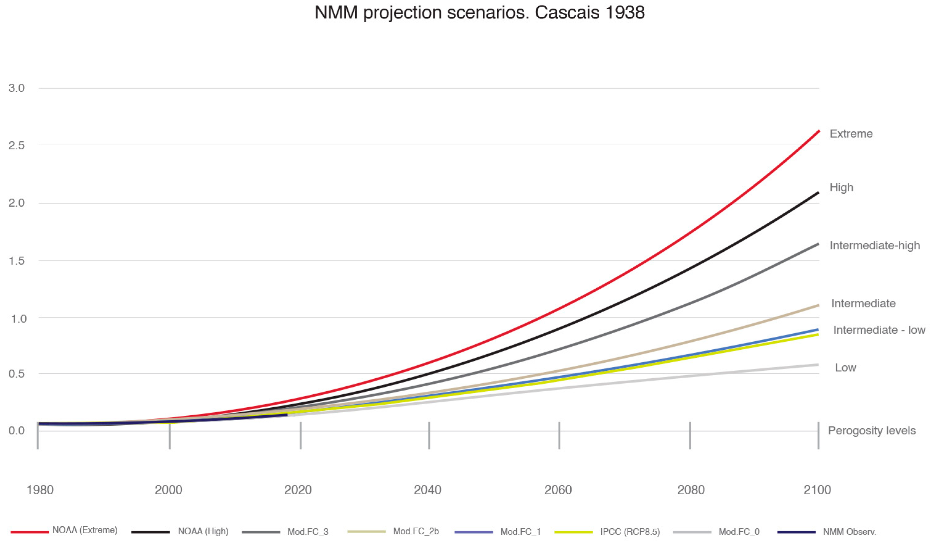
Abstract
:1. Introduction
2. Coastal Urban Settlements Vulnerable to Mean Sea Level Rise
2.1. Effects of the Rise in Mean Sea Level on the Portuguese Coast
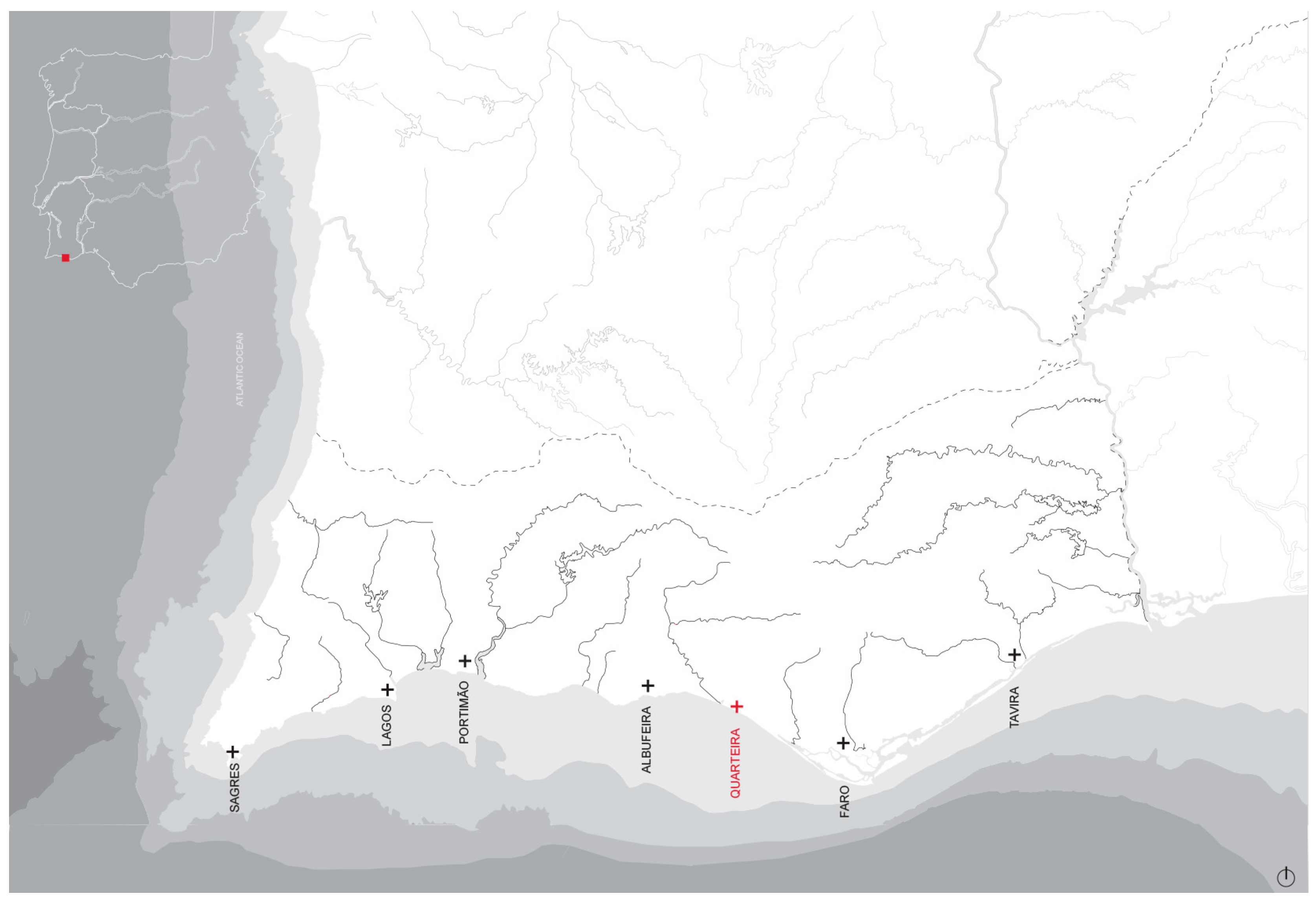
2.2. Coastal Urban Settlements in Portugal
3. Method
3.1. Data Acquisition
3.2. Decoding the Urban form Vulnerable to Mean Sea Level Rise
4. Results
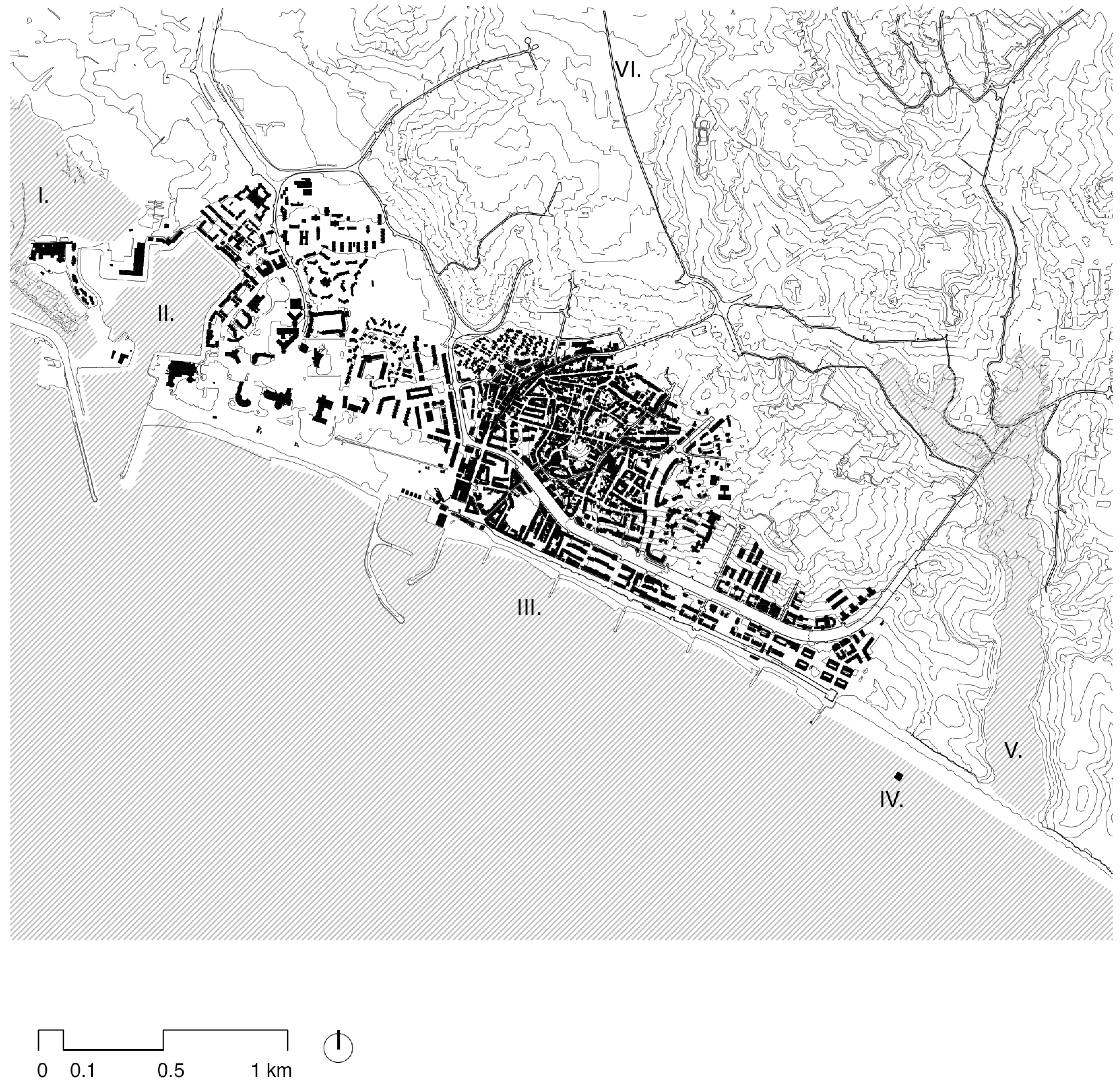
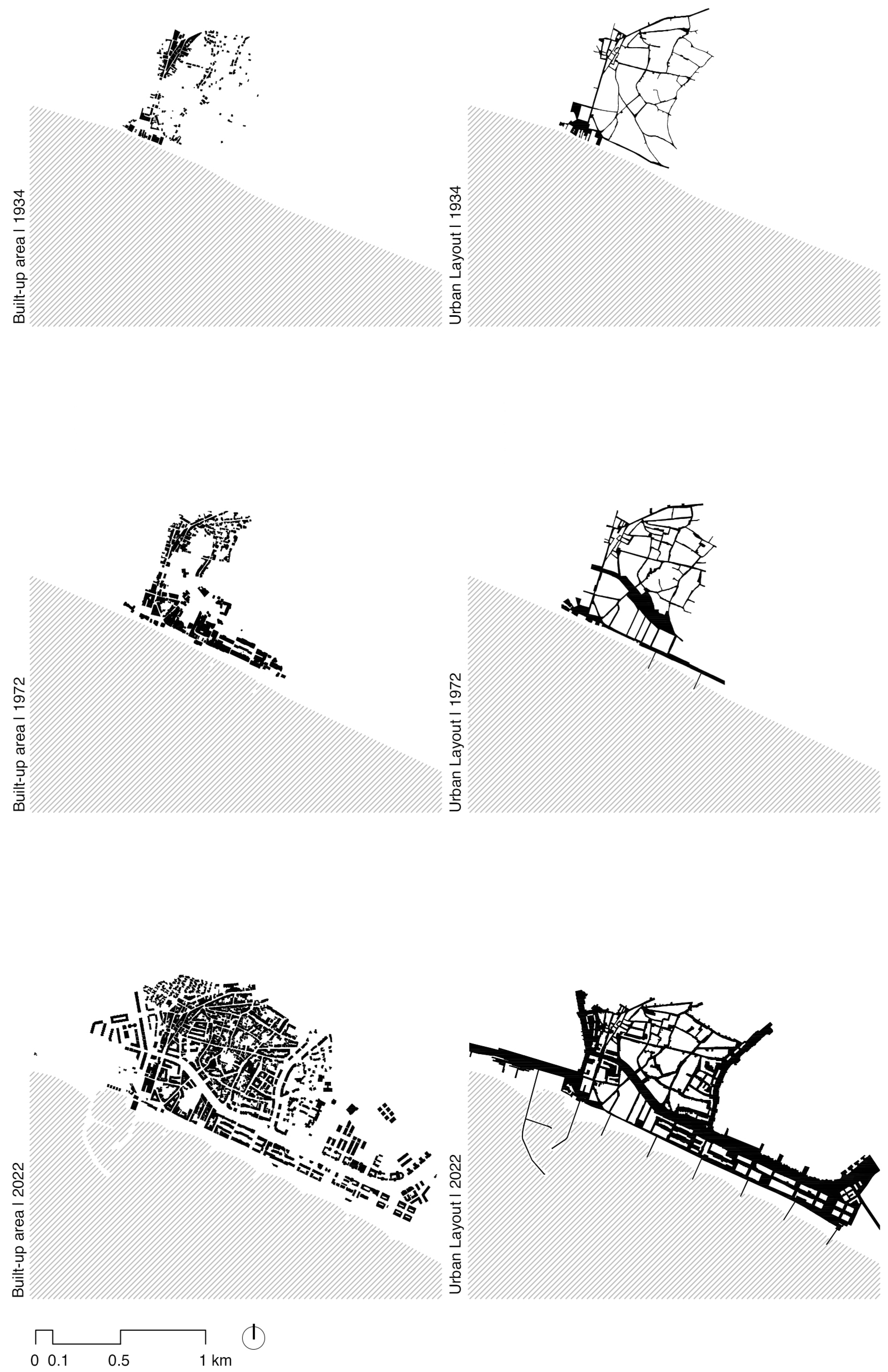
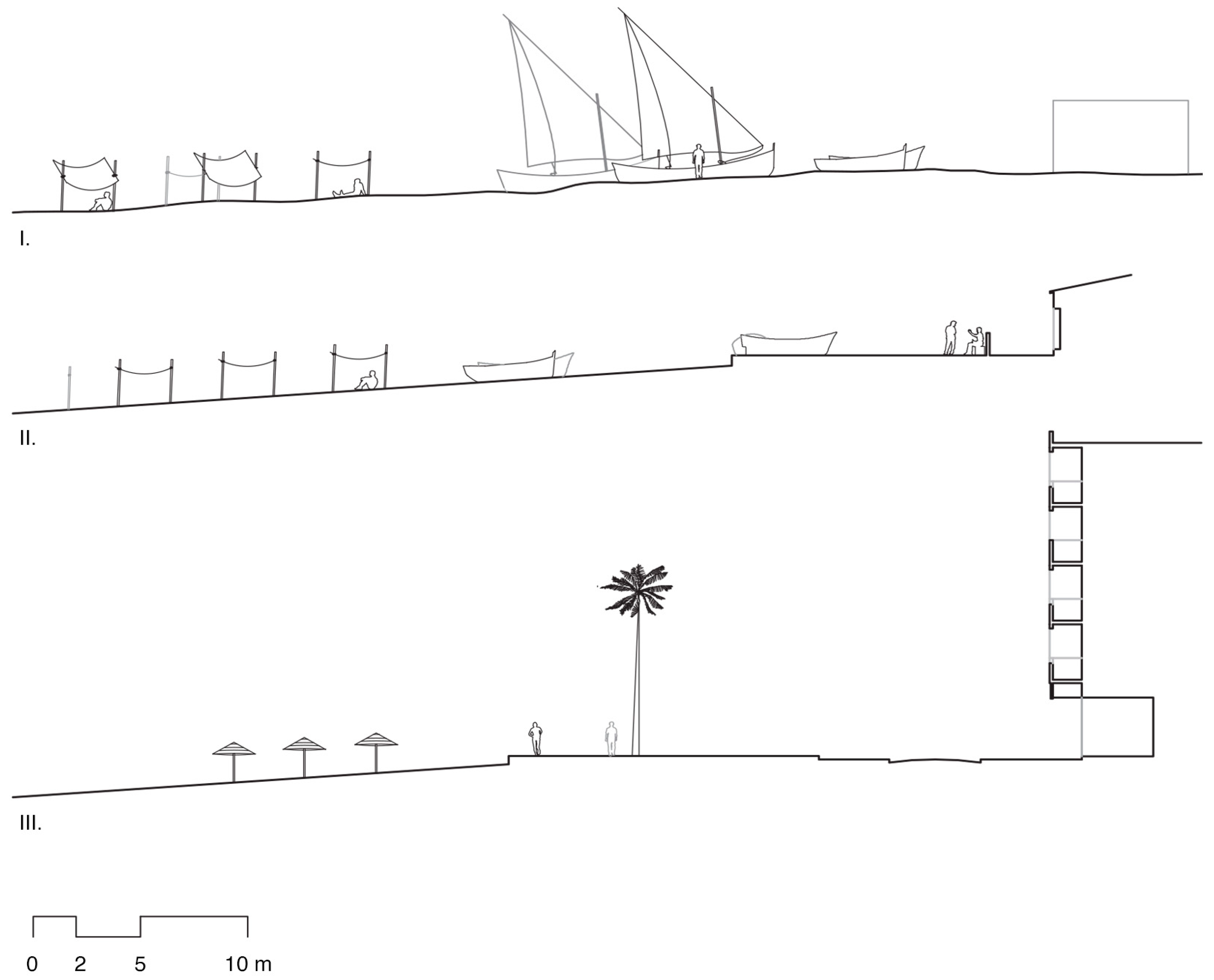
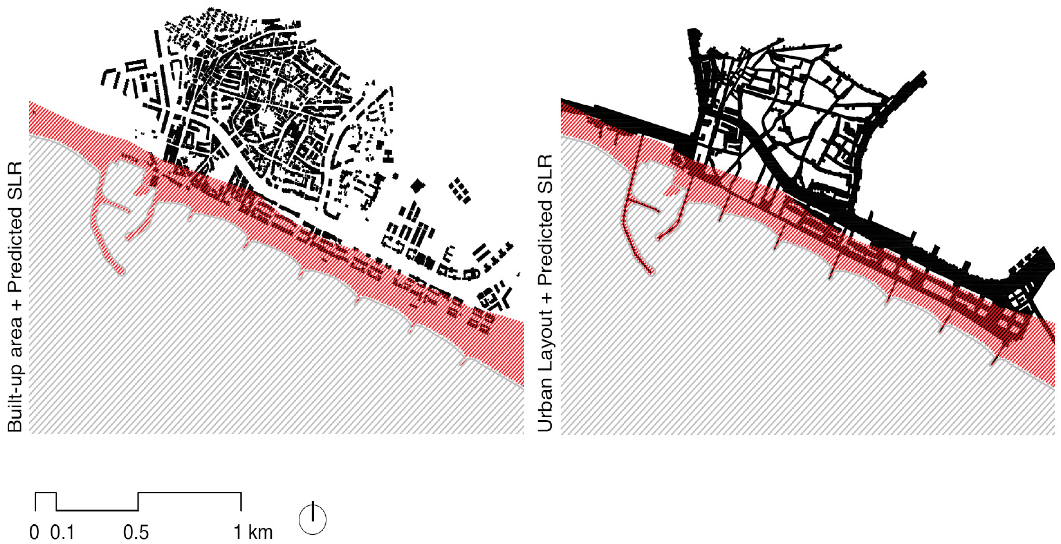
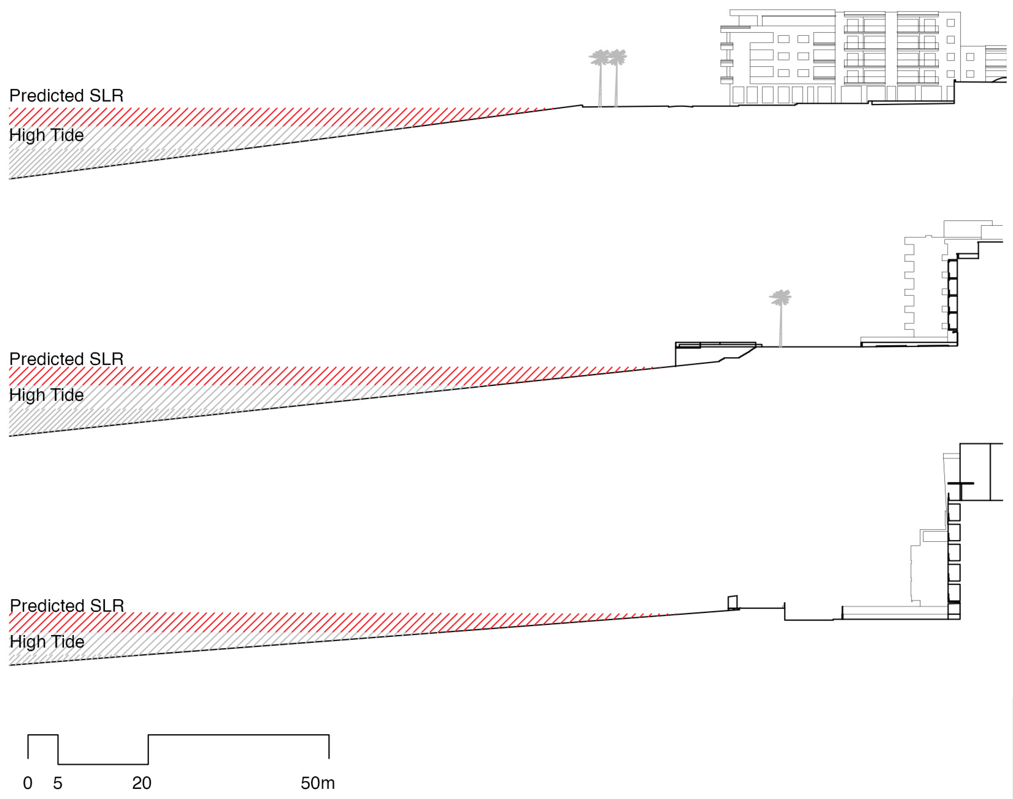
The Case of Quarteira
5. Discussion
6. Conclusions
Author Contributions
Funding
Data Availability Statement
Conflicts of Interest
References
- Bigotte, J.F.; Antunes, A.P.; Krass, D.; Berman, O. The Relationship between Population Dynamics and Urban Hierarchy: Evidence from Portugal. Int. Reg. Sci. Rev. 2014, 37, 149–171. [Google Scholar] [CrossRef]
- Andrade, C.; Freitas, M.C.; Cachado, C.; Cardoso, A.C.; Monteiro, J.H.; Brito, P.; Rebelo, L. Coastal Zones. In Climate Change in Portugal—Scenarios, Impacts and Adaptation Measures—SIAM Project; Santos, F.D., Forbes, K., Moita, R., Eds.; Gradiva: Lisbon, Portugal, 2002; pp. 175–219. [Google Scholar]
- Dal Cin, F.; Fleischmann, M.; Romice, O.; Costa, J.P. Climate Adaptation Plans in the Context of Coastal Settlements: The Case of Portugal. Sustainability 2020, 12, 8559. [Google Scholar] [CrossRef]
- Dorrell, R.; Wentworth, J. Sea Level Rise; Parliamentary Office of Science & Technology: London, UK, 2010; p. 363. Available online: http://www.parliament.uk/documents/post/postpn363-sea-level-rise.pdf (accessed on 15 July 2020).
- INE—Instituto Nacional de Estatística (Statistics Portugal). Available online: https://www.ine.pt/xportal/xmain?xpid=INE&xpgid=ine_publicacoes&PUBLICACOESpub_boui=65586079&PUBLICACOESmodo=2 (accessed on 23 October 2022).
- Plano Intermunicipal de Adaptação às Alterações Climáticas do Algarve, PIAAC-AMAL 2019. Available online: http://hdl.handle.net/10400.1/12870 (accessed on 25 October 2022).
- Estratégia Nacional de Adaptação às Alterações Climáticas 2020, ENAAC 2020. Available online: https://apambiente.pt/clima/estrategia-nacional-de-adaptacao-alteracoes-climaticas (accessed on 25 October 2022).
- Braz Teixeira, S. Evolução do Litoral de Quarteira. In Projecto de Valorização Turistica do Patrimonio Arqueologico Submerso de Quarteira; Actas do Seminário de Valorização turística do património arqueológico submerso do litoral de Quarteira: Vilamoura, Portugal, 2004. [Google Scholar]
- Antunes, C. Assessment of Sea Level Rise at West Coast of Portugal Mainland and Its Projection for the 21st Century. J. Mar. Sci. Eng. Int. 2019, 7, 61. [Google Scholar] [CrossRef] [Green Version]
- Xu, Y.; Ren, C.; Ma, P.; Ho, J.; Wang, W.; Ka-Lun Lau, K.; Lin, H.; Ng, E. Urban morphology detection and computation for urban climate research. Landsc. Urban Plan. 2017, 167, 212–224. [Google Scholar] [CrossRef]
- Batty, M. Darwin at 200 and the evolution of planning. Environ. Plan. B Plan. Des. 2009, 36, 954–955. [Google Scholar] [CrossRef]
- Neumann, B.; Vafeidis, A.T.; Zimmermann, J.; Nicholls, R.J. Future coastal population growth and exposure to sea-level rise and coastal flooding—A global assessment. PLoS ONE 2015, 10, e0118571. [Google Scholar] [CrossRef] [Green Version]
- Fabbri, P. (Ed.) Recreational Uses of Coastal Areas: A Research Project of the Commission on the Coastal Environment, International Geographical Union; The GeoJournal Library; Springer: Dordrecht, The Netherlands, 1990; Volume 12, p. 287. [Google Scholar]
- Small, C.; Nicholls, R.J. A global analysis of human settlement in coastal zones. J. Coast. Res. 2003, 19, 584–599. [Google Scholar]
- Han, H.; Kim, D.; Kim, H.S. Inundation Analysis of Coastal Urban Area under Climate Change Scenarios. Water 2022, 14, 1159. [Google Scholar] [CrossRef]
- Carter, R.W.G. Coastal Environments; Academic Press: Cambridge, MA, USA, 1988. [Google Scholar]
- Church, J.A.; Gregory, J.M. IPCC 2001: 11 Changes in sea level. In International Plant Protection Convention; Cambridge University Press: Cambridge, UK, 2001; pp. 639–694. [Google Scholar]
- Johnston, A.; Slovinsky, P.; Yates, K.L. Assessing the vulnerability of coastal infrastructure to sea level rise using multi-criteria analysis in Scarborough, Maine (USA). Ocean. Coast. Manag. 2014, 95, 176–188. [Google Scholar] [CrossRef] [Green Version]
- Hill, K. Coastal infrastructure: A typology of the next century of adaptation to sea-level rise. Front. Ecol. Environ. 2015, 13, 468–476. [Google Scholar] [CrossRef] [Green Version]
- Sampath, D.; Costa, S.; Carrasco, A.R.; Mendes, I.; Moura, D.; Veiga-Pires, C. Coastline Retreat Projections along South Algarve Due to Sea Level Rise during the 21st Century. In Proceedings of the Congresso Sobre Planeamento e Gestão das Zonas Costeiras dos Países de Expressão Portuguesas, Lisbon, Portugal, 14–16 May 2019. [Google Scholar]
- Barnett, J.; Graham, S.; Mortreux, C.; Fincher, R.; Waters, E.; Hurlimann, A. A local coastal adaptation pathway. Nat. Clim. Change 2014, 4, 1103–1108. [Google Scholar] [CrossRef]
- Nicholls, R.J.; Cazenave, A. Sea-level rise and its impact on coastal zones. Science 2010, 328, 1517–1520. [Google Scholar] [CrossRef] [PubMed]
- Hanson, S.; Nicholls, R.; Ranger, N.; Hallegatte, S.; Corfee-Morlot, J.; Herweijer, C.; Chateau, J. A global ranking of port cities with high exposure to climate extremes. Clim. Chang. 2011, 104, 89–111. [Google Scholar] [CrossRef] [Green Version]
- Vousdoukas, M.I.; Mentaschi, L.; Hinkel, J.; Ward, P.J.; Mongelli, I.; Ciscar, J.-C.; Feyen, L. Economic motivation for raising coastal flood defences in Europe. Nat. Commun. 2020, 11, 2119. [Google Scholar] [CrossRef]
- Chapapría, V.E.; Peris, J.S. Vulnerability of Coastal Areas Due to Infrastructure: The Case of Valencia Port (Spain). Land 2021, 10, 1344. [Google Scholar] [CrossRef]
- Ferreira, Ó.; Dias, J.A.; Taborda, R. Implications of Sea-Level Rise for Continental Portugal. J. Coast. Res. 2008, 242, 317–324. [Google Scholar] [CrossRef]
- Ponte Lira, C.; Nobre Silva, A.; Taborda, R.; Freire de Andrade, C. Coastline evolution of Portuguese low-lying sandy coast in the last 50 years: An integrated approach. Earth Syst. Sci. Data 2016, 8, 265–278. [Google Scholar] [CrossRef] [Green Version]
- Santos, F.D.; Stigter, T.Y.; Faysse, N.; Lourenço, T.C. Impacts and adaptation to climate change in the Mediterranean coastal areas: The CIRCLE-MED initiative. Reg. Environ. Change 2014, 14 (Suppl. S1), 1–3. [Google Scholar] [CrossRef] [Green Version]
- Antunes, C.; Rocha, C.; Catita, C. Coastal flood assessment due to sea level rise and extreme storm events: A case study of the atlantic coast of Portugal’s mainland. Geosciences 2019, 9, 239. [Google Scholar] [CrossRef] [Green Version]
- Freitas, J.G.; Dias, J.A. Figueira da Foz (Portugal): O compromisso (possível) entre o Homem e o Meio. In Formação e Ocupação de Litorais nas Margens do Atlântico—Brasil/Portugal, Rio de Janeiro; Pereira, S., Freitas, J., Bergamaschi, S., Rodrigues, M.A., Eds.; Corbã Editora e Artes Gráficas: Rio de Janeiro, Brazil, 2014; pp. 17–32. Available online: http://hdl.handle.net/10362/19459 (accessed on 21 September 2022).
- Pranzini, E.; Wetzel, L.; Williams, A.T. Conclusions. In Coastal Erosion and Protection in Europe; Pranzini, E., Williams, A.T., Eds.; Routledge/Earthscan: London, UK, 2013; pp. 427–445. [Google Scholar] [CrossRef]
- Rocha, E. Crescimento económico em Portugal nos anos 1960–73: Alteração estrutural e ajustamento da oferta à procura de trabalho. Análise Soc. 1984, 20, 621–644. [Google Scholar]
- Taborda, R. Modelação da Dinâmica Sedimentar na Plataforma Continental Portuguesa. Ph.D. Thesis, Universidade de Lisboa, Lisbon, Portugal, 2000; p. 366. [Google Scholar]
- Proença, S.B. Reading and Interpreting Portuguese Atlantic Seashore Streets in Sea Level Rise Context. In Happiness. The Built Environment: Shaping the Quality of Life, Proceedings of the ARCC-EAAE 2018 International Conference, Philadelphia, PA, USA, 9 November 2018; Wingert-Playdon, K., Rashed-Ali, H., Eds.; ARCC: Philadelphia, PA, USA, 2018; Volume 1, pp. 65–73. [Google Scholar]
- Gandelosonas, M. The City as the Object of Architecture. Assemblage 1998, 37, 128–144. Available online: https://www.jstor.org/stable/3171359 (accessed on 15 October 2022). [CrossRef]
- Proença, S.B. A Diversidade da Rua na Cidade de Lisboa. Ph.D. Thesis, Universidade Técnica de Lisboa, Lisbon, Portugal, 2014. [Google Scholar]
- Almeida, C. Hidrogeologia do sistema aquifero de Quarteira (Algarve). Geolis Rev. Secção Geol. Ec. Apl. 1992, VI, 61–79. [Google Scholar]
- Relvas, D. A Cidade dos Outros: O Caso de Quarteira. Dissertação de Mestrado em Cidades e Culturas Urbanas. Ph.D. Thesis, Faculdade de Economia da Universidade de Coimbra, Coimbra, Portugal, 2010. [Google Scholar]
- Lobo, S. Tracing the Edge: Portuguese Coastal Tourism Planning and Architecture of the 1960s. In Architecture for Leisure in Post-war Europe 1945–1989; Gosseye, J., Heynen, H., Eds.; Routledge, Taylor & Francis Group: Abingdon, UK, 2018; pp. 14–31. [Google Scholar] [CrossRef]
- Marques, F. As Arribas do Litoral do Algarve- Dinâmica, Processos e Mecanismos. Ph.D. Thesis, Universidade de Lisboa, Lisbon, Portugal, 1997; pp. 556p. [Google Scholar]
- Correia, F.; Dias, J.A.; Boski, T. The retreat of eastern Quarteira cliffed coast and its possible causes (preliminary results). Gaia 1994, 9, 119–122. [Google Scholar]
- Correia, F.; Dias, J.A.; Boski, T. Determinação do Recuo Dasarribas Situadas a Oriente de Quarteira por Reconstituição Fotogramétrica: Evolução Entre 1958 e 1991. In Proceedings of the 8° Congresso do Algarve, Vilamoura, Portugal, 4–9 April 1995; pp. 405–411. [Google Scholar]
- Todd, P.A.; Heery, E.C.; Loke, L.H.; Thurstan, R.H.; Kotze, D.J.; Swan, C. Towards an urban marine ecology: Characterizing the drivers, patterns and processes of marine ecosystems in coastal cities. Oikos 2019, 128, 1215–1242. [Google Scholar] [CrossRef] [Green Version]
- Hallegatte, S.; Ranger, N.; Mestre, O.; Dumas, P.; Corfee-Morlot, J.; Herweijer, C.; Wood, R.M. Assessing climate change impacts, sea level rise and storm surge risk in port cities: A case study on Copenhagen. Clim. Chang. 2011, 104, 113–137. [Google Scholar] [CrossRef] [Green Version]
- Griggs, G.; Reguero, B.G. Coastal Adaptation to Climate Change and Sea-Level Rise. Water 2021, 13, 2151. [Google Scholar] [CrossRef]
- Magnan, A.K.; Oppenheimer, M.; Garschagen, M.; Buchanan, M.K.; Duvat, V.K.E.; Forbes, D.L.; Ford, J.D.; Lambert, E.; Petzold, J.; Renaud, F.G.; et al. Sea level rise risks and societal adaptation benefits in low-lying coastal areas. Sci. Rep. 2022, 12, 10677. [Google Scholar] [CrossRef]
- Hurlimann, A.; Barnett, J.; Fincher, R.; Osbaldiston, N.; Mortreux, C.; Graham, S. Urban planning and sustainable adaptation to sea-level rise. Landsc. Urban Plan. 2014, 126, 84–93. [Google Scholar] [CrossRef]
- Lee, Y. Coastal Planning Strategies for Adaptation to Sea Level Rise: A Case Study of Mokpo, Korea. J. Build. Constr. Plan. Res. 2014, 2, 74–81. [Google Scholar] [CrossRef] [Green Version]
- Petrişor, A.-I.; Hamma, W.; Nguyen, H.D.; Randazzo, G.; Muzirafuti, A.; Stan, M.-I.; Tran, V.T.; Aştefănoaiei, R.; Bui, Q.-T.; Vintilă, D.-F.; et al. Degradation of Coastlines under the Pressure of Urbanization and Tourism: Evidence on the Change of Land Systems from Europe, Asia and Africa. Land 2020, 9, 275. [Google Scholar] [CrossRef]
- Giovinazzi, O.; Moretti, M. Port Cities and Urban Waterfront: Transformations and Opportunities. TeMa. J. Land Use Mobil. Environ. 2010, 3, 57–64. [Google Scholar] [CrossRef]


Disclaimer/Publisher’s Note: The statements, opinions and data contained in all publications are solely those of the individual author(s) and contributor(s) and not of MDPI and/or the editor(s). MDPI and/or the editor(s) disclaim responsibility for any injury to people or property resulting from any ideas, methods, instructions or products referred to in the content. |
© 2023 by the authors. Licensee MDPI, Basel, Switzerland. This article is an open access article distributed under the terms and conditions of the Creative Commons Attribution (CC BY) license (https://creativecommons.org/licenses/by/4.0/).
Share and Cite
Barreiros Proença, S.; Dal Cin, F.; Valente Monteiro, C.; Franco, M.I.; Matos Silva, M.; Saeed Al Mushayt, N. The Urban Public Space between Land and Sea: The Case of Quarteira, Portugal. Land 2023, 12, 539. https://doi.org/10.3390/land12030539
Barreiros Proença S, Dal Cin F, Valente Monteiro C, Franco MI, Matos Silva M, Saeed Al Mushayt N. The Urban Public Space between Land and Sea: The Case of Quarteira, Portugal. Land. 2023; 12(3):539. https://doi.org/10.3390/land12030539
Chicago/Turabian StyleBarreiros Proença, Sérgio, Francesca Dal Cin, Cristiana Valente Monteiro, Maria Inês Franco, Maria Matos Silva, and Nawaf Saeed Al Mushayt. 2023. "The Urban Public Space between Land and Sea: The Case of Quarteira, Portugal" Land 12, no. 3: 539. https://doi.org/10.3390/land12030539