


Digital Twin for Active Stakeholder Participation in Land-Use Planning


Abstract
:1. Introduction
- Could new technologies, and in particular digital twins, fundamentally alter the degree of stakeholder participation in and stakeholder influence on one or more stages in a land-use-planning process and, if so, how, where, and under which conditions?
- Which qualities and potentials of the DT technology, compared with those of conventional geospatial technologies, could enhance the decision space of stakeholders in land-use planning?
2. Theoretical Backgrounds
2.1. “Responsible” Land-Use Planning
2.2. Social Construction of Technology
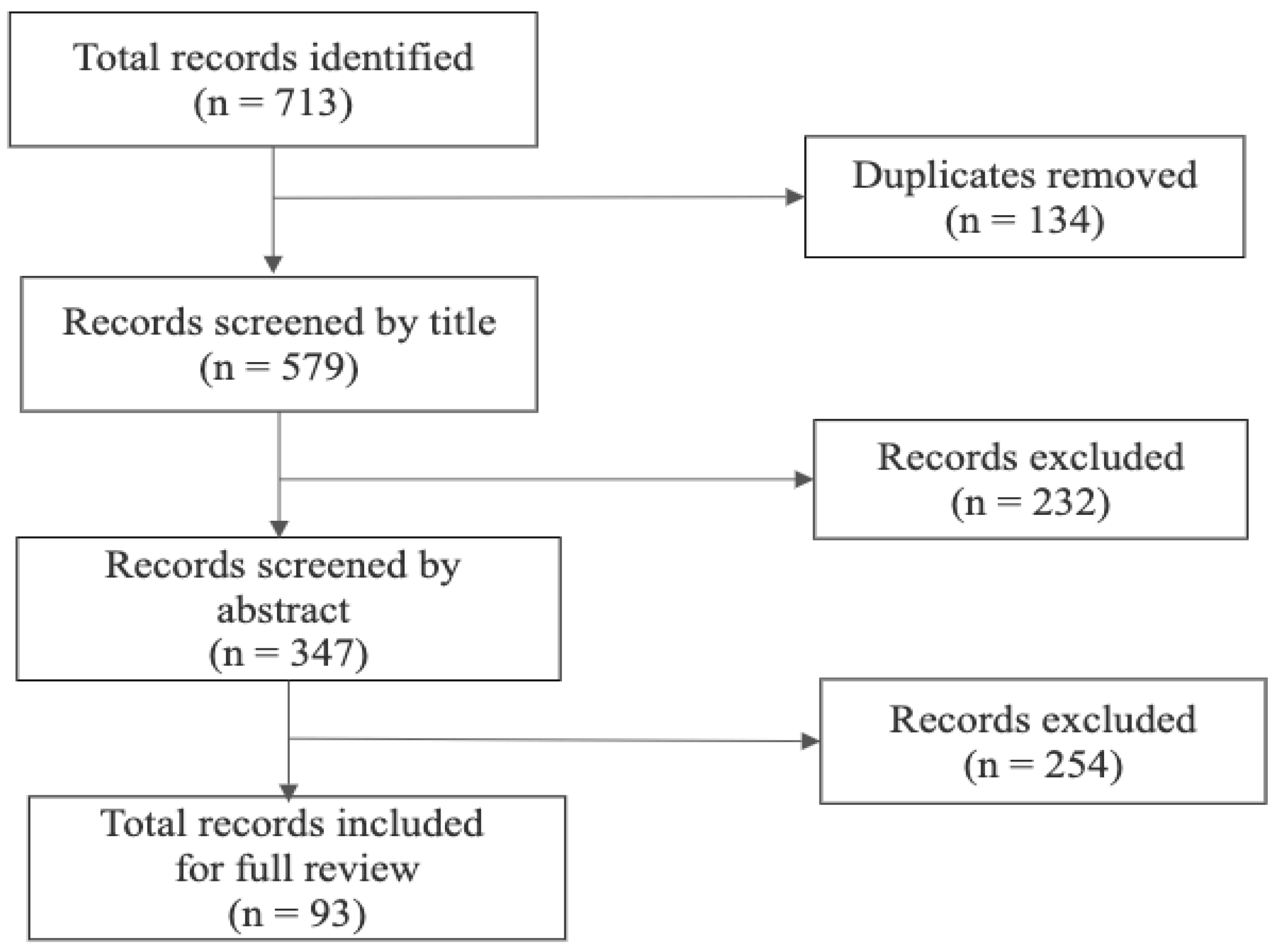
3. Materials and Methods
4. Results
4.1. Digital Twin: Concepts, Characteristics, and Potentials
4.2. Land-Use Planning Phases and Stakeholder Participation
4.3. Geospatial Data Twinning and Land-Use Planning
4.4. Current Challenges and Limitations of Digital Twins
5. Discussion
6. Conclusions
Author Contributions
Funding
Data Availability Statement
Acknowledgments
Conflicts of Interest
References
- Asante, L.A. Urban Governance in Ghana: The Participation of Traders in the Redevelopment of Kotokuraba Market in Cape Coast. Afr. Geogr. Rev. 2020, 39, 361–378. [Google Scholar] [CrossRef] [Green Version]
- Koontz, T.M. We Finished the Plan, So Now What? Impacts of Collaborative Stakeholder Participation on Land Use Policy. Policy Stud. J. 2005, 33, 459–481. [Google Scholar] [CrossRef]
- Pantić, M.; Cilliers, J.; Cimadomo, G.; Montaño, F.; Olufemi, O.; Mallma, S.T.; van den Berg, J. Challenges and Opportunities for Public Participation in Urban and Regional Planning during the COVID-19 Pandemic—Lessons Learned for the Future. Land 2021, 10, 1379. [Google Scholar] [CrossRef]
- Bourgoin, J.; Castella, J.-C.; Pullar, D.; Lestrelin, G.; Bouahom, B. Toward a Land Zoning Negotiation Support Platform: “Tips and Tricks” for Participatory Land Use Planning in Laos. Landsc. Urban Plan. 2012, 104, 270–278. [Google Scholar] [CrossRef]
- Baker, M.; Hincks, S.; Sherriff, G. Getting Involved in Plan Making: Participation and Stakeholder Involvement in Local and Regional Spatial Strategies in England. Environ. Plan. C Gov. Policy 2010, 28, 574–594. [Google Scholar] [CrossRef] [Green Version]
- GIZ. Land Use Planning. Concepts, Tools and Applications; GIZ: Eschborn, Germany, 2012; pp. 1–268. [Google Scholar]
- Yeboah, E.; Obeng-Odoom, F. ‘We Are Not the Only Ones to Blame’: District Assemblies’ Perspectives on the State of Planning in Ghana. Commonw. J. Local Gov. 2010, 78–98. [Google Scholar] [CrossRef] [Green Version]
- Patel, M.; Kok, K.; Rothman, D.S. Participatory Scenario Construction in Land Use Analysis: An Insight into the Experiences Created by Stakeholder Involvement in the Northern Mediterranean. Land Use Policy 2007, 24, 546–561. [Google Scholar] [CrossRef]
- de Vries, W.T.; Chigbu, U.E. Responsible Land Management—Concept and Application Ina Rural Territorial Context. Flächenmanagement Bodenordn. 2017, 79, 65–73. [Google Scholar]
- Kopáček, M. Land-Use Planning and the Public: Is There an Optimal Degree of Civic Participation? Land 2021, 10, 90. [Google Scholar] [CrossRef]
- de Vries, W.T. Potential of Big Data for Pro-Active Participatory Land Use Planning. Geoplanning J. Geomat. Plan. 2018, 5, 205–214. [Google Scholar] [CrossRef]
- Namatama, N. An Assessment of Stakeholders’ Participation in Land Use Planning Process of Luapula Province Planning Authority. Land Use Policy 2020, 97, 104735. [Google Scholar] [CrossRef]
- Adade, D. Urbanisation and Urban Governance in Ghana: Identifying Key Actors and Their Roles. Afr. J. InterMultidisciplinary Stud. 2020, 2, 88–102. [Google Scholar] [CrossRef]
- Pettit, C.J.; Cartwright, W.; Berry, M. Geographical Visualization: A Participatory Planning Support Tool for Imagining Landscape Futures. Appl. GIS 2006, 2, 22.1–22.17. [Google Scholar] [CrossRef]
- Kitchin, R.; Young, G.W.; Dawkins, O. Planning and 3D Spatial Media: Progress, Prospects, and the Knowledge and Experiences of Local Government Planners in Ireland. Plan. Theory Pract. 2021, 22, 349–367. [Google Scholar] [CrossRef]
- Botín-Sanabria, D.M.; Mihaita, A.-S.; Peimbert-García, R.E.; Ramírez-Moreno, M.A.; Ramírez-Mendoza, R.A.; de J. Lozoya-Santos, J. Digital Twin Technology Challenges and Applications: A Comprehensive Review. Remote Sens. 2022, 14, 1335. [Google Scholar] [CrossRef]
- Grieves, M. Virtually Intelligent Product Systems: Digital and Physical Twins. In Complex Systems Engineering: Theory and Practice; American Institute of Aeronautics and Astronautics: Reston, VA, USA, 2019; pp. 175–200. [Google Scholar] [CrossRef]
- Fuller, A.; Fan, Z.; Day, C.; Barlow, C. Digital Twin: Enabling Technologies, Challenges and Open Research. IEEE Access 2020, 8, 108952–108971. [Google Scholar] [CrossRef]
- Abdeen, N.; Sepasgozar, S. City Digital Twin Concepts: A Vision for Community Participation. Env. Sci Proc 2021, 12, 19. [Google Scholar] [CrossRef]
- Shahat, E.; Hyun, C.T.; Yeom, C. City Digital Twin Potentials: A Review and Research Agenda. Sustainability 2021, 13, 3386. [Google Scholar] [CrossRef]
- Dembski, F.; Wössner, U.; Letzgus, M. The Digital Twin Tackling Urban Challenges with Models, Spatial Analysis and Numerical Simulations in Immersive Virtual Environments. In Proceedings of the Blucher Design Proceedings, Porto, Portugal, 11–13 September 2019; Editora Blucher: Porto, Portugal, 2019; pp. 795–804. [Google Scholar]
- Virtual Singapore Virtual Singapore—3D Modelling and Visualisation. Available online: https://www.nrf.gov.sg/programmes/virtual-singapore (accessed on 31 August 2022).
- Smart City Lab Basel Digital Twins for Urban Planning. Available online: https://smartcitylabbasel.ch/en/projekte/digital-twins-for-urban-planning/ (accessed on 31 August 2022).
- Metternicht, G. Land Use and Spatial Planning: Enabling Sustainable Management of Land Resources; SpringerBriefs in Earth Sciences; Springer International Publishing: Cham, Switzerland, 2018; ISBN 978-3-319-71860-6. [Google Scholar]
- Lagopoulos, A.P. Clarifying Theoretical and Applied Land-Use Planning Concepts. Urban Sci. 2018, 2, 17. [Google Scholar] [CrossRef] [Green Version]
- Campbell, S. Green Cities, Growing Cities, Just Cities? Urban Planning and the Contradictions of Sustainable Development. J. Am. Plann. Assoc. 1996, 62, 296–312. [Google Scholar] [CrossRef]
- Mitchell, D.; Enemark, S.; van der Molen, P. Climate Resilient Urban Development: Why Responsible Land Governance Is Important. Land Use Policy 2015, 48, 190–198. [Google Scholar] [CrossRef]
- Asiama, K.O.; Bennett, R.; Zevenbergen, J.; Asiama, S.O. Land Valuation in Support of Responsible Land Consolidation on Ghana’s Rural Customary Lands. Surv. Rev. 2018, 50, 288–300. [Google Scholar] [CrossRef] [Green Version]
- Zevenbergen, J.; de Vries, W.; Bennett, R.M. Advances in Responsible Land Administration; CRC Press: Boca Raton, FL, USA, 2015; ISBN 978-1-4987-1961-2. [Google Scholar]
- FAO. Voluntary Guidelines on the Responsible Governance of Tenure of Land, Fisheries and Forests in the Context of National Food Security; FAO: Rome, Italy, 2012; ISBN 978-92-5-107277-6. [Google Scholar]
- de Vries, W.T. Testing and Improving the 8R Framework of Responsible Land Management to Assess Major Land Interventions. In Proceedings of the Smart Surveyors for Land and Water Management—Challenges in a New Reality, Apeldoorn, The Netherlands, 21–25 June 2021. [Google Scholar]
- Johnson, M.L. Using GIS for Stormwater Management and Responsible Land Use Planning; American Society of Civil Engineers: Williamsburg, VA, USA, 2005. [Google Scholar]
- Bijker, W.E. Of Bicycles, Bakelites, and Bulbs: Toward a Theory of Sociotechnical Change; MIT Press: Cambridge, MA, USA, 1995; ISBN 978-0-262-52227-4. [Google Scholar]
- Pinch, T.J.; Bijker, W.E. The Social Construction of Facts and Artefacts: Or How the Sociology of Science and the Sociology of Technology Might Benefit Each Other. Soc. Stud. Sci. 1984, 14, 399–441. [Google Scholar] [CrossRef]
- Moody, R. Mapping Power: Geographical Information Systems, Agenda-Setting and Policy Design; Erasmus Universiteit: Rotterdam, The Netherlands, 2010. [Google Scholar]
- Bijker, W.E.; Hughes, T.P.; Pinch, T. The Social Construction of Technological Systems: New Directions in the Sociology and History of Technology; MIT Press: Cambridge, MA, USA, 2012; ISBN 978-0-262-02262-0. [Google Scholar]
- Yousefikhah, S. Sociology of Innovation: Social Construction of Technology Perspective. AD-Minister 2017, 30, 31–43. [Google Scholar] [CrossRef] [Green Version]
- Elle, M.; Dammann, S.; Lentsch, J.; Hansen, K. Learning from the Social Construction of Environmental Indicators: From the Retrospective to the pro-Active Use of SCOT in Technology Development. Build. Environ. 2010, 45, 135–142. [Google Scholar] [CrossRef]
- Russell, C.L. An Overview of the Integrative Research Review. Prog. Transplant. 2005, 15, 8–13. [Google Scholar] [CrossRef]
- Torraco, R.J. Writing Integrative Literature Reviews: Using the Past and Present to Explore the Future. Hum. Resour. Dev. Rev. 2016, 15, 404–428. [Google Scholar] [CrossRef]
- Torraco, R.J. Writing Integrative Literature Reviews: Guidelines and Examples. Hum. Resour. Dev. Rev. 2005, 4, 356–367. [Google Scholar] [CrossRef]
- Toronto, C.; Remington, R. Step-by-Step Guide to Conducting an Integrative Review; Springer: Cham, Switzerland, 2020; ISBN 978-3-030-37504-1. [Google Scholar]
- Whittemore, R.; Knafl, K. The Integrative Review: Updated Methodology. J. Adv. Nurs. 2005, 52, 546–553. [Google Scholar] [CrossRef]
- Cooper, H.M. Synthesizing Research: A Guide for Literature Reviews, 3rd ed.; Applied social research methods series; Sage Publications: Thousand Oaks, CA, USA, 1998; ISBN 978-0-7619-1347-4. [Google Scholar]
- Dwyer, P.A. Analysis and Synthesis. In A Step-by-Step Guide to Conducting an Integrative Review; Toronto, C.E., Remington, R., Eds.; Springer International Publishing: Cham, Switzerland, 2020; pp. 57–70. ISBN 978-3-030-37504-1. [Google Scholar]
- Vrabič, R.; Erkoyuncu, J.A.; Butala, P.; Roy, R. Digital Twins: Understanding the Added Value of Integrated Models for through-Life Engineering Services. Procedia Manuf. 2018, 16, 139–146. [Google Scholar] [CrossRef]
- Bacchiega, G.; Bondani, G. Creating an Embedded Digital Twin: Monitor, Understand and Predict Device Health Failure. In Proceedings of the Mechatronics and Industry 4.0 Conference, Rovereto, Italy, 15–16 February 2018. [Google Scholar]
- Sharma, A.; Kosasih, E.; Zhang, J.; Brintrup, A.; Calinescu, A. Digital Twins: State of the Art Theory and Practice, Challenges, and Open Research Questions. J. Ind. Inf. Integr. 2022, 30, 100383. [Google Scholar] [CrossRef]
- Howard, D. The Digital Twin: Virtual Validation in Electronics Development And Design. In Proceedings of the 2019 Pan Pacific Microelectronics Symposium (Pan Pacific), Kauai, HI, USA, 11–14 February 2019; pp. 1–9. [Google Scholar]
- Shao, G.; Helu, M. Framework for a Digital Twin in Manufacturing: Scope and Requirements. Manuf. Lett. 2020, 24, 105–107. [Google Scholar] [CrossRef]
- Kritzinger, W.; Karner, M.; Traar, G.; Henjes, J.; Sihn, W. Digital Twin in Manufacturing: A Categorical Literature Review and Classification. IFAC-PapersOnline 2018, 51, 1016–1022. [Google Scholar] [CrossRef]
- Luan, T.H.; Liu, R.; Gao, L.; Li, R.; Zhou, H. The Paradigm of Digital Twin Communications. arXiv 2021, arXiv:2105.07182 2021. [Google Scholar]
- Resonai How to Create a Digital Twin. Available online: https://www.resonai.com/blog/how-to-create-a-digital-twin (accessed on 5 August 2022).
- Grieves, M.; Vickers, J. Digital Twin: Mitigating Unpredictable, Undesirable Emergent Behavior in Complex Systems. In Transdisciplinary Perspectives on Complex Systems: New Findings and Approaches; Kahlen, F.-J., Flumerfelt, S., Alves, A., Eds.; Springer International Publishing: Cham, Switzerland, 2017; pp. 85–113. ISBN 978-3-319-38756-7. [Google Scholar]
- Wright, L.; Davidson, S. How to Tell the Difference between a Model and a Digital Twin. Adv. Model. Simul. Eng. Sci. 2020, 7, 13. [Google Scholar] [CrossRef]
- Kvam, R. Meaningful Stakeholder Consultation; Environmental and Social Risk and Opportunity; Inter-American Development Bank: Washington, DC, USA, 2017. [Google Scholar]
- Wang, J.; Aenis, T. Stakeholder Analysis in Support of Sustainable Land Management: Experiences from Southwest China. J. Environ. Manag. 2019, 243, 1–11. [Google Scholar] [CrossRef]
- Eisenfuhr, F. Decision Making; Springer: New York, NY, USA, 2011. [Google Scholar]
- Lunenburg, F.C. The Decision Making Process. Natl. Forum Educ. Adm. Superv. 2010, 27, 1–13. [Google Scholar]
- FAO. Guidelines for Land-Use Planning; FAO Development Series; FAO: Rome, Italy, 1993. [Google Scholar]
- Beurden, J.A.M.B.; van Lammeren, R.J.A.; Hoogerwerf, T.; Bouwman, A.A. Linking Land Use Modelling and 3D Visualisation. In Proceedings of the Innovations in Design & Decision Support Systems in Architecture and Urban Planning, Zhengzhou, China, 25–30 October 2019; Van Leeuwen, J.P., Timmermans, H.J.P., Eds.; Springer Netherlands: Dordrecht, The Netherlands, 2006; pp. 85–101. [Google Scholar]
- Judge, S.; Harrie, L. Visualizing a Possible Future: Map Guidelines for a 3D Detailed Development Plan. J. Geovisualization Spat. Anal. 2020, 4, 7. [Google Scholar] [CrossRef]
- Billger, M.; Thuvander, L.; Wästberg, B.S. In Search of Visualization Challenges: The Development and Implementation of Visualization Tools for Supporting Dialogue in Urban Planning Processes. Environ. Plan. B Urban Anal. City Sci. 2017, 44, 1012–1035. [Google Scholar] [CrossRef]
- PlanningTank Benefits of 3D Modelling in Urban Planning. Available online: https://planningtank.com/city-insight/benefits-3d-modelling-urban-planning (accessed on 11 February 2022).
- Biljecki, F.; Ledoux, H.; Stoter, J. An Improved LOD Specification for 3D Building Models. Comput. Environ. Urban Syst. 2016, 59, 25–37. [Google Scholar] [CrossRef] [Green Version]
- Biljecki, F.; Ledoux, H.; Stoter, J. Redefining the Level of Detail for 3D Models. GIM Int. 2014, 28, 21–23. [Google Scholar]
- Sabri, S.; Pettit, C.; Kalantari, M.; Rajabifard, A.; White, M.; Lade, O.; Ngo, T. What Are Essential Requirements in Planning for Future Cities Using Open Data Infrastructures and 3D Data Models? In Proceedings of the 14th International Conference on Computers in Urban Planning and Urban Management, Cambridge, MA, USA, 8 June 2015. [Google Scholar]
- Abdullah, Q. Top Geospatial Trends to Watch in 2021; American Society for Photogrammetry and Remote Sensing: Baton Rouge, LA, USA, 2021. [Google Scholar]
- München Digital Digitalstrategie. Available online: https://muenchen.digital/digitalisierungsstrategie/ (accessed on 31 August 2022).
- Steinbeis A Habitat for Digital Twins. Available online: https://transfermagazin.steinbeis.de/?p=11748&lang=en (accessed on 31 August 2022).
- Cityzenith Cityzenith’s Digital Twin for Las Vegas Enters Second Phase. Available online: https://cityzenith.com/post/the-city-of-las-vegas-unveils-advanced-digital-twin-at-consumer-electronics-showcase-ces (accessed on 31 August 2022).
- London Digital Twin Research Centre London Digital Twin Research Centre—Future of Digital Technologies. Available online: https://dt.mdx.ac.uk/ (accessed on 31 August 2022).
- Stadt Zürich Digital Twin—Stadt Zürich. Available online: https://www.stadt-zuerich.ch/portal/de/index/politik_u_recht/stadtrat/weitere-politikfelder/smartcity/english/projects/zwilling.html (accessed on 31 August 2022).
- Gunton, T.; Day, J.C. The Theory and Practice of Collaborative Planning in Resource and Environmental Management. Environments 2003, 31, 5–20. [Google Scholar]
- Elsheikh, A.; Alzamili, H.H.; Al-Zayadi, S.K.; Alboo-Hassan, A.S. Integration of GIS and BIM in Urban Planning—A Review. In Proceedings of the IOP Conference Series: Materials Science and Engineering, Samawah, Iraq, 23–24 December 2020; IOP Publishing: Bristol, UK, 2021; Volume 1090, p. 012128. [Google Scholar]
- Yaakup, A.; Sulaiman, S.; Musa, N.; Ahmad, M.J.; Ibrahim, M.Z. GIS as Tools for Monitoring the Urban Development in Metropolitan Region: A Case of Klang Valley Region, Peninsular Malaysia. In GISDECO; ITC: Enschede, The Netherlands, 2002; pp. 1–13. [Google Scholar]
- de Vries, W.T. Trends in The Adoption of New Geospatial Technologies for Spatial Planning and Land Management in 2021. Geoplanning J. Geomat. Plan. 2021, 8, 85–98. [Google Scholar] [CrossRef]
- Greene, R.W. GIS in Public Policy: Using Geographic Information for More Effective Government; ESRI Press: Redlands, CA, USA, 2000; ISBN 978-1-879102-66-8. [Google Scholar]
- Hovik, S.; Giannoumis, G.A. Linkages Between Citizen Participation, Digital Technology, and Urban Development. In Citizen Participation in the Information Society; Hovik, S., Giannoumis, G.A., Reichborn-Kjennerud, K., Ruano, J.M., McShane, I., Legard, S., Eds.; Springer International Publishing: Cham, Switzerland, 2022; pp. 1–23. ISBN 978-3-030-99939-1. [Google Scholar]
- Jnr, B.A.; Petersen, S.A. Using an Extended Technology Acceptance Model to Predict Enterprise Architecture Adoption in Making Cities Smarter. Environ. Syst. Decis. 2022. [Google Scholar] [CrossRef]
- Davis, F.D.; Bagozzi, R.P.; Warshaw, P.R. User Acceptance of Computer Technology: A Comparison of Two Theoretical Models. Manag. Sci. 1989, 35, 982–1003. [Google Scholar] [CrossRef] [Green Version]
- Spatial Corp Digital Twins and BIM: Innovation, Intersection, and Interaction. Available online: https://blog.spatial.com/digital-twin-bim (accessed on 8 November 2022).
- Batty, M. Digital Twins. Environ. Plan. B Urban Anal. City Sci. 2018, 45, 817–820. [Google Scholar] [CrossRef] [Green Version]
- Tomko, M.; Winter, S. Beyond Digital Twins—A Commentary. Environ. Plan. B Urban Anal. City Sci. 2019, 46, 395–399. [Google Scholar] [CrossRef]


| Integration | Fidelity | |
|---|---|---|
| Categorisation | Real time | Complete |
| Near real time | Partial | |
| Online | ||
| Offline (partial) | ||
| Offline (virtual duplicate) |
| Characteristics of Digital Twins | Description | Sources |
|---|---|---|
| Modelling and visualisation | Digital twins can capture, create, and model physical entities in 3D. | [18] |
| Real-time monitoring | DT can show the current status of the physical asset in real time or at a given time. | [49] |
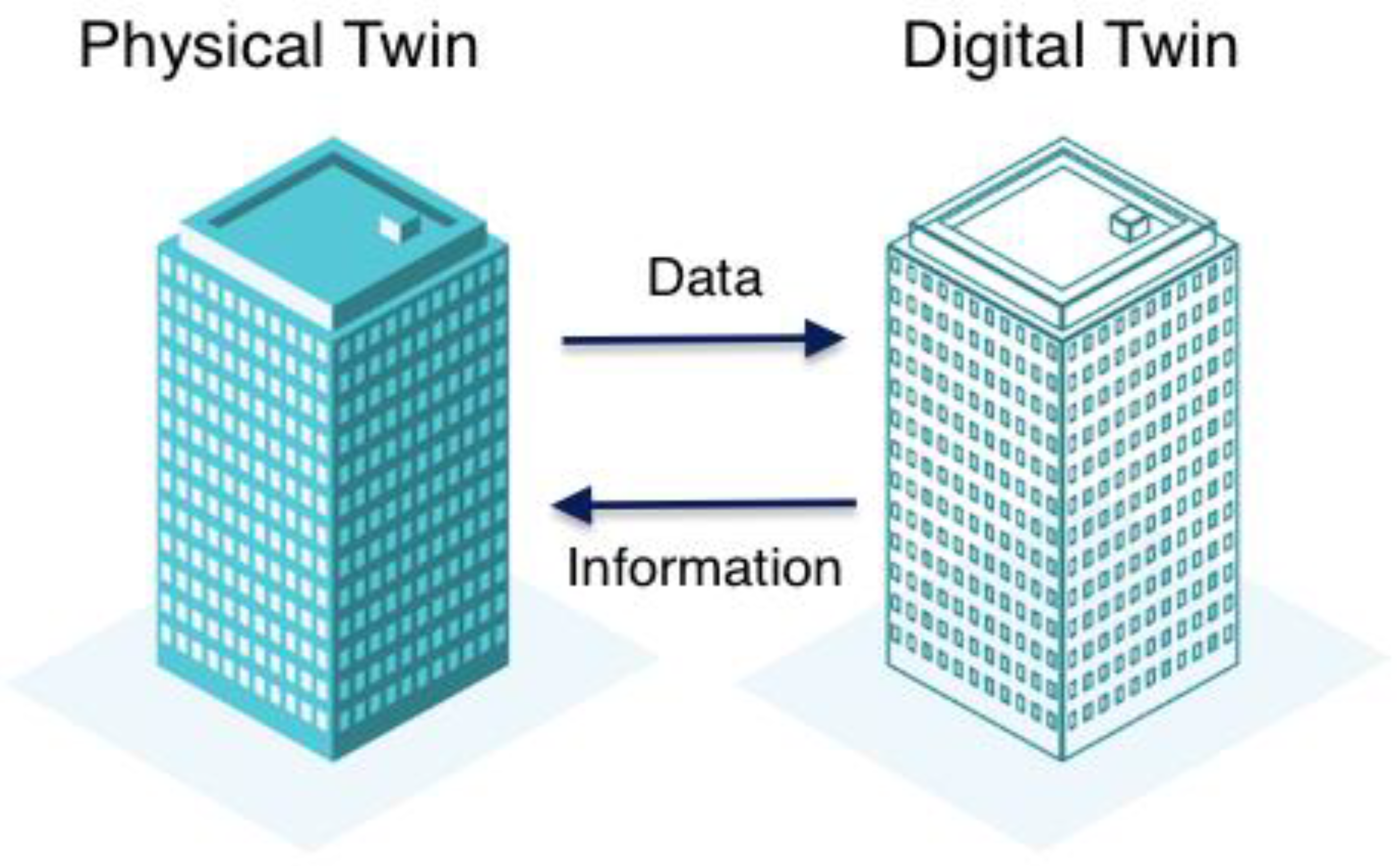
| Connectivity and communication | There is a 2-way synchronising relationship between the digital model and the physical asset. It also ensures an accurate and timely flow of information through all IoT devices. | [17,48,54] |
| Integration capability | The digital twin system accepts the integration of other technologies. | [48] |
| Homogenisation | Digital twin makes the homogenisation of data possible. Digitised data from the physical asset can be computed, stored, or transmitted across various devices or agencies. | [54] |
| Interactive | Digital twins can respond to the user’s input or action. | [55] |
| Analysis, prediction, and optimisation | With DT, future predictions are possible; hence, better and more-informed decisions can be made. | [18] |
| Where and How Digital Twins Are Being Considered | Source(s) |
|---|---|
| “A future-oriented and sustainable metropolis that actively and responsibly uses digitization for the benefit of urban society” | [69] |
| Openness, transparency, equality, and inclusion | [70] |
| Autonomous digital twins for business and planning interventions | |
| Virtual Singapore in 3D and a collaborative data platform | [22] |
| Data access by various stakeholders | |
| Visualisation, enhanced planning, and decision-making | |
| Potential for solar energy production | |
| Net-zero carbon emissions | [71] |
| Sustainable and clean cities concept | |
| Heritage restoration | [72] |
| Improved operational and efficiency of infrastructure | |
| Urban resilience | |
| Visual communication and collaboration | [73] |
| Creation of urban planning scenarios | |
| Detailing and visualising building projects | |
| Collaboration between stakeholders | |
| Urban-scale digital twin and integrating spatial data | [23] |
| City data gathering | |
| Data for stakeholders | |
| Informed decisions |
Disclaimer/Publisher’s Note: The statements, opinions and data contained in all publications are solely those of the individual author(s) and contributor(s) and not of MDPI and/or the editor(s). MDPI and/or the editor(s) disclaim responsibility for any injury to people or property resulting from any ideas, methods, instructions or products referred to in the content. |
© 2023 by the authors. Licensee MDPI, Basel, Switzerland. This article is an open access article distributed under the terms and conditions of the Creative Commons Attribution (CC BY) license (https://creativecommons.org/licenses/by/4.0/).
Share and Cite
Adade, D.; de Vries, W.T. Digital Twin for Active Stakeholder Participation in Land-Use Planning. Land 2023, 12, 538. https://doi.org/10.3390/land12030538
Adade D, de Vries WT. Digital Twin for Active Stakeholder Participation in Land-Use Planning. Land. 2023; 12(3):538. https://doi.org/10.3390/land12030538
Chicago/Turabian StyleAdade, David, and Walter Timo de Vries. 2023. "Digital Twin for Active Stakeholder Participation in Land-Use Planning" Land 12, no. 3: 538. https://doi.org/10.3390/land12030538