
Factors Affecting Earthwork Volume in Forest Road Construction on Steep Terrain
 ,
,  ,
,
Abstract
:1. Introduction
- material of category “A” comprises all solid materials, where mining is required in the case of whole cuts;
- material of category “B” comprises medium-solid rocky soils, where partial mining is required, while the remaining cut is carried out by machinery;
- material of category “C” comprises all materials that require no mining and can be dug directly by use of proper machinery—a bulldozer, excavator or scraper.
- α ≤ 20.00%—embankment safe from sliding;
- 20.01 < α ≤ 50.00%—it is necessary to design and construct embankment benching;
- 50.01 < α ≤ 67.00%—it is necessary to plan and design retaining walls;
- α > 67.01%—obligatory construction of retaining walls.
- Analyze the impact of an average cross terrain slope and the carriageway value of a forest road (difference between ground level and grade level) on:
- cut volume per 1 m of forest road route (m3 per running meter),
- fill volume per 1 m of forest road route (m3 per running meter);
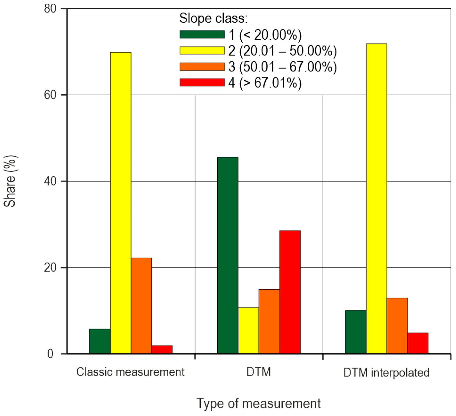
- Establish the possibility of estimating a cross terrain slope based on a non-interpolated digital terrain model (DTM) and interpolated digital terrain model with pixel size 15 × 15 m (we used the value at the nearest points for creating non-interpolated DTM);
- Define the carriageway value with minimum differences between cut and fill volumes;
- Determine which field factors take part in earthwork costs and their share in the total cost of a forest road construction.
2. Materials and Methods
2.1. Study Area
2.2. Analyzed Data and Used Programs
2.3. Field Data Processing in Microsoft Excel 2016
2.4. Field Data Processing in AutoCAD 2022 and ArcMap 10.8
3. Results
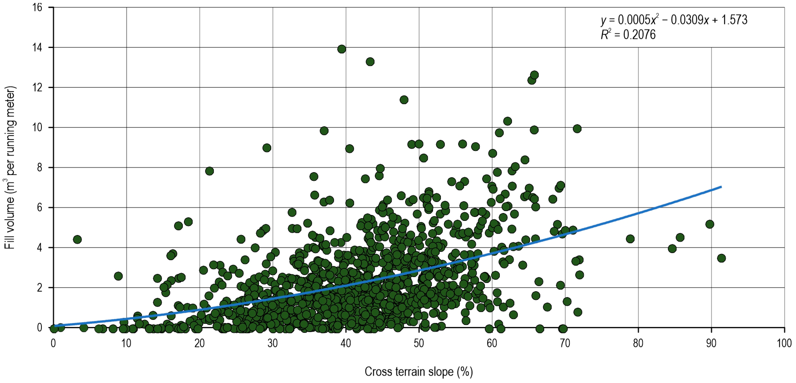
3.1. Impact of Cross Terrain Slope on Earthwork Volume
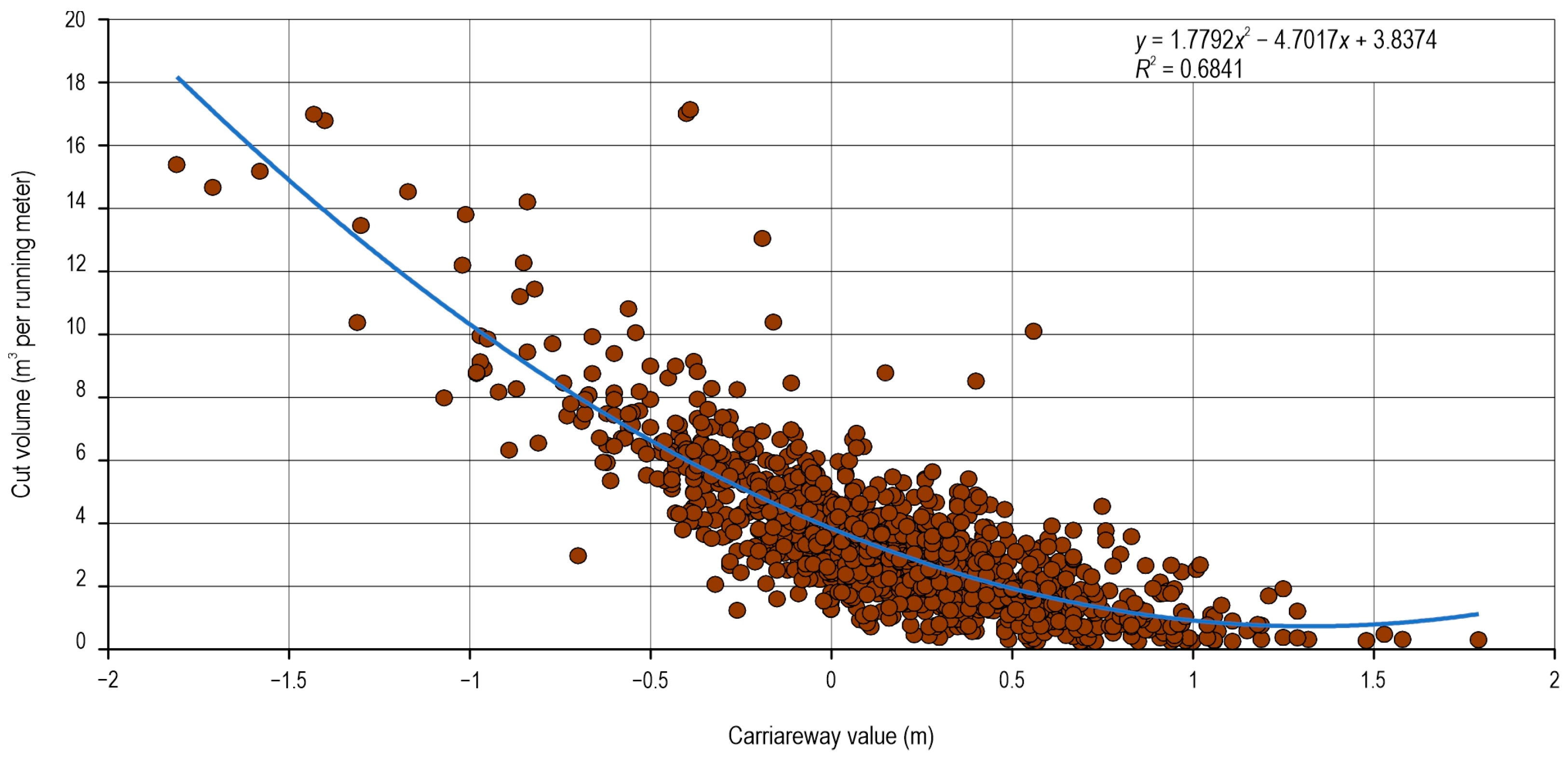
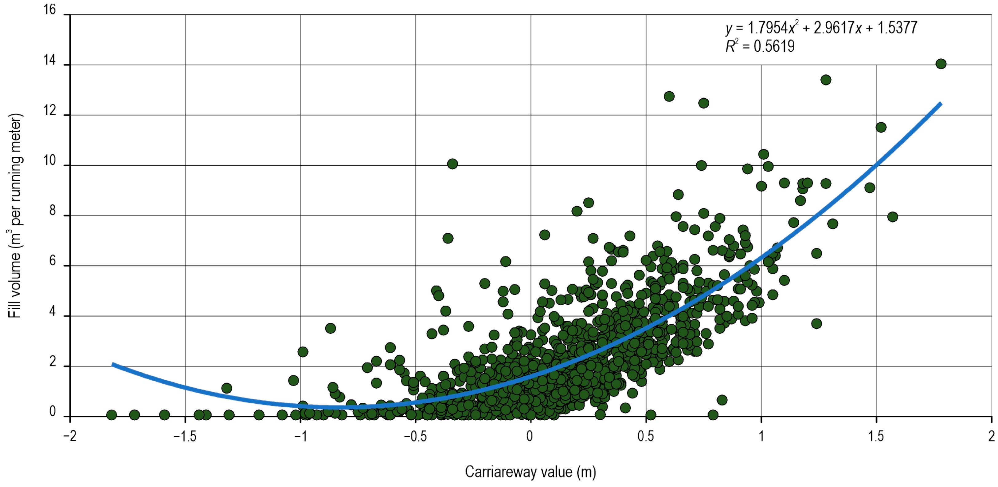
3.2. Impact of Depth of Carriageway on Earthwork Volume
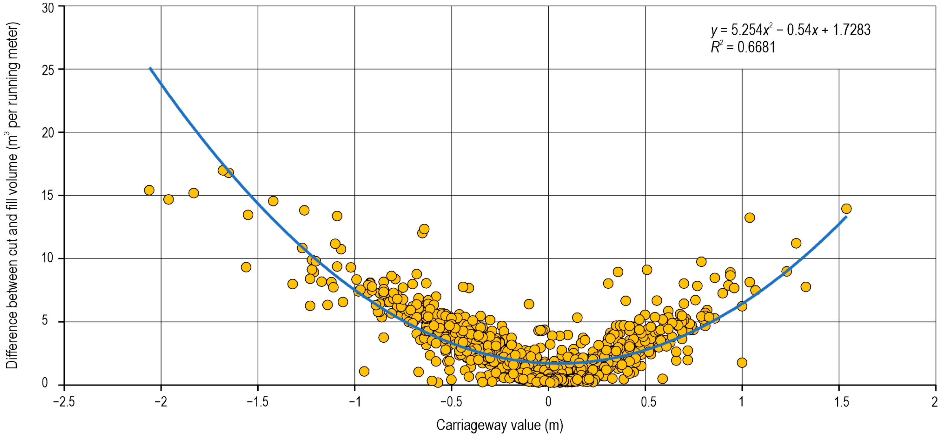
3.3. Optimal Carriageway Value
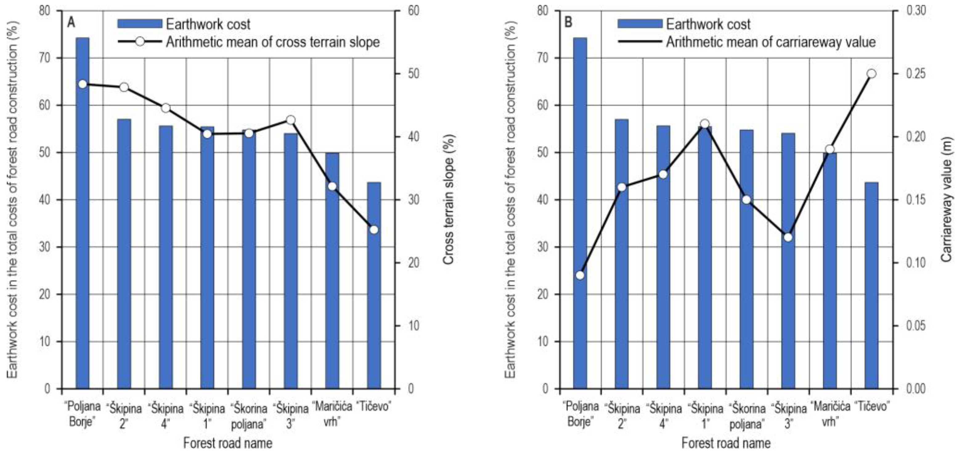
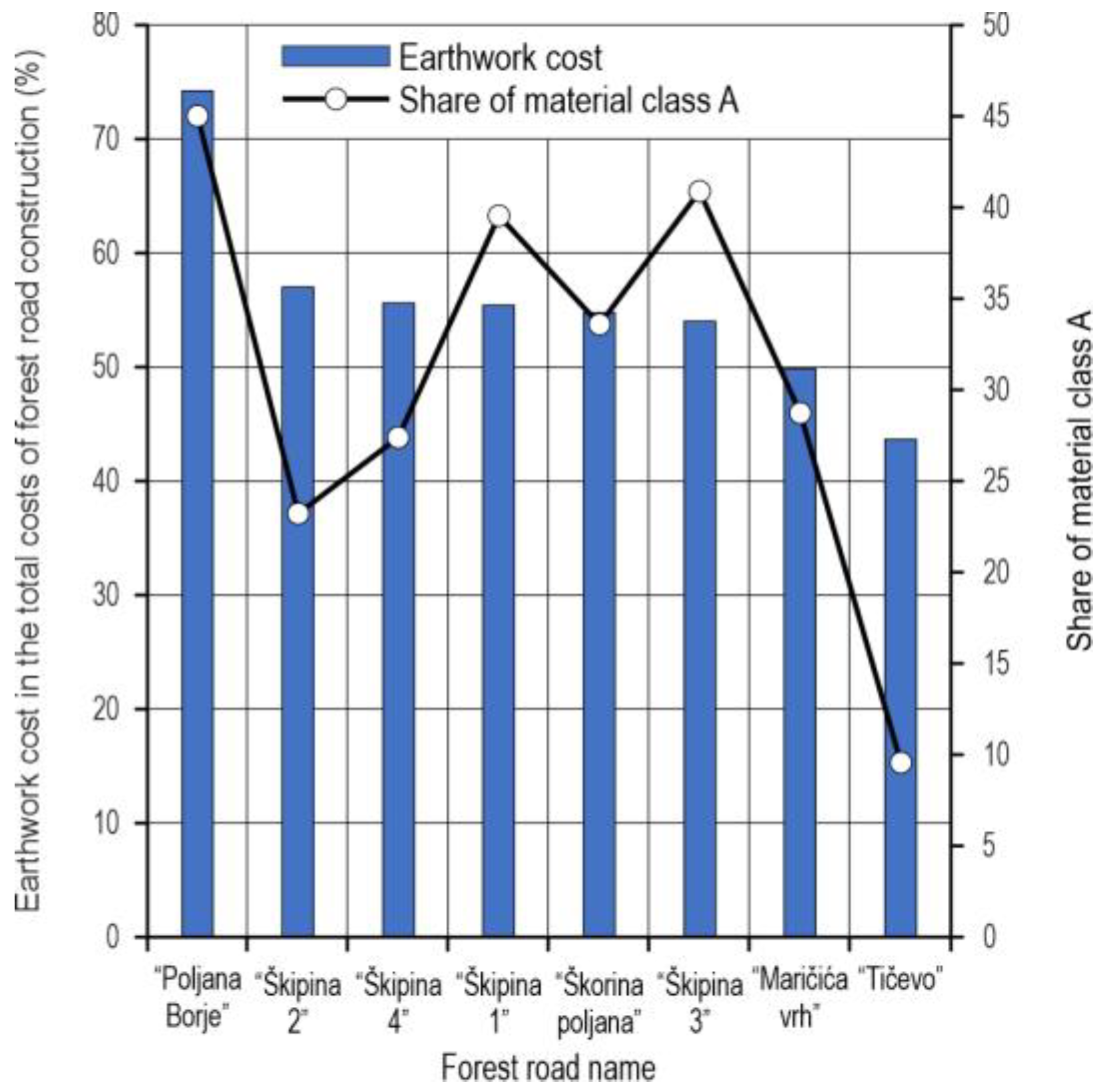
3.4. Share of Earthwork Cost in Total Cost of Forest Road Construction
4. Discussion
5. Conclusions
- Due to the direct impact of the earthwork volume on the total costs of forest road construction, which are very high, the optimization of earthworks should be the main focus of designers in each working phase that ends with developing the main forest road project and the construction of forest road. Based on experience and respecting the rules of the profession, the designer of a forest road can have a great impact on the carriageway value, and hence also the earthwork volume on a forest road route.
- It is improper and inaccurate to make an assessment of cross terrain slope values based on non-interpolated DTM and interpolated DTM with pixel size 15 × 15 m, because the obtained results are not accurate and reliable enough.
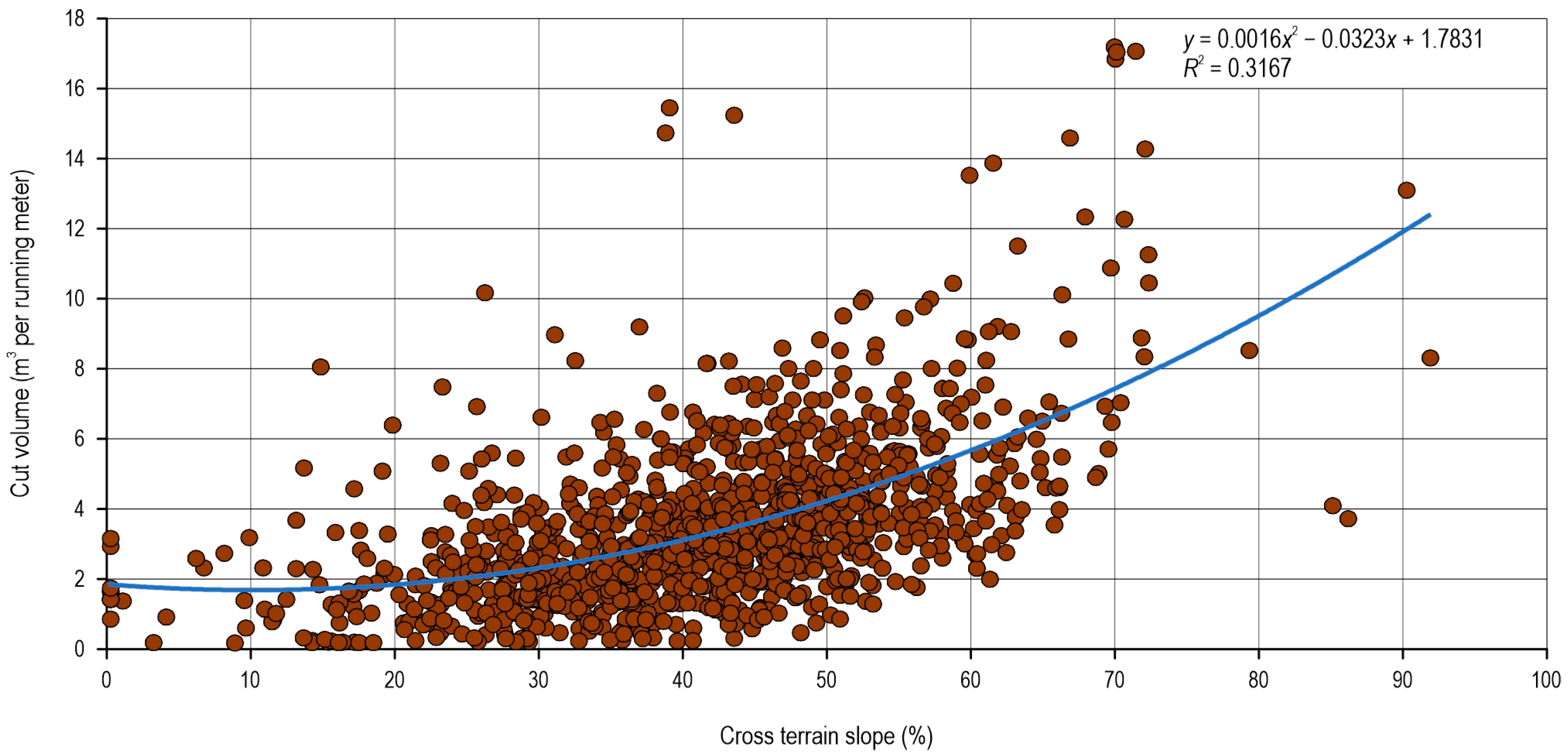
- Based on the coefficient of determination, it can be concluded that the impact of the cross terrain slope on the occurrence of cut and fill volume on the forest road route is moderate or weak, while the correlation between the carriageway value and the occurrence of cut and fill volume is determined as a moderate or strong correlation.
- The analyzed profiles involved a small number of profiles located on cross-section slopes greater than 67%; it is therefore necessary to undertake further research into earthwork occurrence on such terrain.
- The intent of providing maximum stability to forest roads on steep terrain inevitably causes a difference between the carriageway value, where the difference between the cut and fill volume is minimum, and the average actual carriageway value, in favor of the carriageway value, where the difference between the cut and fill volume is minimum.
- On moderate cross sections of the route with a lower share of material of the highest category, the designer has the greatest possibility to increase the carriageway value with the aim of minimizing the cut and hence also the damage to the forest ecosystem.
Author Contributions
Funding
Data Availability Statement
Acknowledgments
Conflicts of Interest
References
- Heinimann, H.R. Forest road network and transportation engineering–state and perspectives. Croat. J. For. Eng. 2017, 38, 155–173. [Google Scholar]
- Picchio, R.; Pignatti, G.; Marchi, E.; Latterini, F.; Benanchi, M.; Foderi, C.; Venanzi, R.; Verani, S. The application of two approaches using GIS technology implementation in forest road network planning in an Italian mountain setting. Forests 2018, 9, 277. [Google Scholar] [CrossRef]
- Akay, A.E.; Serin, H.; Sessions, J.; Bilici, E.; Pak, M. Evaluating the effects of improving forest road standards on economic value of forest products. Croat. J. For. Eng. 2021, 42, 245–258. [Google Scholar] [CrossRef]
- Pentek, T.; Pičman, D.; Nevečerel, H. Uspostava optimalne mreže šumskih cesta na terenu—smjernice unapređenja pojedine faze rada. Glas. Za Šumske Pokuse 2006, 5, 647–663. [Google Scholar]
- Pentek, T.; Pičman, D.; Nevečerel, H. Environmental-ecological component of forest road planning and designing. In Proceedings of the International Scientific Conference: Forest Constructions and Ameliorations in Relation to the Natural Environment, Zvolen, Slovakia, 16–17 September 2004. [Google Scholar]
- Kramer, B.W. Road construction and reconstruction. In Forest Road Contracting, Construction, and Maintenance for Small Forest Woodland Owners, 1st ed.; Oregon State University, College of Forestry, Forest Research Laboratory: Corvallis, OR, USA, 2001; pp. 24–42. [Google Scholar]
- Anonymous. Forest Road Engineering Guidebook, 2nd ed.; Forest Practices Code of British Columbia Guidebook: Victoria, BC, Canada, 2002. [Google Scholar]
- Ryan, T.; Phillips, H.; Ramsay, J.; Dempsey, J. Forest Road Manual: Guidelines for the Design, Construction and Management of Forest Roads, 1st ed.; COFORD: Dublin, Ireland, 2004; pp. 65–128. [Google Scholar]
- Adams, P.W.; Storm, R. Roads and stream crossings. In Oregon’s Forest Protection Laws, 2nd ed.; Oregon Forest Resources Institute: Portland, OR, USA, 2011; pp. 102–130. [Google Scholar]
- Anonymous. New Zealanad Forest Road Engineering Manual, 1st ed.; NZ Forest Owners Association: Welington, New Zealand, 2012. [Google Scholar]
- Marie, M.K.; Adam, W.; Zbigniew, B. Effects of forest roads on oak trees via cervid habitat use and browsing. For. Ecol. Manag. 2018, 424, 378–386. [Google Scholar] [CrossRef]
- Berenji Tehrani, F.; Majnounian, B.; Abdi, E.; Amiri, G.Z. Impacts of forest road on plant species diversity in a Hyrcanian forest, Iran. Croat. J. For. Eng. 2015, 36, 63–71. [Google Scholar]
- Çalişkan, E.; Karahalil, U. Evaluation of forest road network and determining timber extraction system using GIS: A case study in Anbardağ planning unit. Šumarski List 2017, 141, 163–171. Šumarski List 2017, 141, 163–171. [Google Scholar] [CrossRef]
- Borowski, Z.; Bartoń, K.; Gil, W.; Wójcicki, A.; Pawlak, B. Factors affecting deer pressure on forest regeneration: The roles of forest roads, visibility and forage availability. Pest Manag. Sci. 2021, 77, 628–634. [Google Scholar] [CrossRef] [PubMed]
- Picchio, R.; Tavankar, F.; Venanzi, R.; Lo Monaco, A.; Nikooy, M. Study of forest road effect on tree community and stand structure in three Italian and Iranian temperate forests. Croat. J. For. Eng. 2018, 39, 57–70. [Google Scholar]
- Lacerte, R.; Leblond, M.; St-Laurent, M.H. End of the road: Short-term responses of a large mammal community to forest road decommissioning. J. Nat. Conserv. 2022, 69, 126256. [Google Scholar] [CrossRef]
- Fu, B.; Newham, L.T.; Ramos-Scharrón, C.E. A review of surface erosion and sediment delivery models for unsealed roads. Environ. Model. Softw. 2010, 25, 1–14. [Google Scholar] [CrossRef]
- Grace, J.M., III. Predicting forest road surface erosion and storm runoff from high-elevation sites. Trans. ASABE 2017, 60, 705–719. [Google Scholar] [CrossRef]
- Deljouei, A.; Sadeghi, S.M.M.; Abdi, E.; Bernhardt-Römermann, M.; Pascoe, E.L.; Marcantonio, M. The impact of road disturbance on vegetation and soil properties in a beech stand, Hyrcanian forest. Eur. J. For. Res. 2018, 137, 759–770. [Google Scholar] [CrossRef]
- Jalali, A.M.; Naghdi, R.; Ghajar, I. Potential Evaluation of Forest Road Trench Failure in a Mountainous Forest, Northern Iran. Croat. J. For. Eng. 2022, 43, 169–184. [Google Scholar] [CrossRef]
- Lane, P.N.; Sheridan, G.J. Impact of an unsealed forest road stream crossing: Water quality and sediment sources. Hydrol. Process. 2002, 16, 2599–2612. [Google Scholar] [CrossRef]
- Robinson, C.; Duinker, P.N.; Beazley, K.F. A conceptual framework for understanding, assessing, and mitigating ecological effects of forest roads. Environ. Rev. 2010, 18, 61–86. [Google Scholar] [CrossRef]
- Kleinschroth, F.; Healey, J.R. Impacts of logging roads on tropical forests. Biotropica 2017, 49, 620–635. [Google Scholar] [CrossRef]
- Şakar, D.; Aydin, A.; Akay, A.E. Essential Issues Related to Construction Phases of Road Networks in Protected Areas: A Review. Croat. J. For. Eng. 2022, 43, 219–237. [Google Scholar] [CrossRef]
- Mansouri, S.; Nasiri, M.; Modarres, A. Technical and Environmental Impacts of Coal Waste Used as a Soil Stabilizer in Construction Projects of Forest Roads. Croat. J. For. Eng. 2021, 42, 491–500. [Google Scholar] [CrossRef]
- Solgi, A.; Naghdi, R.; Zenner, E.K.; Hemmati, V.; Behjou, F.K.; Masumian, A. Evaluating the effectiveness of mulching for reducing soil erosion in cut slope and fill slope of forest roads in Hyrcanian Forests. Croat. J. For. Eng. 2021, 42, 259–268. [Google Scholar] [CrossRef]
- Caliskan, E. Environmental impacts of forest road construction on mountainous terrain. Iran. J. Environ. Health Sci. Eng. 2013, 10, 23. [Google Scholar] [CrossRef] [PubMed]
- Epstein, R.; Weintraub, A.; Sessions, J.; Sessions, B.; Sapunar, P.; Nieto, E.; Bustamante, F.; Musante, H. PLANEX: A system to identify landing locations and access. In Proceedings of the International Mountain Logging and 11th Pacific Northwest Skyline Symposium College of Forestry, Seattle, WA, USA, 10–12 December 2001. [Google Scholar]
- Douglas, R.A. Road construction. In Low-Volume Road Engineering: Design, Construction, and Maintenance, 1st ed.; CRC Press: Boca Raton, FL, USA, 2016; p. 256. [Google Scholar] [CrossRef]
- Anonymous. Estimating road construction unit cost. In Cost Control in Forest Harvesting and Road Construction; FAO: Rome, Italy, 1992. [Google Scholar]
- Anonymous. Potpora za Ulaganja u Infrastrukturu Vezano uz Razvoj, Modernizaciju i Prilagodbu Poljoprivrede i Šumarstva. Tipa Operacije 4.3.3. Ulaganje u Šumsku Infrastrukturu iz Programa Ruralnog Razvoja Republike Hrvatske za Razdoblje 2014–2020. In Pravilnik o Provedbi Mjere M04 Ulaganja u Fizičku Imovinu Podmjere 4.3.; Narodne novine broj 106/15. 65/17. 77/17. 84/18; Government of Croatia: Zagreb, Croatia, 2015. [Google Scholar]
- Ghajar, I.; Najafi, A.; Karimimajd, A.M.; Boston, K.; Ali Torabi, S. A program for cost estimation of forest road construction using engineer’s method. For. Sci. Technol. 2013, 9, 111–117. [Google Scholar] [CrossRef]
- Bruce, J.C.; Han, H.S.; Akay, A.E.; Chung, W. ACCEL: Spreadsheet-based cost estimation for forest road construction. West. J. Appl. For. 2011, 26, 189–197. [Google Scholar] [CrossRef] [Green Version]
- Pearce, J.K. Construction Engineering and Inspection. In Forest Engineering Handbook, 1st ed.; A Guide for Logging Planning and Forest Road Engineering; Bureau of Land Management: Washington, DC, USA; Oregon State Office: Corvallis, OR, USA; US Department of the Interior: Portland, OR, USA, 1961; pp. 209–220. [Google Scholar] [CrossRef]
- Martinić, I. Ekonomski i Organizacijski Kriteriji za Oblikovanje Šumskih Radova. Ph.D. Thesis, Šumarski Fakultet Sveučilišta u Zagrebu, Zagreb, Croatia, 1995. [Google Scholar]
- Sessions, J. Forest Road Construction. In Forest Road Operations in the Tropics, 1st ed.; Springer: Berlin/Heidelberg, Germany; New York, NY, USA, 2007; pp. 83–106. [Google Scholar] [CrossRef]
- Stückelberger, J.A.; Heinimann, H.R.; Burlet, E.C. Modeling spatial variability in the life-cycle costs of low-volume forest roads. Eur. J. For. Res. 2006, 125, 377–390. [Google Scholar] [CrossRef]
- Jeličić, V. Korištenje Dozera na Izgradnji Šumskih Puteva. Ph.D. Thesis, Šumarski Fakultet Univerziteta u Sarajevu, Sarajevo, Yugoslavia, 1975. [Google Scholar]
- Potocnik, I. Depth of carriageway and cut slopes on forest roads. In Proceedings of the Zeszyty Naukowe Akademii Rolniczej w Krakowie, Sesja Naukowa, 91, Krakow, Poland, 15–18 June 2005. [Google Scholar]
- Sokolović, D.; Bajrić, M. Volumen zemljanih radova pri izgradnji šumskih cesta na strmim terenima. Nova Meh. Šumarstva: Časopis Za Teor. I Praksu Šumarskoga Inženjerstva 2015, 36, 33–42. [Google Scholar]
- Anonymous. Opći Tehnički Uvjeti za Radove na Cestama, 1st ed.; Book II—Zemljani radovi. odvodnja. potporni i obložni zidovi; Institut Građevinarstva Hrvatske: Zagreb, Croatia, 2001; p. 156. [Google Scholar]
- Moeini, M. Applied algorithm hourly rate analysis of construction equipments. In Proceedings of the First International Conference of Project Management, Tehran, Iran, 27 June–1 July 2004. [Google Scholar]
- Nevečerel, H. Dizajniranje Teorijskog Modela i Izrada Računalnog Programa za Projektiranje Šumskih Prometnica. Ph.D. Thesis, Šumarski Fakultet Sveučilišta u Zagrebu, Zagreb, Croatia, 9 December 2010. [Google Scholar]
- Jeličić, V. Šumske Ceste i Putevi, 1st ed.; Samoupravna Interesna Zajednica Odgoja i Usmjerenog Obrazovanja Šumarstva i Drvne Industrije: Zagreb, Croatia, 1983; p. 193. [Google Scholar]
- Anonymous. Izmijenjena i Dopunjena Metodologija Izrade Registra Šumskih Cesta; (DIR-01-2008-1705/01); Government of Croatia: Zagreb, Croatia, 2008. [Google Scholar]
- Chaddock, R.E. Principles and Methods of Statistics, 1st ed.; Houghton Miffin Company: Boston, MA, USA; The Riverside Press: Cambridge, UK, 1925; pp. 248–303. [Google Scholar]
- Akgul, M.; Yurtseven, H.; Gulci, S.; Akay, A.E. Evaluation of UAV-and GNSS-based DEMs for earthwork volume. Arab. J. Sci. Eng. 2018, 43, 1893–1909. [Google Scholar] [CrossRef]
- Saarilahti, M. Modeling of the Wheel and Soil. In Development of a Protocol for Coefficient Wood Harvesting on Sensitive Sites; Soil interaction model, Apendinx Report no. 8; Ecowood: Oradea, Romania, 2022; pp. 1–37. [Google Scholar]


| Forest Road Code | Forest Road Name | Stationing (hm) | Number of Profiles in Total | Number of Analyzed Profiles (Pavement Width 3.5 m) |
|---|---|---|---|---|
| 646 B 3015 | “Poljana Borje” | 23 + 43.44 | 257 | 162 |
| 646 B 3016 | “Maričića vrh” | 23 + 07.50 | 231 | 167 |
| 646 B 3017 | “Škipina 1” | 15 + 99.85 | 163 | 134 |
| 646 B 3018 | “Škipina 2” | 15 + 13.43 | 161 | 138 |
| 646 B 3019 | “Škipina 3” | 25 + 38.89 | 266 | 198 |
| 646 B 3020 | “Škipina 4” | 20 + 11.00 | 211 | 157 |
| 646 B 3021 | “Škorina poljana” | 16 + 71.57 | 167 | 134 |
| 646 B 3022 | “Tičevo” | 08 + 93.55 | 90 | 63 |
| TOTAL | 148 + 79.23 | 1546 | 1153 | |
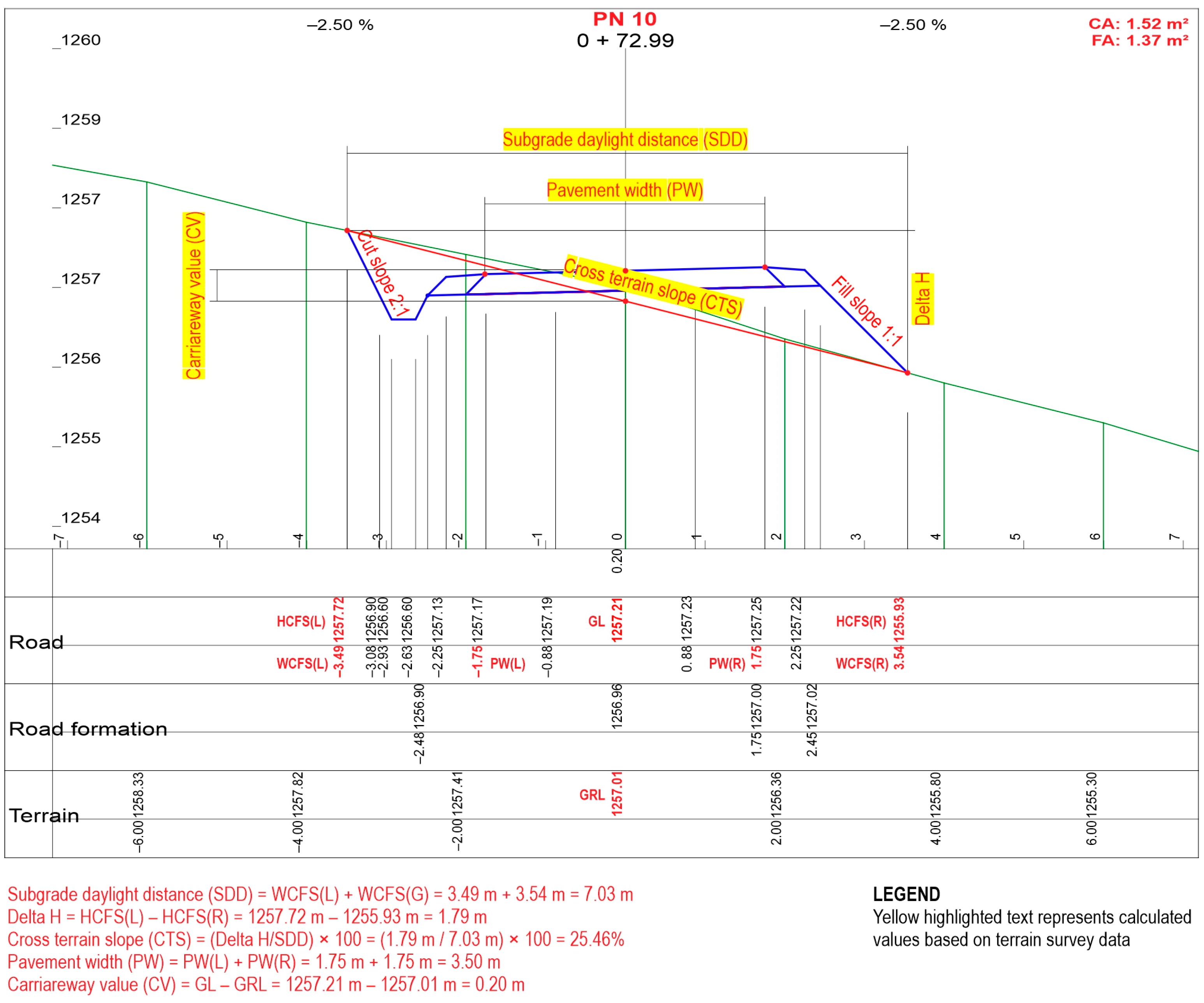
| NP | WCFS(L) (m) | HCFS(L) (m) | WCFS(R) (m) | HCFS(R) (m) | SDD (m) | Delta H (m) | CTS (%) | PW(L) (m) | PW(R) (m) | PW (m) | GL (m) | GRL (m) | CV (m) | FS | CS | CA (m3 per Running Meter) | FA (m3 per Running Meter) |
|---|---|---|---|---|---|---|---|---|---|---|---|---|---|---|---|---|---|
| 8 | 3.67 | 1259.73 | 3.12 | 1258.01 | 6.79 | 1.72 | 25.33 | 1.75 | 1.75 | 3.50 | 1258.88 | 1258.64 | 0.24 | 1:1 | 2:1 | 2.00 | 0.74 |
| 9 | 3.69 | 1258.95 | 3.46 | 1256.84 | 7.15 | 2.11 | 29.51 | 1.75 | 1.75 | 3.50 | 1258.04 | 1257.88 | 0.16 | 1:1 | 2:1 | 2.36 | 1.13 |
| 10 | 3.49 | 1257.72 | 3.54 | 1255.93 | 7.03 | 1.79 | 25.46 | 1.75 | 1.75 | 3.50 | 1257.21 | 1257.01 | 0.20 | 1:1 | 2:1 | 1.52 | 1.37 |
| 11 | 3.34 | 1256.73 | 3.74 | 1255.04 | 7.08 | 1.69 | 23.87 | 1.75 | 1.75 | 3.50 | 1258.52 | 1255.89 | 2.63 | 1:1 | 2:1 | 0.58 | 2.68 |
| Slope Class | Number of Analyzed Cross Sections | Share of Slope Class (%) |
|---|---|---|
| 1 (<20.00%) | 67 | 5.81 |
| 2 (20.01–50.00%) | 806 | 69.90 |
| 3 (50.01–67.00%) | 257 | 22.29 |
| 4 (>67.01%) | 23 | 1.99 |
| Statistical Parameters | Cross Terrain Slope (%) | Carriageway Value (m) | Cut Volume (m3 per Running Meter) | Fill Volume (m3 per Running Meter) | Difference between Cut and Fill Volume (m3 per Running Meter) |
|---|---|---|---|---|---|
| Arithmetic mean | 41.35 | −0.09 | 3.47 | 2.37 | 2.79 |
| Median | 42.53 | −0.09 | 3.05 | 1.89 | 2.18 |
| Modus | 0.00 | −0.25 | 1.27 | 0.00 | 1.27 |
| Standard deviation | 13.16 | 0.43 | 2.37 | 2.06 | 2.43 |
| Minimum value | 0.00 | −2.06 | 0.16 | 0.00 | 0.01 |
| Maximum value | 91.83 | 1.54 | 17.12 | 14.15 | 16.97 |
| Number of analyzed profiles | 1153 | 1153 | 1153 | 1153 | 1153 |
| “Poljana Borje” | “Škipina 2” | “Škipina 4” | “Škipina 1” | “Škorina Poljana” | “Škipina 3” | “Maričića Vrh” | “Tičevo” | |
|---|---|---|---|---|---|---|---|---|
| Preparatory work (%) | 4.93 | 8.21 | 7.87 | 7.16 | 7.91 | 7.57 | 9.03 | 11.66 |
| Earthworks (%) | 64.44 | 49.97 | 49.68 | 52.80 | 52.26 | 50.40 | 46.97 | 36.24 |
| Drainage system construction (%) | 9.79 | 7.03 | 5.95 | 2.64 | 2.49 | 3.63 | 2.88 | 7.39 |
| * Earthworks ALL (%) | 74.22 | 57.00 | 55.62 | 55.44 | 54.75 | 54.03 | 49.85 | 43.63 |
| Surfacing (%) | 20.85 | 34.79 | 36.51 | 37.40 | 37.34 | 38.39 | 41.13 | 44.71 |
| Arithmetic mean of cross terrain slope (%) | 48.33 | 47.84 | 44.52 | 40.43 | 40.54 | 42.64 | 32.12 | 25.24 |
| Material Category | “Poljana Borje” | “Škipina 2” | “Škipina 4” | “Škipina 1” | “Škorina Poljana” | “Škipina 3” | “Maričića Vrh” | “Tičevo” |
|---|---|---|---|---|---|---|---|---|
| B | 89 | 106 | 114 | 81 | 89 | 117 | 119 | 57 |
| A | 73 | 32 | 43 | 53 | 45 | 80 | 48 | 6 |
| B (%) | 54.94 | 76.81 | 72.61 | 60.45 | 66.42 | 59.09 | 71.26 | 90.48 |
| A (%) | 45.06 | 23.19 | 27.39 | 39.55 | 33.58 | 40.91 | 28.74 | 9.52 |
Disclaimer/Publisher’s Note: The statements, opinions and data contained in all publications are solely those of the individual author(s) and contributor(s) and not of MDPI and/or the editor(s). MDPI and/or the editor(s) disclaim responsibility for any injury to people or property resulting from any ideas, methods, instructions or products referred to in the content. |
© 2023 by the authors. Licensee MDPI, Basel, Switzerland. This article is an open access article distributed under the terms and conditions of the Creative Commons Attribution (CC BY) license (https://creativecommons.org/licenses/by/4.0/).
Share and Cite
Papa, I.; Picchio, R.; Lovrinčević, M.; Janeš, D.; Pentek, T.; Validžić, D.; Venanzi, R.; Đuka, A. Factors Affecting Earthwork Volume in Forest Road Construction on Steep Terrain. Land 2023, 12, 400. https://doi.org/10.3390/land12020400
Papa I, Picchio R, Lovrinčević M, Janeš D, Pentek T, Validžić D, Venanzi R, Đuka A. Factors Affecting Earthwork Volume in Forest Road Construction on Steep Terrain. Land. 2023; 12(2):400. https://doi.org/10.3390/land12020400
Chicago/Turabian StylePapa, Ivica, Rodolfo Picchio, Mihael Lovrinčević, David Janeš, Tibor Pentek, Dino Validžić, Rachele Venanzi, and Andreja Đuka. 2023. "Factors Affecting Earthwork Volume in Forest Road Construction on Steep Terrain" Land 12, no. 2: 400. https://doi.org/10.3390/land12020400