1. Introduction
In the context of the increasing dependence on Information and Communication Technologies (ICT) in our society, advances in the field of mobile technology in the last two decades have led to the dissemination of devices with components designed to offer varied applications. Their use has profoundly transformed social habits in terms of accessing online information, as well as processing, editing, sharing and downloading online content [
1]. Among the possibilities offered by mobile devices, smartphones and tablets, those related to Augmented Reality (AR) are of particular interest. AR is a technology that complements and enriches the live view of a real space with virtual elements, composed of graphic and text materials, which are activated through a mobile device [
2,
3,
4,
5,
6,
7,
8,
9]. The act of being able to take advantage of its benefits in key sectors such as medicine, design or education has increased the interest in AR in recent times, although its development has been ongoing since the last century [
10,
11].
Among the applications with the greatest social impact, educational applications are of particular interest because they have been demonstrated to enhance the efficiency of the teaching–learning process since the devices are commonly used among students to communicate and interact [
12]. Moreover, educational applications of AR promote meaningful learning of curricular content by involving the learner in the interactive and self-guided exploration and recognition of those Points of Interest (POIs) selected by the teacher [
13,
14]. Visited in isolation, these POIs function as ‘geosites’. When combined in sequence (POI 1 to POI 9), these POIs function as a ‘geotrail’; when viewed as an ensemble, POIs combine to be similar to a ‘geopark’ that, in this case, emphasises glacial and periglacial landscapes and sedimentary deposits. The experience enriched by virtual components includes the capacity to adapt information to the different levels of understanding and needs of students and tourists, therefore making it possible to reinforce various aspects of contents, in a particular way that results in the greater assimilation of information [
14,
15]. Elements that heighten the assimilation of content such as interaction on virtual platforms can also be added [
8,
16,
17,
18]. AR is a reliable tool for teaching important elements which can be customized for use in any educational framework, related to the sustainable enjoyment of the environment [
8]. Additionally, this extends to planned outdoor educational practices. Educational applications of AR can help to reduce group pressure on fragile natural resources by reducing potential site damage by student and tourist access and facilitate the knowledge of areas that are not easily accessible, due to the superimposition of the virtual component on the real scenario.
Activation can occur, according to Prendes Espinosa [
19], in the following four diverse ways: by barcode recognition or Quick Response (QR) through the camera of the mobile device; through predefined markers on images or objects; by taking advantage of elements of the device such as Global Positioning System (GPS), gyroscope, accelerometer, a compass, or others that facilitate a total contextualisation.
Prendes [
19] described four diverse ways by which educational experiences can be activated, which are as follows:
By barcode recognition or Quick Response (QR);
Through the camera of the mobile device;
Through predefined markers on images or objects;
By taking advantage of elements of the device such as Global Positioning System (GPS), gyroscope, accelerometer, a compass, or other devices that facilitate a total contextualisation.
This case study focused on the composition of virtual elements that illustrate educational training content involving panoramic views, animated videos and 3D models. These were activated and visualized through devices that are largely available at academic institutions. However, it is a task that has to be coordinated with the more strictly technological ones, given that the materials have to be adapted to the technical characteristics of the desired application, taking into account aspects such as design and usability [
14].
To develop a sequence of experiences based on AR with an academic purpose, this work developed a pioneering project in the San Isidro pass, a mountain range located in the north-west of the Iberian Peninsula, specifically, in the central-eastern sector of the Cantabrian Mountain range (
Figure 1). It was proposed as a useful pedagogical tool for field practices in the Geography and Regional Planning degree at the University of Oviedo, more specifically within the framework of the subject of Landforms Dynamics (compulsory in the Third Undergraduate Year). The chosen educational perspective relates to the approaches of the official Geography degree in the region. We adopted an official teaching framework in which the application of distinctive features of the study area is useful and exemplifies the link between general contents of university subjects and academic fieldwork. On the other hand, the aims of the Department of Geography in our university underline the value of contributing to the knowledge of the region for its development.
San Isidro is a mountain area which is particularly interesting for understanding the importance of glacial and nivoperiglacial processes in the current configuration of the relief of the Cantabrian Mountain range. At the same time, it allows us to gauge the importance of anthropic landscape alterations. Changes have been linked to the development of leisure and sporting activities, which have caused significant degradation of these spaces which are often difficult to reverse.
The objective of presenting a didactic proposal based on AR was also based on its coherence with the purposes of the university bachelor’s degree, considering the general and specific competences (GC and SC) as well as the learning outcomes (LO) (
Table 1):
AR can be used to enhance the autonomous learning experience in an environment that exemplifies the geological and geomorphic evolution of the Cantabrian high mountains; however, its complete geomorphic and landscape interpretation requires adapted, dynamic and attractive interactive materials. The content of AR is articulated around an itinerary that links, in addition to the internal structure as the framework of the relief, those forms of relief and the correlative surface formations corresponding to the different modelling systems that have acted on this area of the Cantabrian Mountain range. These features are visualised by the teacher and the students through interactive graphic and textual materials. The project sought to conceive of a way of approaching and interpreting geomorphic and landscape features to complement the classic methods of recognition in situ or using classroom materials.
Those tools could be used by public and private entities as a product suitable for regulated university teaching but also could guide other geoeducational actions or institutional work for official heritage recognition. In institutional actions, a perspective of tourism use could be integrated as a factor for socio-economic and cultural development in relation to the conservation and dissemination of geologic and geomorphic attributes. In fact, educational initiatives can be integrated, through collaboration with the public administration or other entities, in combined programs for conservation, citizen education (with an adapted curricular design for a wide public) and sustainable development with a tourist aspect that promotes knowledge and understanding of natural phenomena and human interaction.
Much of this paper provides an in-depth description of the geology, geomorphology, and processes leading to the formation of the region; this description is the basis for the background information for geotourists and students to appreciate the natural history of the Cantabrian Mountain range visually and through AR. A suggested itinerary through the mountain pass is presented in the section titled ‘Geologic and geomorphological itinerary through San Isidro Mountain pass’ and various key sites prefixed/labelled as ‘POI’ provide a detailed itinerary through this region.
2. Study Area
The mountainous area formed by the San Isidro pass depression and the two quartzite–calcareous alignments that frame it to the north and south are located on the watershed between the Cantabrian and Atlantic slopes, with the Contorgán passes to the northwest, the Vegarada Pass to the south, and the Señales and Tarna mountain passes to the east. It is an area of special interest, as the low incidence of Pliocene and Quaternary fluvial erosion has favored the preservation of a great diversity of relief forms.
Among these geomorphic features, the oldest are the remnants of erosion ramps belonging to the bottom of an ancient trough valley that followed the Hercynian structural controls. These remains, together with the slopes regularised by accumulation, were cut, specially on the shady slopes, by the erosive processes triggered by Pleistocene glacial erosion. Later, the transition to periglacial climatic conditions completed the already varied range of existing forms. The spatial association between the rock glaciers and the snow moraines on the northern slopes of the Sentiles mountain range are particularly interesting (
Figure 2 and
Figure 3).
3. Materials and Methods
To develop the proposal for the application of AR in the San Isidro Mountain pass and the northern slope of the Sierra de Sentiles, a methodology comprising both desk and fieldwork was followed (
Figure 4). It began with a bibliographical review on the importance of ICT and the usefulness of AR for diversifying and reinforcing university teaching, particularly in Physical Geography subjects. In addition, different types of sources were reviewed. Firstly, bibliographic sources in the fields of geology, geomorphology and landscape analysis; secondly, dossiers of field practices. Cartographic and photographic archives were consulted to identify graphic and audiovisual materials (historical cartography, historical vertical and terrestrial aerial photography, etc.) that represent and explain the key elements of the study area. In this sense, it is worth highlighting the existence of previous studies specifically contextualised in this sector of the Cantabrian Mountain range as providing essential support for this work. In addition, their detailed geomorphological cartography served as a starting point for the images included in this text [
21,
22].
Subsequently, the POIs to be included in the itinerary were selected during several days of fieldwork. The proposed route combines a vehicle section (15.3 km on the AS-253 access road to the San Isidro pass from the Asturian side and the deviation towards the Cebolledo Valley in León), and a walking section (4.2 km along the track that leads from the base of the San Isidro ski resort to the Ausente lake). In the first part, which starts shortly before the village of Cuevas, five stops were selected, considering both the availability of safe places to park, and the fact that the points indicated are excellent viewpoints from which to explore the geomorphic components of this mountain landscape. In the second section, i.e., the section on foot, although four stops are also indicated, the geomorphological explanation is more of a continuum along the route, allowing for a more leisurely observation of the relief, which is essential to understand the complex association of glacial and periglacial forms.
In accordance with the systematic bibliographical review carried out on this sector of the Cantabrian Mountains and considering the objectives and learning outcomes to be pursued in the subject, special emphasis was placed on interpreting the morphostructural configuration of the San Isidro pass, specifically on highlighting the importance of the Appalachian style of structural forms. It is this issue that determines, in the first instance, the general physiognomy of this mountainous group. Secondly, the characterisation of the main glacial landforms was addressed, underlining their close relationship with local conditioning factors (altitude, orientation, previous morphology, internal structure, etc.) which, in our opinion, determine the general physiognomy of this mountain range. Similarly, the importance of past and current snow and ice forms in this area is highlighted, focusing on explaining the distribution of snow moraines and rock glaciers as well as the important incidence of snow avalanches. Finally, another important aspect of this analysis is the detailed assessment of the anthropic actions conducted in recent decades, linked to the development of leisure and sporting activities, which led to a significant degradation of this area, specially in the area surrounding the San Isidro ski resort. Those competences and learning outcomes of the official subject that are addressed through the contents along the itinerary are indicated with alphanumeric coding in each POI heading.
To highlight each POI, texts were prepared in accordance with the content of the subject, giving prominence to the language and terms that form part of the learning standards within Physical Geography, and more specifically the aspects that relate to the configuration of the relief and its geomorphological dynamics. Along the same lines, the choice of graphic materials, some taken from previous sources and others made by the authors of the proposal (with Ricoh Theta V camera, GoPro Hero 9 camera), aimed to capture the student’s attention through interactivity, aesthetic singularity (as less traditional materials) and documentary value.
Using these graphic resources, various types of Figures were created in collaboration with Observatorio del Territorio of the University of Oviedo, including animated videos with sequences of texts, images and symbols; panoramic and spherical photos as virtual tours with labels and additional pop-up texts and/or images to highlight key features and processes; and rotating and expandable 3D models to show, in a synthetic way and from different angles, the structure and shape of the space being visited, thereby taking advantage of the three-dimensional view.
Regarding flyover or zoom animations, they can be generated directly from software such as Google Earth, QGIS or Agisoft. With regard to generating sequences of photographs, it is necessary for cut outs of the photographs with the area to be represented and, if required, georeferenced. Subsequently, they were converted into an animated sequence with digital editing software (in this case, Adobe Photoshop was used).
For the elaboration of virtual tours, we used 3Dvista with the photographs taken with a 360° camera, in which additional information is included. Further, three-dimensional models and elements can be obtained by using digital elevation or surface models in GIS programs (QGIS) to later export them to a 3D format (information sources such as LiDAR, Radar or others are used to generate the models). In this case, MDT 02 data provided by Spanish Instituto Geográfico Nacional were used. It is a digital model in its 2nd version (2015–current) with a resolution of 2 m.
AR resources can be activated along the journey using a QR code that can be scanned with the camera of a device
1. This code will be included as a key resource in a field dossier specifically prepared for the itinerary. The code directs users to the Onirix website, with which our research group collaborated [i]. The advantage of using Onirix is its development through WebAR, which allows AR resources to be displayed through web pages in such a way that the download of an application is not necessary. Once the website is activated using a common browser (both IOS and Android systems are supported), while still focusing the camera on each of the AR figures included in the dossier, the dynamic graphic content will be displayed. This content includes Figures 7–19 which complement other static, and all of them are to be included in the field dossier. The materials are hosted in the Observatorio del Territorio storage system at the University of Oviedo as well as in YouTube (videos) and Sketchfab (3D models) accounts.
4. Results
4.1. The Geologic and Geomorphologic Keys of San Isidro Mountain Pass
Rather than conducting a systematic description of the relief of the San Isidro mountain pass, the aim of this paper was to draw attention to those components which are most important from a geologic and geomorphic point of view and which, consequently, are essential to understand the appearance of the landscape today.
4.1.1. The Importance of the Internal Structure in the Organisation of the Relief
As already mentioned, understanding the organisation of the relief of the San Isidro pass, an area located at the south-eastern limit of the Central Carboniferous Basin and forming part of the so-called Mantos region, implies considering, first, the essential role played by nature and mode of arrangement of its materials. As in the rest of the Asturian Massif, the configuration of its morphostructural framework is the result of a long geological history. The geological traces are still recognisable in the general layout of the mountain alignments and the valleys that separate them. In this sense, it must be considered that, if the layout of the outcrops is a feature attributable to the Hercynian or Variscan Orogeny, an episode which took place at the end of the Carboniferous approximately 300 million years ago, the definitive configuration of the relief is largely the result of the internal pressures and movements which affected this space during the Cenozoic. The uplifting of the old Hercynian thrust scales was triggered by Alpine tectonics and, because of this, the beginning of a new cycle of excavation and evacuation of the most degradable materials represent the origin of the relief whose configuration could be described by experts as “pseudo-Appalachian”.
As a consequence of these internal dynamics, the rocky outcrops in this sector are arranged in parallel bands of contrasting strength, with a broad, massive base, composed of resistant Armorican quartzites; an intermediate, less thick, calcareous section; and a fundamentally slaty roof that is much less erosion-resistant and compact, in which variable thicknesses of limestone are interspersed. These lithologies and structures result in, with their elongated layout in the direction of the parallel strata, the cartographic outline of the thrust front of the Laviana and Rioseco klippes both belonging, together with the Tarna mantle, to the aforementioned Mantos region. The enhancement of this internal structure, and more specifically the highlighting of its lithological heterogeneity due to differential erosion, has given rise to a contrasting geomorphology. Outcrops of Ordovician quartzite form the framework of the external ridges, while the erosion of the internal slate core formed the opening of the wide depression of the San Isidro pass [
23].
This relative morphostructural simplicity is only altered by the presence of a large transverse fold, the San Isidro anticline. This is a tectonic feature which, in addition to the undulation in the planning of the outcrops, has caused a generalised vertical attitude of the thrust planes [
24], even determining, at the western end of the San Isidro anticline, an inversion in the inclination of the layers. It can be seen most clearly on its northern flank, that is, on the buttresses that form the summit of the Torres Peak.
In clear harmony with this internal structure is the organisation of the relief of the San Isidro pass, expressed as a ring of external quartzite ridges, open at its eastern end, but which encloses a spacious central depression that is slatey in nature and with an elongate longitudinal profile. This surrounding ring coincides in its southern part with the front of the Laviana mountain range, which in this sector is attached, except in the western edge of the pass, to the front end of the Rioseco scale. The intermediate calcareous–slatey materials are compressed between the two in their entirety. At many points exceeding two thousand metres in altitude, this elongated quartzite range is composed from east to west of the Ausente Peak (2041 m), the Peña de Requejines (2026 m), the Sentiles mountain range, Peña Agujas (2141 m), the Toneo Peak (2091 m), the Ajo mountain range, the Fuentes Peak (2021 m) and the Nogales Peak (2074 m), from where it continues, tracing the western closure of the San Isidro anticline through the Fuentes de Invierno Mountain range. Once the anticline closure is passed, the quartzite structural ridge described above splits into two branches on its northern flank, continuing along the one that forms the northern limit of the San Isidro pass. This corresponds to the front of the Rioseco scale, through the Torres Peak (2100 m), the Valmartín Peak (1932 m), the El Arenal Peak (1885 m) and Los Negros (1801 m). From here, the line of peaks extends eastwards through Peña del Viento (1992 m) and Las Rapaínas (2019 m) until it ends at Las Cuerdas Peak (1814 m), the eastern end of the surrounding ring.
In turn, delimited by these mountainous alignments, the San Isidro valley also extends in the direction of the parallel lithological trends, a wide slatey inlet modelled on the materials that form the lithostratigraphic roof of the Mantos region. Its slopes which are very steep at the top, are transformed as they descend towards the interior of the furrow into steep erosion ramps with a gentle slope and a flat top. These interfluves can be interpreted precisely due to their morphology and layout as the remains of an ancient and wide fluvial trough adapted to the layout of the Hercynian structures and subsequently cut by fluvial and glacial erosion.
Towards its western end, this valley is interrupted, in the place known as Riofrío, by an important break in the slope which has a more than 150 m of height difference and in which the San Isidro River has opened a narrow, deep gorge. On the eastern boundary, as on the opposite side, the upward action carried out by the tributaries of the Duero also cuts this structure transversally. It gives rise to the subdivision of the orthoclinal corridor into two minor valleys, crossed from north to south by the Pinzón stream and the river Isoba, between which the San Justo Peak (1955 m), with quartzite at its summit and calcareous at its base, is isolated.
4.1.2. The Significant Development of Glacial Landforms in the Southern Quartzite Alignment
According to the typology of the morphological glacial landforms of the Cantabrian Mountains proposed by Frochoso and Castañón [
25], the San Isidro pass falls into the category of “well-developed composite alpine-type glaciers” (
Figure 5 and
Figure 6), due, as these authors point out:
“[…] to a morphostructural set of ridges exceeding 2000 m and wide orthoclinal furrows located at around 1600 m which, without reaching the suitability of the glaciokarstic complexes, also favoured the accumulation of snow and ice, and the overflow of this both in the direction of the Cantabrian slope and towards the Duero slope”.
In the San Isidro pass, there must have existed during the phase of maximum extension of the Pleistocene glaciation two important diffluent tongues. Acting as general collectors, they collected the ice brought in from the secondary headwaters, forming what can therefore be described as compound alpine glaciers.
One of these tongues started from the glacial cirque formed at the foot of the Toneo Peak—it headed towards the Cantabrian slope, being fed on its way by the ice contributed from the juxtaposed cirques present on the northern slope of the Ajo mountain range. Taking advantage of the longitudinal profile of the old river valleys and respecting their previous configuration, this stream must have once reached the rocky threshold of Riofrío. Here, the glacial ice, forced to overcome the steep break in the slope at this point (more than 150 m), would break up in the form of seracs.
The other, larger tongue began in the great glacial cirque modelled between the Roldán and Peña Agujas Peaks, carving its way through the wide glacial trough of the Cebolledo furrow until it reached the main valley. It continued, turning eastwards and incorporating the ice from the Sentiles mountain range and the cirque located at the foot of Peña Requejines and the Ausente Peak, until it reached the Isoba lake. Here, the main artery described above forked, with the northern branch continuing along the valley of the river Isoba. Additionally, the southern branch, which was larger, continued along the valley of the Silván until it ended in the vicinity of the town of Puebla de Lillo, at around 1100 m above sea level. This is confirmed by the preservation of moraine deposits and large erratic blocks located there [
26,
27,
28].
This period of maximum glacial ice extension must have been followed, within the deglaciation process of the San Isidro pass, by a phase of disjunction of these glacial tongues. Hardly any clear moraine evidence remains, with the exception of a few small cordons located at mid-slope (1500–1600 m altitude) on the northern slope of the Sierra del Ajo or in the tributary valley of El Gumial, the latter located at the western end of the quartzite alignment, at the foot of the Nogales Peak at around a 1450 m altitude.
The next stage in this general glacial retreat, initiated after a long period of stabilisation of the glacial flows at the limits already indicated, would correspond to a residual stage of the deglaciation process, also known as the altitude stage. It is characterised, as in other places in the Cantabrian Mountain range [
29,
30], by the establishment of small glaciers or permanent ice fields in the better oriented headwaters and by the formation of numerous rock glaciers and snow moraines that mark the transition towards morphoclimatic conditions already periglacial in nature [
31].
However, despite the obvious importance of glacial forms in the San Isidro pass as a whole, it is necessary to emphasise the unequal distribution of the landforms belonging to this morphogenetic system, as observed in other parts of the Cantabrian Mountains [
32,
33]. The dissymmetry is undoubtedly attributable to local conditioning factors, such as altitude and the orientation of the slopes. The accumulation areas present a clear preference for the slopes exposed to the first quadrant, i.e., those more favourable, in relation to the blizzard effect, for the storage and conservation of snow. In this regard, it should not be forgotten that the very phenomenon of snowfall can be accompanied by intense winds that facilitate the concentration of thick blankets of snow on the leeward slopes, i.e., those facing east [
34]. These types of conditioning factors explain the marked contrast offered by the slopes of the mountain ranges bordering the San Isidro pass. The impact of glacial processes acted much more effectively on the shady slopes. Their surface has been cut out by well-drawn and coalescent glacial niches and cirques, which give the whole of this southern alignment a cut-out longitudinal profile.
In contrast to what can be seen on this slope, on the opposite or sunny side, and although the altitude is also above 1900 m in many places (Torres Peak, Valmartín Peak, Peña la Capilla, Peña los Fornos, Las Rapaínas, etc.), only small recesses can be seen on the other side of the mountain. Typical characteristics of snow niches or incipient glacial cirques can be appreciated here. The ice may have been concentrated in more or less extensive lenses, but without ever moving down the slope in the form of a tongue, thus preserving, with greater continuity, the remains of erosion levels or ramps that constituted the primitive trough valley that followed the Hercynian structural guidelines [
21,
22].
4.1.3. The Diversity of Nivoperiglacial Morphogenesis
It is also necessary to highlight a type of slope characteristic of siliceous material areas, namely slopes regularised by laminar solifluction. The rock in situ only occasionally crops out in the form of quartzite cliffs, with the rest of the slope being covered by a thick layer of pebbles and small blocks in a sandy matrix. These slopes, with a uniform profile, which in all cases coincide with those sectors which have remained free from the erosive action of the ice, are abruptly cut by the edges of the cirques, thus confirming the existence of a cold phase in the Cantabrian mid-high mountains prior to the actual development of glacial processes [
35,
36]. On the other hand, this does not exclude the idea that during glacial periods, and even later, the solifluvial processes that acted on them continued to perfect the regular morphology already inherited. At present, these surfaces are, from a dynamic point of view, in a state of near equilibrium, with only the highest part, i.e., higher than 1700–1800 m above sea level, showing the incidence of a weak epidermal-type movement. Interaction with the herbaceous vegetation and favoured by the presence of a thick sandy cover, the formation of garland soils occurred which is particularly extensive on the south-facing slopes.
Once the ice had begun to retreat, the slopes and the bottom of the glacial troughs began to partially silt up because of the action of two mechanisms of different natures.
On the one hand, one of the more generalised features is the lateral torrential contributions which deposited under the appearance of dejection cones at the mouths of the main channels. They are most significant at the head of the Cebolledo furrow and at its junction with the San Isidro valley. Some of them show signs of recent, even current, activity, although with a tendency to stabilise.
The second of the filling mechanisms is more localised but has an enormous capacity to mobilise material. It is related to the presence of voluminous slope deposits, made up fundamentally of large blocks with little vegetation cover, which open up towards the bottom in the form of a spatula, clogging the bottom of the glacial trough [
21,
22]. It occurs on the sunny slope and more specifically at the foot of the vertical limestone escarpments that form the base of the Torres and Valverde Peaks.
In addition to the above formations, the appearance of abundant relict rock glaciers and also snow moraines in the higher altitude sections should be highlighted, whose distribution seems to have been directed—as with glacial erosion forms—preferably by morphostructural factors in combination with the altitude and the orientation of the slopes themselves [
37,
38]. Thus, the coincidence of particularly favourable topographic, morphostructural and microclimatic conditions, such as the lower insolation recorded, together with the steep slope of the culminating quartzite bluff, explain the fact that these sedimentary accumulations have a much more significant occurrence on the shady slopes. On the opposite slopes, i.e., the sunny sides, rock glaciers are non-existent and the existence of snow moraines is merely testimonial.
On the other hand, it is worth highlighting, as in other places in the Cantabrian Mountains [
34], that there is transition between unequivocally glacial forms, such as glacial cirques, rocky thresholds or overdeepening basins, and others whose appearance seems to correlate more with a periglacial type of formation, such as snow niches, rock glaciers or the garlands of snow moraines. This sequence is recognisable at the base of Ausente Peak, on its north-eastern slope, and on the northern slope of the Sentiles mountain range. Considering the spatial arrangement of these forms, juxtaposed to each other, all of them, both glacial and periglacial, could well be considered coeval, i.e., with an origin close to each other in time, but indebted to the variation that factors such as altitude and orientation introduce into the general climatic conditions.
A similar conclusion can be drawn with regard to the chronology of the snow moraines and rock glaciers present in the Sentiles mountain range. Their distribution along the slope, without interruption and with various forms of transition, leads us to think rather of the appearance of gradation in the sedimentation conditions in different stages. Rock glaciers originated where the topographic circumstances were more favourable, both for ice formation processes and for the concentration of debris fallen from the surrounding escarpments [
39].
The preceding considerations would thus confirm the idea that rock glaciers and snow moraines would not only have formed in a phase subsequent to the disappearance of the glaciers, i.e., in the Late Glacial period, as is the case with those located in the higher altitude areas (for example, the moraines located in the highest part of the glacial cirque of the Ausente or the series of accumulations in the glacial cirques of the Ajo mountain range). These formations should also be understood as proof of the process of deglaciation from its origins, thus indicating with their location the altitudinal boundary established between the glacial and periglacial morphoclimatic levels and its variation over time [
40]. The dating conducted on this type of deposit confirms that periglacial climatic conditions were maintained at least until the end of Heinrich Stadial 1 [
27].
Finally, the maintenance of voluminous slope debris with a stark appearance at the foot of the culminating escarpments should also be understood as an example of a certain recent morphogenesis in the high mountains. It is evidenced both by the continuous contribution of clasts from gelifraction, to which would be added those derived from purely gravitational processes and by their remobilisation by debris flows and snowmelt waters. With regard to the latter, it should be borne in mind that the culminating snowfalls contribute to generating, through the channels and in the thawing season, an intense surface flow. It can acquire either a concentrated character, in which case it is expressed in the form of perfectly defined streams, or a more diffuse profile, in which case its effects are more generalised and less visible, consisting of the washing of fine elements and the tracing of criss-crossed channels [
35,
41].
With regard to the forms generated by the current nivoperiglacial dynamics, they are highly localised and confined only to the highest sectors [
42]. It is worth mentioning the activity recorded in the numerous snow and snow-travel channels that continue to be reshaped even today by the frequent snow avalanches, specially during the spring. This constitutes, as detailed in one of the stops on the route, a natural risk of special relevance.
4.1.4. The Significant Deterioration of the Landscape Due to New Uses Linked to the Practice of Skiing
Regarding the role of humankind as a transforming agent, this territory is one of such examples, within the Cantabrian high mountains, in which the transformations of the natural environment resulting from human intervention have been most drastic and even irreversible. In the San Isidro pass, as has happened in other parts of the Cantabrian Mountains (Cabeza de Manzaneda, Leitariegos, Valgrande-Pajares, Alto Campoo), as well as in other comparable Spanish mountain areas (Pyrenees, Sierra Nevada), the beginning of this process can be traced back to the breakdown of the historical operating model of mountain areas which began in the middle of the last century. It was accompanied by the introduction of new activities demanded by the inhabitants of the urban areas. They often resulted in a significant modification of the landscape.
The construction of the San Isidro ski resort, officially inaugurated on 26 May 1974 [
43], is part of this context and was favoured by the growing development of leisure and sporting activities linked to the natural environment. The indiscriminate opening of access slopes for maintenance purposes, the successive extension of the skiable areas in several phases (currently almost 25 km) and the installation of new ski lifts have resulted in a major transformation of this area, particularly at the headwaters of the Cebolledo and Respina valleys, in some cases almost completely dismantling the glacial accumulations located on the eastern slopes of Peña Agujas and Cuerna Peak.
4.2. Geologic and Geomorphological Itinerary through San Isidro Mountain Pass
In this section, synthetic images were included to draw attention to those issues that can be recognized at each POI, in relation to the geologic and geomorphic keys (
Table 2). This way of presenting the information was selected at the expense of detailed descriptions of the different elements of the relief.
Guided by an initial key map that locates the POIs and viewshed basins (
Figure 7), participants will autonomously activate and manipulate the AR figures corresponding to a POI when reaching interpretations of each place. These are animated videos with sequences of texts, images and symbols for interpretation; panoramic and spherical photos with labels and additional pop-up texts and/or images; and rotating and expandable 3D models. In this way, the participants autonomously recognize and interpret territorial features that exemplify the theoretical content addressed in the previous sections. In the case of a face-to-face tour, the images included in the field dossier can generate autonomous mobility in the students or complement explanations led by the teacher in situ; however, they also lend themselves to immersive viewing if one chooses to investigate this sector of the Cantabrian Mountains virtually, from the classroom using mobile devices (thus using the dossier as a guide for immersive experience) or computer equipment (AR resources would be activated through links).
Due to the nature of the itinerary, the methods used, as well as the tools and materials employed, the complete activity involves the correct acquisition of all the competences and learning outcomes of the university subject called Modelling Dynamics. At each POI on the itinerary (POIs subsections), an alphanumeric code indicates those specific competences and learning outcomes whose acquisition is particularly reinforced by interpreting the features of the physical environment and understanding the phenomena that are manifested in a unique way.
4.2.1. POI 1. Introduction to the Morphostructural Context: Drawing Attention to the Importance of Internal Structure in the Organisation of Relief (SC3, SC10, SC12, SC14, SC22, LO1, LO2, LO3, LO4). Position: 43°05′39.63″ N–5° 28′ 34.32″ W
The first stop on this itinerary, on the access road to the San Isidro Mountain pass, once past the Cuevas water bottling plant, is a particularly suitable observation point to introduce the morphostructural context in which the San Isidro pass is inscribed. It is precisely at this point that the transition between the dissecting reliefs dominant in the geological unit of the Central Carboniferous Basin and the pseudo-Appalachian structural forms that characterise the Mantos region can be analysed (
Figure 8).
4.2.2. POI 2. Zubillaga Viewpoint. Explanation of Snow Activity: Incidence of Snow Avalanches and the Natural Risk They Represent (SC5, SC10, SC12, SC22, LO1, LO2, LO3, LO5). Position: 43°04′34.16″ N–5°25′49.48″ W
This location allows us to recognise, firstly, the limit reached by the tongue that was heading towards the Asturian slope and which would fragment into séracs, coinciding with the significant break in the slope that can be observed. From this point to the Riofrío hydroelectric power station, a very short stretch of a 300 m drop is crossed.
In addition to the above, it is possible to observe the action triggered by the frequent snow avalanches which run along the slopes of the Asturian valley, and which have given rise to the formation of numerous avalanche channels and wide fan-shaped ejection cones. These are normally bottom avalanches, i.e., wet snow avalanches, with great erosive and incision capacity that move an enormous amount of material down the slope, a circumstance favoured by the widespread deforestation of the southern slopes, so that vegetation does not hinder the rapid movement of the snow [
44]. In fact, the frequent occurrence of this type of event on the road from the Asturian side has led, firstly, to the installation of flexible avalanche barriers, and then to the construction of several false tunnels. However, it does not seem that this measure has completely solved the problem as snow avalanches still represent a very high natural risk in this area (
Figure 9 and
Figure 10) [
44,
45,
46].
4.2.3. POI 3. El Fielato. Explanation of the Glacial Morphogenesis: Glacial Trough, Traces of Glacial Abrasion, Rocks and Alluvial Plain (SC10, SC12, SC14, SC22, LO1, LO2, LO3). Position: 43°04′08.93″ N–5°25′48.18″ W
At this stop, in addition to the surfaces with a rough morphology, with rocks striated and polished by the passage of glacial ice, the U-shaped morphology characteristic of the troughs modelled by the passage of the ice (
Figure 11) can be recognised.
Together with the previous morphological features, the scalloped profile of the northern slope of the Sierra del Ajo, which is the result of the juxtaposition of well-drawn glacial cirques, can also be seen from the felt. Additionally, the numerous avalanche channels that run along its slopes and isolate steeply contoured quartzite towers are visible.
4.2.4. POI 4. Residential Area of San Isidro. The Importance of the Internal Structure in the Organisation of the Relief, the Dissymmetry of the Slopes Determined by the Orientation and the Impact of Human Action on the Mountain Landscape (SC5, SC10, SC12, SC14, SC22, LO1, LO2, LO3, LO5). Position: 43°03′52.42″ N–5°22′25.09″ W
From this stop, located in the car park in front of the San Isidro residential area and, therefore, in the centre of the depression and with views of the two quartzite alignments that frame it to the north and south, it is possible to explore once again the importance of the internal structure in the organisation of the relief. In this way, it can be clearly recognised that the enhancement of the internal structure, and more specifically the highlighting, due to the incidence of differential erosion, has given rise to a contrasting morphology. Outcrops of Ordovician quartzite form the framework of the outer ridges, while the emptying of the inner slate core led to the opening of the wide depression of the San Isidro pass.
In addition to the above, an analysis of the landforms shows once again the unequal incidence of glacial erosion on the two slopes, with this shaping being highly conditioned in its manifestations by local factors and in particular by orientation. The areas of ice accumulation show a clear preference for the north-facing slopes, while on the opposite slopes, despite having a very similar or even higher altitude, glacial erosion is hardly recognisable, with the exception of small, scarcely over-excavated snow niches (
Figure 12).
Apart from the geomorphic issues indicated, this stop aims to explain the tourist model associated with skiing in mountain areas and the urbanisation process induced by this type of activity. The construction of the San Isidro ski resort was linked to the development of this tourist complex [
47] made up of apartment buildings, hotels and chalets, whose typology and disproportionate scale generate a major impact on this mountain landscape (
Figure 13).
4.2.5. POI 5. Base of the Cebolledo Cirque. Recognition of Glacial Landforms and Correlative Surface Formations (Glacial Cirques, Glacial Trough, Dispersed Morainic Materials, Erratic Blocks); Traces of Human Action Due to the Construction of the San Isidro Ski Resort (SC3, SC5, SC10, SC12, SC14, SC22, LO1, LO2, LO3, LO5). Position: 43°02′35.48″ N–5°23′08.87″ W
Once the San Isidro residential area is reached, the itinerary continues along the Cebolledo furrow until the start of this valley, located at the foot of the base of the San Isidro ski resort. Along this stretch, the characteristic U-shaped morphology of the wide glacial trough opened by the passage of the voluminous tongue of ice can be observed. It was fed from the great glacial cirque opened between the Roldán and Peña Agujas Peaks. Additionally visible along this path, specially in the fresh cuts that can be seen, are the moraine deposits that cover the bottom of the depression, with the presence of scattered erratic blocks, some of which are very large (
Figure 14).
From this location, the reforestation work carried out by the Governing Board of the Provincial Council of León and financed by the European Union through the Life + programme “Los Desiertos Verdes” can be seen. The aim is to improve the landscape and environmental quality of the surroundings of the San Isidro ski resort (
Figure 14 and
Figure 15), as well as to help fix (stabilize) the snow on the slopes during the ski season. The trees were planted in San Isidro using a revolutionary method known as Waterboxx
®, specially designed for reforestation in places with extreme weather conditions, as well as for sites with a difficult orography (
Figure 14). The innovative system means that the trees and plants do not need underground water or irrigation systems, as the water box collects the rain, and the tree planted in the container progressively uses it. An area of thirteen hectares was thus reforested with 9800 trees and 100 shrubs, in two annual periods, of September-October 2011 and September–October 2012, and monitoring and maintenance work was carried out until 2015 [
48].
4.2.6. POI 6. Loma Las Piedras. Inherited Periglacial Morphogenesis: Rock Glaciers and Snow Moraines on the Northern Slope of the Sentiles Mountain Range (SC10, SC12, SC14, SC22, LO1, LO2, LO3, LO5). Position: 43°02′58.41″ N–5°21′29.55″ W
From the fifth stop onwards, the rest of the itinerary is conducted on foot, following the 4.2 km path that leads to Lago Ausente. As already indicated, in this second section, although several stops are also detailed, it is more pertinent to observe the relief continuously. It is relevant to refer to the alternation that can be seen between quartzite tors and avalanche channels, in the culminating strip of the mountain range, and the coalescence, without solution of continuity between the garlands of snow moraines, the rock glaciers, creeping scree, and the active and inactive slope deposits in the intermediate section. Another noteworthy aspect is the presence, in the lower part of the slope, of extensive rocky surfaces polished by the passage of glacial ice (
Figure 16).
4.2.7. POI 7. Fonfría Hill. Transcendence of the Internal Structure in the Configuration of the Relief; and Incidence of Human Action in the Transformation of the Natural Landscape (SC5, SC10, SC12, SC14, SC22, LO1, LO2, LO3). Position: 43°02′58.29″ N–5°21′05.51″ W
This stop is particularly interesting for an integrative explanation of the San Isidro pass. It recalls the importance of the internal structure and the lithological heterogeneity in the organisation of the relief, as well as the superimposition of relief forms corresponding to different morphogenic systems. Likewise, from this vantage point, with the two mountain ranges framing the central depression in view, it is possible to compare the unequal incidence of glacial erosion on one side and the other, because of their contrasting orientation.
From the top of the Loma de Fonfría, the peat bog of the same name can be seen, which occupies the bottom of a large glacial over-excavation basin. This peat bog is one of the most important on the southern slopes of the Cantabrian Mountains, both for its age (more than 10,000 years old) and for the thickness of its sediments (more than ten metres, although it can occasionally reaches up to thirty metres). It is appropriate to refer at this point to the usefulness of the information provided by palynological studies, both in relation to the climatic changes that have occurred over time, and to understand, on a shorter time scale, the impact of traditional livestock farming on the transformation of the landscape. Indeed, surveys conducted in this peat bog show the presence of
Pinus sylvestris pollen in sediments more than 8000 years old. Nowadays, in the vicinity of the peat bog, this taxon is only naturally present in the pine forest of Lillo. However, the presence of its pollen in the Fonfría sediments suggests that, in the past, this type of forest must have been much more abundant in the Cantabrian Mountains, until climatic evolution favoured the settlement of other forest types, mainly deciduous, while human activities restricted the areas colonised by these conifers [
49]. In this sense, there is evidence of large-scale anthropogenic deforestation in the highest areas of the central-western sector of the Cantabrian Mountains from 2300 cal BP to the medieval period, which led to the replacement of pine forests with heathlands and grasslands [
50] (
Figure 17).
4.2.8. POI 8. Glacial and Periglacial Landforms around Lake Ausente (SC10, SC12, SC14, SC22, LO1, LO2, LO3, LO4, LO5). Position: 43°02′42.16″ N–5°21′04.01″ W
The path reaches the end point of the glacial over-excavation basin occupied by Lake Ausente, located at an altitude of 1700 m. From here, using the block-diagram (
Figure 18) and the detailed geomorphological map as tools, as well as by recognising minor forms such as the solifluction wreaths present downstream of this place, it is possible to analyse the forms of glacial erosion due to the passage of the ice. Thus, next to the glacial over-excavation basin, the two rocky thresholds that frame it from above and below can be seen and the effective abrasive work carried out by ice on the resistant quartzite rock is observable. This point is also appropriate for explaining the characteristics of the materials transported and deposited by the glacier tongue that moved towards the central depression of the ice, as the shores of Lake Ausente are strewn with large erratic blocks. In addition to the above, it is also possible to analyse the superimposition of forms corresponding to different morphogenetic periods, observing how the back of the glacial cirque is crossed by numerous avalanche channels which are still functional today. At their foot there are fan-shaped dejection cones, representing forms of accumulation which share space with the abundant periglacial slope debris that cover the slopes of this mountain area.
4.2.9. POI 9. In Conclusion: Comprehensive Explanation of Glacial and Periglacial Morphogenesis: The Spatial Organisation of Landforms and Formations and Their Evolution over Time (SC10, SC12, SC14, SC22, LO1, LO2, LO3). Position: 43°02′34.01″ N–5°21′37.41″ W
At this last POI, the glacial and periglacial forms on the northern slope of the alignment of Ausente Peak (2041 m) and Peña de Requejines (2026 m) can be recognized; first, the wide glacial cirque open between these peaks is highlighted. It shows the typical stepped profile of this type of erosion formations. Thus, in addition to the over-excavation basin occupied by the Lago Ausente, the rocky thresholds that limit the basin both upstream and downstream can be seen. This is an ideal location at which to refer once again to the transition established in some areas of San Isidro harbour between unmistakably glacial forms (cirques, rocky sills, over-excavation basins), such as those that can be recognised here, and others whose appearance corresponds more to a periglacial type of modelling, including snow niches, rock glaciers or the garlands of snow moraines in the foothills of the Ausente Peak, on its eastern slope, and on the northern slope of the Sentiles mountain range (
Figure 19).
5. Discussion
This study aimed to explore the implementation of AR to enhance the experience at a university-level (geology and) geographical field trip in the San Isidro Mountain pass and Sentiles range. The application of this technology to landscape interpretation and to represent and promote geoheritage was carried out by Santos et al. [
51], Turan et al., [
52], Fernández [
14], Beato Bergua et al. [
8] and Pasquaré Mariotto and Bonali [
53]. The results in this paper focus on the explanation of key geomorphic features and landscape transformation carried out by the glacial and periglacial processes and anthropogenic action over nine POIs. Information is presented using materials accessible on a Web AR application located at the Department facilities.
The main findings support previous research by several scholars both in the understanding of the Cantabrian Mountain range and the application of AR for educational purposes. In this vein, the process that gives form to the current physical wider appearance of the mountain pass is determined by the emptying of the slate core as Muñoz Jiménez [
23] highlighted. The mountain pass was classified by Frochoso and Castañón [
25] as one of the so-called compound-alpine types characterised by elevations of over 2000 m and wide orthoclinal furrows located above 1600 m. This arrangement favoured snow and ice accumulation and its overflow towards the Cantabrian slope, at the north, and towards the meridional slope to the Duero basin. Therefore, this area contains a great diversity of glacial and periglacial landforms such are cirques, rock glaciers, snow moraines and the uniformization of slopes. These landforms are strongly degraded in the surroundings of the ski resort due to the recent anthropogenic activity.
The main resources to assist students and geotourists presented in this paper are animated videos, virtual tours and 3D models. Thus, the production of AR materials provides a tool for field trips and even the opportunity to perform such a trip virtually. Both methods reinforce the assimilation of complex contents [
16] and are aligned with the considerations of the Bologna Declaration regarding higher education systems adapting to the changing needs of society. Digital competence and familiarization with Information and Communication Technologies (ICT) are among the determining aspects in this regard. Nor should it be forgotten that the educational aims of the Sustainable Development Goal 4 include the creation of effective learning spaces and environments with access to ICT-based resources [
54].
The use of this tool is consistent with the criteria considered in the design of the Spanish bachelor’s degree in Geography and Regional Planning [
55]. Its technical document refers to the necessary degree of experimentation to be guaranteed through the provision of laboratories, classrooms equipped with computer equipment, as well as the necessary material to carry out fieldwork. Our research also adjusts to quality indicators for the delivery of a university degree, according to the same institutional document validated and edited by ANECA which includes the preparation of teaching support services, the adaptation of specific spaces for student work outside the classroom and the provision of teaching materials for students that must be available online, either accessible through intranet or internet [
55].
The proposal facilitates a new way of teaching and learning in complementarity with the traditional methods for observation, analysis and interpretation, including the field trip and the geographical itinerary, which in any case do not lose their validity. Rather, they acquire new nuances with the technological proposals explained above [
8,
14,
56]. However, experiences of this type have not been very numerous, probably due to their technological nature and the complexity involved in their preparation [
12,
57]. Some projects have been undertaken in subjects where observation on the ground acquires fundamentally important background information, such as geology, geomorphology [
52], or landscape analysis [
58,
59].
On the other hand, the use of this AR approach allows for the strengthening of a central objective in accordance with the degree report, which is “the understanding of diversity and complexity of the territories and the interrelationships of environmental phenomena with economic, social and cultural nature processes” [
60].
Table 3 presents information on the benefits of the various POIs in relation to their attributes and natural features. The alphanumeric code corresponds to specific competences of the subject and learning outcomes listed in
Table 1.
Regarding the official approach of the subject, it is shown that the POIs on the itinerary are consistent as spaces for the teaching–learning process. In each of them, between one and three fundamental keys of the study area can be interpreted. However, in addition, the activity of handling the AR tool at each point facilitates the acquisition of specific competences and learning outcomes to a significant degree.
Moreover, the content is aligned with the intention of conservation of Earth processes and phenomena, management and communication in society by institutional networks at different administrative scales (from regional to international). The main features provided using our tools enhance the value of geological formations and the resulting landscapes which are key components to understanding the evolution of our planet and human interaction. Such a methodology could guide sustainable development through geo-tourism and environmental education activities that benefit territorial agents such as local communities, while strengthening research and academic spheres at different levels [
61].
6. Conclusions
This research was undertaken in the context of the dissemination of new ICT in educational innovation practices to improve the effectiveness of teaching–learning processes. These experiences extend not only to the early educational stages but also in university higher education. In university degrees related to spatial and Earth Sciences, innovation through ICT seeks to strengthen the acquisition of complex competences and learning outcomes, which are in many cases of a multidisciplinary nature and are connected to important societal challenges. It also deals with the fields of civic education and the dissemination of a territorial culture aimed at raising awareness about the values and qualities of all types of environments and heritage elements.
The delimitation of the study area was established based on both academic and logistical criteria. Thus, the AR approach is linked to the fundamental objectives of a university subject. For this reason, it is a manageable space that concentrates the key elements of geological and geomorphic interpretation. The itinerary combines motorised and on-foot journeys to be carried out in one day. However, the extent of the processes and phenomena that deserve attention is greater and, in this sense, the outcome of this research could be further extended according to other needs and purposes.
In this vein, this research can serve not only as an approach and/or method for teaching in the degrees of Geography and Regional Planning but also in other academic frameworks. It can even guide the institutional technical work for broader official recognition of the Aller mountains. Although the high mountain area has been declared a Site of Community Interest (Natura 2000 Network), none of the main protection accords with zonal implantation have been applied (Biosphere Reserve, National Park, Natural Park, etc.) in the municipality of Aller. Therefore, the harnessing of a prestigious image associated with environmental, ethnographic and aesthetic values is not as evident as in other municipalities of southern Asturias.
For this reason, the choice of the San Isidro Mountain pass seemed appropriate, alongside its suitability for the development of a field activity due to the representative and diverse geologic and geomorphic features and some components that show human interaction.
The fact of having a pre-established teaching framework in the form of a teaching guide for the official Landforms Dynamics subject, necessarily conditioned and adapted to what is established by the European Higher Education Area, facilitated and guided to some extent the decision-making process in the design of the activity. However, choosing the fundamental POIs for the field itinerary and providing them with the content required important bibliographical efforts due to the abundant and diverse scientific contributions. The previous experience of part of the research team in the study of the central mountains of Asturias, or other areas with similar landscape dynamics, proved helpful.
On the other hand, the technological commitment also involved a review of bibliographical and documentary sources and the selection of models already tested in previous works about rural and natural areas. The best solutions were sought to combine creativity in the elaboration of graphic materials with the need for efficiency in the transmission of academic content. The final outcomes show that the advantage lies, above all, in the ability to incorporate dynamic and interactive effects on already known graphic solutions. Testing more complex images that combine a greater variety of graphic materials and text tags in the same illustrative Figures would be an important way of deepening knowledge for the future. Additionally, given the intensity with which technologies related to the expression of territorial information evolve, some future challenges may be aimed at the generation of completely virtual itineraries for the greater expansion of non face-to-face education.
AR Link References
Author Contributions
Conceptualization, C.R., J.S., Í.O. and D.H.; Methodology, C.R., J.S., Í.O. and D.H.; Software, Í.O. and D.H.; Validation, C.R. and J.S.; Formal Analysis, C.R. and J.S.; Investigation, C.R., J.S. and Í.O.; Resources, C.R., J.S., Í.O. and D.H.; Data Curation, D.H.; Writing—Original Draft Preparation, C.R., J.S. and Í.O.; Writing—Review and Editing, C.R., J.S. and Í.O.; Visualization, C.R., J.S., Í.O. and D.H.; Supervision, C.R., J.S. and Í.O.; Project Administration, C.R. and J.S.; Funding Acquisition, C.R. All authors have read and agreed to the published version of the manuscript.
Funding
This research was funded by Spanish Programa Estatal de Investigación, Desarrollo e Innovación Orientada a los Retos de la Sociedad (call 2017, Ministerio de Economía y Competitividad, grant number CSO2017-84623-R). It has been developed within the framework of the project: “La realidad aumentada como herramienta para la explicacion del paisaje. Aplicaciones a la docencia y al turismo” (Principal Researcher: Felipe Fernández). It has also been funded by Ayudas para Grupos de Investigación de Organismos del Principado de Asturias 2021-2023 (GRUPIN-2021) with code AYUD/2021/52140.
Institutional Review Board Statement
Not applicable.
Informed Consent Statement
Not applicable.
Data Availability Statement
The authors confirm that the data presented in this study are available within the article.
Conflicts of Interest
The authors declare no conflict of interest.
References
- Sarwar, M.; Soomro, T.R. Impact of Smartphone’s on Society. Eur. J. Sci. Res. 2013, 2, 216–226. [Google Scholar]
- Azuma, R.T. A Survey of Augmented Reality. Presence Teleoperators Virtual Environ. 1997, 6, 355–385. [Google Scholar] [CrossRef]
- Yu, D.; Jin, J.S.; Luo, S.; Lai, W.; Huang, Q. A useful visualization technique: A literature review for Augmented Reality and its application, limitation & future direction. In Visual Information Communication; Springer: Boston, MA, USA, 2009; pp. 311–337. [Google Scholar]
- Villalustre Martínez, L.; del Moral Pérez, M.A. (Eds.) Experiencias Interactivas con Realidad Aumentada en las Aulas; Octaedro Universidad: Barcelona, Spain, 2016; p. 240. [Google Scholar]
- Cipresso, P.; Chicchi Giglioli, I.A.; Alcañiz Raya, M.; Riva, G. The past, present, and future of Virtual and Augmented Reality research: A network and cluster analysis of the literature. Front. Psychol. 2018, 9, 02086. [Google Scholar] [CrossRef] [PubMed]
- López-Mielgo, N.; Loredo, E.; Sevilla Álvarez, J. Cuando las Cuentas no Cuadran: Despliegue de Aplicaciones de Realidad Aumentada en Destinos Turísticos Rurales. In Proceedings of the II Congreso Mundial de Destinos Turísticos Inteligentes, Oviedo, Spain, 25–27 June 2018; Available online: http://www.smartdestinationsworldconference.org/_files/_event/_19238/_editorFiles/file/24596_SDWC2018_Lopez_Loredo_Sevilla.pdf (accessed on 30 May 2022).
- Cabero, J.; Barroso, J.; Llorente, M.C. La realidad aumentada en la enseñanza universitaria. REDU Rev. Docencia Univ. 2019, 17, 105–118. [Google Scholar] [CrossRef]
- Beato, S.; Poblete, M.Á.; Marino, J.L.; Herrera, D.; Fernández, F. Carreteras paisajísticas y realidad aumentada en la Sierra del Aramo (Macizo Central Asturiano). Ería 2020, 2, 145–166. [Google Scholar] [CrossRef]
- González, A.; Loredo, E.; Herrera, D.; Sevilla, J. Realidad Aumentada con aprovechamiento turístico: Una aplicación para el Camín Real de la Mesa (tramo somedano). ROTUR Rev. Ocio Tur. 2020, 14, 47–59. [Google Scholar] [CrossRef]
- Van Krevelen, D.W.F.; Poelman, R. A survey of augmented reality technologies, applications and limitations. Int. J. Virtual Real. 2010, 9, 1–20. [Google Scholar] [CrossRef]
- Tscheu, F.; Buhalis, D. Augmented reality at cultural heritage sites. In Information and Communication Technologies in Tourism; Inversini, A., Schegg, R., Eds.; Springer: Cham, Switzerland, 2016; pp. 607–619. [Google Scholar]
- Astudillo-Torres, M. Aplicación de la Realidad Aumentada en las prácticas educativas universitarias. Rev. Latinoam. Tecnol. Educ. 2019, 18, 13. [Google Scholar]
- Estapa, A.; Nadolny, L. The Efect of an Augmented Reality Enhanced Mathematics. Lesson on Student Achievement and Motivation. J. STEM Educ. 2015, 16, 40–48. [Google Scholar]
- Fernández, R. La realidad aumentada en la enseñanza de la Geografía: El paisaje. In La reconfiguración del Medio Rural en la Sociedad de la Información; Macía, X.C., Armas, F.X., Rodríguez, F., Eds.; Andavira: Santiago de Compostela, Spain, 2019; pp. 673–685. [Google Scholar]
- Akçayir, M.; Akçayir, G. Advantages and challenges associated with augmented reality for education: A systematic review of the literature. Educ. Res. Rev. 2017, 20, 1–11. [Google Scholar] [CrossRef]
- Kounavis, C.; Kasimati, A.; Zamani, E. Enhancing the tourism experience through mobile augmented reality: Challenges and prospects. Int. J. Eng. Bus. Manag. 2012, 4, 10. [Google Scholar] [CrossRef]
- Yovcheva, Z.; Buhalis, D.; Gatzidis, C. Engineering augmented tourism experiences. In Information and Communication Technologies in Tourism; Springer: Berlin/Heidelberg, Germany, 2013; pp. 24–35. [Google Scholar]
- Loredo, E.; López-Mielgo, N.; Sevilla, J. Realidad Aumentada en destinos turísticos rurales: Oportunidades y barreras. Int. J. Inf. Syst. Tour. 2019, 4, 25–33. [Google Scholar]
- Prendes Espinosa, C. Realidad aumentada y educación: Análisis de experiencias prácticas. Píxel-Bit. Rev. Medios Educ. 2015, 46, 187–203. [Google Scholar]
- Poblete, M.A. Guía Docente de la Asignatura Dinámica del Modelado; Universidad de Oviedo: Oviedo, Spain, 2021. [Google Scholar]
- Rodríguez Pérez, C. Estudio geomorfológico del puerto de San Isidro. Ería Rev. Cuatrimest. Geogr. 1995, 36, 63–87. [Google Scholar]
- Rodríguez Pérez, C. Glaciarismo y nivoperiglaciarismo en el puerto de San Isidro (Cordillera Cantábrica). In Ambientes Periglaciares: Avances en su Estudio, Valoración Patrimonial y Riesgos Asociados; Ruiz Fernández, J., García Hernández, C., Oliva, M., Rodríguez Pérez, C., Gallinar, D., Eds.; Servicio de Publicaciones de la Universidad de Oviedo: Oviedo, Spain, 2017; pp. 39–62. [Google Scholar]
- Muñoz Jiménez, J. Geografía Física. El Relieve, el Clima y las Aguas; Tomo 1; Ayalga: Oviedo, Spain, 1982; p. 271. [Google Scholar]
- Julivert, M. Decollement tectonics in the Hercynian Cordillera of Northwest Spain. Am. J. Sci. 1971, 270, 1–29. [Google Scholar] [CrossRef]
- Frochoso, M.; Castañón, J.C. El relieve glaciar de la Cordillera Cantábrica. In Las Huellas Glaciares de las Montañas Españolas; Gómez Ortiz, A., Pérez Alberti, A., Eds.; Servicio de Publicacións da Universidade de Santiago de Compostela: Santiago de Compostela, Spain, 1998; pp. 65–137. [Google Scholar]
- Redondo Vega, J.M.; Alonso Herrero, E.; García de Celis, A.; Gómez Villar, A.; González Gutiérrez, R.B.; Santos González, J. Huellas glaciares a baja altitud en los valles cantábricos meridionales. In Geoecología, Cambio Ambiental y Paisaje. Homenaje al Profesor José María García Ruiz; Arnáez, J., González-Sampériz, P., Lasanta, T., Valero-Garcés, B.L., Eds.; Instituto Pirenaico de Ecología (CSIC), Universidad de La Rioja: Logroño, Spain, 2014; pp. 103–116. [Google Scholar]
- Rodríguez Rodríguez, L.; Jiménez Sánchez, M.; Domínguez Cuesta, M.J.; Rinterknecht, V.; Pallàs, R.; Bourlès, D. Chronology of glaciations in the Cantabrian Mountains (NW Iberia) during the Last Glacial Cycle based on in situ-produced 10Be. Quat. Sci. Rev. 2016, 138, 31–48. [Google Scholar] [CrossRef]
- Danis Álvarez, P.J.; Santos González, J. Influencia de la glaciación en la red de drenaje: El ejemplo de los valles de Respina y Rebueno (Alto Porma, Cordillera Cantábrica, noroeste de España). Cuad. Investig. Geogr. 2017, 43, 269–291. [Google Scholar] [CrossRef]
- Serrano, E.; González Trueba, J.J.; Pellitero, R.; Gómez Lende, M. Quaternary glacial history of the Cantabrian Mountains of northern Spain: A new synthesis. In Quaternary Glaciation in the Mediterranean Mountains; Hugues, P.D., Woodward, J.C., Eds.; Geological Society, Special Publications: London, UK, 2017; Volume 433, pp. 55–85. [Google Scholar]
- Ruiz Fernández, J.; García Hernández, C. Morfología y evolución glaciar en el Macizo del Cornión (Picos de Europa, Montañas Cantábricas). Cad. Lab. Xeolóxico Laxe 2018, 40, 29–68. [Google Scholar] [CrossRef]
- Ruiz Fernández, J.; Oliva, M.; Cruces, A.; Lopes, V.; Conceição Freitas, M.D.; Andrade, C.; García Hernández, C.; López Sáez, A.; Geraldes, M. Environmental evolution in the Picos de Europa (Cantabrian Mountains, SW Europe) since the Last Glaciation. Quat. Sci. Rev. 2016, 138, 87–104. [Google Scholar] [CrossRef]
- Castañón, J.C. Las Formas de Relieve de Origen Glaciar en los Sectores Central y Oriental del Macizo Asturiano. Ph.D. Thesis, Servicio de Publicaciones, Universidad de Oviedo, Oviedo, Spain, 1989. [Google Scholar]
- Frochoso, M. Los valles cantábricos centrales. Modelos de evolución según diferentes escalas temporales. Ería Rev. Cuatrimest. Geogr. 2016, 99–100, 71–91. [Google Scholar] [CrossRef]
- Rodríguez Pérez, C. El Relieve de la Montaña Central Asturiana: Sierra de Sobia y Macizo de Somiedo; RIDEA: Oviedo, Spain, 2015; p. 154. [Google Scholar]
- Castañón, J.C.; Frochoso, M. El periglaciarismo de la Cordillera Cantábrica. In Periglaciarismo en la Península Ibérica, Canarias y Baleares; Monografías de la S.E.G., Núm. 7; Gómez Ortiz, A., Simón Torres, M., Salvador Franch, F., Eds.; Universidad de Granada, Servicio de Publicaciones: Granada, Spain, 1994; pp. 75–91. [Google Scholar]
- Rodríguez Pérez, C. La evolución geomorfológica de la media montaña cantábrica: Las sierras cuarcíticas de Porcabezas y de Santa Cristina (área central de Asturias). Ería Rev. Cuatrimest. Geogr. 2011, 84–85, 47–75. [Google Scholar]
- Serrano, E.; Gómez Lende, M.; González Trueba, J.J.; González García, M. Glaciarismo en la divisoria cantábrica: La evolución del glaciarismo cuaternario en la sierra de Cebolleda (León). Estud. Geogr. 2015, LXXVI, 335–367. [Google Scholar] [CrossRef]
- Serrano, E.; Gómez Lende, M.; Pellitero, R.; González Trueba, J.J. Deglaciation in the Cantabrian Mountains: Pattern and evolution. Cuad. Investig. Geográfica 2015, 41, 389–408. [Google Scholar] [CrossRef]
- Francou, B. Hautes Montagnes. Passion d’Explorations; Masson: Paris, France, 1993; p. 202. [Google Scholar]
- Pellitero, R.; Serrano, E.; González Trueba, J.J. Glaciares rocosos del sector central de la Montaña cantábrica: Indicadores paleoambientales. Cuad. Investig. Geogr. 2011, 37, 119–144. [Google Scholar] [CrossRef]
- Gómez Lende, M.; Serrano Cañadas, E.; González García, M.; González Trueba, J.J. Periglaciarismo en la divisoria cantábrica: La Sierra de Cebolleda. Polígonos Rev. Geogr. 2016, 28, 33–53. [Google Scholar] [CrossRef]
- González Trueba, J.J.; Serrano, E. La nieve en los Picos de Europa: Implicaciones geomorfológicas y ambientales. Cuad. Investig. Geogr. 2010, 36, 61–84. [Google Scholar] [CrossRef]
- Feo Parrondo, F. Las estaciones de esquí en la Cordillera Cantábrica. Investig. Geogr. 2006, 40, 119–139. [Google Scholar] [CrossRef]
- Poblete, M.A.; Beato, S.; Marino, J.L. El riesgo de aludes en el Alto San Isidro (Macizo Central Asturiano): La vulnerabilidad de la carretera AS-253. Cuatern. Geomorfol. 2019, 33, 79–103. [Google Scholar] [CrossRef]
- Poblete, M.A.; Beato, S.; Marino, J.L. Los aludes de nieve en el Alto Aller: Su incidencia en la carretera AS-253 del Puerto de San Isidro (Macizo Central Asturiano). In Comprendiendo el Relieve: Del Pasado al Futuro; Durán Balsero, J.J., Montes Santiago, M., Robador Moreno, A., Salazar Rincón, A., Eds.; Instituto Geológico y Minero de España, Geología y Geofísica, n°5: Madrid, Spain, 2016; pp. 751–758. [Google Scholar]
- García Hernández, C.; Ruiz Fernández, J.; Rodríguez Gutiérrez, F. El fenómeno de los aludes a través de un itinerario didáctico en la montaña cantábrica. Cuad. Geogr. 2019, 58, 126–151. [Google Scholar] [CrossRef]
- Ramón Ojeda, A.A.; López Rivero, S. El espacio turístico de nieve en España: Perspectiva territorial y revisión tipológica. Pirineos Rev. Ecol. Montaña 2019, 174, e046. [Google Scholar] [CrossRef]
- Diputación de León. Proyecto Life + Los Desiertos Verdes. Available online: https://www.dipuleon.es/Ciudadanos/Desarrollo_Rural_y_MA/Medio_natural/Proyecto_Life__Los_Desiertos_Verdes;jsessionid=8D9BCD6A2CC2F224614133E991743EC7?&i=0&p=1 (accessed on 30 May 2022).
- IGME. Turbera de Fonfría y Lago Glaciar del Ausente. Available online: http://info.igme.es/ielig/LIGInfo.aspx?codigo=CA089 (accessed on 30 May 2022).
- Ezquerra Boticario, F. Los Pinares en la Evolución de los Paisajes de las Montañas Leonesas a lo largo del Holoceno. Ph.D. Thesis, Universidad de León, León, Spain, 5 February 2016. Available online: https://buleria.unileon.es/bitstream/10612/5753/1/Tesis%20Javier%20Ezquerra.pdf (accessed on 30 May 2022).
- Santos, I.; Henriques, R.; Mariano, G.; Pereira, D.I. Methodologies to represent and promote geoheritage using unmanned aerial vehicles, multimedia technologies, and augmented reality. Geoheritage 2018, 10, 143–155. [Google Scholar] [CrossRef]
- Turan, Z.; Meral, E.; Sahin, I.F. The impact of mobile augmented reality in geography education: Achievements, cognitive loads and views of university students. J. Geogr. High. Educ. 2018, 42, 427–441. [Google Scholar] [CrossRef]
- Pasquaré Mariotto, F.; Boniali, F.L. Virtual geosites as innovative tools for geoheritage popularization: A case study from Eastern Iceland. Geosciences 2021, 11, 149. [Google Scholar] [CrossRef]
- UNESCO. Sustainable Development Goal 4. Available online: https://sdg4education2030.org/the-goal (accessed on 30 May 2022).
- Tulla, A. Libro Blanco. Título de Grado en Geografía y Ordenación del Territorio; ANECA: Madrid, Spain, 2004. [Google Scholar]
- Molina de la Torre, I.; Martínez Fernández, L.C.; Andrés López, G. Utilización de la realidad aumentada en el trabajo de campo geográfico: Posibilidades y dificultades para su uso docente. In La Investigación e Innovación en la Enseñanza de la Geografía; Sebastiá Alcaraz, R., Tonda Monllor, E.M., Eds.; Universidad de Alicante: Alicante, Spain, 2016; pp. 641–657. [Google Scholar]
- Basogain, X.; Olabe, M.; Espinosa, K.; Rouèche, C.; Olabe, J.C. Realidad Aumentada en la Educación: Una tecnología emergente. In Proceedings of the Online Educa Madrid, 7ª Conferencia Internacional de la Educación y la Formación Basada en las Tecnologías, Madrid, Spain, 7–9 May 2007; pp. 24–29. [Google Scholar]
- Carbonell, C.; Bermejo, L.A. Landscape interpretation with augmented reality and maps to improve spatial orientation skill. J. Geogr. High. Educ. 2016, 41, 119–133. [Google Scholar] [CrossRef]
- Carbonell, C.; Saorin, J.L.; Torre, J. Teaching with AR as a tool for relief visualization: Usability and motivation study. Int. Res. Geogr. Environ. Educ. 2018, 27, 69–84. [Google Scholar]
- ANECA. Memoria Verificada del Grado en Geografía y Ordenación del Territorio de la Universidad de Oviedo; ANECA: Madrid, Spain, 2016. [Google Scholar]
- Instituto Geológico y Minero de España. Patrimonio Geológico. Available online: https://www.igme.es/patrimonio/geoparques.htm (accessed on 24 June 2022).
| 1 | The code allowing mobile camera to enter Onirix website and use figures as markers for dynamic images display is
![Land 11 01327 i001]() |
Figure 1.
Map with the location of the area in the central-eastern area of the Asturian Massif (Spain). Composed by the authors.
Figure 1.
Map with the location of the area in the central-eastern area of the Asturian Massif (Spain). Composed by the authors.
Figure 2.
General view (Google Earth image from 2007) of San Isidro Mountain pass showing the most important geomorphic features and location map (IGN Iberpix Orthopotos and Mapping).
Figure 2.
General view (Google Earth image from 2007) of San Isidro Mountain pass showing the most important geomorphic features and location map (IGN Iberpix Orthopotos and Mapping).
Figure 3.
Geomorphological map of Ausente Peak. Composed by the authors using IGN MDT05 and Base topográfica 1:25,000.
Figure 3.
Geomorphological map of Ausente Peak. Composed by the authors using IGN MDT05 and Base topográfica 1:25,000.
Figure 4.
Workflow depicting all the phases of the research.
Figure 4.
Workflow depicting all the phases of the research.
Figure 5.
General view (Google Earth image from 2007) of the mountainous alignment between Peña de Requejines and Ausente Peak showing the main landforms that can be recognised on its eastern slope. Photographs by the authors.
Figure 5.
General view (Google Earth image from 2007) of the mountainous alignment between Peña de Requejines and Ausente Peak showing the main landforms that can be recognised on its eastern slope. Photographs by the authors.
Figure 6.
General view of the northern slope of the Sentiles mountain range (Google Earth image from 2007), showing the different glacial and periglacial landforms and surface formations and hypotheses about their evolution. Photograph and schemes by the authors.
Figure 6.
General view of the northern slope of the Sentiles mountain range (Google Earth image from 2007), showing the different glacial and periglacial landforms and surface formations and hypotheses about their evolution. Photograph and schemes by the authors.
Figure 7.
Map of cumulative viewshed basins from POIs. Focus with camera on Figure through Onirix site or use the link [ii].
Figure 7.
Map of cumulative viewshed basins from POIs. Focus with camera on Figure through Onirix site or use the link [ii].
Figure 8.
360° photograph from the first POI. Photograph by the authors. Focus with camera on Figure through Onirix site or use the link [iii].
Figure 8.
360° photograph from the first POI. Photograph by the authors. Focus with camera on Figure through Onirix site or use the link [iii].
Figure 9.
360° photograph from the second POI. Photograph by the authors. Focus with camera on Figure through Onirix site or use the link [iv].
Figure 9.
360° photograph from the second POI. Photograph by the authors. Focus with camera on Figure through Onirix site or use the link [iv].
Figure 10.
Google Earth image of the headwaters of the San Isidro River, taken on 9 May 2015. Note the presence of the remains of the snow avalanches, which have taken advantage of the verticalised ridges of the quartzite layers to slide along this stretch of the river, on the visors built on the access road to the pass. In the lower part of the image, in the red box on the left, detail of the visors or false tunnels, installed in 2009 and, in the one on the right, the succession of flexible avalanche barriers placed in the valley of Valverde, which have proved ineffective in containing the avalanches. Photograph by the authors. Focus with camera on Figure through Onirix site or use the link [v].
Figure 11.
360° photograph from the third POI. Photograph by the authors. Focus with camera on Figure through Onirix site or use the link [vi].
Figure 11.
360° photograph from the third POI. Photograph by the authors. Focus with camera on Figure through Onirix site or use the link [vi].
Figure 12.
General view (Google Earth image from 2007) of the northern alignment of San Isidro mountain pass and detailed images of Torres Peak (2100 m) and the Valverde range (on the left) and Las Rapaínas (on the right) in which the absence of relief forms derived from glacial erosion can be seen. Photograph by the authors. Focus with camera on Figure through Onirix site or use the link [vii].
Figure 13.
360° photograph from the fourth POI. Photograph by the authors. Photograph by the authors. Focus with camera on Figure through Onirix site or use the link [viii].
Figure 13.
360° photograph from the fourth POI. Photograph by the authors. Photograph by the authors. Focus with camera on Figure through Onirix site or use the link [viii].
Figure 14.
General panorama of the Cebolledo cirque showing the traces left by the indiscriminate opening of ski slopes and the construction of ski lifts, which led to the irreversible destruction of the pre-existing glacial morphology. The traces of the reforestation work carried out are also visible in the image. Photograph by the authors. Focus with camera on Figure through Onirix site or use the link [ix].
Figure 15.
General view of the Cebolledo valley (Google Earth image from 2016), showing the skiable areas, in which the intense and irreversible landscape degradation caused in this high mountain area by the construction of the ski resort can be recognised. Photograph by the authors. Focus with camera on Figure through Onirix site or use the link [x].
Figure 16.
360° photograph from the sixth POI. Photograph by the authors. Focus with camera on Figure through Onirix site or use the link [xi].
Figure 16.
360° photograph from the sixth POI. Photograph by the authors. Focus with camera on Figure through Onirix site or use the link [xi].
Figure 17.
360° photograph from the seventh POI. Photograph by the authors. Focus with camera on Figure through Onirix site or use the link [xii].
Figure 17.
360° photograph from the seventh POI. Photograph by the authors. Focus with camera on Figure through Onirix site or use the link [xii].
Figure 18.
Block-diagram of the Ausente Peak expressing the role of lithology and tectonics in the organisation of the relief. An indication of the main forms is added as complementary information. Composed by the authors using IGN MDT05 and Mapa Geológico de España scale 1:50.000 (IGME). Focus with camera on Figure through Onirix site or use the link [xiii].
Figure 19.
360° photograph from the ninth POI. Glacial cirque with a stepped profile, bounded by the Ausente Peak and Peña de Requejines. Photograph by the authors. Focus with camera on Figure through Onirix site or use the link [xiv].
Figure 19.
360° photograph from the ninth POI. Glacial cirque with a stepped profile, bounded by the Ausente Peak and Peña de Requejines. Photograph by the authors. Focus with camera on Figure through Onirix site or use the link [xiv].
Table 1.
Official competences and learning outcomes of the subject.
Table 1.
Official competences and learning outcomes of the subject.
| Official Academic Code | Key Text |
|---|
General Competence No. 4
(GC4) | Knowledge of applied computing |
General Competence No. 5
(GC5) | Information management skills |
General Competence No. 11
(GC11) | Ability to learn and work independently |
General Competence No. 14
(GC14) | Sensitivity towards the environment |
Specific Competence No. 3
(SC3) | Knowledge of regional geological and geographical spaces |
Specific Competence No. 5
(SC5) | Knowledge of physical geography and the environment and the ability to relate them to the social and human sphere |
Specific Competence No. 10
(SC10) | Knowing how to use the methodology and being able to perform direct recognition of the Territory and fieldwork |
Specific Competence No. 12
(SC12) | Ability to understand spatial relationships and to analyse and interpret landscapes |
Specific Competence No. 14
(SC14) | Ability to use geological and geographic information as an instrument of interpretation of the territory |
Specific Competence No. 22
(SC22) | Knowledge of methods for processing geological and geographic information |
Learning Outcome No. 1
(LO1) | Elementary knowledge of the fundamental concepts and vocabulary of the disciplines of geology and geomorphology, specially the dynamic and climatic branch |
Learning Outcome No. 2
(LO2) | Knowledge of the nature and modes of action of morphogenetic agents and processes |
Learning Outcome No. 3
(LO3) | Visual identification of modelling forms and correct interpretation of their morphogenesis and geomorphic evolution |
Learning Outcome No. 4
(LO4) | Elementary knowledge of geological and geomorphological cartographic language |
Learning Outcome No. 5
(LO5) | Recognition of modelling forms and correlative surface formations through photo-interpretation of aerial images |
Table 2.
Points Of Interest (POIs) in the itinerary and key features to be observed.
Table 2.
Points Of Interest (POIs) in the itinerary and key features to be observed.
| POIs | Key Features |
|---|
| POI 1 | Introduction to the morphostructural context—importance of internal structure in the organisation of relief |
| POI 2 | Zubillaga viewpoint—explanation of snow activity; incidence of snow avalanches |
| POI 3 | El Fielato—explanation of the glacial morphogenesis; glacial trough, traces of glacial abrasion, rocks and alluvial plain |
| POI 4 | Residential area of San Isidro—importance of the internal structure in the organisation of the relief; dissymmetry of the slopes determined by the orientation; impact of human action on the mountain landscape |
| POI 5 | Base of the Cebolledo cirque—recognition of glacial landforms and correlative surface formations (glacial cirques, glacial trough, dispersed morainic materials, erratic blocks); traces of human action due to the construction of the San Isidro ski resort |
| POI 6 | Loma Las Piedras—inherited periglacial morphogenesis; rock glaciers and snow moraines on the northern slope of the Sentiles mountain range |
| POI 7 | Fonfría Hill—transcendence of the internal structure in the configuration of the relief; incidence of human action in the transformation of the natural landscape |
| POI 8 | Glacial and periglacial landforms around Lake Ausente |
| POI 9 | In conclusion—comprehensive explanation of glacial and periglacial morphogenesis; the spatial organisation of landforms and formations; and evolution over time |
Table 3.
Usefulness of the itinerary according to the key competences and learning results of the subject.
Table 3.
Usefulness of the itinerary according to the key competences and learning results of the subject.
| POIs/Territorial Keys | Transcendence of the Internal Structure | Development of Glacial Landforms on the Southern Alignment | Diversity of Manifestations of Nivoperiglacial Morphogenesis | Landscape Deterioration Due to the Introduction of New Uses |
|---|
| POI 1 | SC3, SC10, SC12, SC14, SC22, LO1, LO2, LO3, LO4 | | | |
| POI 2 | | SC5, SC10, SC12, SC22, LO1, LO2, LO3, LO5 | SC5, SC10, SC12, SC22, LO1, LO2, LO3, LO5 | |
| POI 3 | | SC10, SC12, SC14, SC22, LO1, LO2, LO3 | SC10, SC12, SC14, SC22, LO1, LO2, LO3 | |
| POI 4 | SC10, SC12, SC14, SC22, LO1, LO2, LO3, LO5 | SC10, SC12, SC14, SC22, LO1, LO2, LO3 | | SC5, SC 10, SC12, SC14, SC22 |
| POI 5 | | SC3, SC10, SC12, SC14, SC22, LO1, LO2, LO3, LO5 | | SC3, SC5, SC10, SC12, SC14, SC22, LO1, LO3, LO5 |
| POI 6 | | SC10, SC12, SC14, SC22, LO1, LO2, LO3, LO5 | SC10, SC12, SC14, SC22, LO1, LO2, LO3, LO5 | |
| POI 7 | SC10, SC12, SC14, SC22, LO1, LO2, LO3 | | SC5, SC10, SC12, SC14, SC22, LO1, LO2, LO3 | |
| POI 8 | | SC10,SC12,SC14,SC22,LO1,LO2, LO3, LO4, LO5 | SC10,SC12,SC14,SC22, LO1, LO2, LO3, LO4, LO5 | |
| POI 9 | | SC10, SC12, SC14, SC22, LO1, LO2, LO3 | SC10, SC12, SC14, SC22, LO1, LO2, LO3 | |
| Publisher’s Note: MDPI stays neutral with regard to jurisdictional claims in published maps and institutional affiliations. |
© 2022 by the authors. Licensee MDPI, Basel, Switzerland. This article is an open access article distributed under the terms and conditions of the Creative Commons Attribution (CC BY) license (https://creativecommons.org/licenses/by/4.0/).


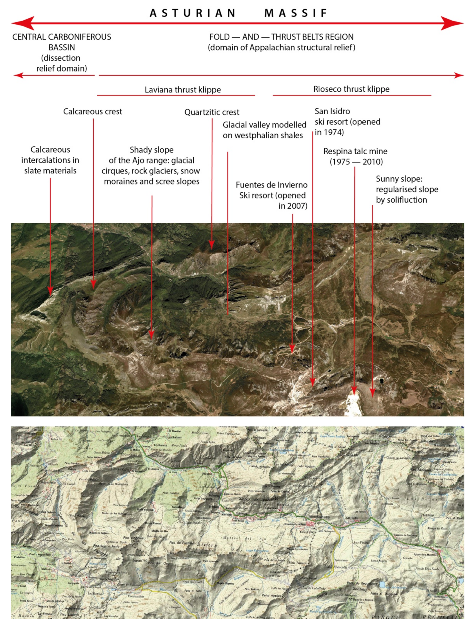
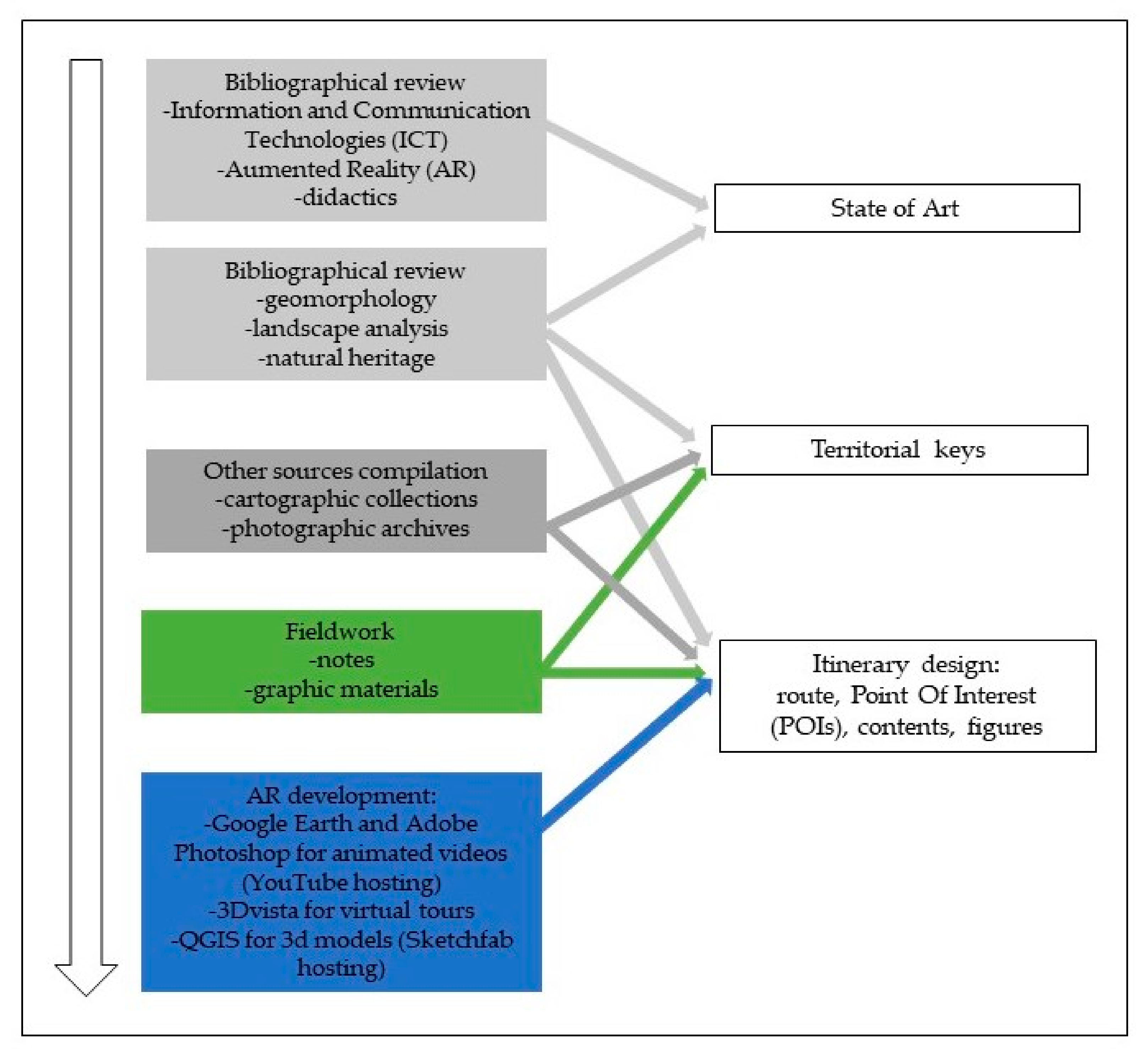
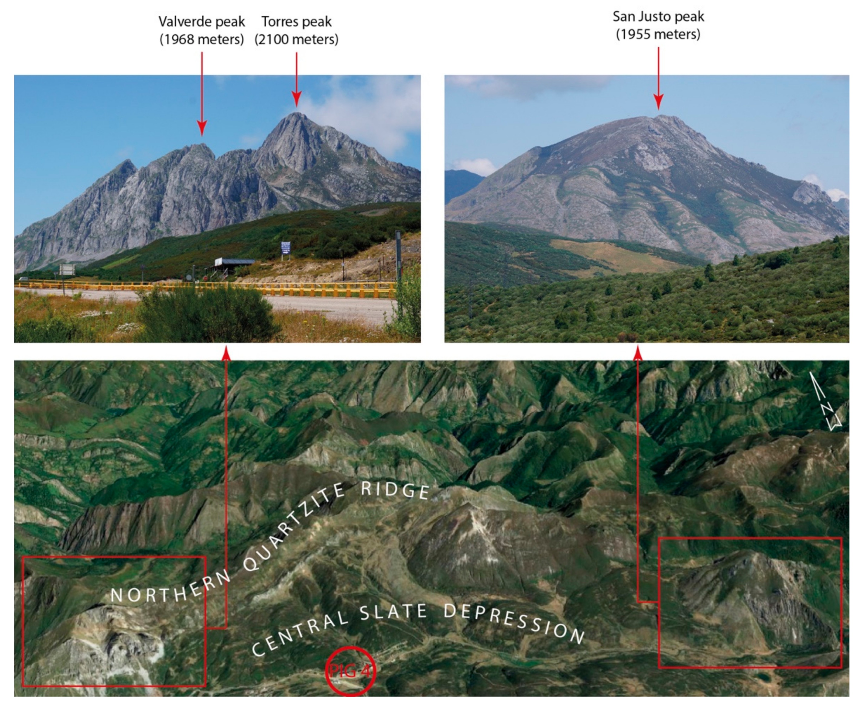