1. Introduction
The definition of geosite has evolved a great deal over the last following two decades: from the original Wimbledon [
1] definition, which generically includes any locality, area, or territory in which a geological or geomorphological interest for conservation can be identified, up to the introduction of concepts such as scientific education, tourism/recreation, and geological heritage value [
2]. A more rigorous approach [
3] provided the distinction between geosite
sensu stricto, defined as in situ elements with high scientific value, and geodiversity sites, displaying significance for education, tourism or cultural identity of communities. Moreover, the “subject” of the site of interest evolved as follows: starting with the simple “geological or geomorphological site”, more and more specific suffix terms (e.g., hydrological, pedological, mineralogical, paleontological, glacial, paleogeographical) were used to classify a geosite.
If we consider the etymological meaning of geosite (from Greek: geo-, earth, the Earth, and from the Latin: situs, a place, position), however, it literally means a site of special geological interest, including all the facets of the Earth Sciences disciplines. Following this more general definition, we believe that each site of geological interest can provide information, if adequately presented and emphasized, on the past evolution of the territory, thus improving the recognition of the geological heritage (geoheritage) and the popularization of the endogenous and exogenous processes that control the evolution of our Earth.
The tool to evaluate the role of a specific geosite in the fields of research, teaching, scientific tourism and the protection of the environmental, landscape and geodiversity heritage is the geosites inventory [
3,
4,
5]. Moreover, the inventory is also a useful tool to assess the geosites on quantitative and qualitative levels as follows: by using different scales of value and numerical evaluation, it becomes a crucial key for territorial planning. The inventory guidelines establish the completion for each geosite card of a descriptive part, which can become the starting point for the preparation of material necessary for the geological dissemination. The description and interpretation of a geosite become even more important in territories labelled as UNESCO Global Geoparks, where it is mandatory to spread geological information to non-geologists, approaching both local communities and a wider audience of visitors (
https://en.unesco.org/global-geoparks/focus (accessed on 17 June 2022).
As a rule, geosites inventories are characterized by the prevalence of geosites explaining the link between geomorphological processes and landforms deriving from the landscape (i.e., geomorphosites; [
6,
7,
8]). This type of geosites is easily understood by observers with different educational levels and requires intuitive and simple informative panels. However, it is not so easy to popularize complex endogenic geological processes. For this reason, the geosites dealing with structural geology (structural geosites) are surveyed less frequently [
4,
9,
10,
11,
12,
13]. Conceiving their interpretative panels requires a deep knowledge of the processes that control and guide the forces acting deep on the Earth and a significant effort to use basic-level scientific terms without falling into misunderstandings and careless and inaccurate descriptions.
Geological structures, such as faults and folds, however, may strongly control and model the morphology of territory and/or trigger the exogenous processes responsible for a specific landform/landscape. The role played by structural geology is even more evident in an area such as the Apuan Alps (Northern Apennines, Italy), which displays many of the geological structures related to rock deformation typical of different crustal levels. Indeed, the Apuan Alps have been considered a natural laboratory for Italian and foreign structural geologists since the end of the XIX century, as witnessed by hundreds of scientific papers about this topic. The Apuan Alps UNESCO Global Geopark promoted this geological exposé by establishing in 2015 a set of new structural geosites that have gone to merge into its geosites inventory, which is constantly being updated and now counts a total of 256 geosites. However, only a few of the geosites have explanatory panels.
The aim of this contribution is to further increase the number of structural geosites and interpretative panels for disclosing structural geology in the Apuan Alps UGGp. We present three structural geosites (two already inserted in the Apuan Alps UGGp geosites inventory, and one new entry) and the three new interpretative panels available for excursionists and scholars. Each interpretative panel is characterized by informative texts and drawings that interpret and explain the geological structures in simple, non-technical, but scientifically correct, terms. This approach is the result of the collaborations between the Apuan Alps UGGp, the Institute of Geosciences and Earth Resources—National Research Council of Italy (IGG-CNR), and the Department of Earth Sciences of the University of Pisa.
2. The Structural Geology in the Apuan Alps
2.1. A Short Historical Review
Due to the excellent rocky exposures and the relevant economic value of marble extraction, the Apuan Alps have attracted generations of both Italian and foreign geologists. Leaving aside the former unpublished observations, the first manuscripts containing geological descriptions are those by Targioni Tozzetti [
14] and Savi [
15]. In the Apuan Alps, detailed field mapping led to the remarkable production of geological maps on topographic bases, which represent one of the first worldwide examples of modern geological cartography (e.g. [
16,
17,
18]).
The geological research on the tectonic interpretation of a mountain orogenic belt (i.e., structural geology investigations) has experienced in the Apuan Alps the whole scientific path from the autochthonous theories to the allochtonous reconstructions up to the models consistent with plate tectonics. While the above-mentioned papers reflect the autochthonous theories, the interpretation of the Apuan Alps as resulting from nappe tectonics was proposed for the first time by Steinmann [
19]. Steinmann’s theory, suggesting the tectonic duplication of the continental margin succession (Tuscan units), was supported by Lencewicz [
20] and Tilmann [
21], and the Apuan Alps were recognized for the first time as a tectonic window. These authors proposed a nappe pile including the following three superimposed tectonic units divided by main overthrusts (from bottom to top): (1) Toscanide I, consisting of metamorphic rocks cropping out in the tectonic window; (2) Toscanide II, non-metamorphic (currently named Tuscan Nappe), from the Calcare Cavernoso formation to the Macigno formation; (3) non-metamorphic Ligurian Units.
Following the main papers by Trevisan [
22], Ippolito [
23] and Merla [
24], the scientific community definitively accepted the allochtonous theories. During the 1970s and 1980s, research on the geological evolution of the area was inserted within the crustal plate movements of the western Mediterranean area. The new methods of structural analysis led to the identification of a complex polyphase deformation history affecting the metamorphic Tuscan units as well as the Tuscan Nappe and the Ligurian Units (e.g. [
25,
26,
27,
28,
29]).
Therefore, the Apuan Alps can be considered an open-air gym for the study of all the main features of its structural geology, such as relationships between foliations and lineations, superposed structures (folds and faults) and the interaction between deformation and metamorphism at different structural levels. The currently accepted architecture and the evolutive model, elaborated thanks to modern structural geology techniques since the end of the 1970s, are described in the section below.
2.2. The Present Day Model
The present-day architecture of the Northern Apennines (
Figure 1) resulted from the convergence-related processes that started with the Upper Cretaceous intraoceanic subduction in the Ligure-Piemontese oceanic basin and continued through the middle Eocene continental collision between the two continental margins, namely, the Europa plate and the Adria microplate. The architecture of the Northern Apennines was restored in the Apuan Alps region as follows: the oceanic-derived units (Ligurian Units) represent the uppermost portion of the nappe stack above the non-metamorphic Tuscan unit (Tuscan Nappe), whereas the Tuscan Metamorphic Units (Apuan Alps Unit and Massa Unit), exposed in the Apuan Alps tectonic window, represent the deepest root of the belt (
Figure 1). These units derived from the oceanic and Adriatic continental domains (e.g., Ligurian Units and Tuscan units, respectively) were stacked towards the NE.
The tectonic evolution model includes two main progressive deformation phases [
30] (
Figure 2). The first phase D1 produced the tectonic nappe stack; it was associated with the development of a pervasive foliation. This main foliation corresponds to the axial plane of non-cylindrical, E-facing, isoclinal folds observable from micro- to kilometer-scale; the related stretching lineation shows a regional NE-SW orientation. During this phase, dated late Oligocene-early Miocene [
31], the units recorded the metamorphic peak at T ≈ 350–450 °C and P ≈ 0.6 GPa ([
32] and references therein).
In the early stages of the second deformation phase D2 (phase D2a in
Figure 2), large-scale non-cylindrical folds associated with sub-horizontal crenulation axial planar foliation refolded D1 structures. It produced the progressive exhumation of the antiformal stack starting before 11 Ma at a temperature T > 250 °C [
31,
33,
34] through the activation of low-angle shear zones (e.g. [
35]). The exhumation processes are generally considered to have developed under an extensional regime. Alternatively, Molli and Vaselli [
36] suggested a syncontractional context triggering the exhumation of the Tuscan Metamorphic Units. Analogously, Carosi et al. [
37] proposed that the exhumation of the Tuscan Nappe was generated by the interference between two main directions of horizontal shortening of later folding phases, which induced buckling and vertical growth of the metamorphic dome.
Finally, semi-brittle to brittle tectonics characterized the D2 latest stages (phase D2b in
Figure 2) within an extensional tectonic regime, leading to the activation of high-angle faults [
35,
38,
39]. These structures strongly influence the landscape, which shows landforms typical of tectonically active regions with high rates of uplift, producing high relief topography prone to higher erosion rates along steep mountain slopes. Overall, the landscape of the Apuan Alps is characterized by great tectonic control of the landforms due to both the primary formation of the metamorphic dome inside the tectonic window and the latest fault systems.
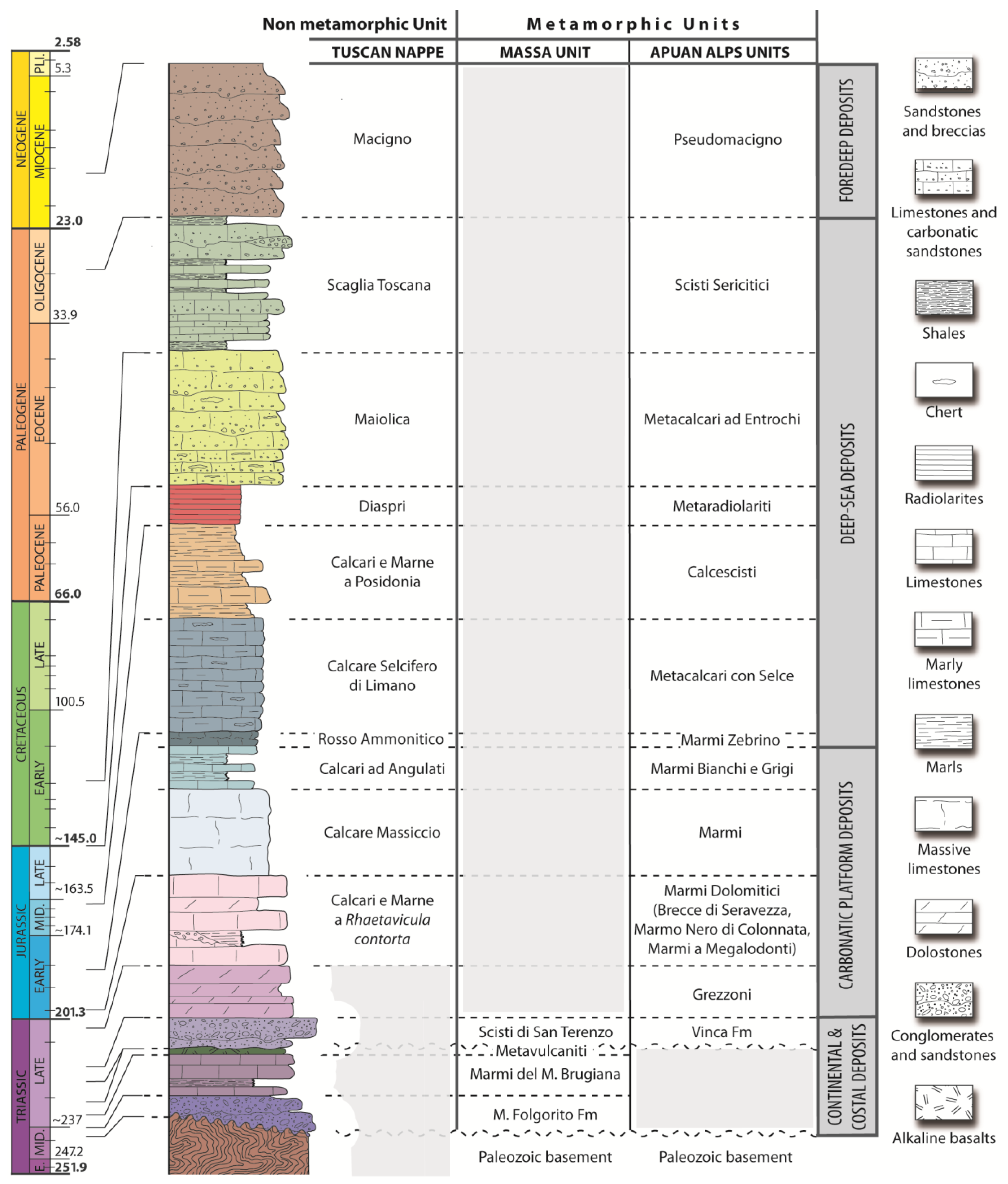
3. The Stratigraphy of Tuscan Domain
The stratigraphic succession of the Tuscan units (Tuscan Nappe and Tuscan Metamorphic Units) reflects the evolution of a typical passive continental margin that was progressively involved in a collisional setting. The sequence typical of the Adria passive margin is shown in
Figure 3.
The sequence commenced during the Late Triassic/Early Jurassic with carbonate platform deposits followed by deposits recording the progressive drowning of the platform (limestones and marly nodular limestones; Early Jurassic). Calcareous turbiditic and pelagic deposits (Early-Middle Jurassic) covered the drowned platform. The Late Jurassic deposits are represented by radiolarian cherts, in turn, covered by lower Cretaceous turbidites, sourced by fragmentation and erosion of the carbonate platform, and by a complex formation composed of shales, marls, calcilutites and calcarenites (Late Cretaceous—early Oligocene). The top of the stratigraphic succession is composed of Oligocene—lower Miocene turbiditic sandstones representing the infilling of the foredeep basin located at the front of the Apenninic accretionary prism. Due to the varied paleogeography of the Adria passive margin, the thickness of each formation is highly variable, displaying a high sedimentation rate in subsiding basins and a low sedimentation rate on structural highs.
As above described, the deformation evolution of the Apuan Alps led to the tectonic duplication of the Tuscan domain sequence, so that the formations of the non-metamorphic Tuscan Nappe have their counterparts in the metamorphic rock units belonging to the metamorphic Tuscan units. Consequently, sedimentary and metamorphic formations are named differently according to their affinity (
Figure 3). The following differences exist if we consider the pre-Rhaetian age: the Tuscan Nappe was detached from its basement in correspondence with the Rhaetian evaporites and dolostones, whereas the Tuscan metamorphic units preserve Palaeozoic rocks and lower middle Triassic siliciclastic rocks deposited on the continental environment on the Adria margin before its drowning (
Figure 3).
4. Materials and Methods
The experiences gained during several years of activity in the field of structural geology and in the dissemination in the specific area of the Apuan Alps (e.g. [
35,
37,
42,
43,
44,
45,
46,
47]) allowed us to conceptualize and design three new interpretative panels for two geosites already included in the Apuan Alps UGGp geosites inventory (i.e., the Apuan Alps tectonic window and the Mt. Forato Arch) and for a new geosite (i.e., the folds of Bosa) that we have recently chosen and interpreted (
Figure 1). They were selected considering their geological interest (in the widest possible meaning), their particular and significant manifestation of geodiversity and their safety accessibility. Furthermore, it should be noted that the selection of these geosites has also taken into account their degradation risk [
48], estimated as very low, and their state of conservation, estimated as good. This approach is aimed at respecting the principles and practice of geosite conservation to ensure that they remain accessible and usable by a wide audience. Particularly, the accessibility and the interpretative potential of geosites are key features for setting up eco-compatible fruition programs and approaching a wide audience disseminating geological information to non-geologists.
In each interpretative panel (see
Supplementary material), we used highly readable short text (both in Italian and in English) with few essential concepts. We inserted simple drawings to explain the few basic specialist terms used in the description. The text is calibrated to a base level of knowledge of geology (i.e., high school level). For example, the reader must know the difference between metamorphic and sedimentary rocks as well as the definition of fault. To popularize the scientific terminology, however, we inserted in each panel a QR code linked to a glossary of the used terms. We have chosen to minimize the environmental impact of the panels by choosing soft and light colors.
The object of our scientific/educational research is represented by three structures produced at different deformation regimes and structural depths during the evolution of the Apuan Alps. They are structures with different scales of observation ranging from landscape view (Apuan Alps tectonic window and the Mt. Forato Arch), controlling the morphology, vegetation distribution and landforms, to the outcrop scale (the fold of Bosa). The Apuan Alps tectonic window geosite is a complex fault zone that acted at different crustal scales (from ductile-brittle to brittle deformation regime) and with opposite kinematics during the evolution of the Apuan Alps dome. It separates the metamorphic and the non-metamorphic rocks (
Section 5.1) (
Figure 1,
Figure 4 and
Figure 5). The Mt. Forato Arch geosite (
Section 5.2) (
Figure 1 and
Figure 6) was controlled by the presence of two systems of conjugate fractures in the metamorphic carbonate rocks of the Apuan Alps units developed in the uppermost crustal levels during the extensional regime responsible for the exhumation of the Apuan Alps dome, whereas the folds of Bosa geosite (
Section 5.3) (
Figure 1 and
Figure 7) show beautiful fold structures produced by frictional regime in the non-metamorphic formation of the Tuscan Nappe (i.e., Scaglia Toscana formation).
5. Results
The results of our work are the interpretative panels that were recently placed in the locations shown in
Figure 1. The panel of the Apuan Alps tectonic window geosite (number 1 in
Figure 1) is in correspondence with a beautiful outcrop along a roadcut 1 km south of Maestà della Formica Pass (Careggine Municipality) (
Figure 4,
Figure 5,
Figure 8 and
Figure S1), whereas the panel of the suggestive Mt. Forato Arch (number 2 in
Figure 1,
Figure 6,
Figure 8 and
Figure S2) is found at the parking lot close to the “Palazzo della Cultura” in Cardoso (Stazzema Municipality), rebuilt after the flooding event that destroyed the village [
49]. The panel is in Cardoso because, from there, it is possible to admire the arch of Mt. Forato in the far landscape and reach the Mt. Forato Arch through one of the most popular paths of the Italian Alpine Club (CAI) in the Apuan Alps. The interpretative panel for the folds of Bosa (number 3 in
Figure 1) is in the cellar of the Apuan Alps UGGp farm in Careggine. This geosite has been “created” during the excavation of the foundations and its accessibility is guaranteed by a suggestive window that was appositely left open in the exterior wall (
Figure 7,
Figure 8 and
Figure S3).
5.1. The Apuan Alps Tectonic Window Geosite
In the Apuan Alps, the metamorphic rocks of the deepest tectonic unit (the Tuscan metamorphic units) are exposed to an area of over 200 km
2 thanks to the erosion of the sedimentary rocks belonging to the overlying Ligurian Units and the Tuscan Nappe (
Figure 1 and
Figure 4). The tectonic window, or in other words, the distribution of metamorphic rocks, is also highlighted by a change in the morphology and vegetation as follows: the Alpine-type morphology peaks with scarce and brushy vegetation characterize the Tuscan metamorphic units, whereas the woody surrounding smooth and smaller elevation mountains are made by the non-metamorphosed Tuscan unit (i.e., Tuscan Nappe) (
Figure 4a). In recognition of its acknowledgment at a global level [
50], the Apuan Alps tectonic window was listed as the geosite n. 1 in the geosites inventory of the Apuan Alps UGGp [
42].
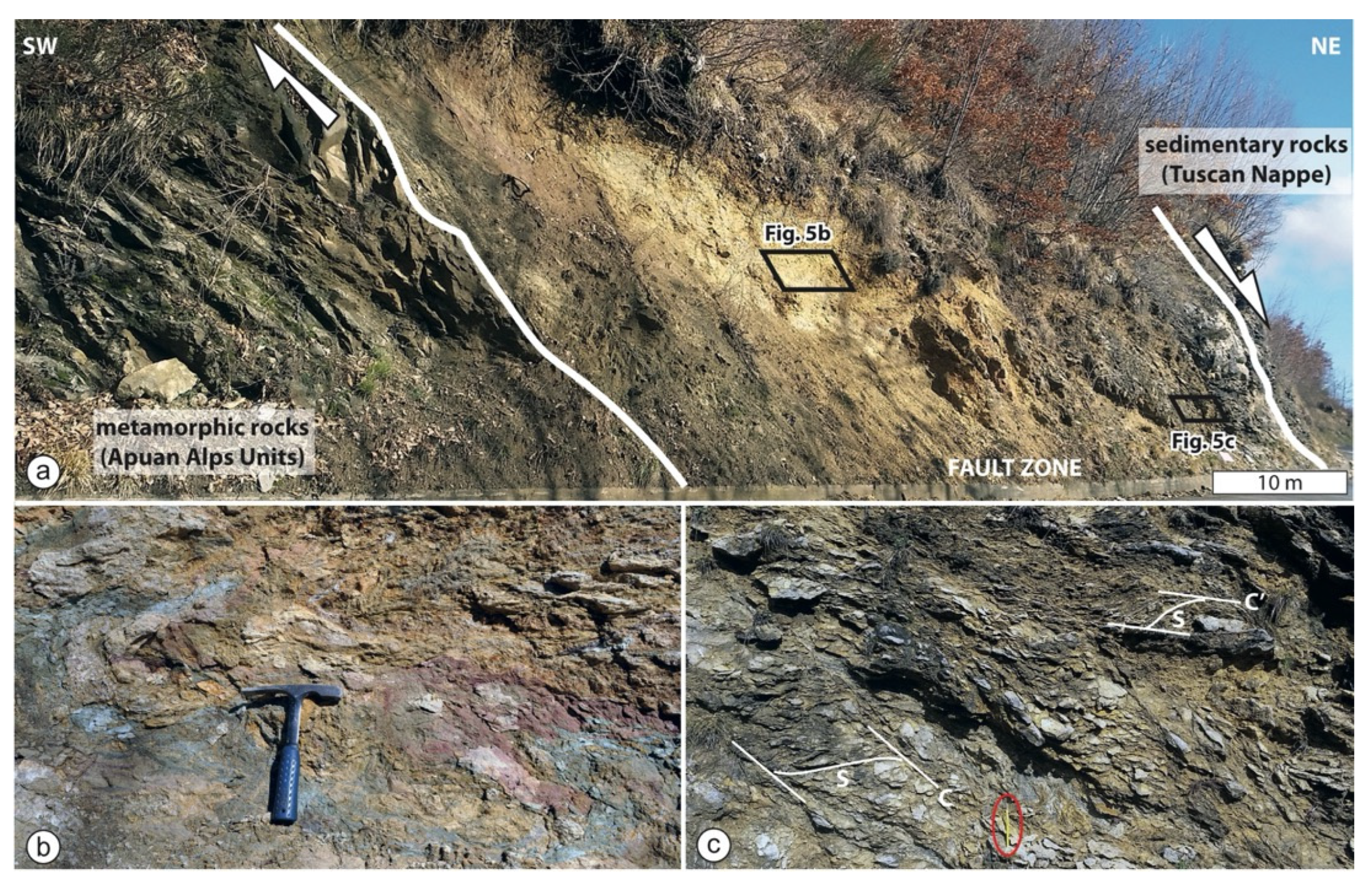
Along the road cut (
Figure 5a), we can observe the main contact of the Apuan Alps tectonic window gently dipping towards the northeast. It is characterized by a fault zone showing a thickness of several 10s of meters that separates the metamorphic rocks of the deepest Apuan Alps units, on the left, and the Tuscan Nappe sedimentary rocks, on the right [
35,
51]. The metamorphic rocks are derived from sandstones and shales of the Oligocene-Miocene age (about 25–20 million years ago) (i.e., the Pseudomacigno formation), whereas the sedimentary rocks are limestones of the Early Jurassic age (about 200 million years ago) (i.e., the Calcari ad Angulati formation).
Since 27–20 Ma (K-Ar and Ar-Ar isotopic age) [
31], this tectonic contact acted as a reverse fault in a compressional tectonic regime, producing the doubling of the Tuscan domain sequence with the superimposing of the sedimentary unit (Tuscan Nappe) onto the Tuscan metamorphic units (D1 phase;
Figure 2). From late Miocene (11—8 Ma) [
31] to c. 2 Ma ([
52] with reference therein) its kinematics changed and it became a low-angle normal fault (early D2b phase), allowing the exhumation and uplift of the Apuan Alps (
Figure 2). The activity of the tectonic contact during the extensional tectonic regime put the youngest formation of the Apuan Alps units (i.e., Pseudomacigno formation) in contact not to the base of the Tuscan Nappe (i.e., Calcari e Marne a
Rhaetavicula contorta formation) but to the youngest Calcari ad Angulati formation, with the lack of three formations deposited from the Upper Triassic to Lower Jurassic (i.e., Calcari a Marne a
Rhaetavicula contorta, Calcare Massiccio and Rosso Ammonitico formations) (
Figure 3). This tectonic gap corresponds to a minimum time gap of about 25 million years.
Moving from southwest to northeast along the roadcut where the geosite is located, the metamorphic rocks are initially affected by fractures that progressively increase their number and size. The inner portion of the fault zone (i.e., the fault gouge;
Figure 5b) consists of a fine-grained matrix ranging in color from violet, reddish and ochre due to fluid infiltration. It contains cm-sized clasts of metamorphic rocks deriving from the footwall (i.e., Apuan Alps Units) and sedimentary rocks from the hanging wall (i.e., Tuscan Nappe). Above the fault gouge, there are the foliated cataclasites of the sedimentary rocks of the Tuscan Nappe (
Figure 5c) with S-C-C’ fabrics showing a top to the E kinematics. The fault zone is then affected by high-angle normal faults that have developed in a more recent time (late D2b phase;
Figure 2).
5.2. Mt. Forato Arch Geosite
The peculiarity of Mt. Forato is the presence of a natural rock arch determined by an opening, a “hole”, forming a large, virtually round window through the rocks (
Figure 6). The arch of Mt. Forato is one of the largest Italian natural arches, displaying a “window” of 32 m in width and 26 m in height, while the dimensions of the rocks above the hole range from 8 to 12 m in both width and thickness. The northern and southern main peaks that delimit the rock arch reach a height of 1.208 m and 1.230 m a.s.l., respectively. Mt. Forato forms the main watershed of the central-southern Apuan Alps (
Figure 1) and is therefore visible both from the Versilia maritime side, on the west (where the interpretative panel is located) (
Figure 6a) and from the Garfagnana/Serchio valley area, on the east. The Mt. Forato “window” affords fine views of the Ligurian sea and, during particularly clear days, the Corsica mountains (
Figure 6b).
The Mt. Forato Arch was formed mainly in marbles and dolomitic marbles (i.e., Marmi and Marmi Dolomitici formations) of the Apuan Alps Units (
Figure 3). The hole has been created in geological times by the selective removal of rock portions. The formation of the arch started from the development of two main conjugated fracture systems (
Figure 6c,d) activated at shallower structural levels during the late D2b phase (
Figure 2). The intersection between these two systems of fractures and their progressive widening led to the isolation of portions/blocks in marbles and dolomites that, under the action of gravity, collapsed by opening the window in the rock face. The widening and the progressive deepening of the fractures are mainly controlled by the runoff and infiltration of rainwater that produces the chemical dissolution of the carbonate rocks. The action of the temperature variation in summer (thermoclastic: alternate heating/cooling) and the changing state of water in winter (cryoclastism: alternate freeze/thaw) emphasize these rock-breaking mechanisms. The weathering processes interacting with the carbonate/dolomite rock wall contributed to the current result.
A key point to understand, even for those who are only interested in a basic comprehension of natural arches, is that wind is not a significant factor in their formation. The wind has no more than a smoothing effect on the rocks after the natural arch has formed.
Apart from those natural rock arches whose formation was directly observed and recorded in historical archives, the age of natural arches, such as the Mt. Forato Arch, cannot generally be determined. However, it is possible to argue that these geological landforms are recent features in the geological time scale and that, due to their characteristics, they have a noticeably short life on the same time scale. We can estimate that the formation of the Mt. Forato Arch could have started about 10.000 years ago when the rocks of the Apuan Alps were exposed after the melting of the glaciers of the Last Glacial Maximum [
53].
Mt. Forato is an iconic mountain, perhaps the main symbol of the Apuan Alps. It is certainly the most photographed geosite. The fact that, during the summer solstice, depending on the point of view, the sunrise can be observed through the rock arch from the Tyrrhenian coast, whereas the “double” sunset is visible from the Garfagnana/Serchio valley area, has contributed to the increase in fascination towards this “magic” mountain and many legends and folk tales have multiplied around its landform. In Garfagnana, a legend tells that the “hole” was formed by the impact of the Devil beaten on the rock wall by a slap of San Pellegrino, annoyed by the Devil himself. In Versilia, instead, another legend tells that the Mt. Forato rock arch was created as a miraculous passage to allow the Holy Family to cross the Apuan Alps fleeing from Herod’s soldiers after their exodus to Egypt.
The importance of Mt. Forato is also artistic. Its silhouette has indeed inspired artists through time. Probably the brightest example is the painting dated 1871 by the Italian-Hungarian landscape painter Andrea Markò (1824–1895), which is exhibited at the Gallery of Modern Art in Florence. It is a perfect example of how Geopark can embrace a holistic approach, celebrating its cultural and natural heritage and providing a narrative for the territory.
5.3. The Folds of Bosa Geosite
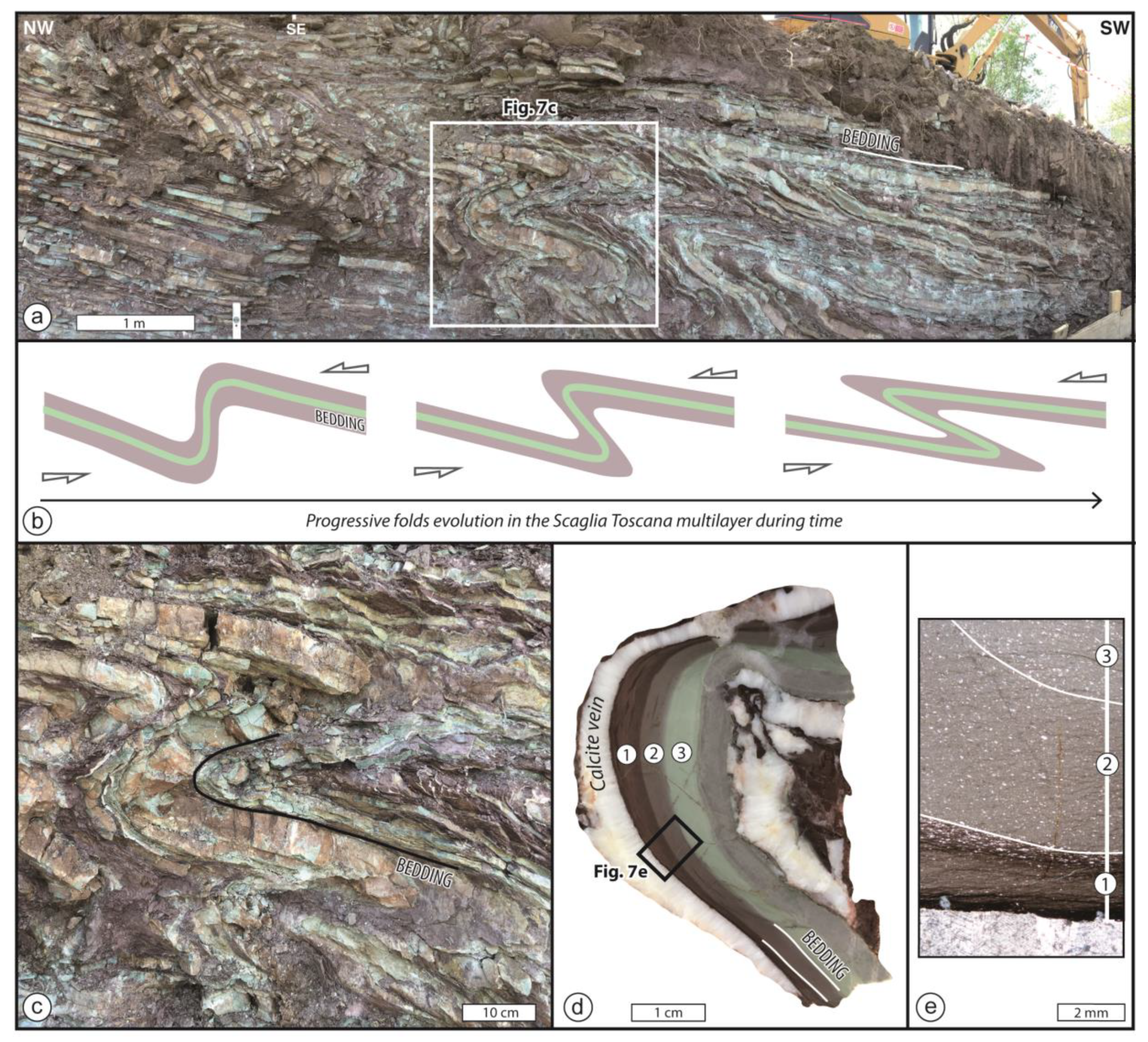
The rocks exposed during the work for the construction of the new cellar of the Apuan Alps UGGp farm in Bosa (Careggine, Lucca) are sedimentary rocks belonging to the Scaglia Toscana formation of the Tuscan Nappe (
Figure 3). They are alternating 5 mm to 5 cm thick levels of distinct colors and composition, which stand out the red and green that draw stunning forms called folds (
Figure 7a). The distinctive feature of this outcrop is the high concentration, lateral continuity, and beautiful preservation of folds, which are found rarely in the Tuscan Nappe exposed on the eastern side of the Apuan Alps.
The multicolored layers are the result of the progressive accumulation of sediments in a deep marine environment where reddish beds of clay alternate with (grey) green beds of calcilutite. The period during which the sediments that constitute these rocks were deposited has not been determined with certainty. By analogy with rocks from other areas belonging to the same geological formation, they can be assigned to the Eocene epoch (about 40 million years ago).
The development of folds is the result of a progressive deformation (
Figure 7b), in which the thickness of carbonate layers remains constant along the layer whereas that of the clay layers increases in the zone of maximum curvature of the layer (i.e., the hinge zone of the fold) (
Figure 7c,d). The presence of calcite veins developed parallel to the bedding surface (
Figure 7d) and the presence of striae orthogonal to the line that contains all the points of maximum curvature on the same bedding surface (i.e., the axis of the fold) indicate that the main folding mechanism is buckling. This implies that the compressive forces responsible for the buckling acted parallel or at a low angle with respect to the bedding. In addition, the asymmetric profiles of folds may suggest that a component of simple shear was present during the folding.
From microscopic observations on thin sections obtained from samples representative of the fold hinge zone (
Figure 7e), it is concluded that the bedding was the only surface folded. The different compositional layers (1, 2 and 3 in
Figure 7d,e) differ in the content of calcite and clay. In the carbonate-rich layers, (2 and 3 in
Figure 7e), the roughly elongated white portion of less than 100 µm in size might be both clasts derived from older rocks and relicts of foraminifera. Each layer is characterized by thin (<100 µm), laterally discontinuous, and wriggly films of dark insoluble minerals resulting from the dissolution of calcite (i.e., mechanisms of pressure solution).
This deformation mechanism and the lack of metamorphic blastesis indicate that the folds of Bosa were generated in the shallower 10–15 km of the Earth’s crust. How is it possible to fold rocks in the uppermost 10–15 km of the crust where the temperature is lower than 400 °C (assuming a Barrovian geothermal gradient)? Common practical sense would indicate that in these conditions, rocks break (generating faults and related earthquakes) because they are cold, strong and rigid. The folding of a rock is a difficult concept to explain because it implies the concepts of geological time and strain rate. In the shallower Earth’s crust, in fact, folding a volume of rocks implies extremely weak forces acting for millions of years.
In the case of the folds of Bosa, these forces originated during the Apenninic orogenesis. Linking their genesis to a specific deformation phase that occurred during the evolution of the Apuan Alps (see
Section 2.2) is not easy. Considering that they developed at very shallow depths (as suggested by the lack of evident metamorphic blastesis and by a mechanism of pressure solution), we roughly constrain their evolution during the early D2 phase (
Figure 2).
6. Discussion
The areal distribution of different rocks on the Earth’s surface reflects the geometries produced by stresses acted at depth on the Earth for millions of years. For this reason, endogenous processes represent the primary trigger for controlling the morphology of the landscape, on which exogenous processes act selectively by producing many of the current geosites. The difficulty of describing processes not active on the Earth’s surface that occurred during geological time makes it challenging to interpret the resulting structures and, consequently, to popularize geosites dealing with structural geology. To be able to individuate a possible structural geosite and conceived its interpretative panel requires good knowledge of the processes that act inside the Earth and the resulting geometries and kinematics. In this contribution, we popularized three structural geosites representative of the Apuan Alps, which we have developed into educational panels at each geosite. The selected geosites have great scientific and landscape value. The Apuan Alps tectonic window, in fact, has been the object of hundreds of scientific publications since the beginning of the 20th century. The metamorphic rocks exposed in the window are the deeper roots of the Apenninic orogenic belt and so represent a perfect open-air laboratory to study the processes acting in the depths of the Earth’s crust. The Mt. Forato Arch also has cultural importance, as an icon of the Apuan Alps, which directly controls the geomorphological aspects. Finally, the folds of Bosa are a rare example of plicative deformation in sedimentary rocks, which is found only rarely in the Tuscan Nappe exposed on the eastern side of the Apuan Alps. To be poetic, we can say that the three selected geosites are windows: a tectonic window, a window in the landscape and a window in a wall, respectively.
The goal of our work is to involve and interest a broad audience, ranging from students to the lay public interested in geological features that find themselves exploring the Apuan Alps UGGp. The methods adopted in this paper derive from the correct scientific interpretation of the geosites and the use of simple language and many graphic schemes that facilitate the understanding of the structures that form the geoheritage of the Geopark area. The in-situ panels make available the geological information without time limitations, for direct fruition, which has positive implications for geo-education and geotourism. The free and independent consultation of the outdoor panels allows safe fruition of the geological heritage during tough times, such as the recent COVID-19 pandemic, when gatherings of people were prohibited or not recommended.
The geosite information of the interpretative panels can be integrated with further resources easily available by scanning the QR codes included. Using classical (the panels) and interactive (the QR codes) approaches, we want to gather a wide audience with quite different needs and informatic skills. Acceding to additional electronic information, the panel becomes an interactive tool. Using camera-equipped mobile devices and free QR code reader apps, in fact, users have access to a large amount of information about the Apuan Alps UGGp. We decided to insert three different QR codes. The first is a dynamic QR code, which directs the visitors to the geological pages of the Apuan Alps UGGp that provide readers with additional information about the geological evolution of the Apuan Alps, the list of all geosites of the Apuan Alps UGGp and receives the other scientific and tourist information contained in the Geopark website (
http://www.apuanegeopark.it/english_version/apuanegeopark_geology.html (accessed on 17 June 2022). Even if the text of the panels is planned considering the geological knowledge acquired in the high schools, we would like scientific/specific geological terminology to become part of the common language. For this reason, the second QR code links to a geological multilingual glossary (Italian and English) with all “non common” terms used in the interpretative panel.
- -
Did direct observation of this outcrop (geosite) and its interpretative panel allow you to focus on previously unknown geological aspects?
- -
Are the explanations of the panel clear enough and have they answered the questions you asked yourself?
- -
After reading the panel, did any other questions about geological definition and processes arise that you would like to have answered?
- -
What questions arose and would you like further explanation?
- -
What is your degree of satisfaction with the content of the panel? In the light of quality of graphics representation, picture interpretation, text clarity and position of the panel.
We believe that this is also an opportunity to gather information about the Apuan Alps UGGp visitors, so we inserted questions about the nationality and age of readers. The results will provide interesting feedback for better management of the Geopark. For example, we can have information about the visibility of the Geopark within the territory and raise awareness around the UNESCO Global Geopark label. Moreover, the feedback can verify if the panels effectively convey information about the geosites or how they could be improved for a better spread of knowledge about the geological heritage of the Geopark.
7. Conclusions
Differently to geological processes that modify and control the landscape instantaneously or in a short and easily recorded time (e.g., earthquakes, landslides, or volcanic eruptions), the processes that take place within the Earth (endogenous processes) in very long times (not comparable with human time) are not easily understood by those not familiar with the concept of geological time. These processes, however, have a great impact on landform/landscape, vegetation distribution as well as on society (e.g., the distribution of different lithotypes controlling the distribution of water, raw materials, the location of potential landslides, etc.). The goal of structural geology is to describe and interpret the structures produced by endogenous processes that have acted for millions of years within the Earth. Popularizing structural geology requires a great effort because millions of year-long processes must be translated into simple concepts. It is for this reason that in an orogenic belt such as that exposed in the Apuan Alps UGGp, which shows tectonic structures of great scientific and landscape value, an act of interpretation and dissemination of structural geosites was undertaken.
The collaboration between the Apuan Alps UGGp and research institutions has resulted in the production of three new interpretative panels related to structural geosites. The structural geosites can be considered suitable for raising awareness of the public about the need to foster, safeguard, protect and popularize the geoheritage of the Apuan Alps as a unique area. Geotourism can benefit from our on-site interpretation panels because three of the many possible geostops during excursions in the Apuan Alps are explained in the panels that illustrate exemplary geosites for geological structures. UNESCO Global Geoparks consider geotourism and Earth Sciences communication as two central topics in their management. Many efforts are focused on finding the best effective transmission of geological knowledge and geoheritage values to a wide range of audiences, from school children to adults and between local people and visitors, so that they themselves can become the Ambassadors of these territories.
Supplementary Materials
The following supporting information can be downloaded at:
https://www.mdpi.com/article/10.3390/land11081282/s1, Figure S1: Interpretative panel of the Apuan Alps tectonic windows geosite; Figure S2: Interpretative panel of the Mt Forato Arch geosite; Figure S3: Interpretative panel of the Folds of Bosa geosite.
Author Contributions
Conceptualization, C.F. and G.O.; methodology, A.A., A.B., C.F. and G.O.; investigation, A.A., A.B., C.F. and G.O.; writing—original draft preparation, C.F. and G.O.; writing—review and editing, A.A., A.B., C.F. and G.O.; illustrations, A.B., C.F. and G.O.; graphic design, C.F.; Project Administration, A.A., A.B. and G.O.; funding acquisition, A.A., A.B. and G.O. All authors have read and agreed to the published version of the manuscript.
Funding
This research was funded by Ente Parco Regionale delle Alpi Apuane-Apuan Alps UGGp, and by CNR-IGG, Pisa (project manager G. Ottria).
Institutional Review Board Statement
Not applicable.
Informed Consent Statement
Not applicable.
Data Availability Statement
The data that support the findings of this study are available from the corresponding author upon reasonable request.
Acknowledgments
The authors are grateful to Charalampos Fassoulas and three anonymous reviewers for their constructive criticism.
Conflicts of Interest
The authors declare no conflict of interest.
References
- Wimbledon, W.A.P. Geosites: A new conservation initiative. Episodes 1996, 19, 87–88. [Google Scholar] [CrossRef]
- Ruban, D.A.; Kuo, I.-L. Essentials of geological heritage site (geosite) management: A conceptual assessment of interests and conflicts. Nat. Nascosta 2010, 41, 16–31. [Google Scholar]
- Brilha, J. Inventory and Quantitative Assessment of Geosites and Geodiversity Sites: A Review. Geoheritage 2016, 8, 119–134. [Google Scholar] [CrossRef]
- Fuertes-Gutiérrez, I.; Fernández-Martínez, E. Geosites Inventory in the Leon province (Northwestern Spain): A tool to introduce Geoheritage into Regional Environmental Management. Geoheritage 2010, 2, 57–75. [Google Scholar] [CrossRef]
- Fassoulas, C.; Mouriki, D.; Dimitriou-Nikolakis, P.; Iliopoulos, G. Quantitative assessment of geotopes as an effective tool for geoheritage management. Geoheritage 2012, 4, 177–193. [Google Scholar] [CrossRef]
- Panizza, M. Geomorphosites: Concepts, methods and examples of geomorphological survey. Chin. Sc. Bull. 2001, 46, 4–6. [Google Scholar] [CrossRef]
- Reynard, E.; Panizza, M. Geomorphosites: Definition, assessment and mapping. Géomorphologie Relief Process. Environ. 2005, 11, 177–180. [Google Scholar] [CrossRef]
- Reynard, E.; Perret, A.; Bussard, J.; Grangier, L.; Martin, S. Integrated approach for the inventory and management of geomorphological heritage at the regional scale. Geoheritage 2016, 8, 43–60. [Google Scholar] [CrossRef]
- Bartelletti, A.; Amorfini, A.; Ottria, G. ‘Apuan Alps Geopark’ dossier: Protection and promotion activities for geological heritage. Acta Apuana 2013, XII, 5–67. [Google Scholar]
- De Wever, P.; Alterio, I.; Egoroff, G.; Cornée, A.; Bobrowsky, P.; Collin, G.; Duranthon, F.; Hill, W.; Lalanne, A.; Page, K. Geoheritage, a National Inventory in France. Geoheritage 2015, 7, 205–247. [Google Scholar] [CrossRef]
- Ferrando, A.; Faccini, F.; Poggi, F.; Coratza, P. Geosites Inventory in Liguria Region (Northern Italy): A Tool for Regional Geoconservation and Environmental Management. Sustainability 2021, 13, 2346. [Google Scholar] [CrossRef]
- Valente, E.; Casaburi, A.; Finizio, M.; Papaleo, L.; Sorrentino, A.; Santangelo, N. Defining the Geotourism Potential of the Cilento, Vallo di Diano and Alburni UNESCO Global Geopark (Southern Italy). Geosciences 2021, 11, 466. [Google Scholar] [CrossRef]
- Golfinopoulos, V.; Papadopoulou, P.; Koumoutsou, E.; Zouros, N.; Fassoulas, C.; Zelilidis, A.; Iliopoulos, G. Quantitative Assessment of the Geosites of Chelmos-Vouraikos UNESCO Global Geopark (Greece). Geosciences 2022, 12, 63. [Google Scholar] [CrossRef]
- Targioni Tozzetti, G. Relazioni D’alcuni Viaggi Fatti in diverse Parti Della Toscana; Stamperia Imperiale: Firenze, Italy, 1752; Volume 4, p. 295. [Google Scholar]
- Savi, P. Tagli geologici delle Alpi Apuane e del Monte pisano e cenno sull’isola d’Elba. 1883. Nuovo G. Lett. Sci. 1883, 27, 81–99. [Google Scholar]
- Zaccagna, D. Carta Geologica delle Alpi Apuane Alla Scala 1:25.000; Salomone: Roma, Italy, 1880. [Google Scholar]
- Lotti, B. La doppia piega di Arni e la sezione trasversale delle Alpi Apuane. Boll. Del Reg. Com. Geol. It. 1881, 12, 419–428. [Google Scholar]
- Lotti, B.; Zaccagna, D. Sezioni geologiche nella regione centrale delle Alpi Apuane. Boll. Del Reg. Com. Geol. It. 1881, 12, 5–32. [Google Scholar]
- Steinmann, G. Alpen und Apennin. Mon. Der Dtsch. Geol. Ges. 1907, 59, 177–183. [Google Scholar]
- Lencewicz, S. Profile geologiczne przez Apenin Toskanscki. Rend Soc. Sci. Warszawa 1917, 10, 637–662. [Google Scholar]
- Tilmann, N. Tektonische studien in der catena metallifera Toskanas. Geol. Rundsch. 1926, 17, 631–660. [Google Scholar]
- Trevisan, L. L’Elba orientale e la sua tettonica di scivolamento per gravità. Mem. Ist. Geol. E Min. Univ. Padova 1950, 16, 5–39. [Google Scholar]
- Ippolito, F. Le Alpi Apuane. Mem. Geol. Appl. Univ. Napoli 1950, 3, 49–95. [Google Scholar]
- Merla, G. Geologia dell’Appennino settentrionale. Boll. Soc. Geol. It. 1951, 70, 95–382. [Google Scholar]
- Carmignani, L.; Giglia, G. Le fasi tettoniche terziarie dell’Autoctono delle Alpi Apuane: Studio delle strutture minori della zona centro-meridionale. Boll. Soc. Geol. It. 1975, 94, 1957–1981. [Google Scholar]
- Carmignani, L.; Giglia, G. Il problema della doppia vergenza sulle Alpi Apuane e la struttura del Monte Corchia. Mem. Soc. Geol. It. 1983, 26, 515–525. [Google Scholar]
- Pertusati, P.C.; Plesi, G.; Cerrina Feroni, A. Alcuni esempi di tettonica polifasata della Falda Toscana. Boll. Soc. Geol. It. 1977, 96, 587–603. [Google Scholar]
- Boccaletti, M.; Gosso, G. Analisi della deformazione plicativa e rapporti con lo sviluppo della blastesi metamorfica nell’area di Campo Cecina-M. Pisanino delle Alpi Apuane settentrionali. Mem. Soc. Geol. It. 1980, 21, 101–110. [Google Scholar]
- Kligfield, R.; Carmignani, L.; Owens, W.H. Strain analysis of a Northern Apennine shear zone using deformed marble breccias. J. Struct. Geol. 1981, 3, 421–436. [Google Scholar] [CrossRef]
- Carmignani, L.; Kligfield, R. Crustal extension in the Northern Apennines: The transition from compression to extension in the Alpi Apuane core complex. Tectonics 1990, 9, 1275–1303. [Google Scholar] [CrossRef]
- Kligfield, R.; Hunziker, J.; Dallmeyer, R.D.; Schamel, S. Dating of deformation phases using K/Ar and 40Ar/39Ar techniques: Results from the Northern Apennines. J. Struct. Geol. 1986, 8, 781–798. [Google Scholar] [CrossRef]
- Molli, G.; Giorgetti, G.; Meccheri, M. Tectono-metamorphic evolution of the Alpi Apuane Metamorphic Complex: New data and constraints for geodynamic models. Boll. Soc. Geol. It. Sp. Vol. 2002, 1, 789–800. [Google Scholar]
- Balestrieri, M.L.; Bernet, M.; Brandon, M.T.; Picotti, V.; Reiners, P.; Zattin, M. Pliocene and Pleistocene exhumation and uplift of two key areas of the Northern Apennines. Quat. Internat. 2003, 101–102, 67–73. [Google Scholar] [CrossRef]
- Fellin, M.G.; Reiners, P.W.; Brandon, M.T.; Wuthrich, E.; Balestrieri, M.L.; Molli, G. Thermo-chronologic evidence of exhumational history of the Alpi Apuane metamorphic core complex, northern Apennines, Italy. Tectonics 2007, 26, TC6015. [Google Scholar] [CrossRef]
- Frassi, C.; Ottria, G.; Ferdeghini, A. Fault tectonics of the Tuscan Nappe in the eastern sector of the Apuan Alps (Italy). J. Maps 2020, 16, 745–754. [Google Scholar] [CrossRef]
- Molli, G.; Vaselli, L. Structures, interference patterns, and strain regime during midcrustal deformation in the Alpi Apuane (Northern Apennines, Italy). Geol. Soc. Am. Sp. Pap. 2006, 414, 79–93. [Google Scholar]
- Carosi, R.; Frassi, C.; Montomoli, C.; Pertusati, P.C. Structural evolution of the Tuscan Nappe in the southeastern sector of the Apuan Alps metamorphic dome (Northern Apennines, Italy). Geol. J. 2005, 40, 103–119. [Google Scholar] [CrossRef]
- Ottria, G.; Molli, G. Superimposed brittle structures in the late orogenic extension of the northern Apennine: Results from Carrara area (Alpi Apuane, NW Tuscany). Terra Nova 2000, 12, 1–8. [Google Scholar] [CrossRef]
- Vaselli, L.; Cortecci, G.; Tonarini, S.; Ottria, G.; Mussi, M. Conditions for veining and origin of mineralizing fluids in the Alpi Apuane (NW Tuscany, Italy): Evidence from structural and geochemical analyses on calcite veins hosted in Carrara marbles. J. Struct. Geol. 2012, 44, 76–92. [Google Scholar] [CrossRef]
- Carmignani, L.; Conti, P.; Disperati, L.; Fantozzi, P.L.; Giglia, G.; Meccheri, M. Carta Geologica del Parco delle Alpi Apuane; SELCA: Firenze, Italy, 2000. [Google Scholar]
- Carmignani, L.; Conti, P.; Cornamusini, G.; Meccheri, M. The internal Northern Apennines, the Northern Tyrrhenian Sea and the Sardinia-Corsica Block. In Geology of Italy; Crescenti, U., D’Offizi, S., Merlino, S., Sacchi, L., Eds.; Special Volume of the Italian Geological Society: Roma, Italy, 2004; pp. 59–77. [Google Scholar]
- Amorfini, A.; Isola, I. Primo censimento di geositi meritevoli di tutela e di valorizzazione nelle Alpi Apuane. Acta Apuana 2010, 5, 39–67. [Google Scholar]
- Amorfini, A.; Bartelletti, A.; Ottria, G.; Guazzi, E.; Ravani, S. The Hiking and Geotourist Map of the Apuan Alps: A new tool to get to know the Geopark. Eur. Geoparks Netw. Mag. 2015, 12, 27. [Google Scholar]
- Amorfini, A.; Bartelletti, A.; Ottria, G. Enhancing the Geological Heritage of the Apuan Alps Geopark (Italy). In From Geoheritage to Geoparks; Errami, E., Brocx, M., Semeniuk, V., Eds.; Springer International Publishing: Cham, Switzerland, 2015; pp. 199–214. [Google Scholar]
- Frassi, C.; Ottria, G.; Ferdeghini, A.; Amorfini, A. Geological research and mapping in the Apuan Alps UGGP (Italy). In Proceedings of the 8th International Conference on UNESCO Global Geoparks, Madonna di Campiglio, Italy, 8–14 September 2018. [Google Scholar]
- Ottria, G.; Amorfini, A.; Bartelletti, A.; Giovagnoli, M.C. Updating the geosites inventory of the Apuan Alps Unesco Global Geopark (Italy): Three new structural geosites in metamorphic rocks. In Proceedings of the 14th European Geoparks, Ponta Delgada, Portugal, 7–9 September 2017. [Google Scholar]
- Ottria, G.; Amorfini, A.; Bartelletti, A. New Geotrails Discovering the Apuan Alps UNESCO Global Geopark, Italy. GGN Newsl. 2019, 3, 6–8. [Google Scholar]
- Brocx, M.; Semeniuk, V. The “8Gs”—A blueprint for Geoheritage, Geoconservation, Geo-education and Geotourism. Austr. J. Earth Sci. 2019, 66, 803–821. [Google Scholar] [CrossRef]
- Bartelletti, A.; Amorfini, A.; Ottria, G. Rains and Ruins in the Apuan Alps; Parco Regionale delle Alpi Apuane, Apuan Alps UGGp: Massa, Italy, 2017; pp. 1–80. [Google Scholar]
- Wimbledon, W.A.P.; Andersen, S.; Cleal, C.J.; Cowie, J.W.; Erikstad, L.; Gonggrijp, G.P.; Johansson, C.E.; Karis, L.O.; Suominen, V. Geological world heritage. GEOSITES: A global comparative site inventory to enable prioritisation for conservation. Mem. Descr. Della Carta Geol. D’Italia 1996, 56, 45–60. [Google Scholar]
- Molli, G. Deformation and fluid flow during underplaying and exhumation of the Adria continental margin: A one-day field trip in Alpi Apuane (northern Apennines, Italy). In Deformation, Fluid Flow, and Mass Transfer in the Forearc of Convergent Margins: Field Guides to the Northern Apennines in Emilia and in the Apuan Alps (Italy); Vannucchi, P., Fisher, D., Eds.; Geological Society of America Field Guide: Washington, DC, USA, 2012; Volume 28, pp. 35–48. [Google Scholar]
- Carmignani, L.; Conti, P.; Massa, G.; Vaselli, L.; Mancini, M. Lineamenti geologici delle Alpi Apuane. Acta Apuana 2006, 5, 9–23. [Google Scholar]
- Isola, I.; Ribolini, A.; Zanchetta, G.; Binia, M.; Regattieri, E.; Drysdale, R.N.; Hellstrom, J.C.; Bajof, P.; Montagna, P.; Pons-Branchu, E. Speleothem U/Th age constraints for the Last Glacial conditions in the Apuan Alps, northwestern Italy. Palaeog. Palaeocl. Palaeoec. 2019, 518, 62–71. [Google Scholar] [CrossRef]
| Publisher’s Note: MDPI stays neutral with regard to jurisdictional claims in published maps and institutional affiliations. |
© 2022 by the authors. Licensee MDPI, Basel, Switzerland. This article is an open access article distributed under the terms and conditions of the Creative Commons Attribution (CC BY) license (https://creativecommons.org/licenses/by/4.0/).


