Article

Multisource and Multilevel Investigations on a Historical Landslide: The 1907 Servigliano Earth Flow in Montemurro (Basilicata, Southern Italy)

by
Mario Bentivenga
1,
Fabrizio Terenzio Gizzi
2,*,
Giuseppe Palladino
3,
Marco Piccarreta
1,
Maria Rosaria Potenza
2,
Angela Perrone
4,
Jessica Bellanova
4,
Giuseppe Calamita
4 and
Sabatino Piscitelli
4
1
Department of Sciences, University of Basilicata, 85100 Potenza, Italy
2
Institute of Heritage Science, National Research Council (ISPC-CNR), Area della Ricerca, C.da S. Loja, Tito, 85050 Potenza, Italy
3
Department of Geology and Geophysics, School of Geosciences, University of Aberdeen, Aberdeen AB24 3FX, UK
4
Institute of Methodologies for Environmental Analysis (CNR-IMAA), Area della Ricerca, C.da S. Loja, Tito, 85050 Potenza, Italy
*
Author to whom correspondence should be addressed.
Land 2022, 11(3), 408; https://doi.org/10.3390/land11030408
Submission received: 26 January 2022 / Revised: 24 February 2022 / Accepted: 5 March 2022 / Published: 10 March 2022

Abstract

:
Italy is one of the European countries most affected by landslides. In order to mitigate the risk, the analysis of such phenomena should involve a broad spectrum of studies to understand the geological and geomorphological properties of the unstable areas, the geometric features of the landslides and the causes of their trigger, the evolution over time, and the works of risk mitigation taken as well as their effectiveness over time. This article is concerned with multidisciplinary investigations on a historical earth flow occurred in Montemurro (Basilicata, Southern Italy) in 1907. We analyse unpublished archive sources strictly coupled with new geological and geomorphological surveys. Furthermore, to gain information on the geometrical features of the landslide body, geophysical prospections (ERT) is used alongside the field surveys. Lastly, to gain insight on the landslide triggering factors, we employed historical–climatological analysis: in particular, we made use of the monthly simple daily intensity index (SDII) to evaluate extreme events and the standardised precipitation index (SPI) to consider previous wetness conditions. The earth flow was triggered on 26 February 1907 and the main movement lasted about one week, involving several buildings, including those of cultural interest. Historical documentary investigations and historical climatological analysis both indicate that the earth flow was triggered by a preceding heavy rain period, which independent historical sources suggest also caused the activation of landslides over a wider area around Montemurro. Currently, the earth flow is NE–SW oriented, extends for a length of ~1.1 km, and has an average width of ~220 m. The landslide is in a dormant activity phase. From a methodological point of view, the research stresses the importance of integrated approaches to investigate natural hazards, particularly by the use of historical data. This research may be of interest to academics, practitioners, and policymakers for both the methodological approach followed and results gained, useful in view of both risk mitigation and territorial planning of landslide-prone areas.

1. Introduction

Of all European countries, Italy is among the most affected by landslides [1]. The Italian Landslide Inventory (IFFI) Project has recorded 620,808 events affecting an area of 23,700 km2, equal to 7.9% of the national territory [2].
After earthquakes, landslides are the natural hazards that have caused the highest number of victims and amount of damage to inhabited centres, infrastructure, the environment, and cultural heritage. Since after the Second World War, there has been an increase in the risk of landslides due to the growing human pressure on the territory, with an expansion of the urban layout, often involving unstable areas [2]. In the last 50 years (1966–2015), landslides and floods have caused 1947 deaths, 69 missing people, 2534 injured people, and 412,087 evacuated and homeless people [3].
In order to both mitigate the hydrogeological risk and improve the territorial planning, the knowledge of both current and potentially hazardous landslides requires an in-depth and multisource analysis, such as geological, geomorphological, geophysics, and historical to obtain information on the features of unstable areas, the geometry of landslides, the causes of triggering of historical events, and the evolution of the phenomena over time, and so on.
The studies of landslides by different disciplines and competencies among researchers is increasingly required for a wider and deeper understanding of natural hazards, particularly landslides, involving geological, geomorphological, and geotechnical investigations [4]; lidar investigations [5,6]; and geological, geotechnical, and geophysical methods [7,8,9]. Historical data are also used in landslide studies for different purposes. For example, in order to assess the dynamics of reservoir bank landslides and shoreline abrasion at active zones, Yermolaev et al., (2021) [10] used the integration of laser scanning, unmanned aerial vehicles (UAV), global navigation satellite systems (GNSS), and historical imageries; Tropeano & Turconi (2004) [11] suggested the use of historical documents to both increase public awareness of natural hazards and inform the selection of proper civil protection strategies; and Carrara et al., (2003) [12] used geomorphological data and historical sources to assess landslide hazard.
Using a multilevel and integrated approach, the article is concerned with the investigations on earth flow in Montemurro, a village that falls within the domain of the Apennine chain and occupies the left slope of the high Val d’Agri in the Basilicata region (southern Italy). The region, a real open-air laboratory for multidisciplinary and interdisciplinary research [13], is particularly prone to earthquakes and landslides, which also cause heavy damage to towns and cultural heritage sites, forcing some to be abandoned [14,15,16,17].
The article is organized into three main sections: (1) Materials and Methods, where the approaches followed are delineated in detail; (2) Results and Discussion, where we describe the geological and geomorphological characteristics of the Montemurro area, the electrical resistivity tomography (ERT) investigations performed on the landslide, the scrutiny of unpublished historical sources, and a historical climatic analysis; and (3) Conclusions, including the limitations of the research as well as future perspectives.

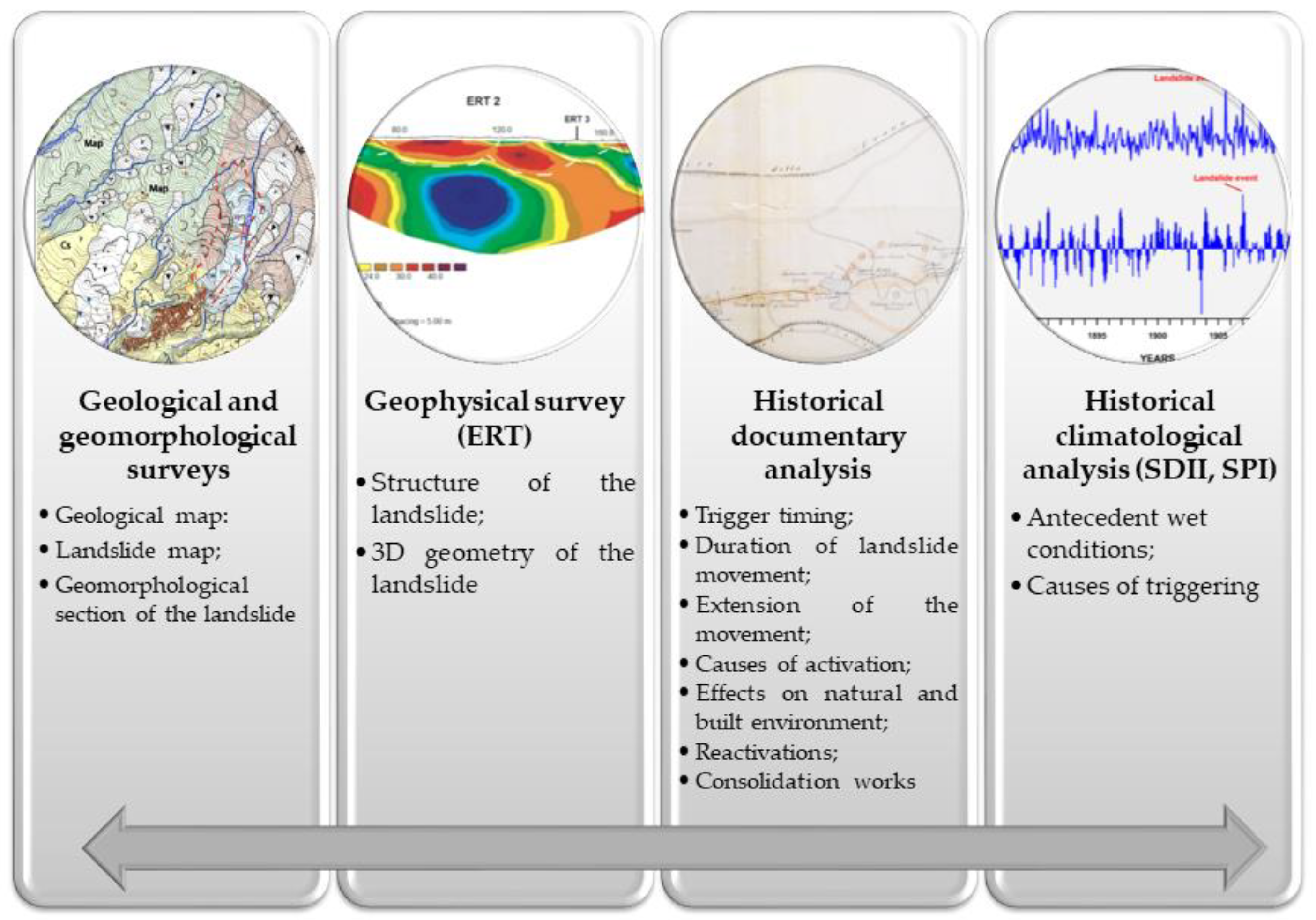
2. Materials and Methods

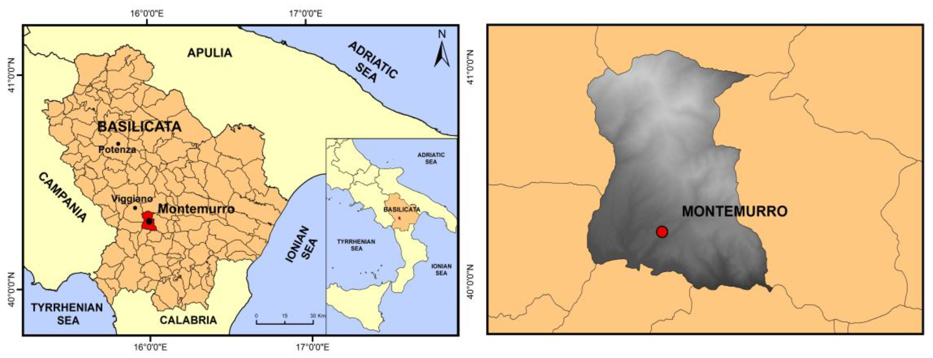
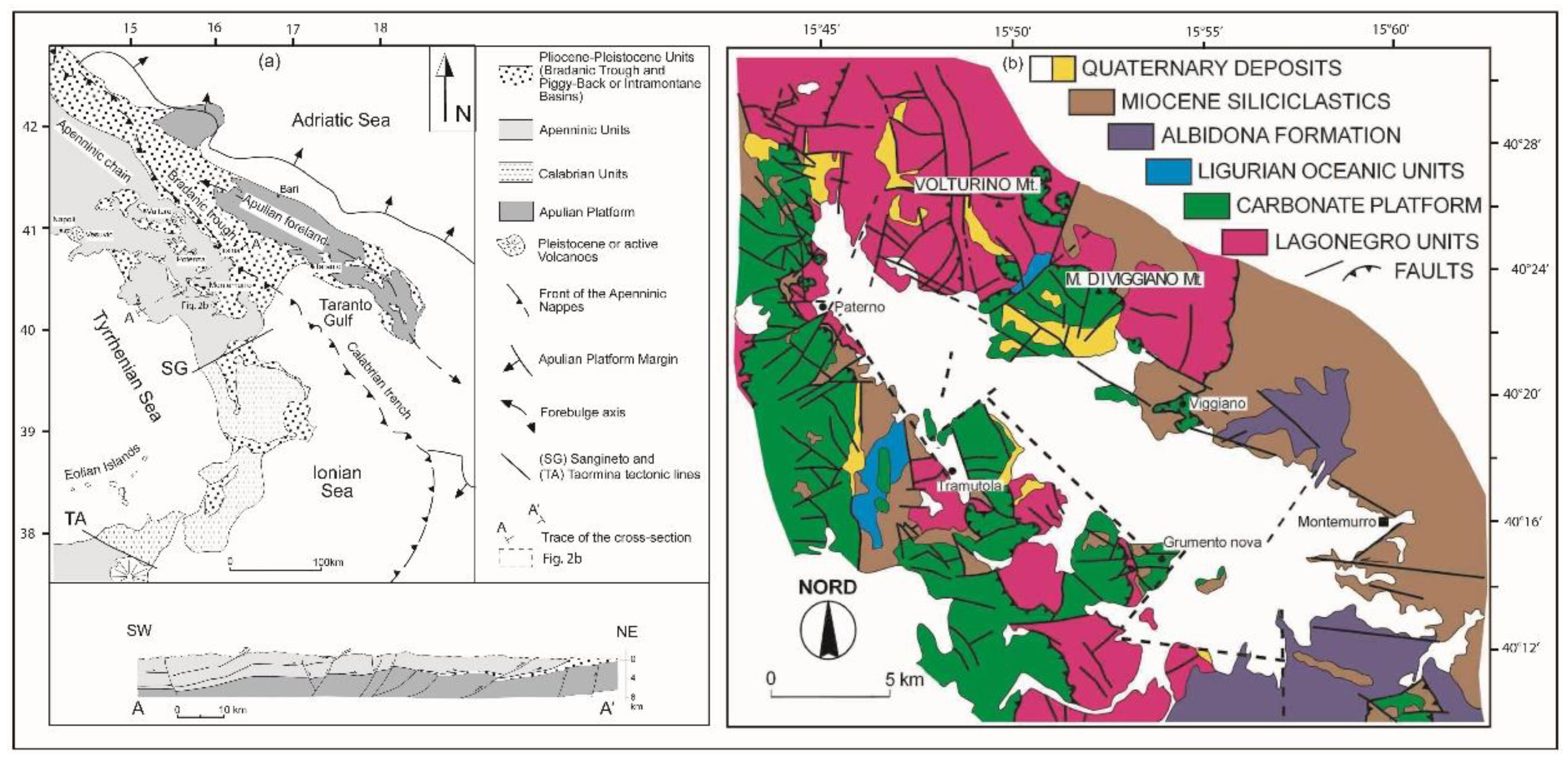
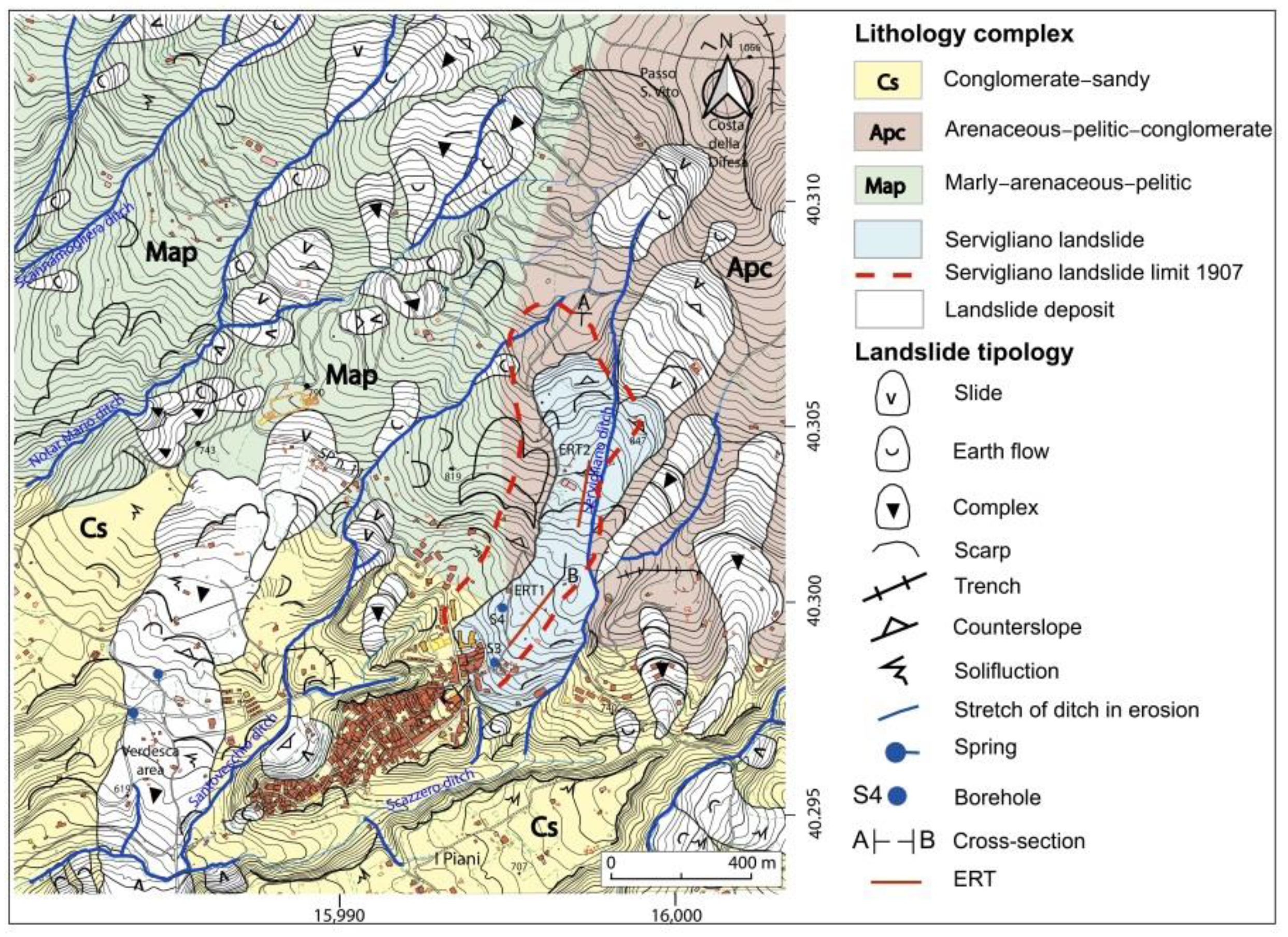
2.1. The Study Area and the Regional Geological Setting

Montemurro is a village located in the Agri Valley in the southern part of the Basilicata region (Southern Italy, Figure 1) at an altitude of 723 m a.s.l. on a relief elongated in a NE–SW direction.
The Agri Valley is a Quaternary intermontane basin located in the hinterland of the southern Apennines. This basin is part of an east verging fold-and-thrust belt developed as an accretionary wedge from the late Oligocene to the early Pleistocene due to the eastward migration of the Apenninic arc [18,19,20,21] (Figure 2).
The present-day configuration of the basin is related to different extensional and transtensional tectonic phases that took place between the Lower Pleistocene and the Holocene, along the fault system known as Val d’Agri Fault System (VAFS) [26,27].
VAFS consists of numerous left-lateral strike-slip faults oriented N120°, associated with compatible kinematics left transtensive faults oriented at N90°/N110° and right, oriented at N30°, in addition to left-lateral transpressive faults oriented at N130°/N150°. The development of these structures involved the Galaino breccias [28] Lower Pleistocene in age, cropping out along the north-western edge of the basin of the high Agri valley. The morphogenetic evolution of the valley would have started from the erosion of a mature landscape, with a small subaerial energy gradient, defined in literature as “summit paleosurface” of Upper Pliocene to lower Pleistocene age offset by faults and currently preserved at different altitudes varying between about 1000 and 1400 m. The syntectonic sedimentary infill of the Agri Valley Basin (AVB) includes a succession only partially exposed at the surface for an overall thickness of approximately 100 m in the south-eastern portion of the basin and sometimes in the north-western part, which is schematized in literature in the following way, starting from the oldest terms:
  • /Breccia di Galaino—slope breccias and equivalent units of the Middle-Lower Pleistocene;
  • Complesso dell’Agri (Agri Complex)—gravel-conglomeratic and sandy-clayey succession of the middle-upper Pleistocene;
  • Terrazzi fluviali, conoidi di deiezione, alluvioni recenti e attuali (Fluvial terraces, fans, recent and actual alluvial deposits)—different orders of terraces correlated to colluvial deposits and slopes in equilibrium with the current morpho-climatic structure of the valley (Upper Pleistocene—present).
In the south-eastern portion of the AVB, the units of the “Agri Complex” and the late Pleistocene–Holocene sediments crop out. The first sediments are correlated to ancient local base levels, which reach heights even above 700 m a.s.l. The latter are different orders of terraces characterised by very small area dimensions and thickness, with progressively lowered base levels up to the current 500 m above a.s.l.

2.2. The Methods

The multilevel and cross-correlated methodological approach (Figure 3) adopted in the research includes geological and geomorphological surveys, geophysical investigations, historical documentary analysis, and historical climatological studies. In particular, we performed new geological and geomorphological surveys, electrical resistivity tomography (ERT) investigations aimed at improving the knowledge of the geometry of the landslide body, analysis of unpublished archive sources to obtain information on the landslide features and its activity over time, and historical climatological investigations to identify the landslide triggering factors.

2.2.1. Electrical Resistivity Tomography (ERT)

In this work, the electrical resistivity tomography geophysical technique was used [29,30,31,32,33] to reconstruct the geometry of the landslide body and to identify the shear surfaces that separate the landslide body from the bedrock [34,35,36].
The ERT technique consists of the injection of a direct electrical current (I) into the ground through two electrodes and the measurement of the voltages (V), revealing the direction and amount of current flow in the subsurface, through another couple of electrodes. The electrodes can be arranged on the ground by using different arrays, each of which is characterized by a geometric factor (K). The measured apparent resistivities (rho_a), obtained by combining I, V and K, can be inverted into true resistivities (rho) by applying an inversion method. In this paper, the inversion software RES2DINVX32 (version 3.71.118), based on the smoothness-constrained least-squares method [30,37,38], was applied to obtain two-dimensional subsurface resistivity models from the apparent resistivity pseudosections.

2.2.2. The Historical Approach

Historical data can be divided in four main groups [39]:
(a)
those that directly record change or occurrence of a natural event (e.g., flood and landslide);
(b)
those that indirectly provide data which can be used to suggest causal or explanatory models (e.g., climatic records);
(c)
other supporting surveys that include relevant information (e.g., geological surveys);
(d)
phenological records which deal with timing (e.g., time of wet season groundwater response).
In our analysis, historical data, particularly that from groups (a) and (b), were considered. Archive documentation was analysed to identify the chronology of the trigger and reactivations of the landslide, the causes of them, the damage effects, the consolidation works planned, and their efficacy over time. Further, climatic records were analysed to determine the cause of the landslide.

The Archive Analysis

The study was carried out mainly through the scrutiny of documentation produced by the Commissariato Civile per la Basilicata (CCB) 1. The sources are currently preserved in the Archivio di Stato di Potenza (National State Archive of Potenza), in the chief town of the Basilicata region.
CCB was established with the law for Basilicata No. 140 of 31 March 1904, also known as the Zanardelli law, and it was suppressed in 1923. CCB was founded as a body responsible for planning, design, and execution of a large number of infrastructure works in Basilicata, as well as for the management of the related funds. Therefore, its aim was also to build infrastructure to consolidate the towns affected by hydrogeological instability [40]. The analysis of documents produced by this body allowed increasing the completeness of both data related to the chronology of the trigger and reactivations of the landslide and the effects caused by the mass movement within the deeper and wider landscape of knowledge of the hydrogeological instability of the Montemurro area.
Beyond these documents, other sources derived from the direct consultation of the Archivio Storico Nazionale del Dipartimento della Protezione Civile 2 (National Historical Archive of the Civil Protection Department in Rome), before the same archive was transferred to the State Archive of Rome.
The sources of that archive amount to about 15,000 documents relating to disasters that occurred in Italy since 1908. The archive arose from several acquisitions from other bodies that were responsible for civil protection before the birth of the Civil Protection Department, established in 1982 at the Presidency of the Council of Ministers [41]. Sources from this archive were useful for analysing the planned partial shifting of Montemurro due to the occurrence of the 1907 Servigliano landslide and the consolidation works performed in the town as well as its efficacy over time. In addition to the archive sources, magazines contemporary to the landslide were also taken into consideration, with particular attention to photographic reporting.
On the whole, the documents analysed were written between the end of the 19th century to the sixties of the 20th century over approximately 60 years. In particular, the most useful typologies of documents consulted were: correspondence between the mayor of Montemurro and CCB; correspondence between the Ministry of Public Works and CCB; technical administrative documentation relating to the consolidation works carried out by firms; correspondence between the Civil Engineer Body and CCB; and resolutions of the CCB board as well as Montemurro town council.

Historical Climatic Analysis

Monthly rainfall and the monthly number of rainy days were collected from the National Hydrographic Service [42]. The data cover the climatological norms in 1885–1914. The aim was to correlate the investigated landslide event with the climate conditions in terms of triggering rainfall and antecedent wetness condition. However, the lack of daily data prevented a detailed analysis for extreme events. To overcome these limitations, we used the monthly simple daily intensity index (SDII) to evaluate extreme events and the standardized precipitation index (SPI) [43] to evaluate previous wetness condition.
SDII represents the ratio between monthly rainfall amount and the number of rainy days that month. It is expressed as mm·day−1.
SPI was used to quantify the precipitation deficits on multiple time scales (1, 3, 6, 12, 24, and 48 months), thus allowing drought conditions to be described for a range of meteorological, agricultural, and hydrological applications. The index was computed by fitting an appropriate probability density function (PDF) to the frequency distribution of precipitation summed over the time scale of interest (usually from 3 to 24 months).
Computation of the SPI involved fitting a gamma function to a given time series of precipitation, with the probability density function (PDF) defined as:
g x = 1 β α Γ α x α 1 e x / β   f o r   x > 0 ,
where α > 0 is a shape parameter, β > 0 is a scale parameter, x > 0 is the amount of precipitation and Γ(α) is the gamma function. Fitting the distribution to the data requires α and β to be estimated for each month of the year and for each time aggregation. The parameters α and β can be estimated as follows:
α = 1 4 A 1 + 1 + 4 A 3 ,   β = x _ α                         w i t h   A = l n l n   x _ l n l n   x   n  
where n is the number of observations. The cumulative distribution function (CDF) G(x) is defined as:
G x = 0 x g x d x = 1 β α Γ α 0 x x α 1 e x / β d x   ,
Due to the possibility to have several zero values in a sample set, since the gamma distribution is undefined for x = 0, the CDF for the gamma distribution is modified as:
H x = q + 1 q   G x ,    
where q is the probability of zero precipitation, given by the ratio between the number of zeros in the precipitation series (m) and the number of observations (n). The CDF is then transformed into the standard normal distribution to yield the SPI as:
z = S P I = t c 0 + c 1 t + c 2 t 2 1 + d 1 t + d 2 t 2 + d 3 t 3 ,   t = l n 1 H x 2         f o r   0 < H x < 0.5 ,
z = S P I = + t c 0 + c 1 t + c 2 t 2 1 + d 1 t + d 2 t 2 + d 3 t 3 ,   t = l n 1 1 H x 2         f o r   0.5 < H x < 1 ,
where c0, c1, c2, d1, d2 and d3 are mathematical constants.
Although the SPI index follows a classification restricted only to drought periods, it has become customary to use the index to classify wet periods as well. Table 1 reports the climatic classification according to the SPI, provided by the National Drought Mitigation Center (NDMC, http://drought.unl.edu, accessed on 18 November 2021).

3. Results and Discussions

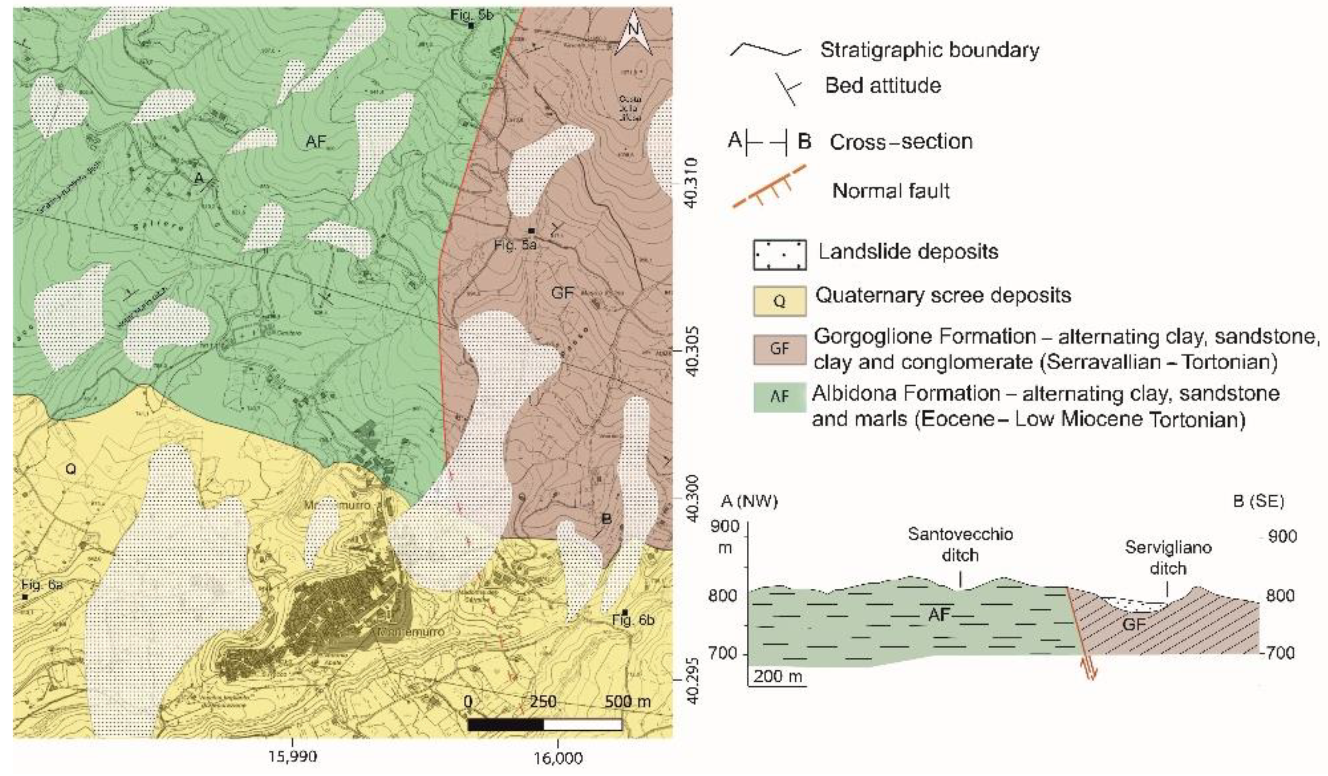
3.1. Geological and Geomorphological Settings of the Montemurro Area

3.1.1. Geological Setting

A new geological survey allowed us to delineate in detail the geological structure of the area, the stratigraphic relationships, and the tectonic structures affecting the different outcropping formations, as shown in the geological map in Figure 4.
The outcropping rocks can be assigned to both the Gorgoglione Formation [44], which constitutes the pre-Quaternary bedrock of the studied area, and Quaternary alluvial.
The Gorgoglione Formation was deposited in a piggy-back basin during the compression phase of the Apennine orogeny, which gave rise to the Irpino Basin [45,46,47,48,49,50,51]. The Gorgoglione Formation consists of a succession made up of massive, well-cemented, coarse sandstones, with variable colouring from whitish to yellowish, alternating with grey pelitic intervals or polygenic and polymetric conglomerate with abundant sandy matrix (Figure 5a). The formation shows a general bed attitude with the beds dipping mainly towards the NE, which gives rise to the reliefs that dominate the inhabited centre of Montemurro at an altitude of about 1000 m a.s.l. However, the northern part of the urban area of Montemurro was built directly on the Miocene arenaceous substrate. The remaining part of the village was built on Quaternary deposits.
Other outcrops of the Gorgoglione Formation were identified in the north-western part of the study area, along the deep valley cut by the erosion of the Saliere, Notar Mario, and Scannamogliera ditches.
The pre-Quaternary bedrock, which is better exposed along incisions and ditches, consists of banks of whitish quartz sandstones.
The Miocene substrate also crops out along the right side of the Scazzero ditch, south-west of the town of Montemurro, coinciding witha tectonic structure with a NE–SW trend that involves the Pleistocene sands. In this outcrop, the Gorgoglione Formation is very tectonised.
In the rest of the study area, the arenaceous sequence prevails, with more or less extensive outcrops consisting mainly of greyish quartz limestone sandstones with marly or centimetric clay intercalations belonging to the Albidona Formation (Figure 5b).
The arenaceous beds show thicknesses ranging from a few decimetres to a few meters. Beds with a greater thickness show an evident normal gradation [52]. The contact between pelitic and the arenaceous intervals is generally sharp. In the Passo San Vito area, intraformational sliding structures (slumps) have been observed.
In the study area, the Gorgoglione Formation rests discordantly on the Albidona Formation, which extensively emerges further west. Pleistocene sandy deposits lie unconformably above the Gorgoglione Formation. The stratigraphic contact between the two formations is rarely exposed within the surveyed area since it is commonly covered by slope and/or landslide debris. The on-lap geometry of the contact occurs at Largo S. Antonio, 710 m a.s.l., in the Montemurro centre.
The Quaternary succession exposed in the area consists of middle Pleistocene-Holocene wedge-shaped continental clastic deposits [53]. These unconformably lie on the Gorgoglione Formation deposits. These are deposits associated with alluvial plains and alluvial plains and correspond to those identified in the intermediate and upper range of the Val d’Agri complex, as described by Di Niro et al., (1992, 1995) [54,55].
More recently, these Pleistocene deposits were described by Zembo et al., (2010) [56]. They consist of poorly graded conglomerates and clast-supported gravels, with a reddish sandy matrix alternating with sandy gravels. The clasts are mainly derived from the Gorgoglione Formation. Rarely, calcarenitic, siliceous, igneous, and metamorphic clasts are also observed. The dimensions range from centimetric to decimetric and are generally slightly rounded. These deposits crop out at the top of the morphological terrace on which the south-western part of the Montemurro village rests, along the incision of the Santovecchio ditch and along the right side of the Scannamogliera ditch. The best exposed outcrops can be seen on the subvertical walls on the left of the Scazzero ditch (Figure 6b).
In the southern part of the studied area, the deposits consist of sands, from coarse to very fine, interstratified with clays and clayey silts with colours varying from grey to olive green. Sometimes, the finer horizons have a high content in organic matter and are also characterized by ferrous reddish-brown or calcareous whitish concretions. Upwards, a gradual increase in grain size can be observed in gravels and massive conglomerates with heterometric clasts of various kinds and sandy matrix of red-brown colour. Conglomerates are often interstratified with coarse sands and lens-shaped silty bodies [57,58] (Figure 6a).
The morphological structural framework of the area was carried out on the basis of observations made on aerial photos and in the countryside during the geological survey. Furthermore, a previous geoelectric survey [57] greatly supported the understanding of the geology of the area by interpreting the numerous tomographic profiles.
The morphological evolution of the area is conditioned by two main mainly normal fault systems, with NW–SE and NE–SW trends, and part of a regional system known as the Val d’Agri fault system (VAFS, [27] and references therein).
On the one hand, the NW–SE system created a stepped structure, which favoured the development of a structural depression with significant deepening towards SW of the pre-Quaternary substrate represented by the Gorgoglione Formation. The most important fault of this system is transtensive, with an Apennine trend, south of the Montemurro cemetery. A similar structure is found further upstream along the provincial road that connects Montemurro to Viggiano (Figure 1) and places the Miocene substrate in contact with the Quaternary sandy deposits, in correspondence with a box-like structure due to two other transtensive faults with an anti-Apennine course. Another contact between the Miocene substrate and the Quaternary deposits was observed close to the inhabited centre of Montemurro, in correspondence with a normal fault, which lowers the south-western part. On the other hand, the NE–SW dislocation system, with an anti-Apennine trend, consists of faults with a prevalently normal component but with often antithetical vergences that favour the development of horst and graben-type structures. This system influences the arrangement of the ridges, stretched in the NE–SW direction, and the trend of the hydrographic network. One of the most important structures of this system is represented by a fault with a prevalently normal component along the Scazzero ditch. Corresponding to this is contact between the Miocene substrate, which emerges along the right side of the ditch and the Quaternary deposits outcropping on the opposite side.
Other recognisable morphological elements are the terraced surfaces, consisting of alluvial deposits and bordered by escarpments with high slopes. Among these, the most evident are the flat surface on which part of the town of Montemurro was built and the vast area called “I Piani”, separated from the previous one by the incision of the Scazzero ditch. The morphological terrace, on the hydrographic left of the ditch, still preserves the morphology of the old fan, which consists of a residual edge, similar to that which can be observed south of the cemetery.

3.1.2. Geomorphological Setting

The results of the new geomorphological analysis carried out in the studied area are reported in the sketch map of Figure 7.
The western side of the village of Montemurro is characterized by an obvious slope change controlled by the different strength of the outcropping lithologies. The presence of alternating turbidite sandstones, siltstones, and silty clays in the northern sector produces steeper slopes than the southern sector, where Quaternary deposits consisting of conglomerates, sands, and clays outcrop.
The area is characterized by a wide geomorphological instability involving the entire right slope from the Scazzero ditch, 810 to 590 m a.s.l. and 1500 m in length. Landslides mainly affect Quaternary continental deposits of the Val d’Agri Basin and, in the topmost slope sector, the Gorgoglione Formation sandstones. In some cases, it is possible to recognize landslide main scarps, minor scarps, terrace-like features, and counterslopes, which are particularly pronounced along the southern sector of the slope. Geomorphological trenches in the foothills of fault scarps and landslide niches have also been observed.
An impressive pre-1954 quiescent landslide involved the entire area delimited by the road from Montemurro to the cemetery to the north, by the Montemurro high to the east, by the conoid south-westward of the cemetery to the west and by the Scazzero ditch to the south. The damaged area is about 40 ha, and subsoil geological structures have been completely reworked and altered. The entire area is still active and has been affected by many smaller landslide events. Now, the main landslide activity affects the slope in the Verdesca area, where significant evidence of ongoing activity has been observed; this consists of structural damage to infrastructure and anthropic buildings (e.g., dislocation of SP n. 11 road tunnel box, warping of retaining walls, and deformation of road embankments, road surfaces, and old man-made structures; Figure 7 [57,58,59,60,61]).
The area has been affected by a complex landslide, about 700 m long and 325 m wide, developed between 675 and 590 m a.s.l., with a maximum elevation difference of about 85 m between the upper and the lower portions of the landslide body. The size of the damaged area is about 20 ha. The steepness of the landslide body in the accumulation area is about 14°, while it is about 12° in the source area. In the upper sector, this landslide is a rotational slide, evolving, in the lower part, into a flow [62,63]. The landslide foot has been affected by further superficial movements, due to the continuous erosion of the Scazzero ditch, whose course is diverted in relation to the zone accumulation.

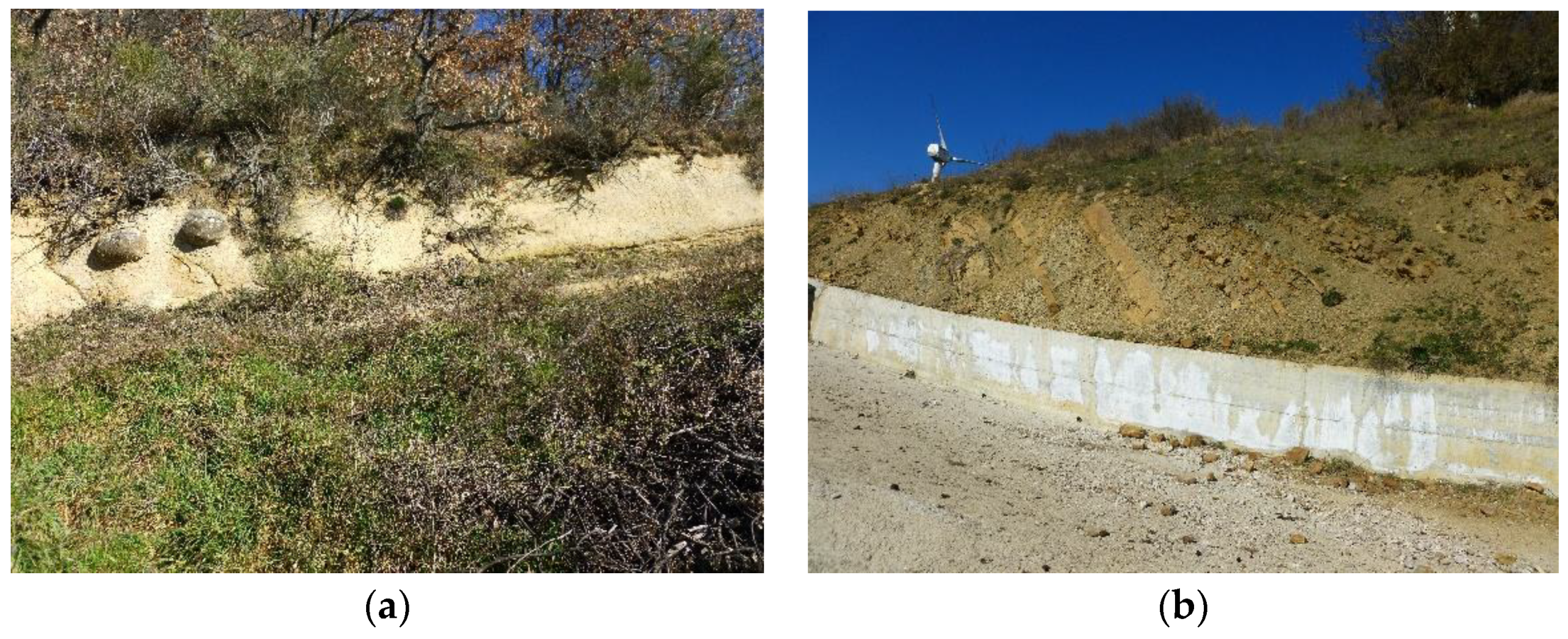
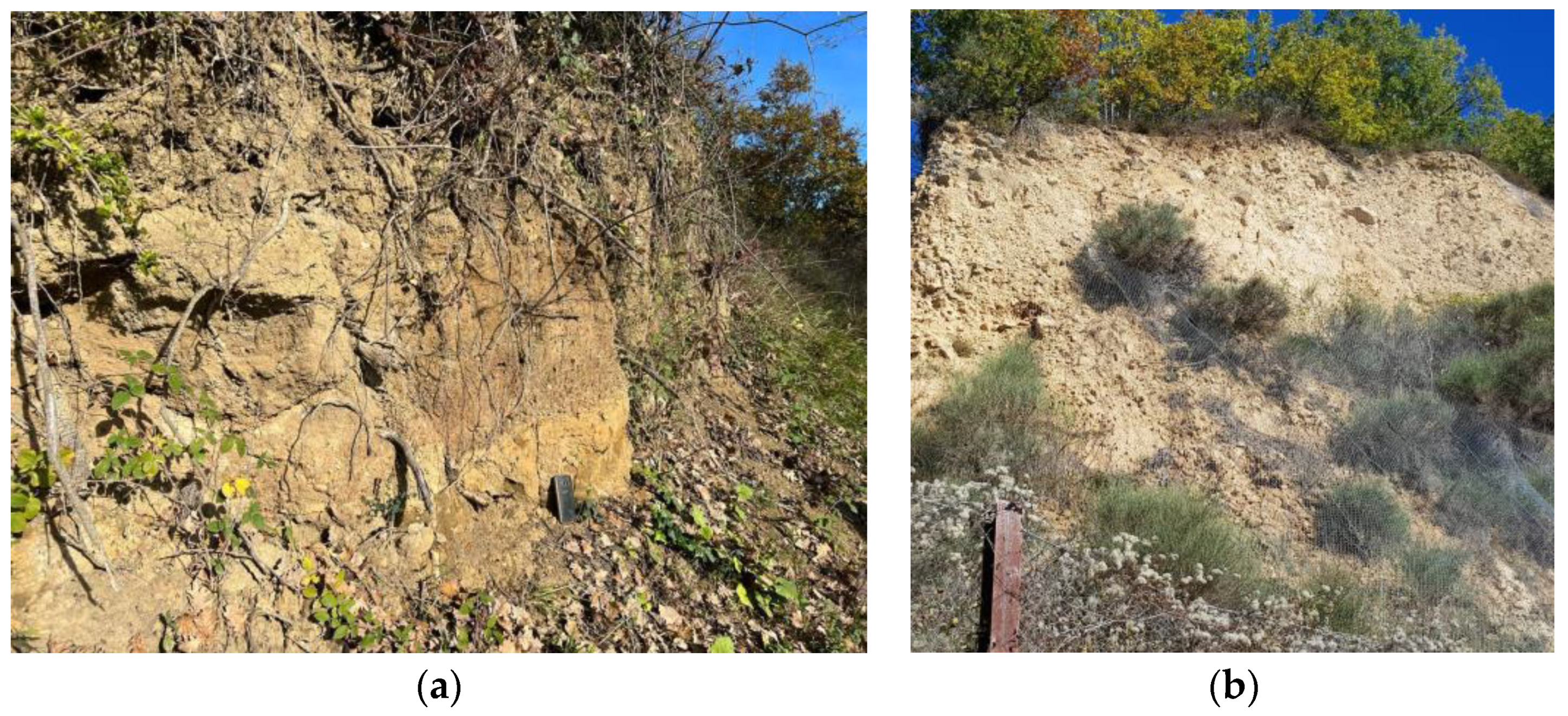
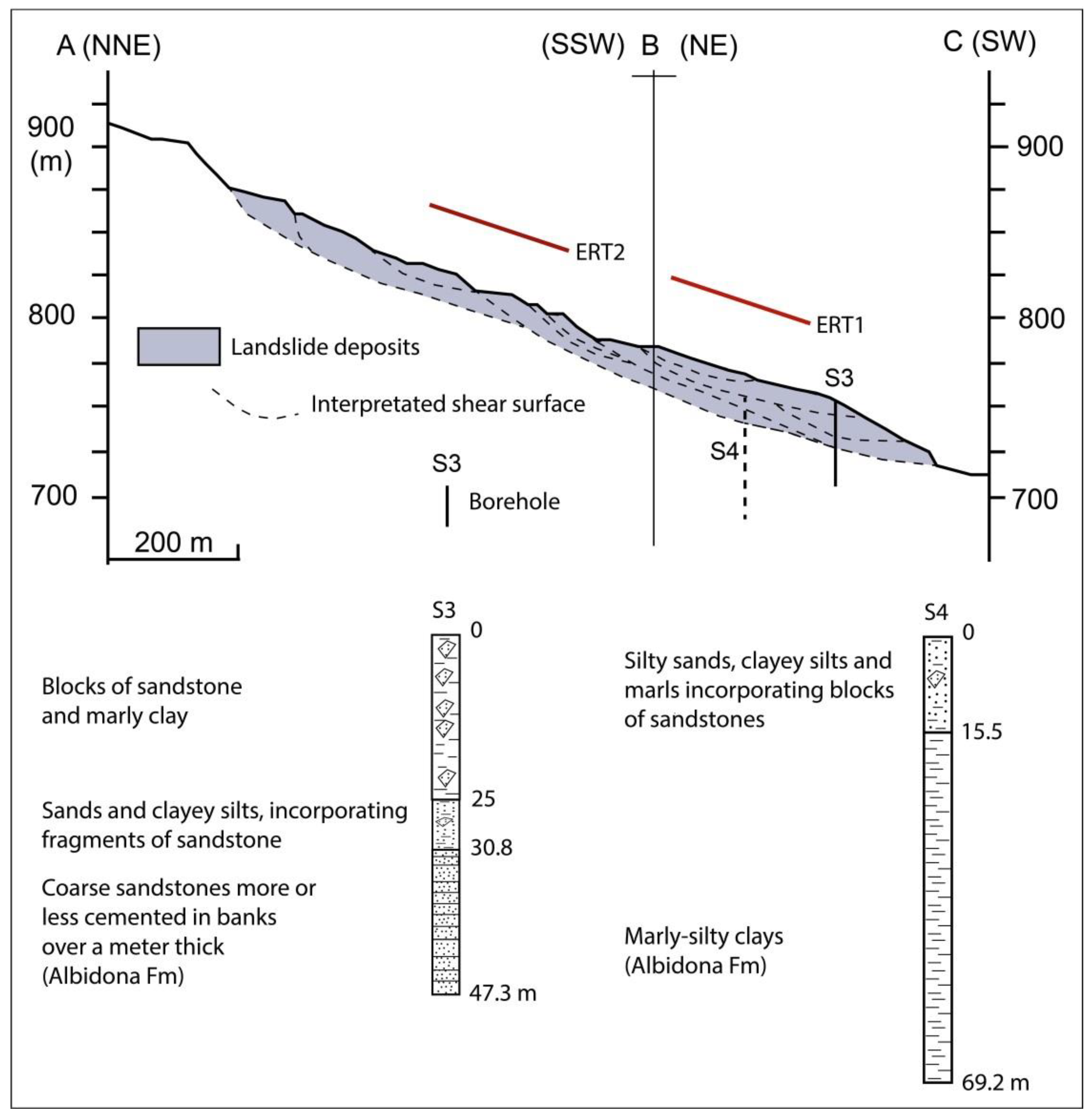
3.1.3. The Servigliano Landslide

The comparison between the current landslide map of the area and historical sources (see Section 3.3.1. allowed us to geometrically identify the Servigliano landslide. The mass movement was activated on 26 February 1907 and originated near Coste della Difesa, north-east of Montemurro village, where the niches of detachment, and affects much of the southern slope of “Passo di San Vito” (1050 m a.s.l.) (Figure 7).
The Servigliano landslide of 1907 can be classified as an “earth flow”, extends for about 1000 m, and has an average width of about 280 m. The depletion zone is located at about 1050 m a.s.l. while the toe zone foot reaches 700 m a.s.l. covering a difference in level of 350 m (Figure 8). The last evident reactivation of the landslide took place in June 1921.
The landslide body has an average slope of about 10°. Over time, the main landslide body has been affected by smaller and more superficial landslides that have mainly affected the toe zone, caused by the continuous erosion exerted by the Scazzero ditch that flows in the south-eastern part of Montemurro. The landslide movement mainly affected the deposits of the Gorgoglione Formation, while only in the terminal part, near the town, did it involve the Quaternary deposits. During the activation in 1907, the landslide partially filled the Servigliano ditch, and the foot of the landslide involved the north-eastern part of the urban area, causing significant damage, to then reach the Scazzero ditch. The deposits of the landslide toe zone are delimited on the left by the terminal part of the Servigliano ditch and on the right by a small ditch that feeds down Santovecchio ditch. In particular, the Servigliano landslide begins with two very distinct escarpments that have generated evident terraces beyond which, towards the bottom, the landslide body evolves by flow. The elongated landslide channel extends from NNE to SSW. In the terminal part, landslide deposits have assumed a fan arrangement north of the town and the Scazzero ditch, which flows in the south-eastern part of Montemurro.
There are no data available concerning the depth of the sliding surface, which would be necessary to reconstruct the geometry of the landslide body. Inside the landslide body, two sources for surfacing the piezometric surface were identified, located at the base of detachment niches. Currently, the Servigliano landslide of 1907 appears to be dormant.

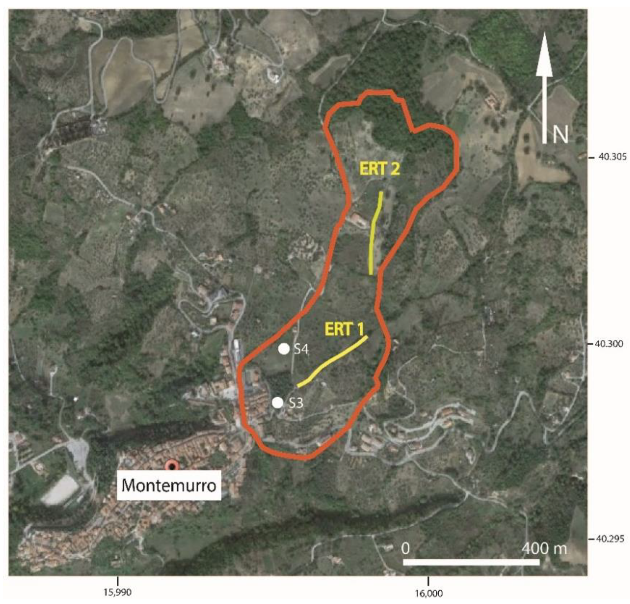
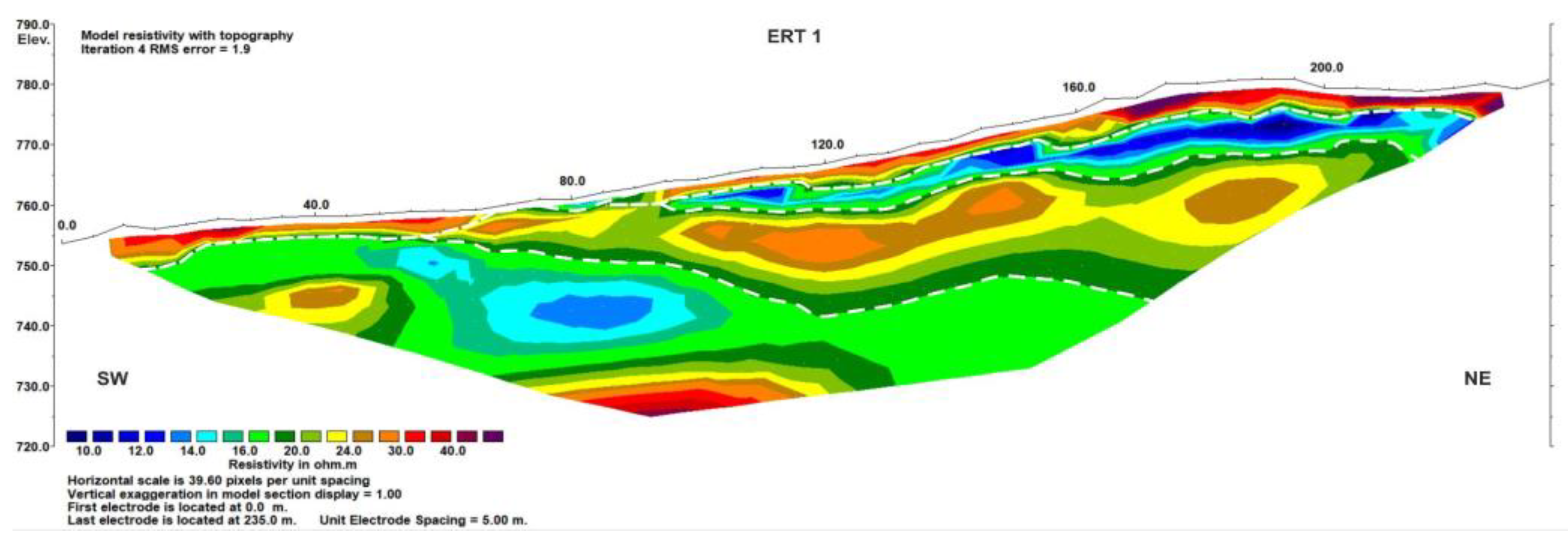
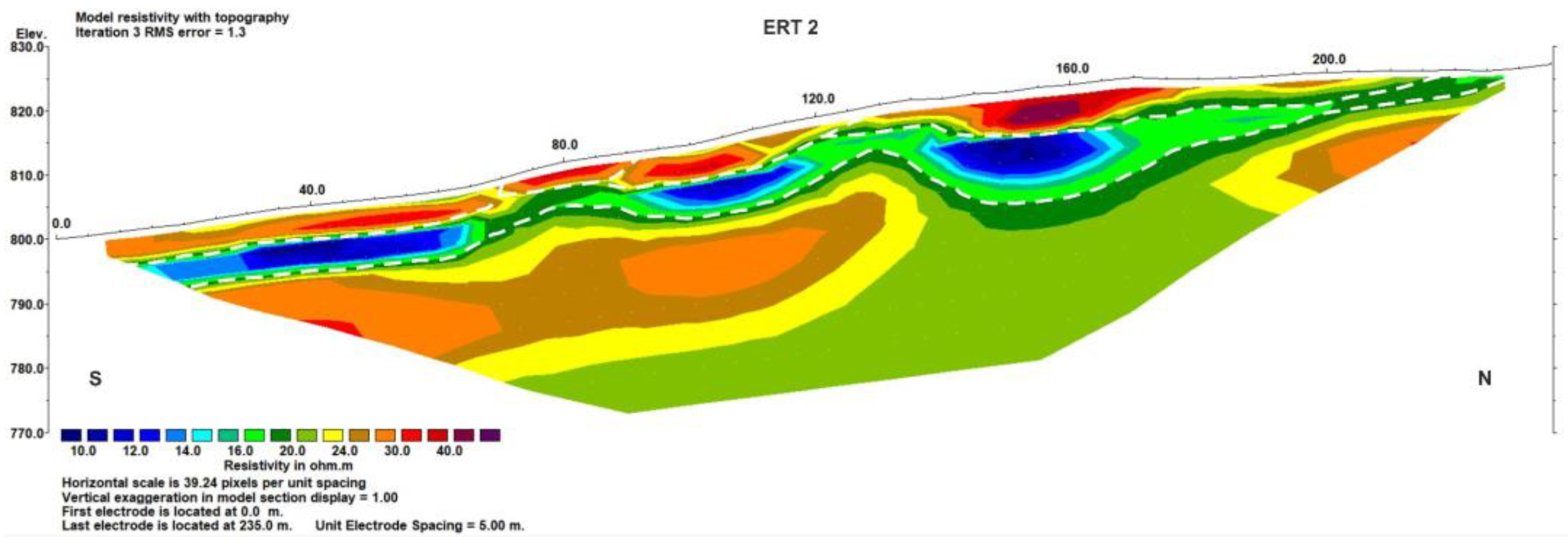
3.2. Electrical Resistivity Tomography (ERT)

The measurements were carried out along two profiles by using the georesistivimeter Syscal Pro Switch 48 connected to multielectrode cables with 48 electrodes arranged following the Wenner–Schlumberger array and spaced 5 m from each other. The obtained resistivity models were 235 m long and reached an investigation depth of about 40 m (Figure 9). ERT results were interpreted taking into account the geological and geomorphological setting of the area and the borehole data (S3 and S4).

ERT Analysis and Interpretation

ERT were carried out in two different sectors of the landslide parallel to the main axis of the body. They are characterised by a resistivity range limited between 10 and 40 ohm·m, mainly due to the clayey matrix of the terrains outcropping in the area.
ERT1 (Figure 10), located in the landslide foot, shows a succession of resistive and conductive layers, up to 20–25 m in depth, overlying a thicker conductive layer. In the deep portion of the ERT, in the south-western side, an increase of the resistivity is observed.
According to the stratigraphical information inferred by the boreholes (S3 and S4) and the outcropping terrains in the area (Albidona Formation), the resistivity distribution characterising the first 20–25 m of the subsoil could be due to the presence of silty sands, clayey silts, and marls layers incorporating blocks of sandstones. The thicker and deeper conductive layer could be associated with the marly-silty clays and the deep resistive sector could be associated with a bank of cemented sandstones. The dashed white lines, drawn in the ERT, outline possible sliding surfaces related to different reactivations of the landslide body.
ERT 2 was carried out parallel to the landslide body along the middle part (Figure 11). The resistivity model shows an almost piano-parallel electrostratification. According to the geological map (Figure 4), the succession of resistive and conductive layers could be associated with sandstone/conglomerate and clay material, respectively (Gorgoglione Formation). Supposed sliding surfaces (dashed white lines), up to 15 m in depth and related to different reactivations of the landslide body, are delineated on the electrical image.

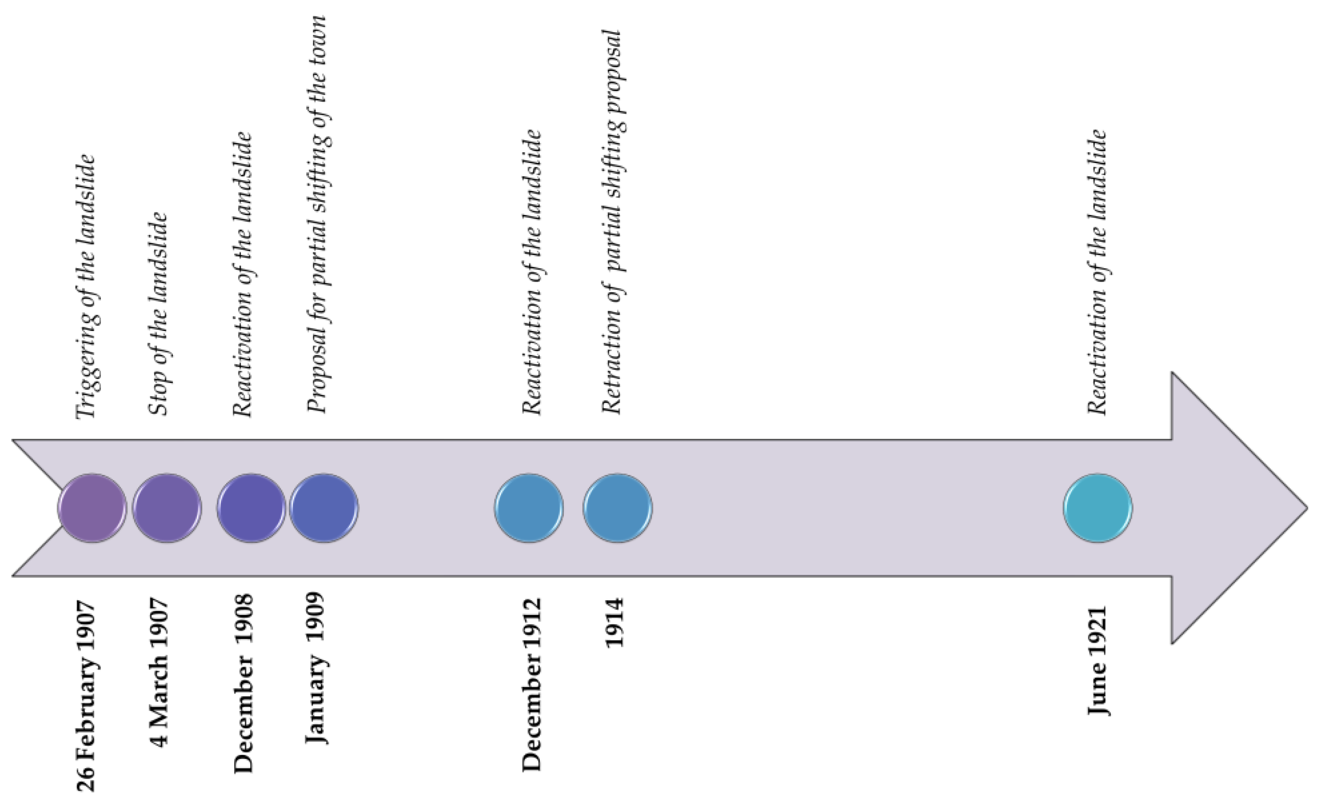
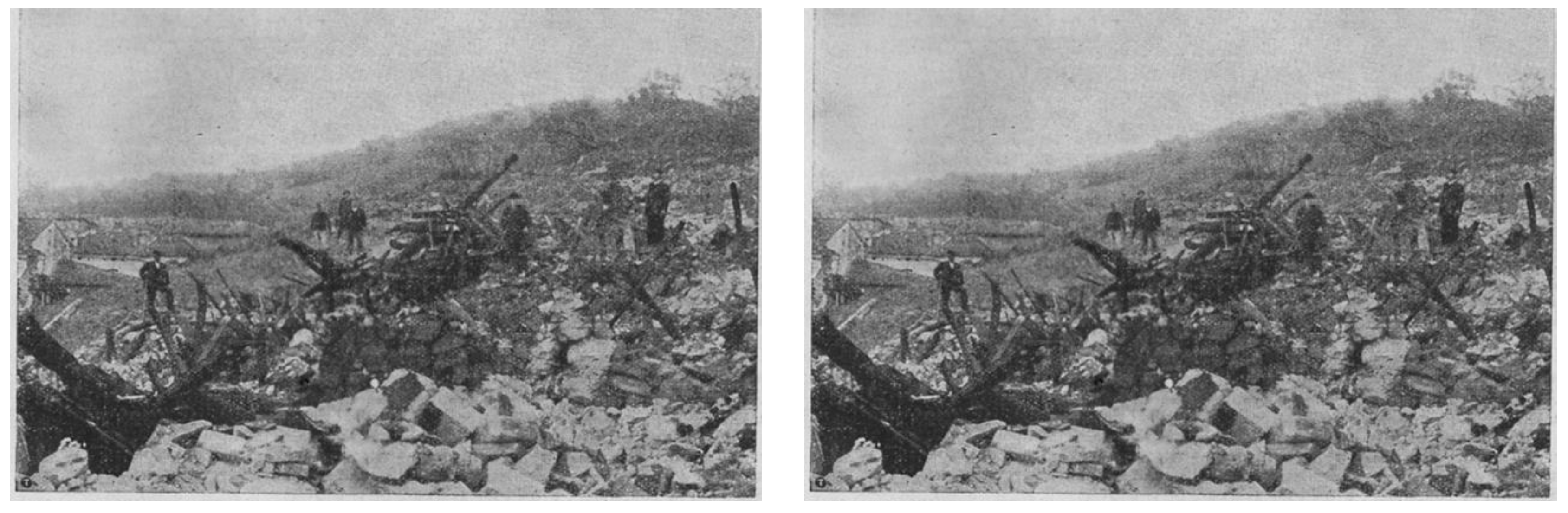
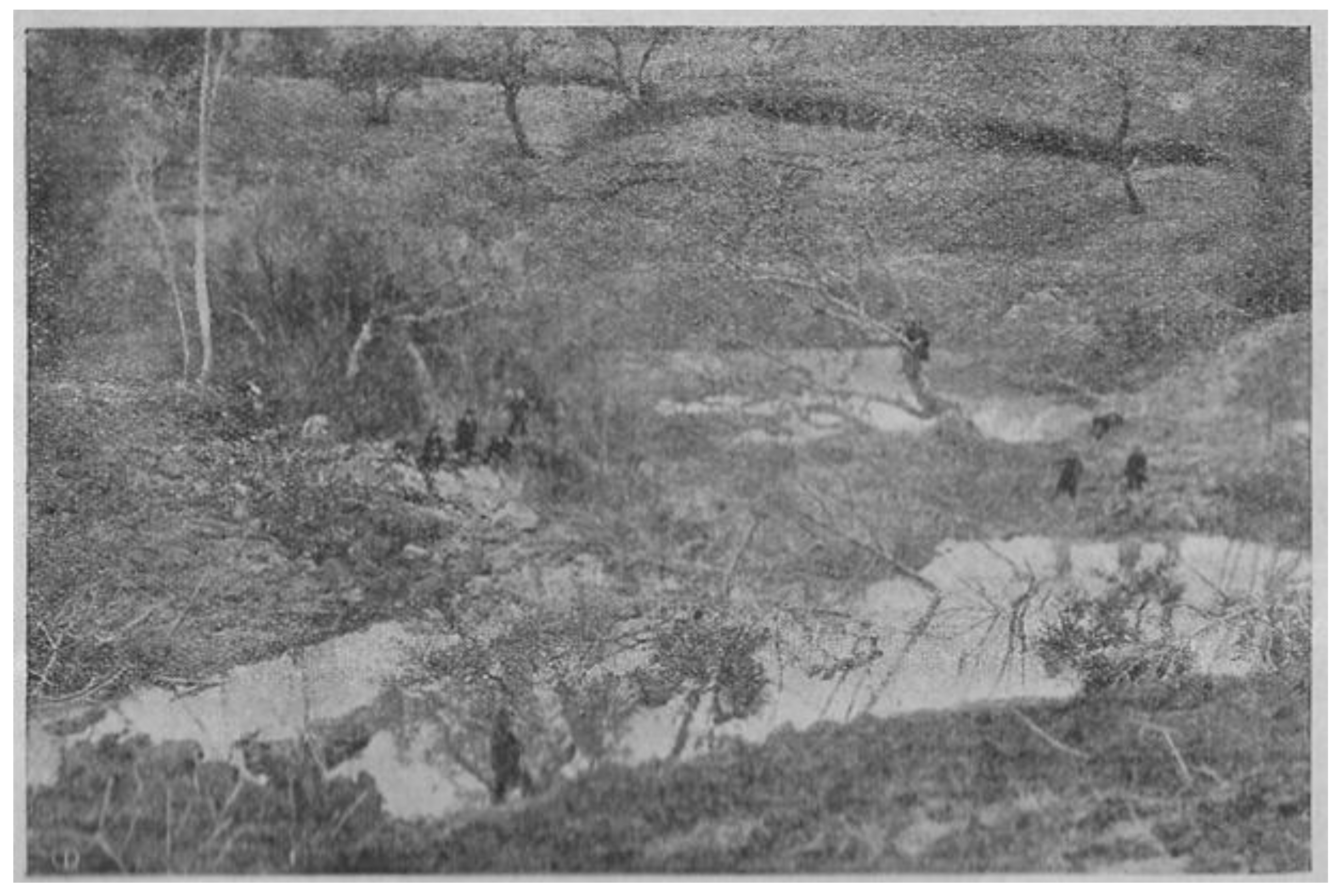
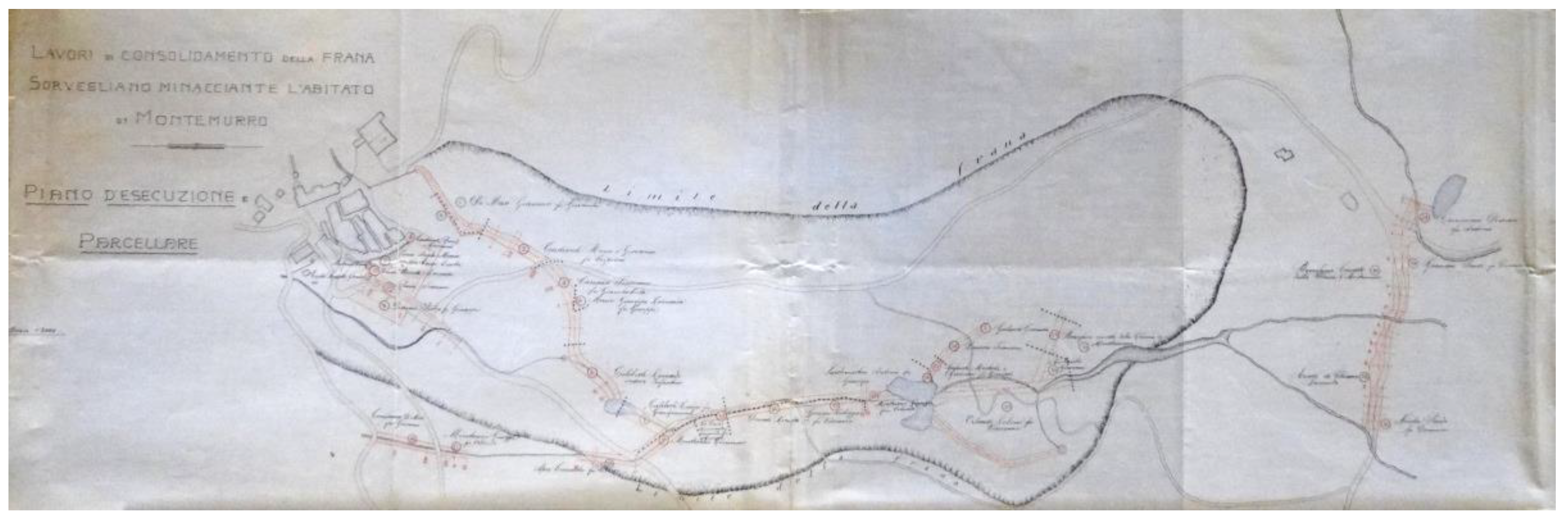
3.3. The 1907 Landslide Analysed by Historical Data

3.3.1. The Contribution of Archive Sources

The municipal area of Montemurro is prone to landslides, as also testified by previous studies. For example, Almagià (1910) [64] reported some mass movements starting from the first half of the 19th century. Such phenomena were also triggered by seismic activity, such as the earthquake of Lagonegro of 20 November 1836 (Mw 5.9, [65]), and particularly the disastrous 16 December 1857 Basilicata earthquake (Mw 7.1, [65]) which caused a giant landslide in Montemurro. In the decades following the 1857 earthquake, particularly in the last two decades of the nineteenth century and the early twentieth century, Almagià also refers to further landslides in the southern portion of the town and in many areas around it.
In the following years, and in particular in 1907, a wide landslide was activated at north-east of the historical centre, in the Servigliano area. To improve the knowledge on this landslide, we performed a wide investigation on unpublished archive sources.
The landslide was triggered in the early hours of 26 February 1907 (Figure 12). The phenomenon occurred after eight days of intense rainfall, during which a quantity of water fell equivalent to one third of the rain that fell in the entirety of rainiest year of the previous 22 years. In this period, other landslides were triggered in the municipalities within a radius between 8 and 45 km, such as in San Martino d’Agri (March 1907), 8 km south of Montemurro; Aliano (spring 1907), 20 km east; Senise (1906–winter 1907), 25 km south-east; Tursi (15 February 1907), 40 km east; Teana (between 10 and 15 February 1907), 45 km south [64,66] 4.
The area hit by the Servigliano landslide was not known, at least until 1907, as susceptible to sliding down. In fact, in the aftermath of the devastating 1857 Basilicata earthquake, which razed the entire town to the ground, the Servigliano area was even hypothesised as a place suitable to transfer and rebuild the town. Moreover, technical documents related to the consolidation plan of the landslides in Montemurro dating back to the end of the 20th century (1899) do not include the Servigliano area. These findings are also in line with the analysis of the historical topographic map of the area (scale 1:50,000) whose survey was carried out by the Istituto Topografico Militare (Military Topographical Institute) in a period between the sixties and seventies of the nineteenth century 5 (ITM, 1862–1876). Indeed, the contour lines of this map do not supply evidence of morphology related to the landslide.
The ground movement had a height of about 40 m in the detachment area. The landslide destroyed, in the following hours and days, the entire Rione Carmine (Carmine quarter) consisting of about thirty houses, the church, and the Servigliano Chapel, as well as many other houses in the Rione Concerie (Concerie Quarter), at the edge of the north-eastern part of the town. The movement also caused extensive damage to local road infrastructures and sewage collectors and very serious damage to the olive groves and vineyards, which were destroyed (Figure 13). Fortunately, the landslide did not cause deaths since the inhabitants were able to evacuate their homes.
On the third day, the landslide body was overestimated to have a length of about 2 km and a width of comparable dimensions. Four days after the first movement, the landslide continued to move, damaging some houses located on the rocky spur that still today characterises the entrance to the town from the Rione Concerie.
The movement of the front of the landslide stopped on 4 March, about a week after its triggering, when the works of clearing the rubble, completed in September 1907, and diversion of the waters also began. In fact, multiple depressions were formed inside the landslide body, which led to the formation of ponds (Figure 14 and Figure 15).
To mitigate the residual risk related to houses located close to the landslide front (10 m high) towards the built-up area, further drainage works of the stagnant water were planned between 1907 and 1909, as well as the hydraulic forestry arrangement of the ditches below the inhabited and unstable areas. In fact, about 15 months after the trigger of the earth flow, water stagnation continued to cause movements of the landslide, so much so that the town council requested further reclamation work by CCB.
Works planned in 1907–1909 included the removal of the landslide deposit close to the town and the building of a retaining wall at the foot of the unstable body. In June 1911 some works were carried out including clearing of the debris that had partially invaded the town, construction of a retaining wall, and excavation of drainage ditches for the drainage of water from the landslide drainage. Civil engineers did not consider the drainage sufficient, and several homeowners in Rione Concerie in December 1912 complained about the movement of the landslide and the presence of stagnant water in the unstable body, especially in summer. However, the construction of the supporting wall at the foot of the landslide body was ineffective because towards the end of December 1908 part of the wall collapsed while the remaining portion was heavily damaged, thus evidencing progression of the earth flow movement.
The late motion of the landslide brought about the proposal to partially move the town, with particular regard to the first row of buildings placed on the landslide front. The proposal was put forward in January 1909 on the basis of Law No. 445 of 1908, which aimed to supply economic provisions to strengthen or transfer the towns affected by landslides. However, the transfer was slow and bureaucratic and the proposal was abandoned definitively in 1914. This occurred because owners had already voluntarily rebuilt the landslide-damaged homes in other areas of the town and the landslide area was involved in extensive consolidation work in the 4 years following the trigger of the mass movements. Furthermore, after 1914, this same area underwent extensive and definitive consolidation works to strongly mitigate the risk. The project was authorised by the Ministry of Public Works in January 1912 and included the expropriations for public interests aimed at executing the consolidation works, including the drainage of rain and spring water from the landslide area by masonry gutters. However, the landslide was still moving in December 1912.
In January 1915 and December 1916, due to the persistent rains, landslides were also triggered in other urban areas. This activity required the attention of the authorities for the safety of the inhabitants and the execution of consolidation works.
In November 1916, consolidation work on the Servigliano landslide was yet to be carried out. From the analysis of the direct survey of the area, as reported in the project of the consolidation works drawn up by the Royal Corps of Civil Engineers dating back to 15 November 1916, the extension of the landslide was evaluated in a maximum length of ~1.1 km, with a maximum width of ~400 m and a minimum width of ~300 m (Figure 15). At that date, significant residual areas of water stagnation still persisted, as the map at Figure 15 shows.
The landslide was reactivated at the beginning of June 1921 when the first houses facing the landslide front began to be obstructed again by the chaotic mass, which was likely also caused by the lack of arrangement of the surface waters in the body of the landslide. The landslide consolidation works, however, had likely not been carried out by this date; the Mayor of Montemurro in a telegram to the Ministry of the Interior controversially emphasised that “[…] Invano la Giunta Comunale ed il Consiglio hanno fatto voto per la sistemazione di detta frana […]. Quando i danni saranno irreparabili allora arriverà l’opera riparatrice che potrà essere anche di pannolini caldi […]” (It was in vain that the town councils voted for the consolidation of the landslide […]. When the damage is irreparable, then the remedial work will arrive, which may also include hot napkins […]) 7.
The civil engineers of Potenza in the general consolidation interventions of the town of Montemurro scheduled in the 1960s still indicated numerous works as necessary, including drainage, waterproofing of the streets of the town, and the construction of retaining walls. The area involved in the works also included the north-east portion of the town facing the landslide.

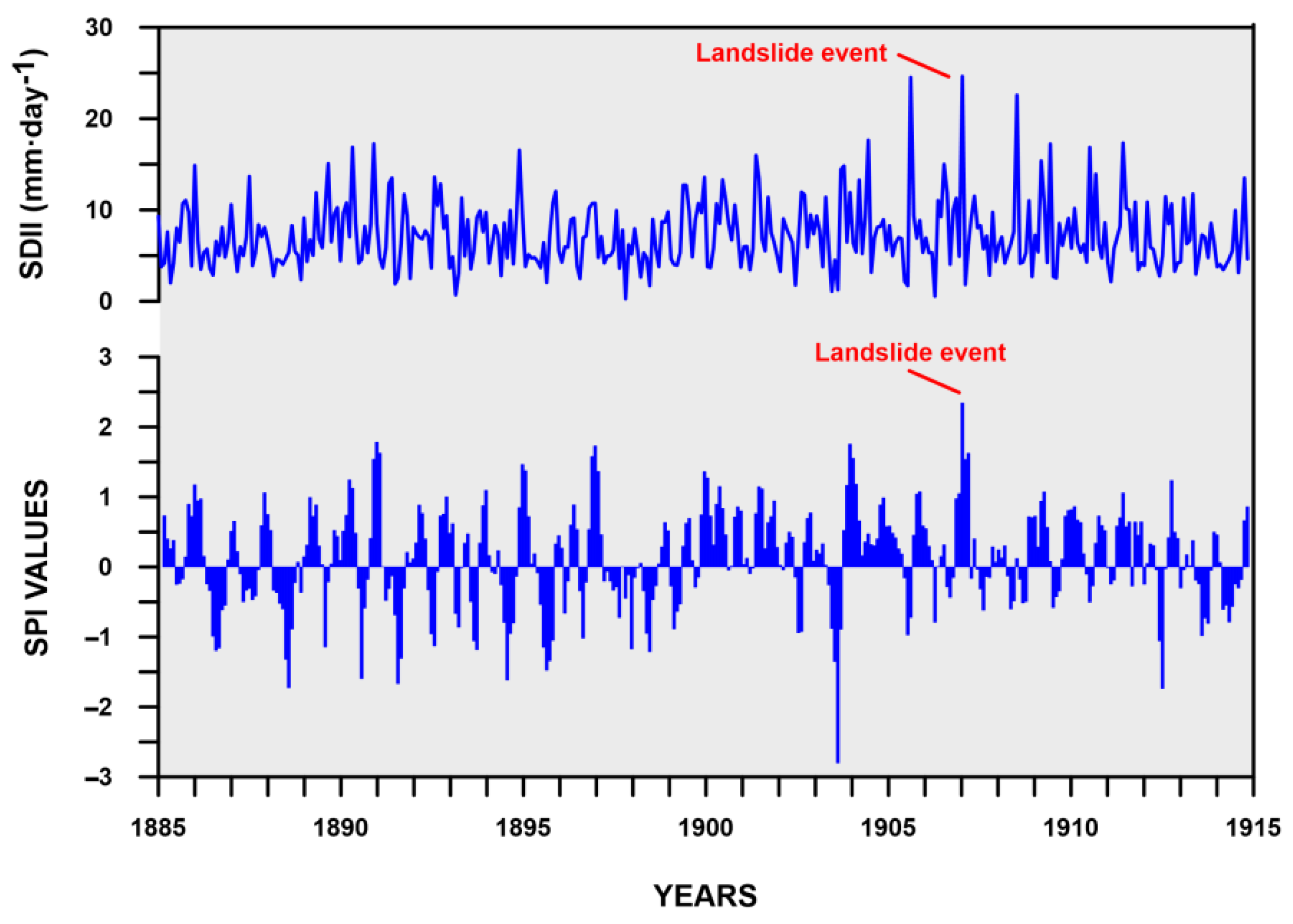
3.3.2. Historical Climatic Data Analysis and Interpretation

The monthly total rainfall from 1885 to 1914 was analysed and the results are shown in Figure 16. For each year, the monthly rainfall was added together to realise the total annual rainfall. Then, the average annual rainfall from 1885 to 1914 was calculated. It corresponded to 780.2 mm·year−1. The SDII index shows a high variability from one year to another, with three main peaks in September 1905, February 1907, and August 1908. In February 1885, a landslide event worth mentioning in the chronicles of the time occurred [68]. The monthly rainfall in February 1907 was 369.5 mm, a large amount corresponding to more than half of the average annual precipitation. In the same month, 15 rainfall events were recorded, which means that February 1907 was almost always rainy and was also characterised by a very high SDII index (24.63 mm·day−1). This data supports the idea that an extreme rain event may have triggered the landslide. Further, the SPI analyses add new concerns about the previous wetness conditions. In this study, we applied SPI on short-term scales (3 months), as this time span can better describe the wetness conditions, i.e., preceding rainfall or extreme rainy events, which trigger the landslide. The graphical analysis in Figure 16 clearly shows that the investigated landslide is a rainfall-induced landslide. It emerges that the landslide was not triggered by an isolated high magnitude/low frequency rainfall event.
The SPI peak in February 1907 was anticipated by several previous high SPI values, which suggests that previous wetness conditions contributed to the landslide triggering by saturating the soil. This condition is completely missing in the cases of September 1905 and August 1908, which did not cause landslides. Therefore, the data strongly support the hypothesis that the landslide event was anticipated by strong soil saturation due to abundant rains that fell over several days until the extreme event of 26 February 1907. This interpretation is consistent with the results of previous studies carried out on landslides throughout the region [69,70].

4. Conclusions, Limitations, and Perspectives

The investigation of the 1907 Servigliano landslide entailed a multisource of information that was analysed using a multidisciplinary and interdisciplinary approach.
New field surveys allowed us to identify the geological and geomorphological features of the area as well as the features of the landslide body. The landslide is an earth flow, NE–SW oriented, which currently extends for a length of ~1.1 km with an average width of ~220 m. ERT investigations were undertaken to complement the field surveys, thus better defining the structure and geometrical properties of the landslide body such as width, length, and depth of the main shear surface whose maximum depth can be placed approximately around 30 m.
In order to define the timeline of the trigger, the movement of the mass along the slope, the extension of the unstable body, the reactivations over time, and the consolidation works carried out, the field surveys were also accompanied and fed by the analysis of coeval-to-landslide historical documents. Furthermore, historical climatological data around the period of the trigger of the mass movement suggested that the 1907 landslide was caused by prolonged heavy rain with consequent soil saturation. Such a statement is consistent with the circumstance that the period saw the reactivation of landslides in some municipalities around Montemurro.
The landslide, the last reactivation to which the historical sources refer, occurred in 1921, is currently in a dormant activity phase. This is testified by both the geomorphological indicators and visual inspection of buildings and infrastructures, especially those with linear development, which do not show evidence of landslide-related damage.
However, the research has some limitations. To improve the landslide model, further boreholes should be drilled in the high-medium portion of the landslide body. Furthermore, to define the state of activity, additional investigations are required, such as the spaceborne interferometric synthetic aperture radar (InSAR) technique. These aspects will be considered in future research. At the present state of knowledge, the research suggests that consolidation and drainage works carried out over the decades in the landslide area seem effective. Therefore, the need for their constant maintenance is emphasised here.
From a methodological point of view, the results confirm that the integration of different sources of information as well as multiple competencies, such as geological, geomorphological, historical documentary, historical climatological, and geophysical, can greatly improve the understanding of the hazard phenomenon. In particular, historical studies based on primary documentation complement the geomorphological surveys and the geophysical investigations oriented to build the landslide model. From this perspective, we stress the importance for those responsible for land management to arrange and update natural hazard digital repositories made up of documents selected from the range of sources currently preserved in hundreds of archives, both public and private. The stipulation of specific partnership agreements between state and local archives and institutions in charge of territorial planning and mitigation of natural risks could be a useful tool. In order to encourage these partnerships, the Italian Ministry of Culture could set up a national campaign to alert administrators, stakeholders, and policymakers to the potential of historical sources in investigating natural hazards.
The use of archival data for natural hazard investigation could also be facilitated through specific citizen science projects, especially those involving younger generations and students with the support of researchers and specialists. Indeed, archives are rich in historical documentation, but the sources are usable only once they are digitised, which allows people and institutions to effortlessly search for the information they need. Moreover, citizen science projects would have the further aim of increasing individuals’ natural hazard risk perception, which is low in Italy.

Author Contributions

Conceptualization, M.B. and F.T.G.; methodology, M.B. and F.T.G.; software, S.P., A.P., J.B. and G.C.; validation, M.B. and F.T.G.; data curation: all the authors; writing—original draft preparation, all authors; writing—review and editing, M.B. and F.T.G.; supervision, M.B. and F.T.G. All authors have read and agreed to the published version of the manuscript.

Funding

This research received no external funding.

Acknowledgments

The authors are grateful to the municipal administration of Montemurro and in particular to the mayor for their logistical support during the geophysical survey. The authors wish to thank three anonymous reviewers for their careful reading of the manuscript and their insightful comments and suggestions.

Conflicts of Interest

The authors declare no conflict of interest.

Notes

1
ASDPC (Archivio Storico del Dipartimento della Protezione Civile, Roma). Currently, the historical archive is no longer available to the Civil Protection Department, but it is deposited in the State Archive of Rome.
ASPZ (Archivio di Stato di Potenza).
ACM (Archivio Comunale di Montemurro).
[1a] ASPZ. Commissariato Civile di Basilicata—Opere pubbliche Comune di Montemurro Anno 1909 (Classe 3a Categ. L Fasc. 1). Disegni—Allegato n° 2 (Pianta della parte bassa dell’abitato di Montemurro Scala 1:2000) al Progetto di Consolidamento redatto dal Corpo Reale del Genio Civile di Potenza. Potenza, 19/04/1899.
[2a] ASPZ. Commissariato Civile di Basilicata—Opere pubbliche Comune di Montemurro Anno 1909 (Classe 3a Categ. L Fasc. 1). Telegramma del prosindaco Angelo Pardi al Commissariato Civile per la Basilicata riguardante la frana di Montemurro. Montemurro, 26/02/1907.
[3a] ASPZ. Commissariato Civile di Basilicata—Opere pubbliche Comune di Montemurro Anno 1909 (Classe 3a Categ. L Fasc. 1). Telegramma del prosindaco Pardi al Commissariato Civile per la Basilicata riguardante la frana di Montemurro. Montemurro, 27/02/1907.
[4a] ASPZ. Commissariato Civile di Basilicata—Opere pubbliche Comune di Montemurro Anno 1909 (Classe 3a Categ. L Fasc. 1). Telegramma del Sindaco Santalucia inviato al Commissario Civile riguardante la frana di Montemurro. Montemurro, 27/02/1907.
[5a] ASPZ. Commissariato Civile di Basilicata—Opere pubbliche Comune di Montemurro Anno 1909 (Classe 3a Categ. L Fasc. 1). Telegramma del Ministro Gianturco inviato al Commissario Civile per la Basilicata riguardante la frana di Montemurro. Roma, 27/02/1907.
[6a] ASPZ. Commissariato Civile di Basilicata—Opere pubbliche Comune di Montemurro Anno 1909 (Classe 3a Categ. L Fasc. 1). Telegramma a firma Ing. Alfinito inviato al Commissario Civile riguardante la frana di Montemurro e danni. Montemurro, 02/03/1907.
[7a] ASPZ. Commissariato Civile di Basilicata—Opere pubbliche Comune di Montemurro Anno 1909 (Classe 3a Categ. L Fasc. 1). Telegramma a firma Ing. Alfinito inviato al Commissario Civile riguardante la frana Montemurro. Montemurro, 02/03/1907.
[8a] ASPZ. Commissariato Civile di Basilicata—Opere pubbliche Comune di Montemurro Anno 1909 (Classe 3a Categ. L Fasc. 1). Telegramma a firma Ing. Alfinito inviato al Commissario Civile riguardante la frana Montemurro. Montemurro, 05/03/1907.
[9a] ASPZ. Commissariato Civile di Basilicata—Opere pubbliche Comune di Montemurro Anno 1909 (Classe 3a Categ. L Fasc. 1). Lettera del Commissariato Civile di Basilicata al Ministero dei LL.PP. di Roma—Gabinetto riguardate Montemurro. Difesa dell’abitato contro le frane. Potenza, 14/03/1907.
[10a] ASPZ. Commissariato Civile di Basilicata—Opere pubbliche Comune di Montemurro Anno 1908 (Classe 3a Categ. F Fasc. 1). Verbale del Consiglio del Commissariato Civile per la Basilicata riguardante l’approvazione della perizia riguardante i lavori di consolidamento dei Burroni Libritti e Sant’Antuono. S.l., 26/03/1907.
[11a] ASPZ. Commissariato Civile di Basilicata—Opere pubbliche Comune di Montemurro Anno 1909 (Classe 3a Categ. L Fasc. 1). Verbale del Consiglio del Commissariato Civile per la Basilicata (delibera n° 443—Prot. 2842) riguardante il Progetto esecutivo dei lavori di consolidamento delle frane minaccianti l’abitato di Montemurro. S.l., 26/03/1907.
[12a] ASPZ. Commissariato Civile di Basilicata—Opere pubbliche Comune di Montemurro Anno 1909 (Classe 3a Categ. L Fasc. 1). Verbale del Consiglio del Commissariato Civile per la Basilicata (delibera n° 445—Prot. 2848) riguardante Perizia sommaria delle opere di somma urgenza per lo sgombero parziale e sistemazione della frana Sorvegliano presso l’abitato di Montemurro. S.l., 26/03/1907.
[13a] ASPZ. Commissariato Civile di Basilicata—Opere pubbliche Comune di Montemurro Anno 1908 (Classe 3a Categ. F Fasc. 1). Lettera del Ministero dei LL.PP. di Roma al Commissario Civile per le opere pubbliche in Basilicata riguardante Sistemazione dei fossi sottostanti l’abitato di Montemurro. Roma, 24/04/1907.
[14a] ASPZ. Commissariato Civile di Basilicata—Opere pubbliche Comune di Montemurro Anno 1909 (Classe 3a Categ. L Fasc. 1). Lettera del Commissariato Civile di Basilicata al Ministero dei LL.PP. di Roma—Servizio Basilicata e Calabria riguardante Montemurro. Consolidamento della frana di Sorvegliano. Potenza, 30/07/1907.
[15a] ASPZ. Commissariato Civile di Basilicata—Opere pubbliche Comune di Montemurro Anno 1909 (Classe 3a Categ. L Fasc. 1). Telegramma del Commissariato Civile di Basilicata al Ministero dei LL.PP. di Roma riguardante Frana Sorvegliano. Potenza, 14/09/1907.
[16a] ASPZ. Commissariato Civile di Basilicata—Opere pubbliche Comune di Montemurro Anno 1909 (Classe 3a Categ. L Fasc. 1). Verbale del Consiglio del Commissariato Civile per la Basilicata—Perizia sommaria per variazioni di opere nello sgombero della frana di Sorvegliano presso l’abitato di Montemurro. A.l., 30/09/1907.
[17a] ASPZ. Commissariato Civile di Basilicata—Opere pubbliche Comune di Montemurro Anno 1909 (Classe 3a Categ. L Fasc. 1). Verbale di consegna dei lavori da parte dell’Impresa Francesco Gervasi. Montemurro, 21/11/1907.
[18a] ASPZ. Commissariato Civile di Basilicata—Opere pubbliche Comune di Montemurro Anno 1909 (Classe 3a Categ. L Fasc. 1). Verbale del Consiglio Comunale di Montemurro in seduta straordinaria con Ordine del giorno: bonifica della frana Sorvegliano. Montemurro, 17/05/1908.
[19a] ASPZ. Commissariato Civile di Basilicata—Opere pubbliche Comune di Montemurro Anno 1909 (Classe 3a Categ. L Fasc. 1). Verbale di sospensione lavori di consolidamento delle frane minaccianti l’abitato di Montemurro. Potenza, 02/12/1908.
[20a] ASPZ. Commissariato Civile di Basilicata—Opere pubbliche Comune di Montemurro Anno 1908 (Classe 3a Categ. F Fasc. 1). Certificato di fine lavori redatto dall’Ingegnere Capo del Corpo Reale del Genio Civile di Potenza al Cottimista Gervasi Francesco. Potenza, 26/12/1908.
[21a] ASPZ. Commissariato Civile di Basilicata—Opere pubbliche Comune di Montemurro Anno 1909 (Classe 3a Categ. L Fasc. 1). Telegramma del sindaco Lauria al Prefetto riguardante Caduta muraglione nel Rione Conceria. Montemurro, 27/12/1908.
[22a] ASPZ. Commissariato Civile di Basilicata—Opere pubbliche Comune di Montemurro Anno 1908 (Classe 3a Categ. F Fasc. 1). Lettera dell’Ingegnere Capo del Corpo Reale del Genio Civile al Prefetto Commissario Civile di Potenza riguardante Proposta di trasferimento di parte dell’abitato di Montemurro. Potenza, 19/01/1909.
[23a] ASPZ. Commissariato Civile di Basilicata—Opere pubbliche Comune di Montemurro Anno 1908 (Classe 3a Categ. F Fasc. 1). Lettera dell’Ingegnere Capo del Corpo Reale del Genio Civile al Prefetto Commissario Civile di Potenza riguardante Lavori di sistemazione dei fossi sottostanti all’abitato di Montemurro: Contratto di cottimo 23/06/1908. Cottimista Gervasi Francesco fu Domenico. Potenza, 20/02/1909.
[24a] ASPZ. Commissariato Civile di Basilicata—Opere pubbliche Comune di Montemurro Anno 1909 (Classe 3a Categ. L Fasc. 1). Verbale dei preliminari accordi sui provvedimenti da adottarsi per il consolidamento della frana di Sirvigliano. Territorio comunale di Montemurro, 05/05/1909.
[25a] ASPZ. Commissariato Civile di Basilicata—Opere pubbliche Comune di Montemurro Anno 1909 (Classe 3a Categ. L Fasc. 1). Lettera dell’Ingegnere Capo del Corpo Reale del Genio Civile al Prefetto Commissario Civile per la Basilicata riguardante Lavori consolidamento e risanamento abitato di Montemurro. Potenza, 23/06/1909.
[26a] ASPZ. Commissariato Civile di Basilicata—Opere pubbliche Comune di Montemurro Anno 1909 (Classe 3a Categ. L Fasc. 1). Lettera dell’Ingegnere Capo del Corpo Reale del Genio Civile al Prefetto Commissario Civile per la Basilicata riguardante Consolidamento abitato di Montemurro. Potenza, 30/06/1909.
[27a] ASPZ. Commissariato Civile di Basilicata—Opere pubbliche Comune di Montemurro Anno 1909 (Classe 3a Categ. L Fasc. 1). Lettera dell’Ingegnere Capo del Corpo Reale del Genio Civile al Prefetto Commissario Civile per la Basilicata riguardante Consolidamento abitato di Montemurro. Potenza, 29/08/1909.
[28a] ASPZ. Commissariato Civile di Basilicata—Opere pubbliche Comune di Montemurro Anno 1909 (Classe 3a Categ. L Fasc. 1). Telegramma del sindaco Robilotta al Prefetto riguardante Fosso Libritti. Montemurro, 22/03/1910.
[29a] ASPZ. Commissariato Civile di Basilicata—Opere pubbliche Comune di Montemurro Anno 1908 (Classe 3a Categ. F Fasc. 1). Lettera del Ministero dei LL.PP. di Roma al Prefetto Commissario Civile di Potenza riguardante Collaudo dei lavori di sistemazione dei fossi sottostanti all’abitato di Montemurro eseguiti dal cottimista Domenico Padula. Roma, 28/07/1910.
[30a] ASPZ. Commissariato Civile di Basilicata—Opere pubbliche Comune di Montemurro Anno 1908 (Classe 3a Categ. F Fasc. 1). Lettera del Ministero dei LL.PP. di Roma al Prefetto Commissario Civile di Potenza e all’Ingegnere Capo del Corpo Reale del Genio Civile riguardante Lavori di sistemazione dei fossi sottostanti all’abitato di Montemurro eseguiti dal cottimista Domenico Padula. Roma, 02/05/1911.
[31a] ASPZ. Commissariato Civile di Basilicata—Opere pubbliche Comune di Montemurro Anno 1909 (Classe 3a Categ. L Fasc. 1). Lettera dell’Ingegnere Capo del Corpo Reale del Genio Civile al Prefetto Commissario Civile per la Basilicata ed al Ministero LL.PP. riguardante Lavori complementari richiesti dal Comune per l’atto della consegna per lo sgombero della frana Sorvegliano. Potenza, 06/06/1911.
[32a] ASPZ. Commissariato Civile di Basilicata—Opere pubbliche Comune di Montemurro Anno 1909 (Classe 3a Categ. L Fasc. 1). Lettera di alcuni cittadini di Montemurro al Prefetto di Potenza riguardante Rione Conceria. Montemurro, 29/11/1912.
[33a] ASPZ. Commissariato Civile di Basilicata—Opere pubbliche Comune di Montemurro Anno 1909 (Classe 3a Categ. L Fasc. 1). Lettera del Sindaco di Montemurro al Prefetto di Potenza riguardante Lavori di consolidamento nel Rione Orto di Merola. Montemurro, 24/04/1913.
[34a] ASPZ. Commissariato Civile di Basilicata—Opere pubbliche Comune di Montemurro Anno 1915 (Classe 3a Categ. B Fasc. 1). Lettera dell’Ingegnere Capo reggente del Corpo Reale del Genio Civile al Prefetto Commissario Civile di Potenza riguardante il Progetto dei lavori di consolidamento della frana “Sorvegliano” minacciante l’abitato di Montemurro. Potenza, 30/09/1913.
[35a] ASPZ. Commissariato Civile di Basilicata—Opere pubbliche Comune di Montemurro Anno 1908 (Classe 3a Categ. F Fasc. 1). Lettera dell’Ingegnere Capo del Corpo Reale del Genio Civile al Prefetto Commissario Civile di Potenza riguardante Rioni Carmine e Concerie. Potenza, 12/03/1914.
[36a] ASPZ. Commissariato Civile di Basilicata—Opere pubbliche Comune di Montemurro Anno 1915 (Classe 3a Categ. B Fasc. 1). Lettera dell’Ingegnere Capo del Corpo Reale del Genio Civile al Prefetto Commissario Civile di Potenza riguardante Progetto di consolidamento della frana “Sorvegliano”. Potenza 19/06/1914.
[37a] ASPZ. Commissariato Civile di Basilicata—Opere pubbliche Comune di Montemurro Anno 1915 (Classe 3a Categ. B Fasc. 1). Atti del Tribunale di Potenza riguardante la Controversia tra il Sig. Pietro di Mase ed il Comune di Montemurro. Potenza, 13/01/1915.
[38a] ASPZ. Commissariato Civile di Basilicata—Opere pubbliche Comune di Montemurro Anno 1915 (Classe 3a Categ. L Fasc. 1). Telegramma del Sindaco Robilotta al Commissariato civile per le opere pubbliche e per i rimboschimenti nella Basilicata riguardante smottamenti in Montemurro. Montemurro, 27/01/1915.
[39a] ASPZ. Commissariato Civile di Basilicata—Opere pubbliche Comune di Montemurro Anno 1915 (Classe 3a Categ. L Fasc. 1). Telegramma del Sindaco Robilotta al Commissariato civile per le opere pubbliche e per i rimboschimenti nella Basilicata riguardante le zone di Tempa Scaliello, Tempa Madonna Abbondanza, Fosso Libritti, Fosso Civalupo. Montemurro, 29/01/1915.
[40a] ASPZ. Commissariato Civile di Basilicata—Opere pubbliche Comune di Montemurro Anno 1915 (Classe 3a Categ. B Fasc. 1). Lettera dell’Ingegnere Capo del Corpo Reale del Genio Civile al Prefetto Commissario Civile di Potenza riguardante Consolidamento abitato (Rimboschimento dei burroni Civolupo, Verdesca e Libritti). Potenza 30/01/1915.
[41a] ASPZ. Commissariato Civile di Basilicata—Opere pubbliche Comune di Montemurro Anno 1915 (Classe 3a Categ. B Fasc. 1). Telegramma Ministero LL.PP. riguardante Tempa Scaliello. Roma, febbraio 1915.
[42a] ASPZ. Commissariato Civile di Basilicata—Opere pubbliche Comune di Montemurro Anno 1915 (Classe 3a Categ. B Fasc. 1). Lettera dell’Ingegnere Capo del Corpo Reale del Genio Civile al Prefetto Commissario Civile di Potenza riguardante Frane in Montemurro Rione Libritti—Rione San Nicola—Tempa Scaliello). Potenza, 14/02/1915.
[43a] ASPZ. Commissariato Civile di Basilicata—Opere pubbliche Comune di Montemurro Anno 1915 (Classe 3a Categ. B Fasc. 1). Telegramma del Sindaco Robilotta riguardante Tempa Scaliello. Montemurro, 24/02/1915 (ore 18.40).
[44a] ASPZ. Commissariato Civile di Basilicata—Opere pubbliche Comune di Montemurro Anno 1915 (Classe 3a Categ. B Fasc. 1). Telegramma del Sindaco Robilotta riguardante Tempa Scaliello. Montemurro, 24/02/1915 (ore 18.49).
[45a] ASPZ. Commissariato Civile di Basilicata—Opere pubbliche Comune di Montemurro Anno 1915 (Classe 3a Categ. B Fasc. 1). Lettera del Prefetto di Potenza all’Ing. Capo dell’Ufficio Genio Civile di Potenza riguardante richiesta sopralluogo in località Tempa Scalieddo. Potenza, 24/02/1915.
[46a] ASPZ. Commissariato Civile di Basilicata—Opere pubbliche Comune di Montemurro Anno 1915 (Classe 3a Categ. B Fasc. 1). Telegramma del Sindaco Robilotta al Prefetto riguardante Tempa Scaliello. Montemurro, 08/03/1915.
[47a] ASPZ. Commissariato Civile di Basilicata—Opere pubbliche Comune di Montemurro Anno 1909 (Classe 3a Categ. L Fasc. 1). Telegramma a firma Cugno al Commissariato civile per le opere pubbliche e per i rimboschimenti nella Basilicata riguardante i lavori sotto Casa Cugno. Montemurro, 05/11/1915.
[48a] ASPZ. Commissariato Civile di Basilicata—Opere pubbliche Comune di Montemurro Anno 1909 (Classe 3a Categ. L Fasc. 1). Telegramma del Sindaco Robilotta al Commissariato civile per le opere pubbliche e per i rimboschimenti nella Basilicata riguardante i lavori sotto Casa Cugno e Casa Brescia. Montemurro, 11/11/1915.
[49a] ASPZ. Commissariato Civile di Basilicata—Opere pubbliche Comune di Montemurro Anno 1909 (Classe 3a Categ. L Fasc. 1). Telegramma della Signora Isabella Cugno al Prefetto di Potenza. Montemurro, 15/11/1915.
[50a] ASPZ. Commissariato Civile di Basilicata—Opere pubbliche Comune di Montemurro Anno 1909 (Classe 3a Categ. L Fasc. 1). Telegramma del Sindaco Robilotta al Prefetto di Potenza riguardante smottamento sotto Casa Cugno. Montemurro, 16/11/1915.
[51a] ASPZ. Commissariato Civile di Basilicata—Opere pubbliche Comune di Montemurro Anno 1909 (Classe 3a Categ. L Fasc. 1). Telegramma del Sindaco Robilotta al Commissariato civile per le opere pubbliche e per i rimboschimenti nella Basili-cata riguardante continui smottamenti nelle zone Coste Libritti, Civalupo e Verdesca. Montemurro, 09/01/1916.
[52a] ASPZ. Commissariato Civile di Basilicata—Opere pubbliche Comune di Montemurro Anno 1915 (Classe 3a Categ. B Fasc. 1). Cartografia redatta dall’Ing. di 1A classe del Corpo Reale del Genio Civile di Potenza—Ufficio Speciale per le Opere Idrauliche e di bonifica riguardante Lavori di consolidamento della frana Sorvegliano minacciante l’abitato di Montemurro—Piano di esecuzione e parcellare. Potenza, 15/11/1916.
[53a] ASPZ. Commissariato Civile di Basilicata—Opere pubbliche Comune di Montemurro Anno 1908 (Classe 3a Categ. F Fasc. 1). Telegramma del Sindaco Robilotta di Montemurro al Commissariato civile per le opere pubbliche e per i rimboschimenti nella Basilicata riguardante franamenti in località Tempa Scaliendo. Montemurro, 12/12/1916.
[54a] ASPZ. Commissariato Civile di Basilicata—Opere pubbliche Comune di Montemurro Anno 1908 (Classe 3a Categ. F Fasc. 1). Telegramma del Sindaco Robilotta di Montemurro al Commissariato civile per le opere pubbliche e per i rimboschimenti nella Basilicata riguardante la Zona Civalupo. Montemurro, 16/02/1917.
[55a] ASPZ. Commissariato Civile di Basilicata—Opere pubbliche Comune di Montemurro Anno 1908 (Classe 3a Categ. F Fasc. 1). Telegramma del Sindaco Robilotta di Montemurro al Commissariato civile per le opere pubbliche e per i rimboschimenti nella Basilicata riguardante la Zona Civalupo. Montemurro, 26/02/1917.
[56a] ASPZ. Commissariato Civile di Basilicata—Opere pubbliche Comune di Montemurro Anno 1915 (Classe 3a Categ. B Fasc. 1). Telegramma del Sindaco Robilotta di Montemurro al Commissariato civile per le opere pubbliche e per i rimboschimenti nella Basilicata riguardante la Frana Sorvigliano. Montemurro, 03/06/1921.
[57a] ASPZ. Commissariato Civile di Basilicata—Opere pubbliche Comune di Montemurro Anno 1915 (Classe 3a Categ. B Fasc. 1). Telegramma del Sindaco Robilotta di Montemurro al Commissariato civile per le opere pubbliche e per i rimboschimenti nella Basilicata riguardante la frana di Rione Concerie. Montemurro, 25/06/1921.
[58a] ASPZ. Commissariato Civile di Basilicata—Opere pubbliche Comune di Montemurro Anno 1915 (Classe 3a Categ. B Fasc. 1). Cartografia redatta dall’Ing. di 1A classe del Corpo Reale del Genio Civile di Potenza—Ufficio Speciale per le Opere Idrauliche e di bonifica riguardante Lavori di consolidamento della frana Sorvegliano minacciante l’abitato di Montemurro—Piano di esecuzione e parcellare. Potenza, 15/11/1916.
2
[59a] ASDPC. Ministero dei Lavori Pubblici—Direzione Generale Servizi Speciali. Lettera del Prefetto Commissario Civile di Basilicata al Ministro dei LL.PP. Direzione Generale dei Servizi Speciali di Roma riguardante Proposta di trasferimento della prima fila di case del Rione orientale Concerie, poste in vicinanza della frana di Sorvegliano del 1907. Potenza, 25/02/1909.
[60a] ASDPC. Ministero dei Lavori Pubblici—Direzione Generale Servizi Speciali Lettera del Corpo Reale Genio Civile—Ufficio Superiore di Ispezione al Ministero dei LL.PP.—Direzione Generale dei Servizi Speciali di Roma riguardante Spostamento parziale abitato di Montemurro. Bari, 20/09/1911.
[61a] ASDPC. Ministero dei Lavori Pubblici—Direzione Generale Servizi Speciali. Lettera del Corpo Reale Genio Civile—Ufficio Superiore di Ispezione al Ministero dei LL.PP.—Direzione Generale dei Servizi Speciali di Roma riguardante Lavori di consolidamento abitato di Montemurro. Bari, 27/11/1911.
3
[62a] ACM. Indagini geognostiche nell’abitato di Montemurro. Relazione geologico-tecnica (e annessi sondaggi geognostici) di Lentini, F.; Schilirò, F. per conto della Regione Basilicata. Catania. 1982.
4
[63a] ASDPC. Ministero dei Lavori Pubblici—Direzione Generale Servizi Speciali. Consiglio del Commissariato Civile della Basilicata. Progetto consolidamento frane minaccianti abitato Senise. 30 November 1908.
5
[64a] ASPZ. Carte geografiche e topografiche. ITM, Foglio n° 85, Montemurro (Parte Occidentale).
6
[58a] See above for complete reference.
7
[56a] See above for complete reference.

References

  1. Herrera, G.; Mateos, R.M.; García-Davalillo, J.C.; Grandjean, G.; Poyiadji, E.; Maftei, R.; Filipciuc, T.C.; Jemec Auflič, M.; Jež, J.; Podolszki, L.; et al. Landslide databases in the Geological Surveys of Europe. Landslides 2018, 15, 359–379. [Google Scholar] [CrossRef]
  2. Trigila, A.; Iadanza, C.; Bussettini, M.; Lastoria, B. Dissesto Idrogeologico in Italia: Pericolosità e Indicatori di Rischio; ISPRA: Rome, Italy, 2018. (In Italian) [Google Scholar]
  3. CNR-IRPI. Rapporto Periodico sul Rischio Posto alla Popolazione Italiana da Frane e Inondazioni; CNR-IRPI: Turin, Italy, 2017; (In Italian). Available online: https://it.readkong.com/page/anno-2018-polaris-cnr-3726344 (accessed on 18 November 2021).
  4. Cascini, L.; Cuomo, S.; Guida, D. Typical source areas of May 1998 flow-like mass movements in the Campania region, Southern Italy. Eng. Geol. 2008, 96, 107–125. [Google Scholar] [CrossRef]
  5. Eeckhaut, M.V.D.; Poesen, J.; Verstraeten, G.; Vanacker, V.; Nyssen, J.; Moeyersons, J.; Beek, L.P.H.v.; Vandekerckhove, L. Use of LIDAR-derived images for mapping old landslides under forest. Earth Surf. Processes Landf. 2007, 32, 754–769. [Google Scholar] [CrossRef]
  6. Lasaponara, R.; Coluzzi, R.; Gizzi, F.T.; Masini, N. On the LiDAR contribution for the archaeological and geomorphological study of a deserted medieval village in Southern Italy. J. Geophys. Eng. 2010, 7, 155–163. [Google Scholar] [CrossRef]
  7. Malehmir, A.; Bastani, M.; Krawczyk, C.M.; Gurk, M.; Ismail, N.; Polom, U.; Perss, L. Geophysical assessment and geotechnical investigation of quick-clay—A Swedish case study. Near Surf. Geophys. 2013, 11, 341–352. [Google Scholar] [CrossRef]
  8. Mantovani, M.; Devoto, S.; Forte, E.; Mocnik, A.; Pasuto, A.; Piacentini, D.; Soldati, M. A multidisciplinary approach for rock spreading and block sliding investigation in the north-western coast of Malta. Landslides 2013, 10, 611–622. [Google Scholar] [CrossRef]
  9. Bentivenga, M.; Giocoli, A.; Palladino, G.; Perrone, A.; Piscitelli, S. Geological and geophysical characterization of the Brindisi di Montagna Scalo landslide (Basilicata, Southern Italy). Geomat. Nat. Hazards Risk 2019, 10, 1367–1388. [Google Scholar] [CrossRef] [Green Version]
  10. Yermolaev, O.; Usmanov, B.; Gafurov, A.; Poesen, J.; Vedeneeva, E.; Lisetskii, F.; Nicu, I.C. Assessment of Shoreline Transformation Rates and Landslide Monitoring on the Bank of Kuibyshev Reservoir (Russia) Using Multi-Source Data. Remote Sens. 2021, 13, 4214. [Google Scholar] [CrossRef]
  11. Tropeano, D.; Turconi, L. Using historical documents in landslide, debris flow and stream flood prevention. Applications in Northern Italy. Nat. Hazards 2004, 31, 663–679. [Google Scholar] [CrossRef]
  12. Carrara, A.; Crosta, G.; Frattini, P. Geomorphological and historical data in assessing landslide hazard. Earth Surf. Processes Landf. 2003, 28, 1125–1142. [Google Scholar] [CrossRef]
  13. Gizzi, F.T.; Proto, M.; Potenza, M.R. The Basilicata region (Southern Italy): A natural and ‘human-built’ open-air laboratory for manifold studies. Research trends over the last 24 years (1994–2017). Geomat. Nat. Hazards Risk 2019, 10, 433–464. [Google Scholar] [CrossRef]
  14. Gizzi, F.T.; Bentivenga, M.; Lasaponara, R.; Danese, M.; Potenza, M.R.; Sileo, M.; Masini, N. Natural Hazards, Human Factors, and “Ghost Towns”: A Multi-Level Approach. Geoheritage 2019, 11, 1533–1565. [Google Scholar] [CrossRef]
  15. Angela, P.; Canora, F.; Giuseppe, C.; Jessica, B.; Vincenzo, S.; Panebianco, S.; Nicola, T.; Sabatino, P.; Luigi, V.; Angelo, D.; et al. A multidisciplinary approach for landslide residual risk assessment: The Pomarico landslide (Basilicata Region, Southern Italy) case study. Landslides 2021, 18, 353–365. [Google Scholar] [CrossRef]
  16. Gizzi, F.T. Identifying geological and geotechnical influences that threaten historical sites: A method to evaluate the usefulness of data already available. J. Cult. Herit. 2008, 9, 302–310. [Google Scholar] [CrossRef]
  17. Gizzi, F.T.; Potenza, M.R.; Zotta, C. 23 November 1980 Irpinia–Basilicata earthquake (Southern Italy): Towards a full knowledge of the seismic effects. Bull. Earthq. Eng. 2012, 10, 1109–1131. [Google Scholar] [CrossRef]
  18. Gueguen, E.; Doglioni, C. Lithospheric boudinage in the western Mediterranean back-arc basin. Terra Nova 1997, 9, 184–187. [Google Scholar] [CrossRef]
  19. Parotto, M.; Praturlon, A. The Southern Apennine Arc. In Geology of Italy. Special Volume of the Italian Geological Society of the IGC 32 Florence; Crescenti, U., D’Offizi, S., Merlino, S., Sacchi, L., Eds.; Società Geologica Italiana: Roma, Italy, 2004; pp. 33–58. [Google Scholar]
  20. Bucci, F.; Novellino, R.; Guglielmi, P.; Prosser, G.; Tavarnelli, E.; Guzzetti, F.; Cardinali, M.; Gueguen, E.; Guglielmi, P.; Adurno, I. Frontal collapse during thrust propagation in mountain belts: A case study in the Lucania Apennines, Southern Italy. J. Geol. Soc. 2014, 171, 571–581. [Google Scholar] [CrossRef]
  21. Bucci, F.; Tavarnelli, E.; Novellino, R.; Palladino, G.; Guglielmi, P.; Laurita, S.; Prosser, G.; Bentivenga, M. The History of the Southern Apennines of Italy Preserved in the Geosites Along a Geological Itinerary in the High Agri Valley. Geoheritage 2019, 11, 1489–1508. [Google Scholar] [CrossRef]
  22. Bentivenga, M.; Coltorti, M.; Prosser, G.; Tavarnelli, E. A new Interpretation of Terraces in the Taranto Gulf: The Role of Extensional Faulting. Geomorphology 2004, 60, 383–402. [Google Scholar] [CrossRef]
  23. Bentivenga, M.; Coltorti, M.; Prosser, G.; Tavarnelli, E. Recent extensional faulting in the Gulf of Taranto area: Implications for nuclear waste storage in the vicinity of Scanzano Ionico (Basilicata). Boll. Soc. Geol. Ital. 2004, 123, 391–404. (In Italian) [Google Scholar]
  24. Bentivenga, M.; Foresi, L.M.; Prestera, A.; Prosser, G.; Sabia, M. Structures located at the front of a thrust and fold belt: The Craco area (Southern Apennines, Italy). Boll. Soc. Geol. Ital. 2005, 124, 367–376. [Google Scholar]
  25. Giano, S.I. Geomorphology of the Agri intermontane basin (Val d’Agri-Lagonegrese National Park, Southern Italy). J. Maps 2016, 12, 639–648. [Google Scholar] [CrossRef]
  26. Cello, G.; Gambini, R.; Mattioni, L.; Mazzoli, S.; Read, A.; Tondi, E.; Zucconi, V. Geological analysis of the High Agri Valley (Lucanian Apennines, Southern Italy). Mem. Soc. Geol. Ital. 2000, 55, 149–155. [Google Scholar]
  27. Cello, G.; Gambini, R.; Mazzoli, S.; Read, A.; Tondi, E.; Zucconi, V. Fault zone characteristics and scaling properties of the Val d’Agri Fault System (Southern Apennines, Italy). J. Geodyn. 2000, 29, 293–307. [Google Scholar] [CrossRef]
  28. Giano, S.I.; Lapenna, V.; Piscitelli, S.; Schiattarella, M. New geological and geophysical data on the structural pattern of the quaternary slope deposits in the Agri high valley, southern Apennines. Alp. Mediterr. Quat. 1997, 10, 589–594. [Google Scholar]
  29. Griffiths, D.H.; Barker, R.D. Two-dimensional resistivity imaging and modelling in areas of complex geology. J. Appl. Geophys. 1993, 29, 211–226. [Google Scholar] [CrossRef]
  30. Loke, M.H.; Barker, R.D. Rapid least-squares inversion of apparent resistivity pseudosections by a quasi-Newton method. Geophys. Prospect. 1996, 44, 131–152. [Google Scholar] [CrossRef]
  31. Giano, S.I.; Lapenna, V.; Piscitelli, S.; Schiattarella, M. Electrical imaging and self-potential surveys to study the geological setting of the Quaternary slope deposits in the Agri High Valley (Southern Italy). Ann. Geophys. 2000, 43, 409–419. [Google Scholar]
  32. Schmutz, M.; Albouy, Y.; Guérin, R.; Maquaire, O.; Vassal, J.; Schott, J.J.; Descloîtres, M. Joint electrical and time domain electromagnetism (TDEM) data inversion applied to the Super Sauze earthflow (France). Surv. Geophys. 2000, 21, 371–390. [Google Scholar] [CrossRef]
  33. Perrone, A.; Lapenna, V.; Piscitelli, S. Electrical resistivity tomography technique for landslide investigation: A review. Earth Sci. Rev. 2014, 135, 65–82. [Google Scholar] [CrossRef]
  34. Mauritsch, H.J.; Seiberl, W.; Arndt, R.; Romer, A.; Schneiderbauer, K.; Sendlhofer, G.P. Geophysical investigations of large landslides in the Carnic region of southern Austria. Eng. Geol. 2000, 56, 373–388. [Google Scholar] [CrossRef]
  35. Lapenna, V.; Lorenzo, P.; Perrone, A.; Piscitelli, S.; Rizzo, E.; Sdao, F. High-resolution geoelectrical tomographies in the study of the Giarrossa landslide (Potenza, Basilicata). Bull. Eng. Geol. Environ. 2003, 62, 259–268. [Google Scholar] [CrossRef]
  36. Bellanova, J.; Calamita, G.; Giocoli, A.; Luongo, R.; Macchiato, M.; Perrone, A.; Uhlemann, S.; Piscitelli, S. Electrical resistivity imaging for the characterization of the Montaguto landslide (southern Italy). Eng. Geol. 2018, 243, 272–281. [Google Scholar] [CrossRef] [Green Version]
  37. Sasaki, Y. Resolution of resistivity tomography inferred from numerical simulation. Geophys. Prospect. 1992, 40, 453–464. [Google Scholar] [CrossRef]
  38. Loke, M.H. RES2DINVx64 ver. 4.10 with Multi-Core and 64-bit Support for Windows 7/8/10. Rapid 2-D Resistivity & IP Inversion using the Least-Squares Method. Geoelectrical Imaging 2-D & 3-D; Geotomo Software SDN BHD: Gelugor, Malaysia, 2020. [Google Scholar]
  39. Ibsen, M.-L.; Brunsden, D. The nature, use and problems of historical archives for the temporal occurrence of landslides, with specific reference to the south coast of Britain, Ventnor, Isle of Wight. Geomorphology 1996, 15, 241–258. [Google Scholar] [CrossRef]
  40. Verrastro, D. L’istituzione del Commissariato civile per la Basilicata. In Basilicata Regione Notizie; 2000; Volume 97, pp. 85–92, (In Italian). Available online: https://consiglio.basilicata.it/archivio-news/files/docs/10/48/74/DOCUMENT_FILE_104874.pdf (accessed on 8 December 2021).
  41. Civil Protection Departement, Presidency of the Council of Ministers. Historical Archive. Available online: https://www.protezionecivile.gov.it/ (accessed on 10 January 2022).
  42. Eredia, F. Osservazioni Pluviometriche Raccolte a Tutto L’anno 1915; Tipografia Nazionale Bertero; Ministero dei Lavori Pubblici, Consiglio Superiore delle Acque, Ispettorato del Servizio Idrografico: Roma, Italy, 1919. (In Italian)
  43. McKee, T.B.; Doesken, N.J.; Kleist, J. The relationship of drought frequency and duration to time scales. In Proceedings of the Eighth Conference on Applied Climatology, Anaheim, CA, USA, 17–22 January 1993; pp. 179–184. [Google Scholar]
  44. Selli, R. Il Paleogene nel quadro della geologia dell’Italia Meridionale. Mem. Soc. Geol. Ital. 1962, 3, 733–789. [Google Scholar]
  45. Boenzi, F.; Ciaranfi, N. Stratigrafia di dettaglio del “Flysch di Gorgoglione” (Lucania). Mem. Soc. Geol. Ital. 1970, 9, 65–79. [Google Scholar]
  46. Ciaranfi, N. Il Flysch di Gorgoglione. Boll. Sev. Geol. d’Ital. 1972, 92, 101–114. (In Italian) [Google Scholar]
  47. Colella, A. Medium-scale tractive bedforms and structures in Gorgoglione Flysch (Lower Miocene, southern Apennines, Italy). Boll. Soc. Geol. Ital. 1979, 98, 483–494. [Google Scholar]
  48. Carbone, S.; Lentini, F. Migrazione neogenica del sistema Catena-Avampaese nell’Appennino meridionale: Problematiche paleogeografiche e strutturali. Riv. Ital. Paleontol. Stratigr. 1988, 96, 271–295. (In Italian) [Google Scholar]
  49. Carbone, S.; Catalano, S.; Lentini, F.; Monaco, C. Le unità stratigrafico-strutturali dell’Alta Val d’Agri (Appennino Lucano) nel quadro della evoluzione del sistema catena–avanfossa. Mem. Soc. Geol. Ital. 1988, 41, 331–341. (In Italian) [Google Scholar]
  50. Boiano, U. Anatomy of a siliciclastic turbidite basin: The Gorgoglione Flysch, Upper Miocene, southern Italy: Physical stratigraphy, sedimentology and sequence stratigraphy framework. Sediment. Geol. 1997, 107, 231–262. [Google Scholar] [CrossRef]
  51. Butler, R.W.H.; Tavarnelli, E. The structure and Kinematics of substrate entrainment into high-concentration sandy turbidites: A field example from Gorgoglione “flysch” of southern Italy. Sedimentology 2006, 53, 655–670. [Google Scholar] [CrossRef]
  52. De Luca, V.; Bentivenga, M.; Cavalcante, F.; Lezzerini, M.; Marano, C.; Palladino, G.; Prosser, G. Geological features, physical and mechanical properties of the Gorgoglione building stone of Basilicata (Southern Italy). Geoheritage 2019, 11, 1621–1629. [Google Scholar] [CrossRef]
  53. Giano, S.I. Quaternary alluvial fan systems of the Agri intermontane basin (southern Italy): Tectonic and climatic control. Geol. Carpath. 2011, 62, 65–76. [Google Scholar] [CrossRef] [Green Version]
  54. Di Niro, A.; Giano, S.I.; Santangelo, N. Primi dati sull’evoluzione geomorfologica e sedimentaria del bacino dell’alta Val d’Agri (Basilicata). Studi Geologici Camerti 1992, 1, 257–263. (In Italian) [Google Scholar]
  55. Di Niro, A.; Giano, S.I. Evoluzione geomorfologica del bordo orientale dell’Alta Val d’Agri (Basilicata). Studi Geologici Camerti 1995, 2, 207–218. (In Italian) [Google Scholar]
  56. Zembo, I. Stratigraphic architecture and quaternary evolution of the Val d’Agri intermontane basin (Southern Apennines, Italy). Sediment Geol. 2010, 223, 206–234. [Google Scholar] [CrossRef]
  57. Gueguen, E.; Bentivenga, M.; Colaiacovo, R.; Margiotta, S.; Summa, V.; Adurno, I. The Verdesca landslide in the Agri Valley (Basilicata, Southern Italy): A new geological and geomorphological framework. NHESS 2015, 15, 2585–2595. [Google Scholar] [CrossRef] [Green Version]
  58. Bentivenga, M.; Palladino, G.; Caputi, A. Development of the Pietra Maura landslide and interactions with the Marsico Nuovo dam (Basilicata, Italy). Geogr. Fis. Dinam. Quat. 2012, 35, 13–22. [Google Scholar] [CrossRef]
  59. Bentivenga, M.; Capolongo, D.; Palladino, G.; Piccarreta, M. Geomorphological map of the area between Craco and Pisticci (Basilicata, Italy). J. Maps 2014, 11, 267–277. [Google Scholar] [CrossRef]
  60. Bentivenga, M.; Piccarreta, M. Geomorphological map of Pisticci area (Basilicata, Southern Italy). J. Maps 2016, 12, 220–226. [Google Scholar] [CrossRef]
  61. Bentivenga, M.; Bellanova, J.; Calamita, G.; Capece, A.; Cavalcante, F.; Gueguen, E.; Guglielmi, P.; Murgante, B.; Palladino, G.; Perrone, A.; et al. Geomorphological and geophysical surveys with In-SAR analysis applied to the Picerno earth flow (southern Apennines, Italy). Landslides 2021, 18, 471–483. [Google Scholar] [CrossRef]
  62. Varnes, D.J. Slope movements. Types and processes. In Landslides: Analysis and Control; Transportation Research Board: Washington, DC, USA, 1978; pp. 11–13. [Google Scholar]
  63. Cruden, D.M.; Varnes, D.J. Landslide types and processes. In Landslides: Investigation and Mitigation, Transportation Research Board Special Report, 247; Turner, A.K., Schuster, R.L., Eds.; National Academy Press: Washington, DC, USA, 1996; pp. 36–75. [Google Scholar]
  64. Almagià, R. Studi geografici sopra le frane d’Italia. Volume II, L’Appennino centrale e meridionale—Conclusioni generali. Mem. Soc. Geogr. Ital. 1910, 14, 1–432. (In Italian) [Google Scholar]
  65. Rovida, A.; Locati, M.; Camassi, R.; Gasperini, P. The Italian earthquake catalogue CPTI15. Bull. Earthq. Eng. 2020, 18, 2953–2984. [Google Scholar] [CrossRef]
  66. La Stampa, 16 February 1907.
  67. La Domenica del Corriere, 24 March 1907.
  68. Cinti, A.; Coppola, L.; Bromhead, E.N. Cultural Heritage and physical environment: A geo-archeological approach to the analysis of interaction and risk factors. In Geotechnical Engineering for the Preservation of Monuments and Historic Sites; Bilotta, E., Flora, A., Lirer, S., Viggiani, C., Eds.; Balkema Book; CRC Press: Boca Raton, FL, USA, 2013; pp. 257–264. [Google Scholar]
  69. Piccarreta, M.; Capolongo, D.; Bentivenga, M.; Pennetta, L. Precipitation and dry-wet cycles influence on badland development in a semi-arid area of Basilicata region (Southern Italy). Geogr. Fis. Dinam. Quat. 2005, 7, 281–289. [Google Scholar]
  70. Lazzari, M.; Piccarreta, M.; Manfreda, S. The role of antecedent soil moisture conditions on rainfall-triggered shallow landslides. Nat. Hazards Earth Syst. Sci. 2018, 1–11. [Google Scholar] [CrossRef] [Green Version]
Figure 1. Geographical sketch showing the location of the study area. The sketch also includes the location of Viggiano municipality to which the next sections also refer.
Land 11 00408 g001
Figure 2. (a) Geological sketch map of the southern Apennine and geological cross section [22,23,24]; (b) geological map of the Agri Valley basin [25].
Land 11 00408 g002
Figure 3. The four main methodological steps followed for the investigation on the historical landslide. For each step, the specific aims are itemized.
Land 11 00408 g003
Figure 4. Geological map of the study area. The map also shows the site where the photos in Figure 5 and Figure 6 (Figure 5a,b and Figure 6a,b) were taken.
Land 11 00408 g004
Figure 5. Pre-Quaternary bedrock: (a) outcrop the Gorgoglione Formation; (b) outcrop the Albidona Formation. The site where the photos were taken is reported in Figure 4. (Photoes taken by Bentivenga M.)
Land 11 00408 g005
Figure 6. (a) Outcrops of sandy sediments in the southern part of the Montemurro; (b) conglomerates outcropping near the village. The site where the photos were taken is reported in Figure 4. (Photoes taken by Bentivenga M.)
Land 11 00408 g006
Figure 7. Landslide map of the study area.
Land 11 00408 g007
Figure 8. Geomorphological section of the Servigliano landslide of 1907 with superimposed boreholes according to Lentini & Schilirò (1982) 3. For sections outline (A-B and B-C) see Figure 7. The Figure also shows the location of ERT (see Section 3.2.).
Land 11 00408 g008
Figure 9. Traces of the two ERT (in yellow) and the limit of the Servigliano landslide (in orange). Satellite image from Google EarthTM. The map also shows the two boreholes (S3 and S4).
Land 11 00408 g009
Figure 10. Electrical resistivity tomography (ERT 1) carried out parallel to the landslide body along the landslide foot. Dashed white lines outline possible sliding surfaces. Elev.: elevation above sea level.
Land 11 00408 g010
Figure 11. Electrical resistivity tomography (ERT 2) carried out parallel to the landslide body along the middle part. Dashed white lines outline possible sliding surfaces. Elev.: elevation above sea level.
Land 11 00408 g011
Figure 12. Timeline of the main events of the Servigliano landslide as inferred from the scrutiny of archive sources.
Land 11 00408 g012
Figure 13. The landslide body (left, right) and the damage caused to a retaining wall (right) (Source: [67], private archive of Gizzi F.T.).
Land 11 00408 g013
Figure 14. Ponds on the landslide body (Source: [67], private archive of Gizzi F.T.).
Land 11 00408 g014
Figure 15. Map of the Servigliano landslide, as portrayed in the Piano d’esecuzione e parcellare (work plan and cadastral parcel plan for expropriation) in November 1916. The map displays the planimetric extension of the landslide in which both the landslide lakes (in blue) and drainage and consolidation works (in yellow) are reported. 6 The landslide boundary (“limite della frana” on the map) was imposed over the current landslide map of the area (Figure 7). Original drawing to scale 1:2000.
Land 11 00408 g015
Figure 16. Monthly simple daily intensity index (SDII) vs monthly standardized precipitation index values over 3 months (SPI 3) from 1885 to 1915. The investigated landslide took place at the maximum peak of both the indexes.
Land 11 00408 g016
Table 1. Climate classification according to the standardized precipitation index (SPI) values.
SPI ValueClassProbability (%)
SPI ≥ 2.0Extremely wet2.3
1.5 ≤ SPI < 2.0Severely wet4.4
1.0 ≤ SPI < 1.5Moderately wet9.2
0.0 ≤ SPI < 1.0Mild wet34.1
−1.0 ≤ SPI < 0.0Mild drought34.1
−1.5 ≤ SPI < −1.0Moderate drought9.2
−2.0 ≤ SPI < −1.5Severe drought4.4
SPI < −2.0Extreme drought2.3
Publisher’s Note: MDPI stays neutral with regard to jurisdictional claims in published maps and institutional affiliations.

