3. Results
3.1. LRM in Selected Countries: Land Policy, a Model, and a Legal Framework
3.1.1. Latvia
At present, there is no common land policy in Latvia. Its necessity and the characteristics of it have been discussed among governmental authorities, especially after 2014. The last land policy planning document is “Land policy guidelines 2008–2014” [
51], which includes policy goals, courses of action, and policy results. Currently, a conceptual strategic cross-sector policy planning document, “Latvia’s land management policy” [
52] is developed but not enforced. Further necessary actions for the implementation of land policy are suggested in order to plan it in the sectoral policy planning documents.
Land Management Law [
53] provides the definitions of concepts relevant to LRM in Latvia. The law also determines principles and conditions for the use and protection of the land; land for ensuring public infrastructure and access, land consolidation, the management of state and local government land; land and soil protection, quality assessment, and land monitoring and information related to land.
Land management levels—national, municipal, and land users’ levels;
Spatial planning levels—national, regional (five planning regions), and municipal (local governments) levels exist in Latvia [
54].
Land policy is defined as “a conceptual strategic cross-sectoral planning document, in which strategic goals and action policies or operating principles are defined in a concentrated form”. Such a document has been developed (not adopted) to preserve the land as the basis for the existence of a nation-state and national wealth, as well as to reconcile the interests of various sectors in land use [
52,
55].
The “legal framework” (LF), as such, is not defined in Latvia. However, it appears as a list of laws and regulations in the contexts of identified sectors, e.g., construction, financial management, and social entrepreneurship. In the study of NRP LandLat4Pol [
13], LF was assumed, as it: (1) determines or regulates processes, activities, and relationships; (2) is substantiated and can be relied upon; (3) governs rights, limitations, and liability; and (4) constitutes a set of legally binding documents and guidelines. The hierarchy of
“sources of law” consists of primary regulatory documents (legal and regulatory enactments) concerning the processes and procedures, regulated via regulatory enactments and legally binding regulations (
Latvijas Vēstnesis). The study also evaluated the guidelines, directives, regulations, policies, and courts decisions. Concerning LRM, LF has been assessed in the context of sectoral policy planning and spatial planning for legally regulated areas that have a territorial impact on land use efficiency, including thematic areas and sector policies (both mentioned in
Section 2 of this paper). It is concluded in the study that the use of land resources fits into the interdisciplinary area of law, including a set of constitutional, administrative, civil, and criminal law sources.
3.1.2. Lithuania
As in Latvia, there is no separate common land-use policy in Lithuania. The issues of land use administration and management are defined in separate strategic documents or legal acts, which are quite numerous and sometimes not fully compatible with each other. Recently, there has been a wider debate on
public land-use policy, which must become an integral part of the whole country’s policy, but so far it is only a debate. The focus is on the management of state-owned lands by using the instruments of the state land fund and registration. Perhaps such a strategic document on this issue of common land policy could be seen in the General Plan of Lithuania 2030 [
56]—Comprehensive Plan of the Territory of the Republic of Lithuania (CPTRL), which is prepared and currently coordinated with particular ministries.
In 2002, it was planned that
the Law on Land Management and Administration of the Republic of Lithuania would be adopted. The draft of this law was prepared but
not finally approved [
57]. Currently, the main legal documents regulating land management and administration in Lithuania are Land Law [
58] and the Law on Territorial Planning [
59]. The Law on Real Estate Cadastre [
60] and the Law on Special Land Use Conditions [
61] are also relevant. As in Latvia, three levels of
land management can be distinguished in Lithuania—national, municipality, and user levels.
Spatial (territory) planning is also at three levels—(1) national (general plan of Lithuania, special planning: protected areas, infrastructure, and so on, of all territory of Lithuania); (2) municipalities (general plans of municipalities, spatial planning documents of municipal territory); and (3) areas/locality (general plans of the part of the municipality, special planning: protected areas, the infrastructure of the part of the municipality territory), detailed planning, projects of land holdings: land consolidation, land reform projects, projects of land acquisition for public needs, and land formation projects. The regional level is treated as a part of the state territory. Counties were eliminated after administrative-territorial reform in 2010. Thus, a separate regional level does not exist anymore, since a new planning law was passed in 2014. According to the
Land Law (1994), the
land management and administration policy provides the "regulation of land relations, which would enable to meet the needs of society, natural and legal persons for rational use of land, carry out economic activities preserving and improving the natural environment, natural and cultural heritage, protect land ownership, management and usage rights". This law provides the main objectives of
land administration. Decisions on land administration are made and implemented based on spatial planning documents or land tenure projects. As in Latvia, in Lithuania,
specific sectors develop and implement their policies, development programs, and plans, e.g., agriculture, forestry, etc.
Land information system and its purpose—the use of spatial data on land accumulated in separate
thematic spatial data sets and linked into one system, to manage and to provide users with information on the land fund of the Republic of Lithuania, land use composition, quantitative and qualitative land characteristics, land use conditions, and other characteristics affecting land use [
62].
Other essential information systems used in the land administration and management process are the Territorial planning documents preparation and territorial planning process state supervision information system (TPDRIS) of the Republic of Lithuania [
63], Register of Territorial Planning Documents [
64], and Information System of Land Planning Documents [
65], where it is possible to submit applications, monitor the progress of project preparation, coordination, public discussion, and publicity, etc.
There is no specific definition of LF for the use of land resources in other Baltic countries—Lithuania and Estonia. However, if asked to make an analysis, the characteristics/context, structure, and content could be similar to Latvia’s study. An official database of legal and policy documents (register of legal acts—Teises Aktu Registras) exists in Lithuania.
3.1.3. Estonia
There is no and there has not been a common land policy document in Estonia.
National spatial plan treats, besides other questions, land use issues as well. The aim of the
Planning Act [
66] is “to create…, long-term and
balanced land use pattern that takes into account the needs and interests of Estonian society to form and for high-quality living and built environment to develop”. The Ministry of Finance is responsible for the planning sector [
67]. It is provided by the ministry that the main purpose of spatial planning is to reach an agreement about the principles and conditions of
the development of a land area. The Estonian planning system consists of six types of plans, and proceeds from the principle that a plan of a more general level provides the output for a plan of a more detailed level.
There is no and has not been a common land administration/management document in Estonia. Land administration and management have developed evolutionally step by step, without driven policies and strategies. The
Land Reform Act [
68] was adopted in 1991 after the restoration of independence. The Land Reform Act determines the bases for restructuring relations regarding land (land reform). The objective of land reform is
“…
to transform relations based on state ownership of land into relations primarily based on private ownership of land", and has been an essential leading objective in Estonia since the restoration of independence; it has given direction to land administration/management. For the establishment and protection of real estate, the registers—cadaster and title book, have been established. Later it was possible to use the collected data for analyses. The
Planning and Building Act [
69] was first adopted in 1995 for the promotion of sustainable spatial development. This covers land use as well. It determined four level spatial plans: the national spatial plan, county-wide spatial plan, comprehensive plan, and detailed spatial plan. In 2015, a new Planning Act was adopted in Estonia.
All ministries are responsible for their sectors, and they have targeted land policy from their responsibility. The
Land Consolidation Act [
70] was adopted in Estonia in 1995. However, it narrowly focused on the procedure and principles for land consolidation.
The regulatory framework: General Part of the Civil Code Act [
71] and Law of Property Act [
72] give the regulatory framework for an immovable property, including demarked and registered land plots. Specific acts regulate special activities: the Land Reform Act [
68], Land Register Act [
73], Land Cadastre Act [
74], Land Consolidation Act [
70], Planning Act [
66], etc.
The general framework is going from spatial planning in Estonia. Thus, it starts from the national spatial plan and follows up to the detailed spatial plan. The Planning Act regulates planning issues. The official database of legal documents (
Riigi Teataja) also exists in Estonia. This website, which is also available in English, consists of the consolidated texts of English translations of Estonian legislation. However, the translations published in
Riigi Teataja are unofficial texts.
Special laws give directions as well. For example, the Forest Act [
75] states that “
to ensure the stable state of the environment and multiple uses of forest, the area of state forest land must be at least 20 per cent of the area of the mainland of the Republic of Estonia”. It does not say how much total forest land should be in Estonia; however, it gives some directions.
3.1.4. Austria
Austria is a federal country with three levels of government. At the national level, nine federal states (
Bundesländer or Länder), 94 districts (
Bezirk), and 2095 municipalities (
Gemeinde or
Ortsgemeinde) [
76] exist in Austria (in 2020). The federal constitution assigns responsibility for
local spatial planning (
örtliche Raumplanung) [
77]. Despite the lack of responsibilities for formal planning, the national government has important tools to influence the spatial structure of the country. It plans and finances major infrastructure projects such as national roads and railways, and main energy transmission lines. Furthermore, it enacts some environmental and heritage protection legislation that restricts and steers the possibility for developing the land. The national government is also an important actor in the
Austrian Conference on Spatial Planning (
Österreichische Raumordungskonferenz—
ÖROK), and hosts its secretariat.
ÖROK is an important institution aimed at coordinating planning across the levels of government [
78].
Each of the nine
federated states has its constitution and legislative power in various areas of competence. Most federated states adopted a spatial planning law in the 1950s and 1960s. Nearly all of these legal approaches were comprehensively revised in the 1990s, as the country was integrating into the EU. Some federated states have once again revised their spatial planning law in the past 10 years: Land of Salzburg (2009), Styria (2010), Lower Austria (2014), and Tyrol (2016). In 2018, Styria promulgated a
Land and Regional Development Act (
Landes-und Regionalentwicklungsgesetz), thus defining, for the first time in Austria, the tasks of regional development in a separate law. Differences can be found in the organization of the spatial planning systems in the various federated states. In all states except Vorarlberg, spatial development is framed by the
State Development Concepts (
Landeswentwicklungsprogramm / Landesraumordnungsprogramm) and eventually by sectoral schemes. In addition,
Regional Development Concepts (
Regionale Raumordnungs -und/oder Entwicklungskonzepte) are developed in many states, either for the whole state or for specific areas. These documents are prepared either by state authorities or by
regional planning authorities, depending on the state, and can be quite different [
79]. In Austria, legal regulations for soil and land use management are fragmented, and are attributed to the strong legal rights and positions of the nine federal states. Instead of overarching legal guidelines, such as in Germany (Federal Soil Protection Act, 1998),
each federal state can decide on its directives. Land use issues are spread across national law and are addressed in manifold regulations, such as forestry law, spatial planning laws, building codes, the Water Act, the Waste Management Act, the Nature Conservation Act, or the ratification of the Alpine Convention Protocol [
80].
Municipalities provide a central planning level and are responsible for local spatial planning. The municipalities are responsible for the concrete land use plans at the level of the plots of land. Most
Länder define the framework for strategic local development concepts (
örtliches Entwicklungskonzept). The municipalities define their objectives and spatial planning priorities within these concepts for the next 10 to 20 years. The actual planning of permissible land uses is achieved through zoning plans (
Flächenwidmungspläne). These make it possible for property owners and authorized users to use the land for certain building purposes following the zoning category. The instrument of
land development plans (
Bebauungsplan) is used to define how land may be built up and used, and also for determining areas for transport routes. These plans contain concrete statements on what is permitted to be built on specific plots of land [
81].
There is no federal law for use of land resources and spatial planning, and therefore, no framework legislation at the federal level in Austria. Instead, the
Austrian Conference on Spatial Planning (
Österreichische Raumordungskonferenz—
ÖROK) was set up as a coordinating body, with the federal chancellor acting as chairperson (this function as the chairperson may be delegated to the competent minister), and including representatives of the federal government and the Land governments, as well as interest group representatives, especially the associations of towns and municipalities. One of the central tasks of the
ÖROK is the preparation of the
Austrian Spatial Development Concept, which covers a planning period of approximately 10 years and provides a vision and guidelines for spatial development that is shared by all levels of government. Beyond the preparation of the Spatial Development Concept, the ÖROK also monitors spatial development across Austria. It has developed an online tool that provides a mapping function of a variety of important indicators at the municipal and regional level, and releases a report on the state of spatial development every three years [
78]. Legislation in the area of spatial planning is the remit of the individual Länder. The Länder have passed their planning laws, which contain objectives and instruments, firstly for
regional spatial planning (
überörtliche Raumplanung), and secondly, for
local spatial planning (
örtliche Raumplanung) by the municipalities. Following the legality principle, planning bodies are only permitted to act based on an authorization granted by law.
Planning acts are implemented primarily in building codes; there exist no separate planning permits in Austria [
81] (p.10).
3.1.5. Sweden
Sweden is a unitary country with three levels of government: national level, county level, and municipality level. The country is divided into 21 counties that are further subdivided into 290 municipalities. Land use policy and land development are regulated by the
Planning and Building Act (
Plan—och bygglag (2010:900) [
82,
83]. According to the Planning and Building Act, the Swedish planning system consists of a regional, comprehensive plan, area regulations, and a detailed development plan. For land resources, Sweden does not employ integrated horizontal cross-sector planning on a national level, except for maritime planning.
The Planning and Building Act [
83] stipulates that land use planning should be carried out in a way where land and water areas are used as they are best suited in the view of their nature and situation, and of existing needs. Furthermore, planning concerning natural and cultural values, and environmental and climate aspects must promote a purposeful structure, aesthetical environments, and viable and long-lasting living environments, accounting for long-term necessities. Societal and cultural values are to be accounted for when carrying out land management planning. In addition to the Planning and Building Act, land use planning also follows the regulations set by the
Environmental Code (Miljöbalk(1998:808)) [
84]. Other regulations related to land planning include the
Roads Act, Public Water and Wastewater Act, and
Real Property Formation Act [
85,
86].
Land use planning is organized at three levels: national, regional, and municipal. As indicated previously, Sweden has no cross-sector planning for land on a national level. At the regional level, planning is carried out in cooperation with municipalities, as it relates to cross-municipal issues, for instance. The regions are politically independent organizations. Regional physical plans are only mandatory in the Stockholm and Skåne regions, while other regions can draw up them voluntarily. Since the regional plan is not binding for municipalities, the plans are developed in dialogue with municipalities, and so the regional plan is normally not in conflict with the municipal plans.
Regional Plans (Regionplan) are not widely adopted. Every municipality is required to have a
comprehensive plan (Översiktsplan) that covers the entire municipality. While the comprehensive plan is not legally binding it must indicate the fundamental features of the envisaged usage of land and water areas, the view on the usage of the land, and national interest safeguarding. Detailed development plans are legally binding plans that regulate the built environment. The Planning and Building Act outlines the scope and possible applications of detailed development plans, as well as obligations by the municipality and developers. Similarly, municipalities can adopt area regulations for the broader regulation of land use without specifying the use of specific land plots. Municipalities can effectively integrate both planning tools for a more comprehensive approach to land use planning.
LF for land use is not clearly defined in Sweden.
The Planning and Building Act (Planoch bygglag (2010:900)) acts as the main piece of legislation covering land use. Land use activities are also regulated by the
Environmental Code (Miljöbalk (1998:808)) [
84], which mainly includes restrictions for land and maritime activities, as well as basic provisions concerning the management of land and water areas. In addition, the environmental quality norms for water, air and noise, and environmental impact assessment that are embedded in the Environmental Code are important sustainability tools in land use planning. The property rights, construction, and maintenance of roads are regulated by
the Roads Act (Väglag (1971:948)) [
85]. Lastly, the
Real Property Formation Act (Fastighetsbildningslag (1970:988)) [
86] deals with property rights, property formation, forms of property, and similar questions. As indicated previously, local municipal area regulations and detailed development plans are legally binding as well.
3.2. The Influence of the Territorial and Physical Characteristics of the Land on the LRM Policy
Comparable territorial and physical characteristics of land were identified by observing official European datasets [
49,
50]. Spatial statistics about functional land use (land-use types) are presented in
Figure 1 and
Table 2, but shares of land cover (land-use categories) are presented in
Figure 2 and
Table 3.
In Latvia, most of the land cover consists of forests and transitional forest shrubs, pastures and mosaic agricultural lands, and arable land and perennial crops. Together, these three categories make up 93.14% of Latvia’s total land cover. According to this land cover structure, in the structure of land use in Latvia, most of the land areas are used for forestry and agriculture, which together make up 82.33% of the total used land. A relatively large part of the land is unused or abandoned, and accounts for 11.39% of the total land use. The fourth largest land use category is commercial and residential space, which accounts for 3.98% of total land use.
In Lithuania, most of the land cover consists of agricultural lands (51.97% of the total area of Lithuanian territory: arable land—45.77 %, gardens—0.27%, meadows and natural pastures—5.93 %) and forest (32.98 %), so that most of the land are used for agriculture and forestry purposes, which together make up 94.44 % of all the land registered in the Real Estate Register according to the main purpose of land use (agriculture or forestry). The third largest category is other lands 5.63% (tree and scrub plantings—3.15%, swamps—1.47%, damaged land—0.37%, and not used land—0.64%). Water lands take 4.09%, built up territories—3.7%, and roads—1.62 % of all Lithuanian territory. Thus, following that: land for other purposes takes 5.12%, for water—0.13%, and for conservation purposes—0.31% of all Lithuanian territory.
The total area of Estonia is 4,533,900 ha. It consists of 2,450,100 ha forestland, 985,600 ha arable land, 27,600 ha grassland, 402,400 ha natural unmanaged wetlands, 21,500 ha peat mine land, 357,400 ha settlements area, and 40,900 ha of other lands. During Soviet collectivization, the area of forest land significantly increased because much of the abandoned agricultural lands had been afforested in Estonia. A total of 2.3 mill. ha of agricultural land existed in 1922, and 2.7 mill. ha in 1939 in Estonia. However, only 1.3 mill. ha of agricultural land existed in 1993. Forestland covers half of Estonia, and arable land is 22% of the total area. Agricultural producers mostly use arable land, and there is demand for agricultural land in Estonia.
Austria’s land cover is more diverse than the land cover of the Baltic States. Most of Austria’s territory is covered with forests and forest shrubs. Pastures and mosaic agricultural lands, together with arable land and permanent crops, account for 31.88% of the total land cover. In total, 9.67% of the coverage is made up of natural grasslands, heaths, and sclerophyte areas. The artificial cover also accounts for 5.94% of the total area. A total 40.70% of the land is used for forestry, and 33.79% of the area is used for agriculture. Unused and abandoned land covers 17.35% of Austria’s land, while 7.06% of the area is open land with little or no vegetation. The share of commercial and residential space consists of 4.72%.
As the Planning and Building Act and the Environmental Code indicate that land planning must be carried out accounting for the best uses of a specific land or water area, the physical characteristics of Sweden’s landscape are critical for carrying out efficient land use management. Sweden’s land cover consists of forests and transitional woodland shrubs, arable land, natural grassland, heathland, sclerophyllous vegetation, and wetlands. This accounts for 85.51% of Sweden’s land cover (including water bodies). As per Sweden’s land use statistics, 56.99% of Sweden’s land is used for forestry. A large share of land, at 19.29%, is classified as unused and abandoned areas.
The transnational comparison provides sufficient information to conduct an expert assessment of Q4: the extent to which the territorial and physical characteristics of land affect the land management policies, priorities, and directions in each country. The results of the expert assessment are presented in
Table 4, and are discussed in
Section 4 of this paper.
3.3. The Impact of LRM Policy on Land Use Patterns
Many policy aims and objectives have declarative character and their achievements are not regularly measured/assessed in Latvia. Weak cooperation between the representatives of local governments (municipalities) and the central government (ministries) is evident.
The
overarching goal (declared in a draft document) of land policy [
52] is sustainable land management that ensures low-carbon economic growth, equal opportunities, biodiversity conservation, and climate-resilient development.
Aim 1: Land use for economic activities—ensuring the rational and efficient management of existing land resources.
Aim 2: Land use in the context of environmental protection—the preservation of land as the basis for a clean environment, natural values, and viable ecosystems.
Aim 3: Land use for infrastructure development, construction, and landscape—the creation of compact urban territories via the more efficient use of existing building territories—integrated renovation rather than expansion, thus preventing the transformation of agricultural and forestry territories into buildings.
In Lithuania, the situation is similar to in Latvia, because in general, many policy aims and objectives have declarative character, and their achievement is not regularly measured/assessed as well. Cooperation between individual authorities is often practically ineffective on different levels: conflicting interests, the duplication of functions, differing interpretations of legal acts provisions, and so on, causing a negative impact on the sustainable management and administration of land resources.
The New Lithuanian General Plan 2030, reflects and sets out the mainland-use policy, provides an integrated vision of the spatial, environmental, social and economic development of the country’s territory, and forms priorities and directions for the use and protection of land.
Presently in Estonia, the LRM policy is mostly stated in the Planning Act. The urban sprawl around Tallinn, Tartu, Pärnu, and Narva has been the problem. However, the explicit policy is missing. The Planning Act obligates the definition of valuable agricultural land. The criteria for this are not stated. Local governments detect their criteria and explanations. The Ministry of Rural Development has worked with these criterions for several years. However, the political will for adoption in the Parliament is missing. In addition, the European Green Deal underlines the issue of land use. Perhaps this brings together explicit directions for LRM.
LRM policies have a direct impact on land use patterns in Austria. These are the consequences of such a policy tradition developed over a longer period.
As local spatial development activities are carried out following municipalities’ comprehensive plans and detailed development plans, as well as area regulations, land use policies are key to driving efficient land use. Most spatial planning occurs on a local level, and therefore, Sweden lacks an encompassing LRM approach for conflicting interests, except for areas and activities of national interest that are specified in the Environmental Code. Municipal plans cannot conflict with these. It is also worth noting that municipal interests and the interests of landowners are not always clearly aligned with national interests. However, municipal plans that conflict with national interests will not be approved by the County Administrative Board. Insufficient regional/cross-border planning indicates that cross-sector coordination could be improved as well. Taking note of the above, while locally LRM is subject to land-use policy, it is less so at a national level.
The transnational comparison provides sufficient information to conduct an expert assessment of Q5: the extent to which land management policies and their priorities affect land use objectives. The results of the assessment can be seen in
Table 5 and are discussed in
Section 4 of this paper.
3.4. Towards Sustainable LRM: Challenges and Instruments
In this section, the issues are explored and discussed if considering the LRM model of a particular country. The study within the National Research Program [
13] made it possible to provide a more detailed outcome in this and in the following Sections of the Latvian experience compared to the other country cases in this analysis.
3.4.1. Latvia
Land Management Law was adopted in 2014—much later than when sectors’ authorities and regulations had been established (in the 1990s). This law determines the principles and conditions that should be considered in spatial planning and managing land use, and also for sectors’ needs and development; however, these are not directly binding to the land users. The meaning of “land administration” is narrowed down to land supervision or monitoring. The definition of “land management” includes “a set of land policy implementation measures…”; however, Latvia currently lacks a uniform land policy.
The sectors’ law sources, where there are determined principles, goals, actions, and plans, show the system, but in general, there is a lack of a common overview of LRM in the country. The sectoral interests are quite self-oriented. It is observed that the polarization of individual policies and a remarkable set of objectives (often without specific objectives or the assessment of the achievement of objectives), which creates difficulties for successful communication and cooperation, as well as access to publicly understandable information. There is no constant updating of the goals set in the sectoral policy planning documents, including the highest-level policy planning documents at the national level, nor evaluation of the policy goals.
An examination of the compliance of spatial planning documents (plans) with the requirements of regulatory enactments does not explain how sustainable planning occurs, nor how it affects the efficiency of land resource use. In Latvia, there should be more of a focus on planning–implementation linkage, to understand the effects obtained and evaluated as a result of the implementation of the plans. Thus, it would be possible to improve the regulatory framework and processes of spatial planning.
The benefits of implementing land consolidation are more commonly seen in reducing public administrative burdens and budget expenditures, as well as in simplifying processes, than in the positive (socio-economic) effects on the agricultural sector, rural development, and economic development in general, in the long run. To ensure the implementation of land and soil protection measures, direct administration institutions (sectoral ministries and national agencies) should not only develop and implement policies in their areas of responsibility, but also actively cooperate in the spatial planning process, developing constructive proposals with municipalities for a more efficient use of land resources. To provide land monitoring when planning land use, local governments have to constantly (periodically) assess the effectiveness of natural resource management and sustainable development. and analyze the data of land quality assessment in their administrative territories. Direct administration institutions and local governments must use an up-to-date assessment of the possibilities of using undeveloped (vacant) land and brownfields in their ownership and possession. The information of the periodic assessment of the possibilities of using undeveloped land and degraded territory should be used for the implementation of land monitoring at the state level, following the procedures specified in the Land Management Law, including preparing a Land Report and periodic land survey data.
The sources of environmental law are a set of time-varying norms that significantly affect the operating principles of other sectors, especially in the context of spatial planning. The main challenge is to reconcile the objectives of environmental law with the interests of other sectors, as well as to strike a balance between society’s right to a clean environment, and restrictions on private property rights. The lack of cooperation to date, and the uncertainty of the goals to be achieved jointly, are the main factors hindering the achievement of the goals set in the landscape management policy. Water protection is one of the priorities of Latvia’s environmental protection policy; at the same time, the water management sector has a relatively small representation, and there is weak cooperation in promoting the interests of the sector.
Formal spatial planning instruments (strategies, plans, and development programs) are employed through a rather well-developed planning system. However, the focus should be more toward the implementation of plans and improved cooperation between stakeholders during the planning process, if considering planning levels and sectoral interests. The development of thematic plans at the national and regional planning levels should be promoted. The spatial planning system must ensure the sufficiently flexible determination of land use and building requirements in municipal spatial plans (comprehensive plan, local plan, and detailed plan), on the one hand, providing that the lower-level planning document is hierarchically subordinated to the higher-level planning document and its priorities, but on the other hand, setting more specific and stringent requirements to more detailed planning documents (instruments). Informal planning instruments, e.g., landscape management plans and the assessment of ecosystem services, should rather be used to complement formal planning and improve cooperation.
Regional development instruments, e.g., regional level development planning documents (planning regions), regional development guidelines, and territorial development index, are introduced to guide the potential of regional development, and to monitor statistics, as well as to address socio-economic problems, for instance, to reduce territorial inequalities and to improve infrastructure by using European structural funds, etc.
3.4.2. Lithuania
Planning and combining the interests of individual sectors (natural and cultural heritage, landscape conservation, creating conditions for competitive economic activity, creating quality living conditions, etc.), has to offer an integrated solution that allows limited resources to be used in the most efficient and least environmentally damaging way. However, this does not always succeed, because sectoral interests, especially through special plans (thematical—infrastructure development and protected areas), prevail over both general and detailed plans, pursuing integrated objectives. Planning conditions sometimes become a means of putting pressure on one entity (resource supplier) over another (developer).
The procedures of the preparation of territorial planning documents, the determination of the scope of strategic environmental impact assessment (SEA), and its assessment, public health impact assessment, the assessment of consequences of territorial planning document solutions, and environmental impact assessment (EIA) overlap each other. Planning is confused with land management, incorporating ownership issues into planning. The procedures determined by the planning system are quite confusing. It is difficult for society, and sometimes even professionals, to grasp the subtleties and stages, selections, scoping documents, reports, programs, and procedures. As a result, it often does not ensure effective and constructive cooperation between all stakeholders for the sustainable use of land resources.
Public authorities, which administrate the processes of territorial planning and land use management, often face conflict situations and fear, sometimes lack the needed competence, and avoid additional responsibility in decision-making. Thus, various additional procedures pose several challenges to promoting rational LRM. Landholding projects (land consolidation) employ the role of the National Land Service; however, after 2014, the land consolidation process/projects diminished significantly because of insufficient funds for continuation. Information systems are quite well developed for the monitoring of planning documents preparation and spatial data/maps (comprehensive plans).
Compared to the situation in Latvia, the following issues can also be identified in Lithuania. The examination of the compliance of territorial planning documents (plans) with the requirements of regulatory enactments does not explain how sustainable planning is and how it affects the efficiency of land resource use. The focus should be more on planning–implementation linkage, to understand the effects obtained and evaluated as a result of the implementation of the plans. To ensure the implementation of land and soil protection measures, direct administrations (sectoral ministries and national agencies) should not only develop and implement policies in their areas of responsibility, but also actively cooperate in the planning process, developing constructive proposals with municipalities for better LRM. In addition, land monitoring, when planning land use and when observing the implementation of plans at the local governmental level, has to be constantly (periodically) supported with the assessment of natural stocks and data analysis regarding land quality. Thus, the focus should be toward the implementation measures and improved cooperation between stakeholders during the planning process if considering planning levels and sectoral interests. Similar to Latvian practices, identified informal planning instruments should be more commonly used to complement formal planning and to improve cooperation in Lithuania as well.
3.4.3. Estonia
In general, the challenges and instruments concerning LRM are similar to other Baltic countries. Land Management Law is missing in Estonia. Mainly, the regulatory frameworks include Land Reform Law, Planning Act, Forest Act, Nature Conservation Act, etc. The Planning Act is the broadest, and other acts are regulating specific sectors. The regulations of land reform have led the process in a way where the planning aspect is frequently disregarded. This experience has some impact on LRM processes today, e.g., land use planning, real property formation, and land consolidation. Progressively reformed territorial governance has influenced the locus of power and has caused subsequent legal amendments and changes in the planning system. Following this, new institutional settings, e.g., in the form of regulations, were introduced to promote qualitative changes and improvement in spatial planning practice after 2015. The application of geospatial solutions and databases supports a spatial planning process and monitoring.
A further development of monitoring systems and information technology databases shall become the main instruments for LRM. The introduction of a more strategic planning approach becomes visible, and some initiatives towards informal (complementary) planning modes and related tools could be of great significance. Public participation and involvement. as well as transparency in LRM processes become essential elements concerning the preparation of instruments to support planning–implementation linkage. It is the most significant change in planning practice compared with the initial post-Soviet period. Nowadays, it is possible to find maps of different scales on the web and to use them as needed without limitation.
The European Green Deal underlines the issue of land use and LRM. Its implementation needs a framework or land-use policy that covers different land use sectors. Strategic plans will need to reflect more ambitious efforts to significantly reduce the use and risks of chemical pesticides, as well as the use of fertilizers and antibiotics. Also in Estonia, the area allocated to organic agriculture will have to be increased. At the same time, innovative ways to protect crops against harmful organisms and diseases have to be found, and the potential contribution of new innovative techniques to improving the sustainability of the food system should be evaluated while taking care of the safety of such techniques. As a result of climate change, the burden on forest ecosystems is increasing. To achieve climate neutrality and a healthy environment, it is necessary to improve the quality of the forest. Sustainable reforestation and the restoration of degraded forests can increase CO2 absorption while improving forest resilience and promoting a circular bioeconomy.
The monitoring of land take is missing in Estonia. However, the EU has stated the purpose of "no net land take in 2050" (NNLT) [
87]. To improve the overall monitoring of the (non)binding objective of the NNLT, it is recommended that each EU member country uses the same definition of “land take” and integrate it into its policy discourse, geographical statistics, and land registry [
88].
3.4.4. Austria
During the project “Integrated spatial planning, land use, and soil management research action” (INSPIRATION) [
80], sustainable land use problems were identified in 2019.
The Austrian stakeholder process revealed a gap between science, policy, and society, which is currently hampering goal-oriented discussions to find solutions for the pressing issues of land consumption and land use change. Thoughtful solutions will depend heavily on the broad cooperation of stakeholders and the assigned importance of the various challenges for each region. The stakeholder debate demonstrated that sustainable LRM can only be achieved if all stakeholders are aware of a common long-term understanding of sustainable land use management and can communicate their needs to each other. The decisive key to sustainable land use management has been consensually identified as appropriate communication at overall levels. The biggest challenge for sustainable land use management is the cross-sectoral connection between stakeholders to ensure committed involvement. However, continuous exchange and debate are also important within institutions or regions, and between departments or regional governments. Effective communication tools need to be developed, implemented, and evaluated to overcome the gaps. It is considered beneficial to develop and implement easy and accessible communication tools for the public to raise their concerns and problems (e.g., interactive panels to connect scientists and people interested in science). Communication was identified as the baseline connection among science, policy, and research, setting a triangle frame for sustainable land use. Hence, communication must be addressed equally on the research and the policy levels to trigger societal communication of the needs accordingly.
The workshop participants strongly emphasized a distinct gap between the understanding of basic and applied research results within the scientific community and the public. The workshop participants have requested that research projects have to include considerations on awareness raising and the demonstration of consequential costs of land use changes. Another approach to overcome the lack of knowledge is the application of participative research because it can help to increase public awareness. Increased participation on all levels within research projects can foster change. Policymakers need to take the scientific facts and distribute them among their constituents. Adequate monitoring and evaluation can show the benefits and disadvantages of implemented measures. Researchers have to create understandable data and imagery for media and awareness campaigns to be able to promote less area-intense lifestyles. The creation of maps visualizing the current soil functions in comparison to its potential usages can illustrate potential losses and gains.
Austria’s policies and legal regulations are quite fragmented when it comes to sustainable LRM. It is of utmost importance to coordinate or to unify the fractured responsibilities of the state, the federal states, and the municipalities. The Environment Agency Austria advocates for strategic land management and the inclusion of soil functions in the relevant laws. Deterioration, restoration, and sustainable zoning are not seen as the main drivers to gain political weight in municipalities and, hence, they are politically not sustained. According to the participants, financial incentives and sanctions could motivate to drive sustainable land use. Policymakers can also encourage research topics if they find them in the interest of their political conviction.
One of the most pressing issues in Austrian land management is
excessive land consumption. ÖROK recommends
eight measures to curb land consumption through effective local planning measures: (1) to include long-term guidelines on land use in the local development plans, encompassing, at minimum, an analysis of the required land for building purposes, and strategic objectives for future land consumption; (2) to apply restrictive criteria for newly zoned land according to local needs; (3) to make use of compact zoning that integrates new land for building purposes into existing settlement structures; (4) to reduce the extent of existing, undeveloped land for building purposes by withdrawing building rights on existing land and by issuing time-limited permits to obtain new land for building purposes; (5) to introduce a new category building ban into zoning plans to protect valuable land; (6) to restrict holiday and secondary homes; (7) to prevent construction activities outside of the land designated for building purposes; and (8) to reduce occasion-related zoning, and as far as possible, to relate zoning to the strategic development plans of the municipality [
81].
3.4.5. Sweden
While it is not necessarily bad that most planning occurs at a local level as opposed to the national level, especially since different regions in Sweden may require an individualized approach to land use planning depending on the resources available, the insufficiently coordinated national policy or authority may further amplify the differences in interests between land users. Thus, the municipalities need to follow the policies based on local conditions. Without a national governing body, there may be an increased risk of unsustainable land use practices. However, this risk is minimized because a County Administrative Board is controlling that the municipal plan considers the national policies. A majority of the land planning and LRM functions have been delegated to
local governments, each municipality is responsible for promoting sustainable land use practices while maintaining a balance with societal and economic needs.
Comprehensive plans prepared by local municipalities are one of the most important Swedish instruments in tackling the task of sustainable land use and spatial planning. If this statement holds, it would be key for local municipalities to maintain, constantly update, and enforce these plans to promote sustainability according to national and even international goals. In 2011, nearly 30% of the municipalities in Sweden adopted and maintained their initial comprehensive plan [
89].
This is subject to change, as the newest amendments to the Planning and Building Act indicate that after 11 September 2022, all municipalities are required to adopt a planning strategy, and the first planning strategy must have been adopted no later than 11 September 2024. Furthermore, the planning strategy replaces the timeliness test, therefore forcing municipalities to keep up-to-date planning strategies.
What can also be considered is whether the definition of sustainability, and more specifically, sustainable land use planning, is defined with a goal in mind. A study by Persson finds that the sustainability concept for the most part has not been elaborated in most comprehensive plans, which in turn leads to a vaguely defined structure for sustainable planning and LRM.
3.5. Policy Instruments and Their Development to Support Sustainable LRM: Regional Cooperation Frameworks and Assessment Techniques
3.5.1. Latvia
The regional land management level cannot be identified in Latvia. Therefore, the institutional framework here is concerned with laws and regulations regarding regional policy and development, development planning system, and spatial development planning, where the objectives, tasks, and responsibilities are determined. The
Spatial Development Planning Law [
54] determines the competence of the
planning region to coordinate and to supervise the development of local government sustainable development strategies, development programs, spatial plans, and local plans. These local government spatial development planning documents are developed and approved by the local government. Thus, the framework refers to the spatial development planning system, and how it is organized and maintained following the institutional procedure. However, this orderly regulatory framework of
the system does not explain how it is implemented, what are the positive and negative effects obtained during implementation, what they affect, and to what extent, to judge whether and to what extent spatial planning contributes to the sustainable use of land resources. Some
NGOs are established to coordinate cross-border activities and to solve the common problems of involved municipalities [
90], for instance, the Association of Riga city and Pieriga municipalities, “Rīgas Metropole”.
The official statistics [
91] reflect not only the statistical data about the stocks and state of land resources, e.g., agricultural land, forest land, and forest stand, but also include the results of periodical assessment provided by planners, project implementers, and database developers of a specific sector. However, some terminology and classification problems have been recognized by the study [
13]. The different classifications of land use have different purposes and evolutions, and thus, their use and content are largely influenced by methodological differences, the certainty of the basic data, and the procedures for updating the data. The results of the assessment are considered for policy development and setting goals in forestry and agriculture. In water management, the municipalities have a key role to play, given both their rights and responsibilities in the area of their territory, including water planning. The methodology for landscape assessment is being developed by the study [
13]. In nature protection, the restrictions and responsibilities are determined based on considering nature and biodiversity risks rather than continuous assessment. However, the goals of EC (climate change and biological production policies) and EU Nature directives 2013–2018 (nature protection and biodiversity strategy) have complied with.
3.5.2. Lithuania
The
New Lithuanian General Plan 2030 [
56] (CPTRL) reflects and sets out guidelines for territories of cooperation between municipalities in Lithuania. CPTRL is a system that ensures the
spatial integrity of all country strategies. It will enable the reconciliation of various activities, e.g., business, agriculture, tourism, recreation, the protection of the environment and cultural heritage, the creation of infrastructure, and more. The purpose of the CPTRL is to establish
spatial integration policy, and use and protection priorities for the country. The
National Landscape Management Plan was prepared and approved in 2015, and it establishes a long-term landscape protection strategy. Two more strategic planning documents that are important for CPTRL are the following: the
National Environmental Protection Strategy and the
White Paper on Lithuanian Regional Policy which forms the guidelines for regional policy [
92]. To reduce the number of strategic planning documents and to increase the relevance of their provisions, it was appropriate to integrate the relevant provisions of the Sustainable Development Strategy and the Long-Term Development Strategy into the concept of the CPTRL.
The development of land policy should take place in the context of the analysis of land monitoring results and the development of the institutional environment, as well as the cooperation of organizational units in land monitoring, and the coordination of land use management tasks. However, in the absence of a common land policy, the assessment depends on the needs of a specific sector in Lithuania as well. Thus, the situation regarding the provision of continuous assessment of the state of land resources is largely the same as in Latvia and Estonia.
3.5.3. Estonia
There are county-wide spatial plans in Estonia. The County Governments as institutions existed until the end of 2017. After that, these institutions were abolished during the administrative reform. The Planning Department in the Ministry of Finance is responsible for the national and county-wide spatial plans. The Ministry has planning officers in almost all previous county centers. Nowadays, these county-wide spatial plans help to address regional development issues, even though county governments do not exist. These plans are useful instruments for planners at the local municipal level as they promote cross-border cooperation among various stakeholders from economic sectors and local communities.
The implementation of land reform has been one key issue over the years, and well-developed statistics have this field in Estonia. The assessment according to the land use (holdings) was strictly regulated in Soviet times. After the re-establishment of independence, this accounting unfortunately stopped. There are different assessments for several reasons (mostly environmental reasons); however, the results are not comparable because the data collection methods are different.
3.5.4. Austria
With respect to the EU Territorial agenda, the
Austrian Spatial Development Concept also refers to the themes of the "Territorial Agenda" [
87]. With the scope of the implementation of the concept, the
“Cooperation Platform Urban Region” was established, which develops the basic principles for a cooperative urban policy, e.g.,
Agenda Urban Region in Austria. The Agenda, published in 2015, defines four fields of action: (1) settlement and location; (2) undeveloped areas and environment; (3) mobility and accessibility; and (4) diversity and cooperation. The outcome was six ÖROK recommendations for urban regional policy in 2017.
Cooperation projects between cities and their catchment areas are given a higher priority in EU cohesion policy programmes in Austria.
Three types of programmes are implemented that are very different concerning the objectives, handling, and territorial focus: (1) cross-border cooperation with the participation of Austria in seven programmes; (2) transnational cooperation between national, regional, and local authorities within larger spatial units, e.g., Alpine Space, Central Europe or Danube Transnational; and (3) interregional/network program, i.e., cooperation between regions throughout the entire EU territory [
81].
Observing the
planning instruments in Austria, the spatial planning regulatory system determines
auditing instruments, which are of great relevance, as these assess the feasibility and impacts of projects and measures at an early stage (strategic environmental assessment,
spatial assessment,
and environmental impact assessment).
Sectoral planning by the federal government provides the legislation and execution for key sectoral plans of spatial relevance, e.g., forestry, and water management [
81].
Regional spatial planning includes basic research and spatial planning land registry. Spatial planning laws generally stipulate
the collection of data. Apart from the data relating to the
current status, data indicating
future developments must usually also be gathered. The Lands impose the obligation on the
Land governments, and in some cases, also on the
municipalities to collect data on the natural, economic, social, and cultural situation, and for the respective changes. According to Burgenland’s spatial planning law, the Land government must investigate the status of the region and its development to date, as well as possible future trends
for spatial planning, by analyzing the natural, economic, and social and cultural conditions. In some Lands (Upper Austria, Salzburg) an
evaluation of soil functions has been implemented, and is available to the public in the information systems of the Lands (e.g., Doris, Sagis). The relevant
soil function maps make specialized information available to the municipalities and local planners to give them a sufficient basis of knowledge for reaching planning decisions on the soil as a protected good in general, and on high-value farming land, in particular. The
white zone inventory provides a
comprehensive description of nature landscapes and cultivated areas with sparse development in Vorarlberg, including their uses to serve as a basis for planning, especially
for spatially relevant development.
Use sensitivity in the different zones (core zones, buffer zones, and enlargement zones) is assessed, and the areas are demarcated [
81]. Spatial planning laws contain several
assessment criteria for the supervisory review of local spatial plans, and in particular, of zoning plans and local development concepts, with the possibility for differentiating between formal and contextual criteria.
3.5.5. Sweden
Regional planning in Sweden is relatively limited. A hard institutional framework for regional or cross-border development issues has not been defined. Regional planning involves joint planning by two or more municipalities on issues faced by all said entities. The national government can assign a
regional planning body that is responsible for investigating issues concerning multiple municipalities and coordinating overplanning. It should be noted that this regional planning body is only established in cases where the coordination between municipalities is not established without it. Normally, municipalities collaborate on issues of joint interest, e.g., energy planning, and the preservation of green infrastructure or transport infrastructure. In some cases, municipalities can develop joint municipal plans that are approved by both municipalities. Thus, voluntary cooperation happens in different ways, maybe due to municipal independence. For Stockholm County municipalities, regional planning is regulated by the
Regional Planning Act for Stockholm County Municipalities (1987:147), while for other municipalities, the
Local Government Act (1991:900) must be applied to
regional planning associations. Many Swedish municipalities cooperate to manage public facilities such as fire departments, waterworks, and secondary schools.
County Councils have been established for these and related issues. Additionally, in some cases, these County Councils are responsible for regional development activities. As there is no statutory planning institution at the level of the regional government, regional planning documents or activities have policy implications, but are not legally binding [
93]. Apart from the regional development plan prepared for the Stockholm and Skåne counties, no other regional plans have been developed or enforced. Besides regional plans, regional development plans are drawn up by the regions in collaboration with the municipalities. These link to EUs cohesion policy and focus more on how the regions enhance regional development in terms of economic development. Furthermore, regions are required to prepare regional transport plans every fourth year.
County Administrative Boards play a coordinating role, as the planning process requires mandatory consultations.
Land use planning is carried out at the discretion of each municipality in Sweden. The monitoring of progress towards land use objectives is carried out by each municipality as needed. The National Board of Housing, Building and Planning has recently developed guidelines on preparing a comprehensive plan by also providing a template or the general outline for the plan. The intention is to create a uniform model that would allow for easier readability, and a smoother flow of information and monitoring. It is called ÖP model 2.1., which is also a part of the digitalization policy. To further improve efficiency in the planning process, a file-based geodatabase is available for all users and planners. This increases further uniformity among plans between municipalities. The regulation indicates that strategic environmental assessment is needed when preparing or updating comprehensive plans. It also should be evaluated as to whether an intended policy or plan will have a significant environmental impact.
3.6. The Achievement and Reflection of the Balance of Sectors’ Interests
In the sectors of diverse land resource use,
spatial planning is crucial, not only for anticipating development potential, but also for setting and specifying restrictions, taking into account the qualitative indicators of land resources and the environment, as well as the objectives to be achieved by specific sectors
in all three Baltic countries. Thus, the formal (institutionalized) spatial planning process is used to balance the interests. The balancing of interests largely depends on the quality of the planning, which varies if considering planning practices and the elaboration of comprehensive plans at the local governmental level. The so-called "normative approach" dominates, with formal (weak) participation and public discussions through the development and approvement/enforcement procedure of the central government regulations by the respective direct administration institutions (ministry or national agency). Formal spatial planning significantly dominates over informal planning instruments, e.g., the assessment of ecosystem services and other project-based solutions. Formal spatial planning should ensure the coordinated implementation (integration) of different sectoral policies. However, this integration depends largely on the abilities to cooperate during the planning process. Cooperation is very weak and appears very challenging, at least in Latvia. Although there is still quite a big focus on formal planning instruments, informal/complementary planning is increasing, and the number of informal planning tools is gradually growing over the last few decades in Baltic countries [
43].
According to a decision by the Constitutional Court of 1954, spatial planning is not a matter belonging to a specific sphere of administration, but it is rather a matter that concerns many sectors
in Austria. The different authorities at the federal, Länder, and municipal levels have planning remits. This legal situation regarding the distribution of areas of competence has characterized spatial planning in Austria ever since [
81]. Different sectors have different sectoral planning (
Fachplanung), both at the federal and Land levels. Following applicable laws, the federal ministries and the respective offices of the Länder governments—in Vienna, the city administration (
Magistrat der Stadt Wien)—have the possibility of drafting forward-looking plans, and are responsible for approval procedures by the authorities. Resolutions on such sectoral plans are adopted at the federal level by the federal government or ministries, and at the Länder level by the collective body of the Länder government. Key sectoral plans exist under water laws and forestry laws, as well as for infrastructure, e.g., roads, railways, electricity grids, etc. [
81]. Today, the
Länder have a broad architecture for spatial, sectoral, and economic development strategies at their level in Austria. The planning regulation documents contain either development policy strategies and/or are supplemented by development strategies that serve as guidelines. Additionally, the
Länder have economic and innovation policy schemes and strategies for sectors, e.g., tourism and strategy documents that address the challenges to society (e.g., climate and energy strategy for Styria 2030, diversity and integration strategy, and mobility and transport schemes). These strategies are evaluated and updated regularly. This ultimately creates a
“strategic architecture” for spatial and regional development [
81].
Considering the nature of most land use planning in Sweden, i.e., the fact that it occurs at a local level, balancing the interests of different sectors is dependent on each sector’s prevalence in each municipality. The natural resources that are available in certain regions cause shaping how land-use policy is applied, and to what extent consideration is given to other, not-so-prevalent sectors. Certain interests protected under the Environmental Code are of such stature as to be termed "national interests". The characteristics of national interest are that the area designated incorporates qualities of national concern pertaining, e.g., to nature and heritage conservancy, outdoor recreation, mineral extraction, and water and energy supply. It is specified in the Environmental Code as to what particular considerations have to be made for the use of land and water areas. Preference shall be given to such use of land and water from which a general point of view results in good long-term management. Special consideration shall be given to large areas that are not, or only slightly, affected by development projects, areas that are particularly sensitive from an ecological point of view, agricultural and forestry land, reindeer herding and fishing, land with high natural and cultural values, areas with valuable minerals, and areas appropriate for industrial use, as well as areas for military purposes. Various sectorial authorities are required to furnish the County Administrative Boards with the particulars of areas that are judged to be of national interest. Notwithstanding the above, when engaging in LRM, the municipality and landowners have to account for provisions in the Environmental Code; therefore, balancing environmental needs with economic development. Thus, environmental regulations require planners to account for environmental needs in Sweden. Likely, the implementation of a unitary approach to land use planning in municipalities (ÖP 2.1) will increase consentaneity, and will allow for the easier identification of major regional and national issues planning improvements. The County Administrative Board is the authority that has a coordinating role in considering and balancing the sectoral interests.
4. Discussion: Main Outcome of Comparative Analysis
Based on the evaluation of the institutional framework for the use of land resources in Latvia [
13] and the exploration experience of selected European countries, a comparative analysis is performed, which includes the most important comparative characteristics.
During the study, it was assumed that a common land policy in the country can combine or integrate the implementation of policies and plans of different sectors. The experience of selected countries shows that a common land policy as a source of law (document) has not been adopted, and is valid in any of the countries. Discussions on a common land policy are topical in Lithuania and Latvia. In Lithuania and Estonia, the unifying aspects of the land policy are provided through spatial planning at the national level. In Austria, there are centralized instruments that have been developed and implemented over a long period. In Sweden’s land policy and development, issues arise from the implementation of the law.
The hierarchy of institutions, levels of government, areas of responsibility, decision-making, etc. describe the land resource LRM model in the country. In each country, the guidelines are set by one or more laws, the implementation of which identifies the regulatory framework and land management measures. In all countries, the information support and tools are mainly determined by the regulations of spatial planning and sectors characterized by a diverse use of land resources. Three levels of land management can be identified in all countries. Spatial planning levels vary between countries: due to the relatively recent administrative-territorial reforms in Lithuania, Estonia, and Latvia, which are based on different political and economic decisions; as well as the long-standing development of land management traditions and spatial planning systems in Austria and Sweden.
Even if the "legal framework" is not defined by national jurisdiction, it may appear as a list of regulations in the context of certain sectors, such as construction, financial management, and social entrepreneurship. The legal framework for land use, as such, is not defined in any of the countries; however, an assessment of the different experiences of LRM confirms that it includes the sources of law in LRM. The hierarchy of the sources of law contains the primary regulatory documents (laws and regulations) regarding regulated processes and procedures, as well as guidelines, concepts, directives, regulations, policies, and binding court rulings, which may be available in an official repository of legal and policy documents (database).
The
comparable territorial and physical characteristics of the land in the selected countries have been identified and assessed based on the data and descriptive information available in the official datasets of European spatial statistics [
49,
50]. Particular datasets have been chosen to use the comparable data necessary to carry out the research, including selected countries. The characteristics of land cover substantially influence land use. Certainly, as the largest share of land is covered by forests (Sweden, Latvia, and Lithuania), land use reflects that through forestry activities. Similarly, the share of arable land and crops, and of pastures and mosaic farmland by land cover type match the share for the land use of similar types.
The assessments were made by using a qualitative approach and scoring according to Q4 and Q5 in
Table 1. The extent to which spatial characteristics influence the LRM policy, and its priorities and directions in a particular country, were assessed from "average" (2 of 5—Estonia) to "greatest" (5 of 5—Austria). The extent to which land management policies and their priorities affect land use objectives in a particular country were assessed from "average" (2 of 5—Latvia, Lithuania, Estonia) to "greatest" (5 of 5 - Austria). The results of the expert assessment are presented in
Table 4 and
Table 5.
The institutional framework, regulations, spatial development planning documents, sectoral policies, monitoring mechanisms, and their implementation shed light on the problems and indicate their solutions for sustainable LRM in the country. In this issue, the problems and the tools applicable to solve them are discussed, following the LRM model described by Q2 in the respective country. Although spatial planning tools are used in all countries to balance the interests of different sectors and other actors involved, in practice, their inclusion or integration is often unsuccessful. The extensive use of comprehensive, specific, and thematic plans can be identified. The results of the study allow for the collection and discussion of distinctive challenges and instruments of LRM. Some of them are the same in Latvia and Lithuania.
The most typical problems and tools for their possible solution are summarized in
Table 6.
Although the “Territorial Agenda” [
94] 2020 and 2030 is non-binding in nature, it represents the principles of spatial and regional development policies of long-term strategic significance that are widely accepted in the EU and that thus serve as a framework of guidance for European and also national regional strategic approaches [
81].
Certain legal frameworks, administration, contractual relations, etc. address cross-border/inter-municipal or regional development issues, and support land management in the country. Assessing the institutional framework for inter-municipal issues in land resource management, it can be generally concluded that it refers primarily to institutions, interrelations, decision-making mechanisms, etc., in the countries concerned, where the form is less important than motivation and cooperation. No country has a strong institutional framework for addressing specific regional or cross-border development issues.
The guidelines set out in the new master plan for 2030—the integrity of strategies—support the idea of polycentrism, the strengthened principles of regional policy, and the willingness of local governments to cooperate mark a perspective in Lithuania. Emphasis is placed on the further integration of the tools developed in the county administrations into the planning process and trust in the tools of the improved planning system, and the willingness of local governments to cooperate independently characterizes the situation in Estonia. The active implementation of the EU’s widely accepted principles of long-term strategic spatial and regional development policy, the development of cooperative urban policy principles, the development of urban regional policy recommendations, networking initiatives and leadership in the European Joint Programming Initiative, systematic research to integrate new technological developments with the latest, and the implementation of cooperation programs between institutions and regions throughout the EU characterize Austria’s achievements. The existence of an institutional framework for regional planning and cooperation, but inactive practices; the motivation and willingness of municipalities to co-operate on issues of common interest, the development and approval of joint planning instruments, the implementation of regional development measures, and the coordinating role in the planning process at the county level characterize the Swedish experience. Proposals exist for the implementation of regional governance, the law determining the legal framework for resolving inter-municipal or cross-border issues, the competence of planning regions in spatial planning, and the coordination of activities and cooperation between local governments and other public administration institutions; however, in practice, the ability for mutually beneficial cooperation is missing in Latvia.
Continuous assessment of the state of land resources justifies the sustainable LRM. It is therefore useful to identify the extent to which such management is based on the evaluation that provides it and the techniques/tools used, as well as how the results of the evaluation relate to policy-making, goal setting, and implementation. The experiences of Lithuania, Estonia, and Latvia are largely characterized by a lack of uniform land monitoring; the lack of an overview of the overall state of land resources; an assessment that depends on the needs of a particular sector; the lack of ongoing analysis of land monitoring data; and an institutional arrangement that does not follow the outcome of assessment and analysis. Furthermore, in Austria, the spatial planning regulatory framework defines planning audit tools, values and threats concerning plans, and programs and maps of various sectors, as well as set conditions, restrictions, and harmonized measures for land use. Thus, the information containing the assessment results, ensures the planning measures. Planning at the regional level includes basic research and a spatial planning register, as well as an assessment of the sensitivity of land resource functions and use. Federal spatial planning laws include several evaluation criteria for monitoring local spatial plans; in particular, zoning plans and local development concepts. In Sweden, land-use planning is carried out by municipalities with sustainability in mind, and the methodologies and guidelines are developed as necessary, as well as the assessments being carried out to support the implementation of up-to-date programs, significant activities, and decision-making.
To balance the sectoral interests, it is possible to use certain spatial planning tools and to evaluate the objectives and activity directions of respective sectors. Interests need to be taken into account and reflected in planning documents, using a formal or informal (complementary) planning process and particular tools at a specific planning level. The experience of all countries included in the analysis shows that spatial planning is crucial, not only for forecasting development potential in diverse land use sectors, but also for setting and clarifying constraints, considering the qualitative indicators of land resources and the environment, as well as the goals achieved in the respective sectors. Mainly, the formal or institutionalized planning process is used to balance different interests. The spatial planning system and process in each country ensures the inclusion of national interests in spatial plans and the integration of the interests of the sectors involved, as well as public participation and consultation procedures. The above largely indicate that spatial planning systems in all five countries are of the type of comprehensive and integrated planning systems.
Other instruments to balance the sectoral interests are not identified in addition to those already mentioned. In all countries, a particularly formal spatial planning system and practice ensure that the interests of the various stakeholders are balanced and integrated into planning solutions. Only the role of informal or complementary planning is growing, and different types and sectoral development strategies are being used as guidelines to address societal challenges in Austria. Consequently, strategies are regularly evaluated and updated. As a result, their implementation creates a "strategic architecture" for spatial and regional development.
5. Conclusions
The structured policy analysis and assessment contributed to the examination of the management of land-related resources and particular policy instruments in selected countries. This paper encourages development that is relevant to the study questions, applies comparative analysis, and based on the study results, makes recommendations to promote sustainable LRM.
The literature review of this paper discovered the latest topical findings in the development and evaluation of different aspects of land management and land policy. This encouraged a comparative analysis of the experience of the LRM in selected countries by using a novel comprehensive approach. The review distinguished scientific publications exposing land policy as the concept that encompasses various issues from the interrelated fields of spatial/land-use planning, legal framework, and real property rights. Thus, land policy links both planning and property. If considering different regimes of property rights in different countries, the evaluation of LRM becomes complicated. The examined studies expose LRM in light of relevant strategies and policy instruments related to the interests of various economic sectors in a sustainability context. Developed and applied instruments support the implementation of LRM policy.
The conducted comparative analysis revealed the experiences of countries on such issues: the existence of the common land policy, LRM model, a legal framework for the use of land resources, the influence of the territorial and physical characteristics of the land on the LRM policy, the impact of the LRM policy on the land use patterns, problems and instruments targeting sustainable LRM, the institutional framework addressing cross-border issues in LRM, the provision of continuous assessment of the state of land resources; the achievement and reflection of the balance of specific sectors’ interests through spatial planning, and other tools (besides spatial planning) in land management to balance the sectoral interests.
The land policy should be implemented in a certain institutional environment by operating land management and land administration. The organizational units involved in land monitoring and LRM processes cooperate in the performance of the defined tasks and coordination of activities. The regulatory framework of land law regulates real estate and land use rights, and ensures land use planning and real estate development, land use for land plot infrastructure improvement, environmental and nature protection measures, and real estate and natural resource tax administration, as well as restrictions on rights and liability violations. The specific sectors develop and implement their policies, development programs, and plans, e.g., agriculture, forestry, water management, and nature protection. The geospatial information framework provides a real estate market and cadastral information, and topographic and sectoral thematic maps of various scales, as well as geospatial information databases. The goals and tasks of those involved in land administration are focused on the legal protection of real estate rights and transactions, ensuring balanced and sufficiently coordinated land use processes, and the organization of real estate valuation and market promotion, as well as a contributing to the development of environmental infrastructure and fair tax policy. Thus, the objectives and responsibilities in LRM are aimed at the practical implementation of land use and protection policy, but their activities ensure relevant processes. Both strategic and development-promoting and process-ensuring decisions for attracting investments and developing land infrastructure are created and adopted, providing the conditions for increasing the efficiency of land resource use.
Concluding, the findings of this fairly comprehensive study on LRM policies in five selected European countries provide recommendations for improving the institutional framework regarding LRM. The key recommendations are the following:
Establish a platform for the implementation of cross-sectoral cooperation, following the procedure determined by law (e.g., the Land Management Law of the Republic of Latvia);
Develop thematic plans at the national level to balance the interests of various sectors, promoting a culture of cooperation, and foreseeing their connection with lower-level spatial plans, as well as ensuring constant supervision (monitoring) of the use of land resources;
Structure the diverse goals set in legal sources in one place according to various features, which would allow not only the determination of the multidimensional structure of these goals, but also an analysis of the achievement of their goal-values (indicators) and the possibilities of meeting the goals in general;
In the legislative process, it is necessary to achieve the integration of sector planning issues into the development plans of other sectors by organizing discussions and constructive cooperation;
Ensure the constant updating of the established goals and evaluate the policy goals, especially in the sectoral policy planning documents, including the highest policy planning documents at the national level;
Develop and implement guidelines for the promotion of a culture of cooperation based on participants’ arguments in the spatial planning process, thus jointly creating constructive proposals for the more efficient use of land resources;
Municipalities or planning (or functional) regions need to apply strategies or guidelines for the qualitative and functional assessment of land resources to improve the planning process, taking into account territorial values and the impact on the use of land resources;
Municipalities, to provide land monitoring when planning land use, must constantly (periodically) assess the effectiveness of LRM and analyze data on land quality assessment in their administrative territories;
The spatial planning system should ensure a sufficiently flexible determination of binding requirements regarding land use and development in the spatial plans of local governments;
A unifying land policy should set the goal of promoting a balance between the competencies (interests) of individual sectors, and promoting the fact that politically important decisions in the LRM are justified by experts and based on research, assessing future challenges.
The approach used in this study can be used to develop recommendations for improving the institutional frameworks of the LRM in other countries with similar (comparable) jurisdictions. At the same time, it is suggested that additional expertise and policy review, e.g., strategies, planning documents, and development programmes, may lead to more detailed further research if considering the specific research questions of this paper.

 ,
, 


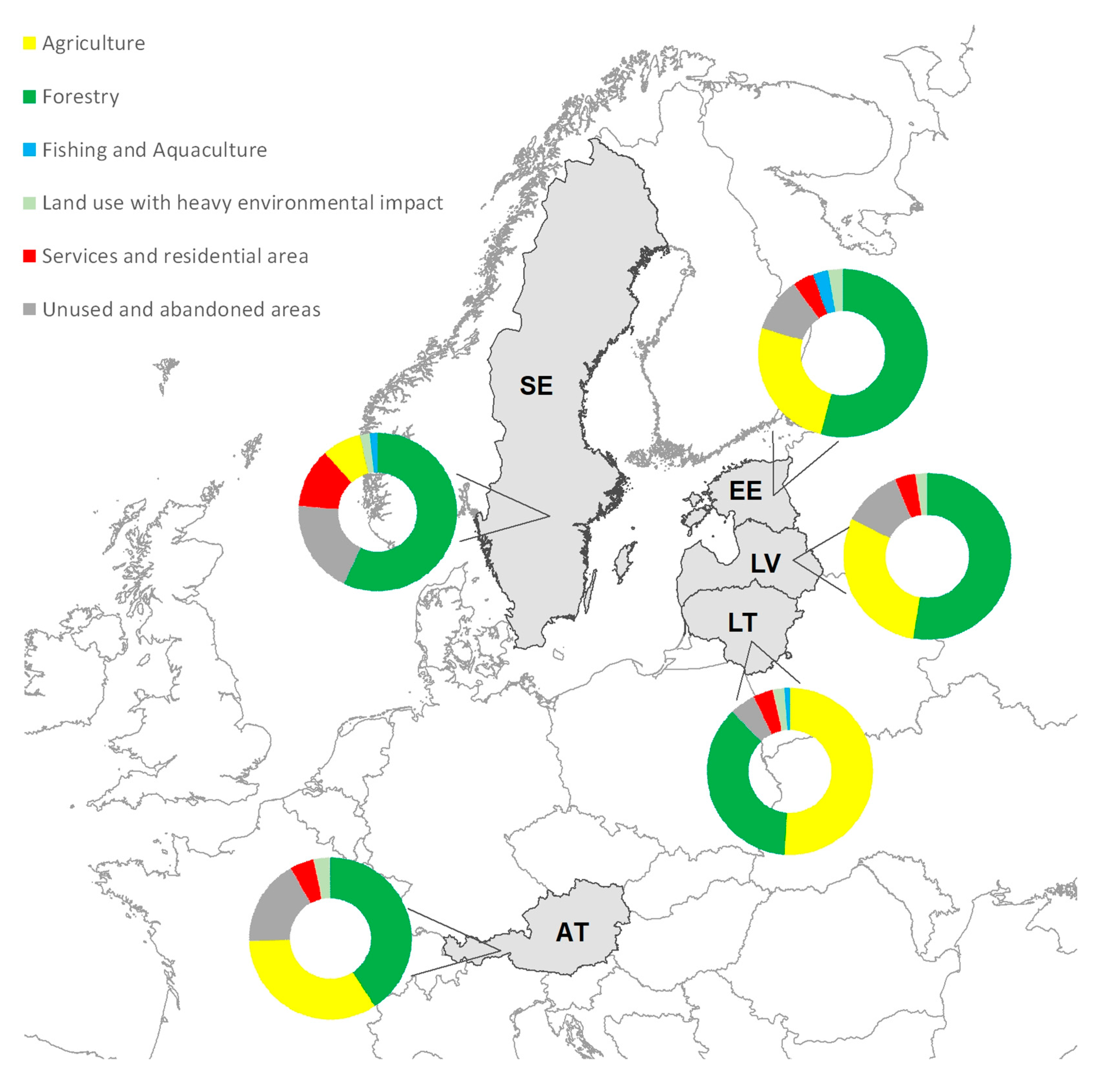
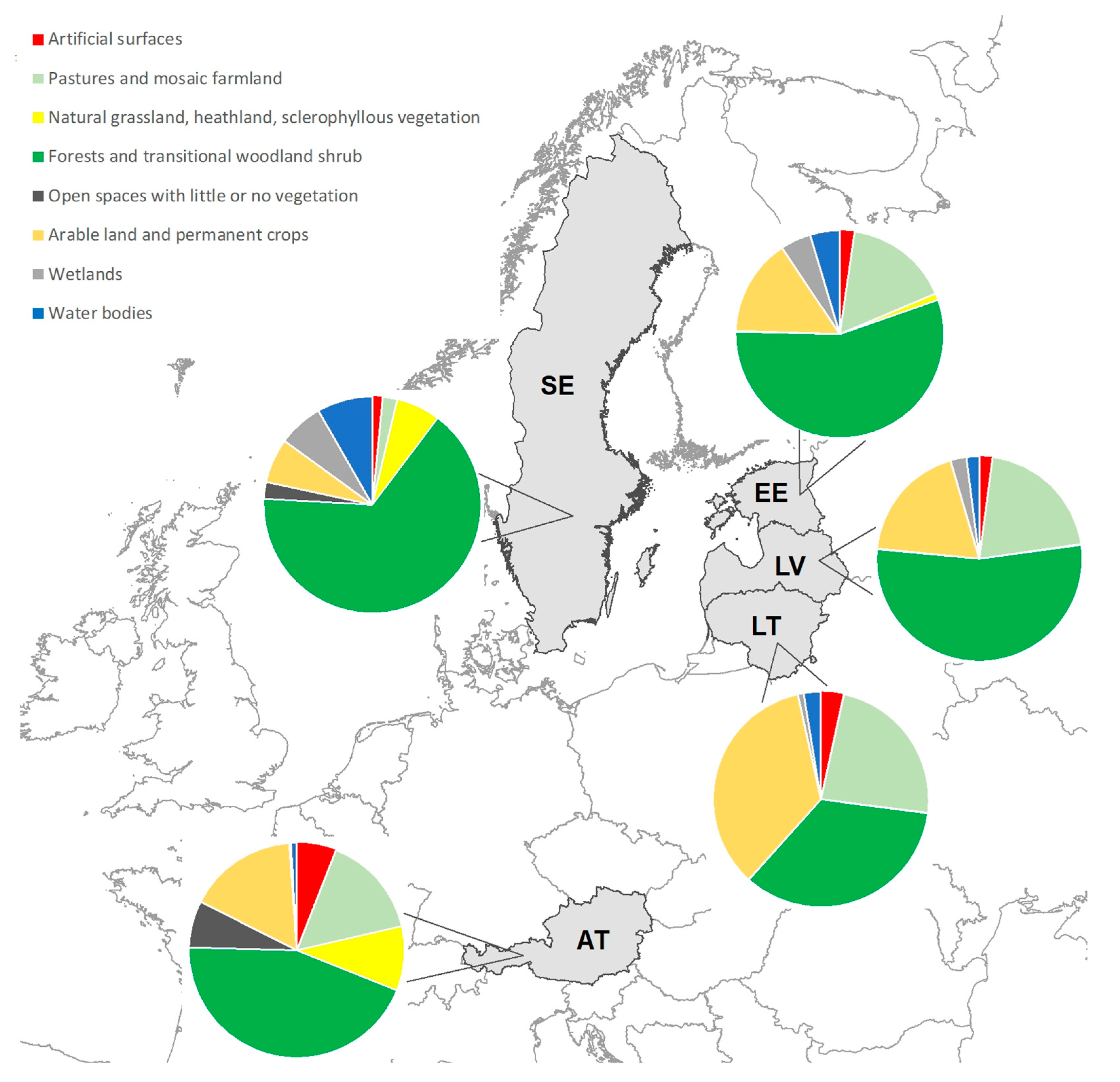