

Non-Invasive Archaeological Methodologies for the Analysis of the Port Structures of Portus Ilicitanus (Santa Pola, Alicante)

 , ,
, ,
Abstract
:1. Introduction
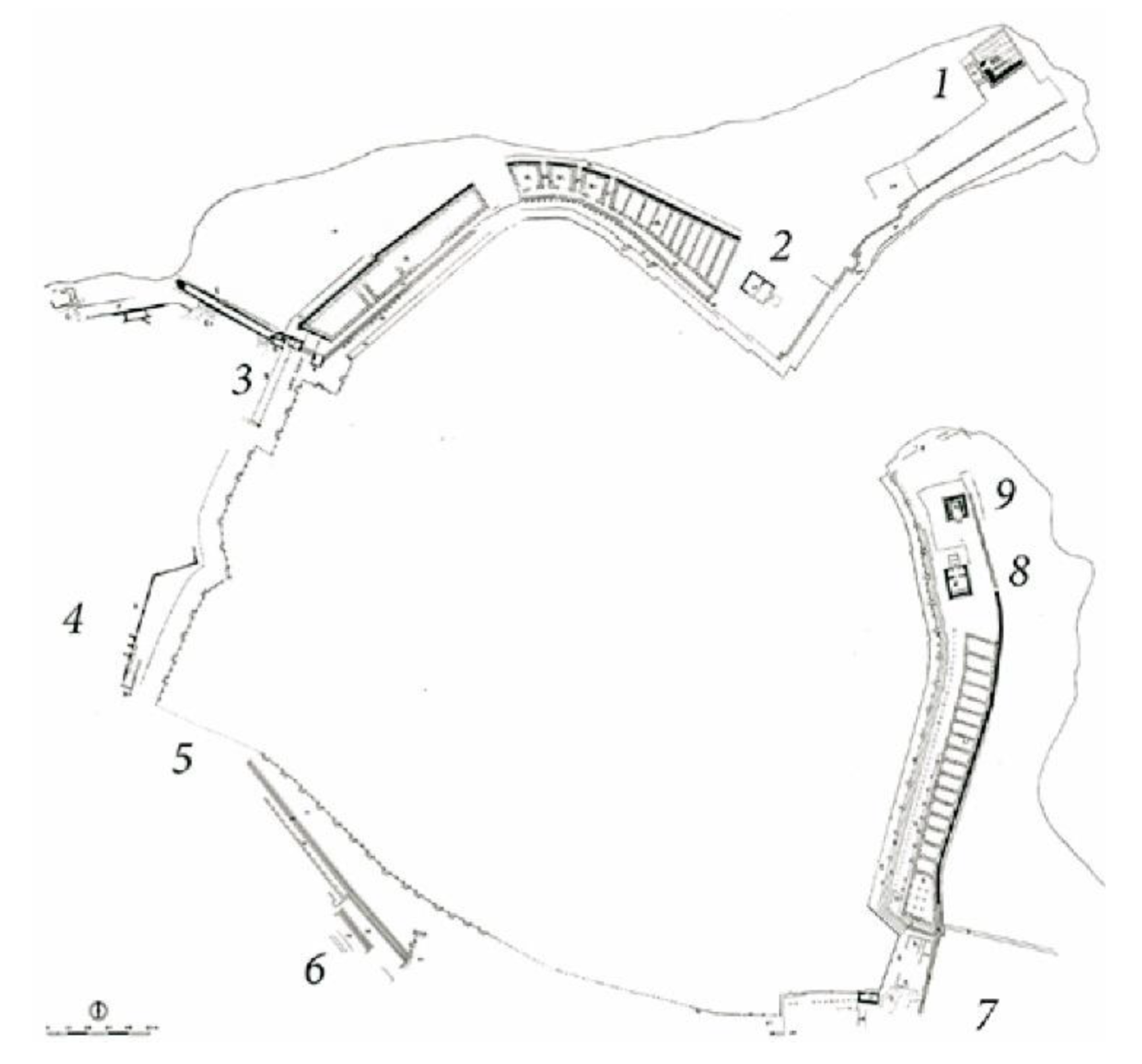
- Phase 0: fortress-settlement with empiric characteristics from the middle of the 5th century BC until the third quarter of the 4th century BC.
- Phase I: Foundation of the Portus Ilicitanus with possible domestic environments from the 2nd half of the 1st century BC and the Augustan period.
- Phase II: Housing structures and commercial warehouses from the 1st and 2nd centuries AD.
- Phase III: First phase of the cetaria from the second third of the 4th century AD.
- Phase IV: Extension of the cetaria from the last third of the 4th century AD.
- Phase V: Abandonment and amortisation of previous construction phases with the appearance of burials from the last third of the 4th century AD and the beginning of the 5th century AD.
2. Materials and Methods
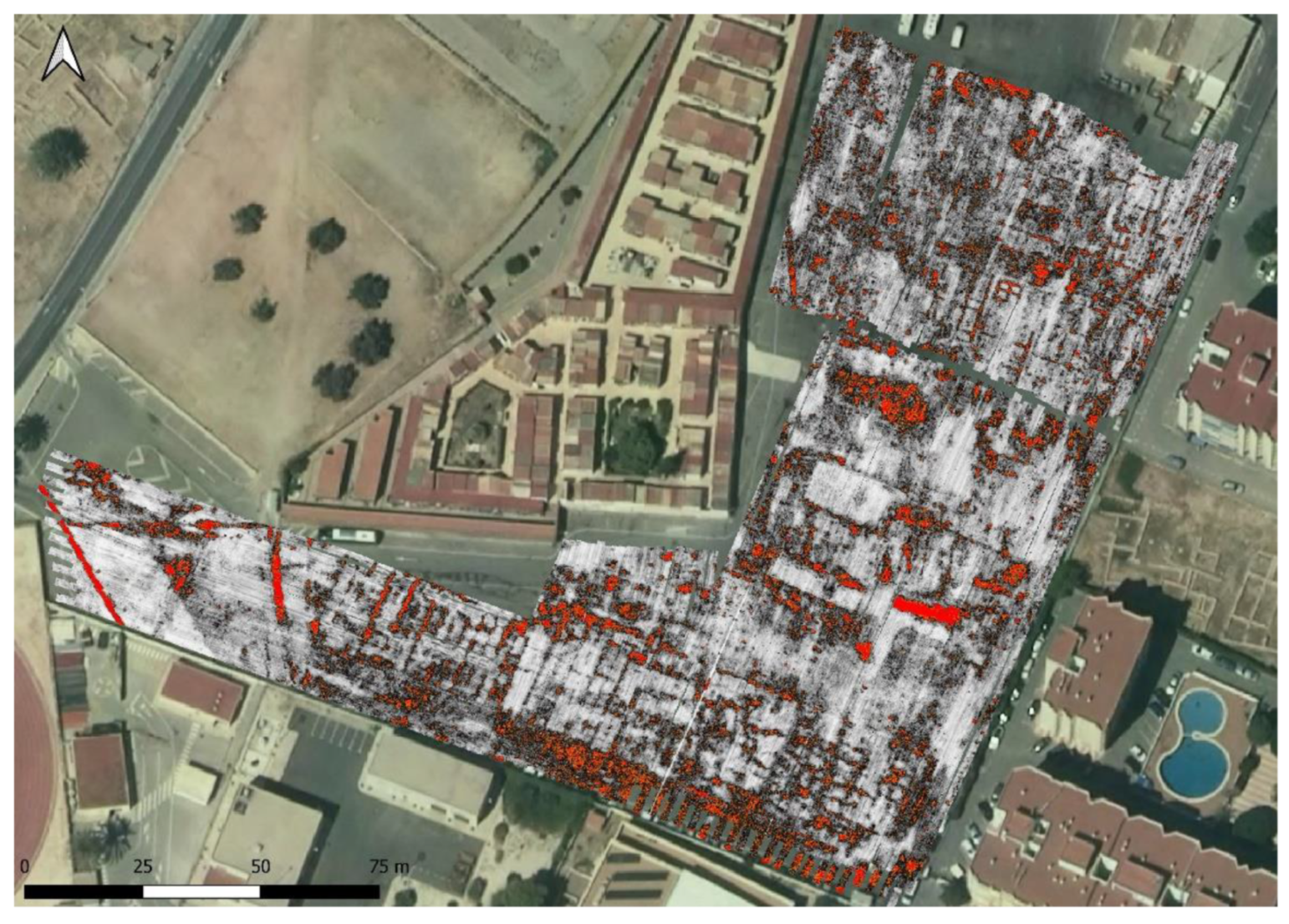
3. Results
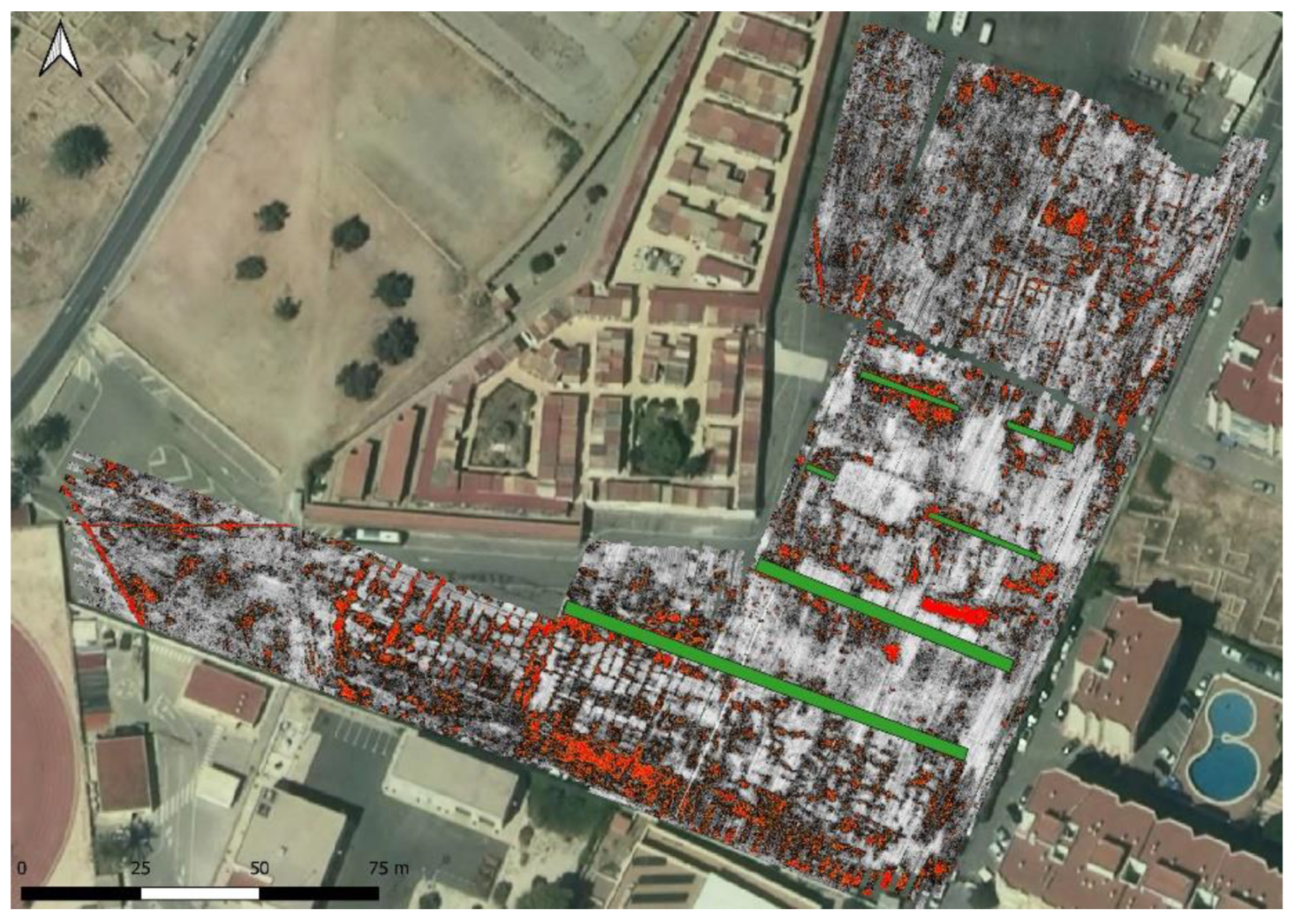
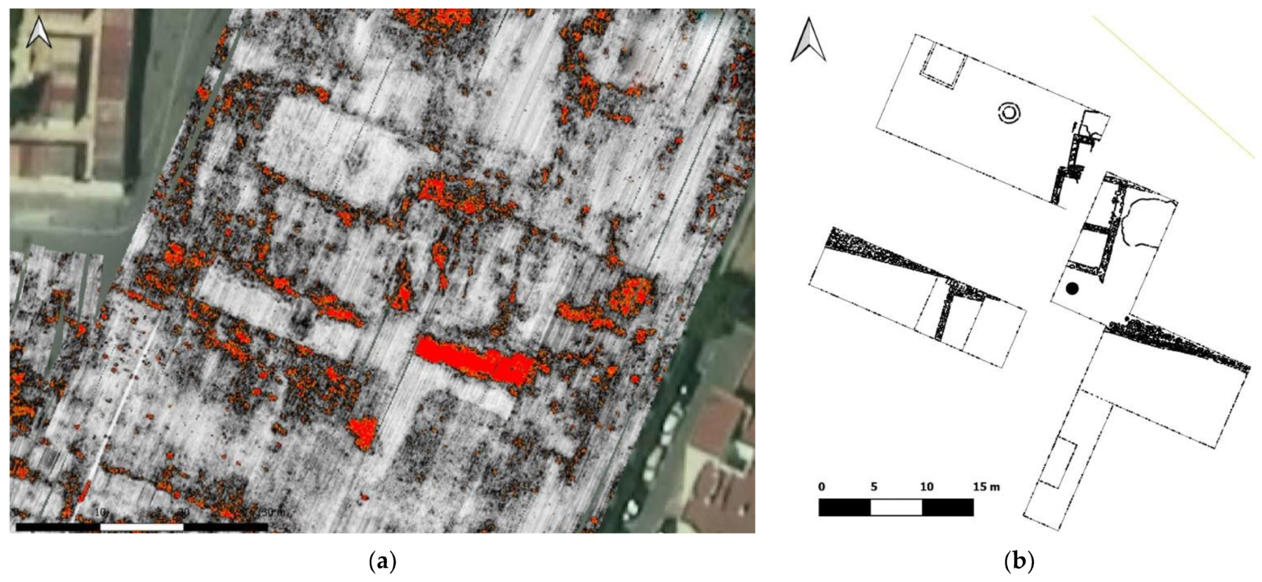
3.1. Set 1
3.2. Set 2
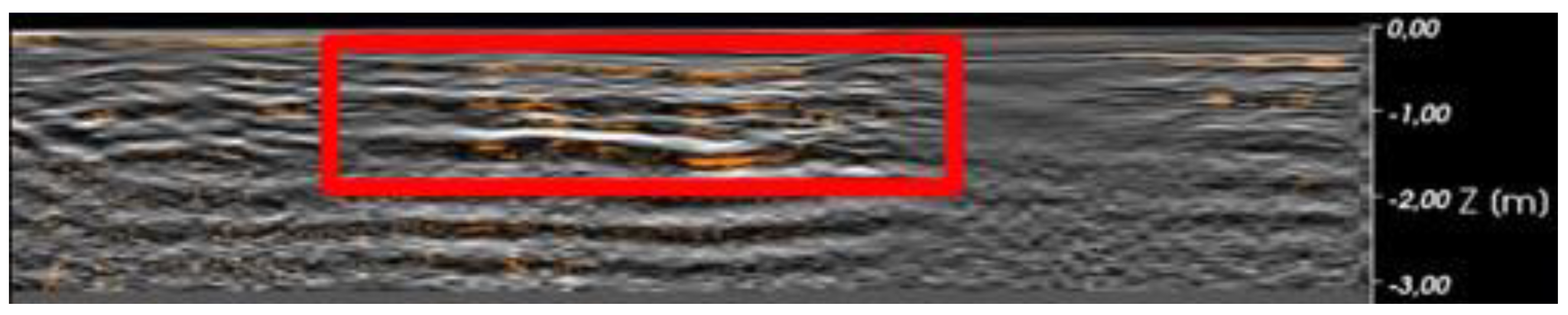
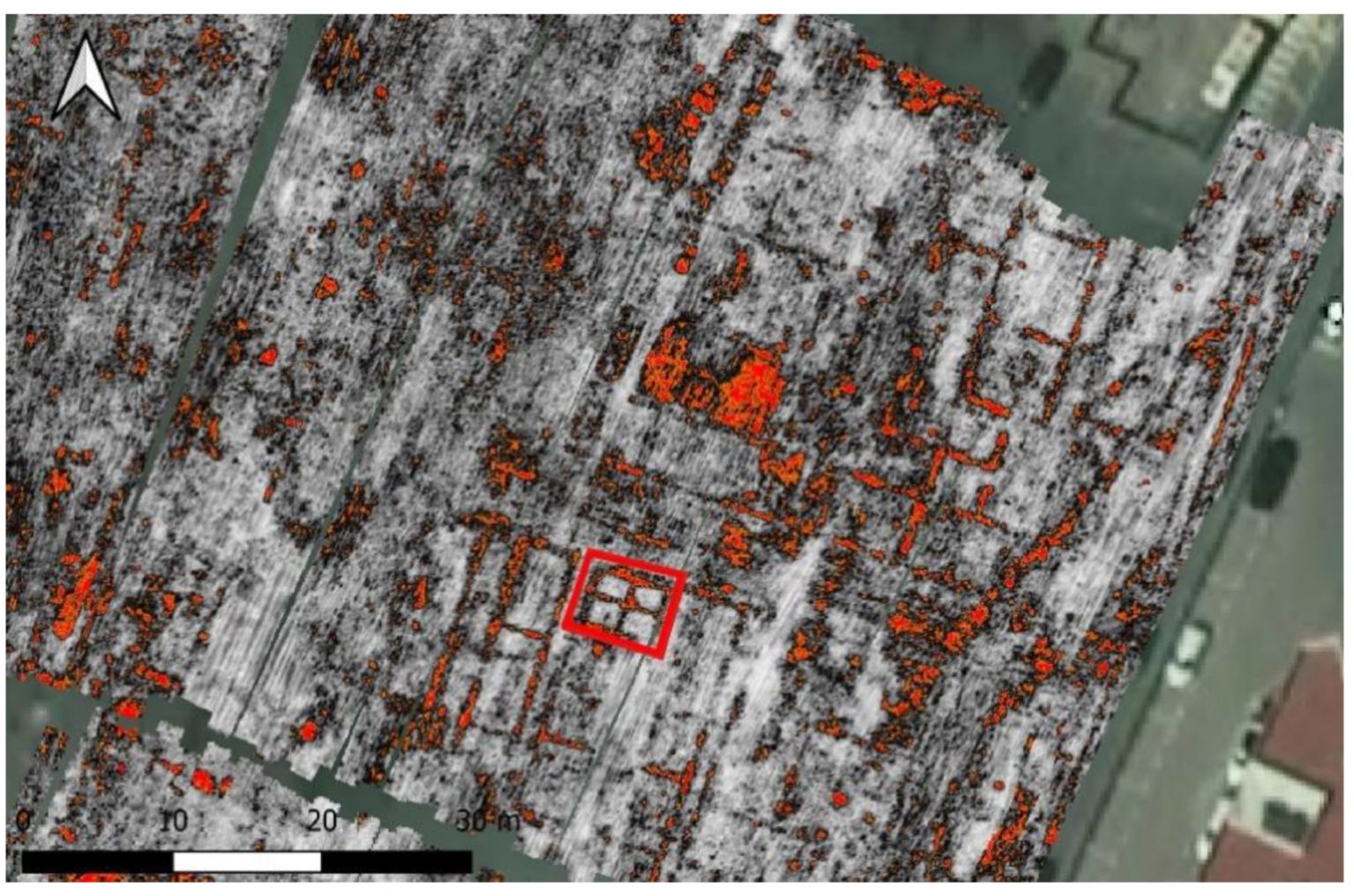
3.3. Set 3
3.4. Set 4
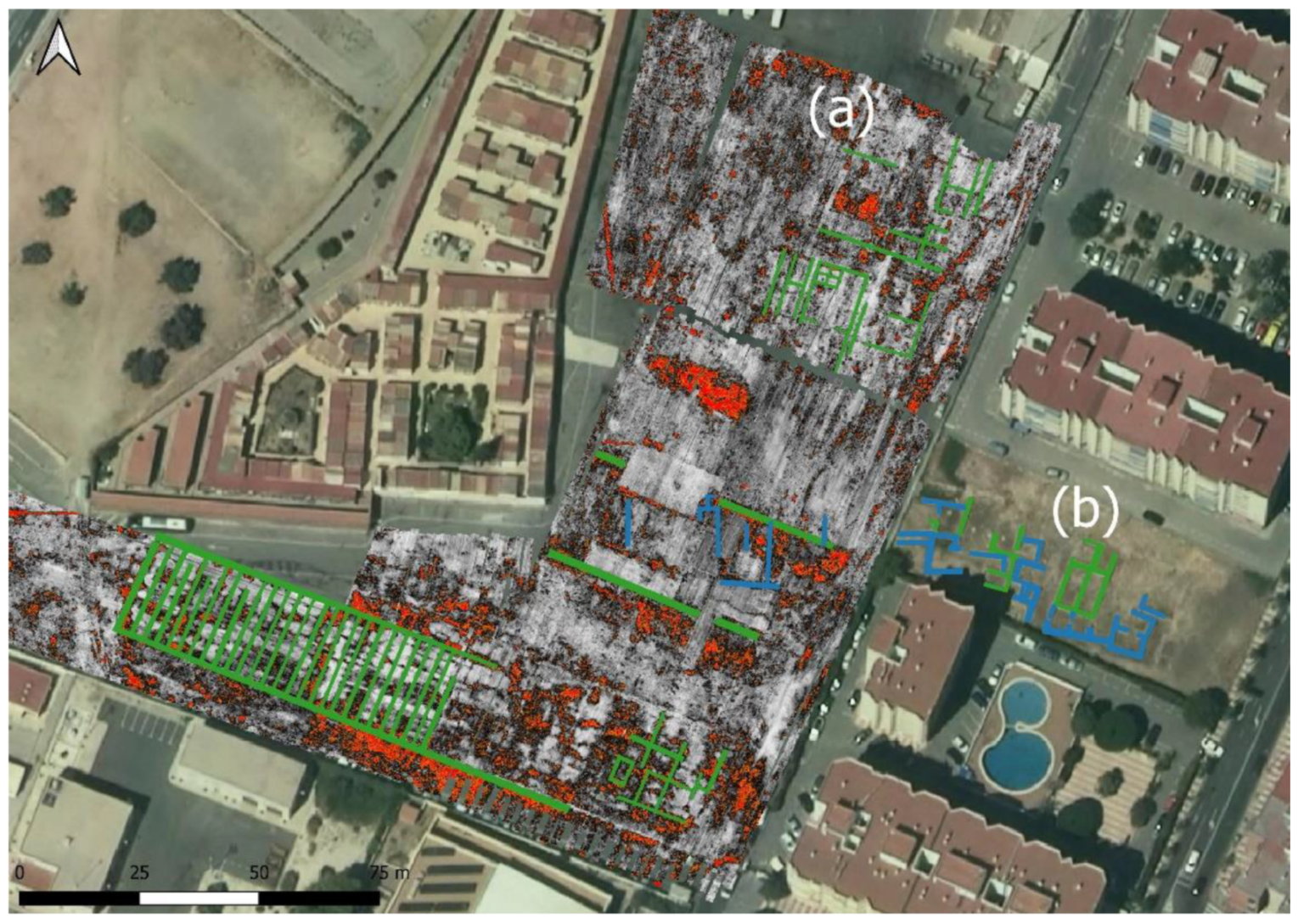
4. Discussion
5. Conclusions
Author Contributions
Funding
Data Availability Statement
Acknowledgments
Conflicts of Interest
References
- Moret, P.; Puigcerver, A.; Rouillard, P.; Sánchez, M.J.; Sillières, P. The fortified settlement of La Picola (Santa Pola, Alicante) and the Greek influence in South–east Spain. In Social Complexity and the Development of Towns of Iberia (Proceedings of the British Academy 86); Cunliffe, B., Keay, S., Eds.; The British Academy: London, UK, 1995; pp. 110–125. [Google Scholar]
- Badie, A.; Gailledrat, P.; Moret, P.; Rouillard, P.; Sánchez, M.J.; Sillières, P. Le Site Antique de La Picola à Santa Pola (Alicante, Espagne); Éditions Recherche sur les Civilisations Casa Velázquez: Paris, France, 2000. [Google Scholar]
- Alföldy, G. Administración, urbanización, instituciones, vida pública y orden social. In La Ciudad y los Campos de Alicante en Época Romana (Canelobre 48); Abascal Palazón, J.M., Abad Casanova, L., Eds.; Instituto de Cultura Juan Gil-Albert: Alicante, Spain, 2003; pp. 35–57. [Google Scholar]
- Abascal Palazón, J.M. Colonia Iulia Ilici Augusta. In Iberia, Hispania, Spania. Una Mirada desde Ilici; Abad Casal, L., Hernández Pérez, M.S., Eds.; CAM: Alicante, Spain, 2004; pp. 79–94. [Google Scholar]
- Sánchez, M.J.; Blasco Martínez, E.; Guardiola Martínez, A. Descubrimiento de una factoría bajoimperial de salazón de pescado en Santa Pola (Alicante). Saguntum 1989, 22, 413–438. [Google Scholar]
- Márquez Villora, J.C.; Molina Vidal, J.; Sánchez, M.J. La factoría de salazones del Portus Ilicitanus (Santa Pola, Alicante): Nuevos descubrimientos y estado de la cuestión. In Actas XXV Congreso Nacional de Arqueología. Valencia 1999 del 24 al 27 de Febrero; Diputación de Valencia: Valencia, Spain, 1999; pp. 360–364. [Google Scholar]
- Molina Vidal, J. La cetaria de Picola y la evolución del Portus Ilicitanus (Santa Pola, España). In III Congreso Internacional de Estudios Históricos. El Mediterráneo: La Cultura del Mar y la sal (Santa Pola, 24 al 27 de Octubre de 2004); Molina Vidal, J., Sánchez, M.J., Eds.; Ayuntamiento de Santa Pola: Santa Pola, Spain, 2005; pp. 110–145. [Google Scholar]
- Molina Vidal, J. El Portus Ilicitanus (Santa Pola, Alicante): Evolución y tráfico comercial en la época imperial. In Carta arqueológica subacuática de Alicante II. El Sinus Ilicitanus (Santa Pola/Tabarca-Pilar de la Horadada, Alicante). Siglos V a.C.–XIX d.C.; Azuar Ruiz, R., Inglese Carreras, O., Eds.; Diputación de Alicante: Alicante, Spain, 2022; pp. 93–112. [Google Scholar]
- Frías Castillejo, C.; Llidó López, F. Evolución de las actividades comerciales en la factoría de salazones de Picola–Portus Ilicitanus (Santa Pola, Alicante): Análisis numismático. In III Congreso Internacional de Estudios Históricos. El Mediterráneo: La Cultura del Mar y la sal (Santa Pola, 24 al 27 de Octubre de 2004); Molina Vidal, J., Sánchez, M.J., Eds.; Ayuntamiento de Santa Pola: Santa Pola, Spain, 2005; pp. 205–219. [Google Scholar]
- Márquez Villora, J.C. El Comercio Romano en el Portus Ilicitanus. El Abastecimiento Exterior de Productos Alimentarios (siglos I a.C.–V d.C.); Universidad de Alicante: Alicante, Spain, 1999. [Google Scholar]
- Álvarez Tortosa, J.F.; Bujalance Silva, R.; Mateo Corredor, D. Aproximación a la historia de un enclave portuario. El caso de Santa Pola (Alicante) desde la Antigüedad a la Alta Edad Media. In Comercio y Comunicaciones en el Corredor del Vinalopó. Patrimonio Histórico-Cultural del Vinalopó; Márquez Villora, J.C., Navalón García, R., Soler Milla, J.L., Eds.; Ayuntamiento de Elda: Elda, Spain, 2021; pp. 115–142. [Google Scholar]
- Mateo Corredor, D.; Álvarez Tortosa, J.F. Arqueología marítima del Portus Ilicitanus (Santa Pola). Evolución urbana y comercial en el contexto del Sinus Ilicitanus. Canelobre 2021, 72, 141–160. [Google Scholar]
- Sánchez, M.J.; Guardiola Martínez, A.; Blasco Martínez, E. Portvs Ilicitanvs: Excavaciones en la Casa Tardorromana de El Palmeral. Santa Pola (Alicante). Campaña de 1983; Generalitat Valenciana: Valencia, Spain, 1989. [Google Scholar]
- Sánchez, M.J. El puerto romano de Santa Pola. In Santa Pola. Arqueología y Museo; López Padilla, J.A., Ed.; Diputación de Alicante: Alicante, Spain, 2012; pp. 126–137. [Google Scholar]
- Busquier Corbí, J.D.; García Barrachina, A. Nuevas aportaciones para el estudio de la salazón en Santa Pola. In III Congreso Internacional de Estudios Históricos. El Mediterráneo: La Cultura del Mar y la sal (Santa Pola, 24 al 27 de Octubre de 2004); Molina Vidal, J., Sánchez, M.J., Eds.; Ayuntamiento de Santa Pola: Santa Pola, Spain, 2005; pp. 265–269. [Google Scholar]
- Ferrer, C.; Blázquez Morilla, A.M. Evolución geomorfológica del litoral del Baix Vinalopó y Baix Segura en época histórica. In Carta Arqueológica Subacuática de Alicante II. El Sinus Ilicitanus (Santa Pola/Tabarca-Pilar de la Horadada, Alicante). Siglos V a.C.–XIX d.C.; Azuar Ruiz, R., Inglese Carreras, O., Eds.; Diputación de Alicante: Alicante, Spain, 2022; pp. 43–64. [Google Scholar]
- Molina Vidal, J. La Dinámica Comercial Romana Entre Italia e Hispania Citerior; (ss. II a.C.–II d.C.); Universidad de Alicante: Alicante, Spain, 1997. [Google Scholar]
- Mateo Corredor, D. Comercio Anfórico y Relaciones Mercantiles en Hispania Ulterior; (ss. II a.C.–II d.C.) (Colección Instrumenta 52); Universidad de Barcelona: Barcelona, Spain, 2016. [Google Scholar]
- Matallana, F.F. Arquitectura portuaria romana en Carthago Nova. Novedades del frente marítimo en el solar de c/Mayor 23–25 de Cartagena. In XXIV Jornadas de Patrimonio Cultural. Región de Murcia 9, 16, 23 y 30 de Octubre de 2018; Tres Fronteras Ediciones: Murcia, Spain, 2018; pp. 357–362. [Google Scholar]
- Salido Domínguez, J.; Morais, R. El Horreum de la ciudad romana de Bracara Augusta (Braga, Portugal): Funcionalidad, tipología y contexto. Sautuola 2013, XVIII, 143–156. [Google Scholar]
- Martins, M. As Termas Romanas do Alto da Cividade. Bracara Augusta (Escavações Arquológicas 1); Unidade de Arqueologia da Universidade do Minho: Braga, Portugal, 2005. [Google Scholar]
- Aupert, P.; Dassié, J. L´urbanisme d´une agglomération secondaire: Nouvelles découvertes aériennes à Barzan. Aquitania 1997, 15, 167–186. [Google Scholar] [CrossRef]
- Laroche, C.; Savay-Guerraz, H. Saint-Romain-en-Gal. Un Quartier de Vienne Antique sur la Rive Droite du Rhône (Guides Archéologiques); Ministère de la Culture Impr. Nationale: Paris, France, 1984.
- Rickman, G. Roman Granaries and Store Buildings; University Press: Cambridge, UK, 1971. [Google Scholar]
- Bukowiecki, E.; Rousse, C. Ostia Antica: Entrepôts d’Ostie et de Portus. Les Grandi Horrea à Ostie. Mélanges L’ecole Française Rome 2007, 119, 283–286. [Google Scholar] [CrossRef]
- Rosamilia, E. Quando una città non parla del suo porto: Leptis Magna. In Il Mediterraneo e la Storia, III, Documentando Città Portuali—Documenting Port Cities; Institutum Romanum Finlandiae: Roma, Italy, 2021; pp. 265–289. [Google Scholar]
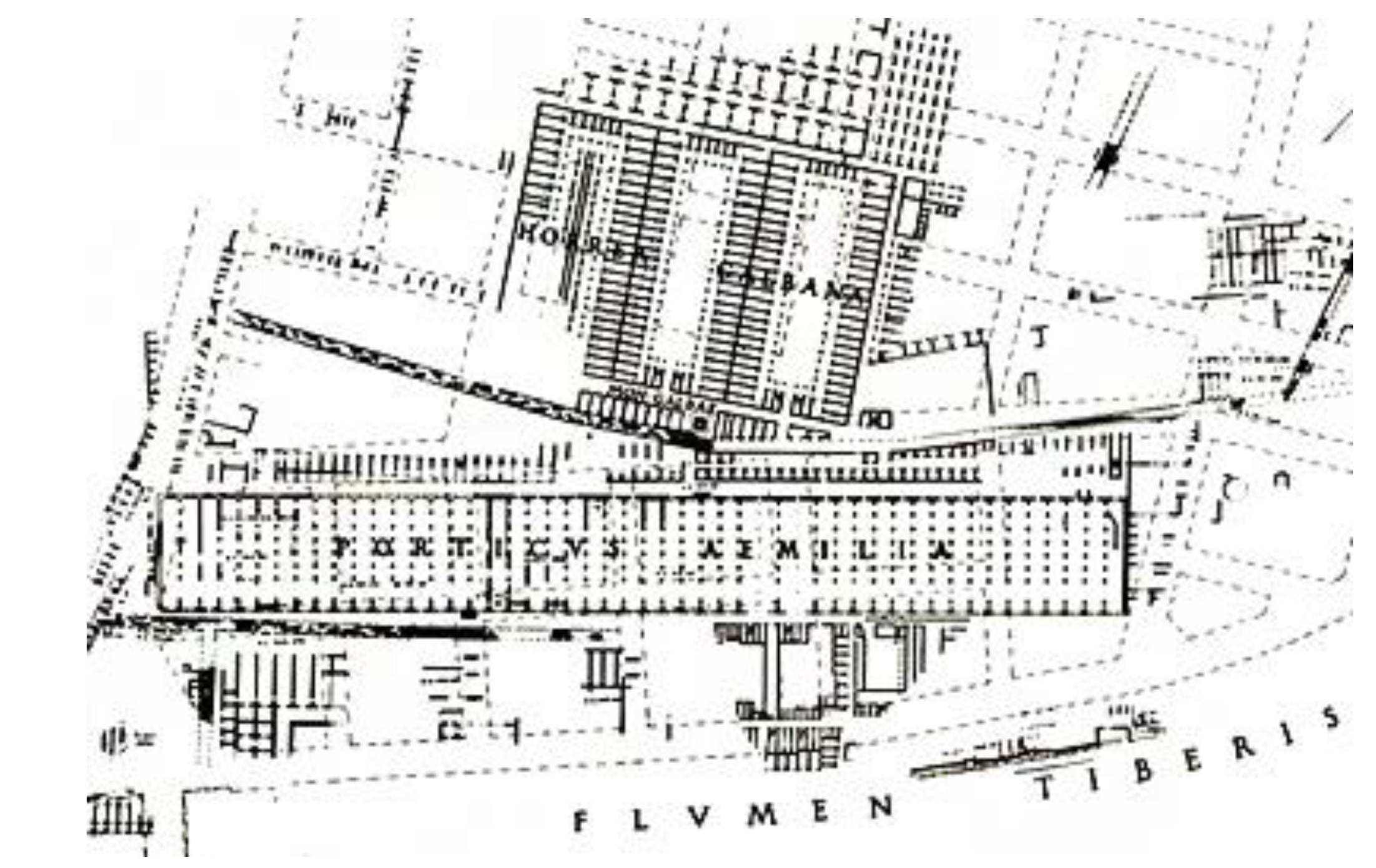
- Burgers, G.J.; Kok-Merlino, R.A.; Sebastiani, R. The Imperial horrea of the Porticus Aemilia. BABESCH 2015, 90, 199–212. [Google Scholar]
- Gatti, G. “Saepta Iulia” e “Porticus Aemilia” nella “Forma” Severiana. BullCom 1935, 62, 135–144. [Google Scholar]
- Luigi, G.; Filibeck, G. Il porto di Roma Imperiale e L’agro Portuense; Officine dell’Istituto Italiano d’Arti Grafiche: Roma, Italy, 1935. [Google Scholar]
- Keay, S.; Millett, M.; Paroli, L.; Strutt, K. Portus. An Archaeological Survey of the Port of Imperial Rome 1998–2001; British School at Rome: London, UK, 2005. [Google Scholar]
- Keay, S. (Ed.) Rome, Portus and the Mediterranean; British School at Rome: London, UK, 2012. [Google Scholar]
- Salido Domínguez, J.; Neira Jiménez, M.L. Representaciones de “horrea” en la musivaria romana. Problemas para su identificación. Lvcentvm 2014, 33, 201–214. [Google Scholar] [CrossRef] [Green Version]
- Barbet, A. Une peinture de bassin dans la maison des nymphes à Nabeul. Ses relations avec les mosaïques. In La Mosaïque Greco-Romaine VII; Ennaïfer, M., Rebourg, A., Eds.; Institut National du Patrimoine: Tunis, Tunisia, 1999; Volume 1, pp. 311–319. [Google Scholar]
- Dunbabin, K.M.D. The Mosaics of Roman North Africa; Clarendon Press: Oxford, UK, 1978. [Google Scholar]
- Blázquez, J.M. Mosaicos Romanos de la Real Academia de la Historia. Ciudad Real, Toledo, Madrid y Cuenca (CME V); CSIC: Madrid, Spain, 1982. [Google Scholar]
- Balil, A. Monumentos alejandrinos y paisajes egipcios en un mosaico romano de Toledo (España). In Studi in Onore di Achille Adriani; Bonacasa, N., Di Vita, A., Eds.; L’Erma di Bretschneider: Roma, Italy, 1984; Volume 3, pp. 433–439. [Google Scholar]
- Neira Jiménez, M.L. Sobre la representación de ciudades marítimas en mosaicos romanos. Espacio. Tiempo y Forma. Serie II. Historia Antigua 1997, 10, 219–251. [Google Scholar] [CrossRef]
- Gasparri, C. Due mosaici antichi in S. Maria in Trastevere. In Alessandria e il Mondo Ellenistico-Romano: Studi in Onore di Achille Adriani; Bonacasa, N., Di Vita, A., Eds.; L’Erma di Bretschneider: Roma, Italy, 1983–1984; pp. 672–676. [Google Scholar]
- Ferdi, S. Mosaïque des Eaux en Algérie. Un Langage Mythologique des Pierres; RSM Communication: Argel, Algeria, 1998. [Google Scholar]
- Boulinguez, C.; Napoli, J. Hippone, port de l’annone: La contribution de l’iconographie. In Africa Romana XVII. Le Ricchezze dell’Africa. Risorse, Produzioni, Scambi; González, J., Ruggeri, P., Vismara, C., Zucca, R., Eds.; Carocci Editore: Roma, Italy, 2008; pp. 703–730. [Google Scholar]
- Aurigemma, S. L´Italia in Africa. I Mosaici; Istituto Poligrafico Dello Stato: Roma, Italy, 1960. [Google Scholar]
- Arquealia. Excavación arqueológica en el Centro de las Artes (Santa Pola). In Informe Arqueológico (Expte. 2003/0689-A); Arquealia: Santa Pola, Spain, 2004. [Google Scholar]


Publisher’s Note: MDPI stays neutral with regard to jurisdictional claims in published maps and institutional affiliations. |
© 2022 by the authors. Licensee MDPI, Basel, Switzerland. This article is an open access article distributed under the terms and conditions of the Creative Commons Attribution (CC BY) license (https://creativecommons.org/licenses/by/4.0/).
Share and Cite
Álvarez Tortosa, J.F.; Catalán González, F.J.; Mateo Corredor, D.; Ruiz Barroso, M.; Molina Vidal, J. Non-Invasive Archaeological Methodologies for the Analysis of the Port Structures of Portus Ilicitanus (Santa Pola, Alicante). Land 2022, 11, 2159. https://doi.org/10.3390/land11122159
Álvarez Tortosa JF, Catalán González FJ, Mateo Corredor D, Ruiz Barroso M, Molina Vidal J. Non-Invasive Archaeological Methodologies for the Analysis of the Port Structures of Portus Ilicitanus (Santa Pola, Alicante). Land. 2022; 11(12):2159. https://doi.org/10.3390/land11122159
Chicago/Turabian StyleÁlvarez Tortosa, Juan Francisco, Francisco Javier Catalán González, Daniel Mateo Corredor, Manuel Ruiz Barroso, and Jaime Molina Vidal. 2022. "Non-Invasive Archaeological Methodologies for the Analysis of the Port Structures of Portus Ilicitanus (Santa Pola, Alicante)" Land 11, no. 12: 2159. https://doi.org/10.3390/land11122159