

The Hornsby Quarry Geosite, NSW, Australia—A Geoheritage Treasure
Western Sydney University, The College, Quakers Hill, NSW 2763, Australia
Land 2022, 11(12), 2124; https://doi.org/10.3390/land11122124
Submission received: 29 October 2022
/
Revised: 20 November 2022
/
Accepted: 21 November 2022
/
Published: 25 November 2022
(This article belongs to the Special Issue Geoparks, Geotrails, and Geotourism – Linking Geology, Geoheritage, and Geoeducation)
Abstract
:Quarrying for aggregate material at Hornsby in New South Wales (Australia) exposed a >100 m-deep cross-section of the volcanic neck of a Jurassic diatreme, which extruded through the Sydney Basin deposits. The cross-section reveals volcanic features at many scales. Globally, there are very few instances of such excellent 3D exposure. It is arguable that this exposure alone makes it a geosite of international value. However, evaluation of the Hornsby Diatreme using a geoheritage toolkit shows that it meets various geoheritage conservation criteria, being a reference site, and an historically and culturally important site, as well as hosting important archival material. It has significant features at various scales: at the macroscale, where dish beds are visible on all quarry walls, preserving the structure formed during volcanic accretion and later caldera collapse; at the mesoscale, where breccia and surge layers are visible, providing insight into how magma interacted with various host rock types; and at the microscale, where lapilli, chilled margins on host rock blocks, and carbon-rich xenoliths are visible in hand specimens. As such, the Hornsby Quarry hosts a world-class array of volcanic features and preserves an important period of volcanic and post-volcanic history within the Sydney Basin, fostering geoeducation and geotourism.
1. Introduction
The aim of this paper is to describe the salient macro- to microscale geological features of the Hornsby Diatreme, to evaluate the volcanic products and processes they preserve, and to determine the significance of its geoheritage features with respect to other diatremes in Australia and worldwide.
Before these steps are undertaken, it is important to establish the relevance of diatremes in general, and the relevance of the quarry and the Hornsby Diatreme in particular.
1.1. The Nature of Diatremes
Volcanoes are one of the most complicated geological systems on Earth because molten rock, fluids, and gases interact with the subsurface geological and hydrological systems. A diatreme (which is essentially the former feeder pipe of a volcano) represents one aspect of these complex systems. Diatremes form as igneous material explosively intrudes into country rock via a pipe conduit and produces a maar crater and tephra ring at the surface; its subsequent collapse forms a volcanic neck in the subsurface and a caldera at the surface.
Many diatremes are known solely from their surface expressions, identified by remnant maars or calderas. These surface expressions, maars and calderas, are known from many localities worldwide (e.g., Devil Mountain Lakes of Alaska, Kilbourne Hole of New Mexico). In contrast, their subsurface features are known only where they have been quarried, exposed in cliff sections, or exposed as buttes, e.g., Black Butte (Missouri River Breaks). The subsurface features of diatremes in their upper and lower levels are less known, but nonetheless are actively studied because they provide clues to the upper mantle and mantle materials and processes. According to the accepted model of Lorenz [1], refined in Lorenz and Kurszlaukis [2], diatremes are characterized by dish beds and volcanic breccias in their upper layers; and weak basinal layering and dikes in their lower layers.
Diatremes (and their associated maars and calderas) have various expressions, depending on the type of magma involved in their development (felsic, mafic, or ultramafic), and their subsequent post-volcanic history (single or multiple explosive events; impacted by collapse and subsidence). Their maars or calderas may be filled with post-volcanism sediments (e.g., Wau in Papua New Guinea [3]) or by lakes (e.g., Trans-Mexican Volcanic Belt [3]), or may be weathered out to expose deeper levels of the diatreme (e.g., Missouri River Breaks volcanic field [4]). World-class examples, where the subsurface features are visible, include the tuff pipes of SW Germany [5] and the volcanic necks of East Fife in Scotland [6]. As such, there is no single diatreme that can fully represent their entire geological nature and complexity. Thus, the significance of a diatreme must be evaluated with regard to the type of magma, its subsequent history and the nature of its exposure, the diversity of its features, and its geological setting.
In the Sydney Basin of New South Wales (NSW), Australia, around 150 mafic diatremes were recorded or inferred from topography, drill samples, or aerial photography [7,8]; they are related to Jurassic volcanic events. The largest, best exposed (exposing its upper layers), and relatively unweathered example of diatremes of this suite, occurs at Hornsby (Figure 1). This diatreme is composed of a long vertical pipe or plug of basalt. Its basaltic core is surrounded by volcanic breccia, containing coal, sandstone, and shale lithic fragments, as well as rarer ultrabasic xenoliths and lapilli in a tuffaceous matrix.
Most of the other Jurassic diatremes in the Sydney Basin have been subsequently mined and infilled, because of the importance of volcanic rocks as road bases and aggregate materials for construction. For example, access to Minchinbury and Erskine Park, where diatremes were formerly studied in the Sydney Basin, is no longer possible because these quarries were infilled and landscaped. Hence, the Hornsby site is now unique, representing one of the last Jurassic diatremes in the Sydney Basin.
1.2. The History of the Quarry
In 1905, the Higgins family, who received the Hornsby Valley as a land grant, began quarrying the diatreme for blue metal (basalt) as gravel aggregate. In 1912, the quarry was purchased by the Hornsby Shire Council, which realized the importance of the local volcanic material for constructing and maintaining the local road networks. Given the high demand for road base, the Hornsby Diatreme was mined for aggregate material by various enterprises from the early 1900s until the late 1990s, including the Hornsby Shire Council (1912–1924), Hornsby Blue Metal Limited (1924–1932), Farley and Lewers (1959–1980), and CSR Construction Materials (1981–2002). Such extensive quarrying of volcanic material, at times involving extraction of 200,000 tonnes per annum, exposed the subsurface features of the volcanic neck to a depth of around 120 m.
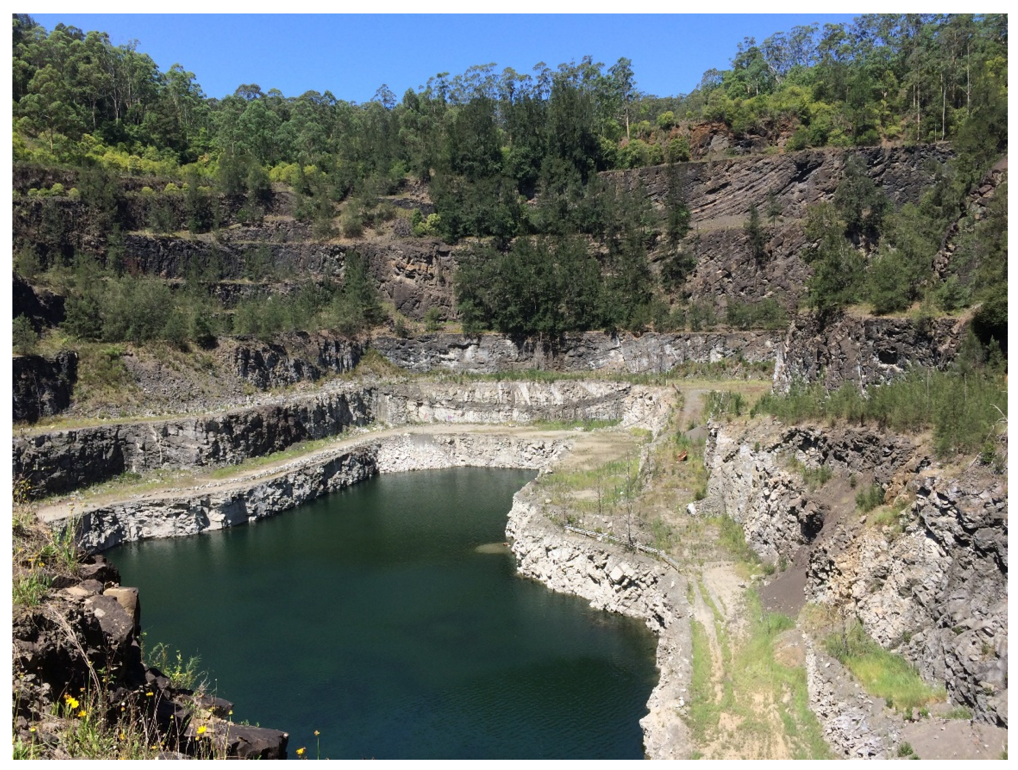
After quarry operations ceased, the site was purchased by the local council. Due to the fact the site was geotechnically unstable, public access was extremely limited. In early 2016, the quarry was an oval-shaped depression, measuring around 300 m × 200 m. The quarry sides were terraced, and the base of the depression contained water from natural run-off and rain. A 3D panorama of geology could be seen within the quarry, and it was possible to trace dish beds around the quarry walls. At this time, access was granted under the conditions of carrying out an archival photographic recording of its geological features. In late 2016, the quarry was partially filled by tunnel spoil from local roadworks.
1.3. The Historical and Geoheritage Value of the Quarry and Diatreme
The Sydney Basin, one of eleven geological terranes in NSW (Figure 1), comprises mostly Triassic material, which was later intruded by Jurassic igneous rocks and diatremes. Most of these diatremes were mined for aggregate material, e.g., Erskine Park, Minchinbury Quarry, Dundas Quarry, Marsden Park, and were later completely or partially infilled, although earlier references described volcanic features at these sites [7,8,11]. In 2016, the Hornsby Diatreme was the largest and best exposed remaining example of a diatreme in the Sydney Basin.
The Hornsby Quarry was recognized as having geoheritage and educational value at the turn of the century by early geologists, who identified it as a large volcanic feature, e.g., early mapping in 1903 [12] and petrological studies in 1911 [13]. The Hornsby Valley/Quarry site was listed in the comprehensive geological excursion guide for the Sydney Basin by Branagan and Packham [9,10] because of its unique exposure of the upper levels of a diatreme and its clearly exposed and unweathered volcanic and host rocks. Its teaching and research potential led it to being one of earliest geological sites, listed on the now defunct Register of National Estate; it was registered as a natural item (no. 2613) on 1 November 1983 (https://www.dcceew.gov.au/parks-heritage/heritage/places/register-national-estate; accessed on 29 October 2022).
The geoheritage significance of the Hornsby Diatreme was reaffirmed by Percival [14], describing geoheritage sites of NSW, who stated that “the Hornsby diatreme is the largest example of this phenomenon, and also the best exposed in the Sydney area”.
In 2013, the Hornsby Diatreme was listed on the Hornsby Local Environmental Plan [15] as an item of environmental and archaeological heritage.
2. Materials and Methods
To assess the geoheritage significance of the Hornsby Quarry, it was necessary to:
- document its macro- to microscale geological features
- evaluate the products and processes it preserves
- evaluate the level of significance of its geoheritage features.
A catalogue of volcanic features and evaluation of the products and processes that they preserve was compiled based on detailed site observations and an extensive literature review of publications on diatremes within the Sydney Basin.
The geological features of the site were assessed as to their geoheritage significance using the framework provided by the Geoheritage Tool-kit of Brocx and Semeniuk [16], as applied in various case studies [17,18].
The steps undertaken for the comparison and evaluation of the Hornsby Diatreme are provided in Table 1.
3. Results
The diatreme exposed in the Hornsby Quarry is principally composed of volcanic breccia and, in outcrop, is largely hosted by Triassic sandstones of the Sydney Basin. At lower depths, it traverses Permian shales and coals. Being a product of an explosive extrusion, the diatreme has a large variety of important volcanic features, including a saucer-shaped overall structure (dark grey volcanoclastic breccia forming the diatreme layers), surge deposits, accretionary lapilli, rock lenses, and xenolith fragments of granite, gabbro and peridotite, basalt, breccia (including intrusive breccia), shales and siltstones, pebbles, sandstones, coal fragments. The location of these features at the Hornsby Quarry in relation to eastern, western, northern, and southern faces of the quarry is summarized in Table 2. Several macro- to micro-scale features are shown in Figure 2, Figure 3 and Figure 4.
4. Discussion
4.1. Assessment of the Hornsby Quarry Using the Geoheritage Tool-Kit
To classify the geoheritage features and assess the geoheritage values of the Hornsby Quarry, the Geoheritage Tool-Kit of Brocx and Semeniuk [16,17,18] was applied. This tool-kit classifies sites of geoheritage significance into four conceptual categories of geoheritage in (A), determines the scales of these geological features in (B), and determines various levels of significance in (C). Using this framework, Table 3 shows that the Hornsby Quarry with exposure of the Hornsby Diatreme represents three of these categories of geoheritage, with geological features at multiple scales, having local to international levels of significance (stars within the Table cells indicate all categories that apply to the Hornsby Quarry site within this framework; modified from figures used in an earlier study evaluating geoheritage sites in NSW [19]).
4.2. A: Conceptual Categories of Geoheritage Significance Relevant to Hornsby Quarry
4.2.1. Type Example, Reference Site
Hornsby Quarry is clearly a geological reference site for the State of NSW. It cross-cuts one of the largest diatremes known in the Sydney Basin, exposing its upper layers in cross-section. Although diatremes were once relatively common in the Sydney Basin, the Hornsby Quarry is now the only site where geological structures can be examined in situ, and unweathered material can be collected for study.
There are several features at the Hornsby Quarry, spanning outcrop to hand-specimen scale, that provide outstanding examples of volcanic features of diatremes. These include dish beds, breccia layers, accretionary lapilli, and a multiplicity of xenoliths.
A global review of maars and related volcanic features by White and Ross [20], carried out in 2011, indicates that there are no comparable exposures of dish beds and breccia layers worldwide, making this site internationally unique as a reference site.
4.2.2. Historically Significant Geological Site
The Hornsby Diatreme has value as a historical geological study site, being relevant to the history of the study of geology in Australia, and to the volcanic history of eastern Australia. It was first identified as a volcanic feature and mapped in the early twentieth century by Pittman [12]. At that time, the lack of exposure and access to unweathered material meant that early studies were mainly petrological in nature, e.g., Benson’s work [13].
Because of its volcanic materials, it became one of the largest blue metal quarries locally and provided a road base for the Hornsby Shire and other local councils to develop and maintain their road networks. The high demand for aggregate material resulted in almost continuous operation from 1905 until 2003. Extraction of aggregate and blue metal (basalt) led to the exposure of the volcanic neck and to unweathered volcanic materials.
As quarrying progressed, studies began to focus on the internal structure and the unweathered volcanic and host rock materials of the diatreme, which showed unusual volcanic-host rock interactions (e.g., Wilshire’s work [11]). When fresh palynological material was collected and dated by Helby and Morgan [21], this proved to be crucial to understanding and dating the volcanic events forming part of the geological history of the Sydney Basin.
4.2.3. Geohistorical Site
In addition to its excellent exposure of the structural features of a diatreme, the Hornsby Quarry provides access to an archive of unweathered volcanic rocks (basalt), crustal and mantle xenoliths (peridotite), and host rocks containing well-preserved microfloral fossils of Jurassic age. Access to fresh material at this site has provided important insights into diatremes and the volcanic history of the Sydney Basin. Structural and petrological studies of the site have even led to a new genetic interpretation of the saucer bedding [23]. Meanwhile, its ultramafic xenoliths provide unique information about the lower crustal conditions below the Sydney Basin.
Prior to its closure, Hornsby Quarry was used as a university field site for geology and civil engineering students, being the only locality in the Sydney Basin, where it is possible to examine and document the internal structures of a diatreme in 3D and to collect relatively unweathered material for study.
The host rocks contain well-preserved microfloral fossils of Jurassic age. It is the only site in the Sydney Basin, where pollen, coal, and wood fragments from layered coal lithoclasts within the breccia layers of the diatreme were successfully dated, providing a Jurassic age (146–200 million years ago) for its intrusion into the Sydney Basin [21]. The dating of fossil pollen identified the only sedimentary material of this age in the Sydney Basin.
The presence of fossil pollen and the availability of fresh volcanic and sedimentary material at Hornsby Quarry make this site nationally important as an archival site providing key information on ancient sequences of the Sydney Basin.
4.3. B: Scales of Geoheritage Features Relevant to Hornsby Quarry
In terms of scale, the site encompasses volcanic features characteristic of a diatreme, from macro- to microscale, or from outcrop to crystal scale:
- at outcrop scale: important features include the geometry of diatreme, dish beds, sand dikes, and breccia layers
- at bedding scale: important features include breccia beds, surge layers, bombs
- at crystal scale: important features include chilled margins, lithic fragments, carbonate veining, and accretionary lapilli.
At the macroscale, one of the most important features of the quarry is its dish beds. These dish beds were likely formed due to subsidence or post-eruption collapse of the caldera and are characteristic of upper sections of diatremes worldwide. The Hornsby Quarry exposes outstanding dish beds in cross-section.
At the mesoscale (or bed-scale), the Hornsby Diatreme has abundant volcanic breccia layers, comprising fragments of basalt as well as host rock fragments of shale, sandstone, conglomerate, coal and rarer ultramafic xenoliths. Calcite veins cut through some of these breccia layers, recording hydrothermal post-volcanic processes. The breccia layers and bombs are characteristic of diatremes and provide important clues to the volcanic processes involved in their explosive emplacement and to the nature of the crust below the volcanic neck. Breccia layers are visible in all quarry faces.
At the microscale, pea-sized ejecta (i.e., known as accretionary lapilli) are found within the quarry. These lapilli are characteristic of explosive eruptions, being formed by the interaction of ash and moisture [24]. They are an important small-scale feature of maar volcanos and can be preserved in diatremes within breccia blocks.
At the crystal scale, the petrology of reaction rims around host rock fragments and ultramafic xenoliths within these breccia layers can have unusual mineral associations, e.g., rare pyroxene chromite xenoliths described by Benson [13] and Wilshire [11] from the Dundas volcanic neck.
Using the criteria of the Geoheritage Tool-Kit [16,18], the Hornsby Quarry exhibits a large range and array of volcanic features. Some of these features are of international standing, given the exposure of material at the outcrop scale. Others are of National to State levels of significance, recording and preserving processes at the outcrop scale (intrusion and host rock brecciation of Sydney Basin deposits during volcanism) to the crystal scale (lapilli formation and chilled margins to lithic fragments related to explosive intrusion of the diatreme) related to an important volcanic period within the Sydney Basin.
4.4. C: Levels of Significance of Geoheritage Features at Hornsby Quarry
To evaluate the significance of its various geoheritage features, the Hornsby Quarry was compared and contrasted with other sites, locally, nationally, and internationally, based on available literature (Table 4). The sites selected to provide a context to the Hornsby Diatreme’s significance are those that provide some exposure to the subsurface features of a diatreme and not only its surface features (maars). The Table also illustrates the diverse and complex nature of diatremes worldwide and which ones have conservation status.
It has already been established that the Hornsby Quarry is the best and only remaining example of a diatreme within the Sydney Basin and NSW, making it at least of national significance. Meanwhile, it has material worthy of being described in both national and international journals and stands as an internationally different diatreme, e.g., compared with diatremes described in Wilshire [11]; and White and Ross [20], and there are no comparative sites internationally having such explicit 3D exposure of volcanic dish beds.
Globally, diatremes are formed in diverse settings and at different times, involving different host rocks and volcanic rocks. Few sites can be directly compared to the Hornsby Quarry worldwide, in terms of exposure of the subsurface features of a diatreme, e.g., Black Butte, other Missouri River Breaks diatremes (MI, USA) [4], and volcanic necks in SE Scotland [5]. Despite these sites exposing the upper layers of diatremes, they are clearly not comparable in terms of their volcanic or host rock petrologies or their volcanic ages. Many of the sites listed in Table 4 are recognized as preserving important aspects of diatremes and contribute to preserving the complexity of diatremes worldwide and have been conserved in various reserves, monuments, and even geoparks. In this worldwide context, the Hornsby Diatreme contributes value by preserving the unique nature of the Jurassic diatremes within the Sydney Basin and because of its unique exposure to the subsurface layers of a diatreme.
In summary, the Hornsby Quarry is significant because:
- State-wide, it is the best and largest of diatremes remaining within the Sydney Basin.
- Nationally, it records and dates an important volcanic episode in eastern Australia.
- Internationally, no other site has such 3D exposure or array of subsurface features at all scales, or its unique volcanic and host rock types of Jurassic age.
Using criteria of the Geoheritage Tool-Kit [15,16,17], the Hornsby Quarry can be categorized as an internationally significant reference site, showing a rare cross-section through the neck of a diatreme; a State-wide historically and culturally significant site, where geological descriptions were published by Pittman as early as 1903 [12], and a nationally significant research and teaching archive recording geological processes and products of the diatremes in the Sydney Basin. As such, it has outstanding research, education, and tourism value and warrants conservation as a geosite.
4.5. Impact of Recent Spoil Deposition
In 2016, the Hornsby Quarry was partially infilled with local spoil (Figure 5) to a 40 m-depth. In its current state, the walls still expose volcanic material and show the dish beds in 3D, although the extent of the 3D exposure has been reduced.
Given the range of lithologies and structures preserved in the remaining cross-sections and access to fresh material, the Hornsby Diatreme is still being considered internationally unique, with the potential to be an important geosite.
5. Conclusions
Given the geological complexity of volcanic terranes and the rocks they traverse in intrusions, diatremes from around the world exhibit different development and post-volcanism geological histories. They exhibit marked regional variability, reflecting their differing magma types and host rock settings, differing magmatic/volcanic histories, and differing post-volcanism histories. Hence, diatremes from around the world are largely all individual reference sites. The Hornsby Diatreme uniquely represents an example of the Jurassic geology of the Sydney Basin that cannot be replicated elsewhere in the world.
In addition, the Hornsby Quarry provides a unique 3D exposure of the upper layers of a diatreme, which intruded into sedimentary rocks of various types. As a geosite, it has value as a reference site, an historical site, and an archival site because it preserves ancient volcanic and post-volcanic products and processes. The array of macroscale to microscale geological features contributes to its international status. Thus, it has the potential to be an education and science resource of international standing and a resource for international and local Tertiary and Secondary students, based on comparison with other sites worldwide, despite being partially filled by local spoil.
Funding
This research received no external funding.
Conflicts of Interest
The author declares no conflict of interest.
References
- Lorenz, V. On the Formation of Maars. Bull. Volcanol. 1973, 37, 183–204. [Google Scholar] [CrossRef]
- Lorenz, V.; Kurszlaukis, S. Root zone processes in the phreatomagmatic pipe emplacement model and consequences for the evolution of maar–diatreme volcanoes. J. Volcanol. Geotherm. Res. 2007, 159, 4–32. [Google Scholar] [CrossRef]
- Ross, P.-S.; Carrasco-Núñez, G.; Hayman, P. Felsic maar-diatreme volcanoes: A review. Bull. Volcanol. 2017, 79, 20. [Google Scholar] [CrossRef] [Green Version]
- Delpit, S.; Ross, P.S.; Hearn, B., Jr. Deep-bedded ultramafic diatremes in the Missouri River Breaks volcanic field, Montana, USA: 1 km of syn-eruptive subsidence. Bull. Volcanol. 2014, 76, 832. [Google Scholar] [CrossRef]
- Lorenz, V. On the growth of maars and diatremes and its relevance to the formation of tuff rings. Bull. Volcanol. 1986, 48, 265–274. [Google Scholar] [CrossRef]
- Francis, E. II.—Volcanic Neck Emplacement and Subsidence Structures at Dunbar, South-East Scotland. Trans. R. Soc. Edinb. 1962, 65, 41–58. [Google Scholar] [CrossRef]
- Hamilton, L.H. The volcanic necks of Sydney. Bull. Volcanol. 1970, 34, 738–739. [Google Scholar] [CrossRef]
- Crawford, E.A.; Herbert, C.; Taylor, G.; Helby, R.; Morgan, R.; Ferguson, J. Diatremes of the Sydney Basin. In A Guide to the Sydney Basin; Herbert, H., Helby, R., Eds.; New South Wales Geological Survey Bulletin No. 26; D. West, Government Printer: Sydney, NSW, Australia, 1980; Volume 26, pp. 294–323. [Google Scholar]
- Branagan, D.F.; Packham, G.H. Field Geology of New South Wales, 1st ed.; New South Wales Department of Mineral Resources: Sydney, NSW, Australia, 1967. [Google Scholar]
- Branagan, D.F.; Packham, G.H. Field geology of New South Wales, 3rd ed.; Completely Revised and Expanded; New South Wales Department of Mineral Resources: Sydney, NSW, Australia, 2000. [Google Scholar]
- Wilshire, H.G. Layered diatremes near Sydney, N.S.W. J. Geol. 1961, 69, 473–484. [Google Scholar] [CrossRef]
- New South Wales Department of Mines; Pittman, E.F.; Clarke, W.B.; Gullick, W.A. Geological Sketch Map of the Country in the Vicinity of Sydney; Geological Survey of New South Wales; New South Wales Department of Lands: Sydney, NSW, Australia, 1903. [Google Scholar]
- Benson, W.N. The Volcanic Rocks of Hornsby and Dundas near Sydney. J. Proc. R. Soc. NSW 1910, 44, 495–555. [Google Scholar]
- Percival, I. The Geological Heritage of New South Wales; National Parks and Wildlife Services: Sydney, NSW, Australia, 1985; Volume 1, p. 136. [Google Scholar]
- Hornsby Council. Hornsby Local Environmental Plan 2013. 2013. Available online: https://legislation.nsw.gov.au/view/whole/html/inforce/current/epi-2013-0569 (accessed on 23 October 2022).
- Brocx, M.; Semeniuk, V. Geoheritage and geoconservation—History, definition, scope and scale. J. R. Soc. West. Aust. 2007, 90, 53–87. [Google Scholar]
- Brocx, M.; Semeniuk, V. Developing a tool-kit for geoheritage and geoconservation in Western Australia. ProGeo Newsl. 2009, 2009, 5–9. [Google Scholar]
- Brocx, M.; Semeniuk, V. Using the Geoheritage Tool-Kit to identify inter-related geological features at various scales for designating geoparks: Case studies from Western Australia. In From Geoheritage to Geoparks—Case Studies from Africa and Beyond; Errami, E., Brocx, M., Semeniuk, V., Eds.; Springer: Amsterdam, The Netherlands; Sydney, NSW, Australia, 2015; pp. 245–259. [Google Scholar]
- Semeniuk, T.A. Geoheritage in New South Wales—A reassessment of sites from the register of the national estate. Aust. J. Earth Sci. 2019, 66, 793–802. [Google Scholar] [CrossRef]
- White, J.D.; Ross, P.S. Maar-diatreme volcanoes: A review. J. Volcanol. Geotherm. Res. 2011, 201, 1–29. [Google Scholar] [CrossRef]
- Helby, R.; Morgan, R. Palynomorphs in Mesozoic volcanoes of the Sydney Basin. New South Wales Geol. Surv. Q. Notes 1979, 35, 1–15. [Google Scholar]
- Nashar, B. Geology of the Sydney Basin; Jacaranda Press: Brisbane, Australia, 1967; pp. 60–63. [Google Scholar]
- Barron, L.M.; Barron, B.J. Photographs, Geology and Petrology of Hornsby Diatreme. In Geological Survey Report No. GS2001/226; Geological Survey of NSW: Sydney, NSW, Australia, 2001. [Google Scholar]
- Byrnes, J.G. Accretionary Lapilli Formed at three Jurassic Volcanoes near Sydney, Unpublished Petrological Report 82/21, New South Wales Geological Survey-Report GS 1982/127; Geological Survey of NSW: Sydney, NSW, Australia, 1982; pp. 1–7. [Google Scholar]
- Emerson, D.W.; Wass, S.Y. Diatreme Characteristics—Evidence from the Mogo Hill Intrusion, Sydney Basin. Explor. Geophys. 1980, 11, 121–133. [Google Scholar] [CrossRef]
- Hearn, B.C. Diatremes with Kimberlitic Affinities in North-Central Montana. Science 1968, 159, 622–625. Available online: http://www.jstor.org/stable/1723385 (accessed on 29 October 2022). [CrossRef]
- Suda, C.E.; Brookins, D.G.; Della Valle, R.S. Uranium and other trace element geochemistry of the Hopi Buttes volcanic province, northeastern Arizona. Econ. Geol. 1982, 77, 1210–1220. [Google Scholar] [CrossRef] [Green Version]
- White, J.D. Maar-diatreme phreatomagmatism at Hopi Buttes, Navajo Nation (Arizona), USA. Bull. Volcanol. 1991, 53, 239–258. [Google Scholar] [CrossRef]
- Shoemaker, E.M. Diatremes and Craters Attributed to Natural Explosions, Trace Elements Memorandum 1090, USGS Publication Warehouse. 1956. Available online: https://pubs.er.usgs.gov/publication/tem1090 (accessed on 29 October 2022).
- Hunter, W.C.; Smith, D. Garnet peridotite from Colorado Plateau ultramafic diatremes: Hydrates, carbonates, and comparative geothermometry. Contrib. Mineral. Pet. 1981, 76, 312–320. [Google Scholar] [CrossRef]
- Lutz, H.; Lorenz, V. Early volcanological research in the Vulkaneifel, Germany, the classic region of maar-diatreme volcanoes: The years 1774–1865. Bull. Volcanol. 2013, 75, 743. [Google Scholar] [CrossRef] [Green Version]
- Lorenz, V.; Zimanowski, B.; Lorenz, V.; Zimanowski, B. Volcanology of the West Eifel Maars and its relevance to the understanding of kimberlite pipes. In Proceedings of the 9th International Kimberlite Conference, Field Trip, Frankfurt, Germany, 7–10 & 16–18 August 2008. [Google Scholar]
- Lorenz, V. Collapse structures in the Permian of the Saar-Nahe area, Southwest Germany. Geol. Rundsch. 1971, 60, 924–948. [Google Scholar] [CrossRef]
Figure 1.
The geology of the Sydney Basin, and the location of the Hornsby Diatreme; A: This inset shows the location of New South Wales (NSW) within Australia; B: This inset shows the location of the Sydney Basin (region 7) and other geological terranes within NSW, as described by Branagan and Packham [9,10].

Figure 2.
Dish beds in the eastern face of the Hornsby Quarry: an important feature of diatremes at the macroscale. Benches are up to 30 m in height.
Figure 2.
Dish beds in the eastern face of the Hornsby Quarry: an important feature of diatremes at the macroscale. Benches are up to 30 m in height.

Figure 3.
High-angle surge layers in the southern face of Hornsby Quarry: an important feature of diatremes at the macro- to mesoscale. Benches are up to 30 m in height.
Figure 3.
High-angle surge layers in the southern face of Hornsby Quarry: an important feature of diatremes at the macro- to mesoscale. Benches are up to 30 m in height.

Figure 4.
Accretionary lapilli in the northern face of Hornsby Quarry: an important feature of diatremes at the microscale. Hand lens has a short diameter of 2 cm.
Figure 4.
Accretionary lapilli in the northern face of Hornsby Quarry: an important feature of diatremes at the microscale. Hand lens has a short diameter of 2 cm.

Figure 5.
Current aerial view of the Hornsby Quarry, facing north (Google Earth image, dated 12 March 2018), showing partial infilling of the quarry by spoil. Scale bar shown is 60 m.
Figure 5.
Current aerial view of the Hornsby Quarry, facing north (Google Earth image, dated 12 March 2018), showing partial infilling of the quarry by spoil. Scale bar shown is 60 m.


Table 1.
Steps involved in geoheritage assessment of Hornsby Quarry, following the method outlined in Brocx and Semeniuk [18]). Bolded entries highlight attributes that are of international significance.
Table 1.
Steps involved in geoheritage assessment of Hornsby Quarry, following the method outlined in Brocx and Semeniuk [18]). Bolded entries highlight attributes that are of international significance.
| Steps | Applied to Hornsby Quarry |
|---|---|
| Step 1: Determine the context of the site, types of material, and its geological history. | One of the few remaining diatremes in Sydney basin, preserving:
|
| Step 2: Carry out literature reviews, field work to establish an inventory of features | Archival recording and literature review established an inventory of features.
|
| Step 3A: Identify features that make it a reference site | It is a reference example:
|
| Step 3B: Identify features that make it an historical site | It is historically and culturally significant site:
|
| Step 3C: Identify features that make it a geohistorical or archival site | It is an important geohistorical site with archival material:
|
| Step 4: Assign these features a scale | It has features from macro- to microscale:
|
| Step 5: Assign these features a level of significance | The site has features with the following levels of significance:
|
| Step 6: Determine its ideal conservation status based on assessments in Steps 1–5. | The Hornsby Quarry has several internationally significant features, worthy of an international conservation status. |
Table 2.
Geological features of geoheritage significance recorded at Hornsby Quarry on site visits.
| Scale | Geological Feature | Best Exposure (Quarry Face) |
|---|---|---|
| >10 m | Dish beds | E |
| Unweathered rock grading to a weathered soil profile | E, W | |
| Basal surge layers, dipping 60° to 80° | E, S, W | |
| Surge layers of variable thickness (>10 m) | E, S | |
| Resistant rock lenses | E | |
| 1–10 m | Dish beds | E |
| Unweathered rock types (basalt, breccia, sandstone, conglomerate) | E, S | |
| Breccia layers (including lithic and charcoal fragments) | E, S | |
| Basal surge layers, dipping 60° to 80° | E, S | |
| Surge layers of variable thickness (1–10 m thick) | E | |
| Resistant rock lenses | E | |
| Slumping structures | W | |
| 1 m | Sandstone dikes | W |
| Polygonal joints | S | |
| Pebble-rich layers | S | |
| Mud-rich layers | N, S | |
| Basalt bombs | S | |
| <10 cm | Chilled margins to dikes | W |
| Charcoal fragments | S | |
| Carbonate veins | N, W | |
| Accretionary lapilli | N, W, loose blocks | |
| Contacts between layers, bombs, veins, dikes | S and W |
Table 3.
Geoheritage categories relevant to an assessment of the Hornsby Quarry, based on the Geohertitage Tool-kit [13,14,15] (Stars indicate aspects applicable to the Hornsby Diatreme, as used in case studies outlined in [19]).
| A: CONCEPTUAL CATEGORIES OF SITES OF GEOHERITAGE SIGNIFICANCE | |||||
| TypeExample, Reference Site or Location ★ | Culturally or Historically Significant Site ★ | Geohistorical Site (Ancient Sequences) ★ | Modern Landscapes/Settings to Active Processes ★ | ||
| For example, Hornsby Quarry showcases spectacular features of a diatreme in 3D. | For example, Hornsby Quarry has been studied by NSW geologists since quarrying began in 1900s. | For example, Hornsby Quarry preserves ancient volcanic and sedimentary sequences containing xenoliths and fossil pollen. | Not applicable to this site. | ||
| B: SCALES OF GEOHERITAGE FEATURES | |||||
| Terrane Scale Features ★ | Outcrop Scale Features ★ | Crystal Scale Features ★ | |||
For example, Hornsby Quarry has:
| For example, Hornsby Quarry has:
| For example, Hornsby Quarry has:
| |||
| C: LEVELS OF SIGNIFICANCE OF GEOHERITAGE FEATURES | |||||
| International Level ★ | National–State Level ★ | Local Level ★ | |||
For example, Hornsby Quarry has:
| For example, Hornsby Quarry has:
| For example, Hornsby Quarry has:
| |||
Table 4.
Relationship of Hornsby Diatreme with selected other diatremes in NSW and worldwide based on a literature review.
Table 4.
Relationship of Hornsby Diatreme with selected other diatremes in NSW and worldwide based on a literature review.
| Sites and Source References | Key Geological Features | Geoheritage Significance/Conservation Status | Comparison to Horsnby Diatreme |
|---|---|---|---|
| Bondi cliffs, NSW [10] | Weak basinal layering Macroscale breccia Dikes/sills Polygonal columns | STATE: Important teaching site in Sydney region. It is visible in cliff section. CONSERVED: Conserved within Bondi Beach National Heritage Area. | Not comparable. This site preserves a dike, representing the lowest part of a diatreme. |
| Dundas Quarry, NSW [11,13] | Volcanic neck Intrusive contacts Rare xenoliths | NATIONAL: Teaching locality and historic geological site. Example of diatreme and its associated dikes. Rare pyroxene chromite xenoliths. NOT CONSERVED: It has been partially infilled and developed as parkland and housing estates. | No longer comparable. This site is now poorly exposed because it has been partially infilled. |
| Erskine Park Diatreme, NSW [8] | Vertical layering Microscale crossbedding Lapilli | UNDETERMINED: No longer has any cross-sectional exposure. NOT CONSERVED: Infilled and rehabilitated as parkland. | Not comparable. This site has limited exposure to the lower section of diatreme and has no dish beds. |
| Minchinbury Park Diatreme, NSW [8] | Vertical layering Volcanic breccia Slumping and faulting Host rock blocks Sandstone dikes Lapilli Ring fault | UNDETERMINED: The diatreme is now only exposed in road cuttings. NOT CONSERVED: Partially infilled, operating as a landfill and recycling facility. | Not comparable. This site now has poor exposure of the lower section of diatreme and has no dish beds. |
| Mogo Hill, NSW [25] | Dike structure Alkali basalt Volcanic breccia Mantle xenoliths | UNDETERMINED: Poor exposure, diatreme forms remnant landform known as Mogo Hill. CONSERVED: Conserved within Yengo National Park. | Not comparable. This site has poor exposure of the lower section of diatreme and has no dish beds. |
| Black Butte and other diatremes in the Missouri River Breaks, USA [4,26] | Ring fault Subsidence of pyroclastic layers Ultramafic/mafic composition Large xenoliths Mantle xenoliths Lapilli | INTERNATIONAL: World-class example of kimberlite-type volcanic neck and ring structure. Can be exposed in mesas. CONSERVED: Protected as part of the Missouri River Breaks National Monument. | Not comparable. Ultramafic material, with kimberlite associations. No bedded deposits. Very different igneous and host rock types, and volcanic age (Eocene). |
| Diatremes at the Firth of Forth, Scotland [6] | Ring structures Volcanic breccias Dish beds Carbonate veins Sandstone dikes | INTERNATIONAL: Sea cliff exposures of tuff pipes, showing dish bedding. CONSERVED: Many geological sites in this region are conserved as being of Special Scientific Interest of National importance. | Not comparable. This site has some comparable exposure of material, but is not comparable in terms of scale, structure, host rock types, or volcanic age (Permian). |
| Hopi Buttes, NE Arizona, USA [27,28] | Volcanic breccia Uranium mineralization in siltstone host rocks Intercalated lacustrine deposits | INTERNATIONAL: Mesa exposures of diatremes. Volcanic breccias with limburgite matrix. Unusual geochemistry, including uranium mineralization. CONSERVED: Conserved within Navajo Nation land. | Not comparable. Unbedded to weakly bedded diatreme deposits. Very different setting, rock types, and volcanic age (Pliocene). |
| Navajo volcanic field diatremes, Utah, USA [29,30] | Serpentine matrix Vertical dikes Volcanic microbreccia Ecologite xenoliths Mantle xenocrysts | INTERNATIONAL: Mesa exposures of diatremes. Volcanic micro breccias with serpentine matrix and eclogite xenoliths. CONSERVED: Conserved within Navajo Nation land. | Not comparable. Different host rocks, distinctive serpentine mineralization and contains ecologite xenoliths. |
| West Eifel Volcanic Field, SW Germany [31,32] | INTERNATIONAL: Type region for maar volcanoes. CONSERVED: Conserved within the UNESCO Global GeoPark, Vulkaneifel, | Not comparable. This area is known for its maar structures. The subsurface features are determined from small tephra pits and geophysical surveys. | |
| Tuff pipes, SW Germany [33] | Ring faults Volcanic breccia Dish beds | INTERNATIONAL: One of the first places where volcanic necks were described by Lorenz. CONSERVED: Conserved within the nature reserve Schelmenkopf-Flakenstein, Rhineland-Palatinate, Germany. | Not comparable. Structure of volcanic neck affected by late intrusion of basalt into the pyroclastic beds. |
Publisher’s Note: MDPI stays neutral with regard to jurisdictional claims in published maps and institutional affiliations. |
© 2022 by the author. Licensee MDPI, Basel, Switzerland. This article is an open access article distributed under the terms and conditions of the Creative Commons Attribution (CC BY) license (https://creativecommons.org/licenses/by/4.0/).
Share and Cite
MDPI and ACS Style
Semeniuk, T.A. The Hornsby Quarry Geosite, NSW, Australia—A Geoheritage Treasure. Land 2022, 11, 2124. https://doi.org/10.3390/land11122124
AMA Style
Semeniuk TA. The Hornsby Quarry Geosite, NSW, Australia—A Geoheritage Treasure. Land. 2022; 11(12):2124. https://doi.org/10.3390/land11122124
Chicago/Turabian StyleSemeniuk, Trudi A. 2022. "The Hornsby Quarry Geosite, NSW, Australia—A Geoheritage Treasure" Land 11, no. 12: 2124. https://doi.org/10.3390/land11122124
Note that from the first issue of 2016, this journal uses article numbers instead of page numbers. See further details here.