

Geoheritage of the Precious Opal Bearing Zone in Libanka Mining District (Slovakia) and Its Geotourism and Geoeducation Potential
Abstract
:1. Introduction
2. Methods
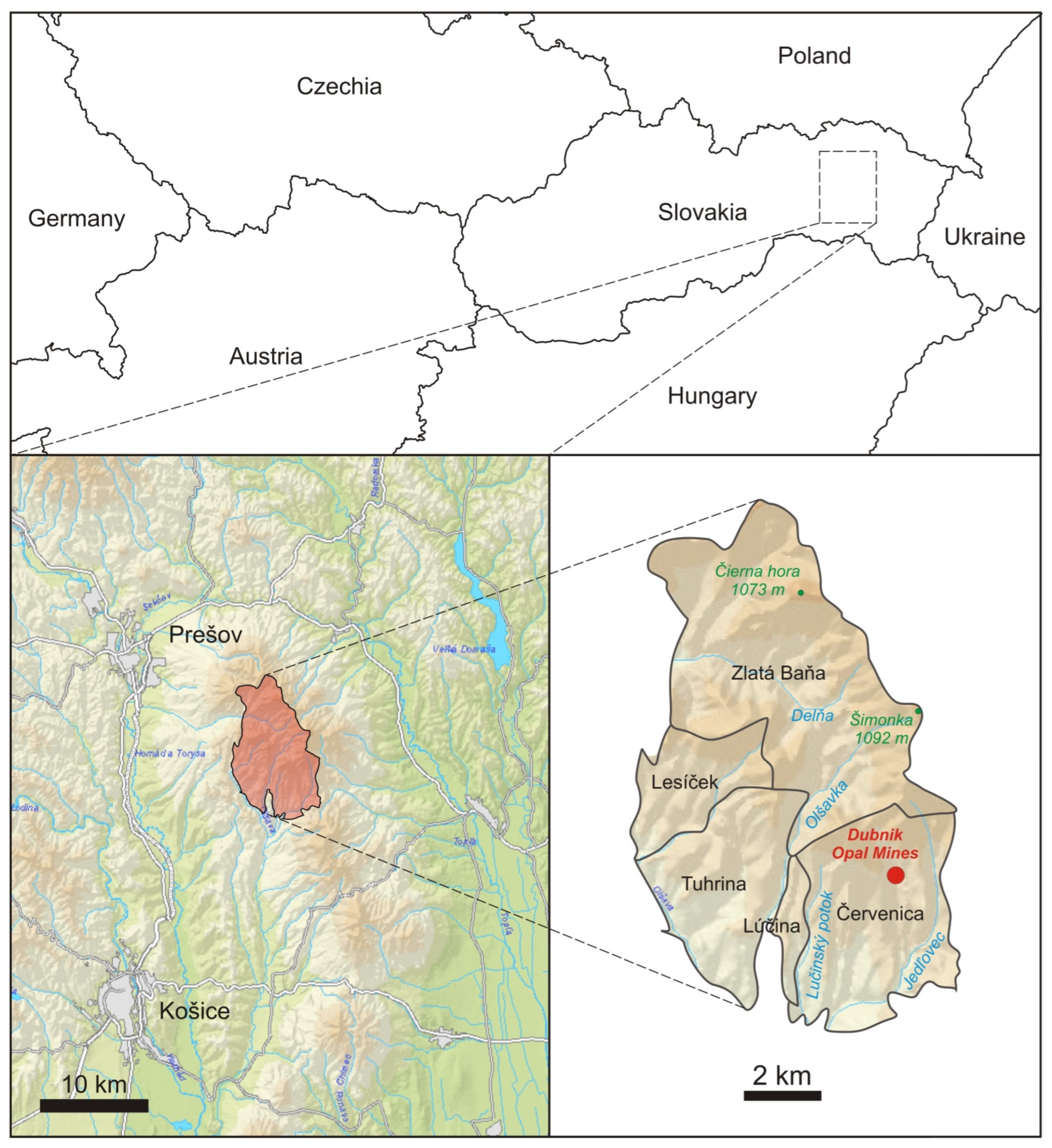
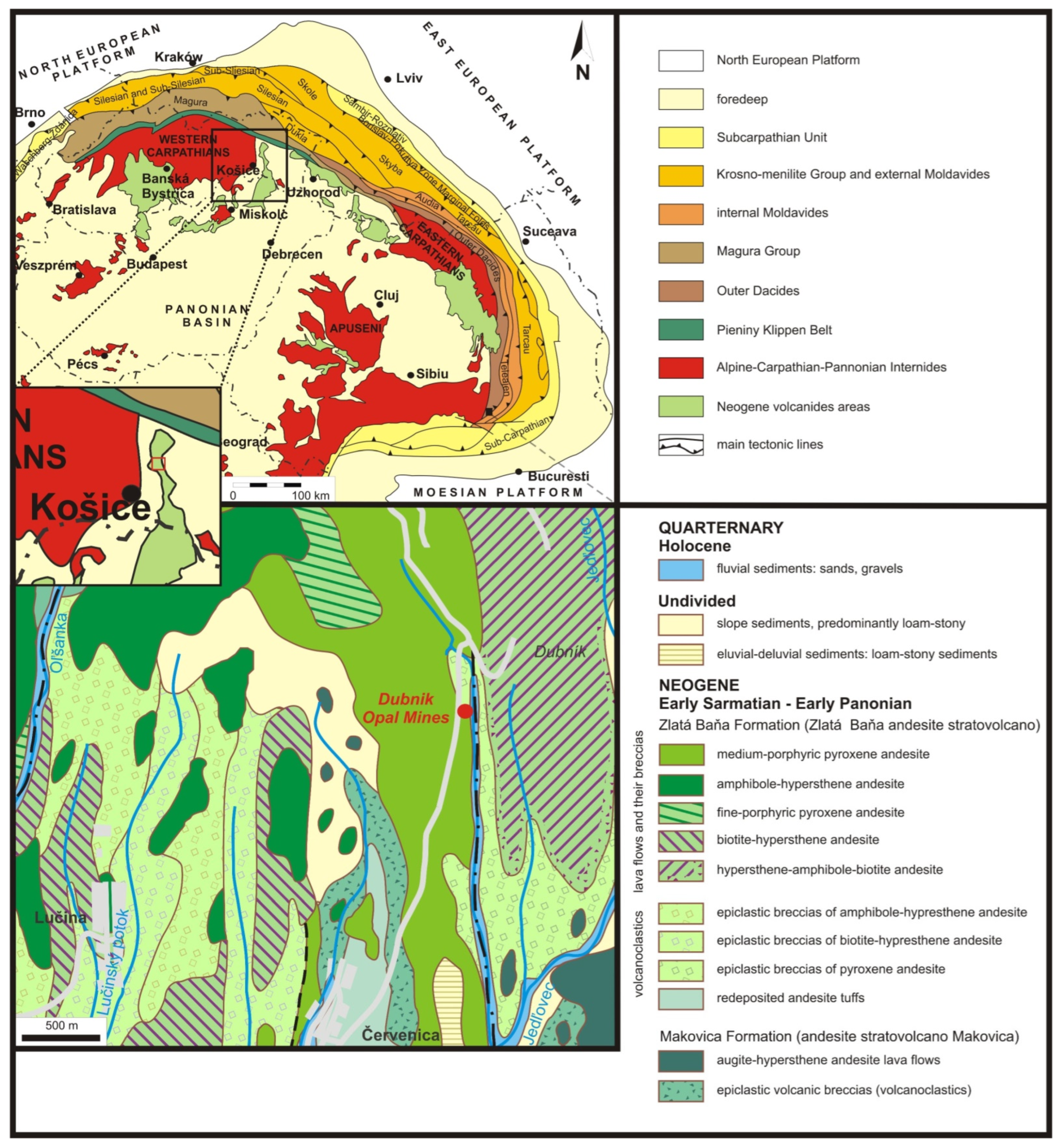
3. Geographic and Geological Overview
4. Geoheritage of the Study Area
4.1. Post-Magmatic Mineralization
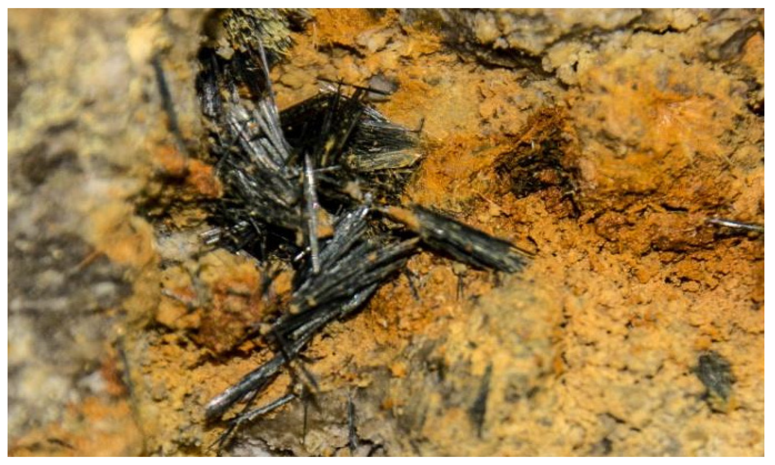
4.1.1. Polymetallic Formation
4.1.2. Antimonite Formation
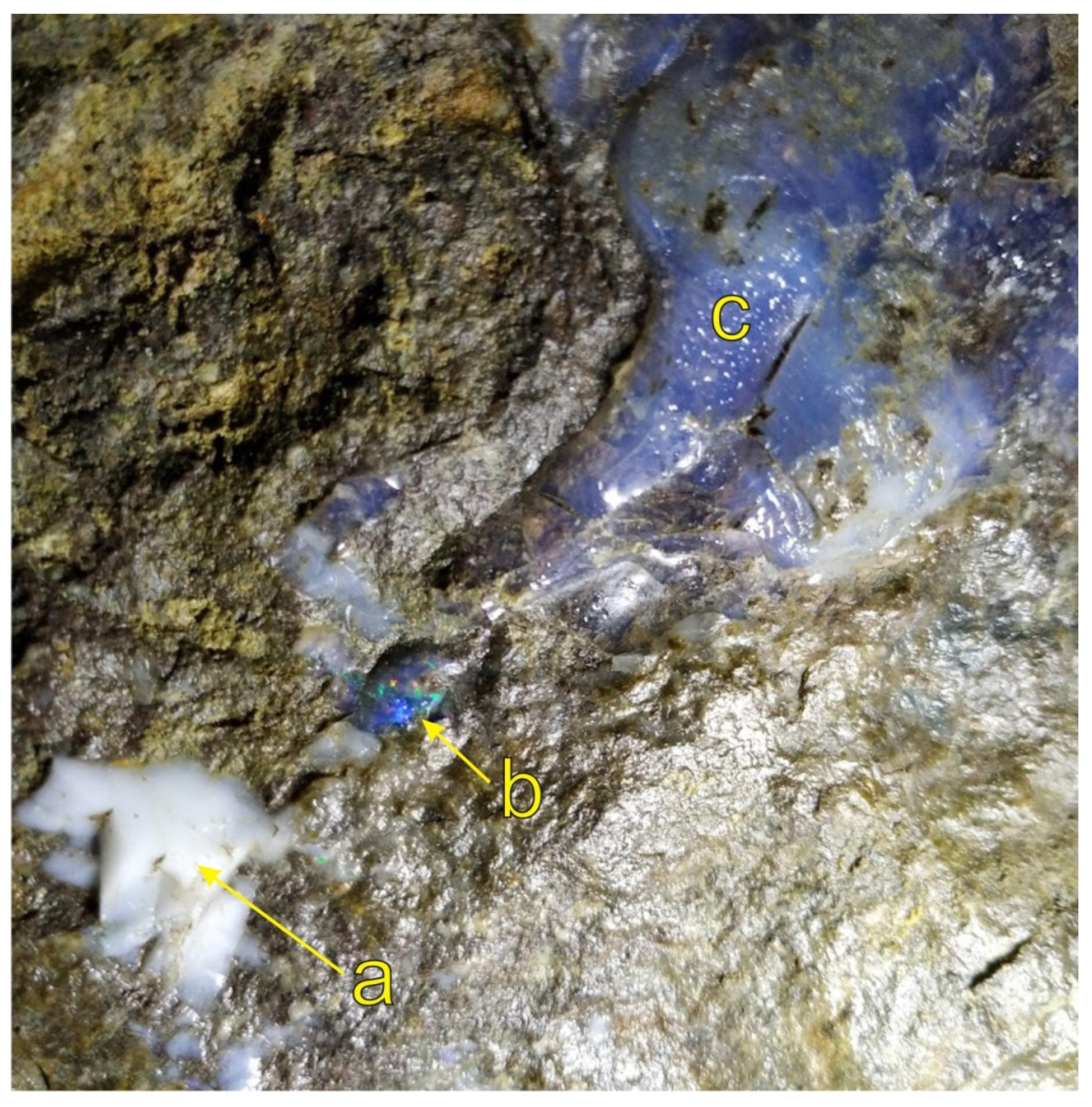
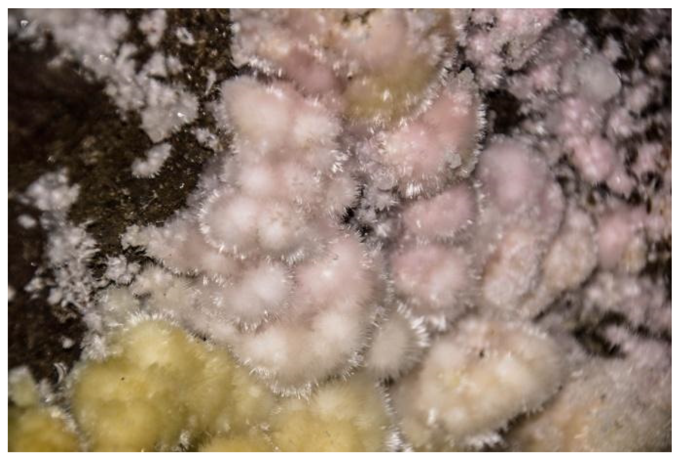
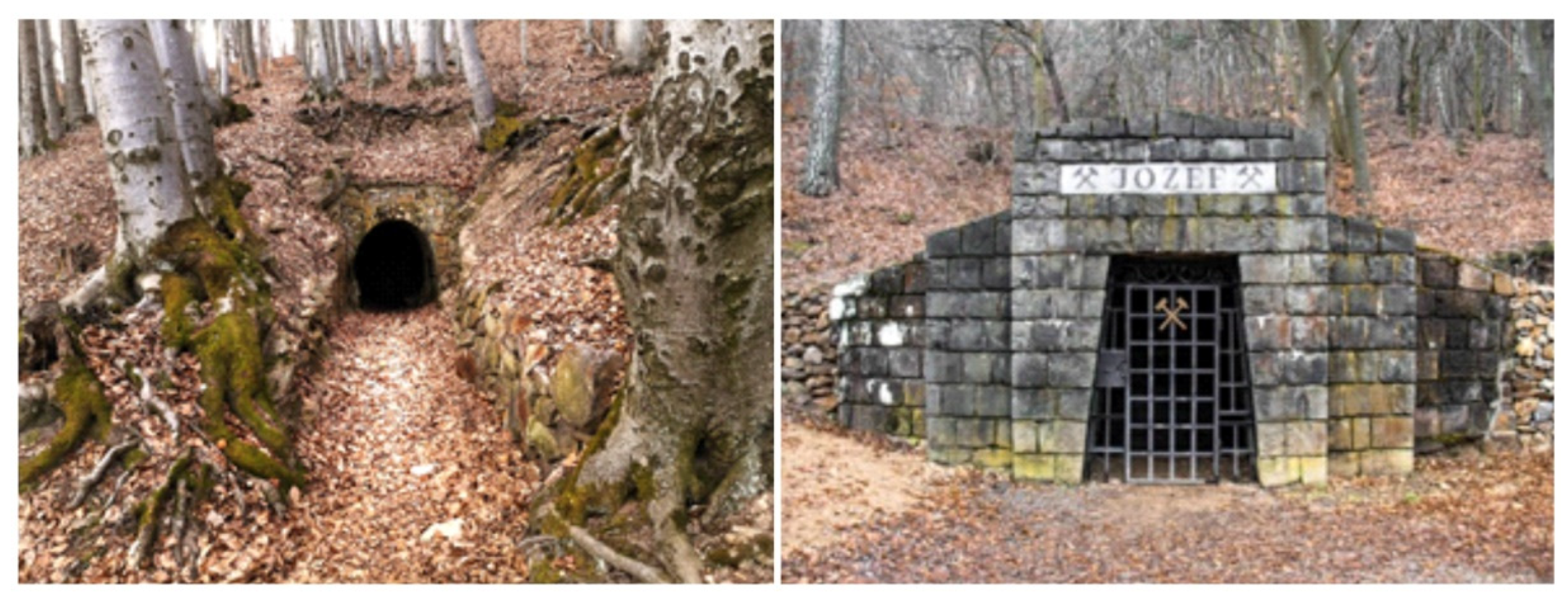
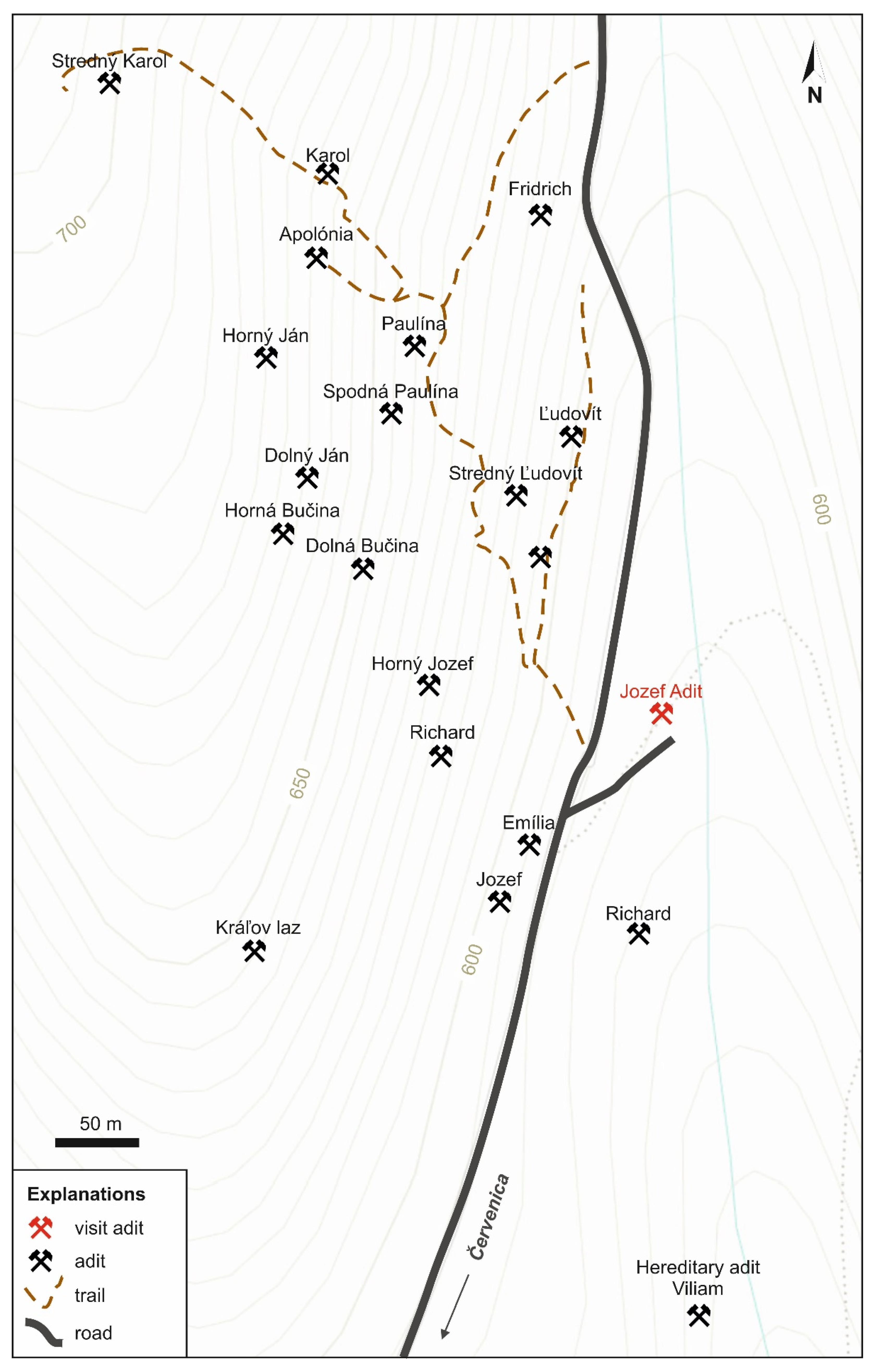
4.1.3. Opal Formation
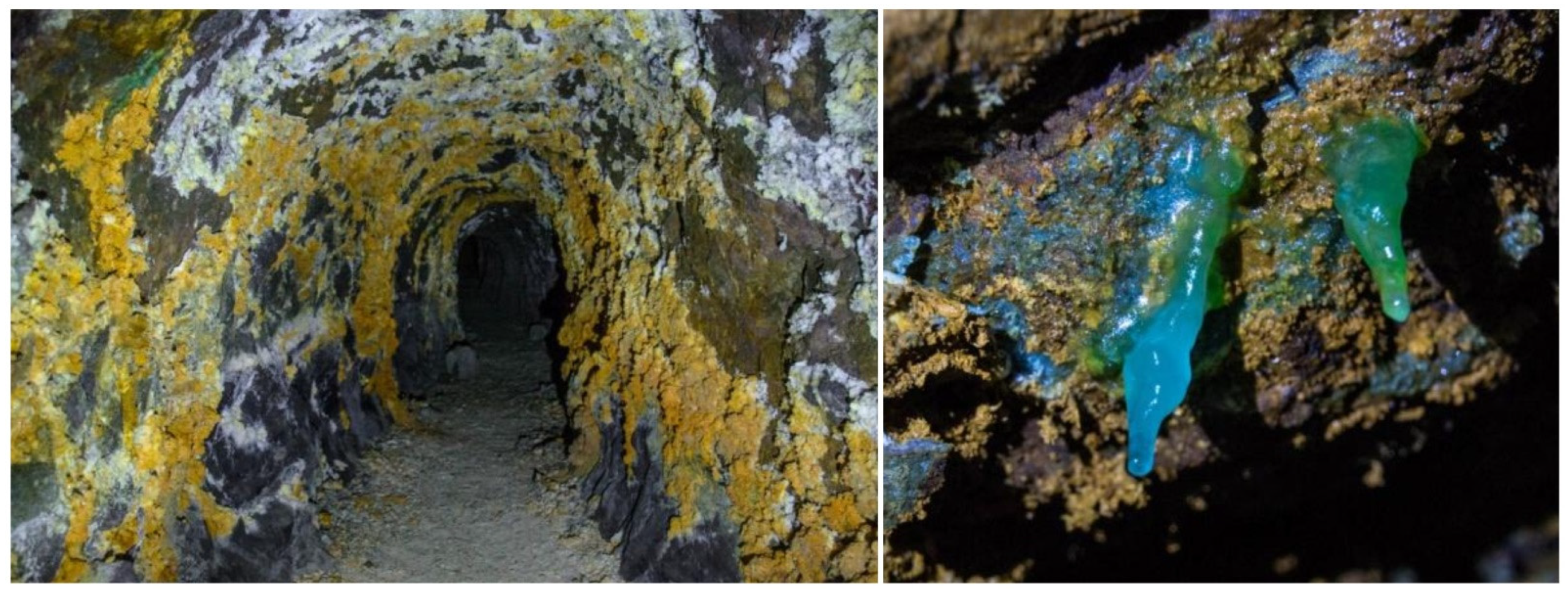
4.2. Mineralization of the Supergene Stage
4.3. Rock Environment of the Zlatá Baňa Stratovolcano
5. Geoeducation and Geotourism Potential of the Area—Discussion
6. Conclusions
Author Contributions
Funding
Institutional Review Board Statement
Informed Consent Statement
Data Availability Statement
Conflicts of Interest
References
- Semrád, P.; Kováč, J. Dubnícke Opálové Bane; Vydavatel’stvo Michala Vaška: Prešov, Slovakia, 2000; 153p. [Google Scholar]
- 543/2002-Zákon o Ochrane Prírody a Krajiny. Available online: https://www.slov-lex.sk/pravne-predpisy/SK/ZZ/2002/543/20210901 (accessed on 5 September 2022).
- ŠOP SR. Dubnické Bane—Územie Európskeho Významu; Štátna Ochrana Prírody SR: Banska Bystrica, Slovakia, 2015. [Google Scholar]
- Semrád, P. The Story of European Precious Opal from Dubník; Granit Ltd.: Praha, Czech Republic, 2011; 215p. [Google Scholar]
- Rondeau, B.; Cenki-Tok, B.; Fritsch, E.; Mazzero, F.; Gauthier, J.-P.; Bodeur, Y.; Bekele, E.; Gaillou, E. Geochemical and petrological characterization of gem opals from Wegel Tena, Wollo, Ethiopia: Opal formation in an Oligocene soil. Geochem. Explor. Environ. Anal. 2012, 12, 93–104. [Google Scholar] [CrossRef]
- Butkovič, Š. História Slovenského Drahého Opálu; ALFA: Bratislava, Slovakia, 1970; 267p. [Google Scholar]
- Ďuďa, R. Mineralógia Severnej Časti Slanských Vrchov; ALFA: Bratislava, Slovakia, 1981; 98p. [Google Scholar]
- Semrád, P. Svet Minerálov: Európske Drahoopálové Ložiská v Dubníku; Granit Ltd.: Praha, Czech Republic, 2017; 219p. [Google Scholar]
- Dowling, R.K. Geotourism’s Global Growth. Geoheritage 2011, 3, 1–13. [Google Scholar] [CrossRef]
- Dowling, R.K. Global Geotourism—An Emerging Form of Sustainable Tourism. Czech J. Tour. 2013, 2, 59–79. [Google Scholar] [CrossRef] [Green Version]
- Hose, T.A. 3G’s for modern geotourism. Geoheritage 2012, 4, 7–24. [Google Scholar] [CrossRef]
- Chen, A.; Lu, Y.; Ng, Y.C.Y. The Principles of Geotourism; Springer: Berlin, Germany; Science Press: Beijing, China, 2015. [Google Scholar]
- Sadry, B.N. The Scope and Nature of Geotourism in the 21st Century. In The Geotourism Industry in the 21st Century: The Origin, Principles, and Futuristic Approach; Sadry, B.N., Ed.; Apple Academic Press: Burlington, ON, Canada, 2021; pp. 3–22. [Google Scholar]
- Brocx, M.; Semeniuk, V. The 8Gs—A blueprint for Geoheritage, Geoconservation, Geo-education and Geoutourism. Aust. J. Earth Sci. 2019, 66, 803–821. [Google Scholar] [CrossRef]
- Poch, J. Geoethics: Basic Concepts and Its Potential for UNESCO Geoparks. In Geoethics In Latin America; Acevedo, R.J., Friás, J.M., Eds.; Springer: Cham, Switzerland, 2018; pp. 7–20. [Google Scholar]
- Global Geoparks Network Code of Ethics. Available online: https://globalgeoparksnetwork.org/wp-content/uploads/2016/07/GLOBAL-GEOPARKS-NETWORK-CODE-OF-ETHICS-final.pdf (accessed on 9 December 2022).
- Pimentel, N.; Pereira, B.; Cabau, I.; Reis Silva, M. Geoeducating Students, Teachers, or Both? An Example from the Oeste Aspiring Geopark (Portugal). In Proceedings of the DIGITAL—9th International Conference on UNESCO Global Geoparks, Jeju island, Republic of Korea, 12–16 December 2021. [Google Scholar]
- Zafeiropoulos, G.; Drinia, H.; Antonarakou, A.; Zouros, N. From Geoheritage to Geoeducation, Geoethics and Geotourism: A Critical Evaluation of the Greek Region. Geosciences 2021, 11, 381. [Google Scholar] [CrossRef]
- Peppoloni, S.; Di Capua, G. The meaning of geoethics. In Ethical Challenges and Case Studies in Earth Sciences; Wyss, M., Peppoloni, S., Eds.; Elsevier: Amsterdam, The Netherlands, 2015; pp. 3–14. [Google Scholar]
- Aktualizácia Koncepcie Geoparkov SR. Available online: https://www.geopark.sk/wp-content/uploads/2018/12/03vlastnymat2015.pdf (accessed on 7 September 2022).
- Brilha, J. Inventory and quantitative assessment of geosites and geodiversity sites: A review. Geoheritage 2016, 8, 119–132. [Google Scholar] [CrossRef] [Green Version]
- Kaličiak, M.; Baňacký, V.; Jacko, S.; Janočko, J.; Károli, S.; Molnár, J.; Petro, Ľ.; Priechodská, Z.; Syčev, V.; Škvarka, L.; et al. Vysvetlivky ku Geologickej Mape Severnej Časti Slanských Vrchov a Košickej Kotliny—Severná Časť 1:50,000; Geologický Ústav Dionýza Štúra: Bratislava, Slovakia, 1991. [Google Scholar]
- Baláž, B.; Kotuľák, P. Geologická stavba a metalogenéza stratovulkánu Zlatá Baňa. Min.—Svet Nerostu A Drahych Kamenu 2001, IX, 246–248. [Google Scholar]
- Geologická Mapa Slovenska M 1:50,000; Štátny Geologický Ústav Dionýza Štúra: Bratislava, Czech Republic, 2013; Available online: http://apl.geology.sk/gm50js (accessed on 5 September 2022).
- Oszczypko, N. The structural position and tectono-sedimentary evolution of the Polish Outer Carpathians. Prz. Geol. 2004, 52, 780–791. [Google Scholar]
- Slavík, F. Zpráva o Nalezišti Drahého Opálu u Dubníka. Manuscript; Česká Geologická Služba: Praha, Czech Republic; Fond Rukopisných Posudku Státniho Geologického Ústavu v Praze: Praha, Czech Republic, 1920. [Google Scholar]
- Caucia, F.; Marinoni, L.; Leone, A.; Adamo, I. Investigation of the geomological, physical and compositional properties of some opals from Slovakia (“Hungarian” opals). Period. Mineral. 2013, 82, 251–261. [Google Scholar]
- Jones, J.B.; Sanders, J.V.; Segnit, E.R. Structure of opal. Nature 1964, 204, 990–991. [Google Scholar] [CrossRef]
- Keller, P.C. Gemstones and Their Origins; Van Nostrand Reinhold Ed.: New York, NY, USA, 1992. [Google Scholar]
- Koivula, J.I.; Fryer, C.W.; Keller, P.C. Opal from Queretaro, occurrence and inclusions. Gems Gemol. 1983, 19, 87–98. [Google Scholar] [CrossRef]
- Barok, M.; Semrád, P. Dubnický Opál—Drahokam Známy i Neznámy; Harlequin Quality Spol. s.r.o.: Košice, Slovakia, 2001. [Google Scholar]
- Bellová, S. Kryštalochémia a Analytické Možnosti Štúdia Fe, Mg, Al Sulfátov. Bachelor’s Thesis, Univerzita Komenského—Prírodovedecká Fakulta, Bratislava, Slovakia, 2014. [Google Scholar]
- Gabrik, L. Obsah Ťažkých Kovov vo Vybraných Zložkách Životného Prostredia v Oblasti Opálových Baní Dubník. Master’s Thesis, Prešovská Univerzita—Fakulta humanitných a Prírodných Vied, Prešov, Slovakia, 2015. [Google Scholar]
- Barok, M.; Molnár, J. Najkrajším slovenským drahokamom je opál. Min.—Svet Nerostu A Drahých Kamenu 2001, IX, 295–299. [Google Scholar]
- Vujičíć, M.D.; Vasiljević, D.A.; Marković, S.B.; Hose, T.A.; Lukić, T.; Hadžić, O.; Janićević, S. Preliminary geosite assessment model (GAM) and its application on Fruška Gora Mountain, potential geotourism destination of Serbia. Acta Geogr. Slov. 2011, 51, 361–377. [Google Scholar] [CrossRef]
- Morante-Carballo, F. Sites of Geological Interest Assessment for Geoeducation Strategies, ESPOL University Campus, Guayaquil, Ecuador. Land 2022, 11, 771. [Google Scholar] [CrossRef]
- Herrera-Franco, G.; Carrión-Merro, P.; Montalván-Burbano, N.; Caicedo-Potosí, J.; Berrezueta, E. Geoheritage and geosites: A bibliometric Analysis and Literature Review. Geosciences 2022, 12, 169. [Google Scholar] [CrossRef]
- Grofelnik, H. Geoheritage and tourism—Opportunities for growth. Tour. South. East. Eur. 2021, 6, 329–342. [Google Scholar]
- Klamár, R.; Matlovič, R.; Mitura, T.; Kowalik-Buczek, M.; Kopor, I. Development of geotourism and mining heritage on the examples of Slovak Opal Mines and Oil Mine Bóbrka. SGEM Int. Multidiscip. Sci. GeoConference SGEM 2017, 17, 241–248. [Google Scholar]
- Nashihuddin, W.; Etikanadya, L.; Asmarany, C.; Djunaedi, A. The science Literacy Programs for Educational Tourism ‘Geopark’ in Kebumen Regency—Indonesia. In Proceedings of the ALIRG 2019 (The 11th Asia Library and Information Research Group Workshop)—“Cooperation, Development and Innovation for Asia Library and Information Science”, Beijing, China, 28–29 November 2019. [Google Scholar]
- Grigorescu, D.A. From Scientific Research to Geoconservation and Geopark. Geoconserv. Res. 2020, 3, 8–31. [Google Scholar]
- Lukáč, M.; Štrba, Ľ.; Černega, A.; Khouri, S. Recent State Policy and Its Impact on Geopark Establishment and Operation in Slovakia. Land 2021, 10, 1069. [Google Scholar] [CrossRef]
- Geoparks of the Slovak Republic. Available online: http://geopark.sk/wp-content/uploads/2018/12/priloha_2.pdf (accessed on 22 March 2020).
- Novohrad-Nograd Geopark. Available online: http://www.globalgeopark.org/aboutGGN/list/HungarySlovakia/6438.htm (accessed on 23 March 2020).
- Rossi, G.S.; Motta Garcia, M.G.; Marie Bourotte, C.L. Educational Materials on Geosciences: Analysis from UNESCO Global Geoparks and Potential for Application to Protected Areas. Geoconserv. Res. 2022, 5, 165–194. [Google Scholar]
- Justice, S.C. UNESCO Global Geoparks, Geotourism and Communication of the Earth Sciences: A case Study in the Chablais UNESCO Global Geopark, France. Geosciences 2018, 8, 149. [Google Scholar] [CrossRef] [Green Version]
- National Geographic. Geo-Education. Available online: https://www.nationalgeographic.org/education/geo-education-essential-preparation-interconnected-world/ (accessed on 23 September 2022).
- Comănescu, L.; Nedelea, A. Geoheritage and Geodiversity Education in Romania: For-mal and Non-Formal Analysis Based on Questionnaires. Sustainabiliity 2020, 12, 9180. [Google Scholar] [CrossRef]
- Slovenské Opálové Bane. Available online: https://www.slovenskeopalovebane.sk/en/home (accessed on 20 June 2022).
- Macadam, J. Geoheritage: Getting the message across. What message and to whom? In Geoheritage—Assessment, Protection, and Management; Brilha, J., Reynard, E., Eds.; Elsevier: Amsterdam, The Netherlands, 2018; pp. 267–288. [Google Scholar]
- Migoń, P. Geo-interpretation: How and for whom? In Handbook of Geotourism; Dowling, R.K., Newsome, D., Eds.; Edward Elgar Publishing: Cheltenham, UK, 2018; pp. 224–233. [Google Scholar]
- Stolz, J.; Megerle, H.E. Geotrails as a Medium for Education and Geotourism: Recommendations for Quality Improvement Based on the Result of a Research Project in the Swabian Alb UNESCO Global Geopark. Land 2022, 11, 1422. [Google Scholar] [CrossRef]
- Modrej, D.; Fajmut Štrucl, S.; Hartmann, G. Results of the geointerpretation research in the frame of the Danube GeoTour project. Geologija 2018, 61, 101–110. [Google Scholar]
- He, Z.; Wu, L.; Li, X. When are meets tech: The role of augmented reality in enhancing museum experiences and purchase intentions. Tour. Manag. 2018, 68, 127–139. [Google Scholar] [CrossRef]
- Özkul, E.; Kumlu, S.T. Augmented reality applications in tourism. Int. J. Contemp. Tour. Res. 2019, 2, 107–122. [Google Scholar] [CrossRef] [Green Version]
- Economou, M. A world of interactive exhibits. In Museum Informatics; Marty, P., Jones, K., Eds.; Routledge: Abington, UK, 2007; pp. 137–156. [Google Scholar]
- Kordos, L.; Meszaros, I.; Szarvas, I. Tracking a “Prehistoric Pompeii”, Rhinoland and Crocodilia: New Discoveries And Interpretations Of Ipolytarnóc (N Hungary) Lower Miocene Track Site. Geoconserv. Res. 2021, 4, 621–634. [Google Scholar]
- Schmid-Röhl, A.P. The Lower Jurassic Posidonia Shale in the Swabian Alp Geopark—Geoeducation in an Industrial Environment. Geoconserv. Res. 2021, 4, 338–346. [Google Scholar]
- Kohmoto, D. Characteristics of map information on the websites of global geoparks and Japanese geoparks. Int. J. Geoherit. Parks 2014, 2, 100–108. [Google Scholar]
- Maiellaro, N.; Varasano, A. One-Page Multimedia Interactive Map. ISPRS Int. J. Geo-Inf. 2017, 6, 34. [Google Scholar] [CrossRef]
- Ren, F.; Simonson, L.; Pan, Z. Interpretation of Geoheritage for Geotourism—A Comparison of Chinese geoparks and National Parks in the United States. Czech J. Tour. 2013, 2, 105–125. [Google Scholar] [CrossRef]
- Farsani, N.T.; de Carvalho, C.N.; Xu, K. Education as a key tenet of geotourism. In Handbook of Geotourism; Dowling, R., Newsome, D., Eds.; Edward Elgar Publishing: Cheltenham, UK, 2018; pp. 234–243. [Google Scholar]
- Tam, L. World Heritage Interpretation, Sustainable Tourism Management and Community Development—Case Study of Luang Prabang, Lao PDR. Master’s Thesis, Katholieke Universiteit, Leuven, Belgium, 2017. [Google Scholar]
- Uzzel, D. Interpreting Our Heritage: A Theoretical Interpretation. In Contemporary Issues in Heritage and Environmental Interpretation: Problems and Prospect; Uzzel, D., Ballantyne, R., Eds.; The Stationery Office: London, UK, 1998; pp. 11–25. [Google Scholar]


| Potential Educational Use | |||
|---|---|---|---|
| Criteria/Indicator | Score | Weight | Weighted Score |
| Vulnerability: | |||
| The geological elements of the geosite present no possible deterioration by anthropic activity | 4 | 10 | 40 |
| Accessibility: | |||
| Site is located less than 100 m from a paved road and with bus parking | 4 | 10 | 40 |
| Use limitations: | |||
| The site has no limitations to being used by students and tourists | 4 | 5 | 20 |
| Safety: | |||
| Site with safety facilities (fences, stairs, handrails, etc.), mobile phone coverage, and located less than 25 km from emergency services | 3 | 10 | 30 |
| Logistics: | |||
| Lodging and restaurants for groups of 50 persons less than 50 km away from the site | 3 | 5 | 15 |
| Density of population: | |||
| Site is located in a municipality with less than 100 inhabitants/km2 | 1 | 5 | 5 |
| Association with other values: | |||
| Occurrence of several ecological and cultural values less than 10 km away from the site | 3 | 5 | 15 |
| Scenery: | |||
| Site is currently used as a tourism destination in local campaigns | 2 | 5 | 10 |
| Uniqueness: | |||
| The site shows unique and uncommon features considering this and neighboring countries | 4 | 5 | 20 |
| Observation conditions: | |||
| All geological elements are observed in good conditions | 4 | 10 | 40 |
| Didactic potential: | |||
| The site presents geological elements that are taught at all teaching levels | 4 | 20 | 80 |
| Geological diversity: | |||
| There are three types of geodiversity elements in the site | 3 | 10 | 30 |
| Total score | 345 |
| Potential Touristic Use | |||
|---|---|---|---|
| Criteria/Indicator | Score | Weight | Weighted Score |
| Vulnerability: | |||
| The geological elements of the geosite present no possible deterioration by anthropic activity | 4 | 10 | 40 |
| Accessibility: | |||
| Site is located less than 100 m from a paved road and with bus parking | 4 | 10 | 40 |
| Use limitations: | |||
| The site has no limitations to being used by students and tourists | 4 | 5 | 20 |
| Safety: | |||
| Site with safety facilities (fences, stairs, handrails, etc.), mobile phone coverage, and located less than 25 km from emergency services | 3 | 10 | 30 |
| Logistics: | |||
| Lodging and restaurants for groups of 50 persons less than 50 km away from the site | 3 | 5 | 15 |
| Density of population: | |||
| Site is located in a municipality with less than 100 inhabitants/km2 | 1 | 5 | 5 |
| Association with other values: | |||
| Occurrence of several ecological and cultural values less than 10 km away from the site | 3 | 5 | 15 |
| Scenery: | |||
| Site is currently used as a tourism destination in local campaigns | 2 | 15 | 30 |
| Uniqueness: | |||
| The site shows unique and uncommon features considering this and neighboring countries | 4 | 10 | 40 |
| Observation conditions: | |||
| All geological elements are observed in good conditions | 4 | 5 | 20 |
| Interpretative potential: | |||
| The public needs to have some geological background to understand the geological elements of the site | 3 | 10 | 30 |
| Economic level: | |||
| The site is located in a municipality with a household income lower than the national average | 1 | 5 | 5 |
| Proximity of recreational areas: | |||
| Site located less than 15 km from a recreational area or tourist attraction | 2 | 5 | 10 |
| Total score | 300 |
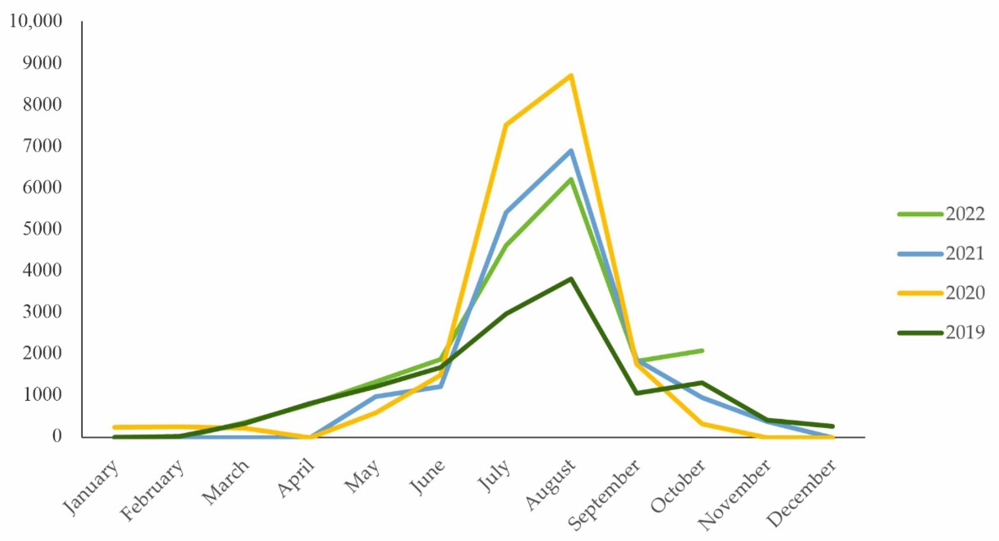
| Month/Year | 2022 | 2021 | 2020 | 2019 |
|---|---|---|---|---|
| January | 0 | 0 | 251 | 8 |
| February | 0 | 0 | 262 | 34 |
| March | 369 | 0 | 228 | 346 |
| April | 806 | 0 | 0 | 822 |
| May | 1338 | 979 | 597 | 1231 |
| June | 1886 | 1226 | 1500 | 1684 |
| July | 4616 | 5412 | 7509 | 2969 |
| August | 6200 | 6885 | 8688 | 3810 |
| September | 1834 | 1866 | 1766 | 1069 |
| October | 2084 | 967 | 332 | 1316 |
| November | N/A | 387 | 0 | 424 |
| December | N/A | 0 | 0 | 271 |
| Total | 19,133 | 17,722 | 21,133 | 13,984 |
| Municipality | Site | Distance | Main Feature(s) |
|---|---|---|---|
| Kecerovský Lipovec | rock outcrop | 9 km * | andesite jointing |
| Herľany | geyser | 16 km * | unique cold-water geyser |
| Šimonka | peak | 6.5 km ** | the highest peak of the Slanské Vrchy Mts. |
| Solivar | museum | 19.7 km * | unique complex of technical objects dating from the 17th century used for pumping and cooking salt from brine |
| Zlatá Baňa | mine | 6.1 km * | historical mining of antimony |
| Ploské | tuff canyon | 19.3 km * | approx. 60 m long tuff canyon formed by water erosion with 5 to 12 m high walls |
| Hermanovce | rock cliffs | 13 km ** | the most extensive exposed rock complex in the Slanské Vrchy Mts. consisting of two andesite complexes |
| Rankovce | rock cliffs | 17.3 km * | volcanic rock complex, unique viewpoint |
Publisher’s Note: MDPI stays neutral with regard to jurisdictional claims in published maps and institutional affiliations. |
© 2022 by the authors. Licensee MDPI, Basel, Switzerland. This article is an open access article distributed under the terms and conditions of the Creative Commons Attribution (CC BY) license (https://creativecommons.org/licenses/by/4.0/).
Share and Cite
Palgutová, S.; Štrba, Ľ. Geoheritage of the Precious Opal Bearing Zone in Libanka Mining District (Slovakia) and Its Geotourism and Geoeducation Potential. Land 2022, 11, 2293. https://doi.org/10.3390/land11122293
Palgutová S, Štrba Ľ. Geoheritage of the Precious Opal Bearing Zone in Libanka Mining District (Slovakia) and Its Geotourism and Geoeducation Potential. Land. 2022; 11(12):2293. https://doi.org/10.3390/land11122293
Chicago/Turabian StylePalgutová, Silvia, and Ľubomír Štrba. 2022. "Geoheritage of the Precious Opal Bearing Zone in Libanka Mining District (Slovakia) and Its Geotourism and Geoeducation Potential" Land 11, no. 12: 2293. https://doi.org/10.3390/land11122293