Article

Ecological Disturbance of Rural Settlement Expansion: Evidence from Nantong, Eastern China

1
Key Laboratory of National Geographic Census and Monitoring, Ministry of Natural Resources, Wuhan University, Wuhan 430079, China
2
School of Resource and Environmental Sciences, Wuhan University, Wuhan 430079, China
3
Faculty of Architecture and Civil Engineering, Huaiyin Institute of Technology, Huai’an 223001, China
4
Shenzhen Urban Planning and Land Resources Research Center, Shenzhen 518000, China
*
Author to whom correspondence should be addressed.
Land 2022, 11(10), 1741; https://doi.org/10.3390/land11101741
Submission received: 21 September 2022 / Revised: 4 October 2022 / Accepted: 6 October 2022 / Published: 8 October 2022
(This article belongs to the Special Issue Land: 10th Anniversary)

Abstract

:
Rural settlements are undergoing a reconstruction process in the context of rapid urbanization, which has a significant impact on ecological land. However, rural settlements encroaching on ecological land (RSEEL) and its associated ecological effects have been widely ignored. This paper aims to accurately and quantitatively evaluate the ecological disturbance caused by RSEEL in China’s rapid urbanization areas. An ecological disturbance index combining changes in both the scale and fragmentation was applied in Nantong, Eastern China. Three types, including jump expansion, extension diffusion, and internal filling, were identified in RSEEL. The results show that the jump expansion type accounted for the largest proportion (58.39%) at the patch level, whereas the extension diffusion was the dominant type at the village level, and the internal filling type was the least common. RSEEL unexpectedly did not make ecological land more fragmented due to the preference for small independent patches in most encroachment cases; hence, the degree of ecological disturbance caused by RSEEL was low in most areas of Nantong. When the encroachment type of RSEEL was combined with the ecological disturbance degree, it was found that the ecological disturbance caused by the jump expansion type was higher than that of the other two types, and extension diffusion and low-level disturbance was the main pattern observed in villages. The findings will contribute to our understanding of the dynamic relationship between rural settlement and ecological land and provide valuable information for rural settlement reconstruction under ecological civilization.

1. Introduction

Land-use changes caused by human disturbances have immediate impacts on the structure and services of ecosystems [1,2]. The threat of ecological land loss owing to human land use has become a tough issue throughout the world [3,4]. Globally, with the accelerated process of urban expansion and agricultural modernization, a gradual transformation of the original natural ecosystem into a new type of ecosystem has been taking place [5,6]. This process has led to a large amount of nature-dominated land with important ecosystem services occupied by human settlements [7,8]. The degradation of ecological functions due to habitat loss [9] and fragmentation [10] has been raising extensive concerns. Efforts have been made to solve these problems around the world in response to the sustainable development goals proposed by the United Nations [11]. However, studies and actions focus mainly on the occupation of ecological land by urban development [12,13]. Rural settlements encroaching on ecological land (RSEEL) and the associated ecological disturbances have been largely ignored.
Rural settlements are comprehensive embodiments of production relations and social connections in the countryside [14,15]. China has witnessed a large rural-to-urban population shift against the background of rapid industrialization and urbanization since the implementation of the reform and opening-up policy in 1978 [16]. Nonetheless, the area of rural settlements has been increasing instead of decreasing [17,18]. On the one hand, this increase has resulted in the inefficient use of rural settlements due to issues such as one household having multiple lands and ‘hollow villages’ [19,20]. On the other hand, the disorderly expansion of rural settlements has occupied ecological space in rural areas [21,22]. Rural settlements expansion is featured by multipoint distribution, fragmentation, and invisibility, which easily results in the neglect of the impacts of RSEEL [23]. Fortunately, the significance of ecological conservation has been realized by China’s government, and policies such as green growth [24] and the ecological red line [25] have been proposed and implemented in recent years. A new pattern of rural development that emphasizes ‘ecological villages’ based on the rural revitalization strategy has been proposed [26]. Paying attention to the spatiotemporal characteristics of RSEEL and its disturbance to ecological land is of great importance in addressing the aforementioned issues and provides guidance for rural settlement reconstruction.
Ecological land refers to land-use types with significant ecological value [27], which play an important role in microclimate regulations, water conservation, and wildlife protection [28], as well as providing ecosystem goods and services [29]. Early studies focused on the definition and classification of ecological land, based mainly on identifying the types or main functions of land use [30]. With the surge in ecological problems caused by rapid urban development, studies have gradually begun to focus on the spatiotemporal distribution and evolution [31], evaluation [32], and protection and optimization [33] of ecological land. Habitat area and fragmentation are the two key points of ecological function and ecological disturbance [34]. Haddad et al. [35] found that habitat fragmentation reduced biodiversity by decreasing biomass and altering nutrient cycles, and the smallest and isolated fragments were most affected. Moreover, Jin et al. [36] have proposed an index that considered both changes in habitat area and fragmentation caused by losses and gains of ecological landscape patches, and found that negative ecological disturbance was more prevalent at the edges of city centers and ecologically sensitive areas. The influences of other land uses on ecological land have been explored [37].
Although ecological land plays an important role in improving the living environment of rural areas [38], little attention has been given to exploring the ecological disturbance caused by rural settlement expansion due to the characteristics of spatial concealment and fragmentation of RSEEL. Scholars have tended to discuss the influencing factors and mechanisms of rural settlement evolution [39,40] as well as the human–land relationship involved in this process [41,42]. The use of internal space in rural settlements [43] and its socioeconomic attributes have also been explored [44]; however, the linkages between rural settlement expansion and ecological land loss remain unclear. Numerous studies have analyzed habitat loss [45] and ecological fragmentation [46], but few have considered both the changes in scale and fragmentation caused by ecological disturbance. Ecological disturbance is usually evaluated by comparing ecological land use at two time points based on remote sensing image data [28,47], which cannot accurately catch the characteristics of spatial concealment and fragmentation of RSEEL. Additionally, two-level (patch level and administrative unit level) analyses have been applied in these studies. The patch level highlights the spatiotemporal characteristics of certain geographical phenomena, while the administrative unit level reflects the differentiation of socioeconomic development. A combined analysis of the two levels is helpful for a comprehensive understanding of ecological disturbance. However, few studies have linked the disturbance characteristics of the two levels to reveal the underlying relations between them.
To fill this research gap, this paper analyzes the spatiotemporal characteristics of RSEEL from 2009 to 2018 in Nantong, Eastern China based on accurate land-use vector data. Moreover, the research contribution of this paper also includes a comprehensive ecological disturbance index that is innovatively proposed to measure the impacts of RSEEL on ecological land in terms of both scale and fragmentation. This study aims to address the following questions: (1) What are the spatiotemporal characteristics and encroachment types of RSEEL in Nantong at the patch level and village level? (2) How to quantitatively evaluate the disturbance caused by RSEEL? (3) What are the underlying relations between encroachment type and ecological disturbance in RSEEL? We expect that the findings will contribute to our understanding of the ecological effects of RSEEL and provide differentiated regional protection suggestions to guide rural settlement planning while constructing an ecological civilization.

2. Materials and Methods
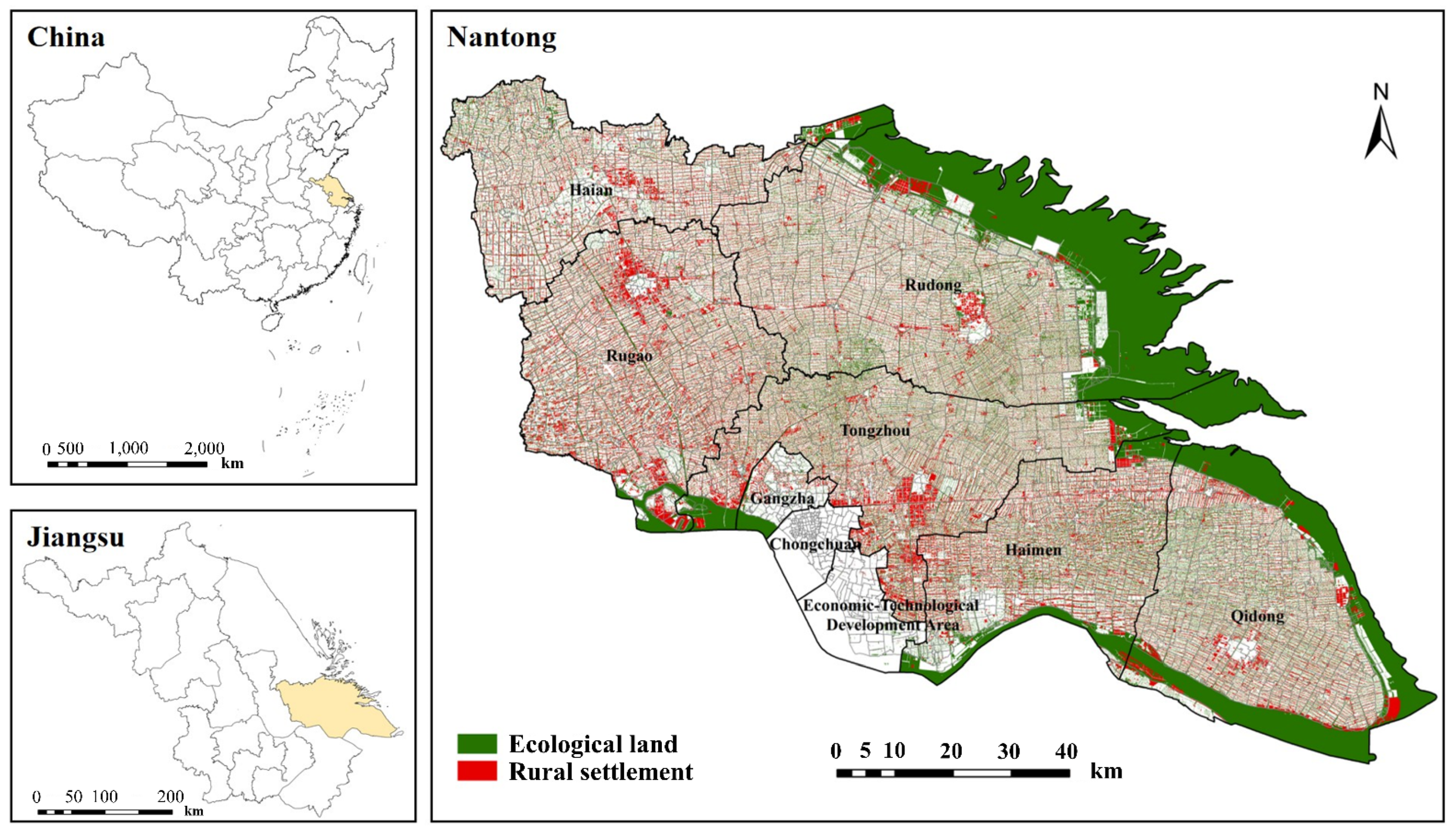
2.1. Study Area

Nantong, located in Jiangsu Province, Eastern China, is the economic center of the North Yangtze River delta region, covering an area of 8544 km2, with nearly 7.63 million residents in 2018. There are four districts, one county, and four county-level cities under the jurisdiction of Nantong, and a total of 2048 administrative villages were taken as the evaluation units in this study (Figure 1). Nantong has significant geographical advantages because it lies at the junction of the coastal economic belt and the Yangtze River economic belt, and it is among the coastal areas of China that have the most abundant land resources. The scale of ecological land in Nantong is as large as 3402.85 km2, accounting for 39.83% of the total area. Meanwhile, the intensity of land space development in Nantong is approaching 20%, which is the internationally recognized livable standard. With the rapid socioeconomic development of Nantong, the conflict between constructed space and ecological space has become increasingly prominent.
Compared with the occupation of ecological land by urban construction land, RSEEL is more implicit. The area of ecological land in Nantong decreased from year to year, from 3618.72 km2 to 3402.85 km2, during the 2009–2018 period, with an average annual reduction of 23.99 km2. However, rural settlements in Nantong expanded continuously, and the settled areas increased by 8.55%, from 1295.60 km2 to 1406.34 km2, during the 2009-period (Figure 2). The area of per capita rural settlement land in Nantong is 192.12 m2, which is beyond the national standard of 150 m2. The expansion of rural settlements will inevitably lead to more ecological land being occupied in Nantong, and there is an urgent need to identify the spatiotemporal characteristics of RSEEL and the associated ecological disturbance. We believe that empirical research in Nantong is conducive to addressing the imbalance between ecologically sustainable development and the rural revitalization involved in RSEEL.

2.2. Data Sources and Processing

The land-use data (1:10,000 scale) were acquired from the Jiangsu Bureau of National Resources Management. To maintain the consistency of land-use data since the second national land survey in 2009, and to ensure the currency of this research, the period of 2009–2018 was chosen as the time interval for RSEEL identification. Based on the existing research [48] combined with the actual situation of Nantong, woodland, grassland, water area, saline–alkali land, swamp land, sandy land, and bare land were defined as ecological land for this paper. Rural settlements and ecological land were extracted from the land-use data of 2048 units in Nantong. The spatiotemporal characteristics of RSEEL were analyzed using the joint tools of ArcGIS 10.2 to overlay the layers between 2009 and 2018. The field calculator, Python code, and VB script were applied to identify the land-use transformation of ecological land to rural settlements.

3. Methods

3.1. Landscape Expansion Index

The landscape expansion index is helpful for revealing the distance relationship between RSEEL patches and original rural settlement patches [19]. A 30 m buffer zone was established for each RSEEL patch and then intersected with the original rural settlement patches. According to the ratio of intersection area and buffer area, the RSEEL landscape expansion index can be obtained. The formula is expressed as follows:
L E I i = 100 × I A i B A i
where L E I i represents the landscape expansion index of RSEEL patch i , and the value range is 0 ≤ L E I i ≤ 100; I A i refers to the intersection area between original rural settlement patches and the buffer zone of RSEEL patch i , and B A i refers to the buffer area of RSEEL patch i . According to the value range of L E I i , the RSEEL pattern can be divided into three types (Figure 3): internal filling (50 < L E I i ≤ 100), extension diffusion (0 < L E I i ≤ 50), and jump expansion ( L E I i = 0).

3.2. Ecological Disturbance Assessment

3.2.1. Landscape Fragmentation Evaluation

Landscape fragmentation reflects the degree of landscape segmentation caused by natural or human factors [49]. The evaluation indicators of landscape fragmentation are different in different studies [34,35,36] due to the differences in the actual situation of the study area, the differences in subjective selection, etc., so, there is no unified indicator standard. However, the average patch area, as the most basic spatial feature of land scale, can be used to show the degree of landscape fragmentation; the smaller the average patch area is, the higher the fragmentation degree. The ecological land-use status of each unit in Nantong without considering the impact of RSEEL can be obtained by restoring RSEEL patches that occurred during the study period to ecological land patches. Compared with the actual land-use status, the change rate of the average patch area of ecological land was obtained to measure the impact of RSEEL on ecological landscape fragmentation. The formula is expressed as follows:
E M P S i = E A i E N i
Δ E M P S i = E M P S i t 0 E M P S i t 0 E M P S i t 0
where E M P S i is the average patch area of ecological land in unit i ; EAi and ENi are the area and number of patches of ecological land in unit i , respectively; Δ E M P S i is the change rate of E M P S i ; E M P S i t 0 is the average patch area of ecological land in unit i at t 0 without considering the impact of RSEEL during the study period; and E M P S i t 0 is the actual average patch area of ecological land in unit i at t 0 .

3.2.2. Ecological Disturbance Index

Compared with the rate of RSEEL, that is, the ratio of RSEEL area to the original ecological land area, the ecological disturbance index comprehensively considers the scale and number of patches occupied by rural settlements on ecological land, enabling the ecological disturbance caused by RSEEL to be measured more thoroughly [50]. The lower the value of the ecological disturbance index, the lower the impact of RSEEL on ecological land. The formula is introduced and expressed as follows:
E D I i = E A i t 1 R A i t 2 E A i t 1 × E N i t 1 R N i t 2 E N i t 1
where E D I i represents the ecological disturbance index of unit i , E A i t 1 refers to the area of ecological land at t 1 in unit i , E A i t 1 R A i t 2 is the area of ecological land converted to rural settlement from t 1 to t 2 in unit i , E N i t 1 is the number of patches of ecological land at t 1 in unit i , and E N i t 1 R N i t 2 is the number of patches converted from ecological land to rural settlement during t 1 t 2 in unit i .

4. Results and Analysis

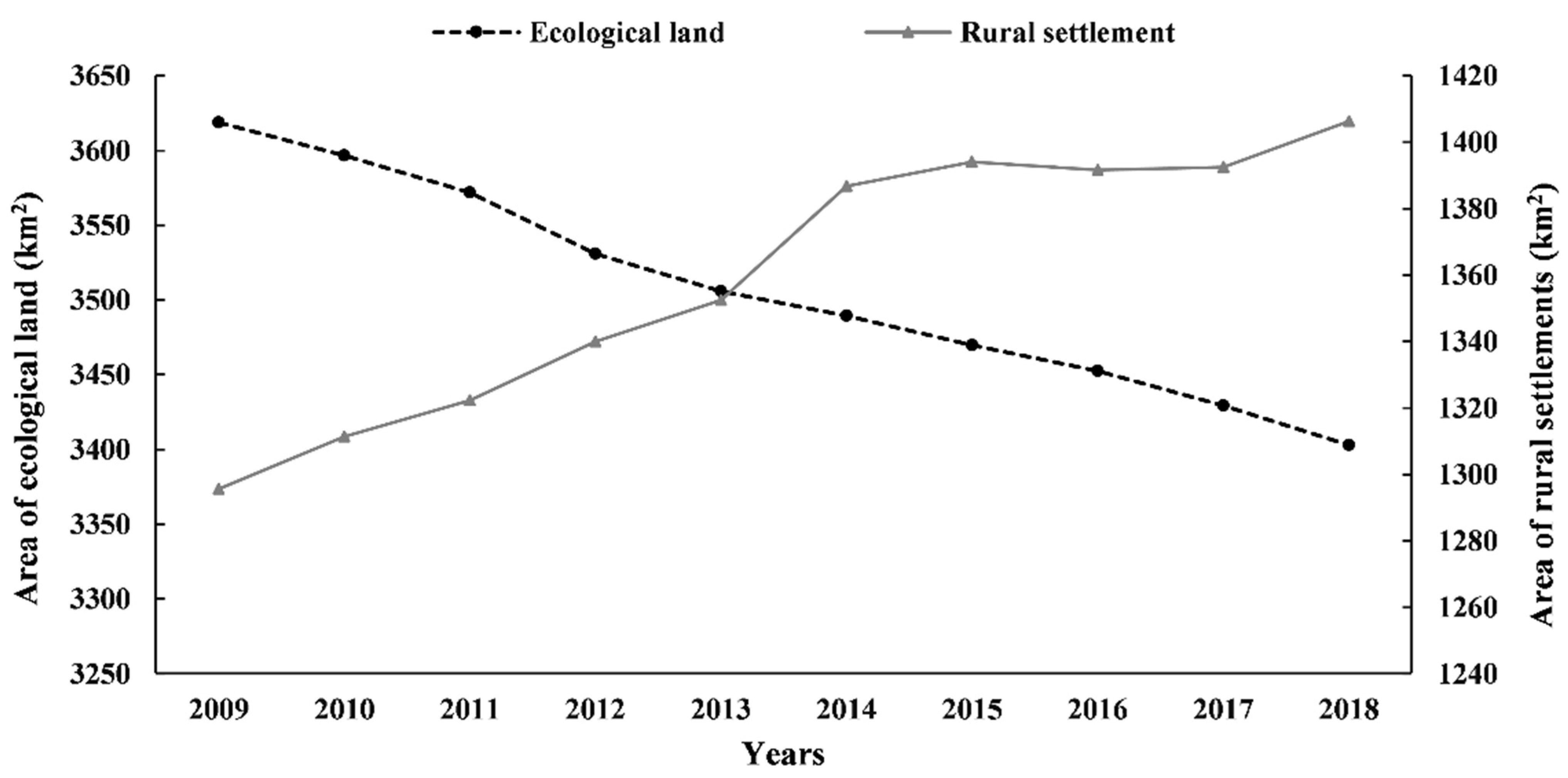
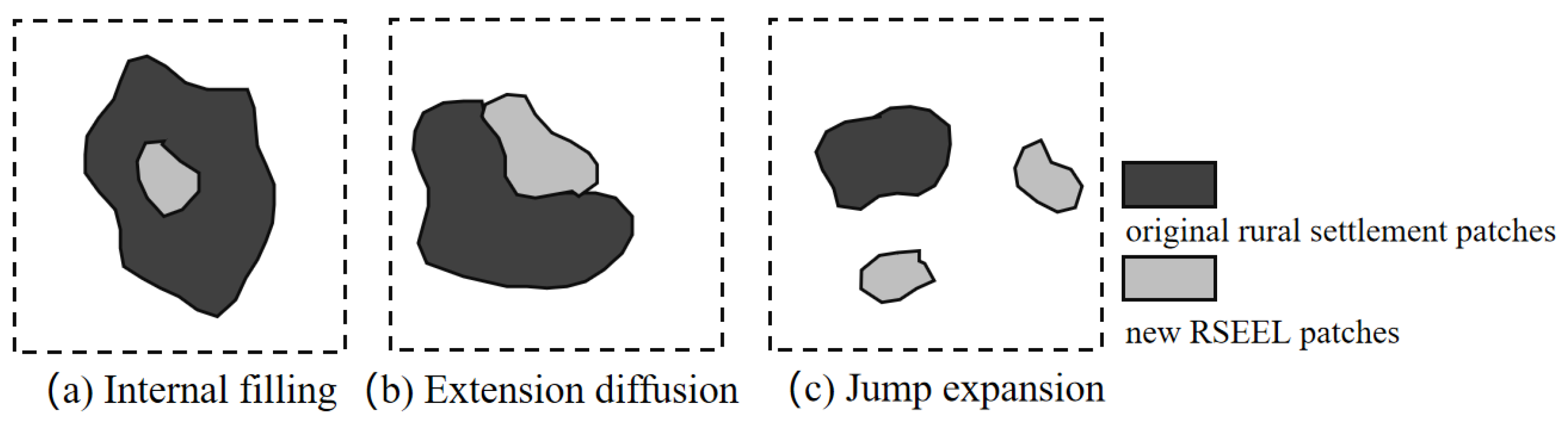
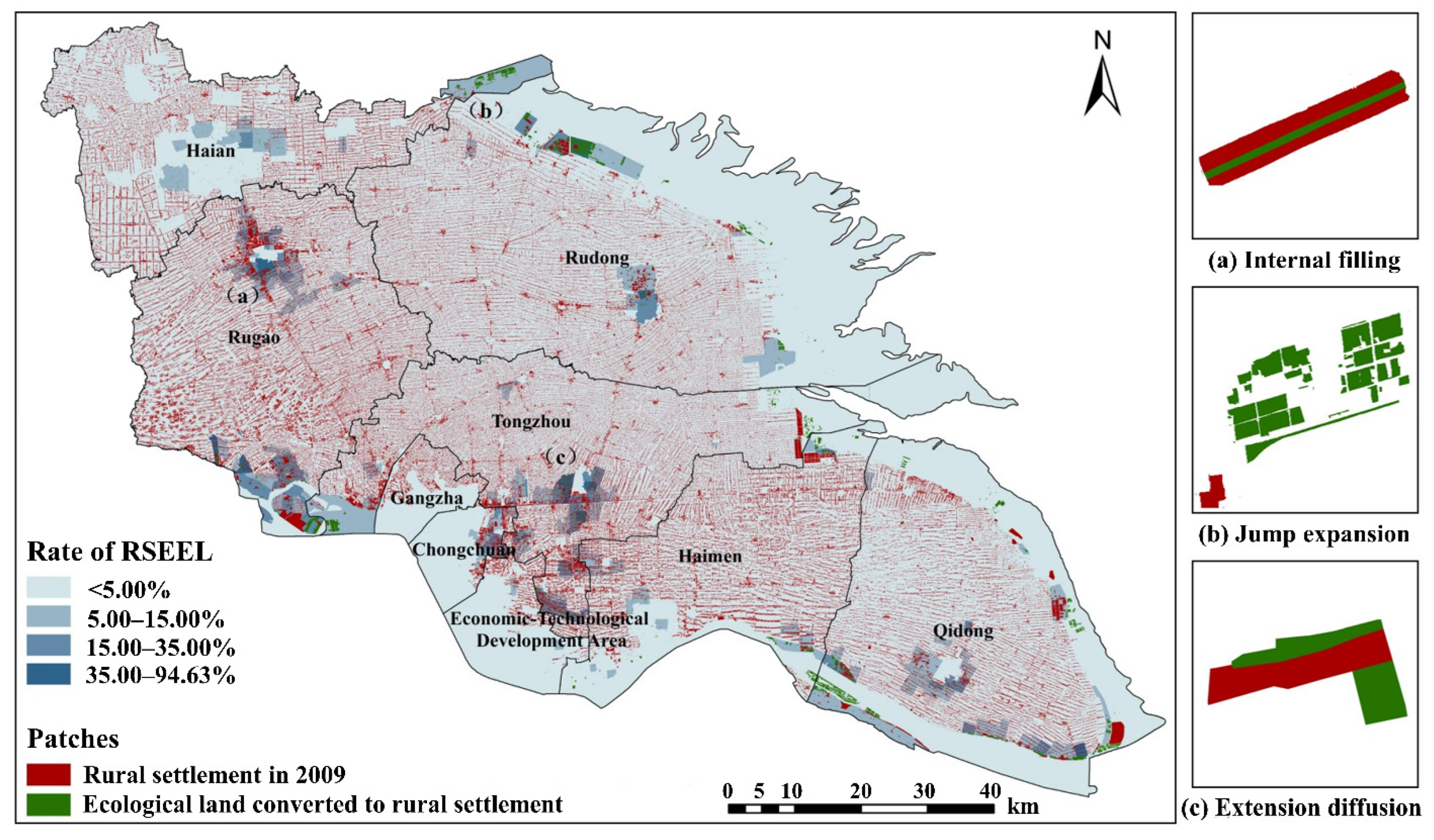
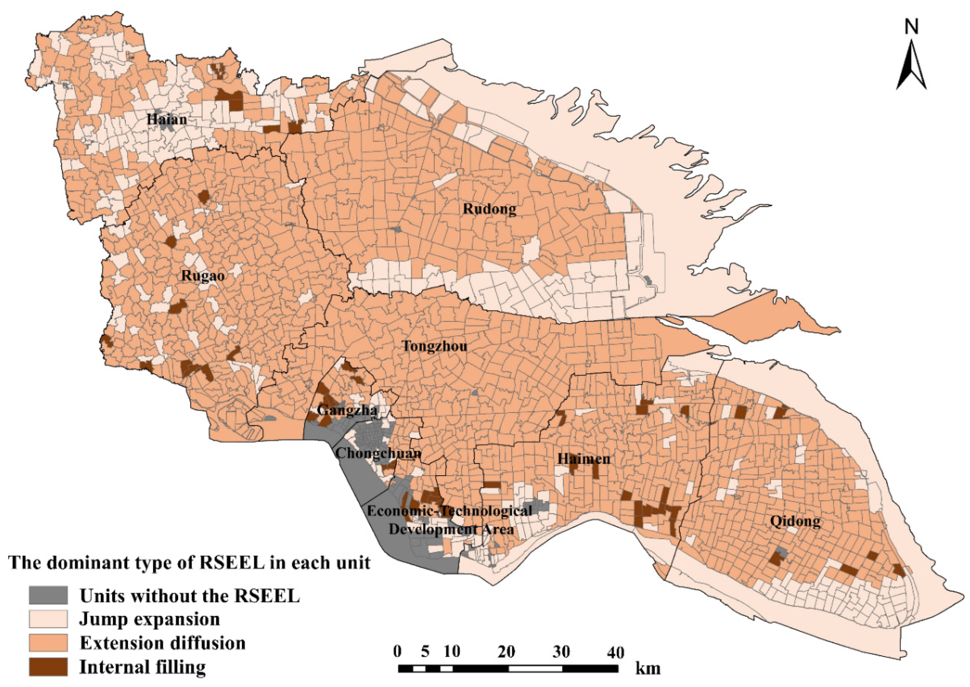
4.1. Spatiotemporal Characteristics of RSEEL in Nantong

From 2009 to 2018, the ecological land in Nantong decreased by 215.87 km2, while the area of rural settlements increased by 110.74 km2. The reduction in ecological land was distributed mainly in Rudong, Qidong, and Tongzhou, where a decrease of 131.38 km2 was observed, accounting for 60.86% of the total decrease. The growth of rural settlements was concentrated mainly in Qidong, Haian, and Rudong, and the total expansion of rural settlements amounted to 83.63 km2, accounting for 75.52% of the total growth. Thus, 64.65 km2 (1.79% of the level in 2009) of ecological land was converted to rural settlements from 2009 to 2018. The rate of RSEEL varied in different counties in Nantong (Figure 4).
The spatial differentiation of RSEEL in Nantong was not obvious at the city scale. However, the administrative villages with a higher rate of RSEEL showed a certain trend of agglomeration and cluster distribution in each county of Nantong. The rate of RSEEL ranged from 0% to 94.63% at the village level, which was higher than that at the county level. The highest RSEEL rate was observed in Yinyang town of Qidong. According to the natural breakpoint method, the rate of RSEEL was divided into four intervals: it was less than 4.66% in 1858 villages out of 2048 villages, and it was over 36.71% in only 15 villages. The villages with a relatively higher RSEEL rate were distributed in northern and southern Rugao, central and southern Tongzhou, and southern Qidong.
According to the value of the landscape expansion index, RSEEL in Nantong can be characterized as three types: internal filling (Figure 5a), jump expansion (Figure 5b), and extension diffusion (Figure 5c). RSEEL patches belonging to the internal filling type occurred in the sandwich zone with high rural settlement proximity, and RSEEL was manifested by the tendency of those occupying ecological land to form contiguous rural settlements. These patches were mainly strip shapes, and dotted patches were found mostly in north-central Rugao. The jump expansion type of RSEEL means that new rural settlements were far from the original rural settlements and emerged mostly in the coastal tidal flats and rivers of Rudong and Qidong. The number of RSEEL patches belonging to the jump expansion type was relatively small; however, those patches were usually blocky, large, and locally concentrated. For extension diffusion, the new rural settlements caused by RSEEL occurred along the borders of the original rural settlements, and their spatial distribution was comparatively even. The area of a single RSEEL patch of the extension diffusion type was very small, and most of them were scattered in the form of dots and strips, as was especially obvious in Tongzhou. In general, in terms of the number of RSEEL patches in Nantong, the extension diffusion type was most common, at 72.20%, and the internal filling type and jump expansion type accounted for 16.20% and 11.60%, respectively. However, in terms of the scale of RSEEL patches, the jump expansion type accounted for 58.39% (38.32 km2), and the extension diffusion type and internal filling type accounted for 26.39 km2 and 0.86 km2, or 40.29% and 1.32%, respectively.

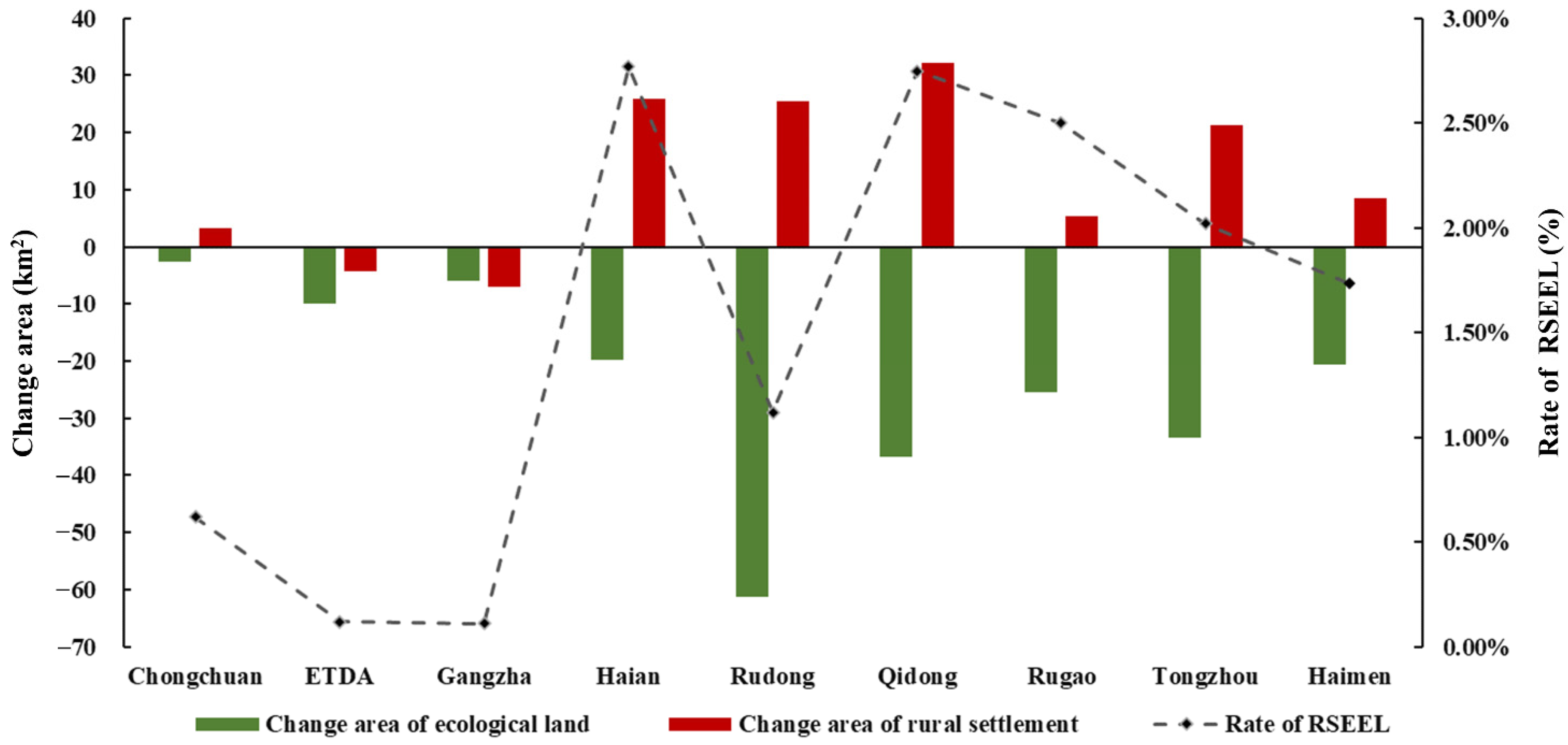
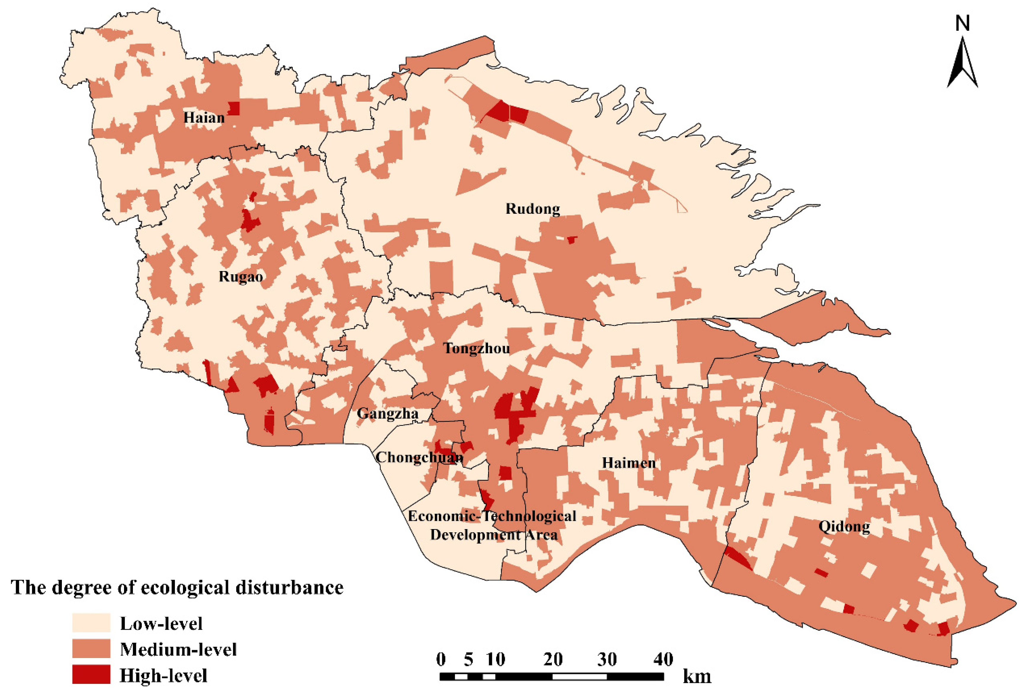
4.2. Ecological Disturbance Evaluation of RSEEL

Rural settlements are characterized by small patches but wide coverage. Their encroachment on ecological land is covert and is of great significance for evaluating the ecological disturbance caused by RSEEL. We quantitatively measured the impact of RSEEL on ecological land from the changes in landscape fragmentation caused by RSEEL and the value of the ecological disturbance index. We used counterfactual analysis and restored the RSEEL patches from 2009–2018 to ecological land to obtain the change rate of the average patch area of ecological land (EMPS) caused by RSEEL. As shown in Figure 6, the change rate in EMPS caused by RSEEL had both positive and negative values. The change rate was negative in only 23 villages (shown as dots in Figure 6), which means that the ecological land became more fragmented under the influence of RSEEL in just a few areas in Nantong, most of which were distributed in Haimen and Rugao. Among them, Yinyang town of Qidong was the most prominent since the average patch area of ecological land decreased by 91.41%, from 8207.38 m2 to 704.75 m2, because of RSEEL. This area was also the region with the highest rate of RSEEL.
As shown in the right half of Figure 6, different colors were used to represent the four degrees of the positive EMPS change rate caused by RSEEL, and the length of the column reflects the number of villages corresponding to a certain degree. In contrast with the expected impact, RSEEL did not improve the fragmentation of the ecological landscape, nor did it lower the stability of the spatial structure of ecological land. On the contrary, the process of RSEEL led to more homogeneous and continuous ecological land with an even larger average patch area since priority was given to individual small patches rather than larger agglomerated patches in the RSEEL. The spatial differentiation of this phenomenon was obvious with significant agglomeration, and the regions with higher change rates in the average patch area were distributed mostly in the central part of Nantong, especially in Tongzhou and Haimen.
In addition to quantifying the impact of RSEEL on the landscape pattern of ecological land in Nantong, it is also necessary to evaluate the ecological disturbance caused by RSEEL through the ecological disturbance index, which considers both the scale of encroachment and the number of occupied patches. The value of the ecological disturbance index ranged from 0 to 1.18; the higher the value, the more serious the ecological disturbance. According to the value and range of EDIi, the degree of ecological disturbance could be divided into three intervals by the natural breakpoint method: low-level disturbance (0 < EDIi ≤ 0.05), medium-level disturbance (0.05 < EDIi ≤ 0.40), and high-level disturbance (0.40 < EDIi ≤ 1.18). As shown in Figure 7, most areas in Nantong suffered low-level ecological disturbance from RSEEL, accounting for 57.52% of all villages. There were only 40 villages where the degree of ecological disturbance was high, and most of them were distributed in Rugao, Tongzhou, Rudong, and Qidong. The value of the ecological disturbance index was the highest at 1.18 in Yangkou town of Rudong, where the rate of RSEEL was up to 62.84%, and the ecological land was more fragmented due to RSEEL. The rate of RSEEL focused on the degree of area conversion from ecological land to rural settlement; however, the ecological disturbance index further revealed regions with a possibly lower total scale of RSEEL but more occupied patches. Compared with Figure 5, some villages with higher ecological disturbance values, especially in western Tongzhou and southern Qidong, were greatly influenced by the number of occupied patches in RSEEL, which affected the form and layout of the original ecological land to a certain extent.

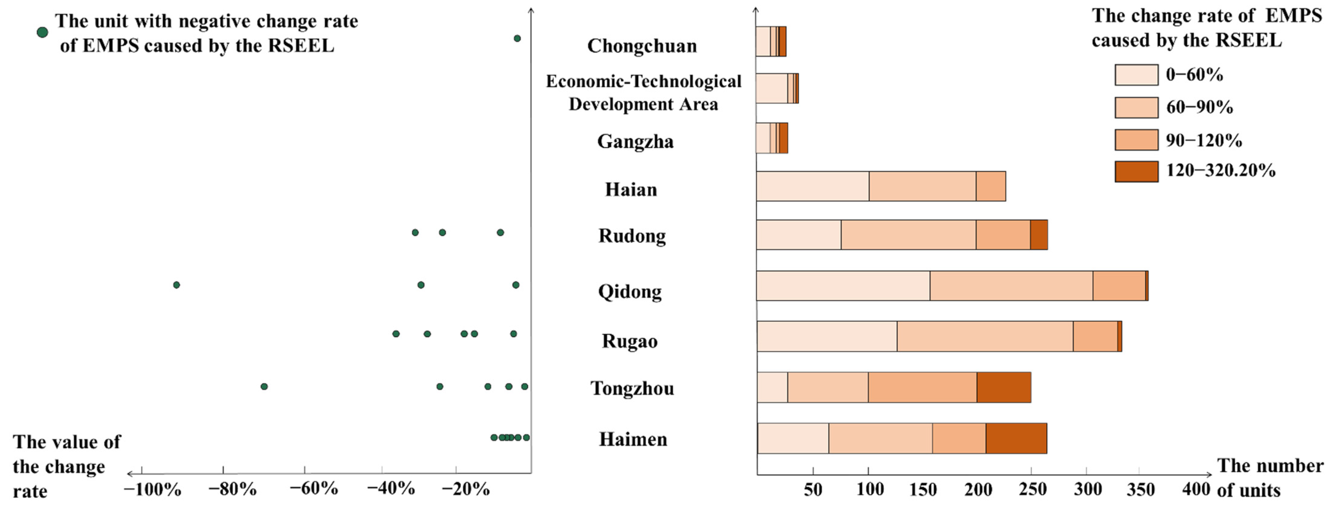
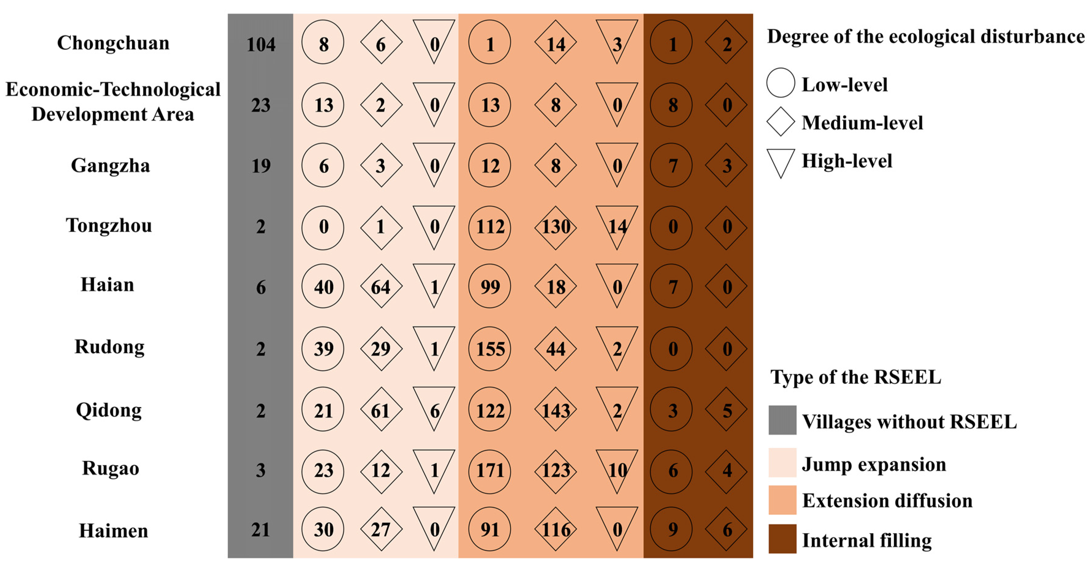
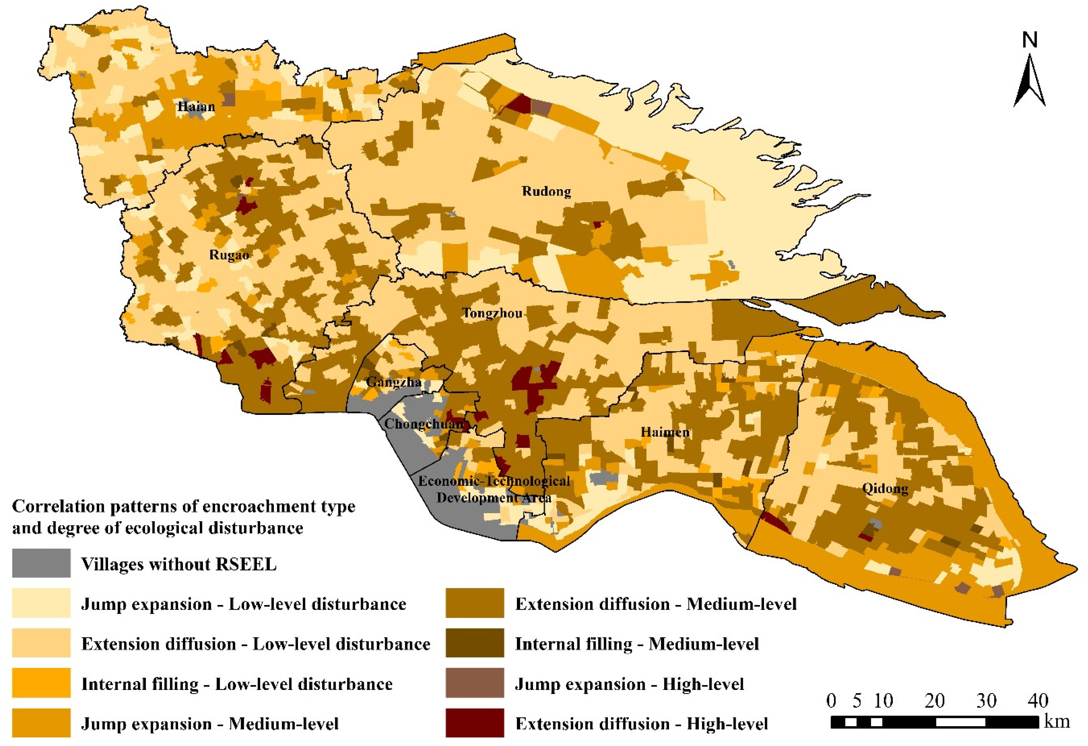
4.3. Correlation between Encroachment Type and Ecological Disturbance in RSEEL

Three types of RSEEL were identified in the previous section. To analyze the situation of RSEEL in Nantong more accurately, the dominant type of RSEEL in each village was further identified by calculating and comparing the scale of each encroachment type in each village. As shown in Figure 8, the dominant type of RSEEL in each village of Nantong had significant agglomerations with spatial differentiation. Most of the villages without RSEEL were concentrated in Chongchuan, Gangzha, and the Economic–Technological Development Area, in which there were few rural settlements. The statistics indicated that except for 182 villages without RSEEL, the area dominated by the extension diffusion type of RSEEL in Nantong was the largest, with a total of 1441 units, and they featured concentrations of connected pieces, especially in Tongzhou. In 394 villages, the jump expansion type of RSEEL was dominant, and they were distributed mainly in the peripheral coastal areas of Rudong and Qidong, as well as the central part of Haian. However, the regions dominated by the internal filling type of RSEEL were relatively scattered, and most of these 61 villages were in western and southern Nantong.
After the dominant type of RSEEL in each unit of Nantong was clarified, it was worth considering whether the encroachment types had a certain relationship with the degree of ecological disturbance caused by them. By combining the dominant encroachment type of each village with its degree of ecological disturbance, this paper comprehensively explored the correlation pattern between the two in RSEEL in Nantong (Figure 9). Although we found no significant correlation between the two through Pearson correlation analysis, we obtained some information from the cross-analysis results, as shown in Table 1. Except for 182 villages without RSEEL, there were eight correlation patterns. In the regions dominated by the jump expansion type of RSEEL, there were 205 villages with medium-level ecological disturbance, a slightly higher number than villages that suffered low-level ecological disturbance. However, the ecological disturbance caused by RSEEL was mostly low in villages dominated by the extension diffusion type and the internal filling type of RSEEL. This phenomenon indicates that the jump expansion type of RSEEL to some extent had a greater disturbance effect than the extension diffusion type and the internal filling type. The internal filling high-level disturbance correlation pattern did not appear in RSEEL in Nantong. The first reason was that the internal filling type of RSEEL was the least common of the three types of encroachment; the second was that it occurred mostly in sandwich zones of adjacent rural settlements or the interior areas of massive rural settlements, where the occupied ecological land was originally separated from other ecological land patches. The impact of RSEEL in this situation was naturally slight. Among the eight correlation patterns of encroachment-type ecological disturbance degree in RSEEL in Nantong, extension diffusion low-level disturbance was the main pattern, with 775 out of 2048 units, followed by extension diffusion medium-level disturbance.
Regarding the differentiation characteristics of these correlation patterns in RSEEL, most of them existed in all nine counties of Nantong (Figure 10); however, villages featuring the jump expansion high-level disturbance pattern were obviously concentrated in Qidong. This RSEEL correlation pattern needs to be taken seriously since the main objects of jump expansion were large-scale important ecological land areas. This RSEEL type would make ecological lands more fragmented, which would influence their original function. The extension diffusion low-level disturbance pattern, which is the least disruptive of the eight RSEEL patterns in Nantong, occurred mainly in Rugao and Rudong. The extensive diffusion type of RSEEL was usually seen in rural settlements with high spatial connectivity that expanded to take full advantage of their location to occupy the surrounding ecological land. Most of the occupied ecological land was distributed along the periphery of the rural settlements in scattered patches around the original ecological land, and encroachment did not affect the general layout of nearby ecological land. Thus, the impact of ecological disturbance was relatively small.

5. Discussion

5.1. Underlying Causes of RSEEL Linked to Different Patterns

The scale of ecological land occupied by rural settlement expansion is increasing due to the internal demands of farmers themselves to expand their homesteads owing to extensive and rapid economic growth [51]. In addition, under the situation of stricter management and control of cultivated land, ecological land has become the preferred choice for rural settlement expansion due to its fuzzy definition and boundary. RSEEL is the common result of insufficient supervision of the disordered expansion of rural settlements and inadequate attention to and protection of ecological land. However, due to the mostly star-dot spatial distribution of rural settlements, the process of RSEEL is relatively difficult to detect compared with the encroachment of urban construction on ecological land.
The encroachment types of RSEEL are jump expansion, extension diffusion, and internal filling. In terms of the scale of RSEEL in Nantong, the jump expansion type was the most common, while the extension diffusion type predominated in terms of the number of occupied patches, and the internal filling type was rare. The spatial differentiation of the encroachment type of RSEEL is related to the structural characteristics of internal ecological land in rural settlements, which are influenced by terrain conditions [52], the stage of socioeconomic development [53], and traditional culture policies [54]. The jump expansion type of RSEEL occurs due to farmers’ inadequate consideration of the impact of this process on ecological land; based on their own interests, in regard to rural settlement expansion, they prefer to develop an independent site for the construction of a new settlement. The jump expansion type of RSEEL usually aims at contiguous ecological land with important functions and leads to the fragmentation of ecological land through large-scale occupation from the interior of a contiguous land area, which causes relatively greater disturbance. Compared with the extension diffusion type and the internal filling type of RSEEL, most ecological land occupied by the jump expansion type of RSEEL is not suitable for rural settlement construction due to its complex landforms. The extension diffusion type and the internal filling type of RSEEL are both fully based on the location advantage and land resources of the original rural settlements. Rural settlements with higher connectivity and proximity seem to have a kind of gravitational effect on small and independent ecological land patches scattered around and among them. Transforming those patches into rural settlements not only makes the overall ecological land less fragmented but also realizes the reorganization and integration of rural settlements. Although these two kinds of encroachment still cause damage to the ecological space of rural settlements, the overall disturbance to ecological land is not significant.

5.2. Policy Suggestions for Rural Settlement Planning under Ecological Civilization Construction

China’s ecological civilization construction is a long-term vital strategy for the environmental protection and modernization of the country [55], and a ‘Five-in-One’ framework integrating economic, political, cultural, social, and ecological civilization has been fully established since the 18th National Congress of China in 2012 [56]. The control of ecological land use must be increasingly strict against the background of ecological civilization construction, and differentiated policies should be implemented according to the various encroachment types of RSEEL and the different degrees of ecological disturbances associated with them. Both development-oriented and conservation-oriented policies should be considered. Development-oriented policies aim to promote progress and production speed, while conservation-oriented policies are implemented mainly to guide human land use for sustainable development [36,57]. Seeking out the balance between the two is the key to harmony between rural settlement expansion and ecological land protection.
The policies involved in RSEEL can be optimized in the following ways. First, according to the actual RSEEL situation in Nantong, although extension diffusion was the dominant type, the ecological land occupied by jump expansion was larger in scale and occurred mostly in coastal areas, where the value of ecological land is relatively higher, resulting in a greater ecological disturbance. In that case, we should advocate that in rural areas with fewer people and more land, rural settlement expansion should make full use of the conditions of original settlement sites and be carried out through extension diffusion and internal filling, giving priority to relatively independent small-scale patches of ecological land, and thus improving the connectivity of rural settlements through RSEEL. At the same time, in addition to the reconstruction of original rural settlements with transformation potential, hollow villages can be revitalized [58,59]. Second, ecological land has gradually become the key object of rural settlement expansion because of its vague definition, and it is necessary to specify what ecological land needs to be strictly protected in accordance with the natural resources of different regions. Relevant policies should be implemented to regulate the location, land-use type and scale of ecological land that can be occupied by rural settlement expansion; moreover, we must ensure a certain proportion of ecological space in rural ecological, production, and living spaces and guarantee the accessibility of ecological land for rural settlements [60]. Third, through the comprehensive ecological disturbance index proposed in this paper, we can monitor the impact of rural settlement expansion on ecological land. The government should clearly define ecological red-line areas and propose corresponding punishments for villages where high-level ecological disturbance is identified.
A linkage between rural settlement renovation and ecological land compensation can be established; that is, inefficiently used rural settlements can be reclaimed for ecological land through land consolidation in areas suffering high-level ecological disturbance from RSEEL [61], and ecological compensation can be offered for regions with low-level or even no ecological disturbance caused by RSEEL. In addition, the minimum cumulative resistance model can be used to simulate the obstruction layer of ecological land expansion in the study area and superimpose it on the spatial distribution layer of rural settlements, thus deducing the suitability of rural settlement layout from the perspective of ecological priority [62]. By identifying conflicts between the distribution of rural settlements and ecological land, we can identify rural settlements with great potential for transformation into ecological land as key objects of land consolidation.

6. Conclusions

This paper quantitively evaluated the disturbance effects caused by RSEEL based on a comprehensive ecological disturbance index combining both the scale and the number of patches of ecological land occupied by rural settlements. The spatiotemporal characteristics of RSEEL in 2048 villages of Nantong were identified from 2009 to 2018. We explored the underlying relations between RSEEL encroachment types and the associated ecological disturbance levels. The results show that the extension diffusion type of RSEEL was the leading type in 1411 villages, accounting for 68.90% of the total. RSEEL in Nantong did not make the ecological land more fragmented due to the preference for small independent patches in encroachment; hence, the degree of ecological disturbance caused by RSEEL was mostly at a low level, accounting for 57.52% of the total, and the ecological disturbance degree of the jump expansion type was slightly higher than that of the other two types. Extension diffusion low-level disturbance was the main pattern of encroachment-type ecological disturbance degree relation in most RSEEL. Although our study is conducive to clarifying the encroachment type of RSEEL and clearly provides insight into the hidden influence of RSEEL by identifying the spatiotemporal characteristics of RSEEL and evaluating the associated ecological disturbance, there is still room for further research. For example, the driving mechanism of RSEEL and data on economic development or human activities can be introduced to analyze their correlations with different rates, scales, and patterns of RSEEL.
Moreover, under the background of global ecological security, the control of ecological land use must be increasingly strict, and the ecological land in rural areas is relatively rich. Therefore, in the future, it is urgent to master the location, scale, and changes in ecological land in different types of rural areas in different countries through abundant research and analyze the types and reasons for ecological land occupation, so that differentiated ecological land protection policies can be formulated according to the research results of different regions and local conditions. While ensuring the social and economic development of rural areas, we should protect the scale and quality of ecological land and ensure its sustainability in providing corresponding ecosystem goods and services for human survival and development. Additionally, we believe that RSEEL analysis has the potential to offer valuable information and reasonable suggestions for governments and planners in guiding rural settlement development while constructing an ecological civilization.

Author Contributions

Conceptualization, P.C. and S.Z.; methodology, P.C. and S.Z.; software, P.C., Y.Q. and S.Z.; writing—original draft preparation, P.C. and S.Z.; writing—review and editing, P.C., Y.Q., S.Z. and X.K.; supervision, Y.Q. and X.K.; project administration, X.K.; funding acquisition, X.K. All authors have read and agreed to the published version of the manuscript.

Funding

This paper was supported by the Key Laboratory of National Geographic Census and Monitoring, Ministry of Natural Resources (No. 2022NGCM10).

Institutional Review Board Statement

Not applicable.

Informed Consent Statement

Not applicable.

Data Availability Statement

The data presented in this study are available on request from the corresponding author.

Conflicts of Interest

The authors declare no conflict of interest.

References

  1. Nelson, E.; Sander, H.; Hawthorne, P.; Conte, M.; Ennaanay, D.; Wolny, S.; Manson, S.; Polasky, S. Projecting global land-use change and its effect on ecosystem service provision and biodiversity with simple models. PLoS ONE 2010, 5, e14327. [Google Scholar] [CrossRef] [PubMed] [Green Version]
  2. Song, X.-P.; Hansen, M.C.; Stehman, S.V.; Potapov, P.V.; Tyukavina, A.; Vermote, E.F.; Townshend, J.R. Global land change from 1982 to 2016. Nature 2018, 560, 639–643. [Google Scholar] [CrossRef] [PubMed]
  3. Gottero, E.; Cassatella, C. Landscape indicators for rural development policies. Application of a core set in the case study of Piedmont Region. Environ. Impact Assess. Rev. 2017, 65, 75–85. [Google Scholar] [CrossRef]
  4. Kong, X.; Liu, D.; Tian, Y.; Liu, Y. Multi-objective spatial reconstruction of rural settlements considering intervillage social connections. J. Rural Stud. 2021, 84, 254–264. [Google Scholar] [CrossRef]
  5. Simwanda, M.; Murayama, Y. Spatiotemporal patterns of urban land use change in the rapidly growing city of Lusaka, Zambia: Implications for sustainable urban development. Sustain. Cities Soc. 2018, 39, 262–274. [Google Scholar] [CrossRef]
  6. Tu, S.; Long, H.; Zhang, Y.; Ge, D.; Qu, Y. Rural restructuring at village level under rapid urbanization in metropolitan suburbs of China and its implications for innovations in land use policy. Habitat Int. 2018, 77, 143–152. [Google Scholar] [CrossRef]
  7. Seto, K.C.; Güneralp, B.; Hutyra, L.R. Global forecasts of urban expansion to 2030 and direct impacts on biodiversity and carbon pools. Proc. Natl. Acad. Sci. USA 2012, 109, 16083–16088. [Google Scholar] [CrossRef] [Green Version]
  8. Qu, Y.; Zong, H.; Su, D.; Ping, Z.; Guan, M. Land use change and its impact on landscape ecological risk in typical areas of the Yellow River Basin in China. Int. J. Environ. Res. Public Health 2021, 18, 11301. [Google Scholar] [CrossRef]
  9. Hong, H.-J.; Kim, C.-K.; Lee, H.-W.; Lee, W.-K. Conservation, Restoration, and Sustainable Use of Biodiversity Based on Habitat Quality Monitoring: A Case Study on Jeju Island, South Korea (1989–2019). Land 2021, 10, 774. [Google Scholar] [CrossRef]
  10. Zhou, J.; Zhang, F.; Xu, Y.; Gao, Y.; Xie, Z. Evaluation of land reclamation and implications of ecological restoration for agro-pastoral ecotone: Case study of Horqin Left Back Banner in China. Chin. Geogr. Sci. 2017, 27, 772–783. [Google Scholar] [CrossRef]
  11. Chen, C.; Park, T.; Wang, X.; Piao, S.; Xu, B.; Chaturvedi, R.K.; Fuchs, R.; Brovkin, V.; Ciais, P.; Fensholt, R.; et al. China and India lead in greening of the world through land-use management. Nat. Sustain. 2019, 2, 122–129. [Google Scholar] [CrossRef] [PubMed]
  12. Hou, W.; Zhou, W.; Li, J.; Li, C. Simulation of the potential impact of urban expansion on regional ecological corridors: A case study of Taiyuan, China. Sustain. Cities Soc. 2022, 83, 103933. [Google Scholar] [CrossRef]
  13. Cheng, P.; Tang, H.; Dong, Y.; Liu, K.; Jiang, P.; Liu, Y. Knowledge mapping of research on land use change and food security: A visual analysis using citespace and vosviewer. Int. J. Environ. Res. Public Health 2021, 18, 13065. [Google Scholar] [CrossRef] [PubMed]
  14. Dong, Y.; Cheng, P.; Kong, X. Spatially explicit restructuring of rural settlements: A dual-scale coupling approach. J. Rural Stud. 2022, 94, 239–249. [Google Scholar] [CrossRef]
  15. Tian, Y.; Kong, X.; Liu, Y.; Wang, H. Restructuring rural settlements based on an analysis of inter-village social connections: A case in Hubei Province, Central China. Habitat Int. 2016, 57, 121–131. [Google Scholar] [CrossRef]
  16. Liang, L.; Chen, M.; Luo, X.; Xian, Y. Changes pattern in the population and economic gravity centers since the Reform and Opening up in China: The widening gaps between the South and North. J. Clean. Prod. 2021, 310, 127379. [Google Scholar] [CrossRef]
  17. Coluzzi, R.; Bianchini, L.; Egidi, G.; Cudlin, P.; Imbrenda, V.; Salvati, L.; Lanfredi, M. Density matters? Settlement expansion and land degradation in Peri-urban and rural districts of Italy. Environ. Impact Assess. Rev. 2022, 92, 106703. [Google Scholar] [CrossRef]
  18. Wu, Y.; Tang, H.; Jiang, P.; Chen, J. What Is the Impact of the Establishment of Natural Reserves on Rural Residential Land? An Empirical Study From Hunan Province, China. Front. Environ. Sci. 2022, 10, 909554. [Google Scholar] [CrossRef]
  19. Liu, X.; Li, X.; Chen, Y.; Tan, Z.; Li, S.; Ai, B. A new landscape index for quantifying urban expansion using multi-temporal remotely sensed data. Landsc. Ecol. 2010, 25, 671–682. [Google Scholar] [CrossRef]
  20. Long, H.; Liu, Y. Rural restructuring in China. J. Rural Stud. 2016, 47, 387–391. [Google Scholar] [CrossRef]
  21. Wang, J.; Liu, Y.; Li, Y. Ecological restoration under rural restructuring: A case study of Yan’an in China’s loess plateau. Land Use Policy 2019, 87, 104087. [Google Scholar] [CrossRef]
  22. Cao, Y.; Li, G.; Cao, Y.; Wang, J.; Fang, X.; Zhou, L.; Liu, Y. Distinct types of restructuring scenarios for rural settlements in a heterogeneous rural landscape: Application of a clustering approach and ecological niche modeling. Habitat Int. 2020, 104, 102248. [Google Scholar] [CrossRef]
  23. Chen, Z.; Liu, X.; Lu, Z.; Li, Y. The expansion mechanism of rural residential land and implications for sustainable regional development: Evidence from the Baota District in China’s Loess Plateau. Land 2021, 10, 172. [Google Scholar] [CrossRef]
  24. Dai, H.; Xie, X.; Xie, Y.; Liu, J.; Masui, T. Green growth: The economic impacts of large-scale renewable energy development in China. Appl. Energy 2016, 162, 435–449. [Google Scholar] [CrossRef]
  25. Hu, T.; Peng, J.; Liu, Y.; Wu, J.; Li, W.; Zhou, B. Evidence of green space sparing to ecosystem service improvement in urban regions: A case study of China’s Ecological Red Line policy. J. Clean. Prod. 2020, 251, 119678. [Google Scholar] [CrossRef]
  26. Carlier, J.; Moran, J. Landscape typology and ecological connectivity assessment to inform Greenway design. Sci. Total Environ. 2019, 651, 3241–3252. [Google Scholar] [CrossRef]
  27. Liao, G.; He, P.; Gao, X.; Lin, Z.; Huang, C.; Zhou, W.; Deng, O.; Xu, C.; Deng, L. Land use optimization of rural production-living-ecological space at different scales based on the BP-ANN and CLUE-S models. Ecol. Indic. 2022, 137, 108710. [Google Scholar] [CrossRef]
  28. Chen, M.; Bai, Z.; Wang, Q.; Shi, Z. Habitat quality effect and driving mechanism of land use transitions: A case study of henan water source area of the middle route of the South-to-North water transfer project. Land 2021, 10, 796. [Google Scholar] [CrossRef]
  29. Pino, J.; Marull, J. Ecological networks: Are they enough for connectivity conservation? A case study in the Barcelona Metropolitan Region (NE Spain). Land Use Policy 2012, 29, 684–690. [Google Scholar] [CrossRef]
  30. Guo, X.; Chang, Q.; Liu, X.; Bao, H.; Zhang, Y.; Tu, X.; Zhu, C.; Lv, C.; Zhang, Y. Multi-dimensional eco-land classi fi cation and management for implementing the ecological redline policy in China. Land Use Policy 2018, 74, 15–31. [Google Scholar] [CrossRef]
  31. Li, Y.; Duo, L.; Zhang, M.; Wu, Z.; Guan, Y. Assessment and estimation of the spatial and temporal evolution of landscape patterns and their impact on habitat quality in Nanchang, China. Land 2021, 10, 1073. [Google Scholar] [CrossRef]
  32. Chen, X.; Yu, L.; Du, Z.; Xu, Y.; Zhao, J.; Zhao, H.; Zhang, G.; Peng, D.; Gong, P. Distribution of ecological restoration projects associated with land use and land cover change in China and their ecological impacts. Sci. Total Environ. 2022, 825, 153938. [Google Scholar] [CrossRef] [PubMed]
  33. Davis, K.F.; Rulli, M.C.; Seveso, A.; D’Odorico, P. Increased food production and reduced water use through optimized crop distribution. Nat. Geosci. 2017, 10, 919–924. [Google Scholar] [CrossRef]
  34. Babí, J.; Bolowich, A.; Elliot, T.; Geneletti, D.; Sonnemann, G.; Rugani, B. Assessing habitat loss, fragmentation and ecological connectivity in Luxembourg to support spatial planning. Landsc. Urban Plan. 2019, 189, 335–351. [Google Scholar] [CrossRef]
  35. Haddad, N.M.; Brudvig, L.A.; Clobert, J.; Davies, K.F.; Gonzalez, A.; Holt, R.D.; Lovejoy, T.E.; Sexton, J.O.; Austin, M.P.; Collins, C.D.; et al. Habitat fragmentation and its lasting impact on Earth’s ecosystems. Sci. Adv. 2015, 1, 1–10. [Google Scholar] [CrossRef] [Green Version]
  36. Jin, Z.; Wang, J.; Kong, X. Combining habitat area and fragmentation change for ecological disturbance assessment in Jiangsu Province, China. Environ. Sci. Pollut. Res. 2020, 27, 20817–20830. [Google Scholar] [CrossRef]
  37. Zermeño-Hernández, I.; Méndez-Toribio, M.; Siebe, C.; Benítez-Malvido, J.; Martínez-Ramos, M. Ecological disturbance regimes caused by agricultural land uses and their effects on tropical forest regeneration. Appl. Veg. Sci. 2015, 18, 443–455. [Google Scholar] [CrossRef]
  38. Zou, L.; Liu, Y.; Yang, J.; Yang, S.; Wang, Y.; Cao, Z.; Hu, X. Quantitative identification and spatial analysis of land use ecological-production-living functions in rural areas on China’s southeast coast. Habitat Int. 2020, 100, 102182. [Google Scholar] [CrossRef]
  39. Argent, N.M.; Smailes, P.J.; Griffin, T. Tracing the density impulse in rural settlement systems: A quantitative analysis of the factors underlying rural population density across South-Eastern Australia, 1981–2001. Popul. Environ. 2005, 27, 151–190. [Google Scholar] [CrossRef]
  40. Oldfield, P. Rural settlement and economic development in Southern Italy: Troia and its contado, c.1020–c.1230. J. Mediev. Hist. 2005, 31, 327–345. [Google Scholar] [CrossRef]
  41. Barbosa-brandão, V.; Riveira, I.S.; Maseda, R.C. Evolution of Legal Criteria for the Identification and Zoning of Rural Settlements in Galicia, NW Spain. Eur. Plan. Stud. 2015, 23, 398–429. [Google Scholar] [CrossRef]
  42. Zhu, S.; Kong, X.; Jiang, P. Identification of the human-land relationship involved in the urbanization of rural settlements in Wuhan city circle, China. J. Rural Stud. 2020, 77, 75–83. [Google Scholar] [CrossRef]
  43. Chuai, X.; Huang, X.; Wu, C.; Li, J.; Lu, Q.; Qi, X.; Zhang, M.; Zuo, T.; Lu, J. Land use and ecosystems services value changes and ecological land management in coastal Jiangsu, China. Habitat Int. 2016, 57, 164–174. [Google Scholar] [CrossRef]
  44. Qu, Y.; Jiang, G.; Ma, W.; Li, Z. How does the rural settlement transition contribute to shaping sustainable rural development? Evidence from Shandong, China. J. Rural Stud. 2021, 82, 279–293. [Google Scholar] [CrossRef]
  45. Ma, L.; Liu, S.; Tao, T.; Gong, M.; Bai, J. Spatial reconstruction of rural settlements based on livability and population flow. Habitat Int. 2022, 126, 102614. [Google Scholar] [CrossRef]
  46. Heinen-kay, J.L.; Noel, H.G.; Layman, C.A.; Langerhans, R.B. Human-caused habitat fragmentation can drive rapid divergence of male genitalia. Evol. Appl. 2014, 7, 1252–1267. [Google Scholar] [CrossRef] [Green Version]
  47. Tannier, C.; Bourgeois, M.; Houot, H.; Foltête, J. Impact of urban developments on the functional connectivity of forested habitats: A joint contribution of advanced urban models and landscape graphs. Land Use Policy 2016, 52, 76–91. [Google Scholar] [CrossRef]
  48. Wang, L.; Zhang, S.; Xiong, Q.; Liu, Y.; Liu, Y.; Liu, Y. Spatiotemporal dynamics of cropland expansion and its driving factors in the Yangtze River Economic Belt: A nuanced analysis at the county scale. Land Use Policy 2022, 119, 106168. [Google Scholar] [CrossRef]
  49. Li, Y.R.; Li, Y.; Fan, P.; Sun, J.; Liu, Y. Land use and landscape change driven by gully land consolidation project: A case study of a typical watershed in the Loess Plateau. J. Geogr. Sci. 2019, 29, 719–729. [Google Scholar] [CrossRef] [Green Version]
  50. Kong, X.; Fu, M.; Zhao, X.; Wang, J.; Jiang, P. Ecological effects of land-use change on two sides of the Hu Huanyong Line in China. Land Use Policy 2022, 113, 105895. [Google Scholar] [CrossRef]
  51. Cao, Y.; Zhang, X.; Zhang, X.; Li, H. The incremental construction land differentiated management framework: The perspective of land quota trading in China. Land Use Policy 2020, 96, 104675. [Google Scholar] [CrossRef]
  52. Li, G.; Jiang, C.; Du, J.; Jia, Y.; Bai, J. Spatial differentiation characteristics of internal ecological land structure in rural settlements and its response to natural and socio-economic conditions in the Central Plains, China. Sci. Total Environ. 2020, 709, 135932. [Google Scholar] [CrossRef] [PubMed]
  53. Kiss, E. Rural restructuring in Hungary in the period of socio-economic transition. GeoJournal 2000, 51, 221–233. [Google Scholar] [CrossRef]
  54. Li, Y.; Liu, Y.; Long, H.; Cui, W. Community-based rural residential land consolidation and allocation can help to revitalize hollowed villages in traditional agricultural areas of China: Evidence from Dancheng County, Henan Province. Land Use Policy 2014, 39, 188–198. [Google Scholar] [CrossRef]
  55. Jiang, Q.; Feng, C.; Ding, J.; Bartley, E.; Lin, Y.; Fei, J.; Wu, S.; Zhou, J.; Ye, G.; Christakos, G. The decade long achievements of China’s marine ecological civilization construction (2006–2016). J. Environ. Manag. 2020, 272, 111077. [Google Scholar] [CrossRef]
  56. Hansen, M.H.; Li, H.; Svarverud, R. Ecological civilization: Interpreting the Chinese past, projecting the global future. Glob. Environ. Change 2018, 53, 195–203. [Google Scholar] [CrossRef]
  57. Gui, X.; Wang, L.; Yao, R.; Yu, D.; Li, C. Investigating the urbanization process and its impact on vegetation change and urban heat island in Wuhan, China. Environ. Sci. Pollut. Res. 2019, 26, 30808–30825. [Google Scholar] [CrossRef]
  58. Gao, J.; Liu, Y.; Chen, J. China’s initiatives towards rural land system reform. Land Use Policy 2020, 94, 104567. [Google Scholar] [CrossRef]
  59. Zhou, T.; Jiang, G.; Ma, W.; Li, G.; Qu, Y.; Tian, Y.; Zhao, Q.; Tian, Y. Dying villages to prosperous villages: A perspective from revitalization of idle rural residential land (IRRL). J. Rural Stud. 2021, 84, 45–54. [Google Scholar] [CrossRef]
  60. Yang, Y.; Bao, W.; Liu, Y. Coupling coordination analysis of rural production-living-ecological space in the Beijing-Tianjin-Hebei region. Ecol. Indic. 2020, 117, 106512. [Google Scholar] [CrossRef]
  61. Long, H. Land consolidation: An indispensable way of spatial restructuring in rural China. J. Geogr. Sci. 2014, 24, 211–225. [Google Scholar] [CrossRef]
  62. Chen, Z.; Li, Y.; Liu, Y.; Liu, X. Does rural residential land expansion pattern lead to different impacts on eco-environment? A case study of loess hilly and gully region, China. Habitat Int. 2021, 117, 102436. [Google Scholar] [CrossRef]
Figure 1. Distribution of ecological land and rural settlements in Nantong.
Land 11 01741 g001
Figure 2. Changes in ecological land and rural settlements in Nantong.
Land 11 01741 g002
Figure 3. Patterns of RSEEL.
Land 11 01741 g003
Figure 4. The rate of RSEEL and change area of ecological land and rural settlements in Nantong. (ETDA: Economic–Technological Development Area).
Land 11 01741 g004
Figure 5. The pattern of RSEEL at the patch level and the rate of RSEEL at the village level.
Land 11 01741 g005
Figure 6. The change rate of EMPS caused by RSEEL in Nantong.
Land 11 01741 g006
Figure 7. Degree of ecological disturbance caused by RSEEL at the village level.
Land 11 01741 g007
Figure 8. The dominant type of RSEEL at the village level in Nantong.
Land 11 01741 g008
Figure 9. Correlation patterns of encroachment type and degree of ecological disturbance in RSEEL at the county level.
Land 11 01741 g009
Figure 10. Correlation patterns of encroachment type and degree of ecological disturbance in RSEEL at the village level in Nantong.
Land 11 01741 g010
Table 1. Cross-analysis of encroachment type and degree of ecological disturbance in RSEEL in Nantong.
Type of RSEELDegree of Ecological DisturbanceTotal
Low-LevelMedium-LevelHigh-Level
Villages without RSEEL18200182
Jump expansion1802059394
Extension diffusion775605311411
Internal filling4120061
Total1178830402048
Publisher’s Note: MDPI stays neutral with regard to jurisdictional claims in published maps and institutional affiliations.

